
 ?Mathematical formulae have been encoded as MathML and are displayed in this HTML version using MathJax in order to improve their display. Uncheck the box to turn MathJax off. This feature requires Javascript. Click on a formula to zoom.
ABSTRACT
Several, countries are struggling to establish proper waste management systems in the context of increasing population and urbanization. Urban solid waste management system needs solid waste management technique, where presence of a sanitary landfill is vital. One of the most important issues of sanitary landfill is to identify suitable locations. The main objective of the present study was to identify suitable solid waste disposal sites that are economically feasible, environmentally sound, and socially acceptable in Logia town, Ethiopia, applying Remote Sensing and Geographic Information System techniques. The present study was based on thematic maps such as groundwater well points, slope, fault, built-up area, road network, river, land-use/land-cover, geology and soil map. Analytical Hierarchy Process pair-wise comparison model was used to accomplish weights of factor parameters. Suitability map was prepared by overlay analyses and assigned as highly suitable, suitable, moderately suitable, less suitable and unsuitable. Results show that 5.93% of the study area is highly suitable, 6.5% is suitable, 3.23% is moderately suitable, 1.02% is less suitable and 83.32% is unsuitable for solid waste dumping in Logia town. Field observations also confirmed suitability of the selected sites, and hence this method can be used in urban areas for waste dumping site selection procedure. Selected sites are considered to be suitable for landfill to minimize environmental risk and human health problems.
Introduction
Waste is any material discharged from human activities, which makes adverse impacts on human health and environment. Solid wastes are non-liquid and non-gaseous products such as those from households, municipal, supermarket, construction and industries (Ajay, Citation2019; Kapilan & Elangovan, Citation2018). Solid waste has become a global environmental and health issue in the contemporary world both in developing and developed countries (UNEP, Citation2005; United Nations, Citation2017). Such environmental challenges combined with social, economic and land availability issues raise concerns over land management and evaluation techniques (Coban, Ertis, & Cavdaroglu, Citation2018; Lein, Citation1990; Philippe & Culot, Citation2009). In developing countries, the increasing human population and associated anthropogenic activities have accelerated the process of waste generation at an alarming level. In recent decades, the waste management process used many Africa, Asian, American and European countries have shifted from landfilling to incineration (Lino & Ismail, Citation2017b; Rezaei, Ghobadian, Samadi, & Karimi, Citation2018). Hence, it is essential to find out suitable waste management and disposal methods (Gizachew, Suryabhagavan, Mekuria Argaw & Hameed, Citation2012; Ebistu & Minale, Citation2013; Abedi-Varaki & Davtalab, Citation2016).
Waste as a byproduct of various human activities creates serious problems in human habitats. Increasing population, rapid economic growth and rise in living standards have accelerated the process of solid waste generation throughout the world (Elmira et al., Citation2010; Hering, Citation2012). Unscientific solid waste disposal can develop contamination of surface and groundwater through leaching surface waste deposits and air pollution, and release of methane (Visvanathan & Glawe, Citation2006). Solid wastes indiscriminately thrown around human environment also results in aesthetic problems and nuisance (Hammer, Citation2003). Before the mid-1970s, most solid waste disposal sites in the Ethiopian townships were on the borders of the urban areas around water bodies, crop fields, settlements and on road sides (EGSSAA, Citation2009). Therefore, locating proper sites for dumping solid waste far from environmental resources, residential areas, water bodies, roads, faults and settlements is essential for the management of solid waste in a proper way. Solid wastes in urban areas mostly include wastes of plastics, glass, fabrics, metals, and kitchen waste which have complex composition and late degradable characteristics, creating more harm to the environment. The present waste management techniques rely on reuse, recycling, reduction and recovery of energy concepts (Ajay, Citation2019; Kontos, Komilis, & Halvadakis, Citation2005).
In the recent years, Geographical Information System (GIS) has been playing a major role in the process of decision-making. The advantage of GIS-based approach site selection saves time and cost. It also provides digital data inventory for long-term monitoring of the site (Gizachew et al., Citation2012; Kontos et al., Citation2005). Remote sensing can provide information about various spatial criteria such as land-use/land-cover (Emun, Citation2010), and GIS can utilize, create and analyze spatial or attribute data for solid waste dumping sites selection processes. Enormous literatures on landfills are theoretically available for selection of solid waste landfill sites (Church, Citation2002; Hasan, Ramin, Amir, Kamyar, & Zabihalah, Citation2019; Joosten, Hekkert, & Worrell, Citation2000; Joseph, Rajendiran, Sentthilnathan & Rakesh, Citation2012). A further significant impact from poor solid waste collected by the municipality being dumped, untreated, near the Logia river, Awash river close to the Logia town. The cumulative solid waste quantity exceeds the capacity of Logia town authority management options, resulting in a potentially adverse impact on the environment, human health, and the quality of urban life (Ajay, Citation2019; Othman, Kane, & Hawrami, Citation2017). All researchers in the field of solid waste incineration site selection show that decision-making criteria in different countries pursue common goals such as environmental, economic, and social desirability (Panepinto & Zanetti, Citation2018).
Applications of GIS to identify potential waste disposal sites have been analysed in different locations (Kao, Citation1996; Muttiah, Engel, & Jones, Citation1996; Siddiqui, Everett, Vieux &. Citation1996; Charnpratheep, Zhou, & Garner, Citation1997; Kao, Lin, & Chen, Citation1997; Lin & Kao, Citation1999; Leao, Bishop, & Evans, Citation2001; Sadek, El-Fadel, & El-Hougeiri, Citation2001; Kontos et al., Citation2005; Sener, Sener & Nas, Citation2010; Chang, Parvathinathan, & Breeden, Citation2008; Chen & Kao, Citation2008; Sumathi, Natesan, & Sarkar, Citation2008; Zamorano, Molero, Hurtado, Grindlay, & Ramos, Citation2008; Khan & Samadder, Citation2014). During the previous couple of decades, researchers have extensively used remote sensing and GIS-based multi-criteria decision analysis (MCDA) revealed that sanitary landfilling is the most appropriate waste disposal method (Simsek, Kıncal, & Gündüz, Citation2005; Mutlutürk & Karagüzel, Citation2007; Yesilnacar & Çetin, Citation2007; Nas, Cay, & Iscan, Citation2008; Ersoy & Bulut, Citation2009; Sener, Sener, Nas, & Karagüzel, Citation2009; Coban et al., Citation2018). These techniques provide important support to solve the problem of locating waste bins effectively (Ajay, Citation2019; Church, Citation2002). This study aimed to determine the most appropriate suitable solid waste disposal site for Logia town in Ethiopia and to judge the status of the current waste disposal site in the town selected by conventional methods.
The study area
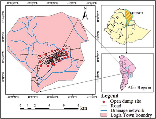
Logia town is located in the Afar Region of Ethiopia, bounded by 11° 43ʹ 55”−11° 45ʹ 24” N latitudes and 41° 03ʹ 29”−41° 05ʹ 41” E longitudes, 578 km north-east of Addis Ababa, the capital city of Ethiopia. Physiography of the area is mainly controlled by volcano-tectonic rather than erosional activities. This area has no much spatial variations of topographic features. It ranges from moderately elevated mountains to flat plains with the general topographic direction from south-west towards the east. Elevation of the area is from 362 − 450 m. Total area of the township is 8418.9 ha (). At an average temperature of 32.3°C, June is the hottest month of the year, when it reaches around 44°C. The lowest average temperature occurs in January (24.2°C). Annual precipitation in the area is around 203 mm. Population of Logia town was 29,675 and as per CSA (Citation2018).
Figure 1. Location map of the study area
Data and methods
Data sets
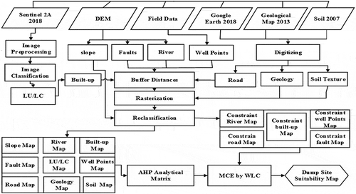
Sentinel 2A data of 2018 having the resolution 10 m were used to prepare primary input thematic maps like land-use/land-cover, geological structures, and lithology with the help of field investigations and secondary maps. Shuttle Radar Topographic Mission (SRTM) digital elevation data of 30 m resolution were used for this study. Soil map and agro-climatic zone map of the study area compiled by Food and Agricultural Organization (FAO) were collected from the Ministry of Agriculture (MoA), Government of Ethiopia. In the field, open dump sites and well points were collected using GPS. In addition, some sample points from different land-use/land-cover types were also collected to verify the current land-use/land-cover types of the area. Interviews with environmental protection officers and people living around the existing landfills were made to get additional information. All input datasets were georeferenced to Adindan UTM Zone 37N coordinate system and reclassified giving weights, and new maps were generated. Spatial geodatabase was designed to include the input datasets, their derived datasets, weighted analysis maps, and the final result. Verification layers were also included in the geodatabase in tabular and shapefile formats. The shape files were exported to the corresponding feature data sets and the raster files were exported as individual raster datasets in the geodatabase. The flowchart of the methodology and using hierarchical model are shown in .
Figure 2. Methodology framework of the study
Criteria determining factors
Relations of solid waste dumping site suitability selection with the natural factors that determine its occurrence were used as criteria, which imply the governing factors of occurrence of suitability cite selection to select best waste dumping sites in the study area. In this study, 10 criteria were selected for evaluating solid waste dump site selection. Factors such as land-use/land-cover, geological structures, lithology, slope, distance to river, built-up, road, soil, drainage, well points were considered in the analysis.
The AHP method is composed of three main steps (Saaty & Vargas, Citation2001). Each layer was internally weighed based on buffer minimum and maximum distances and requirements. The layers were standardized and thematic map of each criterion was produced in the first phase. In the second phase, preference of each criterion relative to rest of the criteria on dump site selection was expressed by assigning weights. Analytical Hierarchical Process Weight Derivation model was employed to compare two criteria at a time based on expert judgment and a pair-wise comparison matrix from which a set of weights referred to as Eigenvectors together with consistency ratios for each of the criteria considered. After assigning external weights to each layer, Weighted Linear Combination (WLC) technique was applied to produce an overall dump site suitability map that combined all the criteria. With the Weighted Linear Combination, factors were combined by applying a weight to each followed by a summation of the results to yield a suitability map as shown in Equationequation 1(1)
(1) .
where S is suitability, wi is the weight of the factor i and xi are the criterion score of factor i.
This procedure can be modified by multiplying the suitability calculated from the factors by the product of the constraints for Boolean constraints to apply as shown in Equationequation 2(2)
(2) .
where Cj is the criterion score of the constraint j.
The weights were developed by providing a series of pair-wise comparisons of relative importance. Based on experience and likely impact on surrounding environment, different weights were assigned to all the parameters. Analytic hierarchy process was used to produce weights. The constraint served to limit the alternatives under consideration, which were expressed in the form of a Boolean logical map in 0 and 1 (Mohammad, Kidokoro, & Syed, Citation2009; Eastman, Citation2012; Shahabi, Keihanfard, Bin Ahmad, Javad, & Amiri, Citation2013; Olusina & Shyllon, Citation2014). EquationEquation 3(3)
(3) is used for Multi-Criteria Evaluation (MCE):
where S is the suitability for a waste disposal site, Wi is the weight of factor i, CI is the criterion for suitability of factor i, rj is the criterion for suitability of constraint j and Π is the product.
Phase 1: suitability model
The phase one step was to decompose the decision-making problem into a hierarchical structure. A structural hierarchy formed for the decision problem consists of several levels. To establish the hierarchy of the main goals of solid waste dump site selection, several criteria were created, including environmental factors, economic factors, and constraints. A Suitability Model was applied in achieving the task, which was Weight Linear Combination (WLC) together with AHP. Analytic hierarchy process was used to capture aspects of the decision. It was used in computing the weights for different criteria used by creating a pair-wise comparison matrix. EquationEquation 4(4)
(4) is used for the model:
S is (WluClu * WsoCso * WgeCge * WslCsl* WroCro * WfaCfa * WriCri * WwpCwp * WbuCbu).
WluWlu: weight and criteria for land-use, WoCso: weight and criteria for soil, WgeCge: weight and criteria for geology (lithology), WslCsl: weight and criteria for slope, WroCro: weight and criteria for road, WfaCfa: weight and criteria for fault, WriCri: weight and criteria for river, WwpCwp: weight and criteria for groundwater well points, WbuCbu: weight and criteria for built-up.
Phase 2: multi-criteria model
In the phase, two step was to create decision tables at each level of the hierarchical decomposition. The matrices capture a series of pair-wise comparisons using relative data and Weight Linear Combination (WLC) were combined, which resulted in a final site selection using the equation:
S is ((r road * r fault * r river * r well point * r built-up) * (WluClu * WsoCso * WgeCge * WslCsl* WroCro * WfaCfa * WriCri * WwpCwp * WbuCbu)).
A number of possible selections were examined for setting a suitable site by taking into consideration multiple criteria and contradictory objectives in the GIS-based MCE technique, using WLC analysis (Al-Ansari, Hanbali, & Knutsson, Citation2012; Chang et al., Citation2008). The pair-wise comparisons of various criteria were organized into a square matrix (). The matrix was known with values from 1 to 9 from whole numbers from 1/9 to 1/2 for fractions. Weights calculated from each column were summed and every factor in the matrix was divided by the sum of the respective column and the first eigenfactor was computed. The second eigenvector was used to compute the percentage weight for each factor contributed to the solid waste dumping site suitability analysis.
Table 1. Pair-wise comparison of factors in relation to solid waste dumping site selection in Logia town
For the phase three step, the rating of each alternative was multiplied by the weights of the sub-criteria and aggregated to determine the local ratings with respect to each criterion. The local ratings were then multiplied by the weights of the criteria and aggregated to determine global ratings (Bhushan & Rai, Citation2004). In this study, every criterion was assigned different ratings on a scale of 1 (least suitable) to 6 (most suitable). Initially, the constrained areas for solid waste dump site selection were masked. Subsequently, the overall score of alternatives in the GIS environment. To produce the best fit set of weights, principal eigenvector of the pair-wise comparison matrix was computed using weight ().
Table 2. Principal eigenvector of the pair-wise comparison matrix
Results
Groundwater well points and river suitability
Solid wastes disposed near the river cause ecological, agricultural and health problems. Considering these problems, the suitability of solid waste dump site map was produced ( and ). Accordingly, 5.2% of the area was unsuitable, 56.8% was less suitable, 17.8% was moderately suitable, 9.3% was suitable, and 10.9% was highly suitable for solid waste disposal site in Logia. Based on the above standards, suitability map of groundwater well point was prepared. indicates that 37.34%, 18.38%, 25.94%, 12.45% and 5.9% of the total area are unsuitable, less suitable, moderately suitable, suitable and highly suitable, respectively, for solid waste disposal site in Logia.
Table 3. Criteria for dump site selection suitability and their rank
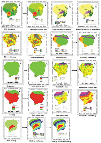
Figure 3. Original and reclassified thematic maps
Slope and land-use/land-cover suitability
The topography of the study area is dominated by a slope of 0–10°, which accounts for 99.1% of the total study area. The second most dominant topography of the study area is 10 ̶ 20° covering 0.87% of total area and the remaining 0.03% of the area is with a slope >20° (). Based on the slope suitability coverages of Logia, the extent of highly suitable, suitable, and unsuitable sites were demarcated and the suitability map was prepared (). Land-use/land-cover map was produced for dumping waste with an overall accuracy of 86%. The land-use map displays the land utilized by human and natural cover in the Logia town. The land-use map indicates the areas of vegetation, bareland, built-up area and water bodies. The majority of the region is occupied by bareland. Based on the land-use/land-cover suitability, the largest part of the study area (80.3%) is highly suitable for solid waste disposal sites, whereas, 5.3% and 13.4% of the area were suitable and less suitable, respectively. The remaining 1% of the study area was unsuitable for solid waste disposal site.
Geology and fault suitability
The present study area contains five geological types such as stratoid basalt, rhyolite, flow basalt, trap basalt and mudflats. Stratoid basalt area has 0.80% extent as unsuitabale, 1.24% as less suitable, 13.43% as moderately suitable, 18.19% as suitable and 66.35% as highly suitable, respectively, for solid waste disposal sites ( and ). The more distance from fault, the more suitable the area for waste disposal to minimize negative effects of dump site. Based on fault proximity suitability, only 1.9% of the extent of the study area is highly suitable and 10.6% of the area is suitable, whereas 23.5% and 64% of the study area are less suitable and unsuitable, respectively, for solid waste disposal sites. As per suitability reclassification, the highest rank was assigned to a buffer distance of >3000 m from f aultand the lowest rank 1000 m from fault was given to unsuitable areas.
Soil suitability
In Logia town area, there are two types of soils such as lithosols (clay) and orthic solonchak (saline). Based on , about 24.1% of the total area is suitable and 75.9% of the area is unsuitable for solid waste disposal sites ().
Road network and built-up area suitability
The road network suitability distance calculated is shown in . In the study area, 0.6% and 7.6% of the area are less suitable and moderately suitable, respectively, while 44.3%, 31.4% and 16.1% of the area is unsuitable, suitable and highly suitable, respectively, for waste disposal sites. Road proximity in the remaining study area is moderate to less suitable, for solid waste disposal sites. The dump site should also be far from commercial buildings, urban green space, service area and industries. Accordingly, 26.5% of the total area is unsuitable, while 33.4% is less suitable for solid waste disposal. The other 22.8%, 15.2%, and 2.1% of the area were moderately suitable, suitable and highly suitable, respectively for waste disposal in Logia town.
Constraint criteria
Constraints are limitations or restrictions, which prohibit certain elements to be taken into account. Constraint maps are used to distinguish between lands suitable and restricted for dump sites. A constraint map for each theme contains 1‟s for suitable land and 0‟s for unsuitable land. Thus, five constraint maps were generated, for factors such as groundwater well points, river, road network, fault and built-up area.
Groundwater well
Ten functional groundwater well points were recorded during field survey. Using proximity tools, buffer zones were prepared around each well. Dump site should not be located within 500 m distance from groundwater wells points. shows the proximity distance from well point to locate the best site for a waste dump site in Logia Town.
River and road constraint buffer distance suitability map
The river constraint map was created based on buffer distance < 500 m as unsuitable and >2000 m as suitable (). Distance from existing roads is an important factor in locating waste conversion facilities. The road constraint map of buffer distance <700 m was unsuitable and one suitable on the road network proximity standard ().
Fault and built-up area constraint buffer distance suitability map
For the current study, less than 1000 m buffer distance from faults were considered as 0 (unsuitable) for solid waste disposal site due to high permeability of soil near the fault. Areas >1000 m buffer distance of fault was considered as 1 or suitable (). The built-up area constraint map was created in order to define dump site hazards, such as scavenging animals and unfavorable odor and noise. The buffer zone of built-up area distance <700 m as assigned 0 (unsuitable), while >700 m as assigned to be 1 (suitable) for locating a solid waste disposal location ().
Constraint map
Five constraint maps were produced such as well points, river, road, fault and built-up area using overlay function (using direct multiplication of binary integer values) to create the final constraint map. Finally, from the total area of the study unsuitable area cover of 7176.8 ha (85.2%) and suitable area cover of 1241.2 ha (14.8%) were recognized ().
Table 4. Constraint criteria accepted for dump site selection
Waste dumpsite suitability
The datasets derived have different degrees of influence of solid waste dumping site selection. Hence, from the principal eigenvector calculation, the relative importance of each parameter was determined. The decreasing order of importance of dump sites was fault–30.58%, soil–21.93%, lithology–15.42%, land-cover 10.88%, road 7.64%, built-up 5.34%, river 3.7%, well depth 2.61% and slope 1.9%. The higher the weight, the more influence a particular factor will have in the solid waste dumping site selection model. The factors involved were examined according to their relative importance in solving the stated problem and weights were assigned. All the reclassified factor layers were used in weighted overlay analysis () by applying Equationequation (5)(5)
(5) , and a final solid waste dumping site selection map of Logia town was produced (): (Fault) × 0.3058 + (soil) × 0.2193 + (lithology) × 0.1542 + (land-cover) × 0.1088 + (road) × 0.0764 + (built-up) × 0.0534 + (river) × 0.0370 + (well depth) × 0.0261 (slope) × 0.0190 = Solid waste dumping site selection.
Figure 4. Integration of reclassified raster maps
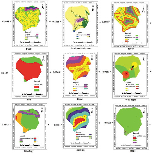
Figure 5. Overall solid waste dump site suitability map for Logia town
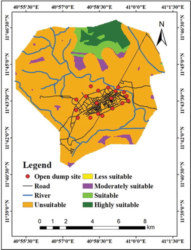
Out of the total study area, about 5.93% (499.43 ha) fall under highly suitable as the area satisfies environmental, social and economic criteria such as fault, built-up area, surface water, geology, land-use/land-cover, soil, slope, and road network. Such areas were located in the northern part of the study area. Suitable area covers an extent of 6.5% (537.5 ha), moderately suitable areas 3.23% (272 ha), less suitable area 1.02% (86.10 ha) and the remaining 83.32% (7154.61 ha) unsuitable for solid waste disposal sites. The red points in the map indicate the existing open dump site surrounding Logia town ().
Discussion
The present study represents an important step in addressing a critical gap in the detection of waste disposal sites and to enhance cost-effectiveness and efficiency of waste management efforts. Due to their ability to manage large volumes of spatial information from various resources, GIS is ideal for site selection studies (Kao et al., Citation1997), and are being widely applied in the recent past for site selection studies (Curtis & Hardin, Citation2000; Haaren & Fthenakis, Citation2011; Nikolakaki, Citation2003; Thomas, Citation2002; Woodhouse, Lovett, & Dolman, Citation2000). The integration of both GIS and multi-criteria techniques improves decision-making because it establishes an environment for transformation and combination of geographical data and stakeholders preferences (Malczewski, Citation1997).Solid waste dumping site should be located at a suitable distance from roads to facilitate transportation and consequently to reduce relative costs. In Logia, waste dumping is mostly on the Djibouti roadside. According to Sam and Steven (Citation2017), a minimum distance of 700 m buffer should be maintained for road suitability dumpsite location. Kontos et al. (Citation2005), Al-Hanbali, Alsaaideh, and Kondoh (Citation2011) and Irfan Yesilnacar, Lütfi, Basak & Vedat (Citation2012) used multiple buffer ring extents and the grading values for roads. At present Logia town has grown at an unexpected growth and as a result, the distance of the facility to the nearest residential area is only few kilometers.
Groundwater circulation and the downward flow of pollutants through rocks and soils depend on the hydrogeological condition of the materials; more specifically hydraulic properties such as porosity, permeability, and transitivity (Tsegaye Mekuria, Citation2006). The proximity of a solid waste dump site to a groundwater well point is an important environmental criterion in the dump site selection so that well points may be protected from the runoff and discharge. Therefore, solid waste disposal sites should be away from wells. Additionally, it can have irreversible human and environmental effects. Distance from groundwater well was considered as an important to prepare the water sources for activities and drinking water, and they are influenced by many factors including agricultural and reactions occurred in landfill sites (Khan & Samadder, Citation2014). In Logia town area, there are 10 functional wells (Eskandari, Homaee, & Mahmodi, Citation2012; Sumathi et al., Citation2008). Existing landfill site is clearly unsuitable with respect to public health, hygiene, noise, dust and odor. The overall dump site suitability selection showed five dump site suitability classes, viz. unsuitable (restricted), less suitable, moderately suitable, suitable and highly suitable. Bare-land, water body, built-up areas and forest lands were used for dump site selection processes due to their land-use/land-cover effect and values. Bare land in the study area was identified as the best option for solid waste dump sites. Areas with slope >20° were excluded as they were unsuitable and areas with slope 0−10° were found to be the suitable for dump sites (Akbari, Citation2008). Areas within 700 m radius were excluded to minimize public health effects (Sam & Steven, Citation2017).
Area-wise calculation of suitability classes showed 7176.8 ha (85.2%) of the study area is unsuitable (restricted) for waste dump sites in Logia town. This restricted area included well points, river/streams, fault, road, built-up area in the first order, followed by permeable locations, faults, geology, areas with a steep slope (>20°), built-up and forest and areas close to roads. Ground/surface water-related criteria are more influential than rest of the criteria as they need protection against leachate contamination from dump sites (Tyowuah & Hundu, Citation2017). According to Tyowuah and Hundu (Citation2017), contamination of ground/surface water resources by leachate is a principal concern in relation to waste disposal sites. Deep groundwater areas are preferable as chances of groundwater pollution will be minimized with increasing depth . Waste disposal should also be away from faults (Rafee, Syed, Afshin & Nematolah, Citation2011). Lithology is one of the important environmental factors that should be considered for solid waste disposal site selection processes (Bezawit Mitku, Engdawork Admassu, Tadege Arefayne & Bedaso Gichila, Citation2013). The degree of permeability (strength and weakness) decreases from rhyolite to basaltic fissure flow, lacustrine, silt, clay and sand and pyroxene (olive) basalt. Suitability increases from pyroxene (olive) basalt to Rhyolite (Sener, Su¨zen, & Doyuran, Citation2006).After eliminating the restricted land with the combination of environmentally sensitive, socially important and economically significant areas, only 537.5 ha. (6.4%) and 189.4 ha (2.2%) of the study area were identified as suitable and highly suitable, respectively, for waste dump sites. Waste dump site in these areas is preferred because of the least effects that may cause on the environment and public. Most of the highly suitable landfill sites are situated in the northern part of the study area. The south-eastern part of Logia town having high elevation was excluded from the selection of dump site as it comprises the recharge area for low-lying regions of the town. Similarly, the south-west part of Logia is a potential source of groundwater for the town and its surroundings and hence excluded from the dump site. Therefore, a high suitable dump site should be identified most preferably from the northern part of Logia town.The current open dump site is located in an unsuitable site. It is placed surrounding the built-up area, roadsides and nearby river. Considering the effect of solid waste on environment, health, economy and other aspects of human life, the suggested selected site can be accessed by road. A study conducted by Olusina & Shyllon (Citation2014) in Lagos, Nigeria indicated that landfill sites generated based on the criteria sets are to be accessible by road. It is evident that multi-criteria decision making with GIS integrated methods would be useful for environmental, human health and developmental issues and they should become statutory obligations for location of dump site selection in human dwellings.
Conclusion
The generation of solid waste has expanded extensively amid the ongoing past because of the rising worldwide population and rapid urbanization and its improper disposal and poor management in Logia town. The goal of this study was to pursue proper selection process while avoiding environmental problems, and to suggest suitable site for landfill using GIS and multi-criteria decision-making techniques to facilitate shifting the present dumpsite to an alternative location. This site is easy to access for disposal of solid wastes. It is located in the west, northern and east of the study area. There are highly suitable and suitable classes, which might be suitable from environmental, transportation and economic point of view. The use of AHP with GIS and remote sensing for identification of suitable solid waste dumping site will minimize environmental risk and human health problems. In addition, the described methodology is user-friendly and can employed by authorities in developing countries to lower both time and cost. Hence, it is advisable that before resorting to the landfill option, town and city administrations should consider waste minimization through recycling and reuse, and waste transformation alternatives.
Acknowledgments
We are thankful to the School of Earth Sciences, College of Natural and Computational Sciences, Addis Ababa University for providing funds and facilities for this research. We are also grateful to the Ministry of Agriculture and Geological Survey of Ethiopia for providing valuable data for this research. The authors are thankful to the Logia Town Municipality office for providing the Census data, solid waste data and master plan of the town. The authors are grateful to the editor and two anonymous reviewers whose useful comments to improve this manuscript.
Disclosure statement
No potential conflict of interest was reported by the authors.
Correction Statement
This article has been republished with minor changes. These changes do not impact the academic content of the article.
References
- Abedi-Varaki, M., & Davtalab, M. (2016). Site selection for installing plasma incinerator reactor using the GIS in Rudsar county, Iran. Environmental Monitoring and Assessment, 188(6), 353.
- Ajay, S. (2019). Remote sensing and GIS applications for municipal waste management. Journal of Environmental Management, 243, 22−29.
- Akbari, V. (2008). Landfill site selection by combining gis and fuzzy multi-criteria decision analysis a case study Bandar Abbas. Journal of Department of Surveying and Geomatics Engineering. University of Tehran, Iran.
- Al-Ansari, N. A., Hanbali, A., & Knutsson, S. (2012). Locating solid waste landfills in Mafraq city, Jordan. Journal of Advanced Science and Engineering Research, 2, 40–51.
- Al-Hanbali, A., Alsaaideh, B., & Kondoh, A. (2011). Using GIS-based weighted linear combination analysis and remote sensing techniques to select optimum solid waste disposal sites within Mafraq city, Jordan. Journal of Geographic Information System, 3, 267−278.
- Bezawit, M., Engdawork, A., Tadege, A., & Gichila, B. (2013). Geological map of serdo map sheet (NC 37-4). Addis Ababa: Geological Survey of Ethiopia.
- Bhushan, N., & Rai, K. (2004). Strategic decision making: Applying the analytic hierarchy process (pp. 172). New York: Springer-Verlag.
- Chang, N. B., Parvathinathan, G., & Breeden, J. B. (2008). Combining GIS with fuzzy multicriteria decision-making for landfill siting in a fast-growing urban region. Journal of Environmental Management, 87, 139−153.
- Charnpratheep, K., Zhou, Q., & Garner, B. (1997). Preliminary landfill site screening using fuzzy geographical information systems. Waste Management and Research, 15, 197−215.
- Chen, W., & Kao, J. (2008). Air pollution directional risk assessment for siting a landfill. Journal of the Air & Waste Management Association, 58, 1539−1545.
- Church, R. L. (2002). Geographical information systems and location science. Computers & Operations Research, 29(6), 541–562.
- Coban, A., Ertis, I. F., & Cavdaroglu, N. A. (2018). Municipal solid waste management via multi-criteria decision making methods: A case study in Istanbul, Turkey. Journal of Cleaner Production, 180, 159–167.
- CSA. (2018). Central Statistical Agency of Ethiopia Population and Housing Census Report. Addis Ababa.
- Curtis, N. T., & Hardin, P. H. (2000). Remote sensing/GIS integration to identify potential low-income housing sites. Cities, 17, 97–109.
- Eastman, J. R. (2012). IDRISI Selva manual version 17. Production. Worcester: Clark University.
- Ebistu, T.A, & Minale, A.S. (2013). Solid waste dumping site suitability analysis using geographic information system (gis) and remote sensing for bahir dar town, north western ethiopia. African Journal Of Environmental Science and Technology, 7(11), 976−989.
- EGSSAA. (2009). Environmental guidelines for small-scale activities in Africa. Solid waste: Generation, handling, treatment and disposal, USA.
- Elmira, S., Behzad, N., Mazlin, B. M., Ibrahim, K., Halima, T., & Saadiah, H. (2010). Urban solid waste management based on geo-informatics technology, University Putra Malaysia, Malaysia. Journal of Public Health and Epidemiology, 3, 54 ̶ 60.
- Emun, G. (2010). Multi-criteria approach for suitable quarry site selection in Addis Ababa using remote sensing and GIS. Unpublished M.Sc. Thesis, Addis Ababa University, Addis Ababa.
- Ersoy, H, & Bulut, F. (2009). Spatial and multi-criteria decision analysis-based methodology for landfill site selection in growing urban regions. Waste Management & Research, 27, 489−500. doi:10.1177/0734242X08098430
- Eskandari, M., Homaee, M., & Mahmodi, S. (2012). An integrated multi criteria approach for landfill siting in a conflicting environmental, economic and socio-cultural area. Waste Management, 32(8), 1528−1538.
- Gizachew, K., Suryabhagavan, K. V., Mekuria, A., & Hameed, S. (2012). GIS-based solid waste landfill site selection in Addis Ababa, Ethiopia. International Journal of Ecology and Environmental Sciences, 38, 59−72.
- Haaren, R., & Fthenakis, V. (2011). GIS-based wind farm site selection using spatial multi-criteria analysis (SMCA): Evaluating the case for New York State. Renewable and Sustainable Energy Reviews, 15, 3332–3340.
- Hammer, G. (2003). Solid waste treatment and disposal: Effect on public health and environmental safety. Biotechnology Advances, 22, 71̶ 79.
- Hasan, P., Ramin, N. N., Amir, H. M., Kamyar, Y., & Zabihalah, C. (2019). Landfill site selection using a hybrid system of AHP-Fuzzy in GIS environment: A case study in Shiraz city, Iran. MethodsX, 6, 1454−1466.
- Hering, J. G. (2012). An end to waste? Science, 337(6095), 1623−1623.
- Irfan, Y. M., Lütfi, S. M., Basak, S. K., & Vedat, D. (2012). Municipal solid waste landfill site selection for the city of Sanliurfa-Turkey: An example using MCDA integrated with GIS. International Journal of Digital Earth, 5, 147−164.
- Joosten, L. A. J., Hekkert, M. P., & Worrell, E. (2000). Assessment of the plastic flows in The Netherlands using streams. Resources, Conservation and Recycling, 30(2), 135–161.
- Joseph, K., Rajendiran, S., Senthilnathan, R., & Rakesh, M. (2012). Integrated approach to solid waste management in Chennai: An Indian metro city. Journal of Material Cycles and Waste Management, 14, 75–84.
- Kao, J. (1996). A raster-based C program for siting a landfill with optimal compactness. Journal of Computers and Geosciences, 22, 837−847.
- Kao, J., Lin, H., & Chen, W. (1997). Network geographic information system for landfill siting. Waste Management and Research, 15, 239−253.
- Kapilan, S., & Elangovan, K. J. (2018). Potential landfill site selection for solid waste disposal using GIS and multi-criteria decision analysis (MCDA). Journal of Central South University, 25, 570−585.
- Khan, D., & Samadder, S. (2014). Municipal solid waste management using geographical information system aided methods: A mini review. Waste Management and Research, 32, 1049–1062.
- Kontos, T. D., Komilis, D. P., & Halvadakis, C. P. (2005). Siting MSW landfills with spatial multiple criteria analysis methodology. Waste Management, 25, 818−832.
- Leao, S., Bishop, I., & Evans, D. (2001). Assessing the demand of solid waste disposal in urban region by urban dynamics modeling in a GIS environment. Resources, Conservation and Recycling, 33, 289−313.
- Lein, J. K. (1990). Exploring a knowledge-based procedure for developmental suitability analysis. Applied Geography, 10, 171–186.
- Lin, H., & Kao, J. (1999). Enhanced spatial model for landfill siting analysis. Journal of Environmental Engineering, 125, 845−851.
- Lino, F. A. M., & Ismail, K. A. R. (2017b). Incineration and recycling for MSW treatment: Case study of Campinas, Brazil. Sustainable Cities and Society, 35, 752–757.
- Malczewski, J. (1997). Propagation of errors in multicriteria location analysis: A case study. In G. Fandel & T. Gal (Eds.), Multiple criteria decision making (pp. 154–155). Berlin: Springer.
- Mekuria, T. (2006). A multi-criteria analysis for solid waste disposal site selection using Remote Sensing and GIS, Addis Ababa University, Ethiopia. Unpublished Master’s Thesis, 11–25.
- Mohammad, R. H., Kidokoro, T., & Syed, A. I. (2009). Landfill demand and allocation for municipal solid waste disposal in Dhaka city an assessment in a GIS environment‖. Journal of Civil Engineering (IEB), 37, 133–149.
- Mutlutürk, M., & Karagüzel, R. (2007). The landfill area quality (LAQ) classification approach and its application in Isparta, Turkey. Environmental and Engineering Geoscience, 13, 229−240.
- Muttiah, R. S., Engel, B. A., & Jones, D. D. (1996). Waste disposal site selection using GIS-based simulated annealing. Computers & Geosciences, 22, 1013−1017.
- Nas, B., Cay, T., & Iscan, F. (2008). Selection of MSW landfill site for Konya, Turkey using GIS and multi-criteria evaluation. Environmental Monitoring and Assessment, 160, 491–500.
- Nikolakaki, P. (2003). A GIS site-selection process for habitat creation: Estimating connectivity of habitat patches. Landscape and Urban Planning, 68, 77–94.
- Olusina, Joseph O, & Shyllon, D.O. (2014). Suitability analysis in determining optimal landfill location using multi-criteria evaluation (mce), gis & remote sensing. International Journal Of Computational Engineering Research, 4(6), 7−20.
- Othman, N., Kane, T., & Hawrami, K. (2017). Environmental health assessment in Sulaymaniyah City and Vicinity. Tech. Rep.
- Panepinto, D, & Zanetti, M.C. (2018). Municipal solid waste incineration plant: a multi-step approach to the evaluation of an energy-recovery configuration. Waste Management, 73, 332−341. doi:10.1016/j.wasman.2017.07.036
- Philippe, F., & Culot, M. (2009). Household solid waste generation and characteristics in Cap-Haitien city: Republic of Haiti. Resources, Conservation and Recycling, 54, 73–78.
- Rafiee, R., Syed, E., Afshin, D., & Nematolah, K. (2011). Siting transfer stations for Municipal solid waste using a spatial multi-criteria analysis. Environmental and Engineering Geo-Science, 17, 143–154.
- Rezaei, M., Ghobadian, B., Samadi, S. H., & Karimi, S. (2018). Electric power generation from municipal solid waste: A techno-economical assessment under different scenarios in Iran. Energy, 152, 46–56.
- Saaty, T., & Vargas, L. (2001). Methods, concepts and applications of the analytic hierarchy process. Boston: Kluwer Academic Publishers.
- Sadek, S., El-Fadel, M., & El-Hougeiri, N. (2001). Optimizing landfill siting through GIS application. Seventeenth International Conference on Solid Waste Technology and Management, 2124 October 2001,The Journal of Solid Waste Technology and Management, Philadelphia, USA.
- Sam, Z., & Steven, J. (2017). Site suitability analysis for solid waste landfill site location using geographic information systems and remote sensing: A case study of Banket town board, Zimbabwe. Review of Social Sciences, 2, 19−31.
- Sener, B., Su¨zen, M. L., & Doyuran, V. (2006). Landfill site selection by using geographic information systems. Environmental Geology, 49, 376−388.
- Sener, S., Sener, E., Nas, B., & Karagüzel, R. (2009). Combining AHP with GIS for landfill site selection: A case study in the Lake Beysehir. Waste Management, 30, 2037–2046.
- Sener, S, Sener, E, Nas, B, & Karagüzel, R. (2010). Combining ahp with gis for landfill site selection: a case study in the lake beysehir catchment area (konya, turkey). Waste Management, 30, 2037−2046. doi:10.1016/j.wasman.2010.05.024
- Shahabi, H., Keihanfard, S., Bin Ahmad, B., Javad, M., & Amiri, T. (2013). Evaluating Boolean, AHP and WLC methods for the selection of waste landfill sites using GIS and satellite images. Environmental Earth Science, 71, 4221 ̶ 4233.
- Siddiqui, M., Everett, J., & Vieux, B. (1996). Landfill siting using geographic information systems: A demonstration. Journal of Environmental Engineering, 122, 515−523.
- Simsek, C., Kıncal, C., & Gündüz, O. (2005). A solid waste disposal site selection procedure based on groundwater vulnerability mapping. Environ Geol. doi:10.1007/s00254-005-0111-2
- Sumathi, V. R., Natesan, U., & Sarkar, C. (2008). GIS-based approach for optimized siting of municipal solid waste landfill. Waste Management, 28, 2146−2160.
- Thomas, R. M. (2002). A GIS-based decision support system for brownfield redevelopment. Landscape and Urban Planning, 58, 7–23.
- Tyowuah, M., & Hundu, W. (2017). Site suitability analysis for solid waste disposal using geospatial technology: A case study of Katsina-Ala township, Katsina-Ala, Benue State. International Journal of Science and Research, 6, 2319–7064.
- UNEP. (2005). Selection, design and implementation of economic instruments in the solid waste management sector in Kenya. New York, USA.
- United Nations. (2017, December 2). World population prospects: 2017 revision population database. Retrieved from http://www.un.org/esa/population/unpop.htm.
- Visvanathan, C., & Glawe, U. (2006). Domestic solid waste management in South Asian countries. A Comparative Analysis. Synthesis report of the 3R South Asia Expert Work Shop, Kathmandu, Nepal. 1–14.
- Woodhouse, S., Lovett, A., & Dolman, P. (2000). Using a GIS to select priority areas for conservation. Computers, Environment and Urban Systems, 24, 79–93.
- Yesilnacar, M. Đ., & Çetin, H. (2007). An environmental geomorphologic approach to site selection for hazardous wastes. Environ Geol. doi:10.1007/s00254-007-1115
- Zamorano, M., Molero, E., Hurtado, A., Grindlay, A., & Ramos, A. (2008). Evaluation of a municipal landfill site in Southern Spain with GIS-aided methodology. Journal of Hazardous Materials, 160, 473−481.