
ABSTRACT
Hydrogeomorphic factors were suspected to contribute to the persistent gully erosion taking place in Nanka, Ogwashi and Benin formations underlying the southern Anambra State, Nigeria. Therefore, this study investigated the impact of hydrology and geomorphology on gully development and expansion in this area using integrated field survey, hydrological, geotechnical and geomorphological approaches. Field survey and hydrological results revealed that the study area is characterized by numerous surface water bodies and shallow groundwater systems. Both the surface waters and groundwater have a westward flow direction, from areas of high elevations on the Nanka Formation to areas of low elevations on the Ogwashi and Benin formations. Geotechnical results revealed that the soils are permeable, weak, easily dispersible and collapsible. Geomorphological analysis showed that the area is characterized by uneven badland topography, high gully slope gradients, concave slopes, poor land-use practices, and low vegetation cover. Generally, the results of this study indicated that hydrogeomorphology and soil engineering properties substantially influence the gullying processes in the area. However, areas underlain by the Nanka Formation have higher gullying intensity than in areas underlain by the Ogwashi and Benin formations due to variations in their hydrogeomorphological characteristics.
Introduction
Of all the natural hazards reported from different regions around the globe, gully erosion and mass wasting are the ones peculiar to many parts of Nigeria. Gullies are natural geologic hazards which arise due to persistent loss of soils. This geologic hazard has been a serious environmental problem in the southeastern Nigeria, causing the degradation of arable lands, destruction of civil engineering infrastructures and underground utilities; silting and pollution of surface water bodies, and loss of estates and resident lands, etc. However, reports have shown that amongst the southeastern States in Nigeria, Anambra State has the highest number of gullies, followed by Enugu, Imo, Abia, and Ebonyi States, respectively (Igbokwe et al., Citation2008; Okoyeh, Akpan, Egboka, & Okeke, Citation2014). The variations in the gullying intensity could be due to differences in causative factors and types of geologic formations underlying these States. Anambra State has more of the youngest and friable sedimentary deposits whereas Ebonyi State (with the fewest number of gullies) has more of the oldest and well-consolidated sediments (Nwajide, Citation2013). However, different erosion researches conducted in this region reported that several factors, such as poor soil engineering properties, inadequate road construction, poorly constructed and poorly maintained surface drainage facilities, poor land-use practices and poor vegetation cover, etc., contribute to the continuous soil erosion and the development and expansion of erosion gullies in this part of Nigeria (Emeh & Igwe, Citation2017, Citation2018; Igwe, Citation2012; Igwe & Egbueri, Citation2018; Nwajide, Citation2013; Okoyeh et al., Citation2014).
In the southern Anambra State, the towns especially exposed to this erosion menace include Uli, Okija, Ozubulu, Oraukwu, Nanka and Ekwulobia. These towns are the major focus of the current study. Recent studies conducted by Obiadi et al. (Citation2014), Chikwelu and Ogbuagu (Citation2014), and Igwe and Egbueri (Citation2018) on the gullies in the southern Anambra State majorly reported on the geological and geotechnical properties of the soils. In their studies, Obiadi et al. (Citation2014) and Chikwelu and Ogbuagu (Citation2014) reported that the soils in this area are very weak and dispersible. They further hinted that anthropogenic activities also predispose the soils to erosion. Similarly, Igwe and Egbueri (Citation2018) revealed that the poor geotechnical characteristics of the soils and improper land use are the major causes of erosion within the area. However, recent research by Emeh and Igwe (Citation2018) has revealed that environmental pollution is also one of the major factors contributing to the high susceptibility of the lateritic soils in part of the area to water erosion.
Consequent to the research findings of the previous authors who have worked in this region, several mitigation recommendations, including construction of check dams in critical areas, construction of adequate drainage channels, planting of vegetation cover, roadway grading, landscaping, stabilization of soils, terracing of soil slopes, dewatering, construction of embankments, and establishment of soil conservation schemes were proffered (Chikwelu & Ogbuagu, Citation2014; Egboka & Nwankwor, Citation1985; Obiadi et al., Citation2014; Okoyeh et al., Citation2014). Unfortunately, many of these remedial measures have not been fully adopted, and the adopted ones have not been able to completely control or halt gully erosion within the study area. Possibly, the mitigation measures fail because a comprehensive list of component factors contributing to the erosion processes has not been generated. Hence, further inquiry is required to know more of the component causative factors accelerating gullying in this area. In line with this thought, hydrogeomorphic factors were suspected to contribute to the persistent gullying in the area. The failure of previous efforts to halt the expansion of gullies in this area could be because of poor understanding of the close interactions between the geomorphologic and hydrological processes.
Previous researches from different regions of the world have shown that the mechanical interactions of surface and groundwater with landscapes could play significant roles in the development and expansion of gullies (Mahmood, Kim, Ashraf, & Ziaurrehman, Citation2016; Moges & Holden, Citation2008; Ownegh & Nohtani, Citation2004; Poesen, Citation2011; Rockwell, Citation2002; Scheidegger, Citation1973; Shellberg, Brooks, Sencer, & Ward, Citation2013; Sophocleous, Citation2002; Tebebu et al., Citation2010). Similarly, several researchers have reported the influences of geomorphology and hydrology on soil erodibility in different parts of the southeastern Nigeria (Egboka & Nwankwor, Citation1985; Egboka, Nwankwor, & Orajaka, Citation1990; Igwe, Citation2017; Igwe, Mode, Nnebedum, Okonkwo, & Oha, Citation2013; Nwajide, Citation1979, Citation1992; Obi, Okogbue, & Nwajide, Citation2001; Ofomata, Citation1965, Citation1988; Ogbukagu, Citation1979; Okoyeh et al., Citation2014). In some parts of Anambra State, Okoyeh et al. (Citation2014) assessed the influence of surface and subsurface water level dynamics in the development of gullies. Their research indicated that hydrological processes play noticeable role in the initiation and development of gullies and other erosion-induced environmental problems. However, no previous studies integrated geomorphologic and hydrologic attributes in the evaluation of gully erosion processes within most parts of the current study area (i.e. southern Anambra State).
Therefore, this paper aims at identifying and evaluating the potential impacts of hydrology and geomorphology on the development and expansion of major erosion gullies within three different geological units (the Nanka, Ogwashi, and Benin formations) in the southern Anambra State, Nigeria. To better accomplish the research aim, an integrated field survey, hydrological, geotechnical and geomorphological approach were used. Through this research, the authors hope to contribute to the understanding of the various factors affecting soil erosion in the area. Information provided in this paper is important to researchers, citizens, local policymakers, non-governmental organizations and the State Government towards planning, management and mitigation of gully erosion hazards in the State.
Location, geology and physiography of the study area
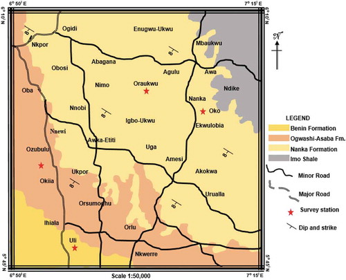
The study area is located within latitudes 5º 45′ to 6º 10′N and longitudes 6º50′ to 7º15′E, in the southeast Nigeria. Based on the geology, the area is underlain by three formations, the Eocene Nanka, Oligocene-Miocene Ogwashi, and Oligocene Benin formations (). The three formations are characteristically composed of sands interbedded with thin layers of mudrocks and ironstones (Nwajide, Citation2013). Studies have shown that the formations are generally extensive in the southern Nigeria and inherently weak and collapsible (Chikwelu & Ogbuagu, Citation2014; Egbueri, Igwe, & Nnamani, Citation2017; Igwe, Citation2012; Igwe & Egbueri, Citation2018; Nwajide, Citation2013; Obiadi et al., Citation2014; Okoyeh et al., Citation2014). Despite their age differences, all the soils underlying the study area are predominantly composed of loose and poorly consolidated fine-grained sand materials with low clay content and little or no coarse-grained aggregates (Egbueri et al., Citation2017; Igwe & Egbueri, Citation2018).
Figure 1. Geologic map of the study area showing the survey stations
In addition, the study area is characterized by uneven topography, several surface water networks and humid tropical rainforest belt (Igwe & Egbueri, Citation2018), although human activities including deforestation, urbanization, roadway construction, indiscriminate agricultural practice and other forms of man-induced activities have led to the loss of the primary forest (Okoyeh et al., Citation2014). The mean-monthly temperatures in the study region vary from 22°C to 28°C in the wet season and between 28°C and 32°C in the dry season (Igwe, Citation2017). Dry and rainy seasons are the two seasons experienced in the area. The rainy season lasts from April to October whereas the dry season lasts from November to March. The study area experiences heavy precipitation, especially in peak of the rainy season. The average annual rainfall in the region is between 1,400 and 2,500 mm (Eze, Citation2007). However, there may be variations in the intensity of the rainfall depending on the prevailing topography. In such incident, daily rainfall amount may increase to 20–30% of the mean annual rainfall in the area (Igwe, Citation2015). The heavy rainfall often leads to such hazards as flooding, soil leaching and erosion. In the southeastern Nigeria, the severity of mass movements (especially those associated with gully formation) has not only increased environmental degradation but has also limited the mitigation options available to environment stakeholders (Igwe, Citation2017).
Research methodology
Identification of surface waters and gully attributes
Surface water distribution, land use and land cover information were acquired during the field survey. Records of surface water widths, depths, flow directions and elevations; gully slope (gradients, aspects, and curvatures) were also identified during the field survey. The width and depth of the surface waters were measured using a measuring tape and pole, respectively. Generally, the widths of the surface waters were measured relative to the lengths of bridges that crossed them. Likewise, the depths were measured standing on the bridges with long measuring pole (of about 10 m). Unfortunately, some of the surface water networks had no bridges, and thus their widths were roughly estimated and their depths estimated by interviewing the villagers. The flow direction was acquired using a Brunton compass by pointing the compass in the flow direction of the stream and reading the corresponding bearing, while the elevation was measured using a GPS (GARMIN GPSMAP 78S series) which digitally reports the latitude, longitude and elevation of the reference point. Attributes (average widths, depths, and lateral extents) of the major gullies were also measured during the field survey.
Geoelectrical survey
Four VES (Vertical Electrical Sounding) and ADMT (Audio Magneto Telluric) surveys were carried out along the major gullies in Uli, Okija-Ozubulu, Oraukwu, and Nanka-Ekwulobia, in order to delineate the groundwater levels around these gullies (Igwe, Citation2017; Okoyeh et al., Citation2014). The ADMT was integrated with the VES in order to ensure the validity and accuracy of the latter. Because of their close proximity, one station was chosen for the Okija and Ozubulu gullies. The same applies for the Nanka and Ekwulobia gullies.
The VES method was based on the estimation of the electrical conductivity or resistivity of the hydrostratigraphic sequences. ABEM SAS 1000 (produced by ABEM Instrument, Sweden) set at “sounding stations” was employed for the survey. Using the Schlumberger array method, induced polarization mode being activated, current was passed into the earth from the source electrode, A, and received at the sink electrode, B, at every AB/2 from the midpoint. Measuring at IP mode enabled simultaneous acquisition of IP and self-potential (SP) data. Generally, at each sounding station, a straight line of about 200 m (on average) was measured having a midpoint, O, for current electrode spread. The potential electrodes were set at 0.5 m from the midpoint, O, whereas the current electrodes were set at 1.5 m from the midpoint. From the 1.5 m points, the current electrodes were simultaneously shifted sideways up to 200 m. For every AB/2 the potential difference was then measured by the earth resistivity meter at the corresponding MN/2 distance which was the distance of the potential electrodes. Since prior to the measurements, the array method was chosen and the AB/2 and MN/2 was set to their corresponding distances, direct measurement of apparent resistivity was obtained. This VES method is similar to those outlined/described in Roy and Elliot (Citation1981), Singh (Citation2005), Akpan et.al (Citation2009), Okoyeh et al. (Citation2014), and Igwe (Citation2017). The ADMT method, which was based on the estimation of electrical potential from the sequences measured in millivolts (mV), is similar to that of the VES. However, the ADMT surveys were carried out from the midpoint, O, at consistent 5 m intervals up to 150 m.
The geoelectrical data obtained from the VES and ADMT surveys were used in creating their respective models. IP models were also created and they correlated well with the VES models. However, in order to reduce the number of figures produced for the height of water tables and for the purpose of clarity and simplicity, only the VES and ADMT models are presented in this paper. The hydrological and geomorphological modelling involved the use of various softwares in processing most of the data acquired during the field surveys. The VES data were modelled using INTERPEX-1D (IX-1D), while the ADMT models were created using Microsoft-Excel (v. 2016). With these, the generated geoelectric sections were used in delineating the hydrostratigraphic succession around the major gullies. A model showing the aquiferous layers and flow direction was developed using the VES data, as reported in Igwe (Citation2017).
Geotechnical analysis
Soil samples were collected during the field survey for geotechnical analysis. A total of four samples were collected from each of the three formations, in an attempt to further clarify the information provided by the geoelectric survey. Two samples were collected from Uli and Okija gullies to represent the Benin and Ogwashi formations, respectively. Two samples were collected to represent the Nanka Formation (one from Oraukwu gully and the other from Nanka gully). The soils were analyzed for grain size distribution, moisture contents, permeability coefficients and direct shear strength. The laboratory tests were done following the recommendations and soil testing standards of the American Society for Testing and Materials (ASTM) as described by Kalinski (Citation2011).
Geomorphology survey
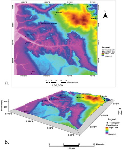
In order to determine the geomorphology of the study area, the GARMIN GPS was used to acquire the latitude, longitude and elevation of different locations under consideration. This data was also integrated with the DEM (Digital Elevation Model) data acquired by SRTM (Shuttle Radar Topographic Mission) from the permission of the USGS using ArcGIS (v. 10.4) and Surfer 10 GIS modelling and analytical tools. Following the methods described in Crozier (Citation1984), Highland and Bobrowsky (Citation2008), Igwe (Citation2015, Citation2017)), the 2D, 3D, and drainage system maps of the study area were generated. Slope gradients and aspects were measured and estimated using Brunton compass while slope curvature was estimated using an empirical approach (based on observation). The land use and land cover maps relatively matching our field observations were adopted from Ifeka and Akinbobola (Citation2015).
Results and discussion
Hydrological and geotechnical characteristics
Surface water distribution and characteristics
The area is characterized by several surface water networks which drains the area (). These streams are configured into different drainage patterns, mostly dendritic and trellis drainage pattern. In the Uli area, two streams were recorded, the Atammiri and Enyinja rivers. The Ulasi-Okija, Okpu, and Okposi rivers drain the area around Okija and Ozubulu, while Nanka-Ekwulobia area is drained by the Iyeagu rivers. There is also the presence of two lakes (Agulu and Atama lakes) within Agulu area which holds most of the surface runoffs within the area. In the northernmost part of the study area, numerous streams which include Nwocha, Iyi-Udo, Ezigbo, Oridike, Mvomvo, Mmaba, and Iyi-Ukwu rivers drain the area around Oraukwu. All these rivers and streams are tributaries to the Niger River (west of the study area), which, in turn drains into the Atlantic Ocean (south of the study area). The abundance and complex configuration of these surface water bodies is believed to accelerate the rate of sediment loss from these gullies (Egboka & Nwankwor, Citation1985; Igwe, Citation2017; Okoyeh et al., Citation2014; Shellberg et al., Citation2013). According to Egboka and Nwankwor (Citation1985), the surface water networks as agents of gully erosion are more damaging during the rainy season.
Figure 2. Drainage map showing the surface water distribution
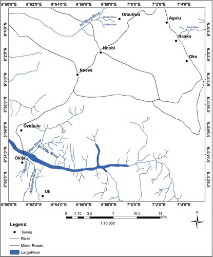
The estimated average widths, depths, flow directions and elevations of the recorded surface water networks are presented in . The surface water networks have depths in the range of 0.8–8.0 m, widths range of 8–55 m. Most of the surface water networks flow in westward direction (). This confirms that they are tributaries to the Niger River. It was observed that some of the gullies in the study area already have depths laterally on the close-ranged elevations with some of the surface water bodies. This suggests that there could be close interactions between the surface water networks and the ground-water. This may be contributory to the high erosivity of the weak, loose and dispersible soils underlying the study area.
Table 1. The surface water distribution and measurements
Groundwater level and flow directions
The VES and ADMT results obtained from the geoelectric surveys are presented in respectively. The VES models (), which are, respectively, validated by the ADMT models (), delineated the groundwater levels and aided in modeling of the hydrostratigraphic successions around the major gullies in the area. The VES curves are majorly the k-type, which usually indicates saturated zones. The heights of the water tables ranged from 9–60 m. reveal that the major kicks on the curves represent zones of saturation. The minor kicks are inferred to be intercalations of clay and sand, with little or no saturation. Since the ADMT measures in mV, it is therefore factual to say that water saturation increases with increasing mV.
Table 2. Interpretation of the resistivity data (Based on Elkhedr, Mohamed, Ahmed, & Laust, Citation2004; Loke, Citation1999; Telford, Gilbert, & Sheriff, Citation1977)
Table 3. The ADMT values
Figure 3. The VES models for the four stations
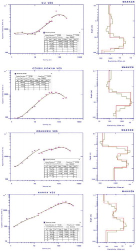
Figure 4. The ADMT models for the stations
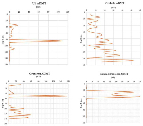
Both the VES and ADMT models show that the study area is generally characterized by shallow water tables. It is believed that the abundance of surface water bodies influences the shallowness of the groundwater tables. This is because the abundance of surface water networks and the shallow depth to groundwater table suggest that recharge and discharge mechanisms are likely working in collaboration in the area. As a result of close interactions between the recharge and discharge mechanisms, it is believed that the groundwater hydrology works in conjunction with the surface water hydrology to accelerate the gullying processes in the study area (Egboka & Nwankwor, Citation1985). , also revealed that the distances between the groundwater and the surface water bodies at the various major gully sites are at close proximity. This suggests that the influence of hydraulic activities would continue impacting on the gullying processes in the area.
Table 4. Analyzed geotechnical properties of the soils
is a model correlating the various aquiferous layers of the different formations (Igwe, Citation2017). It was observed that the groundwater flows in the westward direction. This confirms the result from the study on surface water flow directions () and indicates that topography influences the groundwater flow in the area. The VES for Nanka-Ekwulobia and Oraukwu indicated that they have their uppermost aquiferous layers as perched aquifers (). This suggests that there could be the presence of aquitard inhibiting further vertical flow of water into subsequent aquiferous layers. During the field survey, the shallowness of groundwater was confirmed in the Nanka gully complex as water was observed dripping from some sand overburdens. The water dripping from these sand bodies initiates sheet and rill erosions.
Figure 5. Model showing the aquiferous layers
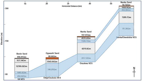
In addition, further reveals that Oraukwu and Nanka-Ekwulobia have higher elevations. This matched the field observation. These areas have higher gullying intensity than those (Uli and Okija-Ozubulu) situated at lower topography. In other words, soil erosion is severe in the northeastern part of the study area (underlain by the Nanka Formation) than in the western part (underlain by the Ogwashi and Benin formations). Hence, it is believed that the high topography, westward flow of the water systems, and the shallowness of the groundwater table in the Nanka Formation play a significant role in the high gullying intensity in the area.
Geotechnical properties of the soils
Results from the geotechnical analysis are presented in . It was observed that the soils underlying three of the sampled gullies have mostly sand composition (in the range of about 68.06% to 86.27%), with little binders (clays). This is consistent with what previous researches carried out in the region reported (Chikwelu & Ogbuagu, Citation2014; Egbueri et al., Citation2017; Igwe & Egbueri, Citation2018; Obiadi et al., Citation2014). However, the gully at Okija-Ozubulu area has grains typical of gravel sizes. In this sample, the gravel composition was observed to be about 83.38% whereas sand constitutes about 11.47% (). With respect to the low fines content in all the soils, they are said to be vulnerable to erosive agents. The moisture content of the soils shows that they were not saturated. This could be due to the low fines content. Fines, which are mostly composed of clays, have higher water retention capacity than sands and gravels (Bell, Citation2007).
The permeability coefficients revealed that the soils are permeable (Igwe et al., Citation2013). Nevertheless, the order of permeability of the soils is: Oraukwu > Okija-Ozubulu > Nanka > Uli. This order is consistent with their respective USCS descriptions (). Hence, the hydraulic conductivity of SW > GP > SC (Egbueri et al., Citation2017). Permeable soils often have high infiltration rate (Bell, Citation2007). Based on the soils’ inferred high infiltration capacity and their hydraulic conductivity, the water regime is believed to contribute to build up of pore water pressure and the erosion through liquefaction of the basal sand units (Bell, Citation2007; Egbueri et al., Citation2017; Igwe, Citation2015, Citation2017). In such a scenario, the effective stress of the soils drastically reduces, leading to the spontaneous collapse of overlying soil units could occur. This failure mechanism thereby continuously accelerates the rate of deepening and widening of these gullies. Because the area experiences heavy rainstorms, shallow landslides on steep slopes could also be a contributory factor to the gully expansion (Acharya, Cochrane, Davies, & Bowman, Citation2011). Moreover, where there are many surface drainage networks and badlands, the washing out of sediments degraded by mass wasting processes would be readily facilitated.
The shear strength results () showed that the soils are weak and possess poor erosion-resistant properties. The low cohesion of the soils is also attributed to their low fines contents. Furthermore, the angle of shearing resistance can be drastically reduced due to rainfall infiltration, thus further exposing the soils to mass wasting and erosion. Research has shown that the erosivity of rainfall is very crucial in predicting water erosion (Laker, Citation2004). According to Mahmood et al. (Citation2016), rainfall infiltration (which often leads to saturation) increases the height of water table and decreases the unsaturated shear strength of soils, due to reduction in matric suction as the wetting front moves through it.
Geomorphological characteristics
Slope gradient
Field observations and measurements of the gully slopes showed that majority of the gully slopes in the area have angle of inclination >30° (), predisposing the soils to influence of denudation agents such as landsliding. According to Igwe (Citation2017), an increase in soil slope steepness may be controlled by drainage density. Out of the six gullies studied, it was observed that those (Oraukwu, Nanka and Ekwulobia) gullies within the Nanka Formation are more vulnerable to erosion, with respect to slope angle. Gullies with steeper slopes have higher erodibility potentials than flat ones. This is because the velocity and erosive impact of surface runoff tend to increase in steeper slopes (Igwe, Citation2015; Igwe et al., Citation2013). shows that Oraukwu, Nanka and Ekwulobia towns are situated on higher elevations than those towns underlain by the Benin and Ogwashi formations. This could be one of the reasons the rate of erosion is severe in the Nanka Formation than in other formations (). With increasing sediment loss, the groundwater height becomes much shallower.
Table 5. The gully slope components
Figure 6. 2D, 3D maps showing the topography of the area
Slope aspect and curvature
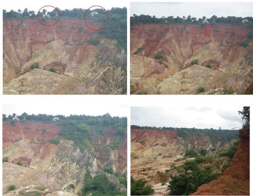
Field measurements showed that the slope directions are generally different, with directions ranging from north, east, south, to west (). Moreover, it was observed that gully slopes having the same direction with the general (westward) flow direction of the surface waters appear to be more vulnerable to erosion. Furthermore, field observations revealed that these gullies are predominated with slopes that have negative curvature configuration (i.e. concave in outlook) (). Across the study area, only few slopes have convex curvatures. Concave slopes are predominant in the Nanka, Ekwulobia and Oraukwu gullies and these slopes have the highest concentration of slide scars. Generally, concave slopes have the tendency to retain more water and a reduced rate of water drainage. The higher the volume of water in a soil slope, the higher its load and the weaker it becomes. In addition, during the field mapping, it was observed that many of gully slopes have tension cracks. These lines of weaknesses were identified as potential sliding surfaces.
Figure 7. Various slope outlooks at Nanka-Ekwulobia gullies. Red circles and arrows show building structures at the verge of collapse
Gullying intensity
presents the measured and estimated average widths, depths, and lateral extents of the major gullies. Results from the gully attribute estimation revealed that gullying intensity is more in areas underlain by the Nanka Formation, while those areas underlain by the Ogwashi and Benin formations have relatively low gullying intensity. The reason for this observed variation could be because of the topography, geotechnical composition of the soils, landuse, and vegetation cover (Chikwelu & Ogbuagu, Citation2014; Igwe, Citation2012; Igwe & Egbueri, Citation2018). It was observed that the topography and slope gradient of the areas underlain by the Nanka Formation are relatively high with average elevation value of 240 m which ranges from 150 to 300 m, and mean slope value of 60° which ranges from 30° to 85° (). Conversely, the topography of the areas underlain by the Ogwashi and Benin formations is relatively low with average elevation values of 48 m which ranges from 40 to 55 m, and gentle-low slope gradients with mean value of 28° that ranges from 18° to 50° (). Topography of an area have been attributed as one of the major factors which controls the rate of soil erosion (Emeh & Igwe, Citation2017; Igwe, Citation2015; Igwe & Egbueri, Citation2018; Igwe et al., Citation2013; Okoyeh et al., Citation2014).
Table 6. Gully attributes and intensity measurements
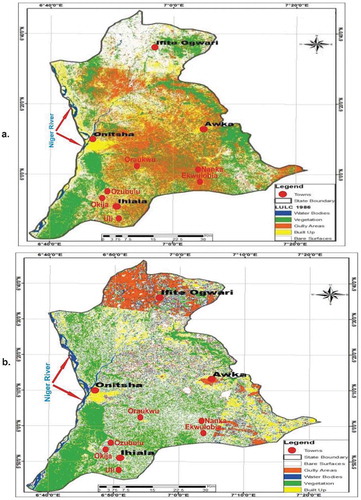
In conjunction with the topography of the area, the geotechnical properties of the soils derived from the Nanka Formation have been ascribed to be relatively poor compared with those of the Ogwashi and Benin formations (Chikwelu & Ogbuagu, Citation2014; Igwe & Egbueri, Citation2018). Results from field mapping also revealed a relatively high landuse in areas underlain by Nanka Formation compared with those of Ogwashi and Benin formations (). This evidence is revealed by the high-population density and high anthropogenic activities (such as inadequate road and drainage system constructions, soil quarrying, disposal of solid wastes into drainage channels) around Oraukwu, Nanka and Ekwulobia towns which are all underlain by the friable Nanka Formation. The data for population distribution in these towns are not known. However, field observation suggests that the population density and the anthropogenic activities were relatively low in towns (Uli, Okija, and Ozubulu) underlain by the Benin and Ogwashi formations. The variation in population density is almost inversely proportional to the vegetation cover, with areas noted for high population density having low vegetation cover (). Researchers have reported that soils become more exposed to erosion when there is poor vegetation cover (Emeh & Igwe, Citation2017; Igwe & Egbueri, Citation2018; Igbokwe et al., Citation2008; Okoyeh et al., Citation2014).
Figure 8. Land use/land cover maps for (a) 1986 and (b) 2013 (modified after Ifeka & Akinbobola, Citation2015)
Conclusions
Based on the research findings, the following conclusions are made:
The study area is characterized with numerous surface water bodies and shallow groundwater systems. These attributes are believed to influence the development and expansion of gullies in the area. Both the surface waters and groundwaters in the study area have a westward flow direction, from areas of high elevations on the Nanka Formation to areas of low elevations on the Ogwashi and Benin formations.
The geotechnical properties of the soils from the three formations revealed that they are very permeable, weak, easily dispersible and collapsible.
The study area is characterized by uneven badland topography, high gully slope gradients (dominantly > 30°), concave slopes, poor land-use practices, and poor land cover.
Hydrogeomorphology and soil engineering properties substantially influence the gullying processes in the area. However, the Nanka Formation has higher gullying intensity than the Ogwashi and Benin formations due to variations in hydrogeomorphological characteristics. It is indicated that with increasing rainfall and infiltration intensity, the impacts of the studied attributes could be more severe.
Recommendation
This paper is only a preliminary effort to spotlight the influence of various hydrologic and geomorphic characteristics on the gullying processes in the study area. It does not present an exhaustive report on the hydrogeomorphologic attributes pertinent to these gullies. Therefore, the authors recommend that further hydrogeomorphological studies, including the use of remote sensing, advanced GIS, soil loss modeling, and soil water characteristics modeling, etc., be conducted in order to enhance this study and deepen the understanding of the dominant component factors in the erosion processes. This will foster the generation of newer, better, and effective mitigation measures for the gully erosion menace in the area.
Declaration statement
The authors declare no potential conflict of interest regarding this paper.
Acknowledgments
The authors are grateful to the GEOCOGCUN Solutions for funding this project. They are also very grateful to the reviewers and editors that helped improve the manuscript.
Additional information
Funding
References
- Acharya, G., Cochrane, T., Davies, T., & Bowman, E. (2011). Quantifying and modeling post-failure sediment yields from laboratory-scale soil erosion and shallow landslide experiments with silty loess. Geomorphology, 129, 49–58.
- Akpan, A. E., George, N. J., & George, A. M. (2009). Geophysical investigation of some prominent gully erosion sites in Calabar, southeastern Nigeria and its implications to hazard prevention. Disaster Advances, 2, 46–50.
- Bell, F. G. (2007). Engineering Geology (2nd ed.). Oxford UK: Butterworth-Heinemann, Elsevier Ltd, 593p.
- Chikwelu, E. E., & Ogbuagu, F. U. (2014). Geotechnical Investigation of Soil around Mbaukwu Gully Erosion Sites, South-Eastern Part of Nigeria. JAGG, 2(4), 6–17.
- Crozier, M. J. (1984). Field assessment of slope instability. In D. Brunsden & D. Prior (Eds.), slope instability. New York: Wiley. p. 620
- Egboka, B. C. E., & Nwankwor, G. I. (1985). Hydrogeological and geotechnical parameters as agents for gully-type erosion in the rain-forest belt of Nigeria. Journal of African Earth Sciences, 3(4). 417–425.
- Egboka, B. C. E., Nwankwor, G. I., & Orajaka, I. P. (1990). Implications of paleo-and neotectonics in gully Erosion prone area of south eastern Nigeria. Natural Hazards Journal, 3, 219–231.
- Egbueri, J. C., Igwe, O., & Nnamani, C. H. (2017). Assessment of the engineering properties and suitability of some tropical soils as backfill materials. International Journal of Trends in Scientific Research and Development, 2(1), 590–605.
- Elkhedr, H. I., Mohamed, R. S., Ahmed, A. E., & Laust, B. P. N. (2004). Geoelectric study on Quaternary groundwater aquifers in Northwest Sinai, Egypt. Egyptian Geophysical Society Journal, 2, 111–125.
- Emeh, C., & Igwe, O. (2018). Effect of environmental pollution on susceptibility of sesquioxide-rich soils to water erosion. Geology, Ecology, and Landscapes, 2, 115–126.
- Emeh, C. O., & Igwe, O. (2017). Variations in soils derived from an erodible sandstone formation and factors controlling their susceptibility to erosion and landslide. Journal of the Geological Society of India, 90(3), 362–370.
- Eze, H. I. (2007). Effect of rain fall intensity and energy on gully development in North eastern Enugu state, Nigeria. Nigerian Journal of Technology, 26(1), 91–96.
- Highland, L. M., & Bobrowsky, P. (2008). The landslide handbook: a guide to understanding landslides. US Geological Survey, Circular 1325 (pp.129). Reston: US Geological Survey
- Ifeka, A. C., & Akinbobola, A. (2015). Land use/land cover change detection in some selected stations in Anambra State. JGRP, 8(1), 1–11.
- Igbokwe, J. I., Akinyede, J. O. B., Dang, B. T., Alaga, T. M. N., Ono, M. N., Nnodu, V. C., & Anike, L. O. (2008). Mapping and monitoring of the impact of gully erosion in southeastern Nigeria with satellite remote sensing and geographic information system. The International Archives of the Photogrammetry. Remote Sensing and Spatial Information Sciences, 37, 865–871.
- Igwe, C. A. (2012). Gully erosion in southeastern Nigeria: Role of soil properties and environmental factors. InTech. Research on Soil Erosion, G. Danilo, Ed. doi: 10.5772/51020
- Igwe, O. (2015). Predisposing factors and the mechanisms of rainfall-induced slope movements in Ugwueme, South-East Nigeria. Bulletin of Engineering Geology and the Environment. doi:10.1007/s10064-015-0767-0
- Igwe, O. (2017). The hydrogeological attributes and mechanisms of a receding sedimentary terrain in the Anambra Basin, Southern Nigeria. Environmental Earth Sciences, 76(1), 1–22.
- Igwe, O., & Egbueri, J. C. (2018). The characteristics and the erodibility potentials of soils from different geologic formations in Anambra State, Southeastern Nigeria. Journal of the Geological Society of India, 92(4), 471–478.
- Igwe, O., Mode, W., Nnebedum, O., Okonkwo, I., & Oha, I. (2013). The analysis of rainfall-induced slope failures at Iva Valley area of Enugu State, Nigeria. Environmental Earth Sciences. doi:10.1007/s12665-013-2647-x
- Kalinski, M. E. (2011). Soil Mechanics Lab Manual (2nd ed., pp. 193). USA: Wiley.
- Laker, M. C. (2004). Advances in soil erosion, soil conservation, land suitability evaluation and land use planning research in South Africa, 1978–2003. South African Journal of Plant and Soil, 21(5), 345–368.
- Loke, M. H. (1999). Electrical Imaging Surveys for Environmental and Engineering Studies: A practical guide to 2D and 3D surveys. Penang, Malaysia.
- Mahmood, K., Kim, J. M., Ashraf, M., & Ziaurrehman, Z. (2016). The effect of soil type on matric suction and stability of unsaturated slope under uniform rainfall. KSCE Journal of Civil Engineering, 20(4), 1294–1299.
- Moges, A., & Holden, N. M. (2008). Estimating the rate and consequences of gully development: A case study of Umbulo catchment in southern Ethiopia. Land Degradation and Development, 19, 574–586.
- Nwajide, C. S. (1992). Gullying in the Idemilli river catchment, Anambra site, Nigeria: Theory and cure. In S. J. Freeth, C. O. Ofoegbu, & K. M. Onuoha (Eds.), Natural hazards in West and Central Africa (pp. 149–162). Wiesbaden: Vieweg.
- Nwajide, C. S. (2013). Geology of Nigeria’s Sedimentary Basins. Lagos Nigeria: CSS Bookshops Limited.
- Nwajide, S. C. (1979). A lithostratigraphic analysis of the Nanka sands of southeastern Nigeria. Journal of Mining and Geology, 16(2), 103–109.
- Obi, G. C., Okogbue, C. O., & Nwajide, C. S. (2001). Evolution of the Enugu Cuesta: A tectonically driven erosional process. Global Journal of Pure and Applied Sciences, 7, 321–330.
- Obiadi, I. I., Nwosu, C. M., Ajaegwu, N. E., Anakwuba, E. K., Onuigbo, N. E., Akpunonu, E. O., & Ezim, O. E. (2014). Gully Erosion in Anambra State, South East Nigeria: Issues and solution. IJES, 2(2), 796–804.
- Ofomata, G. E. K. (1965). Factors of soil erosion in the Enugu area of Nigeria. Nigerian Geographical Journal, 8, 45–59.
- Ofomata, G. E. K. (1988). The management of soil erosion problems in southeastern Nigeria. Proc. Int. Symp. on erosion in S.E. Nigeria. pp.3–12.
- Ogbukagu, I. N. (1979). Soil erosion in the northern parts of the Awka-Orlu uplands. Nigerian Journal of Mining and Geology, 13, 1–6.
- Okoyeh, E. I., Akpan, A. E., Egboka, B. C. E., & Okeke, H. I. (2014). An assessment of the influences of surface and subsurface water level dynamics in the development of Gullies in Anambra State, Southeastern Nigeria. Earth Interactions, 18, 1–24.
- Ownegh, M., & Nohtani, M. (2004). Relationship between Geomorphologic Units and Erosion and Sediment Yield in Kashidar Watershed, Golestan Province, Iran. Conference Paper, 13th International Soil Conservation Organisation Conference – Brisbane, July 2004; Conserving Soil and Water for Society: Sharing Solutions, 5p.
- Poesen, J. (2011). Challenges in gully erosion research. Landform Analysis, 17, 5–9.
- Rockwell, D. L. (2002). The influence of groundwater on surface flow erosion processes during a rainstorm. Earth Surface Processes and Landforms, 27(5), 495–514.
- Roy, K. K., & Elliot, H. M. (1981). Some observations regarding depth of exploration in DC electrical methods. Geoexploration, 19, 1–13.
- Scheidegger, A. E. (1973). Hydrogeomorphology. Journal of Hydrology, 20(3), 193–215.
- Shellberg, J. P., Brooks, A. P., Sencer, J. R., & Ward, D. P. (2013). The hydrogeomorphic influences on alluvial gully erosion along the Mitchell River fluvial megafan. Hydrological Processes, 27(7), 1086–1104.
- Singh, K. P. (2005). Nonlinear estimation of aquifer parameters from surfacial resistivity measurements. Hydrology and Earth System Sciences Discussion, 2, 917–938.
- Sophocleous, M. (2002). Interactions between groundwater and surface water: The state of the science. Hydrogeology Journal, 10, 52–67.
- Tebebu, T. Y., Abiy, A. Z., Zegeye, A. D., Dahlke, H. E., Easton, Z. M., Tilahun, S. A., … & Steenhuis, T. S. (2010). Surface and subsurface flow effect on permanent gully formation and upland erosion near Lake Tana in the northern highlands of Ethiopia. Hydrology and Earth System Sciences Discussion, 7, 5235–5265.
- Telford, W. H., Gilbert, L. P., & Sheriff, R. E. (1977). Applied geophysics. London: Cambridge University Press.