
ABSTRACT
Stream sediments play a significant role in geochemical exploration by identifying possible sources of anomalous element concentration. In this study, we use a multi-element association analysis to investigate the concentration of gold and associated elements in stream sediment samples from the Tchangue-Bikoui drainage area, Southern Cameroon. The main river and its tributaries were sampled, panned for gold grain recovery and the 100 μm size fractions analyzed for Au and associated elements by inductively coupled plasma atomic emission spectrometry (ICP-AES). A total of 50 samples were collected defining an area of ~145 km2 and 20 samples selected for geochemical analysis for a suite of 20 elements. Gold grades estimated by the panning and weighing technique rarely exceed 0.45 g/t and generally erratic while the Au concentrations from chemical analysis range from 0.01ppb to 4.00ppb. R-mode factor analysis produced a five-factor model accounting for 62.4% of the total variance. The Ni-Au-V-Sr association indicated gold mineralization while the others reflect lithologic control. Mo-Cr-Hg-Ag-As-Zr and Pb-Cu show no spatial relationship to Au and point to a typical primary mesothermal sulphide mineralization in the area which can be further investigated. Anomalous gold concentrations clustered mostly in the southeastern part downstream of River Tchangue defining a potential primary gold target.
1. Introduction
Government agencies and mining companies commonly use drainage sediment geochemistry for evaluating the mineral resources over a large area based on the premise that the sediment chemistry and mineralogy reflect the bedrock and surficial geology of the drainage catchment area upstream from the sample site (Marjoribanks, Citation2010). In the guidelines for such survey, it is usually specified that active sediments (i.e., sediments in the process of being transported by the stream) should be sampled (Fletcher, Citation1990; Mimba et al., Citation2014). Obtaining maximum efficiency from a geochemical exploration program necessitates a balance between minimizing the density of sampling and/or maximizing the length of the detectable dispersion trains and significantly reducing the cost and/or time requirements (Cohen, Dunlop, & Rose, Citation2005). Even when care is taken to obtain representative samples, gold explorations can vary markedly as a result of varying hydraulic processes in the stream and the different responses of high- to low-density minerals during transport (Nichols, Hale, & Fletcher, Citation1994). The sedimentological behavior of gold is thus relevant to the design and interpretation of stream sediment and heavy mineral survey for gold as the erosion (start) or deposition (motion) of free gold particles on the bed of a stream are under different conditions as opposed to the rest of the sediments. In exploring for gold using stream sediments, it is, therefore, more effective to analyse for the spatial distribution of a suite of elements than simply looking at gold alone (Ali, Cheng, Wenchang, & Yongqing, Citation2006; Embui, Omang, Che, Nforba, & Suh, Citation2013; Suh, Lehmann, & Mafany, Citation2006). Gold usually occurs in association with other elements such as Cu, As, Zn, Fe, Pb, W (where the gold is associated with chalcopyrite, arsenopyrite, sphalerite, pyrite, galena, and scheelite, respectively, in hydrothermal veins).
Systematic collection and analysis of drainage samples have been established as a method of mineral exploration at both the reconnaissance and detailed scales in many parts of the earth. Stream sediments have been successfully used in many prospecting projects during recent years in Africa (Salminen, Kashabano, Myumbilwa, Petro, & Partanen, Citation2008). Exploration companies, in particular, often use regional-scale stream sediment geochemistry. Multivariate data analysis (e.g., factor analysis, cluster analysis, and correlation analysis together with two-dimensional single element point symbol maps for elemental spatial distribution display) (Harris, Wilkinson, & Grunsky, Citation2000; Xu & Cheng, Citation2001; Grunsky, Citation2002, Citation2010; Yilmaz, Citation2007; Salminen et al., Citation2008; Cheng et al., Citation2011; Embui et al., Citation2013; Mimba et al., 2014; Ghadimi, Ghomi, & Sedigh, Citation2016) and multifractal models (Carranza Citation2009, Citation2010) have been successfully used to analyze stream sediment geochemical data to identify threshold values.
Stream sediment geochemistry for gold prospection has received little attention in Cameroon in the past decade even though there is a growing interest in gold exploration for both junior exploration companies and artisanal miners. Early works on gold mineralization focused on the alteration and gold grade variation in wall rock in the Lom Series (Freyssinet, Lecompte, & Edimo, Citation1989), the morphology and microchemistry of gold grains (Suh & Lehmann, Citation2003), hydrothermal vein mineralization (Suh et al., Citation2006), as well as geophysical delineation of favourable host structures (Fon, Che, & Suh, Citation2012). Recent works on stream sediment geochemistry survey targeted the Viamba-Lidi drainage system in the north of Cameroon (Embui et al., Citation2013), stream sediment reconnaissance survey for gold in the Upper Lom Basin in East Cameroon (Benjamin, Che, Fon, Embui, & Suh, Citation2014) and within the Nyong series of the Southeastern part of Cameroon (Soh et al., Citation2014 and Mimba et al., 2014) reported on the stream sediment survey for gold and REE at Gouap-Nkollo and Ngovayang areas, respectively.
It is worth mentioning that early alluvial gold exploitation in Cameroon started in the 1940s and continues to date although records of the output of such activities are lacking. Most of the alluvial gold workings in Cameroon are located in the Lom Basin (Betare-Oya District) and extending south of it to Batouri District. By 1951, a total of 2256 kg of gold in this area had been produced mainly from alluvial workings (Suh et al., Citation2006). Production records after 1951 are not available because small-scale miners kept no records of output. Recently minor or less active alluvial gold mining operations have been reported (Soh et al., Citation2014; Mimba et al., 2014) in the southern and southeastern Cameroun, respectively, around Eseka, Akom II, and Mintom areas, but little or no exploration works have been carried out in these areas and as such no record of gold production. With the growing interest in gold mineralization in the Southern part of Cameroon by private companies, this work was undertaken in an area where Geocam Mining Sarl has exclusive rights.
Gold is commonly found associated with iron ore deposits. Gold deposits have been reported to be hosted in Banded Iron Formations (BIF) (Cabral, Rocha Filho, & Jones, Citation2003; Oberthür, Saagar, & Tomschi, Citation1990) and the Au maybe occur as free grains (Cabral, Lehman, Kwitko-Ribeiro, & Crave Costa, Citation2002; Cabral et al., Citation2003), occasionally healing micro-fractures (Kwitko-Ribeiro et al., Citation2002) or associated with sulfides as small inclusions (Oberthür et al., Citation1990). The area of study is found with an iron (BIF) rich area as reported by Ganno et al. (Citation2017). Since the region is intensely covered with thick soil, and rocks are exposed in limited areas, stream sediment and soil geochemistry studies are the most commonly used methods in the exploration of mineral deposits. In this study, the applicability of stream sediment surveys in the exploration of mineral deposits in areas of intense overburden is tested using statistical methods. The purpose of this work was to use multivariate statistical analysis to examine the geochemistry of the stream sediments draining the region, determine the multi-element geochemistry of the heavy mineral concentrates, identify the potential pathfinder elements for gold and produce high-quality element distribution maps to support gold and associated mineral exploration.
In this study we show that areas of a high gold grade determined by the weighing and panning method are different from those determined by bulk sample geochemistry, suggesting that gold might have different source lithologies in the area and occur in different forms. By using multivariate statistics, we also show that Ni, V, and Sr are potential pathfinder elements for gold in the area although the element association Mo-Cr-Hg-Ag-As-Zr and Pb-Cu suggests the presence of sulphide-dominated hydrothermal mineralization in the area. These results of the geochemical sampling and data processing are of more than local significance and are optimal to geological and geomorphological environment of the humid tropical settings.
2. Location of the study area and regional geology
The study area is found in the southwestern part of Cameroon located between 10°23ʹ30” E–10°32ʹ00” E and 2°57ʹ30” N – 4°23ʹ30” N (). This area expands from Ebimimbang, through Bipindi, Embimibang, Nlonkeng, Malomba, Bibole, and Tchangue, covering a surface area of about 145 km2. Boeglin, n.d.am, and Braun (Citation2003) classify the vegetation of the area as the Tropical Rain or Wet Evergreen Forest type owing to the fact that forest is immense, luxuriant with a continuous canopy of leaves that shade the underneath from sunlight. Such vegetation is supported by high daily temperatures, rainfall, and humidity all year as well as less seasonal and diurnal fluctuation. The study area experiences four seasons: the long rainy season (September to December), short rainy season (March to April); long dry season (December to March) and short dry season (July to August). Sporadic rainfall is experienced during the period from July to August (Boeglin et al., Citation2003). The dendritic drainage system is controlled by two major rivers – Tchangue and Bikoui. These two rivers are supplied by small streams that flow within the valleys which in turn are fed by a network of runoffs.
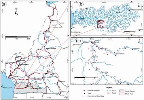
Figure 1. (a) Location map of the study area, Southern Cameroon. (b) Drainage system of the Southern Cameroon. Various streams or tributaries flowing within this basin drain into the Lokoundje River, a major river that drains into the atlantic ocean. The area of study within this basin is the Tchangue-Bikoui drainage system. (c) Sample location map within the Tchangue-Bikoui drainage system. In all 50 samples were collected from active stream sediments.
The Archean Ntem Complex greenstones belt is located within the northern margin of the Congo craton in Cameroon (Maurizot, Abessolo, Feybesse, Johan, & Lecomte, Citation1985; Nédélec, Miyem, & Barbey, Citation1993) (). This complex is a relative block stable of Archean and Palaeoproterozoic rocks surrounded in the north by the Pan-African orogenic belt (Shang, Liégeois, Satir, Frisch, & Nsifa, Citation2010; Tchameni, Merger, Nsifa, & Poclet, Citation2001). The Ntem Complex greenstones belt trends E-W and has been subdivided into three main units, namely, Ayna series to the East, Ntem series to the center and Nyong series to the West. The study area forms part of the Nyong series, which corresponds to the NW border of the Congo Craton. The Nyong series is dominated by biotite-hornblende gneisses, which locally appear as grey gneisses of TTG composition, orthopyroxene-garnet gneisses (charnockites), garnet amphibole-pyroxenites, and banded iron-formation (Ganno, Moudioh, Nzina Nchare, Kouankap Nono, & Nzenti, Citation2015; Lerouge et al., Citation2006; Maurizot et al., Citation1985; Ndema, Ngnotue, Ngo Nlend, Nzenti, & Suh, Citation2014). SHRIMP analysis on detrital zircons from metasediments (BIF) yields Mesoarchaen to Palaeoproterozoic ages with the youngest zircon at 2423 Ma, thus giving the maximum deposition age of the series (Lerouge et al., Citation2006).
Figure 2. Lithostructural map of Cameroon (modified from Caron et al., Citation2010) showing the major structural domains in Cameroon. Red box shows the location of the Tchangue-Bikoui drainage system within the Nyong Paleoproterozoic series, Southern Cameroon.
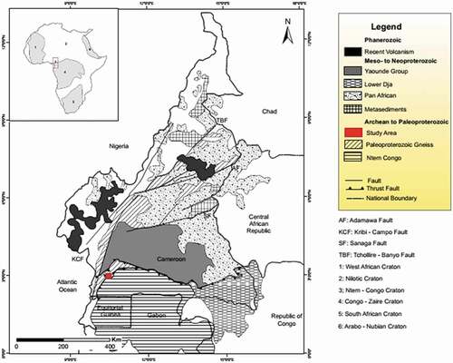
Structurally, the Nyong Series is characterized by the occurrence of N-S sinistral shear zones associated with the Pan-African orogeny (Jégouzo, Citation1984). The formation of these structures was accompanied by high-grade metamorphism (Lerouge et al., Citation2006), and this event dated at 2050 Ma (Toteu, Van Schmus, Penaye, & Nyobé, Citation1994). Cornacchia and Dars (Citation1983), Durmont (Citation1986); and Lerouge et al. (Citation2006) have discussed those fault systems in detail. Based on preserved ages of some metamorphic minerals like titanite and garnet, Penaye et al. (Citation2004) concluded that these structures and the closely associated migmatisation are Paleoproterozoic (ca. 2.05 Ga). In this area, four main lithofacies have been recognized (Ganno et al., Citation2015) namely garnet-biotite gneisses, chlorite-schist, epidote-amphibolite, and metamorphic iron-formations. The latter outcrop as discontinuous lenses in gneiss and amphibolite country rock and form NE-SW trending ridges (Ganno et al., Citation2015). The rocks in this area have experienced three deformation events (Ganno et al., Citation2017). The first deformation event D1 of compressional tectonics is characterized by S1 foliation and β1boudins. The second deformation event D2 is marked by C2 shear planes and F2 folds. The third deformation event D3 is mainly brittle and is responsible for the fractures (veins, joints).
3. Materials and methods of investigation
In the field, stream sediment samples were collected randomly at various points from the bottom of active stream channels using a spade onto stainless steel, flat-bottom conical pan. A total of 50 samples were collected ()) defining an area of ~145 km2. Samples were collected at suitable sites above the confluence point from the first and second-order tributaries as well as from the main Bikoui and Tchangue rivers. The homogenized samples were in situ subdivided into two fractions and weighed. One fraction from each sampling point was then panned and later in the camp gold grains in the dried heavy mineral concentrate were handpicked under a binocular microscope and weighed to obtained Au grade. This gave an indication of the gold grade in each sample and the grade variation thus determined is shown in . The remaining fraction was wet sieved in the field and the fine fraction retained for further laboratory geochemical analysis.
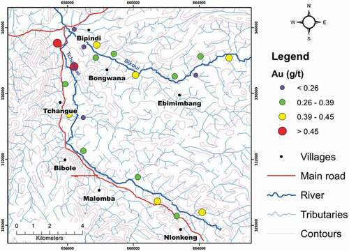
Figure 3. Graduated symbol plot for visible Au by panning and weighing technique (g/t) superimposed on the drainage map of the Tchangue – Bikoui drainage area, South Cameroon. Large red bubbles indicate locations with elevated Au content.
In the laboratory, some trace elements and Au concentrations were determined by inductively coupled plasma atomic emission spectrometry (ICP-AES) using a 2.0 g of each sampled pulp. Samples were digested and analysed following the procedure of Briggs (Citation1996). Samples were digested using a mixture of hydrochloric, nitric, perchloric, and hydrofluoric acids, and the solutions were heated at 110°C until dryness. Additional perchloric acid and water were added to the residue and the mixture was then taken to dryness at 150°C. Aqua regia and dilute nitric acid were added to the residue to bring the solution to a final volume, the solution was heated at 95°C for an hour, and then, after cooling, the sample was aspirated into the argon plasma and element concentrations were determined simultaneously with a multi-channel ICP-AES instrument. Calibration was performed by standardizing with digested rock reference materials and with a series of multi-element solution standards.
Summary statistics of the data set were first calculated to evaluate the distributions. The frequency distribution for each of the elements analysed was examined using histograms, kurtosis, and skewness calculated. Kurtosis and skewness were calculated using the SPSS® program version 16.0. Because the statistical distribution of most variables determined by chemical analyses was not normal, a non-parametric method was used to evaluate the main statistical characteristics of the individual data populations using again the SPSS® program version 16.0. For the purpose of statistical treatment, data from chemical analyses lower than the detection limit were replaced by values equal to 2/5 of the limit of detection. In order to construct contour maps, the data were transformed to a regular grid using the kriging method and results were mapped using the program ArcGIS version 10.2.
Logarithmic data were processed by means of R-mode factor analysis (FA), applying the varimax-raw rotational technique. As a multivariate method, it facilitates the reduction, transformation, and organization of the original data by the use of intricate mathematical techniques, which eventually results in a simple form of the factor model. Factor analysis using the same amount of information creates a new set of uncorrelated variables which are the linear combinations of the original ones. If the original variables have significant linear intercorrelations, when the FA is carried out the first few factors will include the largest part of the total variance. The interpretation of dominant factors was made by taking into account the highest factor loadings for each of the chemical elements. The theoretical details of FA are given by Johnson (Citation1998). The statistical analysis was carried out using the program SPSS® version 16.0.
4. Results and discussion
4.1 Gold grade variation from panning and weighing technique
Graduated symbol plot for visible Au by panning and weighing technique (g/t) overlain on the drainage map of the study area is shown in . Large red bubbles indicate locations with elevated Au content. The point symbol map or spatial plot () shows this variation with the relatively higher Au concentrations found in the headwater areas of river Tchangue which flows from east to west (). The grade decreases downstream along this river () away from the catchment area. All gold grades for samples collected along the Bikoui River and its principal tributaries were below 0.45 g/t with three sampling points showing grades in the range 0.39–0.45 g/t ().
The gold grades estimated by weighing picked gold grains are generally low and erratic and only a few values exceed 0.45 g/t (). The issue of sporadic and erratic gold grade values in various size fractions is a major challenge in stream sediment studies applied to gold exploration (Embui et al., Citation2013; Omang, Che, Fon, Embui, & Suh, Citation2014). Fletcher and Muda (Citation2005) concluded that low Au values in different size fractions often occur at the same sites and the pattern of coincident lows and highs in different size fractions would be unlikely to occur solely as a consequence of random subsampling. Bheemalingeswara (Citation2010) in his work equally noticed that there was a better contrast for gold achieved in bulk (0.59 mm) compared to finer fractions. The observed variation in the gold grade from the panning methods and geochemical analysis of the sediments by ICP-AES might indicate that gold in these sediments is coarse-grained (nuggets) and may also indicate that more than one form of primary gold mineralization exists in the region.
4.2 Geochemistry
Basic statistical parameters that were determined on the basis of chemical analyses of 20 stream sediments samples are reported in . A suite of 20 elements (Au, Ag, As, Ba, Co, Cu, Cr, Hg, Ni, Y, Zr, V, Sc, Sr, Rb, Hr, and Zn) were analyzed by ICP-AES. Au concentration in sampled sediments ranges from 0.01ppb to 4.00ppb. Median and arithmetic mean for the samples are considerably different from each other and this indicates a log-normal distribution. The other elements also show a log-normal distribution like Au and have high anomaly contrasts. Ag concentrations of the samples are between 0.002ppm and 0.64ppm with an arithmetic mean of 0.09ppm. Ag log-normal frequency distribution reveals a positively skewed distribution. Skewness and kurtosis coefficients of data for Ag are considerably higher when compared to those of other elements. Other elements like Ba and Sb which show slightly high skewness and kurtosis coefficients are concluded to be due to the presence of two mineralization phases for those elements.
Table 1. Basic statistical parameters for stream sediment geochemical data obtained from the study area
Elements that accompany Au in the studied stream sediment samples were also investigated using correlation to check for inter-element relationship. Pearson correlation analysis was performed for all the variables. From the correlation analysis (), Au shows a high correlation only with Sr (r = 0.453), weak correlation with V (r = 0.335) and very low correlation with Co (r = 0.062). Other element pairs with positive r values include Ag-Co, Ba-Hg, Y-(Ag, Co, Ni), Sc-(Zr, V), Hf-(Ag, Co, Mo), Sr-V, Rb-V, Zn-(Hg, Ni), Mo-(As, Zr, Pb), and Pb-As. Elements with similar behaviors were determined with cluster analysis and these elements were categorized in groups. All these processes were carried out using the program SPSS® which uses element correlations as the base.
Table 2. Pearson’s linear correlation coefficient matrix derived from stream sediment samples
Using factor analysis (FA), complex linear correlations between metal concentrations in the stream sediments were estimated, which enabled the further interpretation of correlations between elements in the surveyed area. Using the logarithmic data, the influence of potential outliers is eliminated or reduced substantially. Individual components of the system belonging to a given factor were defined by a factor matrix after varimax rotation, with those having strong correlation grouped into factors. The identification of factors is based on the dominant influence. Five main factors (with a sum of squares of loading >1) explain 62.4% of the total variance of the dataset ().
Table 3. Main factors (sum of squares of loadings >1) loading, communalities, explained variance and proportion of total variance for stream sediment samples from the Tchangue-Bikoui drainage system, South Cameroon
The factor matrix after varimax rotation of the components () in sediments shows a grouping of Mo, Cr, Hg, Ag, As, and Zr into the first component (F1; accounting for 21.9% of variance), Ni, Au, V, and Sr are grouped into the second component (F2; accounting for 16.7% of variance), Ba, Hg and Co are grouped into the third component (F3; accounting for 13.6% of variance), Rb, Zr, Y, Co, Sc, and V in F4 (13.4% variance) and, Pb and Cu in F5 (12.3% variance). The presence of Zr and Sc (both high field strength elements (HFSE)) in F1 and F4 indicates that the host minerals are exclusively heavy phases such as garnet, apatite, monazite, ilmenite, and zircon (Bellehumeur, Marcotte, & Jébrak, Citation1994; Embui et al., Citation2013, Mimba et al., 2014). Those factors indicate the erratic occurrences of phases hosting geochemical signals in the sampling media and allow for the recognition of the geochemical components and the regional phenomena associated with a regional trend (Bellehumeur et al., Citation1994). These minerals are present in the metamorphic rocks and their presence in those factors are interpreted to reflect lithological control and are not associated with Au mineralization (Embui et al., Citation2013). The presence of HFSE is also a strong indication of a granitic source (Chandrajith, Dissanayake, & Tobschall, Citation2001) and their presence, therefore, is related to the weathering of these granitic rocks. The fact that gold is not in this paragenesis might also suggest that this paragenesis represents another sulphidation event that is barren with respect to Au.
Elements commonly found enriched in mesothermal lode gold deposits in metamorphic terrains include Au, Ag, As, Sb, Hg, W, Bi, and Mo (Pirajno, Citation1992). Less commonly, Pb, Zn, and Cu may be present. This compares favorably with the observation from this study as the elements loading in F1 show and thus this indicates a typical primary mesothermal sulphide ± gold mineralization paragenesis (Embui et al., Citation2013). Most of the arsenic in the study area might have been co-precipitated and/or adsorbed by hydrous iron and other oxides or have reacted with cations such as Fe and Cu to give a variety of insoluble arsenates during hydrolytic and colloidal reactions in oxidized zones as suggested by Boyle (Citation1979), Craw (Citation2001) and Bose and Sharma (Citation2002) elsewhere. A similar situation exists for the Ag as well. Positive correlation coefficients between Au and Ag are weak in the stream sediment dataset (r = 0.18, ). These metal associations can only be encountered in epithermal and to a certain extent in mesothermal precious metal deposits (Yilmaz, Citation2007). F1 shows a close association of Au with Ag and to a lesser extent As, as well as close association with Mo, indicating two distinct geochemical signatures that are possibly related to the epi- to meso-thermal precious and base metal mineralization systems in the study area.
F2 and F3 contain the transitional metals (TM) and the large ionic lithophile elements (LILE), Ni, V, and Sr together with Au (). F2 is thus the mineralization factor. It has been shown that Co, Mn, and Ni can substitute for Fe in magnetite (Surour, El-Kammar, Arafa, & Korany, Citation2003), reflecting the receptivity of the octahedral and tetrahedral sites in the spinel lattices. The V present in this factor is explained by its normal occurrence in small amounts in magnetite (Mimba et al., 2014) and its association with Ni represents relation to ultramafic intrusions as well as high-temperature mineralization. The study area is rich in Fe oxides (magnetite) occurring within quartzites and gneisses and Fe is the most important host element for V in magnetite. In a similar study in China, Ali et al. (Citation2006) concluded that the association of Au-As-Hg-Ni-Co could represent gold mineralization related to deep, high-temperature ore-forming processes and in this study area, therefore, Ni, V, and Sr could serve as pathfinders for Au. Within the weathering soil profile of this area, the dispersion of those elements may be investigated to ascertain this role as pathfinders for Au. The absence of Cu, Pb, and Zn in the same factor and the weak to no correlation between Au – Cu (r = −0.07), Pb (r = −0.002), and Zn (r = 0.16) () suggest that Au is free and neither bound chemically to the sulphides nor disseminated as minute inclusions in them. Also, the fact that gold is not found associated with the chalcophile elements supports the idea of placer gold (Dampare et al., Citation2005) whose source though unknown is not generally related to sulphides of the base metals (Mimba et al., 2014). Placer gold mineralization is supported in this study by the observation of gold specks in the panning and weighing method suggesting gold is free. Moreover, artisanal gold exploration targets have been found in the study area and the on-going artisanal mining supports the placer gold mineralization concept. Given that rocks in this area have experienced multiple deformation events (Ganno et al., Citation2017) characterized by faults and fractures associated with folds, it is possible that gold mineralization was probably introduced in the shear zones, evident from the anomalous concentration of Au close to those folds.
F4 comprises Rb, Zr, Y, Co, Sc, and V (). The trace elements content of this factor points to the presence of granitic rocks possibly bearing Pb and Cu sulphide disseminations and thus reflect a lithologic control. These minerals are thus probably produced by the weathering of the basement rock of the study area. The variability of the elements in this factor can thus be concluded as being controlled by the mixed rock types occurring in the area. F5 comprising of Pb and Cu is not deemed to be related to the Au mineralization and is attributed to the weathering of granitic rocks and their subvolcanic equivalents, both with disseminated sulphides such as chalcopyrite (CuFeS2) and galena (PbS). It can also be regarded as a Pb-Cu mineralization factor. Salminen et al. (Citation2008) noted that Cu is mobile particularly at high temperatures. The possibility that Cu fractionated into a fluid phase during magmatism and subsequent hydrothermal activity can account for the segregation of Cu from the other base elements. Consequently, Cu-bearing minerals will be devoid of other essential trace elements. Identifying and distinguishing these two separate sulphidation events may hold the key for further exploration of primary gold in this region.
4.3 Spatial analysis
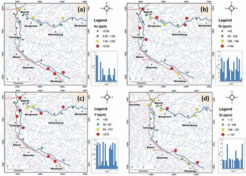
To further enhance the data presentation and interpretation we generated point symbol maps for elements that make up factors 1, 2 and 5 using ArcGIS 10.2 software. The data for each element were then superimposed on the georeferenced drainage map of the study area. Few studies have been done on gold occurrences in the south of Cameroon (Mimba et al., 2014, Soh et al., Citation2014) and recent discoveries of more artisanal mining sites in the area have renewed the interest in gold exploration. In this study area, promising Au exploration targets have been found and restricted to the southeastern part () downstream of the River Tchangue. Indeed, Sr which makes up F2, mimics the Au concentration upstream in this river and along River Bikoui their concentration is a bit erratic. Because the area is characterized by multiple deformation episodes leading to the formation of faults and fractures (Ganno et al., Citation2017) which are associated with folds, the Au mineralization was probably introduced within a shear zone system and this is reflected by the anomalous concentration of Au within the Nlonkeng area which forms part of the Kwambo area as defined by Ganno et al. (Citation2017). The siderophile elements Ni and V, which are potential pathfinders for Au in the area, show a high correlation and spatial association with Au. This implies that Au in this area could be coming from a granitic source. The weak correlation between Au and V, which are commonly associated with heavy minerals, suggests that the spatial distribution of gold downstream is partly controlled by fluvial energy conditions on the stream bed (Fletcher & Muda, Citation2005). This also explains why there is a high concentration in stream sediment at Nlonkeng where the fluvial energy is low (). The fine-grained size of the gold grains in alluvium could be explained by the process of fractionation and partial dissolution of the primary gold grains which favours the increase of fine fraction of the gold as meteoric weathering progresses (Edou Minko, Colin, Trescases, & Lecomte, Citation1992) and this supports the observed gold dust in concentrates from the study area.
Figure 4. Graduated symbol plot for (a) Au (ppb), (b) Ni (ppm), (c) V (ppm) and (d) Sr (ppm) superimposed on the drainage map of the Tchangue – Bikoui drainage area, South Cameroon. High positive scores (large bubbles) indicate locations with anomalous concentrations.
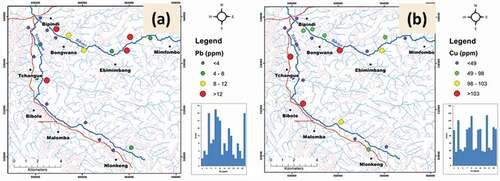
The element association Mo-Cr-Hg-Ag-As-Zr () and Pb-Cu () shows no spatial relationship to Au and the fact that this paragenesis does not contain Au supports the earlier conclusion that this paragenesis represents a sulphidation event that is barren with respect to Au. The development of this association Mo-Cr-Hg-Ag-As-Zr with the addition of W is commonly attributed to the hydrothermal alteration of wall rock (Embui et al., Citation2013) which often results in the formation of scheelite, molybdenite, and arsenopyrite.
Figure 5. Graduated symbol plot for (a) Mo (ppm), (b) Cr (ppm), (c) Hg (ppm), (d) Ag (ppm), (e) As (ppm) and (f) Zr (ppm) superimposed on the drainage map of the Tchangue – Bikoui drainage area, South Cameroon. High positive scores (large bubbles) indicate locations with anomalous concentrations.
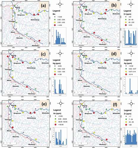
Figure 6. Graduated symbol plot for (a) Pb (ppm) and (b) Cu (ppm) superimposed on the drainage map of the Tchangue – Bikoui drainage area, South Cameroon. High positive scores (large bubbles) indicate locations with anomalous concentrations.
5. Conclusions
This statistical studies and data evaluations show that:
The gold grades estimated by panning and by ICP-AES have high values that are spatially unrelated demonstrating the influence of the nugget effect and that gold occurs in the area as free grains or placer related and as sulphide-related. It is therefore recommended that grain size fraction analysis Vs gold grade should be done so as to minimize the chance of missing erratic Au anomalies.
Multi-element statistical analysis shows a strong association of Au with the siderophile elements Ni and V suggesting that gold is related to ultramafic intrusions as well as deep, high-temperature mineralization event. Those elements Ni, V, and Sr could serve as potential pathfinders for Au in this area and dispersion haloes in soils of the area are recommended be investigated to consider them as pathfinders.
The element associations Mo-Cr-Hg-Ag-As-Zr and Pb-Cu show no spatial relationship to Au and these parageneses are concluded to represent different sulphidation events that are barren with respect to gold and are related to granitic intrusions. Distinguishing these two sulphide formation events is crucial to successful exploration in the region.
Multi-element statistical and spatial analyses have been used to relate the concentration and distribution of elements in the stream sediment samples to lithology and mineralization. The multi-element statistical treatment of the geochemical data permits an appraisal of the Au bearing potential of the area defining a potential target for future exploration in the area. A detailed study on the gold grains microchemistry should be done, so as to get more information on the provenance of the Au deposit.
Acknowledgments
This study was made possible by the interest and authorization of GEOCAM Mining Sarl for granting access to their permit area. Part of the data presented here forms a part of the second author’s M.Sc thesis at the University of Buea, Cameroon.
Disclosure statement
No potential conflict of interest was reported by the authors.
References
- Ali, K., Cheng, Q., Wenchang, L., & Yongqing, C. (2006). Multi-element association analysis of stream sediment geochemistry data for predicting gold deposits in south- central Yunnan Province, China. Geochemistry: Exploration, Environment, Analysis, 6, 341–348.
- Bellehumeur, C., Marcotte, D., & Jébrak, M. (1994). Multielement relationships and spatial structures of regional geochemical data from stream sediments, southwestern Québec, Canada. Journal of Geochemical Exploration, 51(11–35), 11–35.
- Benjamin, O. O., Che, V. B., Fon, A. N., Embui, V. F., & Suh, C. E. (2014). Regional Geochemical Stream Survey for Gold Exploration in the Upper Lom Basin, Eastern Cameroon. International Journal of Geosciences, 5(9). doi:https://doi.org/10.4236/ijg.2014.59087
- Bheemalingeswara, K. (2010). Use of Bulk Sample and Hot Acids in Stream Sediment Survey for Gold. Journal of Earth Science India, 3(II), 115–123. Retrieved from http://www.earthscienceindia.info
- Boeglin, J. L., Ndam, J. R., & Braun, J. J. (2003). Composition of the different reservoir waters in a tropical humid area: Example of the Nsimi catchment (Southern Cameroon). Journal of African Earth Sciences, 37(1–2), 103–110.
- Bose, P., & Sharma, A. (2002). Role of iron in controlling speciation and mobilization of arsenic in subsurface environment. Water Researches, 36(19), 4916–4926.
- Boyle, R. W. (1979). The geochemistry of gold and its deposits. Bulletin Geological Survey Canada, 280, 1–584.
- Briggs, P. H. (1996). Forty elements by inductively coupled plasma-atomic emission spectrometry. In B. F. Arbogast (Ed.), Analytical methods manual for the Mineral Resource Surveys Program (Vols. 96–525, pp. 77–94). U.S.: Geological Survey Open-File Report.
- Cabral, A. R., Lehman, B., Kwitko-Ribeiro, R., & Crave Costa, C. H. (2002). Palladium and Platinum Minerals from the Serra Paleda Au-Pd-Pt deposit, Carajas Mineral Province, Northern Brazil. The Canadian Mineralogist, 40(5), 1451–1463.
- Cabral, A. R., Rocha Filho, G. O., & Jones, D. R. (2003). Hydrothermal origin of soft hematite ore in the Quadrilátero Ferrífero of Minas Gerais, Brazil: Petrographic evidence from the Gongo Soco iron ore deposit. Applied Earth Science IMM Transactions Section B, 112(3), 279–286.
- Caron, V., Ekomane, E., & Mahieux, G., Moussango, P.,& Ndjeng, E.(2010).The Mintom Formation(new): Sedimentology and geochemistry of a Neoproterozoic, Paralic succession in south-east Cameroon. Journal of African Earth Sciences, 57, 367–385. https://doi.org/https://doi.org/10.1016/j.jafrearsci.2009.11.006
- Carranza, E. J. M. (2009). Mapping of anomalies in continuous and discrete fields of Stream sediment geochemical landscapes. Geochemistry: Exploration, Environment, Analysis, 10(2), 171–187.
- Carranza, E. J. M. (2010). Catchment basin modeling of stream sediment anomalies revisited incorporation of EDA and fractal analysis. Geochemistry: Exploration, Environment, Analysis, 10(4), 365–381.
- Chandrajith, R., Dissanayake, C. B., & Tobschall, J. (2001). Application of multi-element relationships in stream sediments to mineral exploration; a case study of Walawe Ganga Basin, Sri Lanka. Applied Geochemistry, 16(3), 339–350.
- Cheng, Q., Bonham-Carter, G. F., Wang, W., Zhang, S., Li, W., & Xia, Q. (2011). A spatial weighted principal component analysis for multi-element geochemical data for mapping locations of felsic intrusions in the Gejiu mineral district of Yunnan, China. Computers and Geosciences, 5, 662–669.
- Cohen, D. R., Dunlop, A. C., & Rose, T. (2005). Contrasting dispersion patterns for gold in stream sediments in Timbarra, NSW, Australia. Journal of Geochemical Exploration, 85(1), 1–16.
- Cornacchia, M., & Dars, R. (1983). Un trait structural majeur de continent Africain. Les linéations centrafricains du Cameroun au golfe d’Aden. Bulletin Société Géologie de France, 7(25), 101–109.
- Craw, D. (2001). Tectonic controls on gold deposits and their environmental impact, New Zealand. Journal of Geochemical Exploration, 73(1), 43–56.
- Dampare, S. B., Nyarko, B. J. B., Osae, S., Akaho, E. H. K., Asiedu, D. K., Serfor-Armah, Y., & Nude, P. (2005). Simultaneous determination of tantalum, niobium, thorium and uranium in placer columbite-tantalite deposits from the Akim-Oda District of Ghana by epithermal instrumental neutron activation analysis. Journal of Radio analytical and Nuclear Chemistry, 265(1), 53–59.
- Durmont, J. (1986). Identification par télédétection de l’accident de la Sanaga (Cameroun). Sa position dans le contexte des grands accidents d’Afrique Central et de la limite nord du craton congolais. Géodynamique, 1, 13–19.
- Edou Minko, A., Colin, F., Trescases, J. J., & Lecomte, P. (1992). Altération latéritique du gite aurifère d’Ovala (Gabon) et formation d’une anomalie superficielle de dispersion. Mineralium Deposita, 27, 90–100.
- Embui, V. F., Omang, B. O., Che, V. B., Nforba, M. T., & Suh, E. C. (2013). Gold grade variation and stream sediment geochemistry of the the Vaimba-Lidi drainage system, northern Cameroon. Natural Science, 5(2A), 282–290.
- Fletcher, W. K. (1990). Dispersion and behavior of gold in stream sediments, A contribution to the Canada/British Columbia Mineral Development Agreement. Open file, 1990.
- Fletcher, W. K., & Muda, J. (2005). Dispersion of gold in stream sediments in the Sungai Kuli region, Sabah, Malaysia. Geochemistry: Exploration, Environment, Analysis, 5, 211–214.
- Fon, A. N., Che, V. B., & Suh, C. E. (2012). Application of electrical resistivity and chargeability data on a GIS platform in delineating auriferous structures in a deeply weathered lateritic terrain, eastern Cameroon. International Journal of Geosciences, 3, 960–971.
- Freyssinet, P. H., Lecompte, P., & Edimo, A. (1989). Dispersion of gold base metals in the Mborguene lateritic profile, east Cameroon. Journal of Geochemical Exploration, 32, 99–116.
- Ganno, S., Moudioh, C., Nzina Nchare, A., Kouankap Nono, G. D., & Nzenti, J. P. (2015). Geochemical fingerprint and iron ore potential of the siliceous itabirite from Palaeoproterozoic Nyong series, Zambi area, Southwestern CameroonResource. Geol, 66(1), 71–80.
- Ganno, S., Njiosseu, T. E. L., Kouankap, N. G. D., Djoukouo, S. A., Moudioh, C., Ngnotué, T., & Nzenti, J. P. (2017). A mixed seawater and hydrothermal origin of superior-type banded iron formation (BIF)-hosted Kouambo iron deposit, Palaeoproterozoic Nyong series, Southwestern Cameroon: Constraints from petrography and geochemistry. Ore Geology Reviews, 80, 860–875.
- Ghadimi, F., Ghomi, M., & Sedigh, M. A. (2016). Identification of Ti-Anomaly in Stream Sediment Geochemistry using Stepwise Factor Analysis and Multifractal Model in Delijan District, Iran. International Journal of Mining and Geological Engineering, 50(1), 77–95.
- Grunsky, E. C. (2002). Statistical analysis in the geosciences. In P. M. Atkinson (Ed.), Encyclopaedia of Life Support Systems (EOLSS). Oxford: EOLSS Publishers.
- Grunsky, E. C. (2010). The interpretation of geochemical survey data. Geochemistry: Exploration, Environment, Analysis, 10, 27–74.
- Harris, J. R., Wilkinson, L., & Grunsky, E. C. (2000). Effective use and interpretation of lithogeochemical data in regional mineral exploration programs; application of geographic information systems (GIS) technology. Ore Geology Reviews, 16, 107–143.
- Jégouzo, P. (1984). Evolution du Sud-Ouest Cameroun pendent l’orogenèse Panafricaine: Association des technique cisaillant et chevauchante. Colloque chevauchement et Déformation, Toulouse, 123.
- Johnson, D. E. (1998). Applied Multivariate Methods for Data Analysis. California: Duxbury Press, Pacific Grove.
- Kwitko-Ribeiro, R., Cabral, A. R., Laflamme, J. H. G., Cabri, L. J., Criddle, A. J., & Galbiatti, H. F. (2002). Hongshiite, Pt-Cu, from Itabarite-Hosted Au-Pd-Pt Mineralization (Jacutinga), Itabira District, Minas Gerais, Brazil. The Canadian Mineralogist, 40(2), 711–723.
- Lerouge, C., Cocherie, A., Toteu, S. F., Penaye, J., Milési, J. P., Tchameni, R., … Doloule, E. (2006). Shrimp U-Pb zircon age evidence for Paleoproterozoic sedimentation and 2.05Ga syntectonic plutonism in the Nyong Group, Southwestern Cameroon: Consequences for the Eburnean-Transamazonian belt of NE Brazil and Central Africa. Journal of African Earth Sciences, 44(4–5), 413–427.
- Marjoribanks, R. (2010). Geological Methods in Mineral Exploration and Mining. Second Edition. Berlin Heidelberg: Springer-Verlag.
- Maurizot, P., Abessolo, A., Feybesse, J. L., Johan, V., & Lecomte, P. (1985). Etude et prospection minière du Sud Ouest Cameroun. Synthèse des travaux de 1978 (BRGM report CMR 066).
- Mumbfu, E. M ., Nforba, M. T., & Suh, C. E. (2014). Geochemical dispersion of gold in stream sediments in the Paleoproterozoic Nyong Series, Southern Cameroon. Science Research 2 (6), 155-165, doi: https://doi.org/10.11648/j.sr.20140206.12
- Mumbfu, E. M., Nforba, M. T., & Suh, C. E. (2014). Geochemical Dispersion of Gold in Stream Sediments in the Paleoproterozoic Nyong Series, Southern Cameroon. Science Research, 2(6), 155–165.
- Ndema, M. J. L., Ngnotue, T., Ngo Nlend, C. D., Nzenti, J. P., & Suh, C. E. (2014). Origin and evolution of the formation of the Cameroon Nyong Series in the western border of the Congo Craton. Journal of Geosciences and Geomatics, 2, 62–75.
- Nédélec, A., Miyem, D., & Barbey, P. (1993). High P-High T anatexis of Archaean tonalite grey gneisses: The Eseka migmatites, Cameroon. Precambrian research, 62(3), 91–205.
- Nichols, I., Hale, M., & Fletcher, W. K. (1994). Drainage geochemistry in gold exploration. In M. Hale & J. A. Plant (Eds.), Drainage Geochemistry, Handbook of Exploration Geochemistry 6 (pp. 499–557). Amsterdam: Elsevier.
- Oberthür, T., Saagar, R., & Tomschi, H. P. (1990). Geological, mineralogical and geochemical aspects of Archaean Banded Iron-Formation-hosted gold deposits: Some examples from Southern Africa. Mineral Deposita, 25, S125–S135.
- Omang, B. O., Che, V. B., Fon, A. N., Embui, V. F., & Suh, C. E. (2014). Regional Geochemical Stream Sediment Survey for Gold Exploration in the Upper Lom Basin, Eastern Cameroon. International Journal of Geosciences, 5(9), 1012–1026.
- Penaye, J., Toteu, S. F., Tchameni, R., Van Schmus, W. R., Tchakounté, J., Ganwa, A., … Nsifa, E. N. (2004). The 2.1Ga West Central African Belt in Cameroon: Extension and evolution. Journal of African Earth Sciences, 31, 159–164.
- Pirajno, F. (1992). Hydrothermal Mineral Deposits. Principles and Fundamental Concepts for the Exploration Geologist (pp. xviii + 709). Berlin, Heidelberg, New York, London, Paris, Tokyo, Hong Kong: Springer-Verlag. doi:https://doi.org/10.1017/S0016756800020392.
- Salminen, R., Kashabano, J., Myumbilwa, Y., Petro, F. N., & Partanen, M. (2008). Indications of deposits of gold and platinum group elements from a regional geochemical stream sediment survey in NW Tanzania. Geochemistry: Exploration, Environment Analysis, 8, 313–322.
- Shang, C. K., Liégeois, J. P., Satir, M., Frisch, W., & Nsifa, E. N. (2010). Late Archaean high-K granite geochronology of the northern metacratonic margin of the Archaean Congo craton, Southern Cameroon: Evidence for Pb-loss due to non-metamorphic causes. Gondwana Research, 18(2–3), 337–355.
- Soh, T. L., Ganno, S., Kouankap, N. G. D., Ngnotue, T., Kankeu, B., & Nzenti, J. P. (2014). Stream Sediment Geochemical Survey of Gouap-Nkollo Prospect, Southern Cameroon: Implications for Gold and LREE Exploration. American Journal of Mining and Metallurgy, 2(1), 8–16.
- Suh, C. E., & Lehmann, B. (2003). Morphology and electron-probe microanalysis of residual gold-grains at Dimako, Southeast Cameroon. Annual Reviews in Mineralogy, 6, 255–275.
- Suh, C. E., Lehmann, B., & Mafany, G. T. (2006). Geology and geochemical aspects of lode gold mineralization at Dimako - Mboscorro, SE Cameroon. Geochemistry: Exploration, Environment, Analysis, 6, 295–309.
- Surour, A. A., El-Kammar, A. A., Arafa, E. H., & Korany, H. M. (2003). Dahab Stream Sediments southeastern Sinai, Egypt: A potential source of gold, magnetite and zircon. Journal of Geochemical Exploration, 7(1), 25–43.
- Tchameni, R., Merger, K., Nsifa, E. N., & Poclet, A. (2001). Crustal origin of early Proterozoic syenites in the Congo Craton (Ntem Complex) southern Cameroon. Lithos, 57(1), 23–42.
- Toteu, S. F., Van Schmus, W. R., Penaye, J., & Nyobé, J. B. (1994). U-Pb and Sm-Nd evidence for Eburnean and PanAfrican high-grade metamorphism in cratonic rocks of southern Cameroon. Precambrian research, 108, 45–73.
- Xu, Y., & Cheng, Q. (2001). A fractal filtering technique for prospecting regional geochemical maps for mineral exploration. Geochemistry: Exploration, Environment, Analysis, 1, 147–156.
- Yilmaz, H. (2007). Stream Sediment Geochemical Exploration for Gold in the Kazdag Dome in the Biga Peninsula, Western Turkey. Turkish Journal of Earth Sciences, 16, 33–55.