
 ?Mathematical formulae have been encoded as MathML and are displayed in this HTML version using MathJax in order to improve their display. Uncheck the box to turn MathJax off. This feature requires Javascript. Click on a formula to zoom.
ABSTRACT
In the high basin of Oum Er Rbia in the Middle Atlas Mountain, the steep slopes with inherent soil lead to the formation of landslides, which could pose danger to road infrastructure and buildings. Evenly the heavy rains exceeding the saturation of soils play a key role in landslides. In this context, this study attempted to assess unconsolidated soil characteristics and their impacts on landslide susceptibility.
The texture, clay mineralogy, and Atterberg limits were determined for soil samples. Atterberg limits were conducted to estimate the swell potential of the soil and eventually classify the soil samples as swelling or non-swelling.
As a result of the geotechnical studies, the average of the liquid limit values was between 28% and 56%, and the mean plasticity index of the units ranged from 13% to 24% in the overlying materials in the landslide zones. XRD analysis revealed that the most dominant mineral identified was quartz; illite minerals.
Introduction
Landslides can be generated by the interaction of several factors such as intense rainfall, seismicity, water level change, storm waves or rapid stream erosion, geology, land cover, slope geometry, groundwater saturation, vegetation cover, and anthropogenic activities (El Jazouli, Barakat et al., Citation2019a, Althuwaynee et al., Citation2014; Sangchini et al., Citation2016). These effects increase the shear stress or decrease the shear strength of materials in the slope. Landslide susceptibility evaluation has become a major concern in mountainous areas, it is a key component of manager policy efforts in disaster prevention, mitigate risk, and manage the consequences (A. J. C. Yalcin, Citation2008, Gioacchino Francesco Andriani, Citation2015, Vakhshoori & Zare, Citation2016). Therefore, the properties of the lithological units are very important for the propensity for landslides. The weathered units act as soil from a mechanical perspective, thus determining the geotechnical properties of the unit necessary (Yalcin, Citation2011).
Water content, consistency limits, grain size distributions, the type of fine-grained lithological units must be determined in relation to landslide behavior. The detailed investigations of the geotechnical properties of the units are a major aspect of the prediction of landslides (Carrière et al., Citation2018). Although only few studies attempted to directly characterize the rheological behavior of clay soils and muds originating from landslides (Coussot et al. Citation1998; Hungr & Picarelli, Citation2014; Malet et al., Citation2005). The characterization of landslides could provide very useful clues in terms of the nature of the slope failure and subsequent debris movement, thus indicating where landslides could potentially happen.
In Morocco, areas prone to landslides are mainly the Rif and to a lesser extent the Middle Atlas because of the existence of very contrasting reliefs, friable geological terrains (clays, flyschs, marls), and rigorous climatic conditions (El Jazouli, Barakat et al., Citation2019b). Hence, the first census, description, and mapping of mass movement phenomena began in the 1960s by Avenard (Citation1965) who mapped erosion in the Sebou basin. Numerous studies based on the physico-chemistry, mineralogy, and geotechnical properties of soil clays provide useful insight into the presence of clays in soils has been associated with landslide occurrence (Daoudi et al., Citation2015; Diko et al., Citation2014; Ekosse et al., Citation2005; Fall & Sarr, Citation2007; Ngole et al., Citation2007; Yalcin, Citation2007, Citation2011).
This study can provide the information to locate safe construction areas in regions that are prone to landslides thus safeguarding lives and property. Therefore, 10 landslides were investigated in Khénifra province. The existence of steep slopes and unconsolidated rocks (clay and marls) represents the main factors affecting landslide (Jazouli, Barakat et al., Citation2019a)
The present work aimed to characterize, to map, to assess selected samples, which seem rich clay from this sedimentary sequence was collected and subjected to a detailed laboratory testing program, including mineralogy (bulk and clay fractions), Atterberg’s limits and particle size distribution, and quantitative analyses by X-ray diffraction (XRD).
Materials and methods
Study area
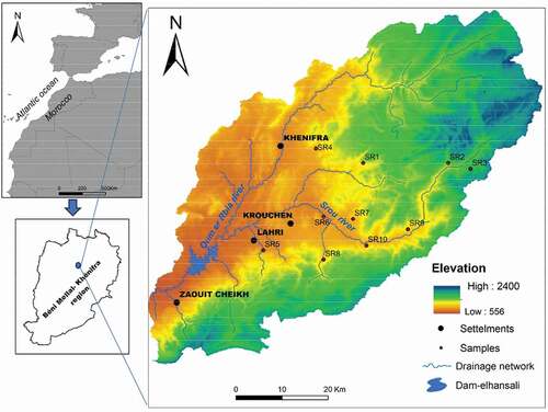
The study area located within Khénifra province, in northern central Morocco. A part of Oum Er Rbia high basin, the study area lies the Middle Atlas Mountain and extended from longitude 5°05′W to 5°50′W and from latitude 32°35′N to 33°00′N (). The studied basin is delimited in the west by the Hercynian Central Massif, to the north by the Causse of Ajdir and by the plain of the High Moulouya to the southeast. It occupies an area of 3612.21 km2. The elevation of the area ranged from 662 to 2400 m. The valleys of rivers with large elevation and steep slopes constitute an area where a strong agricultural activity and rural development take place.
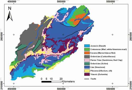
Figure 1. Geological map of study area.
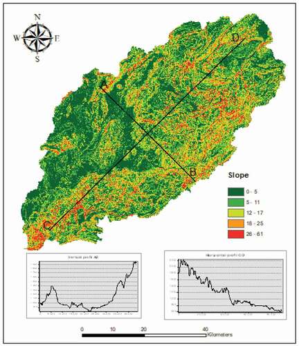
The topography in the study area rises abruptly from the coast. The variations in the slope of hills, mountains, and the rivers extend from north to south direction give this region a rough morphology. The slope angle is directly related to the occurrence of landslide. It is frequently used as the key measure in landslide studies. The slope layer was extracted from DEM. The slope map of the study area was divided into five slope categories: 0–5, 5–11, 12–17, 18–25, and 26–61 () (Jazouli, Barakat et al., 2019).
Figure 2. Study area location.
The climate of Khénifra Province is a continental Mediterranean type mountain. It is characterized by a rainy and cold winter with periods of snow in the high mountains, and a dry and hot summer with stormy periods.
The precipitation regime is seasonal with maximum rain and snow in winter. Annual rainfall varies, depending on the region, between 400 and 700 mm depending on altitude and exposure.
The average temperatures recorded range from a minimum of 4°C (January) to a maximum of 35°C (July–August).
The winter period is characterized by a cold weather. By cons, the summer period appears very hot.
The Middle Atlas consists of secondary limestones with large cyclones and narrow anticlines, low-level dumped to the northwest. The valleys are narrow and deep and have sunk into Triassic gypseous terrains and salifiers. The Triassic, which forms the impervious and continuous substratum of the liasic aquifer. . The Jurassic sedimentary series begins with an alternation of dolomites and red clays, marking the transition from sedimentation dominated by the Upper Triassic to marine sedimentation, which is confirmed at Lias with carbonate deposits. The deposits of the lower Lias are represented by a powerful calcaro-dolomitic formation (Geological map of the upper Basin of the Oum Er Rbia according to the map of Rabat 1/50,000) ().
Soil sampling and analysis methods
Sampling was carried out from Mars to May 2017 period that coincided with dry weather conditions. Ten soil samples were collected from the topsoil to a depth of about 30 cm from the fields potentially at landslide risk, and their coordinates were recorded using Global Positioning System (GPS). The samples collected randomly and put in polythene bags labeled were brought to the laboratory and were air-dried and sealed in clean polyethylene bags.
Geotechnical properties
The clay minerals are hydrated aluminosilicates of the phyllosilicate family. These minerals are the main constituents of the clay rocks and the material obtained from these rocks after a possible refining (Deer et al., Citation1992; Horn, Citation1998; Nesse, Citation2000). The sheet structures of clay minerals influence the physicochemical properties of soil such as cation exchange capacity, plasticity, workability, and refractoriness (Carrière et al., Citation2018; Horn, Citation1998).
Atterberg limits are a basic measure of soil plasticity as a function of moisture variation. Soil plasticity is due to swelling clay minerals; soils without swelling clay minerals are non-plastic (Gourley et al., Citation1993; Mitchell, Citation1993; Thomas et al., Citation2000). Clayey soils behave differently at varying moisture contents; they may appear in a solid, semi-solid, plastic, or semi-liquid state. The boundaries between these four soil states are called Atterberg limits, namely shrinkage limit, plastic limit, and liquid limit (Das, Citation2002). Shrinkage limit (SL) is a boundary between solid and semi-solid states of soil; it is a point where soil will no longer shrink due to drying. Plastic limit (PL) of soil is at a point where soil changes the state from semi-solid to plastic due to increasing water content. Liquid limit (LL) of soil is at a point where soil changes from plastic to liquid state as the water content increases (Das, Citation2002). The liquid limit was carried out with the Casagrande cup. PL test was performed by kneading and rolling soil samples between fingers and thumb into 6 mm diameter thread. Each thread was further rolled between fingertips on a clean flat glass paste with enough pressure to reduce the diameter into 3 mm. At exactly 3 mm, the soil paste starts to crumble and cannot roll further. The process was repeated until longitudinal and transverse cracks appear at a rolled diameter of 3 mm. Immediately, the moisture content of the crack thread was determined.
Atterberg limits are widely used in engineering applications because of good correlations they show with engineering properties of soil (Das, Citation2002). Their use extends to construction quality specifications and standards such as the American Society of Testing Materials (ASTM). Atterberg limits were used in this study to estimate the swell potential of each soil sample and subsequently classify it accordingly to appraise their role as contributory factors in enhancing landslide susceptibility.
The measured Atterberg limits have been used to determine the Liquidity Index (LI) and Plasticity Index (PI). Liquidity index is a measure of relative consistency of plastic soils in a natural state; it is calculated by EquationEquation 1(1)
(1) :
where W is the natural water content,
PL is the plastic limit of the soil,
LL is the liquid limit of the soil.
Plasticity index (PI) is a measure of soil’s plasticity; it shows the range of water contents at which soils display plastic properties (Wroth & Wood, Citation1978). It is calculated as a numerical difference between liquid limit and plastic limit.
The plasticity index of any soil may vary from non-plastic, slightly plastic, low, medium, and high to very high plastic and can therefore be used to classify soil accordingly. The plasticity index was used to classify soil samples in this study.
Particle size distribution
The influence of particle size distribution on occurrence and speed of landslides was significant (Yalcin, Citation2007). Sieve and hydrometer analyses were undertaken to designate the grain size of soil in the landslide area. The grain size distributions of the soil in the landslide areas and their neighborhood were determined by separating the particles using a conventional sieve, fine sieve, and Robinson pipette. illustrates the grain size distribution of clay, silt, sand, and gravel fractions of the landslide, alluvium, both alluvium and landslide materials are characterized by silt to clayey silt texture.
Table 1. Particle size distribution and Atterberg limits results
Mineral identification using x-ray diffraction (XRD) analysis
The mineralogy of the clay was determined using the X-ray diffraction method. XRD analysis required that the less than 75 μm particle sized samples be further milled to a preferable less than 10 μm fraction. As reported in (Loubser & Verryn, Citation2008) this size is achievable with wet grinding. This is necessary to reduce background noise during analysis.
The 10 soil samples were characterized by standard laboratory analyses on thin blades disoriented on a Bruker D8 Advance diffractometer at the University of Sultan Moulay Slimane. The diffractograms were processed with DIFFRAC plus EVA and X’Pert HighScore software. These analyses provided a first indication of the nature of the minerals present and the nature of the clay minerals and their proportions.
Results
Classification of soils based on Atterberg limits
Atterberg limit tests were conducted to estimate the swell potential of soils and to support XRD soil classification. It was important for supporting XRD soil classification such that any soils classified as swelling or non-swelling has the corresponding swelling property (plasticity).
shows the results of the Atterberg limit test conducted, namely liquid limit, and plastic limit. Liquid limit and plastic limit results were used to calculate the plasticity index, which is a numerical difference between them (EquationEquation 2(2)
(2) ). Results showed that soil plasticity in the study area ranged from non-plastic soils to soils with intermediate plasticity. displays plasticity index range, plasticity index categories, number of samples in each category, and the percentage of each soil texture classes.
Figure 3. Atterberg limit results.
Most of the studied samples, corresponding to the clays of the various sites, are of medium to high plasticity with PI values between 13% and 24% (). This leads to consider PI as one of the important parameters in the properties of water retention of the ground and therefore of swelling. As a convenience for comparing different soils, Casagrande (Citation1948) devised a plasticity chart (), in which an empirical boundary known as line “A” separates clays from silty. Soils of the same geological origin are usually found on the plasticity chart as straight lines parallel to line A. The larger the plasticity index the greater will be the volume change. “Fat” or plastic clays are found above the line. Silts and clays containing a large portion of “rock flour” (finely ground non-clay minerals) are below line A.
Figure 4. Distributions of the samples on the plasticity chart (ML: Silts, silty, or clayey fine sands, with slight plasticity, CL: Clays, silty clays, sandy clays of low plasticity, OL: Silts and silty clays of intermediate plasticity, MH: Silts of high plasticity, CH: Clays of high plasticity, OH: Clays of very high plasticity).
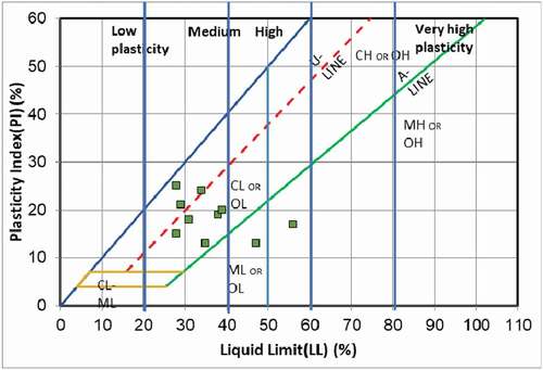
Figure 5. Slope classes and profiles.
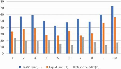
Similar studies obtained the same results. Hungr and Picarelli (Citation2014) indicated that the debris flows are likely to be triggered when materials are close to their liquid limit. Gougazeh and Al-Shabatat (Citation2018) also reported that the alluvium materials are slightly to moderately plastic, while the landslide materials are classified as moderate to high plasticity and they reflected high swell potential due to the presence of considerable amount of expansive clays (smectite).
Classification of soils using XRD
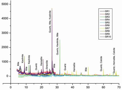
The results of studied samples are expressed as semi-quantitative estimates of the mineral abundances in weight percentages of whole rock analysis. Minerals identified in the study area were clay mineral groups such as kaolinite, illite, and smectite. Clay minerals were identified together with their parent material such as silica, micas, feldspars, and quartz. Other minerals recognized include hematite and goethite. The most dominant mineral identified was quartz; illite minerals were the most dominant amongst clay minerals, while the alluvium materials are mostly composed of quartz, calcite, and smectite (montmorillonite). The results of X-ray diffractometry analysis of clays present in the formations () showed a predominance of quartz, illite, and a small amount of kaolinite and calcite. Dolomite is absent in alluvium materials, whereas it is present as traces in the landslide materials.
Figure 6. X-ray diffractogram of the studied samples.
The soils were mainly reddish-yellow in color, varying in texture (silty clay – clay loam clay – clay loam and clay loam) and medium plasticity. Compared with soils from other parts of the world, they developed on volcanic cones or associated with a landslide. Although physical attributes suggest that soils are not in a critical state, ongoing human activities can improve deep climatic conditions and, ultimately, alter the physical characteristics of current soils to make them critical. Flush formations characterized by a high percentage of clay or marl are deforested and plowed by local farmers. The work of these lands makes them, in addition to their leaching and erosion, less consolidated and more permeable, and therefore vulnerable to landslides.
Discussion
Relation of Landslide susceptibility and geotechnical, mineralogical analysis
Many landslides occurred in the study area as a result of intense rainfall, clayey and marly nature of the outcropping rocks and valleys associated with steep slopes (El Jazouli, Barakat et al., Citation2019b). A general field survey found that about 51 landslides occurred in this area during that time. Based on the results of the general field survey, a zone with a high frequency of landslide susceptibility was selected for a more detailed survey. A detailed field survey was performed for 10 landslides. The soil materials are friable and have a coarse-grained texture of medium size and are characterized by the disturbed location of large blocks of limestone (El Jazouli, Barakat et al., Citation2019a).
As well noted in the landslide susceptibility map integrating eight landslide-related factors produced using AHP (El Jazouli, Barakat et al., Citation2019a), landslides mainly affect the clayey formations locating on steep riverbed slopes. The outcropping formations characterized by the higher percentage of clay or marls are deforested and plowed by local farmers. The carbonate and sandstone rocks, which have high mechanical resistance, presented valueless landslide densities of landslides. However, they are moderately involved in landslides when they form an inclined substratum of the clayey and marly formations which are validated by XRD and Atterberg limits.
The land cover changes, especially vegetation, constitute an important parameter affecting the slope failures (Jazouli, Barakat et al., 2019).
This study illustrated that shear strength parameters decreased with increasing moisture content and that the number of landslides increased relative to the particle size distribution of the clay.
The landslides have occurred mainly within marl-shale units overlain by unconsolidated soil deposits and areas with drainage lines that are affected by erosion and gullying.
Conclusion
There are a wide variety of factors that contribute to the landslide susceptibility. They are generally related to lithology, slope, aspect, elevation, vegetation cover, discontinuity, the location of rivers and roads. While these factors vary from region to region, their effect is, to some degree, known and do not show a great variation apart from geology. One of the greatest flaws in landslide studies applied in the regional scale is that the lithology parameter is determined with a very general approach. In other words, these studies classify the units according to names in geologic terms and relate these units to the landslide susceptibility. However, this is a rather rough approach as these variations in these units have different effects on landslides. The lithological units could not continue the primary properties of discontinuity, elastic, strength, etc. For this reason, the units showed different degrees of weathering. Under the action of water, the mechanical deformation of the clays that form the dominant fraction of the geological formations of the slope is the main cause. The richness of these clays in kaolinite, smectite, and illite with the strong absorbing power of water has increased the mechanical deformation. This is a source of different effects to landslides. Our study can be regarded as a first attempt at linking simple geotechnical characterizations of clay landslides with clay mineralization using XRD and Atterberg limit tests to support XRD soil classification. It opens promising prospects for landslide monitoring and suggests that measurements could be used to assess the conditions of clay material triggering landslides.
Alternatively, these results highlight the potential value of Geotechnical study on landslide susceptibility in the high Oum Er Rbia river basin to gain insight into the clay soils which considers the main cause of the triggering of landslides.
Disclosure Statement
No potential conflict of interest was reported by the authors.
References
- Althuwaynee, O. F., Pradhan, B., & Ahmad, N. (2014). Estimation of rainfall threshold and its use in landslide hazard mapping of Kuala Lumpur metropolitan and surrounding areas. Landslides, 12(5), 861–875. https://doi.org/https://doi.org/10.1007/s10346-014-0512-y
- ANDRIANI, Gioacchino Francesco, DIPRIZIO, Giuseppe, et PELLEGRINI, Vito. (2015). Landslide susceptibility of the La Catola Torrent catchment area (Daunia Apennines, southern Italy): A new complex multi-step approach. In Engineering Geology for Society and Territory-Volume 5 (pp. 387–392). Cham: Springer.
- ANDRIANI, Gioacchino. (2015). Francesco et parise. Mario. on The Applicability Of Geomechanical Models for Carbonate Rock Masses Interested by Karst Processes. Environmental Earth Sciences, 74(12), 7813-7821.
- Avenard. (1965). L’érosion actuelle dans le bassin de Sebou. INRA-Rabat, 114.
- Carrière, S. R., Jongmans, D., Chambon, G., Bièvre, G., Lanson, B., Bertello, L., Berti, M., Jaboyedoff, M., Malet, J.-P., & Chambers, J. E. (2018). Rheological properties of clayey soils originating from flow-like landslides. Landslides, 15(8), 1615–1630. https://doi.org/https://doi.org/10.1007/s10346-018-0972-6
- CASAGRANDE, Joseph B. Comanche baby language. International Journal of American Linguistics, 1948, vol. 14, no 1, p. 11-14.
- COUSSOT, Philippe, LAIGLE, Dominique, & ARATTANO, Massimo, et al. (1998). Direct determination of rheological characteristics of debris flow. Journal Of Hydraulic Engineering, 124(8), 865-868.
- DAOUDI, Lahcen, KNIDIRI, Abdelouahab, EL IDRISSI, Hicham El Boudour, et al. (2015). Role of the texture of fibrous clay minerals in the plasticity behavior of host materials (Plateau du Kik, Western High Atlas, Morocco). Applied Clay Science, 118, 283–289. https://doi.org/https://doi.org/10.1016/j.clay.2015.10.006
- Das, B. M. (2002). Principles of geotechnical engineering (5th Ed) Thompson leanings. California state University.
- Deer, W. A., Howie, R. A., & Zussman, J. (1992). An introduction to The Rock forming minerals (2nd ed.). Pearson, Prentice Hall.
- Diko, M. L., Banyini, S. C., & Monareng, B. F. (2014). Landslide susceptibility on selected slopes in Dzanani, Limpopo Province, South Africa. Jàmbá: Journal of Disaster Risk Studies, 6 (1), 7. Art. #101. https://doi.org/https://doi.org/10.4102/jamba.v6i1.101.
- Ekosse, G. E., Ngole, V., Sendze, Y., & Ayonghe, S. N. (2005). Environmental mineralogy of unconsolidated surface sediments associated with the 2001 landslides on volcanic cones, Mabeta New Layout, Limbe, Cameroon. Global Journal of Environmental Studies, 4(2), 115–122.
- El Jazouli, A., Barakat, A., & Khellouk, R. (2019a). GIS-multicriteria evaluation using AHP for landslide susceptibility mapping in Oum Er Rbia high basin (Morocco). Geoenvironmental Disasters, 6(1), 1. https://doi.org/https://doi.org/10.1186/s40677-019-0119-7
- El Jazouli, A. E., Barakat, A., Khellouk, R., Rais, J., & Baghdadi, M. E. (2019b). Remote sensing and GIS techniques for prediction of land use land cover change effects on soil erosion in the high basin of the Oum Er Rbia River (Morocco). Remote Sensing Applications: Society and Environment, 13, 361–374. https://doi.org/https://doi.org/10.1016/j.rsase.2018.12.004
- Fall, M., & Sarr, M. A. (2007). Geotechnical characterization of expansive soils and their implications in ground movements in Dakar. Bulletin of Engineering Geology and Environment, 66(3), 279–288. http://doi.10.1007/s10064-006-0070-1
- Gougazeh, M., & Al-Shabatat, A. (2018). Geological and geotechnical properties of soil materials at Tannur dam, Wadi Al Hasa, South Jordan. Journal of Taibah University for Science, 7(4), 216–224. https://doi.org/https://doi.org/10.1016/j.jtusci.2013.07.001
- Gourley, C. S., Newill, D., & Schreiner, H. D. (1993, July 5-8).Expansive soil: TRL’s research strategy. In P. G. Fookes & R. H. G. Parry (Eds.), First international symposium on engineering characteristics of arid soils, Volume PA1301/93: CityUniversity, London, (pp. 247–260). Overseas Center, Transport Research Laboratory.
- HORN, G. F. J. et STRYDOM, J. H. Clay. (1998). The mineral resources of South Africa: Handbook. Pretoria: Council for Geoscience, 1998, p. 106-135.
- Hungr, O., & Picarelli, L. S. (2014). Varnes classification of landslide types, an update. Landslides, 11(2), 167–194. https://doi.org/https://doi.org/10.1007/s10346-013-0436-y
- Loubser, M., & Verryn, S. (2008). Combining XRF and XRD analyses and sample preparation to solve mineralogical problems. South African Journal of Geology, 111(2–3), 229–238. https://doi.org/https://doi.org/10.2113/gssajg.111.2–3.229
- MALET, Jean-Philippe, VAN ASCH, Th, & WJ, VAN BEEK, R., et al. Forecasting the behaviour of complex landslides with a spatially distributed hydrological model. 2005.
- Mitchell, J. K. (1993). Fundamentals of Soil Behavior. John Wiley & Son, Inc.
- Nesse, W. D. (2000). Introduction to mineralogy. University Press, Inc.
- Ngole, V. M., Ekosse, G., & Ayonghe, S. N. (2007). Physico-chemical, mineralogical and chemical considerations in understanding the 2001 Mabeta New Layout landslide, Cameroon. Journal of Applied Science and Environmental Management, 11(2), 201–208.
- Sangchini, E. K., Emami, S. N., Tahmasebipour, N., Pourghasemi, H. R., Naghibi, S. A., Arami, S. A., & Pradhan, B. (2016). Assessment and comparison of combined bivariate and AHP models with logistic regression for landslide susceptibility mapping in the Chaharmahal-e-Bakhtiari Province, Iran. Arabian Journal of Geosciences, 9(3), 3. https://doi.org/https://doi.org/10.1007/s12517-015-2258-9
- Thomas, P. J., Baker, J. C., & Zelazy, L. W. (2000). An Expansive soil index for predicting shrink-swell potential. Soil Society of American Journal, 64(1), 268–274. https://doi.org/https://doi.org/10.2136/sssaj2000.641268x
- V. Vakhshoori & M. Zare (2016). Landslide susceptibility mapping by comparing weight of evidence, fuzzy logic, and frequency ratio methods, 7(5), 1731–1752.doi:https://doi.org/10.1080/19475705.2016.1144655
- Wroth, C., & Wood, D. (1978). The correlation of index properties with some basic engineering properties of soils. Canadian Geotechnical Journal, 15(2), 137–145. https://doi.org/https://doi.org/10.1139/t78-014
- Yalcin, A. (2007). The effects of clay on landslides: A case study. Applied Clay Science, 38(1–2), 77–85. https://doi.org/https://doi.org/10.1016/j.clay.2007.01.007
- Yalcin, A. (2011). A geotechnical study on the landslides in the Trabzon Province, NE, Turkey. Applied Clay Science, 52(1–2), 11–19. https://doi.org/https://doi.org/10.1016/j.clay.2011.01.015
- Yalcin, A. J. C. (2008). GIS-based landslide susceptibility mapping using analytical hierarchy process and bivariate statistics in Ardesen (Turkey): Comparisons of results and confirmations. Catena. 72(1), 1–12.