
 ?Mathematical formulae have been encoded as MathML and are displayed in this HTML version using MathJax in order to improve their display. Uncheck the box to turn MathJax off. This feature requires Javascript. Click on a formula to zoom.
ABSTRACT
Increasing land demands for food production has led to large-scale soil degradation in the hilly regions of south-eastern Bangladesh. An intensification of slash-and-burn techniques, where fallow intervals have shortened considerably in recent years, has led to widespread losses in soil quality. Here we sought to test to what extent do current agroforestry practices in the area, compared with current reforestation efforts, can ameliorate different physicochemical soil properties after the abandonment of slash-and-burn practices. We observed that concentrations of soil organic matter (4.75%), available phosphorous (12.17 μg g−1) and exchangeable potassium (0.39 mg kg−1) in agroforestry plots were significantly higher than in reforestation (3.18%, 6.50 μg g−1 and 0.21 mg kg−1, respectively) or slash-and-burn plots (1.83%, 5.90 μg g−1 and 0.03 mg kg−1, respectively). While reforestation and agroforestry may both serve to restore soil functions but we observed higher benefits in the latter system. Thus, agroforestry systems may be a suitable land management system for replacing ancestral slash and burn techniques but care should be taken to diminish soil compaction.
Introduction
One of the main challenges during the 21st century will be to ensure food supply while avoiding large-scale land degradation under global change. In many areas globally, including Bangladesh, land degradation has been increasing at an alarming rate. Ancestral management techniques, such as slash-and-burn, are under pressure to provide support for an increasing population (Biswas et al., Citation2012; Suryatmojo, Citation2014). This has led to the shortening of the fallow period from 15–20 years in the 1900 s to just to 3–5 years nowadays. Such reductions in the rotation period have not been accompanied by adequate measures to enhance soil conservation or to protect against soil erosion, biodiversity loss or overall environmental degradation which restricts sustainable development of the land resources (Duguma, Gockowski & Bakala, Citation2001; Van Noordwijk et al., Citation2008). An unintended consequence of shortening fallow periods is the decline in soil fertility. The Chittagong Hill Tracts (CHTs) from south-eastern Bangladesh are particularly sensitive to soil degradation because the area is characterized by steep slopes, often reaching above 40%, which may increase soil erosion and, consequently, soil fertility losses (Lenka et al., Citation2012). Besides, annual crop production by slash-and-burn practice in steep slopes adversely affected the forest genetic resources and hampered ecosystem functioning (Biswas et al., Citation2012; Haque et al., Citation2014).
Bangladesh is an emergent nation where most of the people live under the poverty line. The challenge to provide food provisioning to an ever-increasing population while maintaining the function of natural ecosystems remains a formidable challenge for the country. The situation particularly critical in the CHTs because indigenous communities depend exclusively on CHT ecosystems as a food source. CHT ecosystems support food for 1.5 million people but the decline in the fallow period under slash-and-burn has led to alarming reductions in the productivity of the CHTs’ ecosystems. Large portions of intact forests are being converted into agricultural lands as a result of such yield declines (K. N. Islam et al., Citation2019). Land use changes and illegal tree logging, along with other forms of forest degradation, are estimated to deteriorate ~2,000 ha of intact forest lands annually in Bangladesh (FAO, Citation2010). It is thus important to develop alternative practices that enhance soil or environmental preservation while ensuring food provisioning.
Agroforestry, the association of trees with farming practices, plays an increasingly recognized role in mitigating the harmful effects of global change and soil degradation (Verchot et al., Citation2007). This land use system has been reported to enhance soil nutrient status, carbon sequestration capacity, improve air and water quality and foster biodiversity conservation (Dollinger & Jose, Citation2018; Jose, Citation2009). Agroforestry systems are especially important to enhance soil quality and fertility because of their capacity to control soil erosion, to maintain optimum soil organic matter and different soil physicochemical properties and subsequently, to ameliorate of soil biodiversity (Dollinger & Jose, Citation2018; Marsden et al., Citation2019). This system may enhance ecosystem functioning while simultaneously improving the goods and services obtained from farms and forest ecosystems (Gold & Garrett, Citation2009). At global scales, agroforestry may also play an important role in mitigating the atmospheric accumulation of greenhouse gases as it increases soil carbon accumulation (IPCC, Citation2000). In principle, agroforestry is preferred over a forest plantation for food provisioning because a larger number of edible species may be introduced in the system. Agroforestry practiced by the smallholder residents in the CHTs could thus be an efficient strategy to reduce poverty and protect natural ecosystems (Nath et al., Citation2005).
Different studies have addressed how soil properties vary across land use systems, and there is a broad consensus now that slash-and-burn practices impoverish soil nutrients in the CHTs (Biswas et al., Citation2012; Haque et al., Citation2014; K. R. Islam & Weil, Citation2000; Mahmud et al., Citation2018). Here we seek to understand the potential of agroforestry as a soil restoration technique because its impact over CHT soil nutrients still has to be quantified. In particular, we seek to quantify to which extent does soil quality increase after replacing slash-and-burn practices by agroforestry and whether it is a more appropriate soil restoration tool than reforestation. More specifically, we tested the predictions that: (i) both agroforestry and reforestation are suitable techniques for soil restoration in degraded slash-and-burn ecosystems of the CHTs, but (ii) agroforestry systems will enhance soil fertility to a larger extent than reforestation. To this end, we sampled soils in CHTs () used for agroforestry, forest plantation and slash-and-burn practices (from now on mentioned as denuded hills). We tested for variations in soil texture and soil physical properties such as soil moisture content (MC), moist bulk density (MBD), dry bulk density (DBD) and particle density (PD). We also quantified differences across land use types on soil chemical properties such as pH, soil organic carbon (SOC), soil organic matter (SOM), total nitrogen (N), available phosphorus (P), and exchangeable potassium (K). Then, we discussed the effects of SOM on different soil properties across different land uses. We used SOM as the main factor to determine the effect on different soil physicochemical properties because SOM influences many soil properties including bulk density, cation exchange capacity, nitrogen availability, and several key soil quality parameters (Patiram, Citation2003). Finally, we conclude our study by highlighting the key findings, suggesting future researches, and also by providing recommendations on best soil conservation practices for the CHTs of Bangladesh.
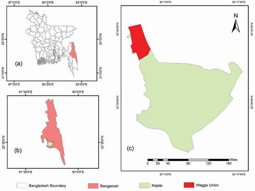
Figure 1. Map of the study area; map of (a) Bangladesh highlighting Rangamati, (b) Rangamati districts highlighting Kaptai and (c) Wagga Union (Red color) in Kaptai Upazila.
Materials and methods
Study area
The study was conducted at Wagga Union (22°31ʹ15.2” N and 92°07ʹ49.1” E), under Kaptai Upazila, in the CHTs of Bangladesh (). CHTs show an undulating relief with hills running from North-South, and with summits reaching 300 − 1,000 m above mean sea level. Slopes are generally above 40%, and they are often subject to landslides and soil erosion. Soils in the study area develop from semi-consolidated to consolidated shales, siltstones, and sandstones. The area has a tropical climate with heavy rainfall concentrated in the summer monsoon period (Feroz et al., Citation2014). The parent materials are low in weatherable minerals (Biswas et al., Citation2012). The area is known for its high-intensity slash-and-burn practiced on the steep slopes of the hills by the indigenous people (Suryatmojo, Citation2014). To protect this hilly area from further degradation, agroforestry and reforestation practices have been established in different parts of the CHTs.
Experimental design
As previously mentioned, we used sampled across three land use categories, agroforestry, forest plantations, and denuded hills. The sampling plots within the agroforestry and reforested land use types used to be under a slash-and-burn regime, and they were transformed into the current land use type about 10 years before experiment inception. The denuded hills ecosystem (slash-and-burn practice) at the time of sampling had been left fallow for 3 years after the last harvest. The slash-and-burn denuded hills were characterized by no vegetation while the plantation forest was dominated by Acacia auriculiformis and a scarce litter cover on the soil. Agroforestry plots had an intensive seasonal mixed cropping practice throughout the year, along with fruit trees such as Mangifera indica (Mango), Psidium spp. (Guava) and Carica spp. (Papaya). Agroforestry plots were treated mechanically during farming and harvesting seasons, and they were fertilized by cow manure.
Four plots within each land use type were selected randomly from each of three different villages (i.e.,: Pagliupor, Paglimoddho, and Paglinichu) within Wagga Union (). We collected samples at 0–15 cm depth in the middle of the slope using a soil auger (four samples per plot) and a soil core (four samples per plot). To avoid the interaction among the different land-use types, sampling points were taken at least 30 m inside the boundary of each land-use category. Hence, 96 soil samples (3 villages 4 plots
4 samples
2 soil sampling tools (auger and core)) were taken per land use type, adding up to 288 samples in total (96
3 land use types). Soil samples collected by auger were used for analyses of soil chemical properties (N, P, K, SOC, SOM and pH) and samples collected by soil core were used for measuring soil physical properties (soil MC, MBD, DBD and particle density). For soil texture measurements, one composite sample was analyzed by mixing the 48 soil samples (3 villages
4 plots
4 samples) within a land use. The soil samples were packed and labelled with airtight plastic bags for further laboratory analyses. In the laboratory, we sieved the samples for chemical analyses through a 10-mm wire mesh to remove gravel, small stones, and coarse roots, and then we passed the sample through a 2-mm sieve. We then stored the sieved samples at room temperature. Moist samples of soil were oven-dried at 105°C for 48 h.
Determination of soil physical properties
Soil texture was determined with the Bouyoucos hydrometer method (Miah et al., Citation2010). To determine soil PD, we used two cylinders marked every 10 mL. The first cylinder was filled with 10 mL of water and the second with 2 g of soil, which had been previously burned in a furnace and weighed (Sw). We poured the water from the first cylinder to the cylinder with burned soil until the water level reached the 10 mL mark and we calculated sample volume (Sv) as the water remaining in the first cylinder. Soil PD was then determined following (Mahmud et al., Citation2018).
We determined the MBD and DBD following (Davidson, Citation1986):
Where, W1 = Weight of core; W2 = Weight of core + field moist soil; W3 = Weight of core + dry soil; V = Volume of core (100 cm3).
Dried soil samples were used to determine moisture content (MC):
where, W3 = Weight of Petri-dish; W4 = Weight of Petri-dish + field moist soil; W5 = Weight of Petri-dish + dry soil.
Determination of soil chemical properties
We determined SOC and SOM with the Loss of Ignition (LoI) method (Ball, Citation1964). LoI was expressed as loss in weight relative to dry soil weight soil. Percentage of LoI was calculated as:
Where W6 = Loss in weight; W7 = weight of oven-dry soil
Percentage of SOC and SOM were calculated as:
On the other hand, soil pH was measured from moist soil by an electronic pH meter in a 1:2.5 soil-water suspension (Jackson, Citation1973). Total N was determined by the micro-Kjeldahl method (Jackson et al., Citation1976) and exchangeable K concentration was quantified using a flame photometer (Jackson, Citation1973). Available P was extracted using ammonium fluoride-hydrochloric acid (Bray and Kurtz-2) followed by SnCl2 reduced molybdophosphoric blue color method (Jackson, Citation1973).
Statistical analyses
We examined statistical differences across land use types using a Duncan’s Multiple Range Test (DMRT), a post-hoc analysis. Statistical analyses were performed with SPSS 20.0 (version 20.00; SPSS Inc., Chicago, IL, USA) and after testing for homogeneity of variance and normal distribution.
Results
Soil physical properties
Soil texture varied between being sandy loam in forest plantations and denuded hills and sandy clay loam in agroforestry plots. That is, there were less fine sand and clay particles in agroforestry plots, compared to denuded slash-and-burn hills and plantation sites (). In case of soil physical properties, DBD and MBD were significantly higher in agroforestry plots (1.35 g cm−3 and 1.42 g cm−3, respectively), than in denuded slash-and-burn hills (1.20 g cm−3 and 1.24 g cm−3, respectively) or than in adjacent forest plantations (1.08 g cm−3 and 1.17 g cm−3, respectively), whereas there was no significant difference in DBD or MBD between the forest plantation and the denuded hills ().
Table 1. Soil texture across land-use types
Table 2. Soil physical properties across land-use types
We observed no significant differences in soil MC between the agroforestry plots (5.62%) and the denuded hills (3.64%), but soil MC was significantly higher in forest plantations (8.43%) (). There were no significant differences in PD across land-use types, which was 1.40 g cm−3 in forest plantations and denuded hills and 1.36 g cm−3 in agroforestry plots ().
Soil chemical properties
We observed that SOM was significantly higher in the agroforestry plots (4.75%) than in adjacent forest plantations (3.18%) and denuded hills (1.83%) (). Soils were always acidic, with a pH significantly higher in denuded slash-and-burn hills (5.94) than in forest plantations (5.22) and agroforestry plots (4.85) ().
Table 3. Soil chemical properties across land-use types
Total N was significantly higher in the forest plantations (0.15%) than in the denuded slash-and-burn hills (0.10%) or the agroforestry plots (0.08%) (). However, available P was significantly higher in agroforestry plots (12.17 μg g−1), relative to the other two land use types. There were no significant differences in P concentration between the forest plantation (6.50 μg g−1) and the denuded slash-and-burn hills (5.90 μg g−1) (). Exchangeable K was highest in agroforestry plots (0.39 mg kg−1), followed by the forest plantations (0.21 mg kg−1) and the denuded slash-and-burn hills (0.03 mg kg−1) ().
Discussion
In general, the study showed that soil in agroforestry and forest plantation sites were more fertile than the soils in denuded hills although agroforestry plots generally showed a higher degree of nutrient improvement than plantations. A negative aspect of agroforestry plots was the higher bulk density, which likely results from higher soil compaction after the introduction of heavy machinery for farming activities. Similar findings have been reported in studies performed in teak plantations from the Kaptai area (Mahmud et al., Citation2018). The soil under teak plantations was also prone to soil compaction because of forest management practices and mechanical use during harvesting. Generally, low bulk density facilitates SOM intake in the soil. However, SOM was highest in our agroforestry plots (; )). SOM in agroforestry systems can be maintained at higher levels due to the contribution of decomposed residues (Sharma et al., Citation2009). This contribution may come from above-ground litter, pruning or root residues as well as different fertilization practices. Such accumulation of organic components led to an enriched amount of organic matter, which lowered the level of pH in agroforestry plots ( and )).
Figure 2. Relation between SOM with (a) pH, (b) DBD, (c) P, (d) K and (e) N in the three different land-use systems. Error bar indicates the standard error of the mean.
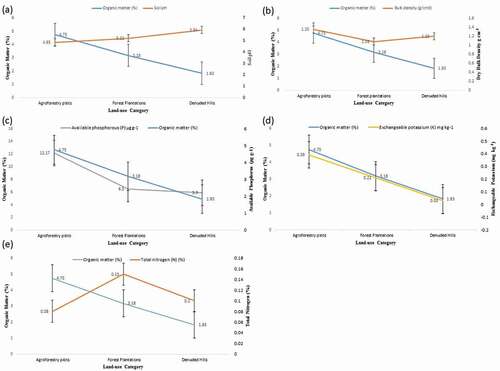
Forest plantations, showed intermediate soil fertility and pH levels because of the intermediate nutrient inputs while the denuded hills showed the lowest fertility values, likely as a result of the long-term degradation. Earlier reports in this area also found a significant increase in pH in slash-and-burn cultivated soils because of the introduction of base-rich ashes during the burn (Lessa et al., Citation1996).
We observed that P and K followed the same pattern as SOM across different land-use types (; ). That is, P and K were highest in agroforestry plots, intermediate in the forest plantation, and lowest at the denuded hills. This is likely because higher SOM in humus enhances soil nutrient retention and, as humus declines, nutrients tend to leach out from the soil during water or wind runoff. The increase in P and K during agroforestry practices could additionally result from fertilization with organic compost. There was study which found an increase in available P and K in agroforestry plots because of long-term fertilization from cow dung (Singh et al., Citation2003). Naturally, these nutrient contents depend on the decomposition of organic matter. That is, higher decomposition of organic matters in the soil leads to higher concentrations of P and K in the soil, as we observed in our agroforestry plots, similar to other studies (Haque et al., Citation2014; Mahmud et al., Citation2018).
An unexpected result was that total N declined in the agroforestry plots, although they showed the highest SOM, relative to plantation sites and denuded hills ( and )). The higher concentration of total N in forest soils has also been previously observed (Zaman et al., Citation2010) and it is likely the result of nitrogen fixation by the nodules of A. auriculiformis trees, a legume, in the plantation forest. Although agroforestry increased soil fertility and SOM, it also increased bulk density, likely as a result of soil compaction. Soil compaction is associated with activities like felling and clearing of the vegetation which, in turn, might reduce soil fertility. For instance, one of the negative consequences of soil compaction might be the lower total N concentration that we observed in agroforestry plots.
Our results of soil MC were inherently limited by the temporal sampling since we only sampled once in the dry season during February – March. We can speculate that plantation forest floors conserve soil MC because increases in plant cover reduce water losses from soil evaporation, but we would need additional sampling at more dates for confirming this pattern. Nonetheless, other studies have also observed that forested soils contain higher soil MC than deforested areas (Haque et al., Citation2014).
Conclusion
This study was conducted to measure different soil physicochemical properties of agroforestry plots, forest plantations, and denuded hills in order to elucidate the impacts of agroforestry and forest plantations on the soil of slash-and-burn denuded hills. Results were supported our hypotheses that soils in agroforestry plots and forest plantations contained higher concentrations of nutrients compared to denuded hills, and agroforestry provided higher advantages over soil fertility than forest plantations. However, care should be taken to diminish soil compaction at agroforestry sites, as in our study negative effects over soil N were already apparent in this land use type. Further research could address whether a reduction in the use of heavy machinery for farming practices in agroforestry would minimize the long-term soil compaction problems. Additionally, N inputs could also be increased by planting seasonal leguminous crops in the agroforestry plots. Future research might focuses on finding suitable leguminous crops to increase total N concentration in the agroforestry systems without negatively affecting food production.
Our results indicate that the agroforestry system may potentially improve soil fertility to a greater extent than forest plantations in areas previously subjected to slash-and-burn practices. Our results indicate that agroforestry systems is a promising approach towards sustainable land management in the CHTs and other tropical hilly regions. Awareness campaigns from Governments and local NGOs, along with financial incentives, could be an effective method to encourage the widespread application of agroforestry practices that replace the traditional slash-and-burn cultivation system.
Acknowledgments
Authors like to thanks the Institute of Forestry and Environmental Sciences (IFES) of Chittagong University, Bangladesh for providing the opportunity to use the lab facilities. The authors also would like to thank two anonymous reviewers for their constructive comments and suggestions in an earlier version of the manuscript.
Disclosure statement
No potential conflict of interest was reported by the authors.
Additional information
Funding
References
- Ball, D. F. (1964). Loss-on-ignition as an estimate of organic matter and carbon in non-calcareous soils. Journal of Soil Science, 15(1), 84–92. https://doi.org/https://doi.org/10.1111/j.1365-2389.1964.tb00247.x
- Biswas, A., Alamgir, M., Haque, S. M. S., & Osman, K. T. (2012). Study on soils under shifting cultivation and other land use categories in Chittagong Hill tracts, Bangladesh. Journal of Forestry Research, 23(2), 261–265. https://doi.org/https://doi.org/10.1007/s11676-011-0216-2
- Davidson, D. A. (1986). Soil physical measurement and interpretation for land evaluation. Aclep, Land Evaluation Program, 2, 1–16. https://doi.org/https://doi.org/10.4135/9781446216187.n164
- Dollinger, J., & Jose, S. (2018). Agroforestry for soil health. Agroforestry Systems, 92(2), 213–219. https://doi.org/https://doi.org/10.1007/s10457-018-0223-9
- Duguma, B., Gockowski, J., & Bakala, J. (2001). Smallholder cacao (Theobroma cacao Linn.) cultivation in agroforestry systems of West and Central africa: Challenges and opportunities. Agroforestry Systems, 51(3), 177–188. https://doi.org/https://doi.org/10.1023/A:1010747224249
- FAO. (2010). Global forest resources assessment 2010. FAO Forestry Paper, 163, 230-231.http://www.fao.org/3/a-i1757e.pdf
- Feroz, S. M., Alam, M. R., Das, P., & Al Mamun, A. (2014). Community ecology and spatial distribution of trees in a tropical wet evergreen forest in Kaptai national park in Chittagong Hill Tracts, Bangladesh. Journal of Forestry Research, 25(2), 311–318. https://doi.org/https://doi.org/10.1007/s11676-013-0423-0
- Gold, M. A., & Garrett, H. E. (2009). Agroforestry nomenclature, concepts, and practices, chapter 3: 45-46. In H. E. Garrett (Ed.), North American agroforestry: An integrated science and practice (2nd ed.). Agronomy Society of America.https://doi.org/https://doi.org/10.2134/2009.northamericanagroforestry.2ed.c3
- Haque, S. M. S., Gupta, S. D., & Miah, S. (2014). Deforestation effects on biological and other important soil properties in an upland watershed of Bangladesh. Journal of Forestry Research, 25(4), 877–885. https://doi.org/https://doi.org/10.1007/s11676-014-0534-2
- IPCC. (2000). Land-use, land-use change and forestry. Special report of the intergovernmental panel on climate change. Cambridge University press. Retrieved November 28, 2019, from https://archive.ipcc.ch/ipccreports/sres/land_use/index.php?idp=0
- Islam, K. N., Rahman, M. M., Jashimuddin, M., Hossain, M. M., Islam, K., & Faroque, M. A. (2019). Analyzing multi-temporal satellite imagery and stakeholders’ perceptions to have an insight into how forest co-management is changing the protected area landscapes in Bangladesh. Forest Policy and Economics, 101(November2018), 70–80. https://doi.org/https://doi.org/10.1016/j.forpol.2019.01.011
- Islam, K. R., & Weil, R. R. (2000). Land use effects on soil quality in a tropical forest ecosystem of Bangladesh. Agriculture, Ecosystems and Environment, 79(1), 9–16. https://doi.org/https://doi.org/10.1016/S0167-8809(99)00145-0
- Jackson, M. L. (1973). Soil chemical analysis. Prantice Hall of India Pvt. Ltd.
- Jackson, W. A., Kwik, K. D., & Volk, R. J. (1976). Nitrate uptake during recovery from nitrogen deficiency. Physiologia Plantarum, 36(2), 174–181. https://doi.org/https://doi.org/10.1111/j.1399-3054.1976.tb03931.x
- Jose, S. (2009). Agroforestry for ecosystem services and environmental benefits: An overview. Agroforestry Systems, 76(1), 1–10. https://doi.org/https://doi.org/10.1007/s10457-009-9229-7
- Lenka, N. K., Choudhury, P. R., Sudhishri, S., Dass, A., & Patnaik, U. S. (2012). Soil aggregation, carbon build up and root zone soil moisture in degraded sloping lands under selected agroforestry based rehabilitation systems in eastern India. Agriculture, Ecosystems and Environment, 150, 54–62. https://doi.org/https://doi.org/10.1016/j.agee.2012.01.003
- Lessa, S. N. A., Andersen, D. W., & Moir, J. O. (1996). Fine root mineralization, soil organic matter and exchangeable cation dynamics in slash-and-burn agriculture in the semi-arid northeast Brazil. Agriculture, Ecosystems and Environment, 59(3), 191–202. https://doi.org/https://doi.org/10.1016/0167-8809(96)01044-4
- Mahmud, A. A., Mahfuzur, R., & Hossain, M. K. (2018). The effects of teak monoculture on forest soils: A case study in Bangladesh. Journal of Forestry Research, 29(4), 1111–1120. https://doi.org/https://doi.org/10.1007/s11676-017-0515-3
- Marsden, C., Martin-Chave, A., Cortet, J., Hedde, M., & Capowiez, Y. (2019). How agroforestry systems influence soil fauna and their functions - A review. Plant and Soil. https://doi.org/https://doi.org/10.1007/s11104-019-04322-4
- Miah, S., Dey, S., & Sirajul Haque, S. M. (2010). Shifting cultivation effects on soil fungi and bacterial population in Chittagong Hill Tracts, Bangladesh. Journal of Forestry Research, 21(3), 311–318. https://doi.org/https://doi.org/10.1007/s11676-010-0076-1
- Nath, T. K., Inoue, M., & Myant, H. (2005). Small-scale agroforestry for upland community development: A case study from Chittagong Hill Tracts, Bangladesh. Journal of Forest Research, 10(6), 443–452. https://doi.org/https://doi.org/10.1007/s10310-005-0171-x
- Patiram. (2003). Soil health for sustainable production. In B. P. Bhatt, K. M. Bujabaruah, Y. P. Sharma, & Patiram (Eds.), Approches for increasing agricultural production in hills and mountain ecosysytem (pp. 15–25). ICAR Research Complex for NEH Region.
- Sharma, K. L., Ramachandra Raju, K., Das, S. K., Prasad Rao, B. R. C., Kulkarni, B. S., Srinivas, K., Grace, J. K., Madhavi, M., & Gajbhiye, P. N. (2009). Soil fertility and quality assessment under tree-, crop-, and pasture-based land-use systems in a rainfed environment. Communications in Soil Science and Plant Analysis, 40(9–10), 1436–1461. https://doi.org/https://doi.org/10.1080/00103620902818096
- Singh, J., Bora, I. P., & Baruah, A. (2003). Effect of shifting cultivation on nutrient status of soil in Silonijan (Karbi-Anglong) Assam. Indian Journal of Forestry, 26(2), 116–122.http://www.indianforester.co.in/index.php/indianforester/article/view/2413
- Suryatmojo, H. (2014). Recovery of forest soil disturbance in the intensive forest management system. Procedia Environmental Sciences, 20, 832–840. https://doi.org/https://doi.org/10.1016/j.proenv.2014.03.101
- Van Noordwijk, M., Mulyoutami, E., Sakuntaladewi, N., & Agus, F. (2008). Swiddens in transition: Shifted perceptions on shifting cultivators in Indonesia. ICRAF Occasional Paper.
- Verchot, L. V., Van Noordwijk, M., Kandji, S., Tomich, T., Ong, C., Albrecht, A., Mackensen, J., Bantilan, C., Anupama, K. V., & Palm, C. (2007). Climate change: Linking adaptation and mitigation through agroforestry. Mitigation and Adaptation Strategies for Global Change, 12(5), 901–918. https://doi.org/https://doi.org/10.1007/s11027-007-9105-6
- Zaman, M. A., Osman, K. T., & Sirajul Haque, S. M. (2010). Comparative study of some soil properties in forested and deforested areas in Cox’s Bazar and Rangamati Districts, Bangladesh. Journal of Forestry Research, 21(3), 319–322. https://doi.org/https://doi.org/10.1007/s11676-010-0077-0