
 ?Mathematical formulae have been encoded as MathML and are displayed in this HTML version using MathJax in order to improve their display. Uncheck the box to turn MathJax off. This feature requires Javascript. Click on a formula to zoom.
ABSTRACT
Soil erosion is one of the major environmental issues in Ethiopia. In highlands, though the topography is rugged; settlements have increased in recent years even if cultivation is generally practiced on steep landforms. Deforestation and anthropogenic activities have resulted in excessive soil erosion. In this study, a webGIS-based decision support system (DSS) was developed to provide complete information on soil erosion. The parameters employed were estimated using remote sensing data. Prioritization of micro-watersheds was done on the basis of soil erosion risk through GIS. Very high soil loss of 69.9 t. ha−1.yr−1 to 138.4 t. ha−1.yr−1 was noticed in four micro-watersheds while the same was medium (59.9−69.9 t. ha−1.yr−1 in another micro-watershed. About 69.8% of the total micro-watershed area showed a soil loss of 0.53−18 t. ha−1.yr−1 though average soil loss in each land parcel was 25.82 t. ha−1.yr−1. Thus, this webGIS helps non-technical users to access information and understand soil conservation program to find soil erosion reduction measures in the study area. Moreover, the information also assists various natural resource-based applications to identification the jeopardized areas so that required conservation measures could be initiated.
Introduction
Soil erosion is a natural process that causes loss of topsoil and reduction in fertility of agricultural land in mountainous terrain (Qin et al., Citation2018; Sharma, Citation2010; Thapa, Citation2020). Soil erosion results from several parameters such as rainfall, runoff, soil characteristics, terrain features, topsoil thickness, plantation, and land-cover (Fayas et al., Citation2019; Gete, Citation2000). Soil erosion is a severe environmental problem, particularly when high-intensity rainfall is recorded and poor land management is practiced (Belayneh et al., Citation2019; Gebreyesus & Kirubel, Citation2009; Suryabhagavan, Citation2017; Trenberth, Citation2011). Degradation of agricultural land by soil erosion is a worldwide phenomenon leading to loss of nutrient-rich surface soil, increased runoff from the impermeable subsoil, and decreased water availability for crops (Ganasri & Ramesh, Citation2016). Every year, 25 − 40 billion tons of surface soils are removed worldwide due to soil erosion, causing approximately 400 billion dollars worth of direct economic losses through declined crop production (FAOUN, Citation2015; Montanarella, Citation2015; Opeyemi et al., Citation2019; Paulos, Citation2001; Pimental, et al., Citation1995).
The heavy reliance of Ethiopia’s growing population on subsistence agriculture can be considered as one of the primary reasons for the current state of land degradation (Ayele et al., Citation2014; Belayneh et al., Citation2019; Haregeweyn et al., Citation2017). In general, soil erosion has been reported throughout the country however, northern and central Ethiopian highlands are more severely affected by soil erosion. The main reasons reported for excessive soil erosion in the north and central Ethiopian highlands are related to the rugged topography, increased population settlements in recent years, cultivation practice on the steep landforms, deforestation, and other anthropogenic activities (Kebede et al., Citation2021; Moges & Bhat, Citation2017; Yesuph & Dagnew, Citation2019). In general, the land is fragile and susceptible to soil erosion. Besides, mismanagement of land and inadequate soil conservation measures have also resulted in excessive soil erosion in the region (Atoma et al., Citation2020; Nyssen et al., Citation2004; Tadesse et al., Citation2017). Thus, soil erosion has become the most severe problem of Ethiopia’s land resources, particularly in northern and central Ethiopian highlands. In recent years, local administrations are geared up and have put serious attention towards soil conservation and management in the region. In this regard, several research projects are funded to conserve water resources and soil retention and management.
Soil erosion is defined as the physical degradation of the landscape over time. The process is initiated when soil particles are detached from their original configuration by erosive forces such as rainfall and wind. The soil particles may then be transported by overland flow into nearby rivers and oceans (Khosrowpanah et al., Citation2007). Important terrain characteristics influencing the mechanism of soil loss are slope length, shape, and aspect. The impact of slope and aspect would play a significant role in the runoff mechanism. Most studies have indicated that sheet and rill erosion by water and burning of dung and crop residue are the major components of land degradation that affect on-site land productivity (Woldamlak & Teferi, Citation2009). Soil erosion is a naturally occurring process; however, it is accelerated by human activities such as; intensive agriculture, improper land management, deforestation, and cultivation on steep slopes (Foley, Citation2017; Jayasekara et al., Citation2018).
In the past, many scientific works have used satellite data and GIS models to characterize soil erosion (Grimm et al., Citation2003; Haile & Fetene, Citation2012; Kinnell, Citation2010; Lazzari et al., Citation2015). Different empirical and mechanistic models were established to predict soil loss (Atoma et al., Citation2020; Fullen, Citation2003; Lal, Citation2001; Millward & Mersey, Citation1999; Ostovari et al., Citation2021; Tadesse et al., Citation2017). These models provide information about eroding areas, soil types, lithological units, land-use and land-cover, with reduced costs and significant accuracy. Soil erosion models that have been developed to quantify soil erosion are; Universal Soil Loss Equation (USLE), Revised Universal Soil Loss Equation (RUSLE), Modified Universal Soil Loss Equation (MUSLE), Morgan, Morgan and Finney Model (MMF), European Soil Erosion Model (EUROSEM), Griffith University Erosion System Template (GUEST), Limburg Soil Erosion Model (LISEM), Water Erosion Prediction Project (WEPP), Unit Stream Power-based Erosion Model (USPED) and Soil and Water Assessment Tool (SWAT) (Arnold et al., Citation1998; Jha & Paudel, Citation2010; Laflen et al., Citation1985; Maurya et al., Citation2021; Nasiri, Citation2013; Renard et al., Citation1997; De Roo et al., Citation1996; Rose et al., Citation2003; Van der Knijff et al., Citation2000; Wischmeier & Smith, Citation1978). Soil erosion predictions at the watershed and regional scales are usually regarded as the scientific basis for land management and decision-making. The model computations are made in a raster-based GIS, and the model provides information on potential soil loss on a cell-by-cell basis (Singh, Citation2019). However, validation of such spatial soil loss predictions is generally difficult (Gobin et al., Citation2004). Very few studies in the literature have reported validation of soil erosion maps (Prasuhn et al., Citation2013).
In order to support the next generation of multi-process and service-oriented computations, a web-GIS platform is considered a viable solution for gathering and sharing collected data from the watershed so that the information flow is easily managed and interpreted using spatial thematic maps related to specific levels of soil erosion information. Current advances in computational speed, storage, WWW, and software provide an excellent opportunity to develop the Decision Support Systems (DSS) tool to assist decision-makers for program integration (Byong-Lyol et al., Citation1998; Shim et al., Citation2002). Thus, all factor maps and models are an integral part of the decision-making process. The Internet is another factor to be considered when developing a DSS (Yang et al., Citation2005). Advances in communication networks have overcome many difficulties in using timely and spatially distributed resources in the decision-making processes. Therefore, one of the tremendous benefits of using information technologies in decision making is the potential to overcome limited resources in terms of time, data, and communication (Carver, Citation2001; Pandey et al., Citation2000).
The majority of studies on soil erosion focus either on climate or land-use changes, but little work has been done to combine both factors. Globally, the Revised Universal Soil Loss Equation (RUSLE) is the most commonly used empirical model for predicting average annual soil loss (Alexandridis et al., Citation2015; Moges & Bhat, Citation2017; Molla & Sisheber, Citation2017; Yesuph & Dagnew, Citation2019). Even though the model was designed for use at runoff plot or single hillslope scale, the combined use of GIS and RUSLE was used to estimate the magnitude and spatial distribution of erosion in ungagged catchments (Angima et al., Citation2003; Erdogan et al., Citation2007; Fu et al., Citation2005; Raclot et al., Citation2009). The present study was carried out to assess the soil erosion rate and develop a soil erosion intensity map for the Legedadi watershed using the RUSLE model. Importantly, in the current study, all factor maps for the study area were developed as a user-friendly interface with easy access to users for predicting soil erosion. The online tool can be accessed by all users, including farmers and crop consultants, to help develop better management strategies.
Materials and methods
Study area
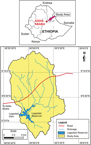
The study area is located about 30 km east of Addis Ababa. One of the sources of drinking water for Addis Ababa and its surroundings is the Legedadi reservoir, which was constructed in 1967 and is located in the upper northwestern part of the Awash basin. The reservoir catchment area falls into Oromia Regional State under the Administration of North Shoa Zone in Aleltu Bereh District. The catchment is bounded by latitude 9°3ʹ0’’−9o13ʹ30’’N and longitude 38°60ʹ30ʹ’−39°02ʹ30ʹ’ E, covering a total area of 234 km2 (). The elevation ranges from 2460 − 3200 m asl in the watershed. The study area receives an annual average rainfall of 1189.8 mm for the past 32 years and exhibits wet climatic conditions with a mean minimum and maximum temperature of 22.95°C and 27.8°C, respectively. The major portion of the watershed is covered by cultivated land, followed by grassland, settlement, forest, and a small fraction of the area is a water body. Geologically, the area falls in the Miocene-Pliocene and Middle Miocene periods. The major rocks present in the study area are conglomerate sandstone, siltstone with basalt, and Sub alkaline Basalt with Rhyolite and Trachyte. Since the catchment basin has different geological formations, it influences the river’s base flow and the run-off coefficient of the basins (Endalkachew, Citation2012). Further, the soil texture is calcic xerosols followed by leptosols, orthic solonchaks, and pellic vertisols.
Figure 1. The location map of the study area.
Methods
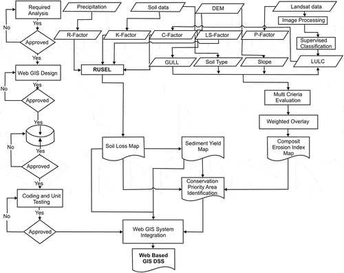
The study was conducted using Remote sensing data, topographic maps (Ethiopian Mapping Agency, on a scale of 1:50,000), secondary data obtained from various Government organizations, and primary data collected from the field observations. Landsat 8 satellite data (the year 2015; path 168 and row 054) were used to generate land-use and land-cover map, and the Digital Elevation Model (DEM) of the area was used, with a spatial resolution of 30 m. Further, the study area’s rainfall data for the years 1984 − 2014 was obtained for six metrological stations located in and around the watershed boundary from the National Meteorological Agency (NMA) of Ethiopia. The soil properties were described based on the soil database compiled by the Food and Agricultural Organization, collected from the Ministry of Agriculture, Federal Government of Ethiopia. Also, the soil types were classified to obtain the K factor values. These K factor values were adopted based on the FAO Soil Classification System (Hurni, Citation1985a). In the first phase of the soil erosion analysis, the criteria for all the considered factors were defined. This was required to assess the soil erosion rate and to develop a soil erosion intensity maThe second phase of this study was to create a user-friendly web-GIS interface with easy access for predicting soil erosion. The detailed flow chart of the methodology is presented in ().
Figure 2. Flow chart of the methodology.
The revised universal soil loss equation (RUSLE)
The RUSLE is an empirical model widely applied in estimating soil erosion in Ethiopia (Abate, Citation2011; Amare et al., Citation2014; Amdihun et al., Citation2014; Kiflu, Citation2010; Woldamlak & Teferi, Citation2009). Soil erosion is directly affected by the climate (rainfall), runoff erosivity, pedological characteristic (soil erodibility), topography (slope length and steepness), land-use and land-cover pattern, and anthropogenic (soil management, erosion control practice) characteristics. RUSLE provides improved means of computing soil erosion factors (Kaltenrieder, Citation2007; Woldamlak & Teferi, Citation2009) (EquationEquation (1)(1)
(1) ):
where A is the computed average soil loss per unit area (t ha−1 yr−1); R is rainfall-runoff erosivity factor (MJ mm h−1 ha−1 y−1); K is soil erodibility factor (t ha−1MJ−1mm−1); L is slope length factor, S is slope steepness factor, C is cover-management practice factor and P is conservation practice factor.
To identify the spatial pattern of potential soil erosion in the study area, all the six erosion factors, presented in EquationEquation (1)(1)
(1) were estimated within a raster grid (Kouli et al., Citation2009).
Rainfall and runoff erosivity factor (R)
Rainfall erosivity represents the capacity of rain to erode the soil (Wischmeier, Citation1959). Soil loss is closely related to rainfall partly through the detaching power of raindrops striking the soil surface and partly through the contribution of rain through runoff (Morgan, Citation1995). In this study, Hurni’s empirical equation (Hurni, Citation1985a) that estimates R-value for Ethiopian highlands from annual total rainfall was used (EquationEquation (2)(2)
(2) ):
where, R is the rainfall erosivity factor and P is the mean annual rainfall in mm. The unit of R is MJ mm t ha−1 yr−1 (Jiang, Citation2013).
Similar methods of determining R values from annual total rainfall have been used in the previous studies (Kiflu, Citation2010; Morgan, Citation2005; Woldamlak & Teferi, Citation2009).
Soil erodibility factor (K)
The soil erodibility, the soil loss rate per R factor unit, can be computed according to the relation proposed by Wischmeier and Smith (Citation1978). The higher the erodibility value the soil has, the more erosion it will suffer when exposed to the same intensity of rainfall, splash, or surface flow (Hudson, Citation1981). The unit for soil erodibility is t ha−1MJ−1mm−1 (Jiang, Citation2013). The K-factor for the soils of the study area was taken as per the study conducted by Helden (Citation1987) (). Further, the K factor raster map was generated for different soil types.
Table 1. Soil erodibility values for soil types (Helden, Citation1987).
Slope length and steepness factor (LS)
For the present study, the Digital Elevation Model was used for the calculation of the LS factor. The original equations proposed by Wischmeier and Smith (Citation1978) have been replaced by the upslope contributing areas (Desmet & Govers, Citation1996; Mitasova et al., Citation1996, Citation1995). LS factor was determined by using the following EquationEquation (3)(3)
(3) :
where, X is the slope length (m) and S is the slope gradient (% or degree).
The values of X and S were derived from DEM. To calculate the X value, Flow accumulation was derived from the DEM after conducting fill and flow in ArcGIS. The values were varied from 0.2 − 0.5 depending on the slope and slope gradient values. For this, a value of 0.5 was taken for slopes exceeding 4.5%, 0.4 for 3 − 5% slopes, 0.3 for 1 − 3%, and 0.2 for slopes less than 1% (Wischmeier & Smith, Citation1978). The LS factor map was prepared from DEM, which corresponded to inter-row matrix cells with the same value.
Cover-management practice factor (C)
The estimation of cover-management or land-use and land-cover was classified by supervised digital image classification technique. Later it was supplemented through ground truth data with the help of GPS field points. The land-use patterns were derived from the interpretation of Landsat 8 image dating 2015. The classified land-use classes were verified by ground truth pixels. To perform quantitative classification accuracy assessment, it is necessary to compare two sources of information: first, the remote sensing derived classification data, and second, the reference test information data obtained from the field observations. The relationship between these two sets of information is summarized in the cell array. The cell array lists class values for the pixels in the classified image and the corresponding reference image (Leica Geosystems, Citation2003). The reference’s class values are based on ground truth data, and the cell array data is retrieved from the image file.
Support practice factor (P)
The support practice factor (P) is the ratio of soil loss with a specific practice to the corresponding loss with upslope and downslope tillage (Renard et al., Citation1997). The conservation practice factor values depend on the type of conservation measures implemented, and it requires the mapping of conserved areas to be quantified. Since permanent management is not practiced in the present study area and no P factor values were available, the values suggested by Wischmeier and Smith (Citation1978) were adopted. Wischmeier and Smith (Citation1978) have considered two types of land-use classes: agricultural land, and other land classes. Thus, for the present study, the P factor value for two land-use and land-cover classes were defined to different slope classes. The agricultural lands were classified into six slope categories, and P factor values were assigned for each type while all non-agricultural lands were assigned a P factor value of 1.00.
Layout of the Web-GIS monitoring platform
The second phase of the present study was to prepare a layout of the monitoring platform. The monitoring platform’s general structure comprises monitoring devices, data acquisition, and factors related to soil erosion. represents the layout of the Web-GIS monitoring platform. The Cloud Server incorporates the database for storing the monitoring data of each factor theme related to soil erosion. The spatial database includes geographical data related to various thematic layers of the factors pertaining to soil erosion. The Geo Server is used to display geographical data. The application server communicates the data to the end-user from the Front End of the soil erosion maps monitoring platform.
Figure 3. Overall layout of the Web-GIS monitoring platform.
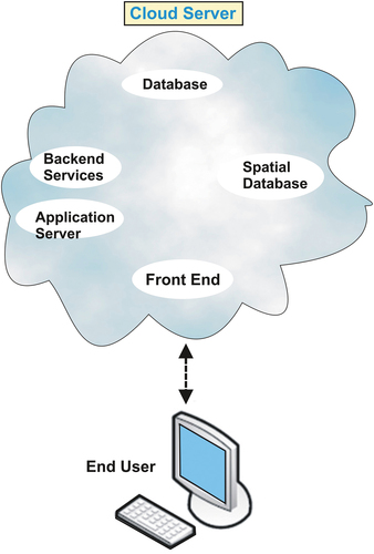
Description of the Cloud Server
The Cloud Server is the heart of the Web-GIS monitoring platform and supports data management and the security and visualization of the maps in the system. The Cloud Server operating system is the distribution of Linux (Carver, Citation2001; McCarty, Citation1999) due to the following characteristics; it is open-source, supports the latest release of various open-source programs and libraries, it inherits security features. The following geospatial data servers were examined and tested for the monitoring platform’s needs; GeoServer, MapGuide Open Source, Mapnik, and MapServer. Finally, the GeoServer was selected as it served most of the requirements of the monitoring platform.
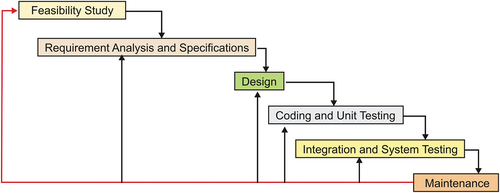
Web-GIS development cycle
Developing a web GIS is more than only using the appropriate hardware and software (Alesheikh et al., Citation2002; Yang et al., Citation2005). GIS-based project development consists of components such as; data development, data organization, and application development that are not similar and different from the standard software development processes. The web-GIS development cycle is a step-by-step method from requirement analysis to the ongoing use and implementation of the expected portal, the iterative RUSLE model ().
Figure 4. Iterative model development and its life cycle.
To develop the system, the most crucial aspect is defining the user’s requirements correctly. Data acquisitions and related activities are to be implemented based on user requirements. Therefore, data is significant in the fulfillment of the condition and the development of the Web-GIS. Once the needs are identified, the next step is to design the system. Like most internet applications, Web-GIS is based on the server/client model. In a server/client system, a computer acts as a client that sends requests to the server computer. The server computer processes the requests and sends the results back to the client () (Ozdilek & Seker, Citation2004). The basic architecture of the system is shown in . There are many possible ways to construct a web-based map system; the main challenge is selecting the appropriate technology (Alesheikh et al., Citation2002). Since the system must be compatible with the open-source environment, the available options are limited.
Figure 5. General system architecture-Client computer and Server computer.
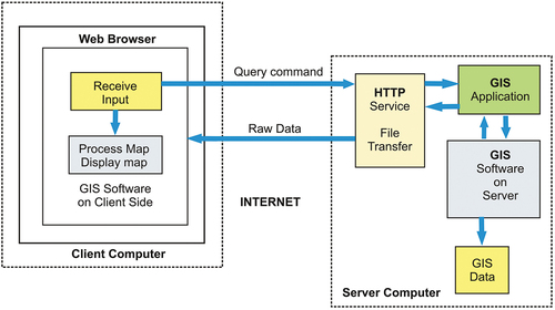
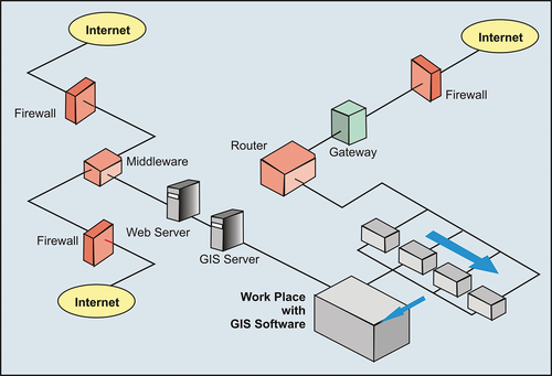
Figure 6. Web-GIS Architecture and process line diagram.
Results
Based on the RUSLE criteria, the required factors were generated for the present study area. The factors that were used to compute the average soil loss are; rainfall-runoff erosivity (R), soil erodibility (K), slope length (L), slope steepness (S), cover-management practice (C), and conservation practice factor (P). This included assigning weight to each factor based on its relative influence on soil erosion. Later, based on these criteria, soil erosion was estimated for the entire study area. Further, based on the amount of soil loss and the area coverage, the entire study area was classified into nine classes. Besides, a webGIS-based platform for the user’s decision support system was also developed. Through the website, this model facilitates exploring soil erosion-prone areas in the watershed under the present study. The developed webGIS-based platform is based on open software tools, flexible, user-friendly, and cost-effective for communities and decision-makers.
Rainfall and runoff erosivity (R) factor
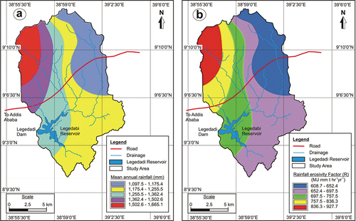
For the present study area, mean annual rainfall data for 1984to 2014 was procured for five meteorological stations from the Ethiopian National Meteorological Services Agency. This data was further analyzed and interpolated to generate the continuous rainfall data for each grid cell within the area under study. Average annual rainfall and runoff erosivity were computed for the study area for the period 1984 to 2014. The mean annual rainfall of the study area ranges from 1097.5−1665.1 mm, as shown in ()). Further, results were interpolated and converted to the continuous surface by using the inverse distance weight method (IDW). Details of meteorological stations used to compute R factors are presented in (). The rainfall erosivity estimated from the mean annual total rainfall of the respective stations ranges from 608.7−927.7 MJ mm ha−1 h−1y−1. The R factor is directly proportional to the annual rainfall of the study area, as shown in ()).
Table 2. Details of rainfall station in the Legedadi watershed.
Figure 7. (a) Mean annual rainfall, (b) Distribution of Rainfall erosivity factor (R).
Soil erodibility (K) factor
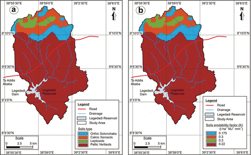
Soil loss was spatially correlated to the vegetation, slope, gradient, altitude, and rainfall. It is reasonable to understand that soil erosion is mostly dependent on the topography, runoff, and land-cover of the study area. In the present study area, four different types of soils were identified, these are pellic vertisols, orthic solonchaks, calcic xerosols, and leptosols (). Average annual soil losses for watershed were estimated for each grid cell (30 × 30 m). Results indicate that soil erodibility value in the study area ranges from 0.22 to 0.3 t ha−1MJ−1mm−1. It may be noted that the majority of the study area is covered by pellic vertisols (76.9%) with total area coverage of 16129.2 ha, as shown in ()). The rest of the area is covered by orthic solonchaks, calcic xerosols, and leptosols with an area coverage of 1889.5 ha (9%), 2076.3 ha (9.9%) and 868.8 ha (4.2%), respectively. The soil erodibility map of the study area is presented as ).
Table 3. Soil classes and respective Soil erodibility (K) factor value.
Figure 8. (a) Distribution of soil types, (b) Distribution of soil erodibility factor (K).
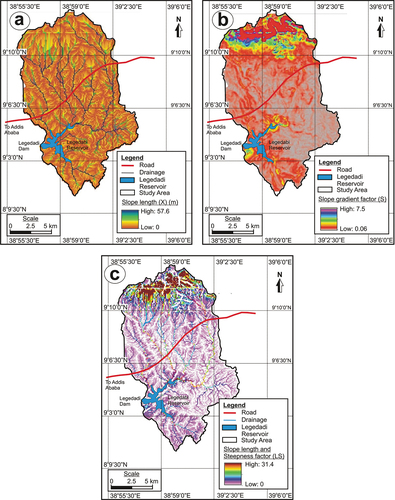
Slope length and steepness (LS) factor
The computed slope length (X), slope gradient (S), and LS factors for the present study area are presented in . The results clearly show that the slope length (X) values in the study area, in general, vary from 0 to 57.6 m whereas, the slope gradient (S) varies from 0.06 to 7.5. Further, the computed LS factor in the watershed ranged from 0 to 31.4, with the mean value for the entire watershed to be approximately 2.87 with ±3.0. The soil erosivity by runoff increases with the velocity of the runoff water on the steeper slopes. Thus, in steeper slopes, the runoff water will attain accelerated velocity, resulting in an increased shear force on the soil surface. Therefore the soil erosion and transportation capability of runoff water will be increased considerably.
Figure 9. (a) Slope length (X), (b) slope gradient (S), and (c) slope length and steepness (LS) factors.
Cover-management practice factor (C)
Land-use and land-cover map of the present study area ()) shows that about 44.6% of the total study area is occupied by the cultivated land followed by open grassland (39.3%), settlement (8.1%), forest (6.4%), and water body (1.6%). The classified land-use classes were verified by ground truth pixels. To perform quantitative classification accuracy assessment, the remote sensing derived classification data were compared with the reference test information data obtained from the field observation. The overall accuracy of land-use and land-cover classification was checked by the Kappa test, and k^ was found to be 94.1% and 0.91, respectively. Based on Hurni’s suggestion (Hurni, Citation1985a), for Ethiopian highlands, the C factor value was assigned to each land-use and land-cover class, as shown in (). The lowest C factor value was assigned for the water body (0), and the highest value was assigned for the settlement (0.99) ()). The areas with a high C factor value can be changed to enhance their infiltration by changing the cropping and surface management.
Table 4. Land-use/land-cover classes with respective Cover−management practice factor (C).
Figure 10. (a) Land-use/land-cover map, (b) Cover−management practice factor (C), and (c) Support practice factor (P).
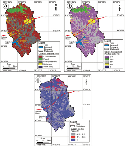
Support practice factor (P)
The permanent management is not practiced in the present study area, and thus no P factor values can be directly derived. For the present study, the P factor values as suggested by Wischmeier and Smith (Citation1978) were adopted. Accordingly, the P factor values were assigned for two land-use and land-cover classes: agricultural and all non-agricultural classes. All the non-agricultural land classes were assigned with a P factor value of 1. For the agricultural land class, the P factor values were classified into two; slope class I (P values, 0.11–0.12) and slope class II (P values; 0.14–0.31) (). The distribution of P factor classes in the study area is shown in ).
Table 5. P factor value for land-use and land-cover classes with respect to slope (Wischmeier & Smith, Citation1978).
Soil erosion estimation
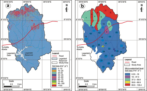
The Soil erosion estimates for the Legedadi watershed were made through the RUSLE model. The results show that the soil erosion in the study area ranges from 0 to17155.7 t ha−1 yr−1 with a mean annual soil loss of 24.55 t ha−1 y−1. The soil erosion/loss in the study area was divided into nine subclasses based on the amount of soil loss and the area coverage (). The perusal of results () indicates that 18343.7 ha of area, which is about 87.5% of the study area, has been estimated to have soil loss in between 0 to10 t ha−1 yr−1 and only 809.7 ha (3.9%) of the area may have soil loss more than 100 t ha−1 yr−1. The distribution of area with predicted annual soil loss in the study area is presented in ). With respect to the area distribution, the majority of the study area (87.5%) shows very low soil erosion (0 to10 t ha−1 yr−1), whereas high soil loss areas (>100 t ha−1 yr−1) are mainly distributed in the northern and north-eastern parts of the study area. Further, at a micro-watershed level, about 23 micro-watersheds show soil loss in the range of 0.53–18 t ha−1 yr−1. These micro-watersheds constitute about 69.8% of the total study area and are distributed in the southern, central, western, and eastern parts of the study area (). Four micro-watersheds (1, 2, 3, and 7) show relatively more soil loss, ranging between 69.9–138.4 t ha−1 yr−1. These micro-watersheds constitute about 13.6% of the total study area and are present in the northern parts ()).
Table 6. Soil erosion estimation in the study area.
Table 7. Soil erosion estimation at micro-watershed level in the study area.
Figure 11. Soil erosion estimation (a) overall study area, and (b) micro-watershed level.
Decision support system
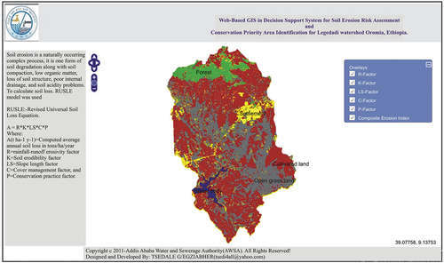
For adequate regional land planning, real-time data and information on the extent of soil erosion and erosion-prone areas are vital. However, such systematic information is not available in Ethiopia due to a lack of resources, poor data organization, and management. In the present study, a systematic methodology was followed firstly to estimate the soil erosion. Secondly, a web-based GIS decision Support System was developed to provide organized online information on soil erosion for the study area. The online system may help provide up-to-date information about soil erosion-prone areas that may facilitate the planners in decision-making for adequate regional land planning.
For the webGIS-based decision Support System, the user interface has been developed by using HTML and javascript. The first step required to access this system is to browse the Geo-server (http://localhost:8080/geoserver/web/), and later a workspace has to be created. Further, on the designed workspace by using the stored feature, a prepared map file was added. After this, the codes that were written in HTML and the Java scripts were built and run. Finally, by using any web browser, the application can be launched.
The Front End of the monitoring platform was designed to visualize the monitoring data by using any web browser, such as Internet Explorer, Firefox Mozilla, Google Chrome, etc. For soil data visualization, no extra installation of software is required. To run the application, the Front End system can be with good memory and adequate computational power and must support various spatial data formats such as; GeoJSON, Web Map Service, ESRI Shapefile, etc. Besides, it must support complex 3D models with reasonable file sizes. The developed webGIS-based soil loss information dissemination user interface is shown in . The Web-GIS monitoring platform can be accessed through any web browser.
Figure 12. Developed WebGIS-based soil loss information dissemination user interface.
Discussion
Soil erosion is a complex process that is influenced by various natural and human-induced factors (Tadesse et al., Citation2017). In the present study, the RUSLE model was used to estimate soil erosion in the study area. In selecting and implementing conservation measures for micro-watersheds, the concepts of soil loss tolerance and critical soil loss values can provide useful frameworks. Soil loss tolerance refers to the maximum soil loss that can occur from a given land without leading to soil degradation (Hurni, Citation1985a; Kinnell, Citation2000; Morgan, Citation2005). For conservation planning, soil loss tolerance values can be set at rates of soil formation. However, it is not practically possible to determine the rate at which soil loss equals soil formation quality (Abate, Citation2011). Different values of soil loss tolerance have been proposed by various sources (Morgan, Citation2005). However, a mean annual soil loss of 11 t ha−1 y−1 is generally considered acceptable, while it may be as low as 2 t ha−1 yr−1 in sensitive areas (Hudson, Citation1981). Further, Hurni (1985) suggested the maximum tolerable soil loss of 18 t ha−1 y−1, estimated for Ethiopia, except for flat landforms in the watershed. The results from the present study shows that the majority of the study area (87.5%) leads to very low soil erosion (0 to10 t ha−1 yr−1), whereas soil loss >10 t ha−1 yr−1 constitutes the remaining 12.5% of the study area. Also, the maximum tolerable soil loss limit (18 t ha−1 y−1) for Ethiopia, as Hurni (1985) suggested, is found in less than 9% of the study area. Further, at a micro-watershed level, about 23 micro-watersheds show soil loss in the range 0.53–18 t ha−1 yr−1. These micro-watersheds constitute about 69.8% of the total study area.
Soil erosion has been reported from many parts of Ethiopia and is considered significant on account of soil loss, which ultimately affects crop productivity. Increased soil erosion in different parts of Ethiopia has been reported in the works of Haregeweyn et al. (Citation2017), Tadesse et al. (Citation2017), and Atoma et al. (Citation2020). Further, an increase in the rate of soil erosion due to changes in rainfall patterns is reported in the works of Zerihuna et al. (Citation2018). They also showed changes in soil erosion rate due to changes in the slope of the area in the northwestern parts of Ethiopia. An increase in soil erosion and rainfall erosivity due to climate change is also observed in the other parts of the world, as reported in the studies by Simonneaux et al. (Citation2015) in Morocco and Maeda et al. (Citation2010) in Kenya. Besides, other studies also indicated the severity of the soil loss from different parts of Ethiopia. Amsalu and Mengaw (Citation2014) estimated soil loss to be 30.6 t ha−1 yr−1 in Jabi Tehinan District. The average erosion rate for agricultural land has been estimated to be about 40 t ha−1 y−1 in different parts of the region (Buzuayehu et al., Citation2002). Further, annual soil loss of 28.84 t ha−1 y−1 has been reported from the Awash basin (Atesmachew et al., Citation2010) and 26 t ha−1 yr−1 from the Wondo Genet watershed (Amare et al., Citation2014). From Dire Dam watershed, soil loss has been estimated to be 0.00 − 263.25 t ha−1 yr−1 with the mean annual soil loss rate of 58.3 t ha−1 y−1 (Israel, Citation2011).
Previous studies conducted on soil erosion assessment in Ethiopia show a different rate of soil erosion. According to the estimates made by FAO (Citation1984), the annual soil loss in the highlands of Ethiopia ranges from 1248–23400 million ton per year, estimated from 78 million of a hectare of pasture, ranges, and cultivated fields throughout Ethiopia. Thus, the soil erosion estimated by FAO (Citation1984) is equivalent to about 16 − 300 t ha−1 y−1. Another study conducted by Soil Conservation Research Program (SCRP) at Anjeni Research Station has revealed the annual soil loss rate to be 131 − 170 t ha−1 y−1 (Bono & Seiler, Citation1984; SCR, Citation1996). Further, the Awash River basin’s average annual soil loss has been estimated to be in the range of 200 − 300 t ha−1 y − 1 (PDRE, Citation1989).Thus, as assessed during the present study for the Legedadi watershed, the soil erosion falls in the range of 0.53–138.4 t ha−1 y − 1, which very well go in line with previous studies conducted in different parts of the country.
The web-based GIS decision Support System developed during the present study can provide systematic online information on soil erosion for the study area. The spatial soil erosion maps are placed online for the user’s visualization. The online system may help make decisions for soil conservation and may help to reduce soil erosion in critical regions. The online system may also provide up-to-date information about soil erosion-prone areas that may facilitate the planners’ decision-making for adequate regional land planning. Thus, this study may be useful for various natural resources-based applications.
For the present study, the RUSEL model was followed to estimate soil erosion. A general need was felt to modify and improve the equations to address the local environmental conditions for the specific characteristics of the parameters used in the model for the investigated watershed. Further, there is a need to calibrate the RUSEL model parameters to address relative changes in soil erosion under changing land use and climate patterns within an extended period and large spatial distribution of these changes. However, it was beyond the present study’s scope to conduct in-depth methodological differences on RUSLE parameters, assuming that this model’s pros and cons are well known and widely described in the literature. Thus, it is recommended that future researchers should consider the points mentioned above to make the necessary modifications in the RUSEL model.
Conclusion
Soil erosion is a severe environmental problem, particularly when high-intensity rainfall is recorded and poor land management is practiced. Soil erosion is a global issue with its significant impacts on the degradation of agricultural lands. In Ethiopia severity of the soil loss has been reported from different parts, particularly from the highlands. The present study was carried out to estimate the potential soil loss in the Legedadi watershed in Oromia Region, Ethiopia. A web-based Decision Support System (DSS) was also developed to provide online information on soil erosion in the study area. An empirical model was used to estimate the soil erosion in the present study area Revised Universal Soil Loss Equation (RUSLE). The factors that were used to compute the average soil loss are; rainfall-runoff erosivity (R), soil erodibility (K), slope length (L), slope steepness (S), cover-management practice (C), and conservation practice factor (P). Various secondary and primary data sources were used to generate the required data on multiple parameters; these include; remote sensing data, topographic maps, secondary data obtained from various Government organizations, and primary data collected from the field observations. The results indicate that the soil erosion in the present study area falls in the range 0.53–138.4 t ha−1 y − 1. The results also showed that the majority of the study area (87.5%) shows very low soil erosion (0 to10 t ha−1 yr−1), whereas soil loss >10 t ha−1 yr−1 constitutes to remaining 12.5% of the study area. Further, the online web-based Decision Support System (DSS) provides up-to-date information about soil erosion-prone areas that may facilitate the planners in decision-making for adequate regional land planning in the study area. The online system may also offer policy-makers options for managing soil erosion hazards most efficiently by prioritizing regions of interest. The methodology used in the present study can be applied in other parts of the country. Region-wise, similar web-based decision support systems for soil erosion monitoring and land conservation strategies may develop at the regional level.
Disclosure of potential conflicts of interest
The authors declare that they have no competing interests.
Acknowledgments
We are thankful to the head and staff of the School of Earth Sciences, College of Natural and Computational Sciences, Addis Ababa University, for providing all kinds of necessary facilities and support during the present study. We are also thankful to Addis Ababa Water and Sewerage Agency for providing all the essential data required for the present study. We even thankfully acknowledge data support from National Metrological Service Agency. The authors would also like to thank the reviewers for suggesting numerous improvements.
References
- Abate, S. (2011). Estimating soil loss rates for soil conservation planning in Borena Woreda of South Wollo Highlands, Ethiopia. Clarion. Journal of Sustainable Development in Africa, 13(3), 87–106.
- Alesheikh, A., Helali, H., & Behroz, H. A. (2002). Web GIS: Technologies and its applications. In Symposium on geospatial theory, processing and applications, XXXIV Part 4, ISPRS commission IV. Ottawa, Canada.
- Alexandridis, T. K., Sotiropoulou, A. M., Bilas, G., Karapetsas, N., & Silleos, N. G. (2015). The effects of seasonality in estimating the C-factor of soil Erosion studies. Land Degradation & Development, 26(6), 596–603. https://doi.org/10.1002/ldr.2223
- Amare, S., Nega, C., Zenebe, G., Goitom, T., & Alemayoh, T. (2014). Landscape–scale Soil erosion modeling and risk mapping of mountainous areas in eastern escarpment of Wondo Genet Watershed, Ethiopia. International Research Journal of Agricultural Science and Soil Science, 4(6), 107–116. https://doi.org/10.14303/irjas.2014.040
- Amdihun, A., Gabremariam, E., Rebelo, L., & Zeleke, G. (2014). Modeling soil erosion dynamics in Blue Nile (Abay) basin. Landscape approach. Research Journal of Environmental Sciences, 8(5), 243–258. https://doi.org/10.3923/rjes.2014.243.258
- Amsalu, T., & Mengaw, A. (2014). GIS based soil loss estimation using RUSLE model: The case of Jabi Tenan Woreda, ANRS. Ethiopia. Natural Resources, 5(11), 616–626. http://dx.doi.org/10.4236/nr.2014.511054
- Angima, A. D., Stott, D. E., O’Nell, M. K., Ong, C. K., & Weesies, G. A. (2003). Soil erosion prediction using RUSLE for central Kenyan Highland conditions. Agriculture, Ecosystems & Environment, 97(1–3), 295–308. https://doi.org/10.1016/S0167-8809(03)00011-2
- Arnold, J. G., Srinivasan, R., Muttiah, R. S., & Williams, J. R. (1998). Large area hydrologic modeling and assessment Part I: Model development. Journal of the American Water Resources Association, 34(1), 73–89. https://doi.org/10.1111/j.1752-1688.1998.tb05961.x
- Atesmachew, B., Taddese, G., & Gethahun, Y. (2010). Application of GIS for modeling Soil loss rate in Awash River Basin, Ethiopia. International Livestock Research Institute (ILRI).
- Atoma, H., Suryabhagavan, K. V., & Balakrishnan, M. (2020). Soil erosion assessment using RUSLE model and GIS in Huluka watershed, Central Ethiopia. Sustainable Water Resources Management, 6(1), 12. https://doi.org/10.1007/s40899-020-00365-z
- Ayele, K. F., Suryabhagavan, K. V., & Sathishkumar, B. (2014). Assessment of habitat changes in Holeta Watershed, Central Oromiya, Ethiopia. International Journal of Earth Sciences and Engineering, 7(4), 1370–1375. doi:10.21276/ijee
- Belayneh, M., Teshome Yirgu, T., & Tsegaye, D. (2019). Potential soil erosion estimation and area prioritization for better conservation planning in Gumara watershed using RUSLE and GIS techniques. Environmental Systems Research, 8(1), 20. https://doi.org/10.1186/s40068-019-0149-x
- Bono, R., & Seiler, W. (1984). Erodibility in the Suke-Harerge and Andit Tid Research Units (Ethiopia) (Research Report 5. Soil Conservation Research Project (SCRP)). Centre for Development and Environment, University of Berne.
- Buzuayehu, T., Gezahegn, A., Yigezu, A., Jabbar, M. A., & Paulos, D. (2002). Nature and causes of land degradation in the Oromiya Region (Socio-economics and Policy Research Working Paper 36). Addis Ababa: ILRI.
- Byong-Lyol, L., Young-Chan, K., & Jin, I.Y. (1998). Web interface for GIS in Agriculture. Agricultural Information Technology in Asia and Oceania. 107−107
- Carver, S. (2001). Public participation using Web-based GIS. Environment and Planning. B, Planning & Design, 28(6), 803–804. https://doi.org/10.1068/b2806ed
- De Roo, A. P. J., Wesseling, C. G., & Ritsema, C. J. (1996). Lisem: A single-event physically based hydrological and soil erosion model for drainage basins. I: Theory, input and output. Hydrological Processes, 10, 1107–1117. https://doi.org/10.1002/(SICI)1099-1085(199608)10:8<107:aid-hyp415>3.0.CO;2-4.
- Desmet, P. J. J., & Govers, G. (1996). A GIS-procedure for the automated calculation of the USLE LS factor on topographically complex landscape units. Journal of Soil and Water Conservation, 51(5), 427–433.
- Endalkachew, G. (2012). Climate change impact on surface water sources of Addis Ababa a case study in legedadi-dire-gefersa catchments and reservoirs [MSc Thesis]. Addis Ababa University.
- Erdogan, E. H., Erpul, G., & Bayramin, I. (2007). Use of USLE/GIS methodology for predicting soil loss in a semiarid agricultural environment. Environmental Monitoring and Assessment, 131(1–3), 153–161. https://doi.org/10.1007/s10661-006-9464-6
- FAO. (1984). Ethiopian Highland reclamation Study (EHRS) (Final Report), Rome. 1-2.
- FAOUN. (2015). Food and agriculture organization of the United Nations, 2015 (Status of the World’s Soil Resources), FAO, Rome.
- Fayas, C. M., Nimal, S. A., Nirmanee, K. G. S., Samaratunga., D., & Mallawatantri, A. (2019). Soil loss estimation using rusle model to prioritize erosion control in KELANI river basin in Sri Lanka. International Soil and Water Conservation Research, 7(2), 130–137. https://doi.org/10.1016/j.iswcr.2019.01.003
- Foley, J. (2017). Living by the lessons of the planet. Science, 356(6335), 251–252. https://doi.org/10.1126/science.aal4863.
- Fu, B. J., Zhao, W. W., Chen, L. D., Zhang, Q. J., Lü, Y. H., Gulinck, H., & Poesen, J. (2005). Assessment of soil erosion at large watershed scale using RUSLE and GIS: A case study in the Loess Plateau of China. Land Degradation & Development, 16(1), 73–85. https://doi.org/10.1002/ldr.646
- Fullen, M. A. (2003). Soil erosion and conservation in northern Europe. Progress in Physical Geography: Earth and Environment, 27(3), 331–358. https://doi.org/10.1191/0309133303pp385ra.
- Ganasri, B. P., & Ramesh, H. (2016). Assessment of soil erosion by RUSLE model using remote sensing and GIS-A case study of Nethravathi Basin. Geoscience Frontiers, 7(6), 953–961. https://doi.org/10.1016/j.gsf.2015.10.007
- Gebreyesus, B., & Kirubel, M. (2009). Estimating Soil Loss Using Universal Soil Loss Equation (USLE) for Soil Conservation planning at Medego Watershed, Northern Ethiopia. Journal of American Science,5(1), 58−69.
- Gete, Z. (2000). Landscape dynamics and soil erosion process modeling in the North Western Ethiopia Highlands. African Studies Series, University of Berne.
- Gobin, A., Jones, R., Kirkby, M., Campling, P., Govers, G., Kosmas, C., & Gentile, A. (2004). Indicators for pan-European assessment and monitoring of soil erosion by water. Environmental Science & Policy, 7(1), 25–38. http://dx.doi.org/10.1016/j.envsci.2003.09.004
- Grimm, M., Jones, R. J. A., Rusco, E., & Montanarella, L. (2003). Soil erosion risk in Italy: A revised USLE approach. Luxembourg (Europe): Office for official publications of the European Communities (European Soil Bureau Research Report No), Luxembourg 11. EUR 20677 EN, 26.
- Haile, G. W., & Fetene, M. (2012). Assessment of soil erosion and hazard in Kilie catchment, East Shoa, Ethiopia. Land Degradation & Development, 23(3), 293–306. https://doi.org/10.1002/ldr.1082
- Haregeweyn, N., Tsunekawa, A., Poesen, J., Tsubo, M., Meshesha, D. T., Fenta, A. A., Nyssen, J., & Adgo, E. (2017). Comprehensive assessment of soil erosion risk for better land use planning in river basins: Case study of the Upper Blue Nile River. Science of the Total Environment, 574, 95–108. https://doi.org/10.1016/j.scitotenv.2016.09.019
- Helden, U. (1987). An assessment of woody biomass, community forests, land use and soil erosion in Ethiopia. Lund: Lund University Press.
- Hudson, N. W. (1981). Soil conservation (2nd ed.). Batsford.
- Hurni, H. (1985a). Soil conservation manual for Ethiopia. Ministry of Agriculture.
- Israel, T. (2011). Soil Erosion Risk Assessment with RUSLE and GIS in Dire Dam Watershed [MSc thesis]. Addis Ababa University.
- Jayasekara, M. J. T. M., Kadupitiya, H. K., & Vitharana, U. W. A. (2018). Mapping of soil erosion hazard zones of SriLanka. Tropical Agricultural Research, 29(2), 135–146. http://doi.org/10.4038/tar.v29i2.8284
- Jha, M. K., & Paudel, R. C. (2010). Erosion predictions by empirical models in a mountainous watershed in Nepal. Journal of Spatial Hydrology, 10(1), 89–102. https://scholarsarchive.byu.edu/josh/vol10/iss1/2
- Jiang, B. (2013). GIS-based time series study of soil erosion risk using the Revised Universal Soil Loss Equation (RUSLE) model in a micro-catchment on Mount Elgon, Uganda [Master degree thesis]. Department of Physical Geography and Ecosystems Science.
- Kaltenrieder, V. V. J. (2007). Adaptation and validation of the Universal Soil Loss Equation (USLE) for the Ethiopian Eritrean Highlands [MSc thesis]. University of Bern.
- Kebede, Y. S., Endalamaw, N. T., Sinshaw, B. G., & Atinkut, H. B. (2021). Modeling soil erosion using RUSLE and GIS at watershed level in the upper beles, Ethiopia. Environmental Challenges, 2, 1–10. https://doi.org/10.1016/j.envc.2020.100009
- Khosrowpanah, S., Heitz, L. F., & Michael, P. (2007). Developing a GIS-based erosion potential model for Ugum Watershed (Technical Report No. 117), p. 96923. Water and Environmental Research Institute (WERI) of the Western Pacific, University of Guam, Mangilao.
- Kiflu, G. (2010). GIS-based conservation priority area identification in Mojo River watershed on the basis of erosion risk [MSc. Thesis]. Addis Ababa University.
- Kinnell, P. I. A. (2000). AGNPS-UM: Applying the USLE-M within the agricultural non-point source pollution model. Environ. Environmental Modelling and Software, 15(3), 331–341. https://doi.org/10.1016/S1364-8152(00)00002-5
- Kinnell, P. I. A. (2010). Event soil loss, runoff and the universal soil loss equation family of models: A review. Journal of Hydrology, 385(1), 384–397. https://doi.org/10.1016/j.jhydrol.2010.01.024
- Kouli, M., Soupios, P., & Vallianatos, F. (2009). Soil erosion prediction using the Revised Universal Soil Loss Equation (RUSLE) in a GIS framework, Chania, Northwestern Crete, Greece. Environmental Geology, 57(3), 483–497. https://doi.org/10.1007/s00254-008-1318-9
- Laflen, J. M., Foster, G. R., & Onstad, C. A. (1985). Simulation of individual strom soil loss for modeling the impact of soil erosion on crop productivity. In S. A. El-Swaify, W. C. Moldenhauer, & A. Lo (Eds.), Soil erosion and conservation. Soil Conservation Society of America.
- Lal, R. (2001). Soil degradation by erosion. Land Degradation & Development, 12(6), 519–539. https://dx.doi.org/10.1002/ldr.472
- Lazzari, M., Gioia, D., Piccarreta, M., Danese, M., & Lanorte, A. (2015). Sediment yield and erosion rate estimation in the mountain catchments of the Camastra artificial reservoir (Southern Italy): A comparison between different empirical methods. Catena, 127, 323–339. https://doi.org/10.1016/j.catena.2014.11.021
- Leica Geosystems. (2003). ERDAS imagine field guide (7th ed.), GIS and Mapping LLC, Atlanta.
- Maeda, E. J., Clark, B. J. F., Pellikka, P. K. F., & Siljander, M. (2010). Modeling agricultural expansion in Kenya’s Eastern Arc mountains biodiversity hotspot. Agricultural Systems, 103(9), 609–620. https://doi.org/10.1016/j.agsy.2010.07.004
- Maurya, S., Srivastava, P. K., Yaduvanshi, A., Anand, A., Petropoulos, G. P., Zhuo, L., & Mall, R. K. (2021). Soil erosion in future scenario using CMIP5 models and earth observation datasets. Journal of Hydrology, 594, 125851. https://doi.org/10.1016/j.jhydrol.2020.125851
- McCarty, B. (1999). Learning Debian GNU-Linux. no. September. 1999. O'Reilly & Associates.
- Millward, A. A., & Mersey, J. E. (1999). Adapting the RUSLE to model soil erosion potential in a mountainous tropical watershed. Catena, 38(2), 109–129. https://dx.doi.org/10.1016/S0341-8162(99)00067-3
- Mitasova, H., Hofierka, J., Zlocha, M., & Iverson, L. R. (1996). Modelling topographic potential for erosion and deposition using GIS. International Journal of Geographical Information Systems, 10, 629–641. https://doi.org/10.1080/02693799608902101
- Mitasova, H., Mitas, L., & Brown, W. M. (1995). Modeling spatial and temporally distributed phenomena: New methods and tools for GRASS GIS. International Journal of Geographical Information Science, 9, 443–446. https://doi.org/10.1080/02693799508902048
- Moges, D. M., & Bhat, H. G. (2017). Integration of geospatial technologies with RUSLE for analysis of land use/cover change impact on soil erosion: Case study in Rib watershed, north-western highland Ethiopia. Environmental Earth Sciences, 76(22), 765. https://doi.org/10.1007/s12665-017-7109-4
- Molla, T., & Sisheber, B. (2017). Estimating soil erosion risk and evaluating erosion control measures for soil conservation planning at Koga watershed in the highlands of Ethiopia. Solid Earth, 8(1), 13–25. https://doi.org/10.5194/se-8-13-2017
- Montanarella, L. (2015). Agricultural policy: Govern our soils. Nature, 528(7580), 32–33. https://doi.org/10.1038/528032a
- Morgan, R. P. C. (1995). Soil erosion and conservation. Addison-Wesley Longman. https://doi.org/10.1038/528032a
- Morgan, R. P. C. (2005). Soil erosion and conservation (3rd ed.). Blackwell Publishing.
- Nasiri, M. (2013). GIS modelling for locating the risk zone of soil erosion in a deciduous forest. Journal of Forest Science, 59(No. 2), 87–91. https://doi.org/10.17221/71/2012-JFS
- Nyssen, J., Poesen, J., Moeyersons, J., Deckers, J., Haile, M., & Lang, A. (2004). Human impact on the environment in the Ethiopian and Eritrean highlands−a state of the art. Earth-Science Reviews, 64(3–4), 273–320. https://doi.org/10.1016/S0012-8252(03)00078-3
- Opeyemi, O. A., Abidemi, F. H., & Victor, O. K. (2019). Assessing the impact of soil erosion on residential areas of Efon-Alaaye Ekiti, Ekiti-State, Nigeria. Journal of Environmental Planning and Management, 5, 23–31.
- Ostovari, Y., Moosavi, A. A., Mozaffari, H., & Pourghasemi, H. R. (2021). RUSLE model coupled with RS-GIS for soil erosion evaluation compared with T value in Southwest Iran. Arabian Journal of Geosciences, 14(2), 110. https://doi.org/10.1007/s12517-020-06405-4
- Ozdilek, D., & Seker, Z. (2004). A Web-Based Application for Real-Time GIS, ITU, Civil Engineering Faculty, 80626. Maslak Istanbul.
- Pandey, S., Gunn, R., Lim, K. J., Engel, B., & Harbor, J. (2000). Developing a web-enabled tool to assess long-term hydrologic impacts of land-use change: Information technology issues and a case study. Urban and Regional Information Systems Journal, 12(4), 5–17.
- Paulos, D. (2001). Soil and water resources and degradation factors affecting their productivity in the Ethiopian highland agro-ecosystems. Michigan State University Press, 8, 1–18.
- PDRE. (1989). Peoples democratic Republic of Ethiopia (PDRE). Master plan for the development of surface water resources in the Awash Basin (Final Report, 6). Ethiopian Valleys Development Studies Authority.
- Pimentel, D., Harvey, C., Resosudarmo, P., Sinclair, K., Kurz, D., McNair, M., Crist, S., Shpritz, L., Fitton, L., Saffouri, R., & Blair, R. (1995). Environmental and Economic Cost of Soil Erosion and Conservation Benefits. 24;267(5201):1117–23. doi:10.1126/science.267.5201.1117
- Prasuhn, V., Liniger, H., Gisler, S., Herweg, K., Candinas, A., & Clément, J. (2013). A high-resolution soil erosion risk map of Switzerland as strategic policy support system. Land Use Policy, 32, 281–291. https://doi.org/10.1016/j.landusepol.2012.11.006
- Qin, W., Guo, Q., Cao, W., Yin, Z., Yan, Q., Shan, Z., & Zheng, F. (2018). A new RUSLE slope length factor and its application to soil erosion assessment in a Loess Plateau watershed. Soil & Tillage Research, 182, 10–24. https://doi.org/10.1016/j.still.2018.04.004
- Raclot, D., Le Bissonnais, Y., Louchart, X., Andrieux, P., Moussa, R., & Voltz, M. (2009). Soil tillage and scale effects on erosion from fields to catchment in a Mediterranean vineyard area. Agriculture, Ecosystems & Environment, 134(3–4), 201–210. https://doi.org/10.1016/j.agee.2009.06.019
- Renard, K. G., Foster, G. R., Weesies, G. A., McCool, D. K., & Yoder, D. C. (1997). Predicting soil erosion by water: A guide to conservation planning with the Revised Universal Soil Loss Equation (RUSLE) (Agriculture Handbook N.703. U.S). Department of Agriculture Research Service.
- Rose, C. W., Yu, B., Hogarth, W. L., Okom, A. E. A., & Ghadiri, H. (2003). Sediment deposition from flow at low gradients into a buffer strip-a critical test of re-entrainment theory. Journal of Hydrology, 280(1–4), 33–51. https://doi.org/10.1016/S0022-1694(03)00184-7
- SCR. (1996). Soil conservation research project database report 1982−1993. Ministry of Agriculture and University of Berne, Series report III, Hundelafto Research Unit. Institute of Geography, University of Berne.
- Sharma, A. (2010). Integrating terrain and vegetation indices for identifying potential soil erosion risk area. Geo-Spatial Information Science, 13(3), 201–209. https://doi.org/10.1007/s11806-010-0342-6
- Shim, J. P., Warkentin, M., Courtney, J. F., Power, D. J., Sharda, R., & Carlsson, C. (2002). Past present and future of decision support technology. Decision Support Systems, 33(2), 111–126. https://doi.org/10.1016/S0167-9236(01)00139-7
- Simonneaux, V., Cheggour, A., Deschamps, C., Mouillo, F., Cerdan, O., & Bissonnais, Y. (2015). Land use and climate change effects on soil erosion in semi-arid mountains watershed (High Atlas, Morocco). Journal of Arid Environments, 22, 64–75. https://doi.org/10.1016/j.jaridenv.2015.06.002
- Singh, M., & Hartsch, K. (2019). Basics of Soil Erosion. In Watershed Hydrology, Management and Modeling, CRC Press, Boca Raton, 1–61. https://doi.org/10.1201/9780429430633
- Suryabhagavan, K. V. (2017). GIS-based climate variability and drought characterization in Ethiopia over three decades. Weather and Climate Extremes, 15, 11–23. https://doi.org/10.1016/j.wace.2016.11.005
- Tadesse, L., Suryabhagavan, K. V., Sridhar., G., & Gizachew, L. (2017). Land use and land cover changes and soil erosion in Yezat watershed, north western Ethiopia. International Soil and Water Conservation Research, 5(2), 85–94. https://doi.org/10.1016/j.iswcr.2017.05.004
- Thapa, P. (2020). Spatial estimation of soil erosion using RUSLE modeling: A case study of Dolakha district, Nepal. Environmental Systems Research, 9(1), 15. https://doi.org/10.1186/s40068-020-00177-2
- Trenberth, K. E. (2011). Changes in precipitation with climate change. Climate Research, 47(1–2), 123–138. https://doi.org/10.3354/cr00953
- Van der Knijff, J. M., Jones, R. J. A., & Montanarella, L. (2000). Soil erosion risk assessment in Italy (Report No EUR 19044 EN). Office for Official Publications of the European Communities.
- Wischmeier, W. H. (1959). A rainfall erosion index for a universal soil loss equation. Soil Science Society of America Journal, 23(3), 246–249. https://doi.org/10.2136/sssaj1959.03615995002300030027x
- Wischmeier, W. H., & Smith, D. D. (1978). Predicting rainfall erosion losses. A guide to conservation planning (USDA Agriculture Handbook n. 537). Washington, DC.
- Woldamlak, B., & Teferi, E. (2009). Assessment of soil erosion hazard and prioritization watershed, Blue Nile basin, Ethiopia. Published online in Wiley Inter Science. www.interscience.wiley.com
- Yang, C., Wong, D. W., Yang, R., Kafatos, M., & Li., Q. (2005). Performance‐improving techniques in web‐based GIS. International Journal of Geographical Information Science, 19(3), 319–342. https://doi.org/10.1080/13658810412331280202
- Yesuph, A. Y., & Dagnew, A. B. (2019). Soil erosion mapping and severity analysis based on RUSLE model and local perception in the Beshillo Catchment of the Blue Nile Basin, Ethiopia. ?Environmental System Research, 8(17). https://doi.org/10.1186/s40068-019-0145-1
- Zerihuna, M., Mohammed, S. M., Demeke, S., Anwar, A. A., & Mindesilew, L. (2018). Assessment of soil erosion using RUSLE, GIS and remote sensing in NW Ethiopia. Geoderma Regional, 12, 83–90. https://doi.org/10.1016/j.geodrs.2018.01.002