
ABSTRACT
Provision of water to wildlife is critical during drought periods in Protected Areas (PA). The objectives of the study were to: (i) assess the distribution of artificial and natural water sources, (ii) assess if there is any relation between borehole depths and borehole water yields, and (iii) assess rainfall trends in relation to borehole yields in Mid Zambezi Protected Area (PA). A combination of remote sensing, water divining, borehole drilling, and visual observations was used to collect data in four PAs in Mid Zambezi in November 2019. Drilled boreholes had mean depths of 74 metres. There were no significant differences in borehole depths and boreholes water yield, Borehole depth: (Kruskal-Wallis χ2 test = 10,8, df = 9, p > 0.05) and borehole water yield Kruskal-Wallis χ2 test = 7,3, df = 11, p > 0.05). A negative correlation was recorded between the boreholes depth and borehole water yields (r = −0.32, n = 18, p < 0.05). The gradual decline in rainfall in the Zambezi valley was ascertained to be related to low borehole water yields and increased borehole depths in some PA. The study recommends another study on the perceived negative impacts of artificial water sources in the wildlife ecosystem.
1. Introduction
In arid habitats, the scarcity of natural water has long been considered a limiting factor for many large herbivores species (Roberts, Citation1977). Artificial provision of water for wildlife in Protected Area (PA), usually from drilled boreholes, is increasingly common in Southern Africa. Climate change which is associated with recurring droughts has greatly affected natural water availability in PA. The idea of placing artificial water sources like boreholes, dams and weirs in the Zimbabwe PA (e.g., Hwange) was implemented by the Zimbabwe Parks and Wildlife Management Authority and other NGOs in the early 1980s. Artificial game water supply was done to reduce dry season wildlife mortality, attract animals for game viewing or hunting and to reduce large herbivores concentration at the permanent water bodies, especially of the large herbivores (e.g., elephants and buffalos) (Chamaillé-Jammes et al., Citation2007; Child, Citation1972).
Droughts have a severe impact on rivers, dams, surface, and underground water sources. Drought changes water flow in rivers and springs and these changes can be severe in Savanna ecosystems (Nash, Citation2015). Changes in rivers and streamflow affect aquatic species movement, reproduction, and ability to orient for effective navigation (Williams, Citation2006). Besides, flow and water surface changes, drought affect the lifecycles and abundance of insects and other invertebrates which are a crucial part of the ecosystem (Harper & Peckarsky, Citation2006; Sanchez & Haderlie, Citation1990). In extreme cases, drought can trigger wildfires which destroy ground cover (Kershner et al., Citation2003; U.S. Environmental Protection Agency, Citation2014), burned forests are made prone to flooding as they will not able to hold back excess waters thus increasing severe soil erosion and siltation of water sources (Kershner et al., Citation2003; Williams, Citation2006). Apart from that, a geological study in Mid Zambezi indicated variations in the quantity of underground water.
The development of artificial water sources helps to prevent the migration of animals to high-level poaching areas and helps to reduce Human-Wildlife Conflicts (Epaphras et al., Citation2007; Kindschy, Citation1996). Spreading water sources help to reduce species competition thus reducing overgrazing at natural points and stabilizing the ecosystem (Epaphras et al., Citation2007; Fritz et al., Citation2003). However, artificial game water supply is associated with increased risk of predation around the water sources, stagnant water poses a risk of diseases spreading and serious vegetation destruction around the water sources. Wildlife water provision has received serious analysis and wildlife managers have queried if there is a need to have more artificial wildlife water sources (Rosenstock et al., Citation1999). Artificial game water supply is associated with wildlife population increase as there will be reduced mortalities and this alters ecosystems’ carrying capacities. Conservationists who oppose artificial water game water supply have argued that the costs of establishment of such water sources may not yield expected benefits (Brown, Citation1998; Fritz et al., Citation2003; Rosenstock et al., Citation1999). Our study contributes to an understanding of the impact of drought on the surface and underground water in wildlife PA. The objectives of the study were to: (i) assess the distribution of artificial and natural water sources during the drought period, (ii) assess the relation between borehole depths and borehole water yields, and (iii) assess rainfall trends in relation to borehole yields.
2. Methods
2.1 Study area
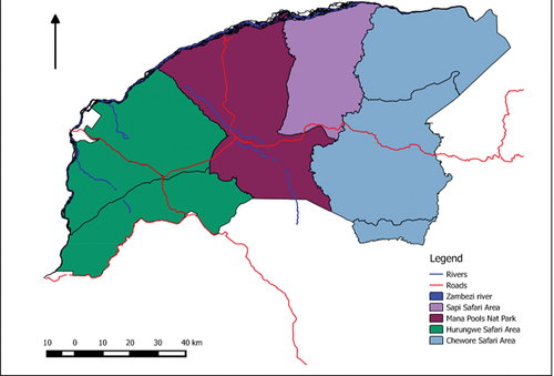
Mid Zambezi PA has several Safari areas (Hurungwe, Chewore, Sapi) and one National Park (Mana Pools) (). The area is situated in northernmost Zimbabwe between 35k 692,505 utm 8,174,689 and 35k 856,908 utm 8,256,000. The area is bounded by the Zambezi River on the North, Charara Safari area to the East, and Dande Safari Area to the West. The PA shares boundaries with several communal areas to the southern part, i.e. Nyamakate, Chundu, and Kazangarare. The Zambezi escarpment divided the area into two distinct zones, i.e., Zambezi Valley (areas below Zambezi escarpment) and high-altitude area (area above Zambezi escarpment). The area falls within natural region 4 with an average annual rainfall of 650 received between November and April as well as 20°C and 38°C winter and summer maximum temperatures respectively (Dunham, Citation1986; Fritz et al., Citation2003). The areas below the Zambezi escarpment have deep, brown to reddish, medium-textured soils while the area above Zambezi escarpment shallow, pre-Cambrian granites and gneisses rocks as well as clay loamy soils in some spots (Dunham, Citation1986). The mountain and hilltops areas support open Miombo Woodland which is dominated by Julbernardia globiflora, Brachystegia speciformis (Zebrawood), Brachystegia bohemii (Prince of Wale Feathers), Brachystegia glaucescens (mountain acacia), Kirkia acuminata, Sterculia quinqueloba and Commiphora sp (Dunham, Citation1986). The area is endowed with big four which include the Loxodonta Africana (elephant), Syncerus caffer (Buffalo), Panthera Leo (Lion) and Panthera Pardus (Leopard). There are other several mammals, birds, fish, reptiles and insects which are found in this study area.
Figure 1. Location of study sites within Mid Zambezi PA, northern Zimbabwe.
2.2 Data collection
The observation of artificial and natural water holes was made in November 2019 within Mid Zambezi PA. Data for only major perennial natural water holes, springs, and rivers were collected as natural water sources and data for sites with drilled boreholes was recorded as an artificial water source. Water availability or unavailability was the major parameter that was assessed. The sites which were detected by an experienced water diviner to yield high water at a low depth were recorded as the confirmed borehole site. The depth at which the water drilling rig reached water was recorded in metres as the depth of the borehole. The installed submersible solar-powered water pumps were used to estimate the borehole water yield. A hand-held Global Positioning System (GPS) Model (Garmin eTrex) was used to collect coordinates for artificial and natural water sources were found and the coordinates were converted to a comma-separated value file before exported to Quantum Geographical Information System (QGIS) Version 2.4.0-Chugiak. Secondary data on annual rainfall trends were obtained for the past five years from weather stations within each PA.
2.3 Data analysis
Descriptive statistics were used to summarise the collected data. QGIS was used to map the distribution of artificial and natural water sources within Mid Zambezi PA. A Kruskal-Wallis χ2 test was used to analyse if there were any significant differences in borehole depths from one PA to the other. Pearson product-moment correlation coefficient was used to determine the relationships between: (i) annual rainfall and natural water holes that had water and (ii) rainfall and the depth at which water was found from the drilled boreholes. Where appropriate, analyses were conducted using the Statistical Package for Social Sciences (SPSS) version 20 for Windows (IBM SPSS Inc., Chicago, USA).
3. Results
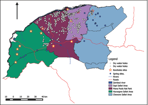
A total of 21 boreholes and 32 springs were recorded and they were supplying game water. The distribution of boreholes was as follows: Hurungwe Safari area-6, Mana Pools National Park-11, Sapi Safari Area-3, Chewore Safari area-1 and springs were as follows, Hurungwe Safari area-8, Mana Pools National Park-3, Sapi Safari Area-1, and Chewore Safari area-20 (). Most of the springs were observed on the southern part of the Mid Zambezi close to the Zambezi escarpment. Most boreholes were sited along the middle of the Zambezi valley (between Zambezi river and Zambezi escarpment). All big perennial natural water holes in Mid Zambezi were dry by November except the Mighty Zambezi River (). A fair distribution of water holes has been observed in Mana Pools and the Sapi Safari area.
Figure 2. Natural (spring sites) and artificial (borehole) water sources distribution during a drought year in Mid Zambezi.
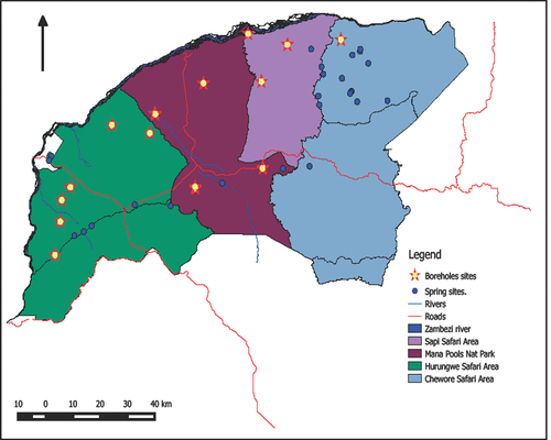
Figure 3. Distribution of natural water holes (dry) in relation to springs and borehole sites in Mid Zambezi.
The sampled 21 boreholes had mean depths of 74 metres with a depth range of 45 m to 86 m. The boreholes had a mean water yield of 1944 litres per hour (LPH) with a water yield range of 400 LPH to 6000 LPH (). No significant differences were recorded in borehole depths and boreholes water yield across the four sampled PA. Borehole depth: (Kruskal-Wallis χ2 test = 10,8, df = 9, p > 0.05) and borehole water yield Kruskal-Wallis χ2 test = 7,3, df = 11, p > 0.05). A negative correlation was recorded between the borehole depth and borehole water yields (r = −0.32, n = 18, p < 0.05). Most boreholes that had high depth yielded low water, for example, Site 3 in Hurungwe, Site 5 in Mana Pools National Park, and Site 3 in the Sapi Safari area ().
Figure 4. The relationship between boreholes depth and borehole water yield.
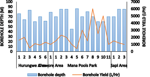
Table 1. Protected area borehole depth and borehole water yield (L/Hr).
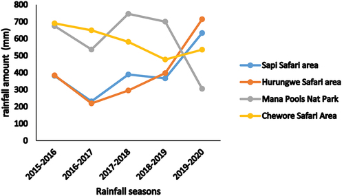
The 2016–2017 and 2018–2019 season recorded low rainfall in all PA (). The seasonal rainfalls were not stable as noted by sharp declines and increases. Chewore Safari area recorded four consecutive seasonal rainfall decline, i.e., from 2015–2020 while Hurungwe Safari area had four consecutive seasonal rainfall increase i.e., from 2016–2020 ().
Figure 5. Rainfall trends for five years in four protected areas.
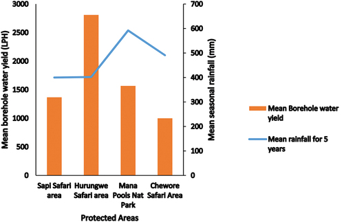
Chewore Safari area and Sapi Safari area recorded low mean borehole water yields and low mean seasonal rainfall (, ). However, Mana Pools National Park recorded high mean seasonal rainfall with low borehole water yield. Hurungwe Safari area recorded a high mean borehole water yield despite low mean seasonal rainfall ().
Figure 6. Mean seasonal rainfall in relation to mean borehole water yield in Mid Zambezi protected areas.
4. Discussion
Drilled boreholes were not well distributed across the four protected areas. Drilling boreholes in PA is a management intervention due to the needs and priority of some critical areas. Chewore Safari area had one borehole drilled and this could be due to reduced risk of water shortage to wildlife mainly because of increased natural water sources which are within the PA. Management intervention through borehole drilling could be driven by the mode of tourism within the PA. Non-consumptive tourism like photographic safaris requires more water sources for easy wildlife sighting and consumptive tourism like hunting, may not necessarily need more water sources. In this case, Mana Pools National Park and part of Hurungwe Safari Area-Rifa section, through management interventions, more boreholes were drilled to support the non-consumptive tourism. Natural springs were not fairly distributed within the Zambezi valley, most of the springs were located close to the Zambezi escarpment. Chewore Safari area had more natural springs which supplied water to wildlife. Geographically, the Chewore Safari area lies within the Zambezi Valley mountainous range. Springs are typically present where the water table intersects the land surface and fractured-rock terrain (Spechler & Schiffer, Citation1995).
All perennial natural water holes were dry in November 2019 due to the drought. Zambezi valley had been experiencing a general decline in rainfall and this could have forced the perennial natural water holes to run dry. There has been a gradual decline in rainfall between 2015 and 2019 in the Zambezi valley (). High temperatures in summer and increased water consumption from wildlife could also contribute to reduced surface water especially in areas with high wildlife concentrations (Jarman, Citation1972). There were no significant statistical differences in borehole depths and boreholes water yield across the four sampled PA. The study area falls within the same geological zone, i.e. Zambezi valley with the same climatic conditions and this could have minimised significant variations. However, a negative correlation was recorded between the boreholes depth and borehole water yields mainly because some boreholes were sunk deeper with anticipation to have high water yields as they drill deeper. In this study, a significant borehole water yield was not realised because in some cases, deep boreholes show an increase in water yield after a period of between 8 to 16 years periods after the precipitation (Epaphras et al., Citation2007).
5. Conclusion
Drought has a severe impact in affecting the natural water holes water-holding capacities in PA ecosystems. Besides aesthetic values, natural springs are critical sources of large herbivores water supply in PA. Adaptive management practices like drilling boreholes in some areas without water helps in the provision of game water supply. The study contends that artificial water sources are beneficial to the wildlife population in drought periods. This study has shown that there were no significant differences in borehole depths and boreholes water yield in Zambezi valley, however, more effort was exerted in drilling deep boreholes with anticipation to increase borehole water yields. The gradual decline in rainfall in the Zambezi valley was ascertained to be related to low water yields and increased borehole depths in some PA. The study recommends that effort should be invested in planning, monitoring, and managing the established artificial water sources and active measures to be developed to curb negative impacts to the natural environment.
Acknowledgments
We thank the Director-General of Zimbabwe Parks and Wildlife Management Authority (ZPWMA) for supporting the study, Senior Area Managers for Hurungwe Safari Area, Mana Pools National Park and Chewore Safari Area for facilitating logistics of the study and the Park staff for participating in the study, and Mushandike College of Wildlife Management Students (Milcent Chikara and Tinashe Chinyani) for assistance in field data collection.
Disclosure statement
The author(s) declare no competing interest.
Additional information
Funding
References
- Brown, D. E. (1998). Water for wildlife: Belief before science, p. 9–16. In: Environmental, economic, and legal issues related to rangeland water developments: Proceedings of a symposium, 13–15 Nov. 1997, Tempe, Ariz. Arizona State Univ. Coll. of Law.
- Chamaillé-Jammes, S., Valeix, M., & Fritz, H. (2007). Managing heterogeneity in elephant distribution: Interactions between elephant population density and surface-water availability. Journal of Applied Ecology, 44(3), 625–633. https://doi.org/10.1111/j.1365-2664.2007.01300.x
- Child, G. F. T. (1972). Water and its role in nature conservation and wildlife management in Botswana. Botswana Notes Rec, 4, 253–255.
- Dunham, K. M. (1986). Movements of elephant cows in the unflooded Middle Zambezi valley, Zimbabwe. African Journal of Ecology, 24(4), 287–29 I. https://doi.org/10.1111/j.1365-2028.1986.tb00372.x
- Epaphras, A. M., Gereta, E., Lejora, I. A., Ole Meing’ataki, G. E., Ng’umbi, G., Kiwango, Y., Mwangomo, E., Semanini, F., Vitalis, L., Balozi, J., & Mtahiko, M. G. G. (2007). Wildlife water utilization and importance of artificial waterholes during dry season at Ruaha National Park, Tanzania. Wetlands Ecology and Management. https://doi.org/10.1007/s11273-007-9065-3
- Fritz, H., Sonia, F., Pierre-Cyril, S., Snoden, R., Craig, M., & C& Francois, M. (2003). The effects of agricultural fields and human settlements on the use of rivers by wildlife in the Mid Zambezi valley, Zimbabwe. Landscape Ecology, 18(3), 293–302. https://doi.org/10.1023/A:1024411711670
- Harper, P., & Peckarsky, B. (2006). Emergence cues of a mayfly in a high-altitude stream ecosystem: Potential response to climate change. Ecological Applications, 16(2), 612–621. https://doi.org/10.1890/1051-0761(2006)016[0612:ECOAMI]2.0.CO;2
- Jarman, P. J. (1972). The use of drinking sites, wallows and salt licks by herbivores in the flooded middle Zambezi valley. African Journal of Ecology, 10(3), 197–201. https://doi.org/10.1111/j.1365-2028.1972.tb00727.x
- Kindschy, R. R. (1996). Fences, waterholes, and other range improvements. In P. R. Krausman (Ed.), Rangeland wildlife (pp. 369–381). Soc. for Range Manage.
- Nash, P. (2015). Mountain streams. Pagan Network. www.pagannetwork.org/forums/index.php?topic=26109.0
- Roberts, R. F. (1977). Big game guzzlers. Rangeman’s Journal, 4, 80–82.
- Rosenstock, S. S., Ballard, W. B., & Devos, J. C. (1999). Viewpoint: Benefits and impacts of wildlife water developments. Rangeland Ecology & Management/Journal of Range Management Archives, 52(4), 302–311. https://doi.org/10.2307/4003538
- Sanchez, J. E., & Haderlie, M. K. (1990). Water management on Cabeza Prieta and Kofa national wildlife refuges, p. 73–77. In: G. K. Tsukamoto & S. J. Stiver (eds.), Proc. Wildlife Water Development Symposium, 30 Nov.–1 Dec. 1988, Las Vegas, Nev. Nevada Chapter The Wildl. Soc., USDI BLM, and Nevada Dept. Wildl.
- Spechler, R. M., & Schiffer, D. M. (1995). Springs of Florida. USGS – Science for a changing world. U.S. Geological May 1995 Survey Fact Sheet FS-151-95.
- U.S. Environmental Protection Agency. (2014).
- Williams, J. (2006). Central valley salmon: A perspective on Chinook and steelhead in the central valley of California. San Francisco Estuary and Watershed Science 4: Art. 2.
- Kershner, J., MacDonald, L., Decker, L. M., Winters, D., & Libohova, Z. (2003). Ecological effects of the hayman fire – Part 6: Fire-induced changes in aquatic ecosystems. USDA. Forest Service General Technical Report: 232–243.