
ABSTRACT
Available empirical evidence about the impacts of large-scale agricultural investments (LAIs) in low-income countries is skewed towards the assessment of economic benefits. How LAIs affect land use and the environment is less understood. This study assesses how small-scale farmers living close to an LAI perceive the changes LAI's inflict on land use, land management, and tree cover in Kenya, Mozambique, and Madagascar. It also investigates their perceptions regarding LAI's impacts on the general environment and people's health, as well as on employment opportunities, infrastructure, and conflicts. 271 small-scale farmers were interviewed and their perceptions supported by a remote-sensing-based analysis of land use and land cover changes. Results show that LAIs contributed both directly and indirectly to deforestation in Mozambique, triggered changes in small-scale farmers’ agricultural land management in Kenya, and caused pastoralists to lose access to grazing land in Madagascar. Despite some benefits from employment opportunities and infrastructure improvement, the majority of respondents perceived the overall impacts of LAIs as negative, highlighting reduced access to land and water, pollution, health issues, and unsatisfactory working conditions. We urgently need to invest in devising concrete transformative options to improve LAIs’ contribution to sustainable development in their host countries.
EDITED BY:
1. Introduction
Since the 2008 food–energy–finance crisis, transformative pathways towards increasing low-income countries’ agricultural production and national income while simultaneously improving poor land users’ livelihoods and well-being have still not been found. Increasing demand for food from consumers in the global North, as well as the 2008 food price spikes (Margulis and McKeon Citation2013), have led both governments and private investors to increasingly put money into agriculture in low-income countries (Anseeuw et al. Citation2012; Cotula Citation2012). Investments come from around the globe, and their target areas are likewise dispersed throughout the world; most of them are located in Africa, Southeast Asia, Latin America, and Eastern Europe (Nolte et al. Citation2016).
Large-scale agricultural investments (LAIs) into what is often considered ‘idle’ or ‘underused’ land have been propagated as potential win–win situations that make it possible to meet various national-level development objectives (Collier and Dercon Citation2014). Unlike the Land Matrix Initiative (Nolte et al. Citation2016), we interpret the word ‘large-scale’ in ‘large-scale agricultural investments’ as referring not only to the size of the cultivated area, but also to economic size in terms of capital involved and labour employed. LAIs were specifically seen as a solution to rural poverty (The World Bank Citation2014). Accordingly, many African governments met this renewed interest in their agricultural sector with great optimism (The World Bank Citation2011; Cotula Citation2012). Indeed, several studies have shown that large investments in agriculture do have a certain positive effect on local communities’ livelihoods, for example through employment, newly generated livelihood opportunities, and the uptake of technological farming practices, or by improving access to agricultural inputs (Smaller et al. Citation2015; Deininger and Xia Citation2016).
However, with more empirical studies being done, scholars have increasingly been finding negative impacts of LAIs. In much of sub-Saharan Africa, land tenure regimes are organized through customary arrangements that are often poorly protected by statutory law. For this reason, growing commercial demand for farmland exposes rural populations to increased risks of involuntary displacement and dispossession of valuable livelihood resources (Schoneveld Citation2017). Recent research has documented adverse livelihood impacts of LAIs such as loss of housing and farmland (through forced resettlement) and loss of access to land and common-property resources like water, pasture, and non-timber forest products. These impacts increase people’s food and income insecurity, reduce their capacity to cope with shocks, and widen pre-existing inequalities intensifying social conflicts (German et al. Citation2011; Schoneveld et al. Citation2011; Ulrich Citation2014; Boamah and Overå Citation2016; Oberlack et al. Citation2016; Hufe and Heuermann Citation2017; Bottazzi et al. Citation2018). Further, LAIs are considered to be a major driver of deforestation and environmental degradation (Rudel et al. Citation2009; Gibbs et al. Citation2010; Davis et al. Citation2015; Magliocca et al. Citation2020). Many LAIs target small-scale farmers’ extensively cultivated mosaic croplands or areas of great ecological significance, such as wetlands, savannahs, and dry and tropical forests (Anseeuw et al. Citation2012; Eckert et al. Citation2017; Schoneveld Citation2017; Zaehringer et al. Citation2018a). Most LAIs are therefore environmentally unsustainable, as confirmed by a review of case studies in sub-Saharan Africa (Hufe and Heuermann Citation2017). Moreover, achieving a profitable and reliable production for the global market requires many LAIs to install modern irrigation schemes, adding pressure on scarce water resources especially in dryland contexts. Indeed, studies have shown that access to water resources is an important criterion in selecting LAI target areas (Rulli et al. Citation2013; Breu et al. Citation2016).
Nonetheless, the complex impacts that LAIs have on land use and the environment remain poorly understood. Most studies focus exclusively on direct impacts occurring at the sites where LAIs are implemented – for example, when diversified extensively used cropland is converted into intensively managed monoculture plantations. However, LAIs may also affect land use and associated ecosystem services indirectly, beyond the actual LAI site – for example, by displacing cropland into forested areas (Zaehringer et al. Citation2018a), polluting water resources (Muriithi and Yu Citation2015), or decreasing water availability further downstream (Zaehringer et al. Citation2018b). Empirical evidence of such off-site impacts is scarce, and particularly so with respect to land use and the environment; this is due to the difficulty of establishing the causality between changes observed at a spatially distant location and changes on the LAIs premises (Carlson et al. Citation2018; Meyfroidt et al. Citation2018). Assessing these links requires an interdisciplinary approach combining quantitative methods to measure and observe land use changes in space and time with a qualitative in-depth case study assessment.
The present study addressed this research gap by empirically investigating the consequences of LAI establishment in three African countries. As LAIs are entering rural areas dominated by small-scale land users, they are likely to affect people through changes in land use and the environment. We focused primarily on assessing how land users living close to an LAI perceive the changes LAI’s inflict on land use, land management, and tree cover. To verify and support their perceptions, we assessed land cover and land use change on the LAIs’ premises and in their surroundings using remotely sensed data. To complement our assessment, we also asked about land users’ perceptions regarding LAI’s impacts on the general environment and people’s health, as well as on employment opportunities, infrastructure, and conflicts. This helps to comprehend why land users might prefer LAIs to remain operational despite adverse environmental impacts. With our study, we provide novel evidence on the under-researched aspect of land use and environmental change in the context of large-scale investments on land in low-income countries. Broadening our understanding of the diverse ways in which LAIs affect land use and the environment is a prerequisite for eventually proposing and negotiating pathways that enable LAIs to improve their contributions to achieving the 2030 Agenda’s sustainable development goals (United Nations Citation2015).
2. Methods
2.1. Overall approach
We took an empirical, case-study based approach and focused on a specific number of LAI cases in each of the three project countries of Kenya, Mozambique, and Madagascar. Our aim was to assess how LAIs directly and indirectly lead to (1) land use change, (2) changes in land management, (3) tree cover change, and (4) how they affect wider aspects of sustainable development including employment, the environment, health, infrastructure, and conflicts. By land use, we mean the broader types of use of land, such as subsistence crop production, commercial crop production, or pasture; whereas land management includes the types of crops planted and technologies or practices applied to manage the land. We chose a mixed-methods approach, focusing on structured interviews with small-scale land users and supporting this with a remote-sensing-based analysis of land use and land cover change. According to our definition of LAI, in the context of this study, an LAI need not necessarily cover a large area if it involves a great amount of capital or has a large number of employees.
2.2. Study areas
Our study was part of the ‘African Food, Agriculture, Land and Natural Resource Dynamics, in the context of global agro-food-energy system changes (AFGROLAND)’ project, which aimed to understand how changes in the global agro–food–energy system affect countries in Africa. The project investigated the economic, social, and environmental impacts of changes in land use patterns driven by global development trends in Kenya, Mozambique, and Madagascar. In each country, we selected a number of LAIs for our in-depth assessment from a larger list of LAIs that had been inventoried in a first stage of the overall project. In total, we investigated 13 LAIs representing a variety of crops produced in the three countries. In Madagascar, the selection of LAIs was challenging. Many planned projects were abandoned before the start of production due to difficulties with land tenure, accessibility, political instability, and other issues; others went out of production after the 2008 food price crisis. Indeed, one of the two LAIs presented here abandoned production very shortly before we conducted our study. In Mozambique’s Monapo district, one of the sampled LAIs went bankrupt shortly after our study. We decided to present these cases nonetheless, as the highly dynamic nature of LAIs in Eastern Africa is an important aspect of this phenomenon of globalization, and we can learn from the impacts of failed LAIs for the future.
For the purpose of this synthesis effort, we aggregated the 13 LAIs into six cases for comparison based on a combination of the crops they produce and the administrative and climatic context in which they operate (, ). Cases 1 and 2 are situated in Kenya, in the upper Ewaso Ng’iro basin, including parts of Laikipia, Meru, and Nyeri counties. The climatic conditions range from semi-humid to semi-arid and arid (UNEP/GRID Citation2017). Two distinct rainy seasons determine the cropping calendar. The majority of the rural population are small-scale farmers; who own about two hectares of land per household on average (Wiesmann Citation2008; Ulrich et al. Citation2012), they practise a combination of crop farming and livestock keeping, mostly for subsistence but partly also for sale on local markets. Purely pastoral systems dominate in the drier areas. The presence of LAIs has increased considerably over the last 20 years (Eckert et al. Citation2017). They focus on producing either vegetables (e.g. runner beans, broccoli, kale) (Case 1) or flowers (Case 2), mostly for the export market. Only a small part of the vegetables is sold on the Kenyan market.
Table 1. Case study characteristics and overview of methods applied
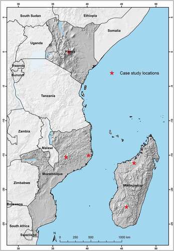
Figure 1. Overview of the study area in Kenya, Mozambique, and Madagascar, showing the approximate locations of the cases
Cases 3 and 4 are located in Mozambique, in the west and east of the Nacala corridor, in Guruè and Monapo districts, respectively. They represent two different agroecological zones. While Guruè has a temperate climate, Monapo has a semi-arid to subhumid one (The World Bank Citation2006). The mountainous, temperate areas of Guruè have been used for tea plantations – Mozambique’s largest – since colonial times. The area has attracted different types of agricultural investors since around 2003 (Joala et al. Citation2016). Local production systems have changed tremendously since non-governmental organizations (NGOs) and aid agencies began to promote soybeans (Di Matteo et al. Citation2016). Today, soybeans are by far the main cash crop grown by small-scale farmers in the district (Joala et al. Citation2016). Case 3 represents LAIs established between 2009 and 2012 that produce soy and macadamia nuts. For Case 4, in Monapo district, we chose LAIs established between 2007 and 2013 that are at least partly foreign-owned. They produce soybeans, banana, and vegetables. The LAIs in both cases are representative of the most recent wave of LAIs in the Nacala corridor. They produce for the national (soybeans, vegetables) as well as the international market (macadamia and banana). In both districts, the local population’s main livelihood income stems from small-scale rainfed farming of maize and pulses.
Case 5 is located in the Boeny region in the north-west of Madagascar. This area is characterized by a tropical savannah climate with an annual rainfall of about 1,500 mm and a 6-month dry season in winter (Oldeman Citation1990). The LAI was granted a concession of 2,000 hectares by the national government and started planting jatropha in 2009. However, until 2015 no more than 600 hectares were planted in two villages (Soafilira et al. Citation2015). Although no published information is available, we know from our own investigation that the LAI was abandoned before January 2017, probably at some point in 2016. Case 6 is located on the Ihorombe plateau in the southern highlands. Ihorombe is a typical pastoral region that receives less than 1,000 mm of rainfall per year (Oldeman Citation1990). Besides raising zebu cattle, local land users also plant rainfed rice in small depressions and maize for subsistence.
2.3. Land user interviews
We obtained information about small-scale farmers’ perceptions of LAI impacts on land use, land management, tree cover, and general aspects of sustainable development by conducting structured interviews. To select the respondents, we generated random coordinates within a one- or two-kilometre buffer, depending on the population density around each LAI, in ArcGIS. In each country, we worked with enumerators who were familiar with the context and spoke the local language. The enumerators approached the household closest to each generated random point and introduced the purpose of our research project, the academic institutions involved, and the planned use of the data. They then asked whether the household member most knowledgeable about the household’s land use activities would be willing to participate in an interview. If this household member refused to participate, they continued to the next closest household until they obtained a household member’s consent. Through this approach, we avoided biases in the selection of households, which might have occurred if households had been selected to participate in the study through village authorities. As such, we are confident that the interviewed sample of land users is representative of the population living near the studied LAIs and that we can draw conclusions regarding the impacts of the studied LAI cases. In total, we interviewed 271 land users – between 85 and 94 land users per country (). The majority of the respondents were men, except in Kenya; in Mozambique and Madagascar, women often declared that they would prefer their husbands to answer our questions. The enumerators conducted the interviews from October to December 2016 in Mozambique and in January and February 2017 in Kenya and Madagascar.
We applied the same interview guide in all three countries, with some adaptations to the different contexts (Zaehringer et al. Citation2018a, Citation2018b) (the original interview guides are provided in the Supplemental Materials S4). The guide consisted of open and closed questions on four main topics: (1) general household characteristics and employment with the LAI; (2) perceived changes in agricultural land use and land management and their link to the LAI; (3) perceived tree cover changes in the landscape; (4) perceived direct impacts of the LAI on the household in general, the environment, health, infrastructure, and conflicts. To be able to link the interview data to spatially explicit LULC change results, we made sure to use the same LULC categories as we did for the remote sensing analysis, when asking the respondents about perceived LULC changes. The enumerators held the interviews in the respective local language, taking written notes, which they later translated into English. If permission was given, interviews were recorded to support the written notes if needed.
The first author of this paper coded qualitative information and transferred it into a database to calculate frequencies of responses using the R statistical software (R Core Team Citation2015). We further checked for significant associations between the cases and the different categorical variables using a Pearson’s chi-square test. If the expected frequencies of one or more cells were smaller than five, we used Fisher’s exact test instead (Field et al. Citation2012). For the one quantitative variable in our sample, we first used a Levene’s test to check whether the data met the assumptions for a one-way ANOVA, and then conducted a one-way independent ANOVA (Field et al. Citation2012).
2.4. Land use and land cover change analysis
In order to verify and support small-scale farmers’ perceptions regarding on- and off-site land use and land cover (LULC) changes in the surroundings of LAIs and how they are linked to the establishment of the LAIs, we analysed LULC within a 5-km radius around, as well as on the premises of each LAI in our six cases (). We chose the specific size of buffer based on the information from interviewed land users, that they cultivated fields and collected firewood within about 5 km from their villages. In this way, we increased the chances of capturing remotely sensed LULC changes caused by land users living close to the investigated LAI. The LULC classes were defined reflecting the typical vegetation covers and land uses present in sub-Saharan Africa. More specifically, we differentiated the following key classes: forest, grassland, shrub- and bushland, cropland, waterbodies, settlements, and bare soil or rocks. For Cases 1 to 4, we automatically classified LULC at two distinct times. For the two points in time, we chose Landsat satellite data captured shortly before the establishment of the LAIs, i.e. in 2000 and 2002, respectively, and in 2015 and 2016. The selection and compositing of cloud-free Landsat surface reflectance products, which are already geometrically coregistered, orthorectified and atmospherically corrected, as well as the subsequent supervised classifications were performed using the Google Earth Engine cloud computing environment. In order to obtain accurate land use and land cover maps for each of our ‘pre’ and ‘post’ satellite data stack consisted of a dry and a wet season Landsat composite. Such seasonal composites representing key phenological stages are helpful in separating certain land cover and land use classes (Griffiths et al. Citation2013, Citation2014). After the classification and a rigorous accuracy assessment, we conducted a spatial LULC change analysis for the period in between. The intention was to investigate the direct impacts of LAIs on LULC and to identify overall LULC trends in the case study areas in order to put respondents’ perceptions into a broader context of landscape change.
The kappa accuracies of the supervised classifications range between 82% and 90%, with values > 80% considered a strong level of agreement (Congalton and Green Citation2008; McHugh Citation2012). LULC changes were assessed by applying a post-classification pixel-to-pixel comparison and creating cross-tabulation matrices for the observed periods. Detailed information on the classification algorithm and validation methods applied for Cases 1 to 4 are provided in Eckert et al. (Citation2017) and Zaehringer et al. (Citation2018a). For Cases 5 and 6, we assessed LULC changes by means of visual interpretation and manual digitization of very-high-resolution satellite imagery accessible through Google Earth Pro (Google Earth Pro Citation2017). In this comparative study, we present percentage area losses and gains for the most important LULC classes within the buffer areas.
3. Results
3.1. Changes in agricultural land use
Our spatial data analysis revealed that several LULC changes occurred both in and around the active LAIs between the two points in time analysed (; ). In all cases, LAI establishment had led to loss of forest and small-scale cropland. While it was mostly forest in some cases, in others the LAIs had been established on previous small-scale cropland or on grassland, fallow land, and bush- and shrubland. In line with this, the agricultural land use changes perceived by respondents were significantly different between the cases ().
Table 2. LULC change to LAI and small-scale cropland (SSC) as a percentage of the LAI and new cropland areas, respectively, aggregated for each case. The same statistics are disaggregated for each LAI in Table S1 in the annex
Table 3. Reported changes in small-scale farmers’ agricultural land use. Percentage values are presented only for samples larger than five
Figure 2. LULC change maps of the analysed Cases and LAIs. The maps follow the sequence given in . Kenya: Case 1 and 2, Mozambique: Case 3 and 4, Madagascar: Case 5 and 6. The maps indicate only the most important class changes
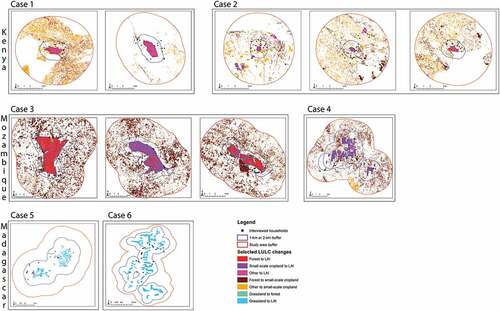
Looking at changes within the LAIs’ perimeters, the studied LAIs in Kenya had mainly converted small-scale cropland and other land (bare soil, grass- and fallow land, bare land, bush- and shrubland, and small waterbodies) into large-scale monocultures, water storage dams, and buildings (, ). Cases 1 and 2 are technologically developed, with fields connected to efficient irrigation networks and some of them even equipped with artificial lighting. Particularly in Case 2, land use conversion on the LAI premises included the construction of large greenhouses and water storage dams. We also observed that the LAI areas in these two heavily industrialized cases are smaller than in the other cases. For Cases 1 and 2, only about one-quarter of the respondents reported a decrease in the size of their cropland, and very few related this to the establishment of an LAI (exclusively in Case 2) (). One respondent in Case 1 said that an LAI had purchased part of the communal grazing land. In Mozambique, in Case 3, the LAI was established partly on small-scale cropland and partly on forested land, while in Case 4, the LAIs mainly converted small-scale cropland. Correspondingly, Case 4 had the highest percentage of respondents attributing a reported decrease in their cropland to the establishment of an LAI. The average size of cropland lost, however, was larger in Case 3, at four hectares, than in Case 4 (two hectares). In Madagascar, the situation was different, as the LAIs had been established almost exclusively on extensive grasslands. In Case 6, all 35 households reporting a decrease in their grazing land said it was because of the LAI, which received large areas of grazing land based on negotiations with the local chief. These households lost access to shared grazing land between 5 and 147 hectares in size. They somewhat adjusted to the decrease in available grazing land by reducing livestock numbers or by taking their livestock to graze on neighbouring communities’ land.
In the 5-km buffers around the LAIs, we specifically examined what type of land had been affected by the expansion of small-scale cropland (). In Kenya, this was mainly land in the category ‘Other’, which mainly includes grassland, fallow land, and bush- and shrubland, representing Kenyan savanna – a mixed woodland-grassland ecosystem; it was thus mostly uncultivated and unmanaged land. Although about half of those respondents in Kenya who reported a change in the size of their own cropland said that it had increased, this was not related to the LAIs in any way. In Mozambique, where remote sensing showed that most of the new cropland had been established at the expense of forest, this was at least partly related to the displacement of small-scale farmers’ cropland by the LAI. In Case 3, where 71% of small-scale farmers who had lost cropland to an LAI had received some financial compensation from that LAI, 65% had acquired new cropland. And even in Case 4, where only 5% reported having received a compensation, 45% had replaced their lost cropland with new cropland. In both cases, the new cropland had been established mainly at the expense of forest. Overall, 28% of all interviewed households in our study (n = 271) had lost land to an LAI.
3.2. Changes in the management of agricultural land
Whether respondents had changed the way they managed their cropland since they had begun to cultivate differed significantly between the cases (). Overall, about 38% of the respondents (n = 266), most of them in Kenya, reported a cropland management change. Most frequently, this involved a change of seed varieties or the entire crop, mechanization for tillage, and a reduction in irrigation. However, some households actually increased their use of irrigation. The main reason given for these changes was lack of water. Whether respondents perceived the LAI to be the cause for the changes they implemented on their cropland, was significantly different between the cases. Of those respondents who reported a change in their cropland management, 37% (n = 38) in Case 2 and 15% (n = 26) in Case 1 related this to the LAIs, mainly because they perceived them to use an excessive amount of river water. In Case 3, in Mozambique, although only 38% of the respondents (n = 45) mentioned a change in their cropland management, 87.5% of these (n = 16) said this was due to the loss of land to the LAIs. The decrease in available land had caused households to abandon certain crops (e.g. rice, sunflowers, soy) that they had grown before. In Case 4, although one-fifth of the respondents (n = 52) reported a change in their cropland management, only few linked it to the LAIs. Most said they had wanted to increase yields and income from the sale of crops. In Case 5, in Madagascar, 24% of the respondents (n = 25) said they had changed the way they managed their cropland; this mainly involved the introduction of new crops (e.g. chilli, tomatoes), use of fertilizers, and irrigation. In one case, the household had abandoned their own crop production after having found employment with the LAI.
Table 4. Reported changes in agricultural land management. Only responses with a total percentage value five or more are presented, and percentage values are given only for samples larger than five
Looking at the management of grazing land, only 11% of all households with livestock (n = 140) reported a change, mostly in Kenya. There, the main changes included increased stall-feeding, the introduction of rotational grazing, the abandonment of livestock breeding, or a change in the breed of cattle. The main reasons given were overgrazing, drought, the desire to increase milk production, and personal reasons. In the other cases, respondents did not report any changes in their grazing land management.
3.3. Tree cover changes
The changes in tree cover perceived by respondents were significantly different between the cases (). Nearly all respondents in Kenya and a majority in Mozambique did notice a change in tree cover. In Madagascar, not a single respondent observed any change, as tree cover is generally very low in Case 5 and even more so in Case 6. The specific types of tree cover changes observed by the respondents differed significantly between cases. Three-quarters of all respondents (n = 271) perceived a decrease in natural or planted tree cover in their surrounding landscapes. In Cases 3 and 4, in Mozambique, the remote-sensing results clearly support these perceptions; in both cases, we found a loss in tree cover of 9.4% between 2000 and 2015 (See Table S2). By contrast, in Case 1, in Kenya, where the majority of the respondents likewise perceived the tree cover to have decreased, remote-sensing results showed a slight increase by 1.5%. Case 2, also in Kenya, is an exception: Here, 55% of the respondents (n = 58) had noticed an increase in planted tree cover. This is supported by the remote-sensing results, which indicate that the tree cover increased by 4.1% between 2000 and 2016 (See Table S2).
Table 5. Perceived changes in tree cover in the landscapes surrounding the LAIs. Percentage values are given only for samples larger than five
The main reasons given for a decrease in tree cover are the expansion of other land uses – mainly cropland, but also settlements – and the exploitation of wood resources for timber, firewood, and charcoal production (). The importance of these reasons differs between Kenya and Mozambique: In Kenya, the exploitation of wood resources is more important than land expansion, whereas it is the other way round in Mozambique. Some of the other reasons mentioned by few respondents were dry spells, tree diseases, less strict enforcement of logging bans, forest fires, water pollution affecting tree growth, and elephant damage (in Kenya), as well as population growth in general (mainly in Mozambique). The only reason given to explain the observed increase in tree cover was that individual land users planted trees for a variety of purposes, including as windbreaks, to create aesthetic value (in Kenya and Mozambique), to provide shade, to increase rainfall, to improve environmental conditions more generally, to expand their supply of wood resources or timber (for sale), and for use in agroforestry (only in Kenya).
A few respondents perceived a direct link between the LAIs and a change in tree cover. This was most pronounced in Case 4, in Mozambique, where five respondents linked the decrease in tree cover to mainly one LAI having cleared trees. In Case 1, in Kenya, one respondent mentioned the same reason. In Case 2, two respondents explained a perceived decrease in natural tree cover with the LAIs’ demand for construction wood, whereas, conversely, one respondent attributed a perceived increase in tree cover to an LAI planting trees as a windbreak. One other respondent mentioned that one of the LAIs had provided tree seedlings to the surrounding households, which had led to more trees being planted.
3.4. Other perceived impacts of LAIs
The majority of the households interviewed (41.1%, n = 270) perceived that the LAIs had exclusively negative impacts on their household, while only 22.6% stated that the LAIs had exclusively positive impacts (). Another 14.1% perceived both positive and negative impacts, and 22.2% did not perceive any impact at all. However, this differed significantly between cases (p < 0.001). In Case 4, in Mozambique, 71.2% of the respondents (n = 52) perceived only negative impacts, whereas in Case 5, in Madagascar, 85% of the respondents (n = 25) perceived exclusively positive impacts.
Figure 3. Perceived impacts of LAIs on (a) households, (b) the environment, (c) people’s health, (d) infrastructure, and (e) conflicts, as well as (f) overall preference of households for LAI companies to stay or leave; all expressed as percentages of households reporting impacts or no impacts (a–e) or a certain preference (f)
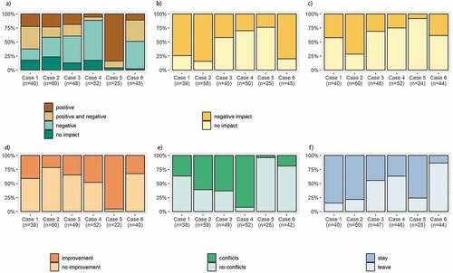
Increased employment opportunities were mentioned most frequently across all cases by respondents reporting exclusively positive impacts (49.2%, n = 61). As employment opportunities are often mentioned as a benefit for local communities in the public discourse on LAIs, we would like to provide some more details regarding this aspect. Whether households had someone employed with the LAI currently, previously, or never before, was significantly different between the cases (Table S3). At the time of the interviews, overall, about 13% of all respondents (n = 270) had at least one member working for the nearby LAI. This was most common in Case 3, in Mozambique, where about 33% of respondents (n = 49) had a household member currently employed by the nearby LAI, whereas in Cases 1, in Kenya, and 6, in Madagascar, this was very rarely the case. Overall, about 28% of households (n = 270) had previously had members employed. In Case 5, in Madagascar, consisting of the jatropha-producing LAI that collapsed shortly before we conducted the interviews, 80% of the households had worked for the LAI (n = 25). However, the majority of all interviewed households had never had members working for any of the LAIs. Respondents mentioned many reasons for this, which differed significantly between the cases, the most important one being that it was difficult to find a job. This indicates that there is an unfulfilled demand for employment opportunities with LAIs, especially in Cases 4, in Mozambique, and 6, in Madagascar. In Kenya, the majority of respondents were already employed elsewhere, ran small private businesses, preferred to work on their own farms, or were generally not interested in working for an LAI. Perceived bad working conditions were an important reason why respondents did not want to work for an LAI in Case 3, in Mozambique.
After employment, improved security in the area was the second most frequently mentioned positive impact reported (8.2%, n = 61) (), although it was mentioned only in Cases 1 and 2, in Kenya. The impact mentioned most frequently by respondents who reported exclusively negative impacts was loss of land to the LAI (28.8%, n = 111); this was mentioned in Cases 3 and 4, in Mozambique. Other frequently mentioned negative impacts included air pollution from chemicals (9.9%), mainly in Cases 1 and 2, in Kenya; blocked footpaths (9.9%) in Cases 3 and 4, in Mozambique; and general disregard of local communities’ needs (9.9%), mainly in Case 6, in Madagascar.
In terms of adverse environmental impacts, 58.8% of the respondents (n = 262) did perceive the nearby LAI to have affected the environment (). Case 2, in Kenya, had the highest percentage of respondents perceiving environmental impacts of the LAI (84.5%, n = 58), and Case 5 in Madagascar the lowest (24%, n = 25). The most commonly reported environmental impact was air pollution (38.3%, n = 154), mentioned mainly in Cases 1, 2, and 6. This was followed by reduced availability of river water (20.1%) in the same cases, and water pollution from chemicals (14.3%) mainly in Case 6. Respondents attributed the reduced availability of river water to the LAI’s use of river water to irrigate its crops; to mechanized ploughing, which brought more sediments into the streams; and to the in-migration of LAI workers, which led to an overuse of groundwater wells. One respondent in Case 6 stated that he believed the LAI had stopped the rain on purpose because they did not need a lot of rain for their maize plantations; lack of rain mainly affected the drinking water supply for the zebu cattle. Water pollution, in Case 6, was attributed to pesticides that the LAI used on its maize plantations; the runoff from the fields carried the chemicals into the river, polluting the water that the respondents used for cooking. One respondent went as far as to suggest that the LAI purposely polluted local people in order to be able to occupy their land.
Negative health impacts from the LAIs were reported by 39.9% (n = 268) of the respondents, with the highest percentage occurring in Case 2, in Kenya (71.7%, n = 60), and the lowest in Case 5, in Madagascar (8.3%, n = 24). Frequently mentioned impacts were respiratory problems, reported by 40.2% (n = 107), mainly in Cases 1, 2, and 6, as well as cold and diarrhoea, reported by 13.1%, mainly in Case 6; and exposure to chemicals, mentioned by 11.2%. Infrastructure was reported to have been built by the nearby LAI by to 40.1% of the respondents (n = 262), with the highest percentage occurring in Case 5 (95.5%, n = 22) and the lowest in Case 2 (21.7%, n = 60). Of the respondents who reported a contribution to infrastructure by the LAI (n = 84), 47.6% mentioned school buildings (in all cases) and 31% a well (in Cases 5 and 6, in Madagascar). Conflicts between the LAI and the surrounding communities were reported by the majority of the respondents (52.1%, n = 265). This was most pronounced in Case 4, in Mozambique, with 92.3% (n = 52) of respondents reporting a conflict, and least pronounced in Case 5, in Madagascar (4%, n = 25). The main sources of conflict mentioned were water use (28.4%, n = 74), mainly in Case 1 and 2, and water pollution (16.2%), in Case 2. In Case 4, which had the highest percentage of respondents reporting conflicts, only few respondents specified the reasons. Apart from loss of access to land, these included some land users being jealous of others who had found employment with an LAI, and the mistreatment of workers.
Despite the various negative impacts of LAIs reported, the majority of the respondents (55%, n = 262) stated that they preferred the nearby LAI to remain operational. However, this again differed widely between cases. In the two Kenyan cases, as well as in the Malagasy Case 5, the majority of respondents wished for the LAI to stay. (In Case 5, respondents regretted that the LAI had stopped operating). In contrast, the majority of respondents wished for the LAI to leave in the two Mozambican cases and, most strongly so, in the Malagasy Case 6.
4. Discussion
Our results highlight a range of impacts of LAIs on surrounding farmers’ use and management of land, tree cover, as well as on other aspects relevant for sustainable development in Kenya, Mozambique, and Madagascar.
Regarding the LAIs’ contribution to land use change, we found that the LAIs were mostly established on small-scale farmers’ cropland or grassland. Only in one case in Mozambique did the LAIs clear forest to make room for commercial crop plantations. This finding is in contrast to those of other studies which showed that LAIs acted as powerful drivers of deforestation (Davis et al. Citation2015; Curtis et al. Citation2018; Magliocca et al. Citation2020). Nevertheless, the Mozambican case shows that the assumption that LAIs mainly target degraded land to improve its production value does not hold. Moreover, the remote-sensing-based analysis showed that in the landscapes surrounding the LAIs in Mozambique, the main LULC change was from forest to small-scale cropland. Combining this finding with information from land users, we can confirm that at least part of this deforestation was indirectly linked to the establishment of LAIs. In the Mozambican context, where forested land was still available, part of the land users who lost land to an LAI would mainly make up for this loss by clearing new land for crop production. This empirical evidence supports the land science theories of indirect land use change and activity leakage (Meyfroidt et al. Citation2018). While we did not find any sign of displaced homes in our study, we provide evidence that in the Mozambican Nacala Corridor, local land users’ cropland was displaced through the establishment of LAIs, at the detriment of natural forest. In Madagascar, the LAI in Case 6 had a direct impact on local land users’ pastures, part of which were lost due to their conversion for mechanized maize production. Whether intentionally or not, governmental stakeholders often consider grassland and pastures to be idle and underused land and therefore offer them to investors for the development of commercial agriculture (Li Citation2014; Messerli et al. Citation2014; Schoneveld and German Citation2014). Our case in Madagascar shows that these are highly contested decisions, as out of the six cases studied this was the one that received the least support from local land users.
In Kenya, where land users were not dispossessed of their land, we found that the LAIs had an indirect impact on land management rather than land use. Some respondents had switched to crop varieties requiring less water or had reduced the irrigation of their crops, because they had perceived a decrease in river water availability – which they attributed to LAIs’ excessive use of water for irrigation. A few others abandoned potato farming due to perceived water pollution from an LAI upstream that released wastewater into the river. We would like to note that this evidence is anecdotal and it is unclear how many land users in the area did take such action due to perceived environmental impacts from LAIs. Nevertheless, this confirms that water use and management is a highly contested issue between LAIs and small-scale farmers in the Laikipia region (Ulrich Citation2014; Ngutu et al. Citation2018). As so far no quantitative measurements are available to clarify who uses how much water at what time of the year or who pollutes water through what sources it remains a disputed issue. While small-scale farmers have organized into Water Resource Users Associations that regulate access to and use of water (Kiteme and Gikonyo Citation2002), LAIs have invested in rainwater harvesting measures and large storage ponds (Ngutu et al. Citation2018). Nevertheless, it is clear that the establishment of LAIs for flower and vegetable production has added pressure to the already tense situation around water quantity and quality. Indirect impacts on land management were observed in Mozambique as well: Respondents who had lost land to an LAI explained that this not only led them to search for new cropland, but that they also abandoned certain crops because they no longer had sufficient land. While a growing number of studies show causal links between LAIs and off-site land use change in Africa, South America, and Asia (Arima et al. Citation2011; Andrade De Sá et al. Citation2013; Boamah and Overå Citation2016; Magliocca et al. Citation2019), our study is among the first to show that the establishment of LAIs also has indirect impacts on how farmers in its surroundings manage their land.
The widespread tree cover changes observed in the landscapes surrounding the LAIs were only infrequently perceived to be linked to the LAIs’ establishment. It was mainly in Mozambique where some respondents attributed a decrease in tree cover to an LAI clearing trees. In Kenya, where respondents reported an increase in tree cover, a small number of them thought that this was thanks to the LAIs planting trees or providing seedlings. Other processes happening in these landscapes, such as the expansion of cropland and settlements by small-scale farmers and the exploitation of wood resources for timber, firewood, and charcoal are more important drivers of tree cover loss. In Kenya, respondents further observed that people planted trees on their fields out of their own will, for a number of environmental, sociocultural, and economic purposes. Unravelling the LAIs’ role in directly affecting tree cover (e.g. felling trees for timber or planting trees as windbreaks) in the wider landscape would merit more in-depth research, as so far there is only limited evidence for such actions provided by our interviews.
We also looked at the wider perceived impacts of LAIs on households, of which increased employment opportunities was the one most often mentioned as a positive one. Nevertheless, overall, only few of our respondents were employed by the nearby LAI at the time of the interviews. This corresponds to findings from other empirical studies showing that employment benefits from LAIs in Africa occurred only to few local people (Byerlee and Deininger Citation2013; Hakizimana et al. Citation2017; Palliere and Cochet Citation2018). Only in one of our six cases – the LAI planting jatropha in Madagascar – did a majority of the respondents work for the company. However, this project collapsed after only a few years, leaving the workers to return to subsistence farming and livestock keeping. This, and the fact that a higher percentage of respondents had worked for an LAI previously than at the time of the interviews, highlights the insecure and temporary nature of most employment opportunities provided by the LAIs in our study. However, it is also important to consider that some people prefer not to be employed by an LAI. In Kenya, land users find other opportunities to earn additional income or prefer to work on their own farms. In Mozambique, the perceived bad working conditions deterred land users from seeking employment with LAIs. Only in Madagascar did the majority of those not employed by the nearby LAI regret this fact. Our study suggests that the questions of what land users wish for in terms of employment, and whether the potential benefits from employment in commercial agriculture would outweigh other impacts on well-being and people’s values, should be put at the centre of the scholarly discussion around the employment impacts of LAIs.
Small-scale farmers’ general perceptions of LAIs established in their rural landscapes mostly vary between cases, and less so between countries. It seems that the type of LAI and its business and production model (Giger et al. Citation2020) is therefore more decisive with regard to its impacts on the ground, than the surrounding social-ecological context. Only in two of the six cases did our respondents perceive the LAIs’ impacts to be predominantly positive or at least mixed. This was the case for the vegetable-producing LAIs in Kenya and the abandoned jatropha LAI in Madagascar. In these cases, the employment opportunities and benefits from infrastructure establishment seemed to outweigh the disadvantages in terms of environmental or health issues. Negative perceptions of LAIs were fuelled mainly by the issues of land loss to LAIs and environmental impacts in terms of air and water pollution, as well as a wide range of other perceived environmental and health impacts. Our results therefore support the available scientific evidence regarding LAIs’ impacts on surrounding land users in low-income countries, which paints a rather bleak picture (e.g. Li Citation2011; Oberlack et al. Citation2016; Hufe and Heuermann Citation2017). Far from the initial promises of providing a win–win situation that promotes national economic development and rural poverty alleviation, such large-scale commercial investments in land provide at best some employment and infrastructural benefits to few. More importantly, however, they cause harm to many in the form of land dispossession, environmental impacts, and impacts on human health. This is unacceptable in the context of the Agenda 2030’s sustainable development goals (United Nations Citation2015) and raises severe concerns about environmental justice (Schlosberg Citation2004; Hall et al. Citation2015). We therefore urgently need to direct future research efforts towards options to support the transformation to more sustainable development in such contested situations of large-scale land acquisition. This will require carefully facilitated negotiations among the different stakeholders involved, from the government agencies issuing concessions to the companies implementing LAIs and the land users who largely bear the costs of these investments.
5. Conclusion
Our empirical study, drawing on small-scale farmers’ perceptions and analysis of remotely sensed land use and land cover data, provides novel insights into the broad impacts that LAIs in Kenya, Mozambique, and Madagascar have on land use and the environment. This is one of the first studies to comprehensively assess both direct and indirect impacts of LAIs on land use and land management. We found that LAIs contributed directly as well as indirectly to deforestation in Mozambique, triggered changes in small-scale farmers’ land management due to water shortage and pollution in Kenya, and caused pastoralists to lose access to grazing land in Madagascar. Despite some benefits from employment opportunities and infrastructure improvement, the majority of small-scale farmers interviewed perceived their nearby LAI’s overall impacts as negative, highlighting reduced access to land and water, pollution, health issues, and unsatisfactory working conditions. However, just slightly more than half of the respondents stated that they would prefer their nearby LAI to remain operational. This seems to be more the case in countries where a clear regulatory framework for land acquisitions exists and is implemented, and where land tenure rights are clearly formalized and registered. Further, it seems to apply to LAIs who make an effort to avoid environmental impacts, care for the social and economic well-being of people in their surroundings, and contribute to the region’s wider economic development. Overall, there is ample space for negotiations among the different actors to improve LAIs’ contribution to sustainable development. Future research should look into concrete options for supporting such a transformation, which needs to take into account small-scale farmers’ needs and visions, as those are the actors mostly depending on the land for their livelihoods. This would correspond to increasing concerns for social and environmental justice of global consumers’ impacts in distant places, and reduce the risk of harm and conflicts in LAI host countries.
Author contributions
Julie G. Zaehringer and Sandra Eckert: Conceptualization, Methodology, Software, Formal analysis, Investigation, Data Curation, Writing - Original Draft, Writing - Review & Editing, Visualization, Supervision. Peter Messerli: Writing - Review & Editing, Funding acquisition. Markus Giger and Boniface Kiteme: Writing - Review & Editing. Ali Atumane, Maya da Silva, and Lovasoa Rakotoasimbola: Investigation, Writing - Review & Editing.
Disclosure of potential conflicts of interest
No potential conflict of interest was reported by the author(s).
Supplementary Materials
Download PDF (899 KB)Acknowledgments
This study contributes to the Global Land Programme https://glp.earth. We are very grateful to the 271 respondents who took the time to answer our questions, to our project partners in Kenya, Mozambique, and Madagascar who supported logistics, and to the enumerators who conducted the interviews in the three countries. We also thank Marlène Thibault for copyediting our manuscript. The research for this publication was conducted as part of the BELMONT Forum and FACCE–JPI project “African Food, Agriculture, Land and Natural Resource Dynamics, in the context of global agro-food-energy system changes (AFGROLAND)” (Grant Number: 40FA40_160405). The project is funded by the Swiss National Science Foundation, the French National Research Agency, and the South African National Research Foundation. Elements of this work were undertaken whilst Julie G. Zaehringer was a visiting scholar at the Department of Geography, University of Cambridge (May 2018–April 2019), supported through Scientific Exchange funding from the Swiss National Science Foundation (SNSF), under Grant No. IZSEZ0_180391. We thank the editors for their constructive review.
Supplemental Material
Supplemental data for this article can be accessed here.
Additional information
Funding
Related Research Data
References
- Andrade De Sá S, Palmer C, Di Falco S. 2013. Dynamics of indirect land-use change: empirical evidence from Brazil. J Environ Econ Manag. 65:377–393. doi:10.1016/j.jeem.2013.01.001
- Anseeuw W, Boche M, Breu T, Giger M, Lay J, Messerli P, Nolte K, 2012. Transnational land deals for agriculture in the global south: analytical report based on the land matrix database, geographica Bernensia. ed. CDE/CIRAD/GIGA, Bern/Montpellier/Hamburg.
- Arima EY, Richards P, Walker R, Caldas MM. 2011. Statistical confirmation of indirect land use change in the Brazilian Amazon. Environ Res Lett. 6. doi:10.1088/1748-9326/6/2/024010.
- Boamah F, Overå R. 2016. Rethinking livelihood impacts of biofuel land deals in Ghana. Dev Change. 47:98–129. doi:10.1111/dech.12213
- Bottazzi P, Crespo D, Bangura LO, Rist S. 2018. Evaluating the livelihood impacts of a large-scale agricultural investment: lessons from the case of a biofuel production company in northern Sierra Leone. Land Use Policy. 73:128–137. doi:10.1016/j.landusepol.2017.12.016
- Breu T, Bader C, Messerli P, Heinimann A, Rist S, Eckert S. 2016. Large-scale land acquisition and its effects on the water balance in investor and host countries. Plos One. 11:e0150901. doi:10.1371/journal.pone.0150901
- Byerlee D, Deininger K. 2013. The rise of large farms in land-abundant countries: do they have a future? In: Holden ST, Otsuka K, Deininger K, editors. Land tenure reform in Asia and Africa: assessing impacts on poverty and natural resource management. UK (London): Palgrave Macmillan; p. 333–353. doi:10.1057/9781137343819_14
- Carlson AK, Zaehringer JG, Garrett RD, Silva FB, Furumo R, Raya Rey PR, Torres AN, Gon Chung A, Li M, Liu Y. 2018. Toward rigorous telecoupling causal attribution: a systematic review and typology. Sustainability. 10:4426. doi:10.3390/su10124426
- Collier P, Dercon S. 2014. African agriculture in 50 years: smallholders in a rapidly changing world? World Dev, 63:92–101. Economic Transformation in Africa. doi:10.1016/j.worlddev.2013.10.001.
- Congalton RG, Green K. 2008. Assessing the accuracy of remotely sensed data: principles and practices. Boca Raton (USA): CRC press.
- Cotula L. 2012. The international political economy of the global land rush: a critical appraisal of trends, scale, geography and drivers. J Peasant Stud. 39:649–680. doi:10.1080/03066150.2012.674940
- Curtis PG, Slay CM, Harris NL, Tyukavina A, Hansen MC. 2018. Classifying drivers of global forest loss. Science. 361:1108–1111. doi:10.1126/science.aau3445
- Davis KF, Yu K, Rulli MC, Pichdara L, D’Odorico P. 2015. Accelerated deforestation driven by large-scale land acquisitions in Cambodia. Nat Geosci. 8:772–775. doi:10.1038/ngeo2540
- Deininger K, Xia F. 2016. Quantifying spillover effects from large land-based investment: the Case of Mozambique. World Dev. 87:227–241. doi:10.1016/j.worlddev.2016.06.016
- Di Matteo F, Otsuki K, Schoneveld GC. 2016. Soya bean expansion in Mozambique: exploring the inclusiveness and viability of soya business models as an alternative to the land grab. Public Sphere. 61–86.
- Eckert S, Kiteme B, Njuguna E, Zaehringer JG. 2017. Agricultural expansion and intensification in the foothills of Mount Kenya: a landscape perspective. Remote Sens. 9:784. doi:10.3390/rs9080784
- Field A, Miles J, Field Z. 2012. Discovering statistics using R. Los Angeles: Sage publications.
- German L, Schoneveld GC, Pacheco P. 2011. The social and environmental impacts of biofuel feedstock cultivation: evidence from multi-site research in the forest frontier. Ecol Soc. 16:24. doi:10.5751/ES-04309-160324
- Gibbs HK, Ruesch AS, Achard F, Clayton MK, Holmgren P, Ramankutty N, Foley JA. 2010. Tropical forests were the primary sources of new agricultural land in the 1980s and 1990s. Proc Natl Acad Sci. 107. doi:10.1073/pnas.0910275107.
- Giger M, Mutea E, Kiteme B, Eckert S, Anseeuw W, Zaehringer JG. 2020. Large agricultural investments in Kenya’s Nanyuki Area: inventory and analysis of business models. Land Use Policy. 99:104833. doi:10.1016/j.landusepol.2020.104833
- Google Earth Pro, 2017. Google Earth Pro 7.1.2.2041. Coordinates: −16.02853°S/46.77719°E and −22.32011°S/45.70781°E. Viewed April 2016 - December 2016. 2018 Google, US Dept of State Geographer, Image archive for 1987-2018.
- Griffiths P, Kuemmerle T, Baumann M, Radeloff VC, Abrudan IV, Lieskovsky J, Munteanu C, Ostapowicz K, Hostert P. 2014. Forest disturbances, forest recovery, and changes in forest types across the Carpathian ecoregion from 1985 to 2010 based on Landsat image composites. Remote Sens Environ, 151:72–88. Special Issue on 2012 ForestSAT. doi:10.1016/j.rse.2013.04.022.
- Griffiths P, Müller D, Kuemmerle T, Hostert P. 2013. Agricultural land change in the Carpathian ecoregion after the breakdown of socialism and expansion of the European Union. Environ Res Lett. 8:1–12. doi:10.1088/1748-9326/8/4/045024
- Hakizimana C, Goldsmith P, Nunow AA, Roba AW, Biashara JK. 2017. Land and agricultural commercialisation in Meru County, Kenya: evidence from three models. J Peasant Stud. 44:555–573. doi:10.1080/03066150.2016.1260555
- Hall R, Edelman M Jr, Scoones SMB, White I, Wolford B. 2015. Resistance, acquiescence or incorporation? An introduction to land grabbing and political reactions ‘from below. J Peasant Stud. 42:467–488. doi:10.1080/03066150.2015.1036746
- Hufe P, Heuermann DF. 2017. The local impacts of large-scale land acquisitions: a review of case study evidence from Sub-Saharan Africa. J Contemp Afr Stud. 35:168–189. doi:10.1080/02589001.2017.1307505
- Joala R, Zamchiya N, Musole C, Katebe P. 2016. Changing agro-food systems. The impact of big agro-investors on food rights. Case studies in Mozambique and Zambia. Cape Town: PLAAS.
- Kiteme BP, Gikonyo J. 2002. Preventing and resolving water use conflicts in the Mount Kenya highland–lowland system through water users’ associations. Mt Res Dev. 22:332–337. doi:10.1659/0276-4741(2002)022[0332:PARWUC]2.0.CO;2
- Li TM. 2011. Centering labor in the land grab debate. J Peasant Stud. 38:281–298. doi:10.1080/03066150.2011.559009
- Li TM. 2014. What is land? Assembling a resource for global investment. Trans Inst Br Geogr. 39:589–602. doi:10.1111/tran.12065
- Magliocca N, Khuc Q, Ellicott E, De Bremond A. 2019. Archetypical pathways of direct and indirect land-use change caused by Cambodia’s economic land concessions. Ecol Soc. 24. doi:10.5751/ES-10954-240225.
- Magliocca NR, Khuc QV, Bremond A, De, Ellicott EA. 2020. Direct and indirect land-use change caused by large-scale land acquisitions in Cambodia. Environ Res Lett. 15:024010. doi:10.1088/1748-9326/ab6397
- Margulis ME, McKeon N Jr. 2013. Land grabbing and global governance: critical perspectives. Globalizations. 10:1–23. doi:10.1080/14747731.2013.764151
- McHugh ML. 2012. Interrater reliability: the kappa statistic. Biochem Medica. 22:276–282.
- Messerli P, Giger M, Dwyer MB, Breu T, Eckert S. 2014. The geography of large-scale land acquisitions: analysing socio-ecological patterns of target contexts in the global South. Appl Geogr. 53:449–459. doi:10.1016/j.apgeog.2014.07.005
- Meyfroidt P, Roy Chowdhury R, De Bremond A, Ellis EC, Erb K-H, Filatova T, Garrett RD, Grove JM, Heinimann A, Kuemmerle T, et al. 2018. Middle-range theories of land system change. Glob Environ Change. 53:52–67. doi:10.1016/j.gloenvcha.2018.08.006
- Muriithi FK, Yu D. 2015. Understanding the impact of intensive horticulture land-use practices on surface water quality in Central Kenya. Environments. 2:521–545. doi:10.3390/environments2040521
- Ngutu M, Bukachi S, Olungah C, Kiteme B, Kaeser F, Haller T, Ngutu M, Bukachi S, Olungah CO, Kiteme B, et al. 2018. The actors, rules and regulations linked to export horticulture production and access to land and water as common pool resources in Laikipia County, Northwest Mount Kenya. Land. 7:110. doi:10.3390/land7030110
- Nolte K, Chamberlain W, Giger M, 2016. International land deals for agriculture. fresh insights from the land matrix: analytical report II. Centre for Development and Environment; Centre de coopération internationale en recherche agronomique pour le développement; German Institute of Global and Area Studies; University of Pretoria; Bern Open Publishing, Bern/Montpellier/Hamburg/Pretoria.
- Oberlack C, Tejada L, Messerli P, Rist S, Giger M. 2016. Sustainable livelihoods in the global land rush? Archetypes of livelihood vulnerability and sustainability potentials. Glob Environ Change. 41:153–171. doi:10.1016/j.gloenvcha.2016.10.001
- Oldeman LR, 1990. Agroclimatic characterization of Madagascar., Technical Paper. ISRIC, Wageningen (The Netherlands).
- Palliere A, Cochet H. 2018. Large private agricultural projects and job creation: from discourse to reality. case study in Sella Limba, Sierra Leone. Land Use Policy. 76:422–431. doi:10.1016/j.landusepol.2018.02.017
- R Core Team. 2015. R: a language and environment for statistical computing. Vienna (Austria):R Foundation for Statistical Computing.
- Rudel TK, DeFries R, Asner GP, Laurance WF. 2009. Changing drivers of deforestation and new opportunities for conservation. Conserv Biol. 23:1396–1405. doi:10.1111/j.1523-1739.2009.01332.x
- Rulli MC, Saviori A, D’Odorico P. 2013. Global land and water grabbing. Proc Natl Acad Sci. 110:892–897. doi:10.1073/pnas.1213163110
- Schlosberg D. 2004. Reconceiving environmental justice: global movements and political theories. Environ Polit. 13:517–540. doi:10.1080/0964401042000229025
- Schoneveld GC. 2017. Host country governance and the African land rush: 7 reasons why large-scale farmland investments fail to contribute to sustainable development. Geoforum. 83:119–132. doi:10.1016/j.geoforum.2016.12.007
- Schoneveld GC, German L. 2014. Translating legal rights into tenure security: lessons from the new commercial pressures on land in Ghana. J Dev Stud. 50:187–203. doi:10.1080/00220388.2013.858129
- Schoneveld GC, German L, Nutakor E. 2011. Land-based investments for rural development? A grounded analysis of the local impacts of biofuel feedstock plantations in Ghana. Ecol Soc. 16. doi:10.5751/ES-04424-160410.
- Smaller C, Speller W, Mirza H, Bernasconi-Osterwalder N, Dixie G, 2015. Investment contracts for agriculture: maximizing gains and minimizing risks., agriculture global practice discussion paper 3. World Bank Group, United Nations, International Institute for Sustainable Development, Washington D.C., New York, Winnepeg.
- Soafilira A, Abdourabi KF, Randrianandrasana NN, Razafintsalama N, Randriamisata P, Rakotoarivelo M, Rakotoson NJ, Nomebarijaona R, 2015. Analyse Socio-Economique de l’Impact des Activités de la Sociéte Fuelstock Madagascar. Solidarité des Inervenants sur le Foncier (SIF et le Centre Social Arrupe (CSA), Antananarivo, Madagascar.
- Ulrich A. 2014. Export-oriented horticultural production in Laikipia, Kenya: assessing the implications for rural livelihoods. Sustainability. 6:336–347. doi:10.1016/j.jrurstud.2012.02.003
- Ulrich A, Ifejika Speranza C, Roden P, Kiteme B, Wiesmann U, Nüsser M. 2012. Small-scale farming in semi-arid areas: livelihood dynamics between 1997 and 2010 in Laikipia, Kenya. J Rural Stud. 28:241–251. doi:10.1016/j.jrurstud.2012.02.003
- UNEP/GRID, 2017. Kenya – AgroClimatic Zones. ICPAC-IGAD-UNOSAT GeoPortal.
- United Nations, 2015. Transforming our world: the 2030 agenda for sustainable development. A/RES/70/1. United Nations (New York, NY). doi:10.1891/9780826190123.ap02
- Wiesmann UM, 2008. Peasant strategies and ecological adaptation in semi-arid laikipia district, Kenya. (revised version of Wiesmann U., 1998. Geographica Bernensia, African Studies No. 14. Bern), in: Sustainable Regional Development in Rural Africa: Conceptual Framework and Case Studies from Kenya, NCCR North-South Internet Publications.
- The World Bank. 2006. Mozambique agricultural development strategy. Stimulating smallholder agricultural growth. (No. 32416- MZ). Maputo (Mozambique):The World Bank.
- The World Bank. 2011. Rising global interest in farmland. Washington D.C:The World Bank.
- The World Bank, 2014. The practice of responsible investment principles in larger-scale agricultural investments. Implications for corporate performance and impact on local communities. (No. 86175- GLB), Agriculture and Environmental Services Discussion Paper 08. The International Bank for Reconstruction and Development/The World Bank, Washington D.C.
- Zaehringer JG, Atumane A, Berger S, Eckert S. 2018a. Large-scale agricultural investments trigger direct and indirect land use change: new evidence from the Nacala corridor, Mozambique. J Land Use Sci. 13:325–343. doi:10.1080/1747423X.2018.1519605
- Zaehringer JG, Wambugu G, Kiteme B, Eckert S. 2018b. How do large-scale agricultural investments affect land use and the environment on the western slopes of Mount Kenya? Empirical evidence based on small-scale farmers’ perceptions and remote sensing. J Environ Manage. 213:79–89. doi:10.1016/j.jenvman.2018.02.019