
ABSTRACT
There is a disconnect between the urgency of responding to the threats posed by climate change and the existing resources, technical capacity, and political will necessary to engage in resilience planning and climate action. A variety of frameworks for bridging these gaps exist, but few have emerged through an iterative process of piloting and refining strategies to bridge these gaps on the ground. The Resilience Adaptation Feasibility Tool (RAFT) framework builds upon decades of experience designing and implementing community engagement processes and offers an alternate model for advancing resilience and climate adaptation planning that leverages social learning to build consensus around shared values and community priorities. This paper documents the RAFT process, situates it within the context of climate adaptation planning research, and articulates its specific strengths as a flexible and portable model for engaging the public in preparing for climate change impacts.
Introduction
Planning for climate resilience is a relatively recent phenomenon in the United States (Lambrou & Loukaitou-Sideris, Citation2022; S. C. Woodruff et al., Citation2022). While local governments have been leaders in responding to the threats posed by climate change (Nordgren et al., Citation2016), there is a growing consensus that they need clearer guidance for implementing the strategies and principles articulated in climate adaptation plans (Hughes, Citation2015; S. C. Woodruff & Stults, Citation2016). There is a disconnect between the urgency of responding to the threats posed by climate change and the existing resources, technical capacity, and political will necessary to engage in resilience planning and climate action. Virginia is one of the nine states that “do not directly delegate police power to local governments” leaning more heavily on what has become known as Dillon’s Rule, which suggests that only those powers expressly granted by the state may be exercised (National League of Cities, Citation2020). It has been argued that this interpretation of the authorities of local governments with respect to state legislatures limits the ability of local governments to experiment and innovate in a variety of policy areas (Parlow, Citation2007). A variety of frameworks for bridging these gaps exist, but few have emerged through an iterative process of piloting and refining strategies to bridge these gaps on the ground. In contrast, the Resilience Adaptation Feasibility Tool (RAFT) framework builds upon decades of experience designing and implementing community engagement processes, and offers an alternate model for advancing resilience and climate adaptation planning that leverages social learning to build consensus around shared values and community priorities. This paper documents the RAFT process, situates it within the context of climate adaptation planning research, and articulates its specific strengths as a flexible and portable model for engaging the full community – and as broad a spectrum of the public as possible – in preparing for climate change impacts. Finally, areas of commonality and important contrasts between the RAFT and other frameworks that are currently used to guide resilience planning efforts are highlighted and discussed.
Defining and assessing coastal resilience
The threats posed by climate are especially serious and immediate in coastal areas. As the planet warms, sea level is expected to rise inundating important ecosystems (e.g. salt marshes and estuaries), displacing entire neighborhoods and perhaps whole cities, compromising critical infrastructure, and forcing a renegotiation of society’s relationship with the ocean. Sea level rise is largely driven by melting ice from glaciers and polar ice sheets as well as thermal expansion, which is the physical process by which water molecules literally expand when heated. Sea level rise exacerbates tidal flooding (Dahl et al., Citation2017) – which is often described as “nuisance flooding” due to its regular occurrence but has less significant effects – and can also negatively affect both groundwater supply and septic systems in more rural areas. Climate change is also expected to contribute to more frequent and more intense storms (e.g. hurricanes) and a hypothetical Category 1 hurricane that makes landfall in Virginia is estimated to place at least 23,232 single-family homes at risk with an estimated reconstruction cost of over $5.9 billion (Insurance Information Institute, Citation2022). The initial phase document of the Virginia Coastal Resilience Master Plan (VCRMP) was released in December 2021 and defines resilience as “the capability to anticipate, prepare for, respond to, and recover from hazards to minimize damage to social well-being, health, the economy, and the environment,” a definition adopted from the US. Global Change Research Program (Commonwealth of Virginia - Office of the Governor, Citation2021) and one of the goals outlined in this statewide planning framework is that every locality – defined by the legislature as a county, city, or town – in the coastal regions of Virginia will participate in the RAFT process (p. 69).
Community engagement in resilience planning
Although public participation and community engagement more broadly are cornerstones of effective and ethical community planning practice, prior research has shown that these aspects are often neglected or under-developed (Boswell et al., Citation2019). In some cases, engagement efforts are perfunctory and may be viewed by all involved as an “empty ritual” rather than as a mechanism for better understanding the experiences and priorities of the public. Meaningful participation by the public in planning and decision-making lends legitimacy to the outcomes of these processes and may help to make implementation more likely (Arnstein, Citation1969). A recent evaluation of resilience policies enacted in the 101 largest cities in the United States found that “outreach and engagement policies such as public participation and collaboration are the least common” and roughly one-third of the sample had no outreach or engagement policies at all (S. Woodruff et al., Citation2021).
Introducing the RAFT
The RAFT framework emerged from a partnership between three academic institutions – the Institute for Engagement & Negotiation (IEN) at the University of Virginia, the Virginia Coastal Policy Center at William & Mary Law School, and the Virginia Sea Grant Climate Adaptation and Resilience Program based at Old Dominion University – that began in 2015. The RAFT partners developed the framework with the assistance of an advisory committee and launched a pilot project to test it in three Virginia coastal localities in 2017 (Andrews et al., Citation2021).
The RAFT as a planning framework
Although primary responsibility for implementing the RAFT process resides with a project team comprised of representatives of the three academic institutions engaged in the partnership in consultation with governmental actors at either the regional or local scale, a distinguishing characteristic is its commitment to local development of resilience priorities and providing technical support to a wide range of stakeholders for implementation of their resilience priorities. Emphasizing collaboration and a community-driven approach to resilience, the RAFT offers a model for bridging some of the most widespread gaps in resilience planning in the United States that has been refined and proven through several applications since 2015. The RAFT has been designed in such a way that it can be used in a variety of places, from sparsely populated rural communities to cities with hundreds of thousands of residents. One of the aims of this paper is to outline a strategy for extending the RAFT so that it can be applied within inland communities that face threats from climate change impacts but that are not subject to coastal hazards like sea level rise, while leveraging the framework’s community engagement and empowerment strengths.
Goals of the RAFT
The RAFT was developed in response to two challenges that limit efforts to address climate impacts in coastal Virginia and beyond. The first of these is that politicians tend to be myopic in that it is difficult and unusual for them to look beyond election cycles and their own time in office. It takes strong political will to confront tomorrow’s threats with today’s tax revenue. The second motivation was to synthesize the array of data and research related to coastal resilience in a way that is better aligned with existing planning and decision-making processes. Stated differently, “elected officials could not connect longitudinal studies and models with simple steps that could be taken during their short-term planning horizons while in office” (Andrews et al., Citation2021, p. 25). Since its inception, the RAFT has continuously evolved to incorporate lessons learned from previous implementations and to better respond to the demands of resilience planning in the diverse local contexts of Virginia because not only are the relevant climate impacts different along the coast versus inland areas, patterns of social vulnerability also vary across the rural–urban continuum (Yusuf et al., Citation2022).
The RAFT process
The RAFT process consists of three phases spread over an 18-month period. Before initiating the process, the RAFT Team partners with the relevant regional planning district commission to obtain their support for conducting the RAFT in their region, as well as their recommendations for any customization of the RAFT process to accommodate the specific needs and context of the region. An important aspect of these discussions involves the identification of localities (i.e. cities, towns, and counties) within the region that should be considered candidates to participate in the RAFT process. Although the specific criteria for participation necessarily vary, at a minimum there must be one or more climate change impacts to be addressed and a willingness on the part of local government and community-based organizations to work on these issues with the RAFT Team and regional planning organization staff. After that, as shown in , Phase 1 involves compiling, reviewing, and assessing relevant planning documents, ordinances, programs, and reports to characterize the existing state of coastal resilience within the participating localities, and summarizing those findings in what is called a RAFT Scorecard. The assessment is verified by the appropriate staff of each participating locality, and members of the RAFT Team present the Scorecard results to the elected officials of each locality.
Figure 1. Overview of the RAFT process.

Simultaneous with the quantitative assessment conducted through the scoring process, the RAFT Team conducts a qualitative assessment of each participating locality by conducting interviews and listening sessions with community service providers. The goal is to understand how community leaders view challenges, strengths, and opportunities for building resilience. The information gathered from that effort is incorporated into the next phase of the process, which involves holding a regional workshop with elected officials, local government staff, residents, businesses, community-based organizations, and other stakeholders from all of the participating localities in that region to (1) present the Scorecard findings for all of the localities, enabling both a regional and a local overview of resilience efforts; (2) discuss and prioritize ways to enhance resilience, including a list of opportunities compiled by the RAFT Team from the locality Scorecards, qualitative assessments, Hazard Mitigation Plans, and other sources; and (3) create a Resilience Action Checklist (RAC) of interventions to be pursued over the coming year in each locality. During this workshop, members of the RAFT Team facilitate the collaborative development of the RAC by break-out groups for each locality and help ensure that the RAC contains items that are both meaningful from a resilience perspective yet feasible given the existing planning and regulatory environment, fiscal conditions, etc. A key task for participants in the Phase 2 workshop is to prioritize items on the RAC and to identify three to five items to immediately pursue over the subsequent year. The final phase of the RAFT process involves implementing the RAC with regularly scheduled meetings of local leaders called and facilitated by members of the RAFT Team, who monitor progress and who offer assistance as needed. Not all items on a RAC may be completed during the year of implementation assistance, but the goal is to achieve as much progress as possible and to connect the community to other helpful resources including state agencies and technical assistance at universities.
The RAFT scorecard
The notion of a “coastal resilience report card” that could be used to advocate for action and to raise awareness about the threats posed by climate change is at the heart of the RAFT (Andrews et al., Citation2021, p. 25) but functionally, the Scorecard is a diagnostic tool. By documenting the existing regulatory scaffolding and assessing planning capacity with an eye toward identifying both “low hanging fruit” and long-term strategies, the Scorecard brings an inductive orientation to climate resilience that is more responsive to local needs and grounded in the realities of the local context. In its current form, the Scorecard considers five categories or dimensions of coastal resilience—Locality Leadership, Policy, and Collaboration; Risk Assessment and Emergency Management; Infrastructure Resilience; Planning for Resilience; and Community Engagement, Health and Well-Being. For the locality being reviewed, a maximum of 20 points can be assigned for each of these five categories for a maximum total score of 100 points. Localities achieving a score below 50 are considered to exhibit “Low Resilience” while “Moderate Resilience” (i.e. the locality is actively involved in resilience planning but there are opportunities to strengthen resilience) ranges from 50 to 74 points and “High Resilience” is defined as 75 to 100 points.
The Scorecard was developed over a period of several years, beginning in 2015 with a systematic collection and analysis of existing sustainability and resilience scorecards and report cards, nationally and globally. The metrics were analyzed by category, content, and method of scoring. In consultation with an expert advisory committee drawn from academia, local and regional and state government, and NGOs, a holistic approach toward resilience was used to develop the RAFT Scorecard. That is, rather than focusing on just one or two elements of resilience, such as infrastructure and economy, instead the RAFT Scorecard would address the broad range of factors contributing to a community’s resilience, including leadership, internal and external communications, community engagement in planning, as well as community health and well-being. Additionally, a focus group, convened in 2018 to ensure the Scorecard addressed issues of environmental justice, recommended that “equity” was a broader, more accessible term than “environmental justice” in Virginia’s coastal communities and that equity be integrated through all Scorecard metrics. By mid-2018, the Scorecard had gone through numerous revisions, including analysis of more than 60 sustainability and resilient report cards and scorecards, piloting with three communities (town, city, and county), as well as robust feedback and suggestions from the pilot communities, an expert advisory committee, and an environmental justice focus group.
As shown in the appendix, each of the five Scorecard categories is further disaggregated into five components comprised four specific scoring metrics, each worth one point (i.e. four scoring metrics × five components × five categories = 100 points). For example, the Locality Leadership, Policy, and Collaboration category consists of a Locality Leadership and Planning for Resilience component with four intelligible indicators that prompt a yes/no response from the reviewer. These indicators focus on the internal workings of local government and ask whether roles are clearly defined, training related to coastal resilience is provided for staff and elected officials, and regular meetings are occurring among key actors. Another component consists of four indicators related to emergency management and response while a third focuses specifically on participation in the National Flood Insurance Program’s Community Rating System. Evidence of various forms of collaboration with relevant regional and state agencies as well as an “adaptive management” component complete the five components of the Locality Leadership, Policy, and Collaboration category. The concept of adaptive management has a long history in the ecology and natural resources management literatures (e.g. Holling, Citation1978) and has been appearing in climate change research for over two decades (e.g. Lee, Citation1999). In the context of the RAFT Scorecard, it refers to systematic monitoring and revision of plans and ordinances in response to new information, the best available science, or changing conditions – evidence of learning and responsiveness on the part of local government. While the RAFT Scorecard does not allow for partial scoring, it is synthesized with findings from the qualitative interviews of local services organizations into an “Opportunities List” which also draws from local and regional plans (e.g. Comprehensive Plan, Hazard Mitigation Plan) as well as development management ordinances. This synthesis into an “Opportunities List” allows for a more nuanced assessment and offers a chance to highlight potential areas of improvement in a deliberative environment (i.e. during the Resilience Action Workshop).
The Risk Assessment and Emergency Management category has components and accompanying indicators that address exposure to coastal flooding and storms, identification and engagement of vulnerable populations, risk assessment for businesses and economic assets, hazard mitigation planning, and emergency management. One of the fundamental questions of risk assessment and vulnerability mapping is what is considered an asset? This component of the Scorecard explicitly mentions “cultural, historic and economic assets” and devotes four indicators to the identification and mapping of vulnerable populations and four indicators to the business sector vis à vis flooding and coastal storms.
Rather than integrating physical infrastructure and green infrastructure into the Risk Assessment and Emergency Management category, the Scorecard treats it separately in the Infrastructure Resilience category. The four components of this category focus on stormwater management, transportation, water and sewer service, critical infrastructure – including medical facilities, emergency shelters, electrical grid, etc.—plus green infrastructure or natural and nature-based features (NNBF). The use of NNBF is increasingly favored by regulatory agencies and is often embedded in the requirements of climate resilience funding. One example is the Community Flood Preparedness Fund program administered by the Virginia Department of Conservation and Recreation. As explained by Bridges et al. (Citation2015), both natural features like undisturbed wetlands and nature-based features like living shorelines that “mimic characteristics of natural features but are created by human design, engineering, and construction to provide specific services” (p. 3) provide ecosystem services that can help to mitigate the negative impacts of climate change, thereby enhancing resilience. They therefore should be understood as complementary.
The fourth category, Planning for Resilience, is wide-ranging but includes components related to budgeting (e.g. Capital Improvements Plans), long-range planning (e.g. Comprehensive Plans), development ordinances, incentive programs to facilitate the achievement of resilience goals,Footnote1 and natural resources preservation. It is this category that engages most directly with the local regulatory framework and questions related to planning capacity. The RAFT Scorecard overlaps conceptually with several other frameworks that aim to evaluate consistency and coordination across plans and regulations. Among these is the Plan Integration for Resilience Scorecard (PIRS) outlined by P. Berke et al. (Citation2015) that originally mirrored the risk assessment task from the Federal Emergency Management Agency (FEMA) hazard mitigation planning workflow—i.e. define and map the planning area and hazard zones, then determine and map vulnerability. The third phase of the PIRS framework involved the review and scoring of relevant plans using a coding scheme of −1 (policy increased physical or social vulnerability), 0 (policy does not affect vulnerability), and +1 (policy decreased physical or social vulnerability). One of the primary goals was to determine if local plans (e.g. a county comprehensive plan and regional transportation plan) were operating at loggerheads in relation to advancing resilience goals. By scoring all policies in a range of relevant plans, these kinds of inconsistencies could be identified and resolved. More recently, the PIRS framework has been expanded to address heat exposure (Keith et al., Citation2022) and wetlands loss (Yu et al., Citation2023).
The final category, Community Engagement, Health and Well-Being, emphasizes public participation, awareness raising about coastal hazards, and active cultivation of grassroots leadership, as well as highlighting threats to several pillars of community resilience. Access to food, medications, and healthcare can be disrupted for days during a hurricane, for example, and the RAFT Scorecard includes four indicators that ask whether plans are currently in place that address the provision of these critical resources in general and to vulnerable populations in particular. This portion of the Scorecard also notes whether partnerships beyond local government have been formed to support access to food, medications, and healthcare during an emergency and whether the public has been given information on how to do so. In addition to the physical safety of residents, the Scorecard also includes indicators related to mental health (e.g. “deaths of despair”) and the identification of “trusted messengers” who are capable of acting as liaisons with vulnerable populations.
Smaller and more rural localities are less likely to engage in resilience planning (Keenan, Citation2018) in part because they tend to lack the level of financial resources and staff that characterize large cities (e.g. Boston, Chicago). However, because the RAFT Scorecard results are not a culmination, but rather a point of departure for dialogue with local leaders about what is feasible and what aligns with local priorities, the RAFT is able to foster climate resilience planning in communities that span the urban-rural continuum. In addition, the RAFT Team provides scheduling and administrative support for the regular meetings of locality implementation teams, thereby supplementing the small staffs and minimal resources of many rural localities. When small towns and rural communities lack the extensive planning and regulatory apparatus of their larger counterparts, the results of evaluative tools can have the unintended consequence of discouraging action to enhance climate resilience. Because the capacity to engage in resilience planning at the level outlined in the RAFT Scorecard varies, it is exceedingly important that the RAFT Team manage expectations such that the Phase 1 results do not dampen enthusiasm for this important work.
History and evolution of the RAFT
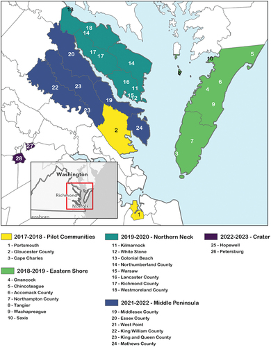
The RAFT was piloted in three communities beginning in 2017—the City of Portsmouth in Hampton Roads (pop. 94,838 in 2017Footnote2), the Town of Cape Charles on the Eastern Shore (pop. 1,012 in 20171), and Gloucester County in the Middle Peninsula (pop. 37,295 in 2017Footnote3). Subsequent implementations occurred during 2018 and 2019 that included 7 additional localities located along Virginia’s Eastern Shore (see ), followed by the Northern Neck and Middle Peninsula regions.
Figure 2. Location of RAFT implementation communities.
Because the initial focus of the RAFT was sea level rise (SLR) and coastal flooding, the bulk of the implementation efforts to date have centered on these specific climate-hazards and involved localities where these issues are of concern; but beginning in 2022, the RAFT Team turned its sights inland and began working to expand the geographic and substantive scope of the RAFT. The cities of Hopewell and Petersburg are part of the Richmond Metropolitan Statistical Area (MSA) and are members of the Crater planning district commission (PDC), which is the regional planning organization serving this portion of Virginia. The RAFT implementation phase began there in February 2023, but because Hopewell and Petersburg are located inland, the climate hazards that emerge as the process moves forward will not center on sea level rise. Instead, a more expansive understanding of resilience has so far characterized meetings between the RAFT Team and local stakeholders. For example, in Petersburg, increasing access to parks and greenspace that provide relief from urban heat as well as recreational opportunities, expanding mobility options for lower-income residents to increase their access to jobs and needed services, and diversifying the City’s economic base so it can better withstand times of stress have been identified as priorities for increasing the community’s overall resilience alongside more conventional resilience goals like protecting critical infrastructure.
Locating the RAFT—resilience planning frameworks
Several frameworks have been presented to help communities structure and begin working toward climate resilience. There is considerable overlap between hazard mitigation planning and climate resilience, with the latter having been more explicitly incorporated into recent federally mandated planning guidelines established by the Federal Emergency Management Agency (FEMA). Similarly, a concerted effort has been made to centralize and “surface” the many resources and best practices that have emerged from FEMA and other federal agencies. The US. Climate Resilience Toolkit and its Steps to Resilience (StR) framework points out the need to bridge silos and more effectively disseminate knowledge to support local resilience initiatives. In addition to federal and state governments, universities have also played an important role in supporting and structuring these efforts, as exemplified by the Action-Oriented Stakeholder Engagement for a Resilient Tomorrow (ASERT) framework. The following section of this paper highlights three alternative frameworks, then describes how the RAFT draws upon the strengths of each to forge a different paradigm for resilience planning-one that centers facilitation and community engagement as a means of leveraging and reconciling both professional expertise and the lived experience of residents and other local stakeholders.
Hazard mitigation planning (FEMA)
The Disaster Mitigation Act of 2000 (DMA) required that all local governments in the United States adopt hazard mitigation plans approved by the Federal Emergency Management Agency (FEMA) in order to be eligible for federal pre- and post-disaster mitigation funds. The possibility of experiencing a disaster without financial support from the federal government can be a significant motivation for local governments to engage in hazard mitigation planning. In fact, an estimated 85% of the US population lives in communities with a current hazard mitigation plan in place as of 30 June 2023 (FEMA, Citation2023a). Since 2015, state governments have been required to include the anticipated effects of climate change in their hazard mitigation plans in an effort to compel and “mainstream” preparation for the threats posed by a changing climate (Stults, Citation2017).
While there is obvious overlap between hazard mitigation and adaptation planning, “climate change results in spatially dispersed and systemic impacts, while natural hazards are generally localized, episodic events,” magnifying spatial and temporal uncertainties (Bedsworth & Hanak, Citation2010, p. 480). Effective climate adaptation planning requires an acknowledgment that future conditions are likely to be significantly different than past conditions, yet risk assessment for hazard mitigation planning has traditionally been based on historical trends and recorded events. Some jurisdictions have integrated their climate adaptation planning activities into more established and prescriptive multi-hazard mitigation planning initiatives (e.g. Baltimore, Maryland), while others have opted for a standalone plan that centers on the specific challenge of anticipating the impacts of climate change (e.g. Santa Monica, California). There is evidence that plans with a narrower focus perform better than broad, multi-hazard plans (Lyles et al., Citation2018), which underscores the value of explicitly preparing for climate impacts in a manner that is coordinated with, but distinct from hazard mitigation planning.
There are clear similarities between the well-established FEMA prescription for how to prepare a hazard mitigation plan and frameworks that have emerged to guide climate resilience planning (Matos et al., Citation2022; Stults, Citation2017). FEMA’s Local Mitigation Planning Handbook (Citation2023b) provides a framework for developing a hazard mitigation plan that is likely to pass regulatory review and receive federal approval consisting of four steps and nine tasks. Step 1 involves assembling the people (e.g. planning team, cross-jurisdictional coordination) and resources (e.g. data, meetings logistics) needed to complete the plan. Step 2 is devoted entirely to conducting a risk assessment, while Step 3 focuses on developing a mitigation strategy after reviewing community capabilities (e.g. planning and regulatory; administrative and technical; financial; and education and outreach). The final step centers on plan adoption and implementation. While the framework is graphically displayed as a linear process, FEMA guidance explains that the process is meant to be iterative, especially given the requirement for updating approved hazard mitigation plans every 5 years. The current version of the Local Mitigation Planning Handbook released in May 2023 differs from the previous version published in March 2013 in a few notable ways. First, the current version explicitly engages with climate change in a more extensive manner than the one-half page it garnered in the 2013 version (see pages 5–8). In addition to climate action and climate adaptation plans listed alongside comprehensive plans as key mechanisms for mitigation planning, the current Local Mitigation Planning Handbook includes numerous statements like “climate change is causing more frequent and intense events” (p. 53) and presents a brief case study of a climate resilience plan from San Francisco as an example of how a single plan might combine natural hazards and climate change. The handbook defines resilience as the “ability of a community to prepare for anticipated hazards, adapt to changing conditions, and withstand and recover rapidly from disruptions” (p. 136). Similar to the more intense focus on climate change, the most recent version of the Local Mitigation Planning Handbook engages with the equity implications of hazard mitigation beyond the identification of vulnerable populations. The word “equity” appears in the 2023 version 50 times, versus zero instances in the 2013 Local Mitigation Planning Handbook; and the current version also includes an explanation of what procedural, structural, and distributional equity mean in the context of hazard mitigation and how these principles should inform the development of plans.
Steps to Resilience (StR)
The US. Climate Resilience Toolkit (CRT) was launched in 2014 and represents the first attempt to coordinate and package the tools, data, and case studies that had been created by multiple federal agencies into a single, centralized platform. The Steps to Resilience (StR) framework is central to the CRT and offers practical guidance for communities, but when it was originally released it did not explicitly mention equity or environmental justice as factors to be weighed alongside “financial costs, environmental or social impacts, esthetics, or other value systems” (Gardiner et al., Citation2019, p. 481). The StR defines resilience as “the capacity of a community, business, or natural environment to prevent, withstand, respond to, and recover from a disruption” (CRT, Citation2023b) and perhaps this understanding of resilience is one of its limitations. In fact, one of the enduring critiques of resilience as a compass for planning has been that there is often too much emphasis on returning to conditions that prevailed before a disaster or other disruption. When we understand resilience as “a refinement of actions to improve performance without changing guiding assumptions or the questioning of established routines” (Pelling, Citation2011, p. 23), we reify the status quo. Without an examination of underlying conditions or interrogation of current practices, adaptation strategies may overlook or reinforce existing inequitable conditions. The current version of StR has evolved in response to critiques such as those offered by Gardiner et al. (Citation2019) but also now places greater emphasis on synthesizing knowledge and bridging silos among federal agencies. For example, the US. Department of Transportation has used the technique of pairing assets with hazards that could affect them as a strategy for catalyzing and focusing discussions among stakeholders related to vulnerability of transportation assets. This approach has been integrated into the first of the five steps presented as part of the current StR framework.
One of the strengths of the StR framework has been its use of short videos that explain each of its five steps in detail using accessible language. The first of these steps – Understand Exposure – involves conducting an inventory of assets in the planning area in addition to the hazards faced by those assets. This echoes the first step of FEMA’s hazard mitigation planning model, although StR defines assets as “the tangible and intangible things people or communities value” (CRT, Citation2023a) and takes an inductive approach to identifying them:
“Identify your assets by asking questions such as: What features, services, and opportunities make this a good place to live and work? What neighborhoods, historic sites, schools, tourist attractions, or retail centers make this place special? Consider physical, social, and economic assets across your location.” (CRT, Citation2023c)
By contrast, FEMA offers a more narrowly prescribed definition of assets (i.e. the people, structures, facilities, and lifelinesFootnote4 that have value to the community). In addition to direct links to relevant data sources from agencies like the National Oceanic and Atmospheric Administration (NOAA), the StR framework is closely coupled with case studies that illustrate how communities around the United States have approached each of the five steps. One of these case studies describes how the potential effects of drought and flooding on agricultural production in the US. Corn Belt were summarized and shared with farmers and crop advisors as part of the foundational work of building climate resilience. A distinction is made between climate stressors (e.g. more intense rainstorms) and non-climate stressors (e.g. the expansion of impervious surfaces with respect to flooding), which is valuable when the time comes to develop a course of action because climate stressors and non-climate stressors are likely to have different “levers” or mechanisms for intervention.
Step 2 focuses on vulnerability and risk assessment with sensitivity, adaptative capacity, and exposure as the determinants of vulnerability to a particular climate-related hazard (Adger, Citation2003). Based on the assessment of an asset’s sensitivity (i.e. the degree to which a system, population, or resource is or might be affected by a hazard) and adaptive capacity (i.e. ability of a person, asset, or system to adjust to a hazard, take advantage of new opportunities, or cope with change), a vulnerability rating of “Low,” “Medium,” or “High” is assigned for each entry in the list of asset-hazard pairs from Step 1. Then, this vulnerability assessment is used to characterize risk – which reflects both the magnitude of negative impacts and the likelihood of occurrence, based on predictions of future climate conditions – faced by each asset.Footnote5 Once the vulnerability and risk assessments have been completed, the recommended strategy from the StR framework is to address the assets with the greatest level of risk first.
The third StR step emphasizes the generation of ideas, review of case studies from other communities and a deliberative process where participants consider potential solutions and perhaps revisit the overarching resilience goals. Notably, this step assumes an open and inclusive decision-making process, but provides little concrete guidance on how to create and sustain this critically important component. The extent to which professional facilitation is needed and strategies for encouraging public participation are largely absent. However, there is a downloadable spreadsheet with a list of potential stakeholder groups to begin the outreach and engagement process.
Step 4 of the StR – Prioritize and Plan – is fundamentally about synthesizing the outcomes of the preceding steps and charting a path that maximizes the likelihood of reducing risk across the most threatened and important assets. This is where factors like budget constraints, limits of implementation authority, and staffing levels are used to further refine and crystallize which actions should be prioritized. Benefit-cost ratios are one of the tools that may be used during this step, but the most powerful tool may be the matrix provided that asks stakeholders to consider the following outcomes and to rate each of the potential solutions that emerged from Step 3 as “Not Feasible,” “Potentially Feasible,” or “Feasible:”
Ability to Increase Resilience
Economic Feasibility
Low Environmental Impact
Ability to Implement
This matrix facilitates discussion and refinement of priorities and tradeoffs in the face of the unique constraints that each community must consider and operate within when planning for climate resilience. It also makes it easier to identify solutions that deliver benefits that exceed their costs (No Regrets), are low cost but could have potentially large benefits under a changing climate (Low Regrets), enhance climate resilience while delivering other benefits (Win–Win) and are useful for dealing with uncertainties associated with longer-term climate change (Flexible) as articulated by P. R. Berke (Citation2014).
The final step – Take Action – offers suggestions for implementation, monitoring, and regular revisions to climate resilience initiatives that emerge from the StR process. Resources and case studies designed to de-mystify these less glamorous aspects of planning are presented, including a toolkit for engaging residents through citizen science campaigns (e.g. crowdsourced temperature collection to map heat islands).
The StR framework and the broader US. Climate Resilience Toolkit bring a wealth of existing data, tools, and best practices together in one centralized location where communities can quickly learn about climate change impacts that are expected to affect them and begin marshaling a response. Both tools and case studies can be filtered by region and corresponding StR step, which helps to further increase the legibility and likelihood that these resources will be discovered and adapted to fit local needs.
Action-Oriented Stakeholder Engagement for a Resilient Tomorrow (ASERT)
A third framework for climate resilience planning that serves as a useful contrast for the RAFT was developed by researchers at Old Dominion University (ODU) in Virginia and aims to push beyond conventional forms of public participation and stakeholder engagement. The Action-Oriented Stakeholder Engagement for a Resilient Tomorrow (ASERT) framework, first piloted in 2016, centers geospatial data visualization, participatory mapping, and gamification as tools for achieving more active and meaningful stakeholder engagement (Yusuf et al., Citation2019). Geospatial data are integral to ASERT and the ODU researchers trace this in part to structured public involvement (SPI), which has been widely applied in the context of transportation planning (Bailey & Grossardt, Citation2010). SPI integrates facilitation, local knowledge, professional expertise, and technologies like interactive polling within a collaborative decision-making process. During the pilot for the framework in Hampton Roads, Virginia, the ASERT researchers used ESRI mapping software to both collect information from participants (e.g. location and importance of community assets using Survey 123) and to present those collective insights and place them in context (e.g. relating a coherent narrative through a Story Map). This bi-directional exchange of knowledge helps to ensure that the research is grounded in and reflective of the priorities of residents and other stakeholders, while offering an accessible mechanism for sharing the results of the project with the public. There is also an element of gamification with stakeholders using Nintendo Wii video game controllers during public engagement events to actively explore the impacts of sea level rise under different scenarios.
The ASERT framework aligns closely with the current version of the FEMA hazard mitigation planning process and the StR framework. It leverages participatory mapping and tools like ESRI software to identify community assets and challenges, introduces information on strategies that have been successful in other contexts, then creates a space for discussion and deliberation about which resilience actions should be prioritized and implemented (Yusuf et al., Citation2019). However, in contrast to the StR framework, ASERT is targeting a broader audience of “policymakers, planners, community leaders, and others” with an explicit goal of facilitating multi-sector collaboration (Yusuf et al., Citation2019). Notably, the ASERT framework was used for the community outreach component of the award-winning Sea Level Wise Adaptation Strategy developed by Dewberry consultants in partnership with the City of Virginia Beach (City of Virginia Beach, Citation2020).
The RAFT as community-based adaptation
Several characteristics distinguish the RAFT from the preceding examples as a framework and paradigm for climate resilience planning. First, the RAFT recognizes the value that a trained and experienced facilitator can add to resilience efforts. The RAFT Team plays a vital convening and facilitation role throughout the 18-month process, compiling information from local government staffs and translating research to action, but also shepherding the infusion of local knowledge and priorities within the context of a larger, deliberative process. As a result, the RAFT is a process that cannot be hurried and that does not bend to the timelines of academic researchers nor local elected officials. Because expectations are established at the outset, the engagement can unfold organically and in a way that is responsive to the often unique conditions on the ground. Further, the RAFT recognizes that existing plans, regulations, and development management ordinances directly shape where people, infrastructure, and community assets are located, and therefore represent contributors to vulnerability as well as potential levers that can be used to advance climate resilience. Because the RAFT proceeds from an evaluation of relevant plans and ordinances, it immediately begins formulating a picture of how the existing landscape of vulnerability came to be and reveals potential solutions. The systematic nature of the RAFT Scorecard ensures that vulnerable populations are not overlooked and that necessities like food and medical care (e.g. FEMA’s Community Lifelines) do not fall through the proverbial cracks.
However, it could also be argued that the RAFT incorporates the key strengths of each of the three alternative frameworks discussed. The FEMA handbook is principally a prescription for local governments to follow so that hazard mitigation plans are more likely to meet the requirements of regulatory review and gain approval. The “carrot” of state and federal funding has shaped hazard mitigation planning in a powerful way and contributed to its spread over time. This influence, along with the emphasis on plan evaluation that emerged from studies of land use planning in the 1990s (Baer, Citation1997; Kaiser et al., Citation1995) can be clearly seen in the RAFT Scorecard. A rigorous assessment of existing plans and development regulations allows the RAFT Team to begin understanding what is possible in the near-term to advance climate resilience goals – and perhaps to conform with state or federal planning mandates. Appendix A contains a sample of the RAFT Scorecard that includes the individual indicators and an explanation of how to perform the scoring as well as how to interpret the scores.
Similarities with the Steps to Resilience (StR) framework include an emphasis on case studies from past implementation efforts as a source of actionable insight. Although more limited in scope than the repository of state and federal resources available with the US. Climate Resilience Toolkit, the RAFT website includes direct links to tools, risk maps, and case studies that have been produced through previous implementations (see ). A series of case studies from the 2019–2020 RAFT implementation in Virginia’s Northern Neck region are available on the Institute for Engagement & Negotiation (IEN) website and provide background on each of the 8 participating jurisdictions (IEN, Citation2023). In contrast to the StR case studies, the RAFT community case studies provide direct access to the Scorecard, Resilience Action Checklist, and maps showing the results of the vulnerability assessment aspects of the process for each community in a uniform way. These case study pages provide multiple examples of how the different phases of the RAFT process () were conducted as well as how the key products of each phase (e.g. Scorecard, RAC) complement one another to support collaborative climate resilience planning. Along with the written summary, presentation slides, and video recordings of the Phase 2 meetings, the case study materials offer a tangible blueprint for climate resilience work that does not gloss over the nuts-and-bolts of facilitation and engagement that often determine success.
Universities are important intermediaries when it comes to climate resilience, as evidenced by the ASERT framework discussed above. In the United States, trust in government continues to erode (Pew Research Center, Citation2022), and when coupled with the erratic leadership on climate at the federal level, the importance of grassroots advocacy and local action increases dramatically. Like the ASERT framework, the RAFT seeks to expand the reach of climate resilience planning to include constituencies and voices beyond the “usual suspects” of local government staff, environmental advocacy groups, and more affluent households. The RAFT Scorecard includes multiple indicators that specifically center vulnerable populations and encourage their active participation. The RAFT Resilience Action Workshop is designed to encourage inclusive and collaborative deliberation that makes use of professional expertise and the lived experience of residents and other local stakeholders. Acting as a liaison between university and the community is one of the most impactful characteristics of frameworks like ASERT and the RAFT precisely because crafting a successful response to the challenges of climate change and the specific threats posed to a given community requires the knowledge, resources, and capabilities of both. What separates the RAFT in particular from the other three examples discussed above is its emphasis on integrating the technical and regulatory aspects of planning with the social and deliberative aspects of climate action. This allows the RAFT to support and empower communities by using its members’ knowledge and experiences to “shape planning solutions” (Lieberknecht, Citation2022). The RAFT is a much more resource- and labor-intensive process than most resilience-building efforts because it reaches into the grassroots of communities to obtain and incorporate input from a broad swath of residents. However, it is precisely this kind of sustained engagement that increases the likelihood of identifying and pursuing more equitable resilience strategies (Yusuf et al., Citation2022).
Lessons from expanding and adapting the RAFT
In a separate pilot project in 2023, UVA researchers and IEN staff adapted aspects of the RAFT and a self-scoring process developed by the RAFT Team, the Planning for Resilience Evaluation and Prioritization (PREP) ToolFootnote6 (RAFT, Citation2021), to support inland flood resilience planning efforts in southern Virginia. The study region included the City of Martinsville, the Town of Halifax, and the Town of South Boston, with the Southside Planning District Commission as the primary partner. The goals of that project were to better understand how the RAFT and PREP Tool may need to change as they began to be deployed outside of the coastal zone and to develop a “roadmap” for the three study localities to create a resilience plan that meets the regulatory requirements of the Virginia Community Flood Preparedness Fund Grant program. After compiling comprehensive plans, floodplain ordinances, and zoning codes from the participating localities, a set of indicators was developed based on the criteria established by the Virginia Department of Conservation and Recreation (DCR) for proposals requesting flood resilience funds (Virginia Community Flood Preparedness Fund Grant Program) that also incorporated elements of the RAFT and PREP Tool. This plan and ordinance review instrument is available in Appendix B and adopts a plan evaluation scoring system (P. Berke et al., Citation2015) to identify areas of strength and potential gaps between the documents considered and the review criteria.
As a result of the plan and ordinance evaluation work performed, a few overall trends emerged:
The plans reviewed incorporated current data and drew upon a strong evidence base. These plans often described historical flood events as context for present-day flood risk and flood impacts, however, projections of future flooding are typically not part of these documents. This may be due to a lack of access to or awareness of resources that estimate future flood risk and represent an opportunity for strengthening the locality plans as they exist today. Perhaps not surprisingly, the regional hazard mitigation plans engaged with flooding and flood resilience in a much more comprehensive manner and each exhibits a clear connection to flood control and resilience, which is one of the core criteria established by DCR.
All plans reviewed clearly made use of the best available science to inform decisions, incorporating data and scientific analyses.
Regulations that are more specific better address the assessment questions (i.e. align with DCR regulatory review criteria).
Generally, the plans reviewed scored well on the criteria related to clearly articulated timelines for implementation and cross-jurisdiction coordination.
Zoning ordinances are the most comprehensive and readily available regulatory instrument for advancing flood resilience.
Alignment with the equity criteria outlined by DCR as part of its requirements for resilience plans could be improved by incorporating assessments of socially vulnerable populations (e.g. define and map) and discussing how past inequalities may contribute to present-day patterns of uneven flood risk (as well as strategies for addressing these disparities). While there was often evidence of public participation in the planning process with documentation of community engagement efforts, more explicit efforts to bring vulnerable community members into the planning process would better align with these required DCR review criteria.
The evidence supporting nature-based infrastructure as a tool for flood mitigation was quite strong in all the plans. However, there may be additional opportunities to educate residents about the benefits of natural resource protections and to better integrate green infrastructure (e.g. open space requirements) into existing land subdivision ordinances.
Helping local governments to understand how existing plans and ordinances can be strengthened and better aligned with the requirements of an administrative review was an important outcome of this project, but not the sole objective. In order to effectively plan for flooding, localities need to have adequate staffing, training, and other resources in place to support their work. These “soft capacities” were evaluated through (1) an online survey of local government staff and elected officials conducted in the summer of 2022, (2) a virtual focus group meeting held in November 2022, and (3) a series of five key informant interviews conducted between January and February of 2023.
Based on the online surveys, virtual focus group engagement event, and key informant interviews, it was determined that the financial resources to support flood resilience planning and flood mitigation work are rarely sufficient to fully address realities that participating localities face. Respondents to the local government staff survey indicated that funding was the most significant barrier to flood resilience by a wide margin followed by the demands on staff time (e.g. police, public works) and additional government expenses (e.g. overtime pay) when floodwaters impact roads.
In addition to the scarcity of funding, staffing levels in many localities within the study area are not adequate. Local government organizations have seen numerous retirements over the past few years, but it has often been a challenge to fill vacant positions. A reduction in local government staffing levels has also meant an effective increase in workload for staff members that remain, which makes training new hires difficult from a time allocation perspective. However, it should be noted that despite these challenges, all participating jurisdictions have a designated Floodplain Administrator and two of these three individuals either participated in the November 2022 engagement event or completed the online survey. Further, the existence and adequacy of succession plans is not reflected in the planning documents reviewed and may be internal to each locality. However, local government staff from all three jurisdictions indicated during the November 2022 event that there is an awareness of their importance, but succession plans are not widely available in local government outside of the Standard Operating Procedures (SOPs) for police and fire personnel. When longtime employees retire, they often take valuable institutional knowledge with them that is difficult to capture. The results of the plan and ordinance evaluation (i.e. inspired by the RAFT Scorecard) and the assessment of “soft capacities” were presented to the local partners along with a stakeholder map with the assumption that the localities and regional planning organization will use these resources as input to a more robust engagement process in lieu of a RAFT-style Resilience Action Workshop and implementation period.
This pilot project was not a comprehensive implementation of the RAFT process, and these deviations may have ultimately limited the effectiveness of the work. Because this project was conceived as research, a considerable amount of time and effort was devoted to gaining Institutional Review Board (IRB) approval for the online surveys, focus groups, and interviews. The IRB review is foundational to conducting research in an ethical manner (e.g. principles like informed consent) and is required if the intent is to publish, but it also serves as an example of how the timelines and priorities of university researchers often do not align with those of local government. In the case of this pilot, the standard 18-month process was compressed into a one-year target, which meant substituting surveys, focus groups, and key informant interviews for the longer deliberative process that brings stakeholders together to hear and be heard. Further, the focus groups and interviews were conducted via Zoom, which is convenient for some stakeholders (e.g. local government staff) but may be a hardship for residents with unreliable internet connections or inflexible work hours. In retrospect, this pilot lacked the sustained engagement with these communities that would have typically been part of the full RAFT implementation process. There is simply no substitute for visiting a place, meeting with stakeholders face-to-face, building trust, obtaining recommendations from stakeholders for additional community leaders to invite to join the process in order to get the fullest representation possible and discovering shared values over time. Future efforts to extend the RAFT inland should not shorten the 18-month timeline that has proven successful since 2017 and should avoid sacrificing the in-person, deliberative activities that characterize Phase 2 of the process ().
In addition to the pilot project in southern Virginia, RAFT was also expanded in January 2023 to more fully address social equity issues. In working with localities in the Northern Neck, the RAFT Team had observed that many of the grassroots service organizations worked on a regional basis, in this case across both the Northern Neck and Middle Peninsula of Virginia, and that the resilience challenges identified by these organizations with the most vulnerable populations were not bound by political boundaries. With funding from the Jessie Ball duPont Fund, responding to the expressed need for coordinated, collective, and integrated action across these two regions, the RAFT Team added a Regional Resilience Equity Workgroup encompassing 10 counties in the regions that participated in the RAFT. The Workgroup created a space where community service organizations can collaborate; identify priority risks and share information on the resilience needs of underserved and vulnerable members of the community; and above all, take coordinated action to address these needs. Membership included the planning district commissions, indigenous Tribes, state agencies, nonprofit organizations, and resource councils. In order to enable focused discussions, the Workgroup was divided into six subgroups to address their highest priority resilience needs for vulnerable populations: Economic Development & Living Wages, Healthcare & Mental Wellbeing, Food Security, Affordable Housing & Shelters, Transit, and Programs for Youth & Families. The Workgroup process reaffirmed a number of important concepts, including that resilience should be a community-wide discussion, with decisions made with the fullest input and participation possible; and that it takes concerted effort, time, and resources to build relationships and trust and obtain broad community input and participation. The Workgroup priorities also made it clear that core socio-economic needs, so often overlooked in resilience planning, must be addressed in climate adaptation efforts in order to foster and advance climate equity.
The intense level of effort required to conduct the scoring, the interviews and listening sessions for the qualitative assessments, the community development of resilience action priorities, the implementation support for a year, and the Regional Resilience Equity Workgroup requires a level of funding sufficient to support adequate staffing at the three university partners. The RAFT is not funded by the state government; it comes from a variety of sources, so finding adequate, consistent funding has been and continues to be a challenge for the RAFT Team.
Discussion and conclusions
Building upon on the success of federally mandated hazard mitigation planning offers one path forward for elected officials, advocacy groups, and residents interested in normalizing planning for climate resilience. However, climate change has been politicized in the United States, which hampers federal action while making climate resilience planning at the local level even more urgent. The jarring oscillations on climate policy that have occurred at the federal level over the past two Presidential Administrations offer a prime example of the tension between representative democracy and maintaining a sustained commitment to mitigating and adapting to a changing climate. While the current level of political polarization shows no sign of abating in the near-term, grassroots approaches that leverage the skills and experience of professional facilitators while drawing upon and reinforcing social connections, working through community-based organizations (e.g. churches), and educating the public about climate change impacts are one mechanism for insulating resilience planning from the vagaries of state and national politics. The Resilience Adaptation Feasibility Tool (RAFT) process offers a proven model for local climate resilience planning that leverages the expertise and resources of universities without diminishing the principles of democratic governance or ignoring the need to make these processes more inclusive and equitable.
Supplemental Material
Download PDF (277.7 KB)Acknowledgements
For funding the authors thank the University of Virginia School of Architecture and the Virginia Community Flood Preparedness Fund Grant program. For research assistance, we thank Ari Bell, IEN Student Research Assistant.
Disclosure statement
No potential conflict of interest was reported by the author(s).
Supplemental data
Supplemental data for this article can be accessed online at https://doi.org/10.1080/26883597.2024.2364266.
Correction Statement
This article has been corrected with minor changes. These changes do not impact the academic content of the article.
Additional information
Funding
Notes
1. Examples include discouraging development in areas prone to flooding and preserving natural features.
2. U.S. Census Bureau (Citation2020a). “Annual Estimates of the Resident Population for Incorporated Places in Virginia: April 1, 2010 to July 1, 2019 (SUB-IP-EST2019-ANNRES-51).”
3. U.S. Census Bureau (Citation2020b). “Annual Estimates of the Resident Population for Counties in Virginia: April 1, 2010 to July 1, 2019 (CO-EST2019-ANNRES-51)”
4. Community lifelines are “the most fundamental services in the community that, when stabilized, enable all other aspects of society to function” and include communications, health/medical, and transportation (FEMA, Citation2023b, p. 1).
5. Prior to the release of the updated Local Mitigation Planning Handbook in 2023, one of the clearest distinctions between hazard mitigation planning and climate adaptation or climate resilience planning had been how the likelihood of occurrence aspect of risk was conceived. Earlier versions of the official FEMA guidelines relied on “backward looking” approaches for understanding risk that implicitly assumed that future climatic conditions would be similar to historical climatic conditions. For example, current research indicates that the ubiquitous 100-year floodplain maps used to regulate development and to communicate flood risk are outdated in many areas today and will become increasingly biased as the climate continues to change (Hart & Halden, Citation2019). However, the line between hazard mitigation and climate resilience planning has blurred considerably now that FEMA is explicitly engaging with climate change as such and referencing “forward looking” data as the basis for risk assessment in its most recent handbook.
6. The PREP Tool was created in 2021 by students at the Virginia Coastal Policy Center (VCPC) at William and Mary’s Law School and the Institute for Engagement & Negotiation (IEN) at the University of Virginia. The RAFT is a partnership between IEN, VCPC, and the Institute for Coastal Adaptation & Resilience at Old Dominion University (RAFT, Citation2021, p. 2).
References
- Adger, W. N. (2003). Social aspects of adaptive capacity. In J. B. Smith, R. J. T. Klein, & S. Huq (Eds.), Climate change, adaptive capacity and development (pp. 29–49). Imperial College Press.
- Andrews, E., Cobb, T. D., Covi, M., & King, A. M. (2021). Communities: Teaming up with companies, cities, states, academia (The RAFT) In A. Goodman & N. Mesa (Eds.), Collaborating for Climate Resilience (pp. 25–38). Routledge.
- Arnstein, S. R. (1969). A ladder of citizen participation. Journal of the American Planning Association, 35(4), 216–224. https://doi.org/10.1080/01944366908977225
- Baer, W. C. (1997). General plan evaluation criteria: An approach to making better plans. Journal of the American Planning Association, 63(3), 329–344. https://doi.org/10.1080/01944369708975926
- Bailey, K., & Grossardt, T. (2010). Toward structured public involvement: Justice, geography and collaborative geospatial/geovisual decision support systems. Annals of the Association of American Geographers, 100(1), 57–86. https://doi.org/10.1080/00045600903364259
- Bedsworth, L. W., & Hanak, E. (2010). Adaptation to climate change: A review of challenges and tradeoffs in six areas. Journal of the American Planning Association, 76(4), 477–495. https://doi.org/10.1080/01944363.2010.502047
- Berke, P. R. (2014). Rising to the challenge: Planning for adaptation in the age of climate change. In B. C. Glavovic & G. P. Smith (Eds.), Adapting to Climate Change: Lessons from Natural Hazards Planning (pp. 171–190). Springer.
- Berke, P., Newman, G., Lee, J., Combs, T., Kolosna, C., & Salvesen, D. (2015). Evaluation of networks of plans and vulnerability to hazards and climate change: A resilience scorecard. Journal of the American Planning Association, 81(4), 287–302. https://doi.org/10.1080/01944363.2015.1093954
- Boswell, M. R., Greve, A. I., & Seale, M. T. L. (2019). Climate Action Planning: A Guide to Creating Low-Carbon, Resilient Communities. Island Press.
- Bridges, T. S., Burks-Copes, K. A., Bates, M. E., Collier, Z. A., Fischenich, J. C., Piercy, C. D., Rosati, J. D., Edmond, J., Russo, E. J., Shafer, D. J., Suedel, B. C., & Vuxton, E. A. (2015). Use of natural and nature-based features (NNBF) for coastal resilience. US Army Engineer Research and Development Center, Environmental Laboratory, Coastal and Hydraulics Laboratory.
- City of Virginia Beach. (2020). Virginia Beach Sea Level Wise Adaptation Strategy. https://pw.virginiabeach.gov/stormwater/stormwater-planning/sea-level-wise
- Commonwealth of Virginia - Office of the Governor. (2021). Virginia Coastal Resilience Master Plan. https://www.dcr.virginia.gov/crmp/document/virginiacoastalresiliencemasterplan-print.pdf
- Dahl, K. A., Fitzpatrick, M. F., Spanger-Siegfried, E., & Schumann, G. J. P. (2017). Sea level rise drives increased tidal flooding frequency at tide gauges along the U.S. East and Gulf Coasts: Projections for 2030 and 2045. Public Library of Science ONE, 12(2), e0170949. https://doi.org/10.1371/journal.pone.0170949
- Gardiner, E. P., Herring, D. D., & Fox, J. F. (2019). The US climate resilience toolkit: Evidence of progress. Climatic Change, 153(4), 477–490. https://doi.org/10.1007/s10584-018-2216-0
- Hart, O. E., & Halden, R. U. (2019). On the need to integrate uncertainty into US water resource planning. Science of the Total Environment, 691, 1262–1270. https://doi.org/10.1016/j.scitotenv.2019.07.164
- Holling, C. S. (1978). Adaptive Environmental Assessment and Management. John Wiley & Sons.
- Hughes, S. (2015). A meta-analysis of urban climate change adaptation planning in the US. Urban Climate, 14, 17–29. https://doi.org/10.1016/j.uclim.2015.06.003
- Institute for Engagement & Negotiation—IEN. (2023). 2019-2020 Northern Neck. https://raft.ien.virginia.edu/2019-2020-northern-neck
- Insurance Information Institute. (2022). Storm surge risk by state by number of single-family homes and reconstruction value, 2020. https://www.iii.org/table-archive/220281/file
- Kaiser, E. J., Godschalk, D. R., & Chapin, F. S., Jr. (1995). Urban Land Use Planning (Fourth ed.). University of Illinois Press.
- Keenan, J. M. (2018). Types and forms of resilience in local planning in the US: Who does what? Environmental Science & Policy, 88, 116–123. https://doi.org/10.1016/j.envsci.2018.06.015
- Keith, L., Meerow, S., Berke, P., DeAngelis, J., Jensen, L., Trego, S., Schmidt, E., & Smith, S. (2022). Plan Integration for Resilience Scorecard™ (PIRS™) for heat: Spatially evaluating networks of plans to mitigate heat (Version 1.0). www.planning.org/knowledgebase/urbanheat
- Lambrou, N., & Loukaitou-Sideris, A. (2022). Resilience plans in the US: An evaluation. Journal of Environmental Planning and Management, 65(5), 809–832. https://doi.org/10.1080/09640568.2021.1904849
- Lee, K. N. (1999). Appraising adaptive management. Conservation Ecology, 3(2). https://doi.org/10.5751/ES-00131-030203
- Lieberknecht, K. (2022). Community-centered climate planning: Using local knowledge and communication frames to catalyze climate planning in Texas. Journal of the American Planning Association, 88(1), 97–112. https://doi.org/10.1080/01944363.2021.1896974
- Lyles, W., Berke, P., & Overstreet, K. H. (2018). Where to begin municipal climate adaptation planning? Evaluating two local choices. Journal of Environmental Planning and Management, 61(11), 1994–2014. https://doi.org/10.1080/09640568.2017.1379958
- Matos, M., Gilbertson, P., Woodruff, S., Meerow, S., Roy, M., & Hannibal, B. (2022). Comparing hazard mitigation and climate change adaptation planning approaches. Journal of Environmental Planning and Management, 66(14), 1–21. https://doi.org/10.1080/09640568.2022.2093171
- National League of Cities. (2020). Principles of Home Rule for the 21st Century. https://www.nlc.org/wp-content/uploads/2020/02/Home-Rule-Principles-ReportWEB-2-1.pdf
- Nordgren, J., Stults, M., & Meerow, S. (2016). Supporting local climate change adaptation: Where we are and where we need to go. Environmental Science & Policy, 66, 344–352. https://doi.org/10.1016/j.envsci.2016.05.006
- Parlow, M. J. (2007). Progressive policy-making on the local level: Rethinking traditional notions of federalism. Temple Political & Civil Rights Law Review, 17(2), 371–385.
- Pelling, M. (2011). Adaptation to climate change: From resilience to transformation. Routledge.
- Pew Research Center. (2022). Public Trust in Government: 1958-2022. https://www.pewresearch.org/politics/2022/06/06/public-trust-in-government-1958-2022/
- Resilience Adaptation Feasibility Tool—RAFT. (2021). Planning for Resilience Evaluation and Prioritization (PREP) Tool. https://raft.ien.virginia.edu/system/files/Final%20PREP%20Tool%20%2810.10%29.pdf
- Stults, M. (2017). Integrating climate change into hazard mitigation planning: Opportunities and examples in practice. Climate Risk Management, 17, 21–34. https://doi.org/10.1016/j.crm.2017.06.004
- U.S. Census Bureau. (2020a). Annual estimates of the resident population for incorporated places in Virginia: April 1, 2010 to July 1, 2019 (SUB-IP-EST2019-ANNRES-51). https://www2.census.gov/programs-surveys/popest/datasets/2010-2020/cities/
- U.S. Census Bureau. (2020b). Annual estimates of the resident population for counties in Virginia: April 1, 2010 to July 1, 2019 (CO-EST2019-ANNRES-51). https://www2.census.gov/programs-surveys/popest/tables/2010-2019/counties/totals/co-est2019-annres-51.xlsx
- U.S. Climate Resilience Toolkit—CRT. (2023a). Glossary. https://toolkit.climate.gov/content/glossary#Assets
- U.S. Climate Resilience Toolkit—CRT. (2023b). Steps to resilience overview. https://toolkit.climate.gov/steps-to-resilience/steps-resilience-overview
- U.S. Climate Resilience Toolkit—CRT. (2023c). Understand exposure. https://toolkit.climate.gov/steps-to-resilience/understand-exposure
- U.S. Federal Emergency Management Agency—FEMA. (2023a). Hazard mitigation plan status. https://www.fema.gov/emergency-managers/risk-management/hazard-mitigation-planning/status
- U.S. Federal Emergency Management Agency—FEMA. (2023b). Local mitigation planning handbook. https://www.fema.gov/sites/default/files/documents/fema_local-mitigation-planning-handbook_052023.pdf
- Woodruff, S., Bowman, A. O. M., Hannibal, B., Sansom, G., & Portney, K. (2021). Urban resilience: Analyzing the policies of US cities. Cities, 115, 103239. https://doi.org/10.1016/j.cities.2021.103239
- Woodruff, S. C., Meerow, S., Stults, M., & Wilkins, C. (2022). Adaptation to resilience planning: Alternative pathways to prepare for climate change. Journal of Planning Education and Research, 42(1), 64–75. https://doi.org/10.1177/0739456X18801057
- Woodruff, S. C., & Stults, M. (2016). Numerous strategies but limited implementation guidance in US local adaptation plans. Nature Climate Change, 6(8), 796–802. https://doi.org/10.1038/nclimate3012
- Yu, S., Newman, G., Berke, P., & Li, X. (2023). Plan integration for ecological resilience: examining factors associated with wetland alteration. Journal of Planning Education & Research. https://doi.org/10.1177/0739456X231187117
- Yusuf, J. E. W., Cobb, T. D., Andrews, E., Gladfelter, S., & Montrose, G. (2022). The Resilience Adaptation Feasibility Tool (RAFT) as an approach for incorporating equity into coastal resilience planning and project implementation. Shore & Beach, 90(4), 53–63.
- Yusuf, J. E. W., St John, B., Rawat, P., Covi, M., Nicula, J. G., & Considine, C. (2019). The action-oriented stakeholder engagement for a resilient tomorrow (ASERT) framework: An effective, field-tested approach for engaging stakeholders. Journal of Environmental Studies and Sciences, 9(4), 409–418. https://doi.org/10.1007/s13412-019-00556-x
Appendix A
RAFT Scorecard (see Supplemental Materials)
Appendix B
Plan and Ordinance Review Instrument
Each of the plans and ordinances identified were independently scored by two reviewers. The three possible scores for each plan or ordinance element are as follows:
(0) means no evidence of the indicator,
(1) means the indicator was suggested/inferred/identified but not in detail, and
(2) means the indicator was more fully described.
Those individual scores and averaged scores were reported in the tables below and are intended to highlight aspects of the plans and ordinances that directly align with a set of indicators based on the criteria established by the Virginia Dept of Conservation and Recreation for proposals requesting flood resilience funds (Virginia Community Flood Preparedness Fund Grant Program). This instrument also draws upon indicators from the RAFT Scorecard and the PREP Tool.
Table B1. Plan scores.
Table B2. Ordinance scores.
