Abstract
Two Portuguese naus from Vasco da Gama's second voyage to India, left behind to disrupt maritime trade between India and the Red Sea, were wrecked in May 1503 off the north‐eastern coast of Al Hallaniyah Island, Oman. The ships, Esmeralda and São Pedro, had been commanded by da Gama's maternal uncles, Vicente and Brás Sodré, respectively. A detailed study and scientific analysis of an artefact assemblage recovered during archaeological excavations conducted in Al Hallaniyah in 2013 and 2014 confirms the location of an early 16th‐century Portuguese wreck‐site, initially discovered in 1998. Esmeralda is proposed as the probable source of the remaining, un‐salved wreckage.
Abstract
في مايو 1503م تحطمت سفينتان من سفن الناوس البرتغالية من أسطول فاسكو دي جاما من رحلته الثانية للهند على الساحل الشمالي الشرقي لجزيرة الحلانيات في سلطنة عمان ،واللتان تركتا لتعطيل التجارة البحرية في المنطقة بين الهند والبحر الأحمر. السفينتان إزمارالدا و ساو بيدرو كانتا تحت قيادة كلاً من فيسنتي و براس صودري على التوالي أخوال فاسكو دي جاما. تأتي هذه الدراسة المفصلة والتحاليل العلمية للقطع الأثرية التي تم إكتشافها من خلال الحفريات الأثرية التي أجريت في جزيرة الحلانيات بين عامي 2013 و 2014 م لتؤكد أن الموقع يعتبر من أوائل مواقع حطام السفن البرتغالية للفترة من أوائل القرن السادس عشر، والذي قد تم إكتشافه بدايةً عام 1998م. تفضي الدراسة إلى أن بقايا الحطام المكتشفة قد تعود في المقام الأول إلى السفينة إزمارالدا.
Abstract
Duas naus portuguesas pertencentes à armada que Vasco da Gama liderou na sua segunda viagem à India ficaram no Índico para perturbar o comércio entre a India e o Mar Vermelho, naufragando em Maio de 1503 junto à costa nordeste da ilha Al Hallaniyah, no Omã. Aqueles navios, Esmeralda e São Pedro, eram liderados pelos tios maternos de Vasco da Gama, Vicente e Brás Sodré, respetivamente. O sítio foi descoberto em 1998 e escavado em 2013 e 2014. O estudo detalhado e análises científicas da coleção de artefactos recuperada durante a escavação arqueológica confirmam a localização do naufrágio de uma embarcação portuguesa do século XVI. Propõem‐se que os vestígios encontrados pertençam à carga não salvada da Esmeralda.
Dos naos Portuguesas, que permanecieron en la India tras el segundo viaje de Vasco de Gama para interrumpir el comercio marítimo entre ésta y el Mar Rojo, naufragaron en 1503 en la costa noreste de la Isla de Al Hallaniyah, Oman. Las naves, Esmeralda y São Pedro, habían sido comandadas por los tíos maternos de de Gama, Vicente y Brás Sodré respectivamente. El estudio detallado y el análisis científico de una colección de artefactos recuperados durante las excavaciones arqueológicas llevadas a cabo en Al Hallaniyah en 2013 y 2014, confirman la localización del pecio de una nave Portuguesa del siglo XVI temprano, inicialmente descubierto en 1998. Se propone que los restos no sometidos a salvamento pertenecieron a la Esmeralda.
(Traducción: Ricardo Borrero L, with thanks to the Honor Frost Foundation)
The Carreira da India, made annually by Portuguese ships since Vasco da Gama's discovery of the sea route to India in 1498, was a dangerous and often deadly journey for the ships and men that sailed it. In terms of ships lost, one study puts the number of total casualties at 219 for the period between 1498 and 1650 (Guinote et al., Citation1998: 105). Despite the large number of losses, very few India‐route shipwrecks have been found and, according to Castro, almost all had been heavily looted before archaeologists had the opportunity to study their remains (Castro, Citation2005: 26). Of the wrecks that have been found and identified, none can be conclusively dated earlier than 1552—the São João—leaving archaeologists with roughly a 50‐year gap in knowledge of many aspects of how the Portuguese conducted maritime trade and warfare in the Indian Ocean (Castro, Citation2005: 27). The Portuguese shipwreck discovered in Oranjemund, Namibia believed to be the Bom Jesus sunk in 1533, has yet to be conclusively identified or dated (Chirikure et al., Citation2010: 37). This gap coincides with an important and culturally significant period in the long history of Portuguese overseas expansion.
In an effort to partially fill this gap, research was begun into the documentary evidence for two early 16th‐century ship losses (1503) suffered by the Portuguese in the Indian Ocean with the aim of locating their wreck‐sites. The two ships, the naus Esmeralda and São Pedro, were the leading vessels of a five‐ship squadron of three naus and two caravels that formed an important part of Vasco da Gama's second voyage and the fourth Portuguese fleet to explore the Indian Ocean. The ships were commanded by the brothers Vicente and Brás Sodré, respectively, who were the maternal uncles of da Gama. This research concluded that the most probable location for the wrecks was the northern coast of Al Hallaniyah: the largest of the Khuriya Muriya Islands situated approximately 45 km off the southern coast of Oman, and it was the basis for a search expedition which initially located the wreck site in 1998.
The avoidable and costly loss of these ships and their valuable cargoes, which also resulted in the death of the Sodré brothers, is a well‐documented story that has been recounted numerous times over the centuries. The story's enduring interest stems in part from the direct familial connection with da Gama, but equally from the important military role played by Vicente Sodré during this voyage in accordance with separate instructions (regimento) given to him by the Portuguese King Dom Manuel I (1495–1521). Our research thereby benefited from a rich and extensive narrative of da Gama's 1502–1503 voyage to India, which also included the violent warfare and piracy conducted by the independent Sodré squadron and the tragic demise of the Esmeralda and São Pedro in a violent storm. Of the many accounts that exist, the most important for pinpointing the wreck location was the sole eyewitness account written by Pêro d'Ataíde, one of the other captains in the Sodré squadron (1504), and four of the Portuguese chronicles published later in the mid 16th century (CitationCorrêa, c.1550s; Barros, Citation1552; Castanheda, 1551–1560; and Góis, Citation1567).
Historical background
In 1502, four years after his discovery of the sea route to India earned him the titles Dom and Admiral of the Indies in addition to other royal grants, Vasco da Gama was once again appointed Captain‐Major by Dom Manuel I for a voyage to India. Following the disastrous outcome of Pedro Cabral's earlier (1500–1501) command of 13 ships, of which only six made it to the Malabar coast, da Gama was apparently a late replacement for Cabral of this 4th Portuguese voyage, which was central to the prestige and military ambitions of Dom Manuel. The Portuguese king's investment in the Indian Ocean had yet to turn a profit, nor had it resulted in finding large numbers of friendly Christians in India who could be allies against the Mamluks of Egypt who controlled the spice trade through the Red Sea. In fact, Cabral's relations with the Zamorin of Calicut were decidedly unfriendly. Continuing da Gama's policy of hostile trade, Cabral's fleet first seized a Muslim ship, which in turn precipitated a retaliatory attack by the enraged Muslim merchants on the newly established Portuguese feitoria in Calicut. Fifty‐four Portuguese, including the feitor Aires Correia, were killed in the ensuing battle. Cabral's reply to the heavy loss of his men and goods was to capture still more Muslim ships and then to bombard Calicut with his heavy guns, killing as many as 500 (Subrahmanyam, Citation1997: 181).
In replacing Cabral, Dom Manuel opted for a fleet that was full of military intent and family members of da Gama. Of the 20 ships, the largest Carreira da India fleet to date, five were commanded by present, or soon to be relations of da Gama, including: the Sodré brothers, a cousin Estêvão da Gama, a brother‐in‐law Alvaro de Ataíde, and a future brother‐in‐law Lopo Mendes de Vasconcelos (CitationLivro das Armadas da Índia, c.1497–1640). The main figure, however, other than da Gama himself, was Vicente Sodré, who was to assume the role of Captain‐Major if anything happened to his nephew. Sodré, who was both a knight of the Order of Christ and of the royal household, was given a separate regimento by Dom Manuel to use his partially independent squadron of five ships to ‘make war against the ships of Meca’ along the coast of Malabar and the entrance to the Red Sea (Barros, Citation1552: 87; Subrahmanyam, Citation1997: 190). In leaving Sodré’s smaller squadron behind, Dom Manuel was looking to forcibly control and dominate the spice trade by the naval power of his technically superior ships armed with heavy guns.
After da Gama returned to Lisbon in early 1503 with the main part of the fleet, Sodré was instructed to patrol the waters off the south‐west Indian coast. From this post he could protect the newly established Portuguese factories and their allies in Cochin and Cannanore from the inevitable Zamorin attacks, and still be able to capture Arab ships trading between the Red Sea and Kerala to fulfil the royal regimento. Sodré, however, ignored these instructions and instead sailed to the Gulf of Aden where his squadron captured and looted a number of Arab ships of their valuable cargoes (Subrahmanyam, Citation1997: 229). In conducting this high‐seas piracy, Sodré was abetted by his brother Brás in the São Pedro, who led brutal attacks that spared no lives as every ship was burnt after being plundered. According to Pêro d’Ataíde (Citation1504), who was captain of the third nau, the Sodré brothers kept the lion's share of the stolen cargoes (pepper, sugar, clothing, rice, and cloves), leading to dissension among the other commanders and crews.
In April of 1503, Sodré took his squadron to the Khuriya Muriya Islands off the south‐eastern coast of Oman to shelter from the south‐west monsoon and to repair the hull of one of the caravelas. They remained on the largest and only inhabited island (now known as Al Hallaniyah) for many weeks and enjoyed friendly relations with the indigenous Arab population, including bartering for food and provisions. In May the local fishermen warned the Portuguese of an impending dangerous wind from the north that would place their anchored ships at risk unless they moved to the leeward side of the island. Confidant that their iron anchors were strong enough to hold their naus in place, the Sodré brothers, along with Pêro de Ataíde, kept their ships in the northern anchorage, while the smaller caravels moved to a safe location on the other side of the island.
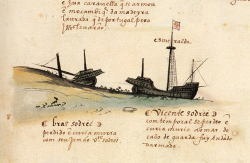
When the winds came, as the Arab fisherman had accurately predicted, they were sudden and furious and were accompanied by a powerful swell that tore the Sodré brothers’ ships from their moorings and drove them hard against the rocky shoreline smashing their wooden hulls and breaking their masts. An illustration in Livro das Armadas (c.1568) dramatically captures the demise of the two naus (Fig. 1). While most men on the São Pedro survived by scrambling across the fallen mast and rigging on to land, it was reported that everyone from the Esmeralda, including the squadron commander Vicente Sodré, perished in the deeper waters of the bay. Although Brás initially survived the wrecking of his ship, he later died of unknown causes; but not before he had two Moorish pilots killed, including the best pilot in all of India left to him by his nephew da Gama, in misplaced revenge for the death of his brother (Ataíde, Citation1504).
Figure 1. Illustration from the Livro das Armadas da índia, c.1568, depicting the loss of Brás and Vicente Sodré’s ships. The name below the Portuguese cross identifies Vicente's ship as the Esmeralda. (With permission, Academia das Ciências de Lisboa)
After burying their dead on the island, the surviving Portuguese spent six days salvaging as much as they could from the wrecks before setting fire to the hulls (Ataíde, Citation1504). Under the new command of Pêro de Ataíde, the three remaining ships sailed back to India where they met Francisco D'Albuquerque and, according to Ataíde, handed over 17 pieces of artillery they had salvaged from the wrecks. Ataíde later succumbed to illness and died in early 1504 after his ship wrecked near Mozambique during his return journey to Lisbon. Shortly before he died, however, Ataíde wrote a five‐page personal letter to Dom Manuel relating the events described above. This letter, the original of which is held in the Arquivo Nacional da Torre do Tombo in Lisbon, represents the most complete first‐hand account of what transpired with the Sodré patrol, and it is against this account that the Portuguese chronicles of Corrêa, Barros, Castanheda and Góis, were compared for the purpose of determining where to search for the wreck‐site.
Although no record exists of the Portuguese contemplating additional salvage of the wrecks, a letter to Dom Francisco de Almeida, first Viceroy of India, dated 10 September 1508, tells how a sworn enemy of the Portuguese got to the site first and apparently recovered the guns that Ataíde and the surviving crews left behind (ANTT‐CC, Citation1508). The guns, including 50 or 60 berços, two bombardas grossas and one falcaõ, where then in the hands of Malik Ayaz, who, as the governor of Diu and their main adversary in Gujarat (Pearson, Citation1976: 67), recently handed the Portuguese their first naval defeat in the Indian Ocean at the Battle of Chaul in March 1508. Undoubtedly the most upsetting fact for Almeida was that this valuable and strategically important collection of ordnance had been recovered from the Sodré wreck‐site in Khuriya Muriya. Almeida was already aggrieved that his son Lourenço had been defeated and lost his life in the battle, but now he learned that the guns Malik Ayaz used to inflict this blow were Portuguese. No doubt this provided extra motivation for Almeida to take his revenge against Malik Ayaz and the Egyptian‐Gujarati fleet, which he promptly did in early 1509 at the Battle of Diu (Pearson, Citation1976: 70).
Wreck location
A detailed comparative analysis of the primary and secondary accounts resulted in the wreck location being precisely described in geographic terms. The location was: 1) in the Khuriya Muriya Islands of Oman; 2) the island was inhabited; 3) it possessed a large cove sheltered from the west winds and with good holding for anchors; 4) a beach suitable for careening a caravel; 5) a shore line that was steeply banked; 6) the location supported an indigenous population of Moors that relied mainly on fishing; and 7) the anchorage was exposed to sudden and dangerous storm winds from the north. Our research also revealed that, except for the ships of the Sodré brothers, no early 16th‐century Portuguese East Indiamen were lost in this area.
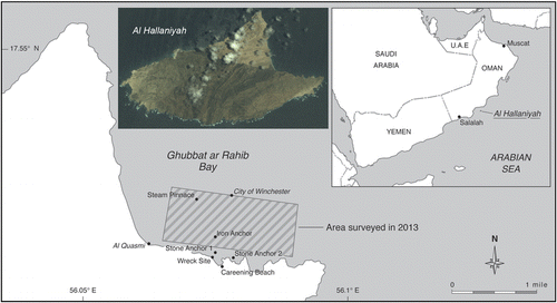
Of the Khuriya Muriya Islands, only Al Hallaniyah (Fig. 2), easily the largest of the group at 14.6×7.7 km, is recorded as ever having a substantial indigenous population in the past (Hulton, Citation1840: 185). An Admiralty chart produced after an 1837 hydrographic survey of the waters around the island showed two anchorages on opposite ends of the northern coast, each with a nearby well that would have been necessary to support a local population. One of the anchorages serves the present‐day village and is the site for a new port facility, while the anchorage off the far north‐eastern coast of the island in Ghubbat ar Rahib Bay is remote and, until early 2014, could only be reached by boat. Both anchorages are exposed to a dangerous northerly wind, known as the belatt, which is strongest in Khuriya Muriya Bay (Hulton, Citation1840: 190; UK Hydrographic Dept, Citation1987: 252).
Figure 2. Location of the wreck‐site and other cultural heritage material discovered within Ghubbat ar Rahib Bay. The 2.5 km2 area outlined by the hatched box was geophysically surveyed in 2013. (With permission, DigitalGlobe)
Armed with these clues, a two‐man reconnaissance team, authorized by the Oman Government, visited the island in May 1998 to search for the wrecks using visual methods and hand‐held metal detectors. After an exhaustive search of the north‐western anchorage proved negative, the team moved to Ghubbat ar Rahib Bay where they identified a location that closely matched all the geographical features of the wreck‐site as described in the contemporary accounts outlined above. During a short search of the seabed, more than 20 round shot made of stone, 95–220 mm in diameter, possibly indicative of a shipwreck, were visible on the seabed within a series of narrow sand‐ and rock‐filled gullies intersecting the bedrock that slopes into the bay. Water depths within the gullies ranged from c.2–6 m.
The site was revisited in late 1998 to conduct a more detailed reconnaissance survey of the bay, archaeological mapping of the gullies and stone shot, and trial excavations to determine the possibility of buried material and the likely depth of burial. More large round shot were discovered; some were limestone but all others were handmade from igneous rock and were identically carved with the letters ‘VS’. Surveys using a hand‐held metal detector led to the discovery of a lead sounding‐weight, a fragmented pewter plate, a perforated lead disc and a large area of concretion from which 23 lead‐iron composite shot were recovered. The shot were similar to those found on a number of 16th‐century shipwrecks, including the 1545 Mary Rose (Walker et al., Citation1989; Hildred, Citation2011: 348), the 1554 Padre Island shipwrecks (Arnold and Weddle, Citation1978: 250–1), and a suspected Portuguese wreck in the Seychelles (Blake and Green, Citation1986: 11).
While these finds strengthened the belief that the site could be where the Sodré ships wrecked and that a full‐scale excavation would yield more conclusive evidence, the logistical difficulty of supporting such a complex operation in this remote location led to the project being suspended. Following a series of meetings with Oman's Ministry of Heritage and Culture (MHC) the first author was able to address these challenges and a written agreement was signed with the MHC in April 2013 to jointly conduct and co‐manage the project on a collaborative basis. The MHC is the official government body responsible for the protection of Oman's underwater cultural heritage and their management of this project represents the first government‐led archaeological excavation of an historic wreck‐site in Omani waters. Although Oman is not a signatory to the UNESCO Convention for the Protection of Underwater Cultural Heritage, the agreement calls for all aspects of the project to be conducted to the highest‐possible scientific and archaeological standards and as a minimum to conform to the standards enshrined in the UNESCO Convention. Following conservation and archaeological analysis, the recovered artefacts will be preserved in a single coherent collection owned by the MHC for ultimate display in the new National Museum of Oman. Excluding grants awarded to David Mearns by the National Geographic Society Expeditions Council and the Waitt Foundation, funding for the project has been provided entirely by the MHC.
Subsequently, two more extensive investigations of the site have been conducted.Footnote1 In May 2013, a two‐week reconnaissance high‐resolution geophysical survey of the entire Ghubbat ar Rahib anchorage was conducted, along with repeat mapping of the stone shot locations in the gullies to determine whether there was any disturbance of the site or significant shifting of the surface artefacts. Fortunately there was none. However, because infrastructure development on the island would soon make the bay accessible by vehicle for the first time, thus dramatically increasing the risk of unauthorized disturbance to the site, the MHC decided that all surface artefacts should be recovered. These included a matched pair of copper‐alloy sheaves, a ship's bell that was found lodged under a large boulder, and a further 38 stone shot of various sizes.
The second expedition took place between April and May 2014 with the primary goal of excavating the wreck‐site confined within the shallow‐water nearshore gully. It was estimated that 950 cubic metres of sand and rock would have to be removed to excavate the site to bedrock, which necessitated the use of multiple airlifts driven by a large diesel‐engine air‐compressor. Over a 22‐day period nearly 40% of the site was successfully excavated leading to the recovery of an additional 1911 individual artefacts from the densest concentration of the wreck material. This paper, which is an interim report of this ongoing project, discusses the analytical study and interpretation of key artefacts that help to identify the site as the location where the Sodré ships were wrecked, and Vicente Sodré’s nau Esmeralda as the probable source of the remaining cultural material.
The site
Ghubbat ar Rahib bay is a natural anchorage off the north‐eastern coast of Al Hallaniyah Island (Fig. 2). Large stone anchors discovered in the bay indicate that it has been used in the past as an anchorage by ships in this region. The bay extends approximately 3.8 km from Ra's al Hallaniyah, a wind‐eroded limestone bluff projecting northward, to Ra's Sayyir the low‐lying eastern extremity of the island. Owing to its position in combination with the height of Ra's al Hallaniyah (501 m) and other internal peaks on the island rising to 503 m, the bay provides natural shelter from winds SE through S, to NW. However, the bay is fully exposed to the north and winds and swell generated during the north‐east monsoon. Depths in the bay slope gradually and uniformly to the north, while the fine, sandy bottom provides good holding for anchors.
Survey results
Two known steel shipwrecks located in the bay were investigated as part of the overall project to document all cultural material for Oman's MHC. The City of Winchester was a 6601‐ton British cargo steamer captured at the outbreak of WW1 by the Imperial German Navy and later scuttled after 400 tons of her bunker coal was removed (Walter, Citation1994). The wreck now lies in the centre of the bay, approximately 1300 m from shore, at a depth of 28 m (Fig. 2). In late 1999, a 750‐ton cargo ship, Al Quasmi, carrying 5‐litre containers of oil, ran hard aground and was left stranded in the south‐western corner of the bay. All that remains of this dismantled ship are some sections of the steel hull lying along the rocky shoreline and in the adjacent shallow water (Fig. 2).
A high‐resolution geophysical survey of the main anchorage area, encompassing 2.5 km2, was conducted at the start of the 2013 field season to map and investigate all anomalies that might represent archaeological material connected with the Portuguese squadron or other wrecks (Fig. 2). The survey was conducted in the highest‐possible detail using sidescan sonar (Edgetech 4125; 400/900 kHz), caesium magnetometer (Geometrics G822), echo‐sounding (Garmin 240) and sub‐metre GPS positioning equipment (C‐Nav 3050). The resolution and conditions were sufficient to detect seabed targets as small as 0.10 m and magnetic anomalies of 1 nT. Following the survey all anomalies were investigated by divers used hand‐held magnetometers and metal detectors as required.
The geophysical survey resulted in two prominent targets that were detected simultaneously by the sidescan sonar and magnetometer sensors. The first was identified by divers in 2013 as the remains of a small steam‐driven ship's boat or pinnace. The remains included a scotch boiler, valve gear, steam whistle, 2–cylinder engine and propeller shaft. No identifying marks were found on either the engine or boiler. The second target was a large iron anchor that was originally found with only the tip (c.0.8m) of one fluke exposed above the seabed. The rest of the anchor was deeply buried and was excavated during the 2014 field season using a water dredge. Once the whole anchor was exposed and measured it was found to be identical to another anchor on the site of the City of Winchester. This evidence strongly indicates that the anchor, as well as the pinnace, originate from the Winchester and were lost during the action with the Imperial German Navy.
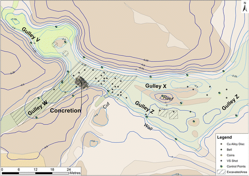
The rest of this article concerns the site of the Portuguese shipwreck (site code AH1) located within a series of narrow interconnected gullies, which intersect reef rock that slopes seaward from the foreshore. Three gullies have been designated: a major gulley Z, which initially runs perpendicular to shore and then parallel with it; a sub‐gulley X, which separates and re‐joins Z; and gulley W, which leads up on to shore and experiences considerable wave surge particularly at low tide (Fig. 3). The fill of the gullies is largely sand, boulders, rock scree and broken coral, with an underlying granite bedrock approximately 1 m below the current seabed. The fill most closely matches Grade 14 (Sandy Gravel) of Gregory's theoretical grade of preservation (Citation2006: 14). In gulley W the fill consists largely of boulders with relatively little sand. The maximum length of gullies over which finds have been recovered is 115 m, with the width of gullies ranging 5–18 m and water depths of 2–6 m. Despite the repeated searching of adjacent gullies with metal detectors and test trenches, no artefacts were found outside the confines of the site described above.
Figure 3. Plan of the wreck‐site showing the positions of the gullies, main concretion and area excavated in 2014. (T. Cousins, P. Holt)
Excavation methodology
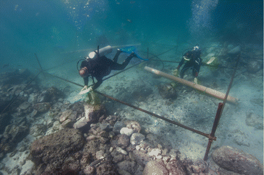
The site was divided into a series of adjoining 1 m grid squares using frames made up on location from 3 m‐long, 48 mm‐diameter steel pipes joined at the corners by four cross Kee Klamp® frame joints. The frames resulted in a series of 3×3 m grids that were further separated into nine 1 m squares using rope lines fixed with elastic cords. The frames were positioned as close to the seabed as possible and supported by adjustable legs (Fig. 4). All finds recovered from each square were individually numbered in relation to their grid position.
Figure 4. Divers working within the 3×3 m grid frames. (Photo: P. Holt)
Twenty‐one 3 m2 grids were excavated, which represents approximately 38% of the total area of the site (Fig. 3). The position and orientation of the frames was determined using conventional 3D tape trilateration (Direct Survey Method) referenced to a network of 15 fixed survey control points (CPs) installed on the seabed and positioned relative to each other, and in real world coordinates (WGS 84), using a combination of distance and depth measurements plus position measurements derived from GPS. The CPs were 8 mm‐diameter mild‐steel reinforcing bar, hammered into cracks in the rock and marked with yellow plastic discs. The position of each excavation frame was then calculated by taking three or four distance measurements and a depth measurement from the top of two diagonally opposite corner posts. The distance and depth measurements were adjusted using Site Recorder 4 software, which calculated the best estimate of position for each survey control point. After the adjustment, the measurements fit together to a precision of 15 mm (RMS residuals), with 51 distance and depth measurements used to calculate 15 CP positions. Surveys of this nature should achieve RMS residuals below 30 mm under normal diving conditions, so the results are better than expected given the considerable wave surge experienced on site.
Excavation involved the controlled removal of all sediment and finds within the area down to bedrock. Spoil was removed by airlifts and by hand in areas with delicate material. The site contained many rocks of boulder size between 25 kg and 1500 kg in weight. These were removed by placing them into one‐tonne‐bulk‐container bags and then moving these with the use of air bags, or, in the case of large boulders, by strops connected directly to the air bags. Boulders were either moved to an adjacent area away from the excavation, or, in some situations, depending on the available space, they were returned to the excavated area on completion of excavation work in order to backfill the excavated holes. Much of this work involved the use of hand fanning for the removal of sediment and the use 4 lb lump hammers, chisels and crowbars for the removal of more robust material. Where material was heavily concreted to the bedrock pneumatic chipping hammers were used to break up concretions and free the material held within.
The finds
The finds recovered to date1 are indicative of the contents and components of a ship, absent the ship itself. No hull timbers or large ship structures have been found. This is not surprising given: 1) the ferocity of the storm that drove the ships aground and undoubtedly continued to break the hulls apart; 2) the extent of contemporaneous salvage conducted by the surviving Portuguese, which included setting fire to the two ships (Ataíde, Citation1504); and 3) the shallowness of the site and lack of sediment cover to protect any remaining timbers from constant degradation in this high‐energy and biologically active environment. Nevertheless, our initial analysis and interpretation of the main groups of finds at this interim stage of the project provides ample evidence to identify the site as the location where the Sodré ships were wrecked.
Ceramics
Prior to the most recent excavation campaign in late 2015, the assemblage of recovered ceramics consisted of 554 objects, of which only two were small intact vessels with the remainder being sherds. The ceramics were directly observed by Tânia M. Casimiro of Universidade Nova de Lisboa at the MHC conservation laboratory in Muscat in January 2016, including the ceramics recently recovered in late 2015, making a total of 1039 sherds. Casimiro's assessment was some 52% of the objects were produced in Portugal using red micaceous fabrics that are usually related with the Lisbon area, with their shapes corresponding to everyday wares such as cooking pots, costrels, lids and cups (Fig. 5a‐d). Asian ceramics were also frequently identified with the presence of Ming productions such as Hongzhi porcelain (1488–1505), celadon plates and martaban (Fig. 6), and diverse blue‐glazed objects that were likely produced in Iran (Fig. 5f). West African pots, shaped and decorated to resemble baskets were also part of the collection (Fig. 5e). The absence of any Iberian tin‐glazed wares on the site should be noted. These are a constant presence in Portuguese terrestrial and underwater archaeological contexts from the second half of the 16th century onwards and are rare or non‐existent in earlier chronologies. In this sense, considering the type of ceramics found, the site can be broadly dated between 1450 and 1550 (Casimiro, pers. comm., unpublished report Jan 2016).
Figure 5. A sample of ceramics found on the site a) Portuguese cooking pot; b) Portuguese costrel; c) Portuguese cup; d) Portuguese lid; e) African pot f) blue‐glazed plate. (T. Casimiro)
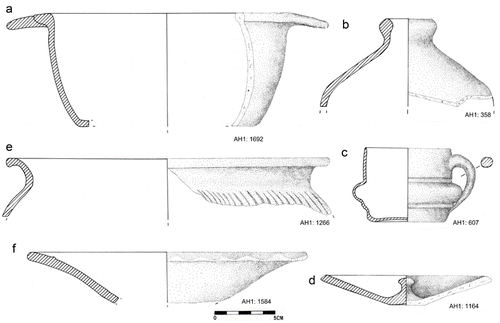
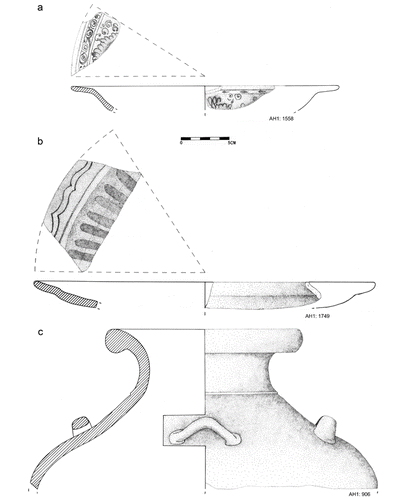
Figure 6. Chinese ceramics found on the site a) Hongzhi plate; b) celadon plate; c) martaban. (T. Casimiro)
Ordnance
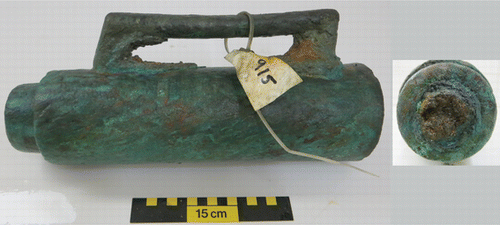
The quantity and variety of ordnance recovered from the site is indicative of a ship that was prepared for naval warfare. The bulk of the ordnance recovered was contained within a large concretion mixed with boulder‐sized rocks situated at the eastern end of gully W. In addition to numerous iron and composite lead shot, the concretion contained 19 copper‐alloy and one iron breech chambers, and three c.750 mm‐long thin copper‐alloy tubes that appear to be the barrels of some form of handgun. This concentration of ordnance suggests the ship was equipped with an armoury for the dedicated storage of weapons and munitions (Fig. 7). The copper‐alloy breech chambers were very similar in size, c.305 mm long, c.45 mm internal bore, and design. Each has a rectangular handle, a touch‐hole that was originally teardrop shaped, a spur at the base for locking the chamber in place by a wedge, and a tapered neck with the chamber‐mouth sealed with a wooden tampion (Fig. 8). As many have tampions sealed tightly in place, gunpowder may still be found within the chamber when they are more fully examined during conservation. Despite the relatively large number of breech chambers and large stone shot recovered, no heavy guns have been found to date. This absence is consistent with the history of salvage of the wrecks whereby both the surviving Portuguese, as per the account of Pêro d'Ataíde (Ataíde, Citation1504), and Malik Ayaz in 1508 recovered whatever guns were on board the two ships (ANTT‐CC, 1508).
Figure 7. Photomosaic of the upper surface of the main concretion. Five breech chambers and one gun barrel are visible. Divisions on the scale bars are 10 cm. (T. Cousins)
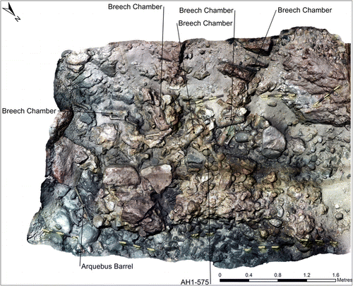
Figure 8. One of 19 copper‐alloy breech chambers recovered from the site. (Photo: D. Mearns)
Stone shot
A total of 91 round shot were retrieved from the site and examined. The handmade shot were all finished and made of two basic lithological types: limestone and igneous rock. Hand samples and thin‐section slides made from one of the limestone shot, of which nine were recovered, with an average diameter of 220 mm, were examined by Miguel M. Ramalho of the LNEG Geological Museum of Portugal. This examination revealed that the limestone shot was composed of calcareous rock bio‐intra particles with dispersed fine to medium quartz grains. The bioclasts, mainly echinoderms from crinoids, bivalves, and foraminifera (Neotrocholina), were generally broken and eroded. Intraclasts, consisting of fine to medium compact micrite, were very abundant and generally not eroded. No characteristic microfossils with stratigraphic value were found in the thin sections. Relative to Portuguese microfacies the rock is similar to Cretaceous (lower to middle Cenomanian) outcrops that occur around the Massif of Sintra (Berthou, Citation1973; Ramalho, M. pers. comm., unpublished report 21.10.2014).
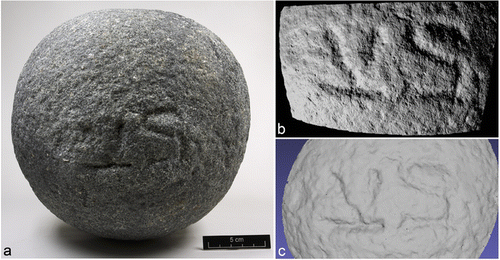
The shot made of igneous rock exhibited significant lithological diversity, ranging from felsic to intermediate igneous and meta‐igneous rock. Several of the shot exhibited a mineral foliation and incipient lineation suggesting a recrystallized, gneissose banding. The igneous shot came in two basic sizes: large shot of 220 mm diameter and 16 kg average weight, of which 35 were recovered, and smaller shot that ranged from 70 to 130 mm diameter and 0.42–1.65 kg, of which 47 were recovered. After the removal of biological growth and surface encrustation it was observed that the first igneous shot recovered in 1998 was marked with a carving of the letters ‘VS’ (Fig. 9a). This shot was scanned by both laser and structured‐light 3D scanners in order to visualize and precisely measure the ‘VS’ mark (Fig. 9b, c). Since then every large igneous shot recovered from the site has exhibited an identical ‘VS’ mark: clearly indicating some purposeful reason for the stonecutter(s) to identify or distinguish these particular shot. No other instances where stone shot have been similarly marked have been found in the literature. The nearest comparable artefacts we could find were the cast‐iron shot recovered from the Mary Rose marked with an ‘H’ for King Henry VIII as owner of the ship (Hildred, Citation2011: 315; Hildred A. pers. comm.).
Figure 9. a) Large igneous stone shot marked with VS. (Photo: YAT); b) ‘VS’ carving revealed by structured‐light scanning. (M. Abbott); c) ‘VS’ carving revealed by laser scanning. (A. Attridge)
In an effort to match the source of this igneous rock to known lithologies in Portugal two of the smaller shot were subjected to separate geochemical and geochronological analyses. Initially the focus was on whether the rocks might have originated from the Sines Igneous Massif, as Sines was the birthplace of Vasco da Gama and it was thought this might be where supplies were prepared for this voyage. The first shot was examined in 1999 by Luisa Ribeiro at the Instituto Geológico Miniero in Lisbon (reformed as the National Laboratory of Energy and Geology of Portugal: LNEG) and compared with published data for the Massif of Sines (Canilho, Citation1990). However, the geochemical results dismissed an affiliation with the alkaline rocks of Sines as this shot (AH‐1.0005) was shown to be sub‐akaline and it was instead suggested that the rock was more closely related to the older Beja Layered Gabbroic Sequence (Ribeiro, pers. comm., unpublished report 1999). A second shot (AH‐1.0004) was selected for whole rock analysis (performed by Actlabs, Ontario), and geochronological dating of detrital zircons by Andrew Carter at the London Geochronology Centre using laser ablation (193 nm) quadrupole‐based ICP‐MS. The dating results showed a Neo‐Archean to Paleo‐Proterozoic source that was overprinted by a Cadomian event c. 550 ± 51 Ma. No zircons younger than 500 Ma were found (Table ), thus ruling out the Beja LGS or as any other igneous rocks from the South Ossa Morena Zone where magmatic events are dated from 350 Ma onwards (Jesus et al., 2007: 145–6; Jesus A. pers. comm., unpublished report July 2015). The two shot were also showed to be significantly different in their chemical compositions: AH‐1.0004 being more felsic than AH‐1.0005. This combination of Cadomian age and apparent lithological variability suggests the rocks came from the Sardoal‐Mouriscas Complexes, a geologically complex area (described by Henriques et al., Citation2015: 45–6) found in the Abrantes region roughly 150 km north‐east of Lisbon along the route of the Tagus River as there are no equivalent rocks with such characteristics in Portugal (Ribeiro L., pers. comm.).
Table 1. Geochronological age of igneous shot (artefact number AH1 1.0004) based upon dating of detrital Zircons using the U‐Pb and Fission track methods. Analysis conducted by Dr Andrew Carter, Department of Earth Sciences and Planetary Sciences, Univ. of London
Unfortunately, there is a limited available data on the major and trace element geochemistry of the Sardoal‐Mouriscas Complexes without which this suggestion cannot be fully tested. A future study to conclusively document the provenance of the igneous shot will be conducted after excavation of the site is completed and all recovered shot are macroscopically examined to assess the exact extent of their lithological variability.
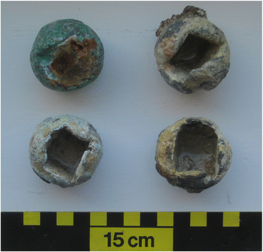
Composite shot
Some 975 intact and fragmented composite lead shot have been recovered from the site during the excavations, making it the single most common item of the finds assemblage. All the shot were measured in the field, while the 23 specimens recovered in 1998 were conserved at York Archaeological Trust (YAT) and underwent additional analysis. The shot range in diameter from 28 to 62 mm, but fall into four main size groups: 28–39 mm, 40–45 mm (>80% of the total number), 50–56 mm and 59–62 mm. In comparison, the 235 composite shot recovered from the Mary Rose ranged from 20 to 75 mm and fell into six comparable groups except for the largest size (Hildred, Citation2011: 348). The composite shot have iron dice cores that are covered in lead, similar to those recovered from other 16th‐century shipwrecks (Fig. 10), including Spanish wrecks at Highborn Cay (CitationSmith et al., 1985: 64), Molasses Reef (Keith et al., Citation1984: 55–6) and Padre Island (Arnold and Weddle, Citation1978: 250–1), a suspected Portuguese wreck in the Seychelles (Blake and Green, Citation1986: 11) and the Mary Rose (Hildred, Citation2011: 348).
Figure 10. Examples of the 40–42 mm composite lead shot, three with their iron dice cores missing. (Photo: D. Mearns)
In an attempt to determine the provenance of lead recovered from the site, 13 shot fragments, a sounding‐weight and a perforated disc were selected for elemental and lead isotope (LI) analysis. The lead content in each item was first confirmed by energy dispersive X‐ray fluorescence using an Olympus X‐5000. Small samples (∼1.5 mg) of clean metal were then taken from each artefact using a drill press while ensuring the metal was as ‘pure’ as possible and free of surface corrosion. The 15 samples were sent to Durham University for plasma sourced multi‐collector mass spectrometry (MC‐ICP‐MS), including thallium correction, conducted by Geoff Nowell. Zofia Stos‐Gale, former Director of the Isotrace Laboratory, University of Oxford, analysed and interpreted the raw LI data to determine the possible origins of the metal.
Provenancing of lead to determine the origin of archaeological artefacts is based on the direct comparison of their measured LI ratios (208Pb/206Pb, 207Pb/206Pb, 206Pb/204Pb) with available data from different mines around the world (Stos‐Gale and Gale, Citation2009; Cattin et al., Citation2009; Ling et al., Citation2014). The database used for interpretation in this study included over 6000 data sets from the Isotrace Laboratory, University of Oxford database (OXALID) and for lead and copper ores published by other researchers. The initial step involves finding ore samples that have identical (within ±0.1% of the error) values for all three LI ratios using the TestEuclid procedure described by Stos‐Gale and Gale (Citation2009). The measured LI ratios for the artefacts are then plotted on two mirror image LI diagrams, together with the data for all ore deposits that appeared to show matching LI ratios in the TestEuclid procedure (Fig. 11). The plots allow visual comparison of the mutual position of groups of analysed ores from various ore deposits relative to the LI ratios representing the artefacts. Finally, the geochemistry and chronological history of exploitation of the ore deposits is evaluated with respect to the supply of metal for these artefacts.
Figure 11. Three axes LI ratios for 15 samples of lead recovered from the site compared with lead ores from Spain, Portugal and England. (Z. Stos‐Gale)
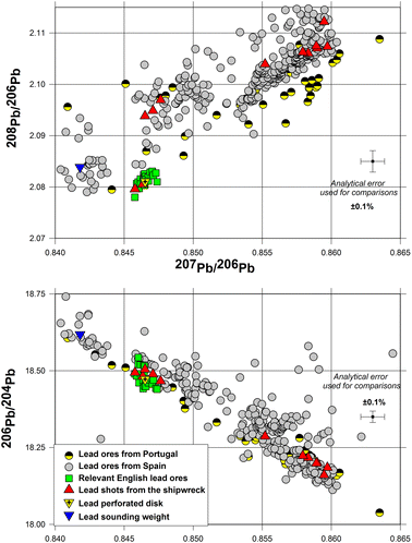
The LI ratios for each artefact and Stos‐Gale's interpretations for provenance are summarized in Table . The lead used in making the artefacts are consistent with ores from a number of different mining areas, each well known for extensive and mostly continuous exploitation of lead ores since prehistoric times and consistent with Portuguese trading patterns in the early 16th century. These sources include the large mine of Los Linares in south‐east Spain; mines in south‐west Spain (Ossa Morena, La Dehessa or Azuga in Estramadura); the Ossa Morena mine in Portugal; Pais Vasco in north‐west Spain, and British lead mines in Derbyshire and Somerset or Cheshire. At present there is much more published data for Spanish ores (about 1000) compared to Portugal (about 200), but, as the lead deposits and mines in the Ossa Morena cross the present‐day border, some of the ores collected in the Spanish part of these mountains can have the same LI composition as ores from the Portuguese side.
Table 2. Measured lead isotope ratios for sounding weight, perforated disc and 13 composite shot/fragments. Lead isotope analysis conducted by Geoff Nowell, Department of Earth Sciences, Durham University. Interpretation for provenance conducted by Zofia Stos‐Gale, former Director of the Isotrace Laboratory, University of Oxford, UK
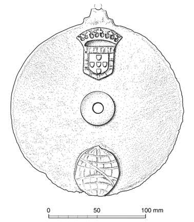
Copper‐alloy disc
During a metal‐detector search of gully Z a thin, copper‐alloy disc was found and recovered from beneath approximately 0.40 m of loose sand. The disc is 175 mm in diameter, 1.5 mm thick and has a hole of 10 mm formed by a raised central boss 32 mm in diameter (Fig. 12). At the top of the disc there appears to be a bracket, partially broken or corroded, suggesting the object was meant to be suspended. No writing or marks of any type were observed, nor were any other artefacts found near the disc to help explain its identity. The function of the disc is still unknown as no comparable object has been found in the literature. Its origin, however, is clearly and unmistakably Portuguese owing to the raised Portuguese royal coat of arms and the esfera armilar (armillary sphere) that adorn its upper surface. The armillary sphere, chosen by Manuel to be his personal emblem when he was the Duke of Beja before becoming king, is an iconic symbol of Portuguese navigation during the Age of Discovery. This important decoration indicates the disc was a high‐status object on board the ship.
Figure 12. 175 mm‐diameter copper‐alloy disc marked with the Portuguese royal coat of arms and esfera armilar. (Drawing: Lesley Collett)
Ship's bell
A small ship's bell was found in 2013 on the site in gulley Z lodged beneath a boulder at a depth of 4.3 m. The fragile bell is fractured in two pieces, its crown is missing leaving a rectangular hole on its top and a long vertical crack runs from the waist of the bell to the lip. Otherwise the bell is complete and in remarkably good condition considering its age and exposure in this high‐energy environment. The bell is simply decorated with a series of ten bead lines and has a raised inscription just below the shoulder containing letters and numerals that were barely visible beneath a layer of corrosion crust. Following conservation at YAT the intact bell had a total height of 195 mm and an external diameter at the mouth of 220 mm (Fig. 13). The elemental composition of the 3.74 kg bell, as determined by X‐ray fluorescence analysis, is: 48.58% tin, 30.46% copper, 7.62% antimony, 6.37% lead, 4.53% iron, with trace amounts of silver, bismuth, nickel and phosphorous.
Figure 13. Copper‐alloy ship's bell a) drawing (Lesley Collett); b) luminance lens image of letter ‘M’; c) luminance lens image of number ‘8’, images taken before conservation of the bell. (M. Abbott); d) CT scan image of date on the bell before conservation. (J. Warnett); e) photograph of date on the bell after conservation. (Cultural Heritage Digitisation Ltd)
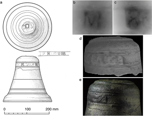
Prior to any conservation treatment the bell was scanned using both a structured‐light 3D scanning system (80 micron resolution) and a Nikon Metrology 320kV micro‐focus X‐ray (64 micron resolution) for computed tomography (CT). This non‐destructive high‐resolution imaging was performed to reveal minute detail in the raised inscription before any attempt was made by the conservator to remove the corrosive crust covering this part of the bell. The two scanning techniques were found to be complementary as the structured‐light illuminated mainly surface detail, while the powerful 320kV X‐ray source was able to penetrate the crust and reveal internal detail including additional characters. Before the scanning was conducted it was believed that the inscription contained an ‘M’ and an ‘8’ based on visual inspection alone. This was confirmed using the structured‐light technique and best visualized with an innovative processing technique called luminance lensing developed by Marcus Abbott of the YAT where the bell was conserved (Fig. 13b, c).
CT scanning of the bell was performed by Jason Warnett and Mark Williams at WMG, University of Warwick, before and after conservation. Multiple 3.5‐hour scan cycles, consisting of 3142 individual X‐ray projections, with different orientations of the bell were necessary to achieve optimum penetration while minimizing unwanted X‐ray scatter that would obscure characters in the inscription. Eventually, a ‘9’ and a less apparent ‘4’ were revealed to the left of the ‘8’ (Fig. 13d). Other than the apparent ‘M’ no other characters could be made out as the surface of the inscription was abraded smooth. Nevertheless, this non‐destructive imaging indicated that the inscription included a probable date (‘498’) that was at least chronologically correct with the known history of Sodré’s squadron, which had left Lisbon in 1502. Whether the ‘1’ in the date was simply abraded away, or omitted as was sometimes the practice in Portuguese writing from this period, is unknown. Importantly, the YAT conservator also benefited from having this information in advance to help guide physical removal of the corrosion crust. With the corrosion removed the characters revealed by the CT scanning became more visually apparent as can be seen in a high‐quality photograph (Fig. 13e).
Coins
Seven scattered gold coins and a concretion of gold and silver coins were found on the site. The gold coins are 12 Portuguese cruzados and a single Indian fanam. The scattered coins were found singly in locations beneath the excavated sediment either on top, or within crevasses of the bedrock. The cruzados were in excellent condition and only those found in the concreted mass required minimal treatment to remove some surface staining. The absence of other contexts associated with the coins suggests that they have been dispersed among the wreck remains and over time have worked their way through the loose sediment down to bedrock level.
The fanam is a very small, 8 mm‐diameter coin that was minted by various Indian states from the 12th to the 18th centuries, thus making it a poor tool for dating. The recovered fanam has been tentatively identified as a Vira Raya type issued by the Zamorinds of Calicut and mostly used on the Malabar Coast of India.
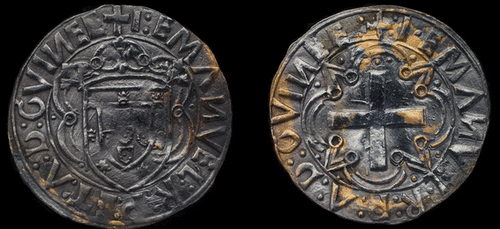
Of the 12 Portuguese cruzados, 11 were from the reign (1495–1521) of Dom Manuel I, along with a single specimen from the preceding reign (1481–1495) of Dom João II. During Manuel's 26‐year reign more than 2.7 million of the 3.55‐gram cruzados were minted in Lisbon (Trigueiros, Citation2014: 184). The Emanuel cruzados are considered to be a single numismatic type, with five sub‐types that quickly transitioned from sub‐type 1 in 1495 through to sub‐type 5, which was in regular production by the end of 1501 and kept without further change up to the end of Manuel's reign in 1521 (Trigueiros, A. pers. comm., unpublished report 27.09.2015). The Emanuel cruzados recovered from the site to date are a mixture of sub‐types 1 and 5 as per the Trigueiros typology (Trigueiros, A. pers. comm., Table , Fig. 14). According to the authoritative 6th Edition of Gomes’ catalogue of Portuguese coins, the João cruzado is a Gomes variety 23.09 (Gomes, Citation2013: 152).
Table 3. Classification of Portuguese cruzados according to António M. Trigueiros, Lisbon Geographical Society
Figure 14. a) Obverse of an Emanuel cruzado: Trigueiros sub‐type 5 initially minted in 1501. The dark colour of this gold coin is caused by a thin layer of silver plating deposited while the coin was bound within the clump of silver coins; b) reverse of an Emanuel cruzado. The absence of ‘ET’ in the reverse legend is a rarity. According to Trigueiros this coin is only the third known specimen. (Cultural Heritage Digitisation Ltd)
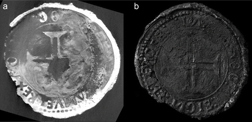
All the silver coins recovered from the site were found within a small, concreted mass that also included five of the cruzados described above. As silver coins from this period are better tools for dating than corresponding gold coins, the mass was brought to the UK to be conserved at YAT and for detailed examination. Initial X‐ray scans of the mass showed numerous silver coins arranged in three discreet coin blocks adhered to the row of five cruzados. The three blocks were mechanically separated from the cruzados following the application of 10% formic acid by pipette to the adhered surfaces. The silver coins contained within the three blocks were extremely fragile and seemed to lack metal cores. All silver content in these coins was lost and apparently re‐deposited as corrosion products between the coins and around the outside, encasing them. Overlying corrosion was removed by scalpel under magnification to fully reveal the surfaces of two silver coins welded together in one of the blocks, enabling their identification by visual means alone. After drying the powdery, fragile surfaces of the three blocks were consolidated with 5% Paraloid B72 in acetone.
The two silver coins that could be identified by visual examination were the Manuel índio minted in 1499, and the real grosso minted in the reign (1438–1481) of Dom Afonso V sometime between 1475 and 1479 (Gomes and Trigueiros, Citation1992: 9, 63; Gomes, Citation2013: 143, 161). The índio is an especially important and exciting discovery as it is a legendary coin ordered by Dom Manuel to be struck after the return of da Gama's first voyage to India. According to the chronicler Damião de Góis (Góis, Citation1567; Parte 4, Capitulo LXXXVI), in 1499 Dom Manuel ordered two new coins specifically for trade with India; a large gold coin equivalent to ten cruzados called the português (35.5 g) and a silver coin of the same weight of the Italian coins that were being used in the Indian trade (3 g, 26 mm), which was named índio: ‘The Indian’. The índio and the português are distinctive, almost unmistakable coins as they share virtually the same reverse engraving, which, for the first time for any Portuguese coin, included the cross of the Military Order of Christ and the legend IИ HOC SIGИO VIИCES: ‘in this sign you will conquer’. As Dom Manuel was already Grand Master of the Order of Christ before becoming king he adopted the cross as his personal insignia, thus endowing the índio and português with even greater significance and status (Gomes and Trigueiros, Citation1992: 92).
There is only one other known example of an índio coin in the world, which is held within the numismatic collection of the National Historical Museum (MHN) of Brazil in Rio de Janeiro (Trigueiros, Citation1996: 46; Museu Histórico Nacional, Citation2000). Despite the existence of the MHN specimen, the índio, because of its extreme rarity, has assumed legendary status within the numismatic community of Portugal as the ‘lost’ or ‘ghost’ coin of Dom Manuel I (Trigueiros A. pers. comm., unpublished report 25.6.2014). To ensure correct identification of the índio recovered from the site, the block within which it was contained was CT scanned at WMG, University of Warwick, using the 225kV head of the Nikon CT scanner, which provides 16‐micron resolution (Fig. 15). Even with such relatively poorly preserved coins the resulting scans, visualized in 3D using a VGStudioMax workstation, clearly revealed the same coat of arms and legend on the obverse matching the MHN specimen. It also matches the detailed description of the same coin that featured in an auction catalogue in Amsterdam in 1910, in which it was described as an unknown silver test of a cruzado (Schulman, Citation1910; lot 209, plate II) but later revealed to be the índio (Couvreur, Citation1952: 154). This same CT scan was also used to confirm the identification of the Dom Afonso V real grosso partially visible on the opposite side of this block as a Gomes type 38.03 owing to its deformed shield and the letters ‘P’ and ‘C’ occurring in the obverse and reverse sides, respectively (Gomes, Citation2013: 143), and a second real grosso and Manuel meio vintém that were sandwiched between the outer índio and real grosso coins.
Figure 15. a) CT scan image of the silver índio coin revealing the cross of the Military Order of Christ on the reverse and the word ‘REX’ in the obverse legend. (D. Mearns); b) photograph of the reverse of the silver índio coin after conservation. (Cultural Heritage Digitisation Ltd)
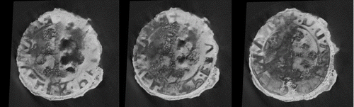
The extent of overlying corrosion of the other two coin blocks, containing three and 17 individual coins, respectively, was such that no coin surfaces could be seen. An attempt to separate the coins in the largest of the two blocks was terminated when it was clear that any further mechanical cleaning or chemical treatment could damage the coins causing information to be irretrievably lost. The only method for investigating the coins encapsulated within the blocks, therefore, was by the CT scanning described above. As a result of the dense and irregular stacking of the coins and their overall poor condition, visualization of the coin surfaces in the CT scans was difficult. João Pedro Vieira, Curator of Coins and Paper Money with the Bank of Portugal, assisted the analysis, which included the measurement of individual coin diameters, during examination of the CT scan images at WGM, University of Warwick. With some coins only a fraction of the legend was visible but this was sufficient to determine the sovereign, while the measured diameter helped distinguish the larger vinténs from the smaller meios vinténs. Nevertheless all the coins in these two blocks were identified as either meios vinténs or vinténs from the reigns of Manuel I or João II (Fig. 16).
Figure 16. Three CT scan images of an Emanuel meio vintém coin revealing the distinctive cross of the Order of Avis in the centre. (D. Mearns)
Conclusions
According to Castro and Fitzgerald there are ‘only approximately eighty known shipwrecks worldwide dating to the period of Iberia's maritime expansion in the early 16th century’ and of these ‘only a handful have been excavated by archaeologists’ (2006: 38). The opportunity, therefore, to scientifically study artefacts from one of the earliest Portuguese ships in the Carreira da India is a rare privilege that can result in unique discoveries about how maritime trade and warfare was conducted at the turn of this vital century, and provide tangible proof of historical accounts confined previously to the pages written by chroniclers long after the event took place. The wreck‐site of the naus Esmeralda and São Pedro, commanded by Vicente and Brás Sodré, might represent exactly this type of opportunity for nautical archaeology. In this interim report of a long‐running and ongoing project, we provide conclusive evidence, based on historical evidence combined with careful examination and scientific analysis of key artefacts, of the exact location where the ships wrecked and the identity of Vicente Sodré’s Esmeralda as the probable source of the remaining cultural material.
The bay where the site is located was almost a perfect geographical match for where the ships’ wrecked according to the descriptions of Pêro d'Ataíde and the chroniclers, especially the account of Corrêa. The accuracy of those accounts was instrumental in the relatively quick discovery of the site by a two‐man team in 1998. The remote nature of the site—on an island 45 km off the sparsely populated southern coast of Oman and within a bay only accessible by boat—explains the evident lack of disturbance we observed. When comparing the 1998 and 2013 surveys of stone shot exposed on the surface their positions were essentially unchanged. Unfortunately, significant infrastructure development on Al Hallaniyah, including a paved road directly to the bay, has changed that situation and the risk of unauthorized disturbance to the site is now considerable.
That artefacts were found in just the one set of interconnected gullies, and nowhere else, indicates that the site is the exact location where at least one of the ships was driven ashore and wrecked. The natural pattern in the bay is for swell to build just seaward of the site and for waves to break directly over the gullies. Moreover, the nearly total concentration of heavy iron shot, lead composite shot and the breech chambers found in an area approximately 5×6 m suggests they mark the position of the ship's armoury where the hull finally came to rest. Considering all our findings and observations, the likely wrecking scenario is that after their moorings parted the ships were driven against the lee shore, with at least one being funnelled into the mouth of the gullies by the natural pattern of swell and breaking waves. As this ship was driven into the gullies its bottom would have most probably hit the reef between gulley X and gulley Z at only 2.1–1.0 m depth, causing fatal damage to the hull before it was driven further ashore. Once stranded in this position the ship would have been at the mercy of the sea and ultimately broken apart with little hope for the men aboard.
It seems unlikely that the artefacts found represent the remains of more than one of the ships. The historical accounts and sole illustration of the wrecking in Livro das Armadas tells a story of Brás’ ship São Pedro being driven onshore whereby his men could escape via the rigging, whereas Vicente's ship Esmeralda was lost in the sea causing his death and that of his men. Contemporaneous salvage by the Portuguese, and later by Malik Ayaz, undoubtedly explains why more artefacts—and certainly no heavy guns—have been found. Given that the Portuguese set fire to what remained of the wreckage, and the poor conditions for preservation, it is equally unsurprising that no timbers have survived the passing of 510 years in this high‐energy environment. Nevertheless, the artefacts that were found clearly point to a heavily armed Portuguese ship consistent with a 1502 departure from Lisbon.
The artefacts that most directly confirm the nationality and date of the wreckage are: 1) the copper‐alloy disc with the Portuguese royal coat of arms and Emanuel esfera armilar; 2) the ship's bell carrying the inscription ‘498’; 3) the Emanuel cruzados that were all in regular production before the end of 1501; and, most importantly, 4) the silver índio: created in 1499 and in production for a very limited period before being discontinued and replaced by the heavier tostão no later than 1504 (Gomes and Trigueiros, Citation1992: 105). The extreme rarity of the silver índio, as only the second known specimen in the world, and the fact it was used specifically for Portuguese trade in India, is by itself a strong indicator of the ship's nationality. Moreover, that none of the 24 silver coins found on the site were from the 1504 tostão series of coins suggests a possible terminus ante quem for the date the ship was wrecked.
The evidence presented herein indicates the site is that of the wreck of an Iberian ship of the early 16th century. The artefact assemblage provides very strong links with Portugal as being the vessel's country of origin. Given the extreme rarity of European shipping in these waters at this date and the clear geographical correlation between the site and the historical record of the loss of the Sodré ships, it is difficult to believe that the site can be anything but the wreck of either the São Pedro or Esmeralda. Indeed, the relatively well‐documented history of Portuguese shipwrecks includes no other losses anywhere near the Al Hallaniyat Islands.
Although the historical record suggests the wreckage, if it is indeed from just one ship, is from Vicente's Esmeralda and not the São Pedro, we still lack conclusive proof to make this determination. A possible clue does exist, however, in the ‘VS’ mark carved in each of the 35 large igneous shot recovered. The possibility the ‘VS’ is an abbreviation for Vicente Sodré, and that the stonecutter marked the shot to designate them for a specific gun on board Esmeralda must be considered. Given his separate regimento from Dom Manuel and the overall military mission of his squadron, it is reasonable to expect that Vicente Sodré’s ship was one of the most heavily armed in the fleet and that he had prepared his ship accordingly. The question remains whether ‘VS’ is an owner's mark for Vicente Sodré. Although these markings are highly exceptional, the example of the iron shot marked ‘H’ and thus identifying King Henry VIII as owner of the Mary Rose shows this is not a unique occurrence.
Acknowledgments
Funding for this project has been provided by Oman's Ministry of Heritage and Culture and by grants from National Geographic Society Expeditions Council and the Waitt Foundation made to David Mearns, and would not have been possible without the enthusiastic support of H. E. Salim Al‐Mahruqi and H. E. Hassan Al‐Lawati. Zofia Stos‐Gale, João P. Vieira, António M. Trigueiros, Fredrik Hiebert, Christopher Thornton, Alexzandra Hildred, Jay Warnett, Mark Williams, Ana P. Jesus, Luisa Ribeiro, Miguel M. Ramalho, José Piçarra, Tânia M. Casimiro, Andrew Carter and Geoff Nowell have all made valuable contributions to this study. We are grateful to our archaeologists and divers for the excellent work in the field: Ayyoub Al‐Busaidi, Ahmed Al‐Siyabi, Sultan Al‐Maqbali, Ali Al‐Tah, Mashal Al‐Shaaily, Ali Al‐Zahli, Alex Double, Thomas Cousins, Grant Bettinson, Daniel Pascoe, Jessica Berry, Kevin Stratford, Peter Holt, Mark Trowell, Ryan Murray, Heather Stewart, Katherine Dance and Kristin Romey.
Notes
1. During the period this paper was under review another extensive excavation of the site was conducted in late 2015 and more than 800 additional artefacts were recovered, the bulk of which were ceramic sherds. The total assemblage of artefacts, now numbering over 2800, will be subjected to future archaeological study and assessment. However, no artefact or information learned from the latest excavation changes or alters the conclusions of this interim report.
References
- Arnold, J. B., III and Weddle, R. S., 1978, The nautical archaeology of Padre Island: The Spanish shipwrecks of 1554. New York.
- ANTT‐CC, 1508, Arquivo Nacional de Torre do Tombo, Corpo Chronológico, dated 10 September 1508, Parte III, Maço 3, No. 54.
- Ataíde, Pêro d’ 1504, Carta de Pero de Atayde a El‐rei D. Manuel, Fevereiro 20, 1504, ANTT, Corpo Chronológico, Parte I, Maço 4, No. 57.
- Barros, J., 1552, Ásia de João de Barros: Dos feitos, que os Portuguezes fizeram no descubrimento, e conquista, dos mares, e terras do Oriente. Decada I, Livro VII, Capitulo II.
- Berthou, P. Y., 1973, Le Cénomanien de l'Estrémadure portugaise. Memórias dos Serviços Geológicos, Portugal 23, 1–168.
- Blake, W. and Green, J., 1986, A mid‐XVI century Portuguese wreck in the Seychelles. IJNA 15.1, 1–23.
- Canilho, M. H., 1990, Elementos de geoquímica de rochas do Maciço Igneo de Sines. Ciências da Terra 10, 65–81.
- Castanheda, F. L., 1582 (trans.)(1st edn 1551–1560), História do descobrimento & conquista da Índia pelos portugueses, Livro I, Capitulo LIV.
- Castro, F. V., 2005, The Pepper Wreck: A Portuguese Indiaman at the Mouth of the Tagus River. College Station, TX.
- Castro, F. V. and Fitzgerald, C., 2006, The Playa Damas Shipwreck: An Early Sixteenth‐Century Shipwreck in Panama, in Underwater Cultural Heritage at Risk. ICOMOS, Paris.
- Cattin, F., Guénette‐beck, B., Besse, M. and Serneels, V., 2009, Lead isotopes and archaeometallurgy. Archaeological and Anthropological Sciences 1.3, 137–48.
- Chirikure, S., Sinamai, S., Goagoses, E., Mubusisi, M. and Ndoro, W., 2010, Maritime Archaeology and Trans‐Oceanic Trade: A Case Study of the Oranjemund Shipwreck Cargo, Namibia. Journal of Maritime Archaeology 5.1, 37–55.
- Corrêa, G., 1858 (written c.1550s), Lendas da Índia, Livro I, Capitulo VI. Lisbon: Academia Real de Sciencias.
- Couvreur, R. C., 1952, Moedas de D. Manuel I. O Índio Revista de Guimarães 62, 152–59.
- Góis, D., 1567, Chrónica do Felicíssimo Rei Dom Emanuel, Parte 1, Capitulo LXXIV; Parte 4, Capitulo LXXXVI. Lisbon
- Gomes, A., 2013 (6th edn), Moedas Portuguesas. Lisbon.
- Gomes, A. and Trigueiros, A. M., 1992, Portuguese coins in the age of Discovery 1385–1580. Lisbon.
- Gregory, D., 2006, Mapping navigational hazards as areas of maritime archaeological potential: the effects of sediment type on the preservation of marine archaeological remains. Report from the Department of Conservation, National Museum of Denmark.
- Guinote, F., Frutuoso, E. and Lopes, A., 1998, Naufrágios e outras perdas da carreira da India. Grupo de Trabalho do Ministério da Educaão para as Comemorações dos Descobrimentos Portugueses, Lisbon.
- Henriques, S. B., Neiva, A. R., Riveiro, M. L., Dunning, G. R. and Tajčmanová, L., 2015, Evolution of a Neoproterozoic suture in the Iberian Massif, Central Portugal: New U‐Pb ages of igneous and metamorphic events at the contact between the Ossa Morena Zone and Central Iberian Zone. Lithos 220–223, 43–59.
- Hildred, A., (ed.) 2011, Weapons of Warre: the armaments of the Mary Rose. Portsmouth.
- Hulton, J. G., 1840, Notice on the Curia Muria Islands. Transactions of the Bombay Geographical Society III, 183–97.
- Keith, D. H., Duff, J. A., James, S. R., Oertling, T. J. and Simmons, J. J., 1984, The Molasses Reef Wreck, Turks and Caicos Islands, B.W.I.: a preliminary report. IJNA 13.1, 45–63.
- Museu Histórico Nacional, Departamento de Numismática, 2000, Moedas Portuguesas da Época dos Descobrimentos na Colecção do Museu Histórico Nacional 1383–1583. Rio de Janeiro.
- Ling, J., Stos‐gale, Z. A., Grandin, L., Billström, K., Hjärthner‐holdar, E. and Persson, P. O., 2014, Moving metals II: provenancing Scandinavian Bronze Age artefacts by lead isotope and elemental analyses. Journal of Archaeological Science 41, 106–32.
- Livro das Armadas da Índia, 1497–1640. Manuscript in the Arquivo Nacional Torre de Tombo.
- Livro das Armadas da Índia, c.1568, Memória das Armadas que de Portugal passaram à Índia esta primeira é a com que Vasco da Gama partiu ao descobrimento dela por mandado de El‐Rei Dom Manuel no segundo ano de seu reinado e no do nascimento de Cristo de 1497. Manuscript in the Academia de Ciências de Lisboa.
- Pearson, M. N., 1976, Merchants and Rulers in Gujarat. Berkeley, CA.
- Schulman, J., 1910, Collection de feu le Dr. Jules Meili à Zurich: primiére partie: monnaies portugaises continentals, colonials, des Indes portugaises. Amsterdam.
- Smith, R. C., Keith, D. H. and Lakey, D., 1985, The Highborn Cay wreck: Further exploration of a 16th‐century Bahamian shipwreck. IJNA 14.1, 63–72.
- Stos‐gale, Z. A. and Gale, N. H., 2009, Metal provenancing using isotopes and the Oxford archaeological lead isotope database (OXALID). Archaeological and Anthropological Sciences 1.3, 195–213.
- Subrahmanyam, S., 1997, The career and legend of Vasco da Gama. Cambridge.
- Trigueiros, A. M., 1996, Apareceu O ‘Índio’ de D. Manuel I. Moeda, 21.2, 55–9.
- Trigueiros, A. M., 2014, Nach Portugalis—Parte XII: Estatísticas das amoedações dos Portugueses de ouro, 1500–1538. Moeda 39.4, 179–92.
- UK Hydrographic Department, 1987 (12th edn), Red Sea and Gulf of Aden Pilot. Taunton.
- Walker, W., Dunham, R., Hildred, A. and Rule, M., 1989, Analytical study of composite shot from the Mary Rose. Journal of the Historical Metallurgy Society 23.2, 84–90.
- Walter, J., 1994, The Kaiser's Pirates: German Surface Raiders in World War One. London.