Abstract
Soil salinization is a serious problem in the arid and semi-arid regions of Central Asia. To address the problems, we analyzed the dynamics and distribution patterns of salts in both rice-based and cotton-based cropping fields in selected farms of southern Kazakhstan and Uzbekistan with special emphasis on the dynamics of gypsum, which had a lower solubility than Na salts, as an index of water-movement regimes in irrigated fields. Most of the rice-based plots and some of the cotton-based plots exhibited no surface accumulation of soluble salts or gypsum because of repeated washing by a huge amount of irrigation water in the former or comfortable drainage in the latter. These soils are probably free from the risk of secondary salinization under present conditions and management practices. In contrast, uncultivated plots near canals accumulate both soluble salts and gypsum in the surface soil layers, and these salts would not be leached out without a drastic change to a predominantly downward pattern of water movement. In the intermediate stages in terms of soil salinization, some soils accumulated substantial amounts of soluble salts in surface layers but relatively low amounts of gypsum. In this case, periodic irrigation could have washed out most of the gypsum and soluble salts in a downward direction and, consequently, it is possible to leach out the accumulated soluble salts by applying additional irrigation water if necessary. However, there were some cases in which soils accumulated large amounts of gypsum in surface layers as well as soluble salts, suggesting that irrigation/drainage is generally insufficient to remove gypsum with a lower solubility and that these profiles are dominated by an overall upward movement of water. For these soils, drainage facilities should be improved to ensure the efficient leaching of accumulated salts on cropping. Thus, the condition of irrigated plots in terms of the direction of water movement and resulting salt regimes can be well understood from the distribution patterns of both soluble salts (or cations) and gypsum.
INTRODUCTION
Salt-affected soils in North and Central Asia cover more than 200 million hectares, which corresponds to approximately 20% of the total global area of such soils (CitationSzabolcs 1986). In the former Soviet Union, many large-scale irrigation projects associated with rice-based and cotton-based agriculture were established in arid regions of Central Asia from the 1960s. The total area of irrigated fields in Central Asia amounted to 7.86 million hectares in 1980, of which 1.93 million hectares were in Kazakhstan (CitationDukhovny 1985); this enhanced the process of soil salinization in farms of this area. According to CitationRozanov (1984), approximately 1 million hectares of land in Central Asia were already lost because of unsuitable irrigation practices. CitationKhakimov (1989) stated that the proportion of moderately to severely salinized soils in irrigated areas of Kazakhstan reached 60–70%, and that crop yields decreased by 30–33%. The development of irrigation agriculture also resulted in a drastic decrease in water level in the Aral Sea, accompanied by an increase in salt concentrations. Pollution of surface water and/or groundwater by various salts and agricultural chemicals has led to environmental and human health concerns (CitationIshida et al. 1995; CitationMainguet 1991; CitationWilliams and Aladin 1991). Following the collapse of the Soviet Union in 1991, the economic basis that had ensured the development of irrigation agriculture was largely lost, resulting in further difficulties in maintaining agricultural systems because of economic problems and the environmental problems described above. It is therefore necessary to reorganize the agricultural systems in these regions to address recent political and environmental changes and to ensure that the enterprises are profitable and ecologically sound.
Global population pressure will lead to increasing reclamation of marginal lands for agricultural use. This situation occurs in semi-arid zones that face potential saline hazards. For example, large-scale development programs are currently being undertaken in the Xinjiang–Uyghur region of China. Given that extensive reclamation programs may be unavoidable, the merits and pitfalls of irrigation agriculture, as experienced in the former Soviet Union, should be shared and utilized to ensure sustainable development in other countries.
The problems that accompany soil salinization can be primarily attributed to the redistribution of water and salts in arid environments as a result of inappropriate water management practices. To address these problems, it is essential to analyze the dynamics of water and salts and to formulate proper guidelines for salinity control to promote agricultural development under large-scale irrigation systems. Our objective in the present study is to analyze the dynamics and distribution patterns of salts in both rice-based and cotton-based cropping fields in selected farms of southern Kazakhstan and Uzbekistan. We placed special emphasis on the dynamics of gypsum, which had a lower solubility than Na salts (Ksp = 2.3 × 10⁻⁵ for CaSO4; cited from CitationChemical Society of Japan 1975), as an index of water-movement regimes in irrigated fields.
MATERIALS AND METHODS
Survey sites
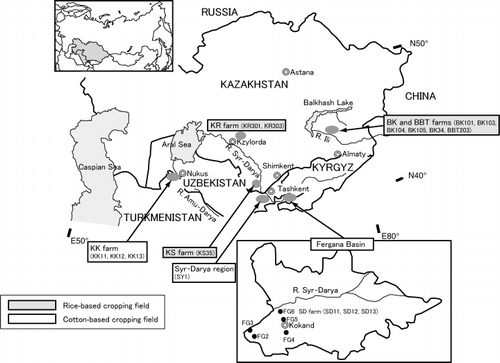
For analysis in the present study, we selected irrigated farms with varying conditions in terms of water source (or quality) and location from the watersheds of the Ili, Syr-Darya and Amu-Darya Rivers in southern Kazakhstan and Uzbekistan (; ). Most of the study sites were derived from recent alluvial deposits except for the Syr-Darya irrigated region, which was located in relatively high terrain against the Syr-Darya River and was significantly affected by loess deposit. Soils distributed in the study sites were primarily Calcisols and partially Solonchaks according to World Reference Base for Soil Sciences (WRB) (CitationFood and Agriculture Organization et al. 1998). Precipitation was usually less than 200 mm with a maximum rainfall during winter to springtime. A brief description of the respective study sites and sampling design is provided below.
Irrigated farms under a rice-based cropping system
BK farm is located 250 km north of Almaty, the former capital of Kazakhstan, within the floodplain of the Ili River. The mean annual precipitation in this area is 150 mm, with an average air temperature of 9°C. The farm was established in 1979 and practices a 4-year rice-based crop rotation system; that is: rice, rice, barley with alfalfa, and finally alfalfa. The adjacent BBT farm experiences similar climatic conditions to those of the
Table 1 Outline of the soil sampling plots
Figure 1 Locations of the sample sites.
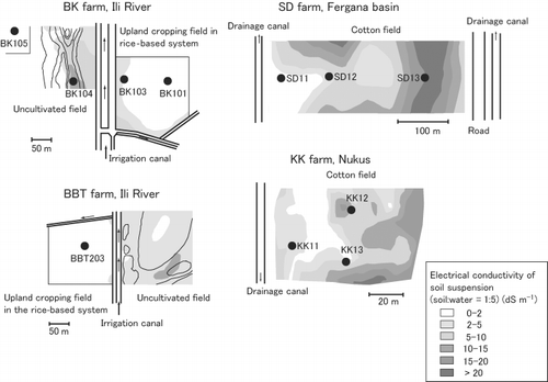
To investigate spatial variability in soil salinity within these farms, we collected 21–29 soil samples from each farm from the surface layer of both cultivated fields and adjacent uncultivated fields. Samples were collected at 25-m intervals along four transects spaced at 50-m intervals. In the cropping fields of the BK farm, barley and alfalfa were being cultivated at the time of soil sampling in 1992 (the first year of the upland cropping phase), while at the BBT farm cropped field alfalfa was planted in the third year of upland cropping at the time of soil sampling in 1993. To analyze the dynamics of salt species in the soil profiles of these farms, soil samples were also collected from representative profiles (BK101, BK103, BK34 and BBT203 in cropped fields, BK104 in the adjacent uncultivated field affected by irrigation, and BK105 in semi-natural condition) (see ).
KS farm is located in the middle part of the Syr-Darya River at an elevation of approximately 200 m a.s.l., approximately 170 km southwest of Shimkent near the border with the Republic of Uzbekistan. Mean annual precipitation is 250 mm and the average air temperature is 14°C. The farm was established in 1960, and rice is cultivated for 3 years within a 6-year crop rotation. Soil samples were collected in 1994 from a representative plot, KS35, from different layers within the soil profile.
KR farm is located approximately 20 km east of Kzylorda within the floodplain of the Syr-Darya River. The farm was established in the 1960s and typically has a 7-year, rice-based crop rotation system of rice, rice, rice, maize, wheat with alfalfa, alfalfa, and finally alfalfa. The mean annual precipitation is approximately 150 mm and the average air temperature is 10°C. In 1995, we collected soil samples from different soil layers from representative profiles (i.e. KR301 in a rice-based cropping field and KR303 in an adjacent uncultivated field).
More than 3000 mm of irrigation water is applied for rice cultivation in these farms, whereas the upland crops are generally cultivated by making use of high groundwater levels. Detailed experimental results for these rice-based farms (i.e. BK, BBT, KS and KR) have been published previously (CitationFunakawa et al. 2000).
Irrigated farms under a cotton-based cropping system
Fergana Basin, Uzbekistan, is one of the most famous regions in the world in terms of cotton cultivation, and is believed to have produced cotton for several centuries. The basin is located in the middle to upper reaches of the Syr-Darya River. Annual precipitation in this area is approximately 150 mm and the average air temperature is 16°C. The Syr-Darya River crosses the northern part of the basin from east to west, and the southern plain of the river is used for intensive irrigation agriculture. In 1996 we collected soil samples in this area from selected profiles at different locations from the Syr-Darya River (i.e. samples FG2, FG4 and FG5 were collected from high terrain far from the river and samples FG3 and FG6 were collected from sites close to the river).
In 1997 we collected a total of 27 surface soil samples from SD farm, close to site FG6, to investigate spatial variation in salt accumulation in the surface layers of soil in the same manner as that undertaken for the rice-based fields at BK farm and BBT farm. Representative plots for profile sampling were selected at SD11, SD12 and SD13 in SD farm.
The Syr-Darya irrigated region is located in the middle sections of the Syr-Darya River. The region is irrigated from a long canal that runs from the Syr-Darya River and, hence, suffers frequent water shortages. One representative profile (SY1) was selected for analysis in 1996. The climatic conditions of this area are similar to those of KS farm.
Nukus City is located in the lowermost floodplain of the Amu-Darya River and is, hence, subjected to environmental problems associated with irrigation agriculture. In this region, we collected a total of 60 surface soil samples in 1997 from KK farm, located near Nukus City, to investigate spatial variability in soil salinity within cropped fields. At the same time, soils were sampled from representative profiles in terms of salt distribution at sites KK11, KK12 and KK13.
In the areas of Fergana, Syr-Darya and Nukus, upland crops including cotton are usually planted continuously. The amount of irrigation water recommended for cotton cultivation is approximately 800 mm per year; however, in the lower tributaries of the irrigation network, such as the KK series and SY1, water supply is often insufficient because of annual fluctuations in the amount of water available from the river.
Water samples were also collected from irrigation and drainage canals in each farm or region to analyze the general condition of irrigation agriculture in terms of the quality of irrigation water and drainage water.
Analytical methods
The collected soil samples were air-dried and passed through a 2-mm mesh sieve in preparation for analysis of electrical conductivity (EC) (using a soil : water ratio of 1:5), contents of water-soluble cations (using saturation paste), gypsum content and particle size distribution.
The soil : water ratio of water extraction largely determines the amount and composition of soluble salts (e.g. CitationGupta and Abrol 1990). As with our previous research (CitationFunakawa et al. 2000), we used an extraction ratio of 1:5 to determine the EC value, which reflected total water-soluble salts including CaSO4 to a greater extent, for analyzing spatial variability in soil salinity within farms, as well as the ratio of saturation paste to analyze the salinization process associated with water dynamics in soil profiles under field conditions.
The concentrations of Na+, K+, Mg2+ and Ca2+ in the extracts were determined using atomic absorption spectrophotometry (AAS) (AA640–01, Shimadzu, Kyoto, Japan). Soil texture was determined using a combination of a pipette method and sieving following pretreatment with acetate buffer at pH 5.0 to remove carbonates (CitationSoil Survey Laboratory Staff 1992). Gypsum content was determined indirectly based on the amounts of Ca2+ (determined by AAS) and SO2− 4 (determined by high-performance liquid chromatography [HPLC][LC3A, Shimadzu, Kyoto, Japan]) extracted at varying soil : solution ratios (method code 6F1b in Soil Survey Laboratory Methods Manual of USDA [CitationSoil Survey Laboratory Staff 1992]; CitationLagerwerff et al. 1965; CitationLoeppert and Suarez 1996). This procedure is roughly described as follows:
where (SO4)DE = SO4 in dilute water extract with a sufficiently high soil : water ratio to dissolve gypsum (i.e. 1:200), (SO4)SE = SO4 in saturation extract, and
According to a preliminary experiment to determine the gypsum content semiquantitatively, we used a soil : water ratio of 1:200 for complete dissolution of sulfates in the dilute extraction.
Collected water samples were analyzed for EC and the concentration of each component. The Na+, K+, Mg2+ and Ca2+ contents of the extracts were determined using AAS, whereas Cl−, NO− 3 and SO2− 4 contents were analyzed using HPLC. The contents of carbonaceous species were determined using a total organic carbon analyzer (TOC) (Shimadzu, TOC−5000), and the concentrations
Figure 2 Distribution of salts in the surface layers of soils in and around the irrigated fields.
RESULTS AND DISCUSSION
Chemical composition of irrigation and drainage water
provides the chemical composition of water sampled from the irrigation and drainage canals at the study sites. Although the water samples were collected in different years, yearly fluctuation in the chemical composition is believed to be rather small, for example, 8.29 (1993) and 8.19 (1994) for pH and 0.61 dS m−1 (1993) and 0.60 dS m−1 (1994) for EC of the irrigation water in BK (data in 1993 are cited from CitationFunakawa et al. 1995). Both the EC and sodium adsorption ratio (SAR; Na/[Mg + Ca] in [mmol L−1]1/2) are higher in irrigation water from Syr-Darya and Amu-Darya Rivers than that from Ili River or small tributaries of Syr-Darya River in the Fergana region. According to the criteria used to evaluate the quality of irrigation water based on EC and SAR (CitationUS Salinity Laboratory Staff 1953), irrigation water from BK farm is classified as C2–S1, while water from farms KS, KR and KK and the Syr-Darya region is C3–S1. The higher terrain of the Fergana region (FG4 and FG5) receives high-quality irrigation water from the Soh River (C2–S1), while water quality is worse in the remaining area that is directly irrigated from the Syr-Darya River (C3–S1). Thus, farms in the Syr-Darya and Amu-Darya basins, excluding the higher terrain of the Fergana Basin, have a greater potential for soil salinization resulting from the addition of salts from irrigation water than those farms along the Ili River.
Higher salt concentrations in drainage water than in irrigation water at each farm indicate that reasonably high amounts of soluble salts within the soils were washed out via leaching by the applied water.
Spatial variability in soil salinity within farms under irrigation agriculture
To analyze spatial variability in soil salinity within farms under irrigation agriculture, a contour plot of the
Table 2 Chemical composition of samples of irrigation and drainage water
Under cotton-based agriculture, the amount of salts accumulated in surface soils was generally much higher than under rice-based systems. Fields that are distant from drainage canals are, in particular, more extensively affected by soil salinization. The effective range of drainage canals appears to differ for SD and KK, presumably because of factors related to, for instance, the groundwater table and soil texture. For example, the cropping field within the SD farm in the Fergana Basin appears to have an effective drainage range of up to 100–200 m from the drainage canal on the left side (as the drainage canal on the right side does not seem to operate well in that field because of the constructed road between the field and the canal), while in the KK farm of Nukus the range is < 100 m. Although the factors that determine the effective range of drainage canals are unclear, it is important to establish and maintain appropriate drainage systems to successfully develop cotton-based irrigation agriculture.
Soil salinization observed in the rice-based crop rotation systems
According to our previous report on rice-based cropping systems (CitationFunakawa et al. 2000), soil salinization begins following the termination of rice cultivation, continues throughout the first year of the upland phase under a relatively high water table, and progresses more gradually during the second year. At BK farm, the annual rate of salt accumulation during the first year of the upland phase is roughly estimated to be 45 kmolc ha−1 year−1, with a predominance of sulfates of Ca2+, Mg2+ and Na+ as the salt components. During the second year, accumulation totaled 15 kmolc ha−1 year−1, with a predominance of Na+ and Cl− salts.
shows the distribution patterns of water-soluble cations and SAR determined for saturation extract, gypsum content and soil texture in the representative soil profiles of both the upland cropping and uncultivated plots at BK, BBT, KS and KR under rice-based cropping systems. Gypsum and/or soluble salts usually accumulate at or near the soil surface, with a concomitant increase in SAR, although the amounts are generally low in cultivated plots. In uncultivated plots that are affected by irrigation (BK104 and KR303), soil salinity is commonly much higher than in cropped plots, presumably because of the cumulative effect of soil salinization. Judging from the fact that the semi-natural soil at BK105 does not exhibit such trends and that in irrigated fields the water table is usually maintained as shallow as 1 m, the salt-bearing water moved upward because of intensive evapotranspiration under irrigation, resulting in the accumulation of gypsum and/or soluble salts at or near the soil surface in these plots.
Soil salinization observed in cotton-based crop rotation systems
shows the distribution patterns of water-soluble cations and SAR determined for saturation extract, gypsum content and soil texture in soil profiles from cotton-based cropping fields. In the Fergana region, at higher terrains relative to the Syr-Darya River (FG2, FG4 and FG5), only minor soluble salts and gypsum accumulate in the upper layers of the soil profile. The high quality of the irrigation water from the Soh River, a tributary of the Syr-Darya River (see ), may be one of the factors that provides favorable conditions for these plots. The relatively light texture of the soils and appropriate drainage conditions may also ensure adequate leaching of soluble salts from the surface layers. Nonetheless, high concentrations of gypsum were commonly detected in the deeper layers of soils with heavier texture at SD11, SD12, FG5 and FG6. This indicates that the amount and/or effect of irrigation water in terms of leaching is not as intensive as under the rice-based systems, even though surface leaching is comfortable. A similar situation is also observed at SY1, in relatively high and flat terrain subjected to water shortages, where gypsum appears to be leached only from the surface soils and remains undisturbed in the subsoils.
Figure 3 Distribution pattern of water-soluble cations and gypsum in soil profiles subjected to rice-based irrigation systems. SAR, sodium adsorption ratio.
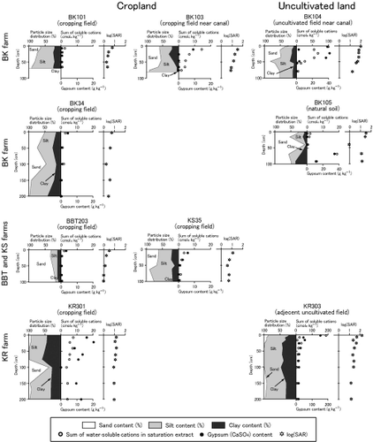
Figure 4 Distribution pattern of water-soluble cations and gypsum in soil profiles subjected to cotton-based irrigation systems. SAR, sodium adsorption ratio.
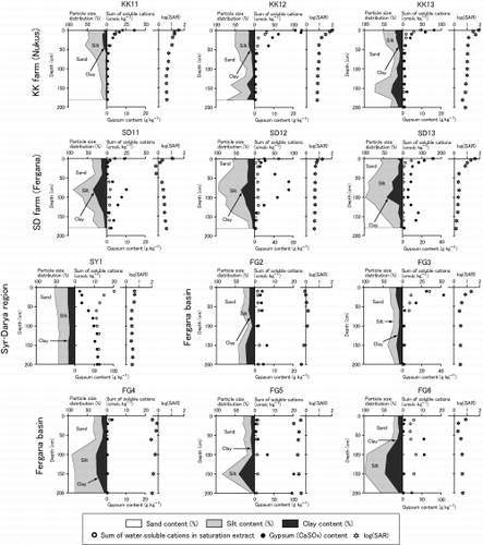
In contrast, some soils located near the Syr-Darya River in the Fergana region record an accumulation of gypsum and soluble salts with a concomitant increase in SAR in surface layers (e.g. SD13 and FG3). This may represent a secondary salinization resulting from incomplete drainage or rising groundwater levels induced by serious economic degradation over recent years. It is estimated that in the absence of leaching, approximately 10 kmolc ha−1 year−1 of soluble salts accumulates in soil profiles with the application of 800 mm of irrigation water from the Syr-Darya River. Without adequate drainage, this would lead to serious soil salinization. Such a trend is also conspicuous in the KK soils at Nukus, which is located on the floodplain of the Amu-Darya River. Gypsum was present only in the surface layers, with a concomitant increasing trend in soluble salts and SAR, as was observed in the rice-based field during the upland cropping phase with high groundwater levels. This indicates a continuous increase in water levels in these fields.
In summary, the Fergana region is generally suitable for agricultural management in terms of the movement of water and salts, although in some locations the upward movement of water and soluble salts is predominant. In contrast, KK farm has serious difficulties, which are related to its location on the lower floodplain and the occurrence of occasional water shortages.
Dynamics of soluble salts and gypsum in irrigated fields of contrasting water regimes
To compare the distribution patterns of soluble salts and gypsum in different soil profiles, we calculated the concentrations of water-soluble cations (or gypsum) in the uppermost 50 cm and 50–150 cm layers of soils on the basis of hectares in acreage and soil depth (). The depth of 50 cm was chosen because the surface accumulation of soluble salts or gypsum, if any, was mostly observed in the upper 50 cm soil layers.
shows that for all the plots in rice-based fields and adjacent uncultivated fields affected by irrigation, soluble cations accumulate to a greater degree in the surface layers of the soil. The amount of cations in the surface is, however, much greater in uncultivated fields than in cultivated fields because of the cumulative effect of rising groundwater. The rice-based field is washed out repeatedly during the rice-cultivation phase
Figure 5 Degree of surface accumulation of (a) soluble cations and (b) gypsum and (c) comparison of them in soils under different land uses. Soils were arbitrarily classified into four groups, I, II, III, IV, based on the abundance of soluble cations and gypsum in (c).
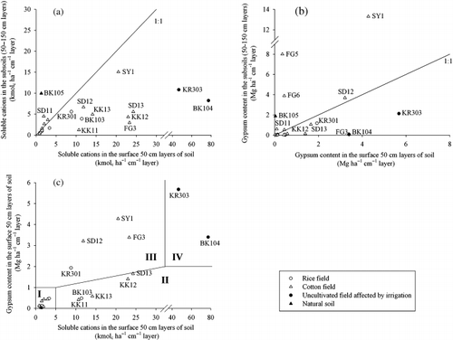
shows the accumulation of gypsum in the surface and subsoils. In most of the plots for rice-based fields (except KR301), gypsum is barely detected in either the surface or subsoils. Repeated leaching during the irrigated paddy phase may have dissolved and removed gypsum from the soil profiles, if it initially existed to a great degree. The data also suggest that KR301 in the Kzylorda region was subjected to incomplete drainage during the paddy phase and that the situation in this area appears to be worse than in other rice-cultivated areas. As some of the plots in the cotton fields (e.g. FG3, SD13 and KK12) accumulated substantial amounts of gypsum in the surface soil layers, as with uncultivated plots located close to paddy fields (BK104 and KR303), the plots appear to record the cumulative effect of the upward movement of water and accompanying soluble salts.
In contrast, cotton plots such as FG5, FG6 and SY1, in which greater amounts of gypsum are present in deeper soil layers, are moderately well-drained from surface layers. For FG5 and FG6, only minimal amounts of soluble salts were detected in the surface layers, as with the majority of cotton plots (FG2, FG4 and SD11); this indicates that the overall direction of water in these plots is downward.
The potential risk of salinization or the possibility of amelioration of salinized soils is more clearly depicted in , which shows the amounts of soluble salts and gypsum accumulated in the uppermost 50 cm of the soil profiles. We then arbitrarily classified the soils into four groups based on the abundance of soluble cations and gypsum. Most of the rice-based plots and some of the cotton plots fall into Category I, in which no surface accumulation of soluble salts or gypsum is observed. These soils are probably free from the risk of secondary salinization under present conditions and management practices. In contrast, uncultivated plots accumulate both soluble cations and gypsum in the surface soil layers (Category IV), and these salts would not be leached out without a drastic change to a predominantly downward pattern of water movement. Category II soils accumulated substantial amounts of soluble salts in surface layers, but relatively low amounts of gypsum. In this case, the overall direction of water movement is not always upward, and periodic irrigation could have washed out most of the soluble salts and gypsum in a downward direction, although the soluble salts easily re-accumulated after leaching. Consequently, it is possible to leach out the accumulated soluble salts by applying additional irrigation water, if necessary. Category III soils accumulated large amounts of gypsum in surface layers as well as soluble cations, suggesting that irrigation/drainage in this case is generally insufficient to remove moderately soluble gypsum and that these profiles are dominated by an overall upward movement of water. For these soils, drainage facilities should be improved to ensure the efficient leaching of accumulated salts on cropping.
Thus, the condition of irrigated plots in terms of the direction of water movement and resulting salt regimes can be well understood from the distribution patterns of both soluble salts (or cations) and gypsum. The surface accumulation of gypsum, which was observed among the lower terrain of the studied irrigated areas, indicates incomplete drainage and should be improved to maintain land productivity. Compared to the distribution patterns of soluble salts, which can be temporally variable because of, for example, the amounts or timing of irrigation and seasonal fluctuation in precipitation, those of gypsum are considered to be more long-lived and, therefore, more realistic in terms of representing the overall direction of water movement, although more data are needed to quantitatively fix the threshold level of gypsum accumulation as an index of accelerated risks for soil salinization. Most of the rice-based plots fell into Categories I or II, whereas the cotton-based plots were often classified as Category III, suggesting a necessity for more careful water/land management to avoid an active soil salinization in the latter. The quality of irrigation water, relative elevation of the cropping field against the drainage system, distance from the main canals, and possibly soil texture can affect the water and salt regimes of the soils under irrigation agriculture.
ACKNOWLEDGMENTS
The authors acknowledge that this study was partly supported by a Grant-in-Aid for Research from the Toyota Foundation. The authors are also grateful to Professor Norio Ishida, Kyoto Gakuen University, for his valuable advice on the present research as well as his support during field surveys.
REFERENCES
- Szabolcs , I . 1986 . Agronomic and ecological impact of irrigation on soil and water salinity . AdvSoil Sci , 4 : 189 – 218 .
- Dukhovny , VA . 1985 . “ Irrigation farming in Central Asia and its effectiveness ” . In Proceedings of the 10th Session of the Committee on National Resources , National Resources/Water Series No. 59 New York : United Nations .
- Rozanov , BG . 1984 . Principles of the Doctrine on the Environment , Moscow : International Geographical Union (IGU) .
- Khakimov , FI . 1989 . Soil Melioration Conditions of Desertification of Deltas , Moscow : Puschino .
- Ishida , N , Tsujimura , S , Kubota , H and Izumi , K . Environmental problems in the area of Syrdarya and the Aral Sea . Proceedings of the Forum on the Caspian, Aral and Dead Seas, and Symposium on the Aral Sea and the Surrounding Region . pp. 58 – 63 . Osaka/Shiga : UNEP International Environmental Technology Centre . Technical Publication Series, 4
- Mainguet , M . 1991 . Desertification , Berlin : Springer-Verlag .
- Williams , WD and Aladin , NV . 1991 . The Aral Sea: Recent limnological changes and their conservation significance . Aquat. Conserv. Mar. Freshwat. Ecosyst , 1 : 3 – 23 .
- Chemical Society of Japan . 1975 . Handbook for Chemistry , Tokyo : Maruzen . (in Japanese)
- Food and Agriculture Organization, International Soil Reference and Information Centre (ISRIC), International Society of Soil Science (ISSS) . 1998 . World Reference Base for Soil Resources, World Soil Resources Report 84 , Rome : Food and Agriculture Organization .
- Funakawa , S , Suzuki , R , Karbozova , E , Kosaki , T and Ishida , N . 2000 . Salt-affected soils under rice-based irrigation agriculture in southern Kazakhstan . Geoderma , 97 : 61 – 85 .
- Lal , R and Stewart , BA , eds. “ GuptaRK AbrolIP1990 Salt-affected soils: Their reclamation and management for crop production ” . In Advances in Soil Science , Volume 11 , 223 – 288 . New York : Springer-Verlag .
- Soil Survey Laboratory Staff . 1992 . Soil Survey Laboratory Methods Manual , US Department of Agriculture, Soil Conservation Service and National Soil Survey Centre .
- Lagerwerff , JV , Akin , GW and Moses , SW . 1965 . Detection and determination of gypsum in soils . Soil SciSocAmerProc , 29 : 535 – 540 .
- Loeppert , RH and Suarez , DL . 1996 . “ Carbonate and gypsum ” . In Methods of Soil AnalysisPart 3SSSA Book Series , Edited by: Sparks , DL . 437 – 474 . Madison : SSSA and ASA .
- FunakawaS KarbozovaE SuzukiR KosakiT . 1995 . “ Soil salinization in the watersheds of Ili and Syr-Darya Rivers ” . In Influence of Large-scale Irrigation Agriculture on Environment and Socio-economy in Arid Region of Central AsiaAnnual Report of the Japan Research Association of Kazakhstan , 1327 Kyoto : Nlshida . (in Japanese with English summary)
- US Salinity Laboratory Staff 1953 Diagnosis and Improvement of Saline and Alkali Soils US Department of Agriculture Handbook, US Government Printing Office, Washington, 60
- Gardner , WR and Brooks , RH . 1957 . A descriptive theory of leaching . Soil Sci , 83 : 295 – 304 .
- Oster , JD . 1984 . “ Leaching for salinity control ” . In Soil Salinity Under IrrigationProcesses and Management , Edited by: Shainberg , I and Shalhevet , J . 175 – 189 . Berlin : Springer-Verlag .