Abstract
Predicting soil organic carbon (SOC) content distribution accurately from limited soil samples has received a great deal of attention recently in an effort to support soil fertility mapping and to improve our understanding of carbon sequestration variability. Kriging methods combined with auxiliary variables are frequently used at present. However, studies using categorical information, such as soil type and land use, which are closely related to local trends in SOC spatial variation, as auxiliary variables are seldom conducted. In the present investigation, a total of 254 surficial soil samples were collected in the study area, Yujiang county in the hilly red soil region of South China, and a comparison of performance of four kriging approaches was conducted, ordinary kriging (OK), kriging combined with soil-type information (KST), land use (KLU) and combined land use–soil type information (KLUST). Results of the assessment were based on 85 validation samples. The results indicate that the best correlation between the measured and predicted values for validation location was obtained with KLUST (r = 0.854), whereas the lowest was obtained using OK (r = 0.383). Furthermore, the root mean square error (RMSE) from KLUST (3.47 g kg−1) is the lowest, whereas the one obtained using OK (6.49 g kg−1) is the highest. The correlation coefficient and RMSE from KST (r = 0.784, RMSE = 4.15 g kg−1) and KLU (r = 0.795, RMSE = 3.95 g kg−1) are the second and third most correlated, respectively. Comparing the SOC distribution maps generated by the four prediction approaches, the KLUST rendering best reflects the local change associated with soil types and land uses, whereas the map from the OK is the least representative. The results demonstrate that soil type and land use have an important impact on SOC spatial distribution, and KLUST, which reduces their influence as a local trend, is an efficient and practical prediction approach for the hilly red soil region of South China.
Introduction
Soil organic carbon (SOC) is an important property impacting soil quality (CitationBhupinderpal et al. 2004; CitationKadono et al. 2009; CitationRuth and Lennartz 2008) and the global carbon cycle (CitationPost and Kwon 2000). Owing to the effect of complicated soil-forming factors and human activities, SOC exhibits high spatial variability (CitationMatsumoto et al. 2008; CitationNavarrete and Tsutsuki 2008; CitationZhang et al. 2009). However, accurately predicting SOC spatial distribution is essential for a better understanding of the variability associated with soil fertility and for evaluating SOC evolution quantitatively.
In recent years, spatial prediction of SOC has become an international focus of study (CitationHuang et al. 2007; CitationSomaratne et al. 2005). Kriging interpolation and its derived approaches are presently the most widely used methods for SOC prediction (CitationKerry and Oliver 2007; CitationZhao et al. 2007). Studies have found that ordinary kriging (OK) can predict SOC spatial distribution accurately at a field scale or for a large-scale region under unified management, but is less applicable to areas with complicated terrain (CitationDuffera et al. 2007; CitationLiu et al. 2006a). A few auxiliary variables have been combined with kriging to improve prediction accuracy without any increase in sample size (CitationSumfleth and Duttmann 2008). The most common approaches combining kriging with auxiliary information have used elevation or terrain data. Universal kriging (UK) is an interpolation approach that removes drift by applying a trend surface equation to increase the prediction precision. CitationMeul and Van Meirvenne (2003) studied the spatial distribution of soil properties using the Digital Elevation Model (DEM) as the auxiliary information in a UK application for an 8 km × 18 km area of East-Flanders, Belgium, and found that it eliminated local instability. Kriging with an external drift (KED) uses the same principle as UK, and the trend and residuals have been modeled in a system (CitationMinasny and McBratney 2007). CitationMueller and Pierce (2003) created total carbon maps using terrain attribution as auxiliary information for a 12.5 ha field in the Shiawassee River catchment of the USA and found that the prediction precision was higher than the OK estimate. Similarly, Co-kriging (CK) has been used frequently for predicting some soil attributes by using other interrelated attributes. CitationTerra et al. (2004) used soil electrical conductivity as an auxiliary variable to improve SOC content prediction precision in a coastal plain. In recent years, regression kriging (RK), which combines regression analysis with OK, has been adopted by many researchers for the prediction of soil attributes (CitationChai et al. 2008). CitationSumfleth and Duttmann (2008) applied RK with the terrain data derived from a DEM as an auxiliary variable to predict carbon distribution in paddy soil in South-East China and found that RK had better predicting accuracy than multi-linear regression, inverse distance to a power and OK.
Results from the available literature indicate that various auxiliary variables can be combined with kriging to improve SOC prediction precision. However, to date few investigations have used categorical information, such as soil type and land-use type, which have a close and direct relationship with SOC content, as auxiliary variables for kriging interpolation (CitationJung et al. 2008; CitationMomtaz et al. 2009; CitationSchulp and Veldkamp 2008). Therefore, it is necessary to examine the prediction efficiencies of various approaches that combine categorical information with kriging. For this purpose, a study was initiated in Yujiang County, Jiangxi Province, South China. The objectives of the present investigation were to study the feasibility of different kriging approaches when combined with soil type and land use as auxiliary information for SOC spatial prediction, and to determine the precision associated with SOC prediction in the red soil hilly region of South China by comparing the performance of OK, kriging combined with soil type (KST), land use (KLU) and land use–soil type data (KLUST).
Material and methods
Study area
The 927 km2 area of Yujiang County (28°04′–28°37′N, 116°41′–117°09′E) is a transition from north-eastern hills and mountains to the Poyang Lake Plain in Jiangxi Province (). Situated in a subtropical humid monsoon climate zone, the county enjoys a warm climate, abundant heat and sunshine, plentiful rainfall and a long frost-free period, with an annual mean temperature 17.6°C and yearly rainfall of 1758 mm. Hills cover 78% of the county’s territory, and plains occupy the other 22%. Low hills are the dominant landform, although higher hills are found in the county’s north and south ends (CitationLi et al. 2006). Paddy fields, upland fields and forestland are the major land-use groups in the county, accounting for 39, 13 and 38% of the county’s territory in 2005, respectively (China Land Use Database of Chinese Academy of Sciences). Red soil (Acrisols, WRB) and paddy soil (Anthrosols, WRB) (CitationShi et al. 2009) are the dominant soil types. The most common parent materials include red sandstone, Quaternary red clay, shale and alluviums (CitationSoil Survey Office of Yujiang County 1986). Major crops include rice, peanut, sweet potato and sesame.
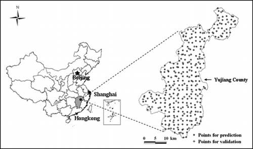
Figure 1 Location map of the study area and the soil sampling sites in southern China.
Soil sampling and laboratory analysis
In the present study, the soil sampling points consisted of prediction points (n = 254) and validation points (n = 85). Sampling points for prediction were collected on a regular square grid centered at 2 km × 2 km. Of the 254 samples for prediction, 127 were taken from paddy soil and the remaining samples were taken from red soil. Samples of paddy soil and red soil in the present study were further subdivided into six and four soil families, respectively (). All prediction points could also be classified into five land-use groups: paddy fields, upland field, forestland, vegetable fields and orchards. The validation samples contained all soil families and land-use groups present in the prediction samples, although they were collected by taking into consideration random and homogeneous distribution in the area. All samples in the present study were taken from the surface layer (0–20 cm) after crop harvest in November 2007. The sampling locations for each point were established by GPS, and related data for each point, such as land use, soil type and parent material, were described. The SOM content was determined using the K2Cr2O7 oxidation–titration approach (CitationNelson and Sommers 1982), and the SOC content is equal to the SOM content multiplied by 0.58 (Bemmelen transform coefficient).
Table 1 Soil organic carbon content (g kg−1) statistics for various soil types, land uses and land use–soil types
Variogram model and ordinary kriging
Geostatistics is a spatial analysis method based on regionalized variable theory and has been widely used to study spatial variability in soil attributes (CitationKerry and Oliver 2008). Spatial patterns of soil attributes following intrinsic stationarity can be described using the following semivariogram model: ![]() .
.
Ordinary kriging is expressed as a linear-weighted average of observations in the neighborhood of the unsampled location x 0:
Kriging combined with categorical auxiliary information
Because soil type and land use both have important impacts on SOC spatial distribution (CitationMomtaz et al. 2009; CitationZhang et al. 2009), soil type, land use and land use–soil type are used as auxiliary variables in KST, KLU and KLUST, respectively. The application of KST is described as an example, although KLU and KLUST are conceptually the same.
Studies show that soil samples generally have similar SOC contents within the same soil type as a result of similar pedogenic process, whereas there are great differences between different soil types (CitationLiu et al. 2006a). The SOC data are variable in the red soil hilly region owing to complicated soil types, which increases the uncertainty of SOC prediction. To reduce this uncertainty, the SOC content z(x kj ) of every sample can be divided into two parts: mean value of the type, which the sample belongs to, and the corresponding residual r(x kj ) in KST.
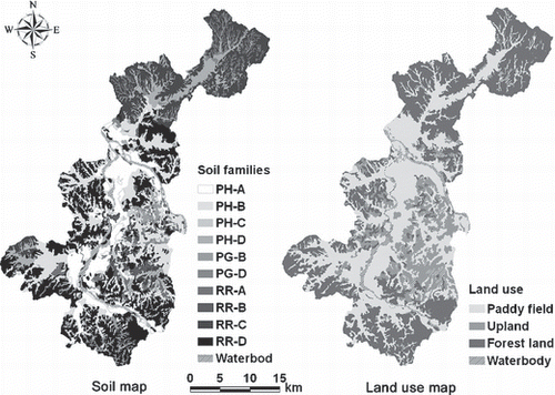
Then, the residual r(x kj ) can be treated as a new stationary regionalized variable and can be used for spatial interpolation in KST. The variogram γ r (h) and prediction formula of the residual are stated as EquationEqs 5 and Equation6, respectively. Because the soil type information of every unknown point to be estimated is available from the soil map () (1:50,000; from the Second National Soil Survey of China in the 1980s–1990s), the final predicted value Z*(x kj ) of the unknown point is the sum of the residual r*(x kj ) and the mean value of the corresponding soil type μ(t k ) (EquationEqn 7).
A number of studies have indicated that land use has a greater impact on SOC content than soil type (CitationWei et al. 2008). Thus, the SOC content of every sample can also be divided into a mean value for the land-use pattern μ(t k ) and a related residual r(x kj ) that can be used for kriging interpolation in KLU. The predicted value Z*(x kj ) of every unknown point can also be determined by adding the predicted r*(x kj ) to the SOC mean values μ(t k ) of the corresponding land use to which the unknown point belongs, and can be obtained from the land-use map () (China Land-use Data Base from the Institute of Geographic Sciences and Natural Resources Research, Chinese Academy of Sciences). Similarly, the SOC content of every unknown point can also be estimated by adding the predicted r*(x kj ) to the mean value μ(t k ) of the corresponding land use–soil type, which can be acquired by overlapping the soil and land-use maps. In the present study, spatial predictions of SOC content were carried out at the soil family category in the KST and KLUST approaches.
Figure 2 Soil (at the family level) and land use of the study area. The 10 families belong to two great groups including paddy soil (Anthrosols, WRB) and red soil (Acrisols, WRB), and three subgroups including Hydromorphic (Hydragric Anthrosols, WRB), Gleyed (Gleyic-Hydragic Anthrosols, WRB) and Red soil (Acrisols, WRB), which are abbreviated as PH, PG and RR. Soil families are classified mainly according to parent materials. A, B, C, D and E are labels for the following parent materials, alluvium, sandy conglomerate, quaternary red clay, shale and red sandstone, respectively.
Evaluation of the various prediction approaches
To evaluate the prediction precision of the various interpolation methods, we compared the Pearson’s correlation coefficient (r) between the predicted and measured values of the 85 validation samples as well as the root mean square error (RMSE) for various methods. The RMSE is calculated using the following equation:
The semivariograms were characterized and modeled using the software package GS+ 5.3 (CitationGamma Design Software 1994), and kriging interpolations were conducted in ArcGIS 9.2 (ESRI, Redlands, CA, USA). Statistical analyses were conducted in SPSS 13.0 for Windows (SPSS, Chicago, IL, USA) and the RMSE comparison charts were drawn using OriginPro 8.0 (OriginLab Corporation, MA, Northampton USA).
Results
Statistical characterization of the soil organic carbon data
The descriptive statistics for sampled SOC content are referenced in . The mean SOC content of all samples was 14.8 g kg−1. Of the 254 samples, the lowest and highest SOC contents were 3.07 and 36.4 g kg−1, respectively, the latter is approximately 12-fold as high as the former. The coefficient of variation (CV) of all samples is 50.20%. When all samples are classified into soil families, paddy soil has higher SOC contents than red soil, and the mean SOC content of PG-D was the highest (24.23 g kg−1), whereas that of RR-B was the lowest (7.68 g kg−1), only one-third of the former. However, considering the CVs of all soil families, those associated with red soil are generally much higher than those belonging to paddy soil; the highest is 55.38% (RR-D) and the lowest is 10.11% (PH-C). When all samples are classified into five land-use groups, their SOC contents in descending order were: paddy fields (18.31 g kg−1), vegetable fields (16.28 g kg−1), forestland (15.81 g kg−1), orchards (10.66 g kg−1) and upland fields (8.99 g kg−1). The CVs of the forestland and paddy fields were the highest (62.97%) and the lowest (30.12%), respectively, with the latter being less than half of the former. Furthermore, with all samples being classified according to land-use patterns, and then samples of a given land-use subdivided according to soil families, a total of 15 soil families was obtained (). With the exception of the families associated with paddy fields, RR-D in upland had higher SOC content and the other three families (RR-B, C and E) in upland all had lower contents. The forestland includes two soil families whose mean SOC contents differ greatly from each other. No marked difference was found in the SOC content between the two soil families associated with the vegetable fields. There was only a single soil family mapped to orchards, and this family had a low mean SOC content (10.66 g kg−1).
Figure 3 Histograms of (a) soil organic carbon original data, (b) the residuals by removing the mean values of soil type, (c) land use and (d) land use–soil type.
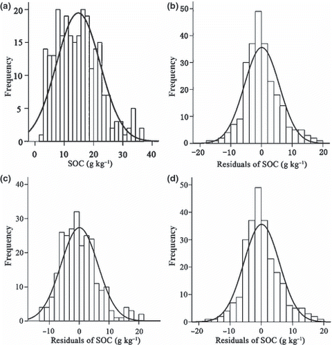
To avoid a scale effect and the related larger estimation error when the semivariogram function is calculated, the SOC data need to be normally distributed. The original SOC content data and the residual data after removing the mean value of soil type, land use and land use–soil type all fit to a normal distribution ().
Geostatistical analysis
The parameters of the semivariogram models for the different kriging methods are outlined in . The parameters indicate that the semivariogram of the original SOC data for OK is best fit by an exponential model, and those of the residuals for KST, KLU and KLUST are best fit by spherical models. There are some differences among the model parameters for various prediction methods (). In general, the semivariogram of OK has larger Sill, C/Sill and Range, and these parameters of the semivariograms of KST, KLU and KLUST are gradually reduced. The semivariogram of KLUST has the smallest Sill and Range, whereas the smallest C0 and C/Sill were observed in the semivariograms of KLU and KST, respectively.
Comparative analysis of the prediction accuracy for various approaches
The correlation between the observed and predicted values of SOC content and the RMSEs from the four kriging options are shown in . The results demonstrate that the strength of the correlation between the observed and predicted values obtained from the different kriging interpolation methods are all significant (P < 0.01). The correlation coefficient (r) from OK is the lowest (r = 0.383), whereas that from KLUST is the largest (r = 0.854). The correlation coefficients from KST (r = 0.784) and KLU (r = 0.795) represent the mid-range. The RMSE associated with applying OK for interpolating SOC is 6.49 g kg−1, the greatest value of the group, whereas that from KLUST (3.47 g kg−1) is the lowest, and the values from KST (4.15 g kg−1) and KLU (3.95 g kg−1) are in between. Compared with the RMSE from OK, the RMSEs from KST, KLU and KLUST are 36, 39 and 47% lower, respectively.
Table 2 Best-fit semivariogram models and their parameters for the various prediction approaches
Figure 4 Semivariograms of the studied interpolation approaches (a, b, c and d are for ordinary kriging [OK], kriging combined with soil-type information [KST], land use [KLU] and combined land use–soil type information [KLUST], respectively).
![Figure 4 Semivariograms of the studied interpolation approaches (a, b, c and d are for ordinary kriging [OK], kriging combined with soil-type information [KST], land use [KLU] and combined land use–soil type information [KLUST], respectively).](/cms/asset/a5282633-3f53-451c-99b7-c7ba073b17e6/tssp_a_10382797_o_f0004g.gif)
Figure 5 Relationship between the predicted and observed soil organic content from the interpolation methods (a, b, c, and d are for ordinary kriging [OK], kriging combined with soil-type information [KST], land use [KLU] and combined land use–soil type information [KLUST], respectively).
![Figure 5 Relationship between the predicted and observed soil organic content from the interpolation methods (a, b, c, and d are for ordinary kriging [OK], kriging combined with soil-type information [KST], land use [KLU] and combined land use–soil type information [KLUST], respectively).](/cms/asset/0ca35a3c-b191-4019-a69c-8530abc0c959/tssp_a_10382797_o_f0005g.gif)
Figure 6 Comparison of the root mean square error (RMSE) associated with the application of different kriging interpolations in paddy and red soils.
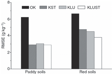
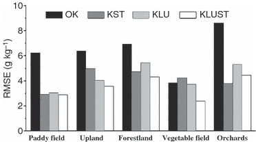
The r values and RMSEs of the various prediction approaches only reflect the overall error of prediction. To account for the prediction errors for the different interpolation approaches in more detail, the RMSEs associated with various soil types and land uses were compared. The RMSE comparison for soil types was conducted at the great group category (i.e. paddy soil and red soil) because at the soil family level there were not enough validation samples for meaningful statistical analysis. The RMSEs associated with paddy soil and red soil from the application of the different kriging methods are shown in , and those for red soil are all distinctly higher than those of paddy soil, The greatest difference in RMSE between red soil and paddy soil is related to KST, and the largest difference in red soil and the smallest difference in paddy soil are 4.77 and 2.92 g kg−1, respectively. The smallest RMSE difference was affiliated with the application of OK, and the values for red soil and paddy soil were 6.64 and 6.23 g kg−1, respectively. Taking into account the RMSEs for the different land uses, the application of OK results in the greatest RMSEs. Orchards are associated with particularly elevated RMSEs, whereas the RMSE for vegetable fields remains low (). Overall KLUST has the lowest RMSE associated with the different land-use groups, except orchards. The RMSE is distinctly lower for vegetable fields and upland fields. Compared with KLU, KST has a slightly lower RMSE in paddy fields, forestland and orchards, but a greater RMSE in upland fields and vegetable fields.
Spatial distribution of soil organic carbon from the four prediction approaches
The SOC spatial distribution maps generated by OK, KST, KLU and KLUST interpolation are presented in . All maps have similar trends, with a patch of elevated SOC values in the north and south-west areas and a region of low values in the middle area of Yujiang County. Considering the four distribution maps of predicted SOC, the smoothest one is from OK, characterized by very large polygons that change from higher or lower SOC content levels smoothly, whereas those from KST, KLU and KLUST all have fragmented polygons with an abrupt change that implies that more SOC distribution information is contained. Although the maps from the latter three approaches have a more similar pattern, differences in local area details exist in the maps. The mapped polygons from KST, KLU and KLUST interpolation vary in accord with soil type, land use and land use–soil type, respectively. A comparison of the four maps indicates that the one from OK is the coarsest, whereas the one from KLUST is the most detailed.
Figure 7 Comparison of the root mean square error (RMSE) associated with the application of different kriging interpolations by land-use group.
Discussion
Pronounced SOC spatial variability is found in the hilly red soil areas of South China as the result of complicated soil types and diversified land uses. The SOC content in the study area was closely correlated to the soil type (). Considering all sampled soil families, the SOC contents of the families belonging to the paddy soils great group are generally much higher than those of families belonging to the red soil great group. This is in agreement with CitationLiu et al. (2006a) who proposed a strong correlation between soil organic matter and soil type. Because of abundant input plant residuals and slow decomposition of soil organic matter owing to long periods of flooding, families in the paddy soil great group all have higher SOC contents than those in the red soil, particularly those in the Gleyed subgroup. PG-D has the highest SOC content because it is flooded all year around. Conversely, the red soil families usually have lower SOC contents because of relatively few organic matter inputs and a rapid SOC decomposition rate. In addition to the difference between paddy soil and red soil, differences can be observed among the soil families within the paddy soil and red soil great groups. For example, the greatest SOC content difference between the red soil families was found by comparing RR-B (7.68 g kg−1) and RR-C (17.61 g kg−1). The former is mainly found in upland fields in the middle of the county, whereas the latter mainly underlies forestland in the north and south of China.
Figure 8 Soil organic carbon (SOC) distribution maps generated from the four kriging approaches (a, b, c, and d are for ordinary kriging [OK], kriging combined with soil-type information [KST], land use [KLU] and combined land use–soil type information [KLUST], respectively).
![Figure 8 Soil organic carbon (SOC) distribution maps generated from the four kriging approaches (a, b, c, and d are for ordinary kriging [OK], kriging combined with soil-type information [KST], land use [KLU] and combined land use–soil type information [KLUST], respectively).](/cms/asset/3bd0c2d9-7dde-4500-9ae5-c1fdce405211/tssp_a_10382797_o_f0008g.gif)
Similarly, the SOC content was also found to be correlated with land use, and this result is consistent with previous studies (CitationLiu et al. 2006b; CitationWang et al. 2009). The effect of different land uses on SOC content is dependent on the balance between organic matter inputs and decomposition (CitationLal and Kimble 1997; CitationLiu et al. 2006b). In general, paddy fields, vegetable fields and forestland all have higher SOC contents as a result of greater organic matter input, whereas uplands and orchards both have lower SOC contents because of less fertilizer input and less output, as well not being regarded as primary land use for agricultural production. The results demonstrate that SOC content is closely related to both soil type and land use, and that categorical information is a valuable input to kriging interpolation to improve spatial prediction accuracy.
All semivariogram parameters have specific geostatistic means and important effects on spatial prediction. After removing the mean values of soil type (at the family level), land use and land use–soil type, respectively, the semivariograms of the residuals are quite different from that of the original SOC data (). In general, the parameters of Sill, C/Sill and Ranges for the residuals are all lower than those of the original SOC data because the structural variances of the semivariogram derived from soil types and land-use patterns were eliminated after removing the mean values for the categorical variables, but the random variance (caused by fertilizer application, farming system and straw application) increased. The relative parameter changes indicate that the original SOC content data were not stationary over the whole area, and that mean SOC values for soil type and land use (called local trend) contribute distinctly to the spatial variation of Z(x kj ) and also have an important effect on kriging estimation in the presence of spatial prediction uncertainty (CitationLiu et al. 2006a). Therefore, it is necessary to eliminate local trend effects to improve prediction accuracy. For this reason, KST, KLU and KLUST support local trend elimination originating from soil types, land uses and land use–soil types, respectively.
A comparison of the results from the application of the different kriging approaches demonstrates that there are distinct differences among the prediction methods. As can be seen in , the differences between correlation coefficients of the predicted and observed SOC contents become larger and the RMSEs become lower from a (r = 0.383, RMSE = 6.49 g kg−1) to d (r = 0.854, RMSE = 3.47 g kg−1). That trend indicates the prediction accuracies improve from OK to KLUST. This smoothing effect is a known characteristic of kriging interpolation that causes low values to be overestimated and high values to be underestimated (CitationLark and Webster 2006). In the present study, the original SOC data applied with OK interpolation results in the most variation because it does not account for the difference among soil types or land uses, so the predicted values of unknown points generated from OK are greatly affected by the smoothing effect, resulting in the smallest range. However, the influence of the smoothing effect when applying KST and KLU is greatly reduced compared with the results obtained with OK interpolation, which is attributable to variation in SOC among soil types and land uses. The influence of the smoothing effect on KLUST is further reduced when the SOC content variability attributable to both soil type and land use is considered, and the predicted values are more accurate over a larger range. However, even in case d in , the correlation coefficient is 0.688, indicating that there are still some lower values being overestimated and some higher values being underestimated. The remaining residuals after removing the SOC mean values associated with land use–soil type still have some unexplained variance, and at some level the smoothing effect will be inevitable when the linear unbiased estimation of kriging is carried out. Therefore, it can be seen that the smoothing effect commonly exists in kriging interpolation.
The SOC content varies with both soil type and prediction method, resulting in unique accuracies (). For example, the CVs of the families in the red soil great group are usually higher than the CVs of the families associated with the paddy soil great group, indicating that uncertainty in spatial prediction in red soil is greater than that for paddy soil. In a practical sense if the same prediction accuracy is wanted, then more samples from red soil areas are needed. This is in agreement with CitationConant and Paustian (2002) who proposed that the soil sample size needed for revealing SOC spatial distribution is affected by the CV of the soil properties. Similarly, for all land uses, both orchards and forestland have relatively high SOC CVs with greater uncertainty for spatial prediction, thus they have higher RMSEs (). Conversely, the paddy and vegetable fields both have lower RMSEs owing to the lower SOC CVs. In general, no matter the prediction accuracies for various soil types or for various land uses, KLUST usually has the highest accuracy, whereas OK has the lowest accuracy.
Distribution maps illustrate that the four approaches vary in their performance for interpolating SOC content (). The most pronounced smoothing affect is evident in the map generated from the OK interpolation. It displays large, smooth delineations, which only reflect the general SOC distribution pattern and mask any local SOC variation accounted for by soil type and land use. When taking both soil type and land use into account, the KLUST SOC distribution map has fragmented delineations that best reflect the local variation of SOC. To a lesser degree, but more accurate than OK interpolation, KST and KLU can only reflect SOC variation attributable to soil type and land use, respectively.
In conclusion, by comparing the performance of OK, KST, KLU and KLUST, the results indicate that KLUST performed best not only in SOC prediction accuracy, but also for interpolating a SOC distribution map, and OK performed worst. Interpolations generated from KST and KLU performed much better than OK, but worse than KLUST. Our results suggest that categorical information describing soil types and land uses can be used as auxiliary information for kriging to improve the accuracy of SOC spatial prediction, and that KLUST is an efficient approach for SOC spatial prediction in hilly red soil areas of China.
Conclusion
Hilly red soil areas in South China exhibit wide SOC spatial variability owing to complicated soil types and diverse land uses. The original SOC content data for the study area are not stationary and OK interpolation results have low prediction accuracy. However, the application of attributes with kriging, that is, the KST and KLU methods, improves the prediction accuracy markedly as a result of local trend removal from the mean SOC values accounting for soil types and land uses, respectively. Our results indicate that soil type and land use both have a great effect on SOC spatial prediction. Combined categorical information kriging, namely KLUST, used the residuals for interpolation by removing the SOC mean values associated with land use and soil type, resulting in the highest prediction accuracy. The best mapping representation of the local SOC content variation was achieved using the KLUST method, when comparing the four approaches. Our results suggest that categorical soil type and land use information can be used as auxiliary data to improve SOC spatial interpolation, and KLUST is a realistic and efficient approach for SOC spatial prediction in the hilly red soil areas of South China.
Acknowledgments
We gratefully acknowledge support for this research from the Knowledge Innovation Program of Chinese Academy of Sciences (KSCX1-YW-09-02), the National Natural Science Foundation of China (No. 40921061, 40701070) and The Frontier Project of the Chinese Academy of Sciences (No. ISSASIP0715).
Related Research Data
References
- Bhupinderpal , S , Hedley , MJ , Saggar , S and Francis , GS . 2004 . Chemical fractionation to characterize changes in sulphur and carbon in soil caused by management . Eur. J. Soil Sci. , 55 : 79 – 90 .
- Chai , XR , Shen , CY , Yuan , XY and Huang , YF . 2008 . Spatial prediction of soil organic matter in the presence of different external trends with REML-EBLUP . Geoderma , 148 : 159 – 166 .
- Duffera , M , White , JG and Weisz , R . 2007 . Spatial variability of Southeastern US Coastal Plain soil physical properties: implications for site-specific management . Geoderma , 137 : 327 – 339 .
- Huang , B , Sun , WX Zhao , YC . 2007 . Temporal and spatial variability of soil organic matter and total nitrogen in an agricultural ecosystem as affected by farming practices . Geoderma , 139 : 336 – 345 .
- Jung , WK , Kitchen , NR , Sudduth , KA and Kremer , RJ . 2008 . Contrasting grain crop and grassland management effects on soil quality properties for a north-central Missouri claypan soil landscape . Soil Sci. Plant Nutr. , 54 : 960 – 971 .
- Kadono , A , Funakawa , S and Kosaki , T . 2009 . Factors controlling potentially mineralizable and recalcitrant soil organic matter in humid Asia . Soil Sci. Plant Nutr. , 55 : 243 – 251 .
- Kerry , R and Oliver , MA . 2007 . Comparing sampling needs for variograms of soil properties computed by the method of moments and residual maximum likelihood . Geoderma , 140 : 383 – 396 .
- Kerry , R and Oliver , MA . 2008 . Determining nugget: sill ratios of standardized variograms from aerial photographs to krige sparse soil data . Precis. Agric. , 9 : 33 – 56 .
- Lal , R and Kimble , JM . 1997 . Conservation tillage for carbon sequestration . Nutr. Cycl. Agroecosys. , 49 : 243 – 253 .
- Gamma Design Software . 1994 . “ GS1 for Windows v. 5.3.2 ” . Plainwell, MI : Gamma Design Software .
- Conant , RT and Paustian , K . 2002 . Spatial variability of soil organic carbon in grasslands: implications for detecting change at different scales . Environ. Pollut. , 116 : S127 – S135 .
- Wang , YQ , Zhang , XC and Huang , CQ . 2009 . Spatial variability of soil total nitrogen and soil total phosphorus under different land uses in a small watershed on the Loess Plateau, China . Geoderma , 150 : 141 – 149 .
- Shi , XZ , Xu , SX Yu , DS . 2009 . Cross-reference for relating Genetic Soil Classification of China with WRB at different scales . Geoderma , doi:10.1016/j.geoderma.2009.12.017
- Lark , RM and Webster , R . 2006 . Geostatistical mapping of geomorphic variables in the presence of trend . Earth Surf. Proc. Land. , 31 : 862 – 874 .
- Li , ZP , Zhang , TL and Chen , BY . 2006 . Changes of organic carbon and nutrient contents in highly productive paddy soils in Yujiang County of Jiangxi province . Scientia Agricultura Sinica , 39 : 324 – 330 . (in Chinese)
- Liu , TL , Juang , KW and Lee , DY . 2006a . Interpolating soil properties using kriging combined with categorical information of soil maps . Soil Sci. Soc. Am. J. , 70 : 1200 – 1209 .
- Liu , DW , Wang , ZM Zhang , B . 2006b . Spatial distribution of soil organic carbon and analysis of related factors in croplands of the black soil region, Northeast China . Agric. Ecosyst. Environ. , 113 : 73 – 81 .
- Matsumoto , N , Paisancharoen , K and Hakamata , T . 2008 . Carbon balance in maize fields under cattle manure application and no-tillage cultivation in Northeast Thailand . Soil Sci. Plant Nutr. , 54 : 277 – 288 .
- Meul , M and Van Meirvenne , M . 2003 . Kriging soil texture under different types of nonstationarity . Geoderma , 112 : 217 – 233 .
- Minasny , B and McBratney , AB . 2007 . Spatial prediction of soil properties using EBLUP with the Matern covariance function . Geoderma , 140 : 324 – 336 .
- Momtaz , HR , Jafarzadeh , AA Torabi , H . 2009 . An assessment of the variation in soil properties within and between landform in the Amol region, Iran . Geoderma , 149 : 10 – 18 .
- Mueller , TG and Pierce , FJ . 2003 . Soil carbon maps: enhancing spatial estimates with simple terrain attributes at multiple scales . Soil Sci. Soc. Am. J. , 67 : 258 – 267 .
- Navarrete , IA and Tsutsuki , K . 2008 . Land-use impact on soil carbon, nitrogen, neutral sugar composition and related chemical properties in a degraded Ultisol in Leyte, Philippines . Soil Sci. Plant Nutr. , 54 : 321 – 331 .
- Nelson , DW and Sommers , LE . 1982 . “ Total carbon, organic carbon, and organic matter ” . In Methods of Soil Analysis, Part 2-Chemical and Microbiological Properties , Edited by: Page , AL , Miller , RH and Keeney , DR . 539 – 594 . Madison, WI : ASA-SSSA .
- Post , WM and Kwon , KC . 2000 . Soil carbon sequestration and land-use change: processes and potential . Glob Chang Biol. , 6 : 317 – 327 .
- Ruth , B and Lennartz , B . 2008 . Spatial variability of soil properties and rice yield along two catenas in southeast China . Pedosphere , 18 : 409 – 420 .
- Schulp , CJE and Veldkamp , A . 2008 . Long-term landscape - land use interactions as explaining factor for soil organic matter variability in Dutch agricultural landscapes . Geoderma , 146 : 457 – 465 .
- Soil Survey Office of Yujiang County . 1986 . Soil species of Yujiang County , 23 – 31 . China Agriculture Press . (in Chinese)
- Somaratne , S , Seneviratne , G and Coomaraswamy , U . 2005 . Prediction of soil organic carbon across different land-use patterns: a neural network approach . Soil Sci. Soc. Am. J. , 69 : 1580 – 1589 .
- Sumfleth , K and Duttmann , R . 2008 . Prediction of soil property distribution in paddy soil landscapes using terrain data and satellite information as indicators . Ecol Indic , 8 : 485 – 501 .
- Terra , JA , Shaw , JN , Reeves , DW , Raper , RL , van Santen , E and Mask , PL . 2004 . Soil carbon relationships with terrain attributes, electrical conductivity, and a soil survey in a coastal plain landscape . Soil Sci. , 169 : 819 – 831 .
- Wei , JB , Xiao , DN , Zhang , XY and Li , XY . 2008 . Topography and land use effects on the spatial variation of soil organic carbon: a case study in a typical small watershed of the black soil region in northeast China . Eur. J. Soil Sci. , 41 : 39 – 47 .
- Zhang , HM , Wang , BR , Xu , MG and Fan , TL . 2009 . Crop yield and soil responses to long-term fertilization on a red soil in Southern China . Pedosphere , 19 : 199 – 207 .
- Zhao , YC , Xu , XH Huang , B . 2007 . Using robust kriging and sequential Gaussian simulation to delineate the copper- and lead-contaminated areas of a rapidly industrialized city in Yangtze River Delta, China . Environ. Geol. , 52 : 1423 – 1433 .