Abstract
This article describes an activity that integrates geographic information systems (GIS) and Internet technology to support problem-based learning (PBL) in geography and closely related disciplines. First, the article discusses the theoretical context of PBL and reviews notable PBL projects involving GIS and the Internet. Next, the article outlines step-by-step procedures for implementing the activity. In conclusion, the article recommends strategies for creating conducive, technology-rich environments for PBL in undergraduate geography courses, modules, and classrooms.
Introduction
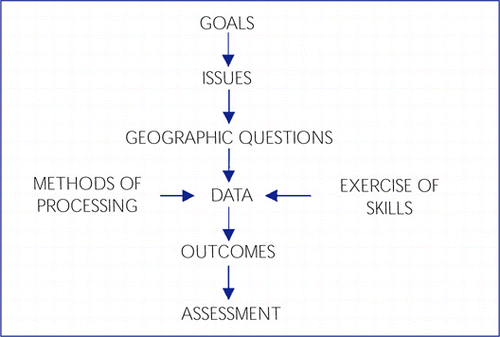
Problem-based learning (PBL) has a long tradition in geography education, particularly in the form of inquiry. CitationHill (1990) developed a learning model based on CitationSlater’s (1982) ideas of teaching geography as inquiry in the social studies curriculum (). This model uses questions as tools for planning lessons that teach new analytical and geographical skills and that address relevant social and environmental issues.
The Hill-Slater model has been applied to a variety of curriculum development projects, notably Geographic Inquiry into Global Issues (CitationHill 1995), and has served as a curricular resource for geography teacher education institutes in the United States. CitationLorsbach and Basolo, Jr., (1999) express particular enthusiasm for using inquiry as a method for teaching geographical issues, and according to some studies (e.g., CitationKlein 1995), inquiry can enhance content knowledge, geographic skills, and cross-cultural perspectives of environmental and social issues affecting individuals, communities, and nations.
Figure 1 Slater-Hill model for issues-based geographic inquiry (CitationHill 1990).
As the theoretical referent for inquiry and PBL, constructivism has also emerged as a guiding theory for teaching with GIS and the Internet. Keiper (1998), for example, reports on the use of GIS to design constructivist learning projects for elementary school students. Using a simplified userinterface, the students in Keiper’s case study examined and manipulated data layers to decide where to locate a new playground facility in their local neighbourhood.
One of the pioneers in on-line GIS instruction is Dr. Kenneth Foote. Foote’s Geographer’s Craft project, which he developed at the University of Texas at Austin, is a two-semester course that introduces students to GIS and other tools used by geographers for applied research (CitationFoote 1997). In this course, students combine resources on the World Wide Web with GIS, GPS, remote sensing, and computer cartography techniques to solve geographical problems.
As spatial data providers increase the amount of GIS data available to the public through the Internet, so too do opportunities for integrating GIS and the Internet in geography instruction. Although PBL with the Internet is not practised extensively in geography, variations of the method seem to have caught favour among many GIS instructors in the United States. CitationSolem (2000, 2001) analysed the content of undergraduate geography lessons on the Web and the methods adopted by geography faculty members and found that inquiry-based approaches to on-line instruction tend to be practised more frequently in geographic information science (GISci) courses. He attributes this finding to GISci faculty members’ comparatively higher levels of experience with computers, educational technology, and on-line data sources.
The next section of this paper outlines an activity that applies the Hill-Slater inquiry model to support PBL with GIS and the Internet. This activity was first assigned as a term project in an introductory GIS course1 at Southwest Texas State University in the spring of 2001. This course typically enrols 48 students who meet twice weekly for a 50-minute lecture followed by a 2-hour lab (two sections) taught by a graduate student assistant.
The procedures described below can be used by instructors to guide students through the process of using GIS to plan, carry out, and evaluate a collaborative inquiry project. Specific educational objectives include:
Demonstrate understanding of spatial analysis and fundamental GIS knowledge and skills;
Work collaboratively on using GIS to solve a local geographical problem; and
Understand the scholarly and practical importance of Internet technology for GIS.
Activity procedures
I assign this activity approximately half-way through the semester, after covering fundamental GIS topics such as spatial data structures, data input methods, map projections, co-ordinate systems, and so forth. By that time in the course, students have gained hands-on practice with GIS in lab and are beginning to learn basic spatial analysis techniques (buffering, overlaying, spatial queries, classification, etc.), and therefore are ready to begin conceiving a practical GIS application when the activity is presented to them.
I. Form project teams. In the real world, much GIS work is collaborative work. Even a modest GIS project requires a lot of planning and effort, and multiple partners can bring several talents to bear on learning tasks and increase the likelihood that work will be completed in a timely, efficient manner.
Have students form a team with two or three partner(s). Point out that project grades will ultimately be a reflection of both individual and group performance (see Assessment procedures below). On occasion, individual students resist group work or fail to co-operate fully with their team members. Therefore, aim for a total of 3–4 students per group so that any given team will not be hindered by the failure of one individual to participate.
II. Choose a topic. Geographers study relationships among people, places, and environments and address many important issues in their work. Once students form their groups, it is time for them to choose a topic for their project. Students should be given wide latitude in choosing a topic, yet their project should in some way address an authentic issue that is geographically relevant and of significance to people living in their state, province, or local community.
III. Pose research questions. Having decided upon their topic and formulated a problem statement, students should work together to brainstorm geographic questions for their research. Remind students that thinking and working geographically involves examining location, place, human-environment interaction, movement, and region — five themes that are fundamental to the geographer’s perspective of the world.
IV. Acquire GIS data. Geographers need data to test hypotheses, build theory, and answer research questions. After students settle on their research questions, they must turn to the process of collecting data for their project. Because finding data can be a very time-consuming task, I suggest that instructors provide students with links to a variety of on-line data providers where they can download free spatial data sets.2 Note, however, that on-line data files can be very large and often must be decompressed using software like WinZip or Stuffit Expander.
V. Create a database and data dictionary. Even modest GIS projects can involve a dizzying amount of data that can confuse novice users. Students must be taught to construct and carefully manage a database so that their spatial, attribute, and/or image data are properly referenced, accurate, and capable of being processed in a GIS. Many students find it helpful to develop a data dictionary to help them better understand and manage their data.
V. Analyse data with GIS. This is the step where students can apply the various spatial analysis techniques that they presumably learned in lab exercises and tutorials. Encourage students to use diverse data displays (e.g., maps, tables, and charts) to help them interpret their data. Each method of analysis should be linked to a specific research question so students not only can describe what they are doing with their data, but also can explain why their methods are necessary for resolving the problem.
VI. Communicate results. PBL often culminates in an authentic assessment of student knowledge and skills. After students complete their GIS analysis, evaluate their learning with two performance-based assessments: a technical report published on the Web and an oral class presentation.
VI (a) Project Web Site. At a minimum, the on-line project report should contain the following items:
1. Title page (title should be phrased as a geographic question)
2. Names of team members
3. Abstract (100–150 word summary of project objectives, procedures, and results)
4. Table of Contents
5. List of Tables and Figures
4. Introduction (problem statement, research questions, and overview of report’s contents)
5. Background (500-word review of related GIS studies and applications)
6. Methodology (data collection, analysis, and management)
7. Results (findings and outcomes)
8. Conclusions and Recommendations (interpretation of the results and recommended solution(s) to the problem)
9. Limitations (missing data that might affect interpretation of results)
10. References
VI (b) Oral Presentation. Once groups complete their Web site, have them prepare a 10-minute classroom presentation in which they discuss the general problem under study and explain how they used GIS to address the problem. At a minimum, the oral presentation should:
Introduce the topic and purpose of the project;
Develop the project’s background by summarising the relevant literature, with some details;
Explain how and why data were collected and managed;
Present the results of the GIS analysis;
State the conclusions and recommendations; and
Allow 1–2 minutes for questions from the audience.
VII. Assessment. Assign grades based on your evaluation of students’ knowledge and understanding of GIS, their ability to work collaboratively in a team, and the extent to which their project addresses a relevant issue from a geographic perspective. Both group and individual effort can factor into the assessment, as follows:
VII (a) Personal Evaluation. Have each team member submit a 1-page typed statement describing his or her individual contribution to each component of the project — GIS lab work, project Web site, and the oral presentation.
VII (b) Team Member Evaluation. In addition, each team member can complete the following scales for each of their partners. A brief written evaluation may be included with each scale.
I would rate [team member’s name] contribution to the GIS lab work as a(n):
I would rate [team member’s name] contribution to the project Web site as a(n):
I would rate [team member’s name] contribution to the oral presentation as a(n):
Conclusions and Recommendations
The activity outlined in this paper is a challenging task for both students and instructors. PBL involves a complement of intellectual, social, and practical skills, many of which are new or underdeveloped among undergraduate students. Moreover, the activity requires a considerable amount of planning, facilitation, and mentoring by the instructor. The following strategies were found to be crucial factors in successfully preparing students for undertaking the task of GIS-based collaborative inquiry:
Build a co-operative and constructivist learning environment. Many students are unaccustomed to PBL and working on tasks with classmates as equal partners. Because the GIS activity requires students to work collaboratively, exercise critical thinking, and apply new geographic concepts, students should be given ample opportunity to exercise and refine these skills. With this in mind, I weave co-operative learning activities into every 50-minute lecture period to reinforce fundamental GIS and geographic concepts. These activities are designed to complement the key components of the Hill-Slater inquiry model and include role-plays, simulations, library research, computer and Internet exercises, and small-group discussions.
Familiarise students with working and communicating on-line. One of the main learning objectives of the GIS activity is to improve communication and research skills with the Internet. Although many students are familiar with e-mail and the World Wide Web, relatively few know how to communicate effectively with hypermedia, and fewer still understand how to search for and retrieve spatial data the Web. Early in the semester, I assign a series of activities to train students in the basics of Web page construction, exploring on-line databases, and importing digital data into ArcView GIS, so that they are proficient in these technical skills by the time the GIS activity is assigned.
Schedule office consultations. About one-month before the project due-date, I dedicate a week of lecture time for groups to consult individually with me on their projects. The purpose of these consultations is to ensure that groups make timely progress toward completion of the project, and also to define further my constructivist role as a facilitator and collaborator of learning. I stipulate that all group members be present for the meeting and prepared to discuss their proposed topic, research questions, methodology, and work plan.
Provide students with adequate laboratory time. This GIS activity requires several hours of additional lab work beyond regularly scheduled lab periods, and therefore access to labs was a very important consideration. Accordingly, I schedule open lab periods during the final two weeks of the course and arrange for labs to be kept open after-hours.
It is questionable whether this activity could be successfully implemented in a larger course or in a course lacking staff assistance. Although some readers might doubt the feasibility of teaching this activity in an introductory course, the overall quality of student work affirmed my belief that with foresight, technical support, and purposive instruction, students can achieve the tasks set forth in the activity with creativity, skill, and enthusiasm.
The author invites readers to contact him with comments, questions, and suggestions for improving this activity.
Notes
1. Course materials, lesson plans, links to student GIS projects, and other learning resources are available on-line at: http://courseinfo.mediasrv.swt.edu/courses/GEO2426/.
2. In the United States, many local, state, and federal government agencies offer free spatial data ready to be imported into a GIS. The provision of free or inexpensive spatial data over the Internet may not be extensively practised in other countries, in which case instructors will need to supply local data or explore alternative sources and data entry procedures.
References
- Foote, K. E. (1997). The Geographer’s Craft: Teaching GIS in the Web. Transactions in Geographic Information Systems (GIS), 2: 137-150.
- HillA.D. (1990). A model for issue-based geographic inquiry in secondary schools. Geographic Inquiry into Global Issues Bulletin 1A (Boulder, CO: Center for Geography Education), 11 pp.
- HillA.D. (ed) (1995). Geographic Inquiry into Global Issues (GIGI). Chicago: Encyclopedia Britannica Educational Corporation.
- KeiperT.A. (1999). GIS for elementary students: an inquiry into a new approach to learning geography. Journal of Geography, 98(2): 47-59.
- KleinP.A. (1995). Using inquiry to enhance the learning and appreciation of geography. Journal of Geography, 94(2): 358 - 367.
- LorsbachA.W., and BasoloJr.F. (1999). Problem-based learning. In Surfing Social Studies, eds. J.BraunJr., and C.F.Risinger, C.F., pp. 121 - 128. Washington, DC: National Council for the Social Studies.
- SlaterF. (1982). Learning Through Geography. Oxford, UK: Heinemann Educational Books.
- SolemM.N. (2000). Differential adoption of Internet-based teaching practices in college geography. Journal of Geography, 99(5): 219-227.
- SolemM.N. (2001). A scoring guide for assessing issues-based geographic inquiry on the Web. Journal of Geography, 100(2): 87-94.