Abstract
C & IT is used at Derby in a variety of modes including pre-fieldwork training, post-fieldwork assessment and field-related courseware development as part of student project work. With respect to pre-fieldwork training, all students are required to undertake the UK Earth Science Courseware Consortium (UKESCC) ‘Field Safety Tutorial’ and to register their medical conditions on line using a Field Course Registration package. For field mapping, both the Field Safety Tutorial and the UKESCC ‘Using the Compass-clinometer’ courseware module are integrated into a programme of pre-course preparation sessions, involving the use of ‘in-house’ courseware, that must be completed by all students. Computer-based assessment of recent field experience is used on a number of modules to substitute for, or to supplement data obtained from, field assessments, and students are now able to submit field-related courseware modules as final-year projects. Future developments include integrated computer-based assessment of field, laboratory and theoretical work and the automated linking of records of progression through the UKESCC Field Safety Tutorial with a Field Course Registration program. These developments are planned in the context of rapidly changing course structures and the likely ‘shelf life’ of the software will be fully evaluated before committing resources to their production. This article will be of interest to GEES academics perhaps considering using C & IT to support fieldwork and assessment in their own departments/institutions.
Introduction
Current use of Communications and Information Technology (C & IT) in fieldwork teaching at Derby has built upon developments in the areas of interactive assessment that started in 1989 and of courseware production for the UK Earth Science Courseware Consortium (UKESCC) that started in 1992. The Division of Earth Sciences at Derby has provided the assessment software that underpins the HEFCE-FDTL funded TRIADS, Assessment of Learning Outcomes project (1996 to 2001, Universities of Liverpool (lead site), Derby and Open University). A description of the functionality and application of the TRIADS system may be found in Mackenzie (1999) or via the Centre for Interactive Assessment Development web site at URL: http://www.derby.ac.uk/ciad/.
C & IT is increasingly being used to support fieldwork in Earth Sciences in the areas of pre-fieldwork training, post-fieldwork assessment and as a suitable vehicle for student project work. Much of this is currently geared to the more efficient use of expensive field time and to ensuring that all students receive appropriate safety training. Future applications will address the integration of field and laboratory assessments.
General pre-fieldwork training
1. Field safety training and field course registration
Prior to entry into the field, all students are required to undertake the UKESCC ‘Field Safety’ courseware module (CitationMackenzie & Wilkins, 1999) and to register for each field course using separate ‘Field Course Registration’ software that has been developed ‘in house’.
The Field Course Registration software for students provides online selection of field courses to be attended, together with facilities for input of medical information, dietary requirements, safety certification and next of kin. A separate program is in development that allows field tutors to retrieve this information for those students registered on any particular field course so that they are aware of potential medical problems that might arise during the course.
2. Geological Field & Map Skills and Geological Field Mapping
Extensive use of computer-based tutorials is made within the first year Geological Field and Map Skills module which acts as a preparation for the Introduction to Geological Field Mapping module that runs during the first three weeks of the second year of the course.
In the Geological Field and Map Skills module, students are required to undertake a series of mapwork exercises supported by weekly tutorial sessions and interactive courseware introducing the principle of structure contours and their application to predict outcrop patterns. As part of this software, we have developed computer-based questions using the TRIADSystem (CitationMackenzie, 1999) that require the student to draw geological boundaries on contoured landscapes. The closeness to the correct answer can be scored in some detail and different areas of the outcrop may be variably weighted in the scoring. Recent developments have facilitated the scoring of the positioning of multiple geological boundaries. This means that the geological map construction and interpretation skills of students may now be very accurately assessed. Some of the questions used in previous years assessments have now been incorporated into the formative courseware. A selection of these may be viewed in the current TRIADS demonstration that may be accessed via the CIAD site at http://www.derby.ac.uk/ciad/.
With respect to field mapping, both the UKESCC Field Safety module and the UKESCC ‘Using the Compass-clinometer’ courseware module (CitationMackenzie & Wilkins, 1994) are integrated into the preparation sessions for the Geological Field Mapping module. Students are required to attend two full days of preparatory sessions that additionally cover selection of mapping areas, safety procedures, accommodation arrangements and a Field Mapping Simulation exercise. The latter exercise is currently paperbased but it is planned to convert this into a computer-based exercise in 2003, now that the algorithms for testing the on-screen drawing of multiple curved lines have been developed.
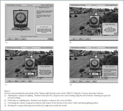
We have found that the prior use of the UKESCC ‘Using the Compassclinometer’ module saves a substantial amount of expensive field time, since most students are at least familiar with the instrument and require only a quick confidence-boosting revision of its use when in the field. The high level of interactivity in this module is designed to give users a real feel for the instrument and its application that would normally only be acquired by small-group tuition in the field ().
Post-fieldwork assessment
Computer-based assessment of students has been used at Derby for a variety of Ear th Science modules since 1989 (CitationMackenzie, 1997). Computer-based assessment of recent field experience was first tried with respect to a structural geology aspect of a first-year field course in the Highlands of Scotland (CitationMackenzie & Stowell, 1998; Mackenzie, 1998). The assessment replaced a field examination that was often marred by bad weather conditions and generated a significant marking load of field notes in varying states of preservation. The new assessment was structured so that students were required to make full field descriptions of the locality in their field notebooks after some prior training at a related locality. The notebooks were collected at the end of the day and marked for quality and relevance of field sketches. The field notebooks were returned to the students for reference at the computer-based assessment some two to three weeks later. The rationale was to test the students’ ability to record information and interpretations of the geology accurately in the field and then to retrieve them at a later date, once the memory of the details of the locality had faded. This assessment worked well until the venue of the first-year field course was changed. This emphasises the need to ensure that where such computer-based assessments are planned, the fieldcourse will have a sufficiently long shelf life to make their development an economically viable proposition.
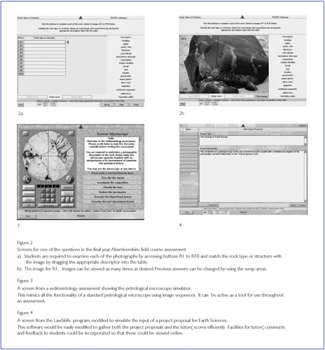
At a higher level, computer-based assessment of recent field experience has been investigated for field work in the final year module “Crustal Tectonics”. The field course, based in Northeast Scotland, involves: Buchan and Barrovian mineral assemblages, regional metamorphic zones, isograds in pelites & calc-silicates, and PT interpretation; sedimentary structures for interpretation of way-up in metamorphic rocks and structural facing directions; mineralogy and timing of granite pegmatites and aplite sheets; migmatites, melting isograds and melt extraction relations; gabbros, metagabbros, serpentinites and augen gneisses; magma mingling and hybrid formation; shear zone deformation; and considerations for geochronology. An example question from this test is shown in .
Prior to 2000, participants were assessed by a field examination. The exercise was invigilated whilst the candidates collected field notes from a small area of rock outcrop in a controlled time. Field photographs, collected over several years on the same field trip, were initially used as a basis for a computer-based assessment that acted as a re-sit package for students who failed the field examination. Testing of the package on the 2000 cohort who had already sat the field exam, allowed a controlled trial of the technique as a possible complete substitute for the field exam. The results showed a reasonable correlation, although the students scored better on the field exam. This could simply have been explained by the time lag between learning and assessment being longer in the case of the computer assessment but there are other differences. A wider range of field structures was examined in the computer-based assessment and here it had potential advantages over the field exam. However, perhaps more importantly, the trial computer assessment gave less opportunity for the better student to demonstrate interpretative skills. The latter problem might not have been too serious for a re-sit package where a maximum of D- could be scored according to the University’s resit regulations. However, it was clear that further development would be required before it could be used as a substitute for the field examination. This development took place in 2001 with the collection of more specific photographs linked to new questions built around interpretive skills (e.g. working out structural facing direction). The assessment was tested again with the new questions and earlier in the semester to achieve a shorter time lag between learning and assessment. The results were very good and, after some final adjustment to photograph quality and the distribution of subsections in questions, the assessment ran for the 2002 cohort in October as a substitute for the field exam.
It can be difficult to replace the three-dimensional aspects of field geology in a two dimensional medium but the judicious use of Quicktime-VR (a package that allows the creation of 360-degree panoramic views and images of objects viewable from all sides) greatly facilitates doing this. Controlled image panning sequences such as those used on Discovering Geology CD-Roms (Open University) can be used with some partial success to overcome this deficiency.
In general, we consider that computer-based assessments can be usefully employed to assess recent field experience, but require careful development in order to be able to test the full range of skills assessed in a field examination. Such developments can provide a substantial increase in the available field tuition time and are worthwhile where field examinations are held in localities that are likely to be used over many years. The real advantage of computer-based assessments lies in their objectivity and, when switched to formative mode, their ability to provide detailed feedback that is uniform for all students.
Field-related courseware development projects
At Derby, students are given a ‘guided’ free hand at defining the topics for their final-year projects. Recently a number have elected to produce fieldrelated courseware packages. These are valuable, in as much as they develop transferable skills in addition to the geological content.
We have found that it is important to impress upon students undertaking such projects the need for very clear definition of educational aims, the scope of the content and level of the target audience. Such projects are not an easy option and require educational awareness, programming aptitude, graphic design capability coupled with sound geological fieldwork, organisation and planning skills in order to complete them successfully. This combination of abilities is not at all common.
Courseware packages that are of sufficiently high calibre may be developed into on-line tutorial material for all students. One of these is the subject of a separate paper in the previous issue of Planet (CitationSmith et al. 2001).
Current and Future developments
1. Integrated field and laboratory assessments
One of the significant development areas for computer-based assessments lies in the provision of integrated assessments that are currently difficult to assess by any means other than individual project reports. For example, it would be possible to deliver assessments of fieldwork that cover field mapping, field observation, laboratory examination of field samples and the application of theoretical concepts to their interpretation. We have already noted above that it is now possible to test and score the position of curved lines drawn on a geological map. A petrological microscope simulator, such as the one shown in Figure 3, can be made available to test the student’s ability to describe and interpret thin sections of samples as part of a field assessment. Scanning electron microscope images, heating-freezing stage simulations or chemical analyses could also be made available during the assessment to provide an integrated theoretical and practical environment for geological interpretation.
A current development is centred on an eight-day field course to Tenerife. The fieldwork supports the second year volcanology module and provides students with the opportunity to study a wide range of volcanological and petrological phenomena on an active volcano. Students will have their understanding of theoretical, practical and field aspects of the module assessed in a one hour on-line examination that integrates a computer microscope simulator, plotting and evaluation of geochemical data, and the identification and interpretation of randomly generated field relations and volcanological phenomena.
2. On-line submission of material to meet deadlines or for manual assessment
It is not possible to score all student activities by computer, but it is possible to use interactive computer programs to collect and collate assignments for manual marking by tutors.
Software with this functionality has been developed at the Centre for Interactive Assessment Development for the Law Division at Derby. Its operation has greatly facilitated the collection of project-proposal data and has the added advantage that the software enforces the pre-defined deadlines. It would be a short step to modify the package developed for Law into one that has generic application to the submission and online scoring and commenting for project proposals or any other assignment that was ongoing and required submissions at staged deadlines. A screen from the Law software modified to simulate a geological projectproposal data-entry page is shown in Figure 4.
Conclusions
Ensuring that students have progressed through the appropriate prefield course training can be difficult. Linking the interactive training packages produced ‘in house’ and for the UKESCC to record files for each student will allow field tutors to check both the academic and medical preparedness of students on the course and to plan accordingly. Interactive pre-field course tutorials can allow much more efficient use of expensive field time.
The objective assessment of field notebooks can be time-consuming and difficult. One of the most important features of the notebook is the ability to retrieve critical data from it at a later date. Interactive assessment of recent field experience can efficiently test the quality of recording of field data and its interpretation. The possibility of testing the student’s ability to interpret field, laboratory and theoretical data in an integrated manner can be realised by the use of field images and software simulations of laboratory techniques.
The production of field related software can be a valuable addition to the range of topics suitable as final-year student projects. Careful counselling is required, however, in order to ensure that the student is fully aware of the level of planning and commitment that is necessary to complete such a project successfully.
The ease with which bespoke interactive software can be written using authoring packages such as Authorware Professional (MacromediaTM) means that many tasks requiring data or assignment collection from students may be performed online. Nevertheless, the production of good quality courseware and assessments still requires a substantial design effort in an environment of rapid change in the structure and content of undergraduate courses. It is thus important to ensure that any proposed developments will have a sufficiently long ‘shelf life’ for their creation to be an economic proposition.
Related Research Data
References
- MackenzieD. M. and WilkinsH. (1994) Preparing for Fieldwork 1 - Using a Compass-Clinometer. Interactive Courseware Module 2. University of Derby for the UK Earth Science Courseware Consortium, University of Manchester.
- MackenzieD.M. (1997) Computer Aided Assessment at the University of Derby. A case study in: Brown, G., Bull, J. and Pendlebury, M. (Eds) Assessing Student Learning in Higher Education. Chapter 13, 215-217. (Routledge, London)
- MackenzieD.M. and StowellJ.F.W. (1998) Computer-based Assessment of Recent Field Experience. A use of the TRIADS System. In:KingH. (ed) UK Geosciences Fieldwork Symposium Proceedings. ESTA Occasional Series, 2, 53-54.
- MackenzieD.M. (1998) The potential of Computer-delivered Assessment to test Recent Field Experience in a wider geological context. In: KingH. (ed) UK Geosciences Education Symposium Proceedings: Assessment in the New Millennium. University of Birmingham. 11th-12th. November 1998. Earth Science Staff Development Workshop Series, 9, 34.
- MackenzieD.M. (1999) Recent Developments in the Tripartite Interactive Assessment Delivery System. In: DansonM. & SherrattR. (eds) Third Annual Computer Assisted Assessment Conference Proceedings. 235-252, University of Loughborough.
- MackenzieD. M. and WilkinsH. (1999) Preparing for Fieldwork 2 - Safety in the Field. Interactive Courseware Module. University of Derby for the UK Earth Science Courseware Consortium, University of Manchester.
- SmithM., HudsonN.F.C., WatsonA. P., MackenzieD. M., and GaleJ.F.W. (2001) A CD-based courseware package for the teaching and consolidating of geological field skills. PLANET, 4.