Abstract
The benefits of work placements in the geosciences have been widely acknowledged, but the logistics and practicalities of providing suitable placement opportunities can be difficult. The e-MapScholar Virtual Placement was developed to combine the advantages of work experience with opportunities for flexible e-learning. For their virtual experience learners are ‘placed’ with a virtual company and carry out a GIS project based on a real-life case study. The placement aims to help learners develop skills in research, spatial data handling and report writing, together with transferable work-related skills such as time management and self-direction. The first project to be developed for the Virtual Placement is the Nant Carfan Wind Farm visibility case study. It has been tested by a group of Postgraduate students at the University of Glasgow. This paper introduces the placement, presents the experiences of working with the placement, makes recommendations for future directions and requests comments on possible future development.
What is a Virtual Placement?
In a recent edition of Planet, CitationBrown (2004) highlighted the need to consider employability and the development of work-related skills in graduates from geography and GIS related disciplines. She found that graduates who were familiar with spatial data analysis and had a good skills base were likely to find employment in GIS and GI-related fields.
Team work, oral communication and accuracy were at the top of a list identified by CitationBrown (2004) as the work-related skills that business organisations would like graduates to have. Businesses also want students, even on placement experiences, to be equipped with skills to enable them to make a positive contribution to their host organisation. The nature of the workplace is changing too. Virtual organisations can now be found and project-based working, where teams come together to work on specific projects, then disband, are becoming familiar to many.
Work placements have been used to help students develop transferable skills for quite some time. At Middlesex University a ‘short and thin’ placement was introduced in 1992/3 consisting of 10 days spread over 10 weeks and is offered to students who have completed a module in GIS (CitationShepherd, 1998). This is an interesting example of a flexible approach to a work placement experience and has the advantage that students can work on projects at the University whilst retaining part-time jobs. One of the disadvantages is that employers expect students to be competent in GIS related skills, yet a short placement provides little opportunity for additional training. Other problems include finding enough suitable placement opportunities to meet student demand, and the time required to establish and maintain links with external placement providers.
To address some of these demands a proof of concept Virtual Placement was developed as part of the JISC funded e-MapScholar project (http://edina.ac.uk/projects/mapscholar/index.html). The aim was to provide a realistic project which would:
improve students’ awareness of the practical application of GIS
develop technical experience in the use of GIS
develop appreciation of various GIS data products
provide experience of problem solving using GIS in a real-world work context.
The Nant Carfan Virtual Placement
The e-MapScholar Virtual Placement is based on a real-life project — an assessment of the visual impact of wind turbines at the Nant Carfan development in Wales, and uses materials provided by the Macauley Institute in Aberdeen. The placement is set up as a realistic consultancy project. The student plays the role of a researcher working for the ‘Virtual Geo-Consultancy’ (). The project they must undertake uses data from Digimap (http://edina.ac.uk/digimap/) together with additional provided datasets, and the student performs analysis tasks using ARCVIEW software.
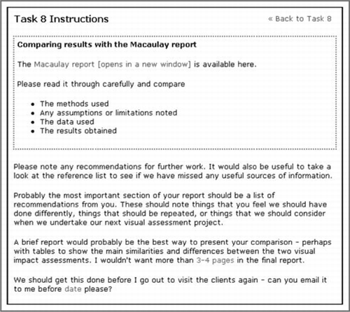
The student has 8 tasks to complete which include the selection and preparation of data; design, implementation and documentation of visibility analysis for the proposed Nant Carfan development; and preparation of a final report (). Each task requires the production of a ‘product’ (for instance a report, map or completed questionnaire) which is submitted by email to a member of the Virtual Geo-Consultancy. An example of the instructions for one of the tasks is provided in . The tutor (or another chosen individual) receives submitted products, which enables them to monitor progress or conduct assessment. Student work is also stored in a ‘virtual portfolio’. The tutor can control certain elements of the placement, for example submission dates, when details of tasks are released and the contents of a ‘virtual boxfile’ containing additional resources.
Table 1 Nant Carfan Virtual Placement
Figure 1 The Virtual Geo-Consultancy home page
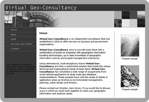
Figure 2 Instructions for Virtual Placement Task 8
Testing of the first version of the placement suggested that it would take about 48 hours of student effort. Several options for implementation were identified:
as a problem based learning activity in a course on geosciences
as a stand alone work placement experience (an alternative to an external work placement)
before or after a traditional work placement
as an individual or group activity.
Experiences with the Nant Carfan Virtual Placement
The MSc in Geoinformation Technology & Cartography at the University of Glasgow is a postgraduate programme focusing on understanding and managing the spatial data underpinning GIS. Map production and visualisation in a GIS environment are important components of the course, and a problem solving approach is adopted. The programme is designed for those with little or no academic background in geomatics or GIS and for those with technical and practical experience who require an academic qualification.
When the course was being designed the value of a work placement was discussed, but including such an opportunity was rejected for a variety of reasons (CitationForrest et al., 2005):
The wide range of learners’ backgrounds — some have no background in GIS or maps. For some learners it could be late on in the programme before they had developed sufficient skills to be of value to employers.
Fitting the placement into a programme of other classes — 1–2 days a weeks on placement was suggested but would be problematic, not least because of the need for locally based employment opportunities
The model preferred by employers was a 2–3 month placement — this would not be feasible until the end of the course and accommodating such a period within an 8 month course was problematic
The large anticipated numbers of overseas students for whom a compulsory placement might present visa, language and cultural problems.
As a result it was decided that work placement would not be formally included in the course, but students would be encouraged to carry out diploma or MSc projects in conjunction with employers. One of the courses in the programme, ‘Issues in Cartography and Geographic Information Science’, runs during the second term his course consists of 50-hour study units, many of which rely heavily on student-centred learning. This course has also been structured to provide the opportunity to use expertise outside the normal academic staff of the department.
The Virtual Placement appeared to provide an ideal opportunity to include a work placement element and an e-learning experience. It also fitted into the overall structure of the ‘Issues’ course as a stand-alone study unit, with the estimated 48 hours needed to complete it fitting well with the pattern of 50 hour study units. Thus, the Virtual Placement was offered to students on the 2004–5 cohort.
To complete the Issues course, students were required to undertake six study units from ten, making their choices based on brief descriptions of what each unit covers. The Virtual Placement was selected by 5 students. They were given a very brief introduction to what was expected, the key organisational issues and the web address and password to access the Virtual Placement, but were essentially left to find out about it from the included documentation. The intention was that the Virtual Placement would run with minimum supervision or intervention by staff.
Before embarking on the Virtual Placement all students had completed a 15 credit GIS course in the first term and were familiar with ArcGIS and accessing data from Digimap. Most had additional GIS experience from other first term courses or prior experience.
Four members of teaching staff were allocated the roles of staff in the Virtual Geo-Consultancy company so that student emails would be directed to people with appropriate expertise. None of the staff had completed the Virtual Placement task before the start of the course, but all were familiar with and supportive of the concept and agreed to take part in this way. One member of staff was overall placement tutor and controlled the release of tasks, set submission dates and generally checked on progress. Staff hours were not recorded, but overall were not very large and in future offerings the time commitment will be reduced due to experience gained.
Little guidance was available to the placement tutor about setting suitable submission dates, partly due to the flexibility offered in how the placement is run. The original plan was to run the placement over 7–8 weeks, but this had to be extended by several weeks. The different nature of tasks and anticipated completion times suggested made it difficult to set a regular timetable of submissions. This was made more problematic by having to deal with both full and part-time students. In practice, students took significantly longer to complete some tasks than anticipated and submission dates for tasks were revised several times. However, timely submission was a general issue with this particular class and improved overall timetabling across the programme based on this year’s experience would help minimise such problems.
Two questionnaires at the end of the placement provide a substantial amount of feedback on users’ experiences. One questionnaire requires reflection on the personal development that has occurred as a result of using the placement. The second is an evaluation of various aspects of the placement. Due to the small number of participants on the placement trial, statistical analysis of results is not appropriate., However, comments made by students provide an interesting insight into how they felt about the experience.
On the personal development questionnaire, participants are asked to comment on the development of person-, course- and job-related skills. Some of the feedback indicates that these skills are indeed enhanced by the placement.
Person-related skills
“This exercise [has] given me an idea to think about any problem before starting.”
“It was very useful to see the Macaulay report and look back to how I could have done mine better, not just specifically but in terms of wider issues such as presentation, which I could have improved upon.”
“I can now be more innovative and think more and more about GIS analysis. I can now … perform work independently.
Course-related skills
“Help[ed] me to understand ArcGIS and actual work placement complexities.”
“It was very useful to get some more experience of using ArcGIS extensively in a simulated working environment, with the communication and problem-solving issues that involved.”
“Initially I used to struggle at the time of any GIS project analysis. But using all the methods and examples provided by virtual placements I am now able to work [on my own] initiative. I know most of the terminology and learned how to perform analysis. Lot of things are there in theory but after doing practically my doubts have cleared.”
Job-related skills
“The kind of coordination, everyone sharing, the way we divide our tasks help[ed] me to learn more about team work”
“It was very good in the amount of initiative that was required to solve problems, particularly where the instructions were not comprehensive.”
“I got more confidence in my subject.”
When asked about which of the areas they felt skills had developed in most the responses were:
“Person related as I found the importance of team work”
“Course-related I now have much more confidence using the software”
“In the area of GIS analysis — I can think now to perform about some analysis in any GIS problem”
However, the running of the placement was not without problems. Technical difficulties occurred with the downloading of data and incompatible data formats, and the size of the data set used for the analysis. There were also challenges for students as they had to work with instructions written for an earlier version of the GIS software than they were using. However, these problems were overcome or could be easily addressed in any revision of the Virtual Placement.
Another problem was with email communications. One student commented on difficulties and delays in receiving responses, and the tutor also had problems with email communication. Again, this is largely a technical issue which can be resolved, although there is a human element to the problem as it requires monitoring and response from the tutor to keep the momentum of the project going.
Perhaps more important the placement took students significantly longer to complete than anticipated. One student estimated that they had taken 100 hours. In addition, perhaps due to the workload, a couple of students dropped out of the unit. The workload might be reduced if technical problems could be resolved, as students would then have spent less time on the aspects of the placement where problems occurred. However, such a project does clearly represent a significant commitment in terms of student effort.
Towards wider adoption and further development
The Virtual Placement has been developed and tested with one small group of students. Feedback suggests that it could be a useful alternative, or supplement, to the traditional work placement and that further development would be worthwhile. The next step is to raise awareness of its existence and seek support for updating, further development and dissemination. We would like to receive input from potential users and would be grateful for your feedback and comments on the questions below:
Do you see opportunities for the integration of this wind farm placement in your own teaching?
Would you like to help to develop and update the resources (for example, so that the activities can be used with different software products)?
Do you see opportunities for the development of other placement topics?
Would you like to be involved in developments, perhaps by contibuting to a new placement topic?
Would you be interested in an ‘empty placement shell’ into which you could load your own placement example?
If you have any comments or suggestions, please contact one of the paper’s authors by email.
Acknowledgements
The Virtual Placement was developed with help from a large group of e-MapScholar project members funded by JISC Learning and Teaching Project 5/99 and with support from the Macaulay Institute, Aberdeen. Amelia Pickering and William Mackaness deserve special mention. Thanks are also due to the students from the University of Glasgow who took part in the placement trial.
References
- BrownK. (2004) Employability of Geography Graduates in the GIS and GI-related fields. Planet 13 pp. 18-19
- ForrestD., CorneliusS., ElcockA. (2005) Experiences with a Virtual Placement. Proceedings FIG Working Week 2005 and GDSI 8, paper WSVA4.
- ShepherdI. D. H. (1998) How long is Short?: principles and practice in the delivery of work experience in geography. Arena Symposium. Journal of Geography in Higher Education. Vol. 22 no. 1 pp. 111-119