Summary
This article summarises the key outcomes from the conference on “Supporting Fieldwork Using Information Technology” held at the University of Plymouth in May 2006, which featured a wide range of presentations and demonstrations outlining the various technologies which are currently applied to fieldwork in the GEES subject areas.
Introduction
The “Supporting Fieldwork Using Information Technology” conference was co-hosted by the Centre for Excellence in Teaching and Learning (CETL) in Experiential Learning in Natural and Environmental Sciences and the GEES Subject Centre, with the key aim of exploring the ways in which innovative technologies could be harnessed by practitioners in Higher Education (HE) in order to:
Enhance students’ preparedness for fieldwork
Gain remote access to crucial information whilst in the field
Record field phenomena in more sophisticated ways
Challenge students in post-fieldwork assessment
It is anticipated that a better knowledge of the pedagogical value of IT in fieldwork will benefit the work of the CETL, and will also be of value to the wider HE community by increasing awareness and understanding of how and why certain technologies facilitate the learning process.
As a follow-up exercise to the conference, delegates were asked to complete an online survey designed to capture information relating to their current experiences of using Information Technology (IT) in fieldwork, together with their thoughts and ideas for future development. The first section of the following overview summarises the key points arising from the oral presentations, whilst in the subsequent section the key findings of the survey are integrated with the main themes emerging from the presentations. These then form the basis for discussion about the current trends, drivers and barriers to this emerging area of pedagogy.
Conference Presentations
The “Supporting Fieldwork Using Information Technology” conference featured nine oral presentations, together with a number of posters and demonstrations. The abstracts, together with some PowerPoint slides, can be viewed on the GEES Subject Centre website at http://www.gees.ac.uk/projtheme/cetls/el/fwitconf06.htm
Keynote: ‘E-Learning in the GEES disciplines: Results and examples from a practitioner survey in the UK’ — Derek France, University of Chester ([email protected]) and Steve Fletcher, Southampton Solent University ([email protected])
This talk provided an overview of the current role of IT within field-based learning environments, together with the main challenges and benefits faced by users. Real-time feedback from the audience gathered using “Communi-cubes” was broadly consistent with the results from previous surveys into the use of IT in fieldwork (e.g. the ‘Fieldwork, Education and Technology’ study of CitationFletcher et al. (2003) and subsequent surveys on elearning and Virtual Learning Environments (VLEs)). Discussion was supported by two very interesting case studies where IT has been used by the authors:
A ‘Virtual Field Course’ (VFC) to the Cromarty Firth (CitationFletcher, 2003)
The assessment of fieldwork using student websites (CitationFrance & Ribchester, 2004)
‘Towards a generic on-line fieldwork and laboratory environment’ — Phil Marston, University of Aberdeen ([email protected])
A project is currently underway to develop virtual learning environments specifically aimed at delivering realistic simulations of field visits and laboratory exercises for campus based students (for further information see http://www.abdn.ac.uk/diss/ltu/pmarston/). The ‘Virtual Environments Shell’ can be used to present a variety of spatially related materials and data, whilst the Virtual Zoology Laboratory generates personalised datasets and incorporates a built-in capability for ‘human error’.
‘From pencils and paper to laptops and lasers, the role of IT in earth science teaching’ — Phill Clegg, University of Durham ([email protected])
A proliferation of new technologies has enabled mapping of the natural world to become increasingly effective, and the application of these technologies is enabling students to better understand geological maps and visualise landscapes in 3D, e.g. via improved field observations and analysis. The advantages and disadvantages of digital geological mapping tools such as Geographic Information Systems (GIS), Digital Elevation Models and Light Detection and Ranging were outlined, together with the main barriers to uptake (e.g. cost, reliability and training) although these are generally considered to be resolvable.
Keynote: ‘Mobile technology in fieldwork and flexible learning: gadgets, pilots and horizons’ — Kenny Lynch, University of Gloucestershire ([email protected])
This presentation provided an overview of current use of mobile technologies in fieldwork (‘gadgets’) and the opportunities these present for increased flexibility in learning. Two examples (‘pilots’) of the use of mobile technologies based on the authors’ own teaching experience were given, together with the barriers that were encountered. Finally, the ways in which this area of technological development could be utilised to enhance learning in the future (‘horizons’) were explored.
‘Taking GIS-based 3D Visualisation into the Field’ — Gary Priestnall, University of Nottingham ([email protected])
This talk focused on the role of mapping and digital rendering technologies to enable 3D landscape visualisation whilst in the field and the lab. The use of Personal Digital Assistants (PDAs) and tablet computers in the field allows students to visualise specific features such as underlying geology, which can then be compared with the actual landscape. These mobile technologies are now being complemented with ‘augmented and virtual reality’ systems which ‘immerse’ the user in a computer generated landscape to support spatial thinking.
‘The Tamar GIS Project: bringing datasets together so that value-added activities can be undertaken’ — Samantha Lavender, University of Plymouth ([email protected])
A project is currently underway to develop a GIS database of the River Tamar catchment, which will bring together a range of information including base maps (Ordnance Survey & aerial photos), agriculture, ecology, forestry, history, hydrology, and industry (for further information see http://www.research.plymouth.ac.uk/geomatics/). This database could potentially be used as a resource to support interdisciplinary field activities across a range of subject areas.
‘Assessment — everything comes down to assessment…’ — Brian Whalley, Queen’s University Belfast ([email protected])
A range of technological ‘ideas’ designed to aid student data gathering, assessment and feedback were discussed, including:
Virtorial - structuring a tutorial-type process through tasks and information which can be fieldwork related;
Podcasts for landscape analysis - create your own reusable educational objects and provide feedback;
Geocaching - student guided rambling around a field site to gather data for lab use and assessment;
Webfolios — a means for student to display and reflect upon their practical work which can be assessed easily and linked with Personal Development Planning (PDP).
‘E-learning for fieldwork: learning design, standards and interoperability’ — Eduardo Serafin, University of Edinburgh ([email protected])
An innovative, web-based learning system is being developed to support a physical geography field course in Iceland, using Extensible Mark-up Language (XML) topic maps and Information Management System (IMS) learning design to design a ‘schema-based’ content (for further information see http://www.geos.ed.ac.uk/undergraduate/elf). Using this approach, website content can be separated from the style and delivery technology, leading to an improvement in searching and managing data. Further, it is anticipated that the software could be readily modified to accommodate the annual improvements and changes inherent to any field course.
‘Are virtual fieldtrips a substitute for the real thing?’ — John Spicer, University of Plymouth ([email protected])
Results from a study into the use of a hypermedia package on Tide Pool Ecology revealed there were no academic differences between students who were being taught in traditional lectures compared to students who were being taught with Virtual Field Trips (VFTs) (CitationSpicer and Stratford, 2001). From the study it was concluded that, while increased use of VFTs in particular was perceived as a positive and exciting prospect by biology undergraduates, they were also quite clear that this should not be at the expense of real fieldwork.
Results of online survey
The post-conference survey generated a response rate of 21% (n=22) from conference delegates. In addition to the GEES disciplines responses were received from academic staff in ocean science and civil engineering, and also from technicians, learning technologists and library staff. Following is a brief summary of the key points relating to questions addressing current and future use of IT:
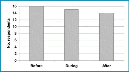
If you currently use IT in fieldwork, at which point do you use it?
Roughly equal numbers reported using IT before, during, and after fieldwork ().
Figure 1 Timing of IT use in relation to fieldwork
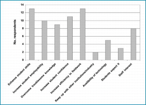
What are your main reasons for using IT in fieldwork?
The enhancement of student skills, increased efficiency, and increased student confidence were all cited by at least half of the respondents as being their main reason for using IT in fieldwork (). Student employability and overcoming troublesome knowledge are also popular reasons for using IT, although over a third indicated that staff interest had an influence.
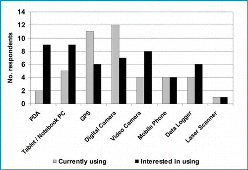
If you are currently using IT during fieldwork, what types do you use? What other types of IT would you be interested in using during fieldwork?
Whilst the most popular technologies currently used in fieldwork are digital cameras and Global Positioning Systems (GPS), respondents indicated a significant interest in using PDAs and tablet/notebook PCs, with a degree of interest in using video cameras ().
If you have previously used IT in fieldwork what types of problem have you encountered? How have these been overcome?
The two main problems encountered with using IT in fieldwork relate to:
hardware issues, particularly field reliability and portability;
ensuring that students and staff are familiar enough with the technology.
To solve these problems, staff relied on a variety of strategies:
purchasing ‘ruggedised’ equipment or protective housings;
carrying spare batteries and chargers;
using more basic technology;
developing user friendly software;
training for staff and pre-fieldwork sessions for students.
What are your future plans, if any, concerning the use of IT in fieldwork? How do you think this will benefit your students?
A significant proportion of responses to this question focused on the application of IT in field teaching, e.g.:
“I plan to use more video footage of people presenting as a tool for improving teaching in fieldwork by reflecting on delivery and structure”
“To use IT as a mainstream teaching and learning medium within Earth Science”
“[to explore] the use of [a tablet PC, data loggers and GPS] within teaching over the next 12–18 months”
The main benefits to students would be the development of transferable skills (including those associated with IT use), and the ability to analyse and interpret data. Methods of, and skills in, 3-D visualisation were also mentioned both in terms of future plans and student benefits.
Conclusions
As these findings have built on previous research undertaken by CitationFletcher et al (2002), it is appropriate that we should pose some of the same questions addressed by the expert group of the Fieldwork, Education and Technology (FEeT) study.
Figure 2 Main reasons for using IT in fieldwork
What are the central trends in the use of IT in fieldwork?
A key trend identified by the FEet study was widespread use of the web, especially as a platform for pre-fieldwork preparation materials. Whilst this is still prevalent, emphasis is now also being placed on careful design of such software to maximise ease of updating, modification and repurposing.
Other trends identified in 2002 included the use of a wider range of multimedia and virtual environments together with visualisation tools. Integration of data in the field was found to be occurring at a great extent and the use of mobile phones and GPS were noted as important in the development in field mapping projects (CitationFletcher et al 2002). Whilst these developments are still continuing, it is clear that since this time, the potential and demand for integration of data in the field has progressed significantly. This is due to the greater availability and affordability of mobile devices such as PDAs and tablet PCs and their role in acquiring and visualising GIS and other forms of data. Use of portable audio (MP3) and video technologies has also increased for recording and presenting field information and data.
What central factors are driving the integration of C&IT in fieldwork?
Several factors identified by the FEeT study are still relevant, particularly the widespread availability of technology and its falling costs. However, their observation that (in 2002) ‘no institutions represented at the meeting or in the survey were yet using palmtop computers’ is a telling one. We have since witnessed a significant advance in the capabilities of mobile devices especially in relation to their portability, memory capacity, robustness and flexibility. These attributes, combined with the proliferation of wireless networks and the increasing availability of online digital resources allow new approaches to learning in the field environment. Another new theme to emerge at this conference was the increased technological awareness and indeed expectations of the current generation of students, although this did not feature in the survey as a dominant driver.
The inherent tension between pedagogic and technological drivers within fieldwork and IT has not gone away and featured as a subtext in most presentations. Nevertheless, the dominant opinion is still that outlined by CitationFletcher et al. (2002) that “Care has to be taken that the driving force is not totally technology led, but the use of IT has definite pedagogic benefits”. Survey results indicate that the dominant reasons for using IT in fieldwork are associated with pedagogy and increasing efficiency rather than the availability of technology.
Figure 3 Use of IT tools during fieldwork
What central factors are hindering the integration of C&IT in fieldwork?
Increasing use of mobile devices in the field environment has led to more staff experiencing their shortcomings. Technology issues most commonly encountered relate to ruggedness, reliability and usability, whilst cost of hardware and digital data was also mentioned. Another major issue is the requirement for staff and students to familiarise themselves with the technology through training or preparation sessions. This is essential so that the development of IT skills (which can be an important outcome) does not become the dominant learning activity whilst students are actually in the field. There is also a risk that certain uses of IT in the field could become ‘discipline specific’ when in reality, and as this conference has demonstrated, there is great potential for their application in other subject areas.
References
- FletcherS., FranceD., MooreK. and RobinsonG. (2002) Fieldwork Education and Technology: A GEES Perspective. Planet 4: pp. 17-19
- FletcherS. (2003) Integrating a VLE into classroom teaching: a virtual fieldtrip to Cromarty Firth. Proceedings of a one day conference on Virtual Learning Environments in Geography, Earth and Environmental Sciences, Univeristy of Birmingham, November 2003http://www.gees.ac.uk/events/2003/vle03/sfletcher.ppt
- FletcherS., FranceD., MooreK. and RobinsonG. (2003) Technology before pedagogy? A GEES C&IT perspective. Planet Special Edition 5: pp. 52-55
- FranceD. and RibchesterC. (2004) Producing websites for assessment: a case study from a level 1 field work module. Journal of Geography in Higher Education28: pp. 49-62
- SpicerJ.I. and StratfordJ. (2001) Student perceptions of a virtual field trip to replace a real field trip. Journal of Computer Assisted Learning 17 345-354