Abstract
Google Earth is a web-based virtual globe that has seen increasing use over the past five years as a teaching tool and learning resource for geography, earth and environmental science students. This paper explores some of the potential uses of Google Earth in sustainable development education, and assesses its value for staff and students. Over a two year period, different projects were devised that required undergraduate students to engage with Google Earth and reflect on its value. The projects included a final year investigation into climate change in northern Africa which was also used as a learning resource for postgraduate students, a project to assist disaster response coordination following the earthquake in Haiti in 2010, and a first year exploration of development issues in a variety of locations in the global South. The findings of the research highlight the variety of uses of Google Earth in both physical and human geography, both as a teaching tool and a learning resource. It has great potential to raise awareness of places, issues and technology, to inspire investigation and learning, and enhance understanding of global issues including climate change.
Introduction
Google Earth is a web-based virtual globe that is freely available to download from the Internet. It provides satellite images and Geographic Information System functions including measuring, layering, image interpretation, and place marking that are relatively easy to use. The use of Google Earth has become increasingly widespread, with considerable application of the technology in business and industry, as well as at secondary school level (CitationHaslett et al., 2010). In Higher Education, CitationHaslett (2009) identifies that Google Earth is being used successfully in studies related to health, planning, tourism, water technology, biodiversity, archaeology and urban development. Despite this, overall take up of Google Earth at Higher Education (HE) level has been relatively slow (CitationHaslett, 2009), therefore providing one of the stimuli for this project.
This project has been funded by the Higher Education Academy Subject Centre for Geography, Earth and Environmental Sciences (HEA-GEES) and involves collaboration between staff at Bath Spa University and the University of Wales, Newport. The project aimed to explore current use of Google Earth in sustainable development education, to develop new blended learning examples and monitor student engagement, and to suggest further developments for its future use in diverse curricula. This paper provides an overview of the learning activities evaluated for this project and discusses their value for staff and students.
Methodology
The learning activities were chosen to enable evaluation of Google Earth at different levels of study and for different topics within the area of sustainable development.
At Level 4, Google Earth was introduced in a research report in a development geography module
At Level 6, a more advanced application of Google Earth was incorporated into a project exploring climate change in West Africa. This was then developed into a learning resource for postgraduate students studying MA Education for Sustainable Development and Global Citizenship
Level 5 and 6 students were involved in a project to assist disaster response coordination in Haiti after the earthquake in January 2010
After completion of the first two activities, students were invited to complete a questionnaire survey that collected information about prior use of Google Earth, ease and enjoyment of current use, value of specific features of the application, enhancement of geographical skills or knowledge, and potential future value for the students’ studies, fieldwork or for other modules. Seventy seven surveys were completed during the project timeframe, with respondents from the different activities each completing the same questionnaire to enable comparability of responses. The information collected was predominantly quantitative, therefore easing collation. However, qualitative data was also collected in order to more fully understand students’ experiences of Google Earth. Following use of the climate change learning resource, the postgraduate students provided more qualitative responses to questions regarding the value of the resource to the topic of climate change and sustainable development. More anecdotal evidence was collected regarding the value of the disaster response project due to the small numbers of students involved and the timing of the project.
Example 1: Introduction to Development Geography
The Level 4 activity was a significant component of an introductory development geography module that aimed to explore key development theories, concepts, institutions and realities of development practice. As an introductory module, there were a variety of students enrolled, including those not studying geography as their main subject, with a range of different academic backgrounds, skills levels, and familiarity with software packages. For this activity, the students were tasked to ‘use the Internet and Google Earth to devise a project on a development geography topic’. After initial training on the basic features and tools of Google Earth, the students were required to use it to identify and explore their chosen research location and to help them to devise a hypothetical research project that would be relevant in the specific area. Each student devised their own project with one-to-one support available from the tutor. At this introductory level, the value of Google Earth was that it enabled the students to develop a more informed understanding of their chosen location and to identify possible development issues, made visible through interpretation of the images available. These could include risks of flooding and the aftermath of natural disasters, issues of quality and quantity of housing infrastructure, soil quality and water scarcity, deforestation and desertification, and effects of urbanisation processes.
The survey information showed a positive response from the students in terms of both the ease of use of the software, and the improvement in skills and knowledge that they gained as a result. While the number of surveys completed was small (n=11), all of the students found the basic functions easy to use and 82% enjoyed using Google Earth. Comments from the students included the value of “being able to see real images from places”, and that it was “easy to zoom in and find information”. All students thought that using the software had improved their awareness of geographical skills and 82% found it easier to visualise and interpret landscapes using Google Earth rather than through the use of traditional maps. The same percentage felt that using Google Earth had enhanced their understanding of the topic, and 91% thought that Google Earth would be useful in their future study, research and fieldwork. The few students who were less positive about Google Earth reported problems with some of the functions, particularly using different layers and changing the angle of view or zooming in effectively. It is therefore likely that more training in the use of Google Earth functions would improve their experience. The enhanced understanding of the places and the potential issues was evident from the comments given: “[Google Earth] gave a clear indication of how isolated the place was”, while another commented that it “showed limited infrastructure… Roads and houses were of poor quality”. Another student commented that “Google Earth is a useful tool to help and support studies and gain awareness of a[n] area or place before you visit or conduct research”. These findings raise interesting questions about the potentially greater engagement of students using Google Earth compared to the use of more traditional and perhaps less accessible GIS software packages and paper-based maps.
Example 2: Climate change and sustainable development
For a Level 6 practical delivered over two weeks this study was developed to examine the links between palaeoclimate research, present climate change impacts, and sustainable development issues.
The practical involved examining proxy data, in the form of geochemical samples from an ocean core site located offshore of Mauritania, western North Africa (Ocean Drilling Program site 658). The geochemical data, specifically aluminium, represents the input from dust transported by Aeolian processes offshore from the Sahara/Sahel.
A number of questions were asked on the basis of these data:
Identify any major palaeoclimate cycles/events present or absent (i.e. Heinrick Events, LGM, Bond Cycles, Dansgaard-Oeschger Events)
Is there any relationship between palaeoclimate and dust input?
What is the implication of this palaeoclimate research for understanding modern climate change impacts?
The investigation then utilised Google Earth to ‘fly over’ the modern landscape of Mauritania, focusing on the eastern margins of Nouakachott. Using this resource the following questions were investigated:
Describe the condition of the urban-desert margin
Interpret the current dynamic status of the urban- desert margin
Is there a link between the modern landscape and climate change?
Is there any evidence that measures have been deployed to enhance the sustainable development of the area?
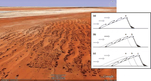
Conclusions could be drawn in relation to the encroachment of the desert into the urban regions, while links could be made from the geomorphological processes to sustainable development to prevent the encroachment. CitationHaslett et al. (2010) show, using Google Earth images, that sand is inundating the streets of Nouakchott, resulting in the abandonment of some dwellings. Images also show that environmental management practices are being deployed to the east of the city in an attempt to slow the westward sand dune migration. These practices include the planting of gridded networks of Prosopis bushes and the erection of Leptadenia fences to trap and stabilise mobile sand.
Figure 1: Screen shot taken from Google Earth of eastern margins of Nouakchott, illustrating sustainable planting regimes, with inset diagram of dune processes. Source Google Earth (2010) and CitationHaslett (2008).
In general, from both the results of the survey () and anecdotal evidence through conversations with students, a large benefit can be gained using Google Earth. A number of the less able ICT students had previous exposure to more specialist GIS software and were put off by the experience. These students really engaged and saw the benefits of using the visualisation and simple analysis of Google Earth. A number even developed its use for dissertation projects where they would not have done with the specialist GIS software.
This practical exercise has been further developed into an e-Research online publication The Sands of Time (CitationHaslett and Savage, 2009; CitationChillcott and Haslett, 2010), which has been piloted as a learning resource with postgraduate students studying MA Education for Sustainable Development and Global Citizenship (ESDGC) at the University of Wales, Newport. The students on this course are part-time and the majority are employed as Further Education College lecturers. These students were asked three questions elating to their use of this online learning resource and the results shown in . The results indicate that the resource provides an example of how Google Earth may be used to assist students in visualising climate change impacts, and considering impacts of which they had previously been unaware. Some responses also indicate that ideas for new case studies were prompted by the resource that some of them will use in their own teaching.
Table 1: Results of the student survey following the exercise.
Table 2: Responses to The Sands of Time resource from MA ESDGC students.
Example 3: Helping Haiti
A further example of Google Earth use materialised unexpectedly in January 2010 following the magnitude 7.0 earthquake that struck Port Au Prince, Haiti.
Bath Spa University were contacted by ImageCat Inc. who had been tasked with developing the Global Earth Observation Catastrophe Assessment Network (GEO-CAN) to assess damage due to this event. This work was carried out on behalf of the World Bank and the Global Facility for Disaster Reduction and Recovery (GFDRR). ImageCat contacted a network of academic institutions and geomatics companies to act as damage assessors. GEO-CAN Participants form a global network representing 131 organisations from 23 countries around the world, including: 60 universities; 18 government and non-profit organisations; and 53 private companies. As of Febuary 2010, GEOCAN consisted of over 600 individuals and was still growing.
Only students with previous experience of GIS and specifically image interpretation were requested. Comprehensive instructions as to what was required along with pre- and post-earthquake images in Google Earth format were sent to participants, such as which displays collapsed structures in Port Au Prince.
Figure 2: Collapsed structures, Port Au Prince. Image source Google Earth, 2010, data source: GEO-CAN Network 2010.
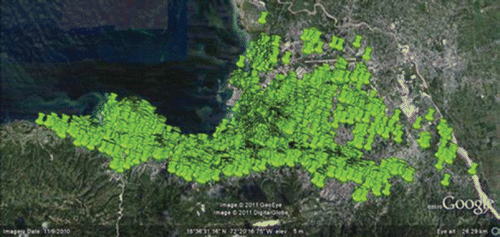
, detailing the point locations of collapsed structures, formed the first phase of this project and was completed within 48 hours of the incident. The student involvement from Bath Spa University formed phase 2.
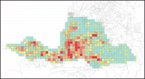
Each person was issued with a username and password to log in to a website and download a specific 0.5 × 0.5 km grid tile of an area for damage assessment. The participant could then switch between images and digitise the building footprint and assign a damage assessment category to the buildings. When complete the finished Google Earth file was uploaded to the website and another downloaded. The data were then compiled into a summary dataset for use by the World Bank, as in .
Figure 3: Number of collapsed structures per 0.5km × 0.5km tile. Source: ImageCat 2010.
This example of Google Earth usage did not form part of the student survey which took place in the months prior to the event. Also, it was only taken up by a small number of students with good knowledge and understanding of GIS. It is planned to develop this example as a case study for use in the future to a wider population of students.
Such an example provides the students with real life experience of applications of image interpretation and simple GIS analysis. The experience places into context some of the basic skills and how these can utilised. Anecdotal evidence suggests the students felt empowered that the skills they were learning could aid in such a significant way to a relief effort.
Conclusion
The activities developed here highlight the value of using Google Earth at a range of levels and in a variety of tasks, from simple introductory exercises, to more complex and demanding blended learning activities. Overall, from these activities, the value of Google Earth can be seen in three key areas. Firstly, Google Earth can play a vital role in raising awareness of, and interest in, distant places that many students are unlikely to have visited, or will visit in the future. Secondly, following this greater awareness, potential development and sustainability issues can be highlighted and explored through further study. In this way, Google Earth can help to raise questions about the reality of places, and combined with relevant further investigation, can help to encourage critical thinking about processes and effects. This can be related to a range of processes, from poverty alleviation and international development, to climate change, geological activity and natural hazard response. However, it is important to emphasise that basic image interpretation of sustainable development issues must be accompanied by more in-depth reading and thinking about the processes of development and the complexity of the reality of places. Thirdly, these activities show that Google Earth can be used as a tool to enable more applied learning, as it can help to put the learning of key theories and concepts from textbooks into a more understandable real-world context. In this way, the students gain a greater sense of engagement with the topics, and become more empowered through the application of the knowledge learnt and skills obtained.
Acknowledgements
This research was funded through a Small-Scale Project Grant from the Higher Education Academy Subject Centre for Geography, Earth and Environmental Sciences, and administered by the Centre for Excellence in Learning and Teaching at the University of Wales, Newport. Thanks to undergraduate students at Bath Spa University who participated in the survey, and to participants at an HEA-GEES conference in July 2010, where this paper was first presented.
References
- ChilcottM. and HaslettS. K. 2010 Climate change and sustainable development education through the lens of Google Earth, Teaching Earth Sciences, 35, 20-23
- HaslettS. K. 2008 Coastal Systems, Routledge, London
- HaslettS. K. 2009 Prior use of Google Earth by undergraduate Geography students, Planet, 22, 43-47
- HaslettS. K. and SavageN. 2009 The Sands of Time: A Google Earth Approach to Climate Change Education, University of Wales, Newport http://idl.newport.ac.uk/celt/sandsoftime/ Accessed 14 June 2012
- HaslettS. K., SkellernA., ChilcottM. and LongmanD. 2010 Climate change education through a blended learning Google Earth exercise. In HaslettS. K., FranceD. and GedyeS. (Eds.) Pedagogy of Climate Change, Higher Education Academy, York, 112-127
- ImageCat 2010 World Bank/GFDRR/ImageCat/RIT Remote Sensing and Damage Assessment Mission Haiti, January 2010
- http://www.eqclearinghouse.org/20100112-haiti/wp-content/uploads/2010/02/ImageCat-Haiti-EQ-Project-Sheet-EERI-20100209.pdf Accessed 14 June 2012