Abstract
Remote sensing is known as a technique providing the world with diversified imagery on different scales. Meanwhile, these images are an inherent part of newspapers, TV news and various online sources used to communicate information. Being — somehow — omnipresent, remotely sensed images are also interesting sources for education.
This contribution presents two examples of how satellite and aerial images can be used to teach foreign languages. The first example refers to the teaching of English in primary schools, whilst the second example concerns the Irish language taught at the Ruhr-University Bochum (RUB), Germany.
Introduction
Remote sensing is widely known as a method to observe the earth surface on different scales. Thus, the data and images produced by sensor systems are interesting sources for various science applications. In addition, remotely sensed images bear the potential of being used as teaching material in different educational applications (CitationNeumann-Mayer, 2005; CitationNaumann et al., 2009; CitationJürgens, 2003; CitationKarydas and Manakos, 2008; CitationSiegmund et al., 2008). In particular, digital and online resources can overcome local technological and infrastructural issues and help pupils and students to make progress in their studies — not affected by constraints on time and study locations (CitationUnderwood et al., 2008; CitationScherz and Oren, 2006). The CitationSEOS-project (2010), for instance, shows the opportunities for applying satellite images as well as aerial photographs to online geography, biology, physics and mathematics lessons designed for secondary schools. This paper, however, highlights the potential of linking extracted information from satellite and aerial imagery with sound (vocal narration of native speakers) to provide teachers and students/pupils with interesting learning/teaching material for the language classroom. Here, two examples are presented that have been designed in the Geography Department of the Ruhr-University Bochum (RUB), Germany. The first example concerns the teaching and learning of English in primary schools. The second example refers to the Irish language (Gaeilge) taught at RUB.
Example 1: English in primary schools
The remotely sensed imagery provided by Google is a valuable and freely accessible source covering most parts of the world’s topography. The capabilities of some web map client applications allow users to imbed Google’s image layers into web browser applications. Moreover, this technically imbedded visual base can be extended with ‘OpenLayers’, an open source JavaScript library, and thus be linked with sound data files.
In the context of the idea “LiFe-Mapping” (Linguistic Feature Mapping), a series of audio-visual maps have been designed for the teaching of English in German primary schools. These maps allow pupils to listen to the pronunciation of space-related vocabulary while dealing with (image) maps (CitationEdler and Lammert-Siepmann, 2012). The high spatial resolution and area coverage of the Google imagery make it possible to create digital learning/teaching material based upon the nearby geography/topography of most schools . The following example refers to a primary school in Bochum (Gertrudisschule Bochum-Wattenscheid) — a school in the ‘urban jungle’ of the Ruhr area.
Figure 1: “My School” in Bochum-Wattenscheid
(Source: Google Maps, GeoBasis-DE/BKG, AeroWest, Aerodata International Surveys, DigitalGlobe, GeoContent, GeoEye)
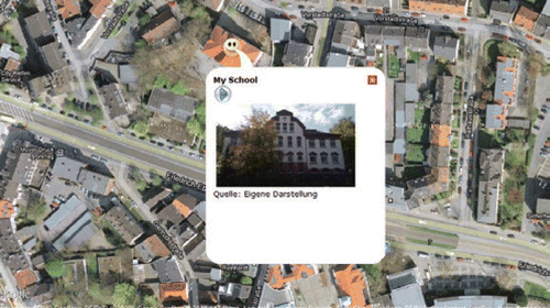
The example presented here (Figure 1) shows the actual school building. By looking at their school and its environment from above, the pupils — together with their classmates and teacher(s) — may identify some geospatial objects they are familiar with, such as buildings, roads and trees. Having identified the area, the pupils are asked to click on the smiley symbol to activate a pop-up including a frontal view of their school. In addition to this image, the pupils are now invited to click on the “play”-button. Now, the following spoken text recorded by a British native speaker can be heard: “This is my school. I am at school on Monday, Tuesday, Wednesday, Thursday and Friday. I am not at school on Saturday and Sunday.” Here, easy steps of image interpretation are combined with the sound of the foreign language. Additional pieces of vocabulary, such as the days of the week, are thematically as well as spatially linked with the image.
Apart from this brief example, teachers can be provided with an “editor” to create their own audio-visual teaching units. This editor allows them to mark their own points of interest (POIs) and to upload their own sounds and images linked to these POIs.
The technical framework of the application consists of open source products that do not require any fees for software licences. One of the main ideas behind the project is to provide every school with multimedia teaching/learning material referring to the environment of the school — in other words: referring to the familiar space of the children.
Example 2: Irish at (Bochum) University
While the case study described in example 1 is technically based on an open source web server application, the example presented here has been developed using the proprietary animation software Adobe Flash. Based on Flash, a tutorial comprising seven different units has been created in order to support beginner students of Irish in their learning of basics in pronunciation, intonation, vocabulary, grammar and orthography.
The first four units of the tutorial are based on audio-visual maps. In these maps, visual animations are combined with spoken text recorded by Irish native speakers. Thematically, the first unit shows how the number of speakers of the Irish language has been decreasing since the 12th century. The units two, three and four concern Ireland’s administrative structure, including the correct pronunciation of the names of Ireland’s provinces, counties and cities. The fifth unit comprises idioms about the weather, which is an inevitable topic of everyday conversation in and about Ireland. In unit five, the weather is linked to a thematic (sound) map. In the sixth unit, the user gets in touch with satellite image.
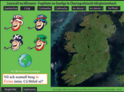
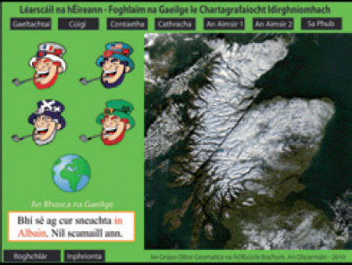
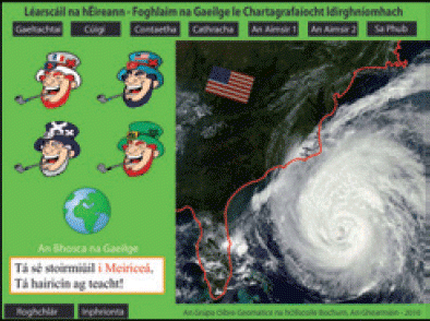
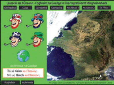
Here, radiometrically enhanced satellite images covering the landmass of different countries are to be watched and interpreted. This interpretation refers to the weather at the moment the images were taken. A cloud-free Ireland (), a snow-covered Scotland (), the hurricane-stricken East Coast of the United States () and a sunny and dry France () can be seen. In a further step, these weather states are connected with Irish words describing the weather.
The satellite imagery, which was acquired by NASA’s MODerate resolution Imaging Spectrometer (MODIS), is not only used to introduce/repeat vocabulary, but also to illustrate the initial consonant mutation (urú) as an important grammatical aspect of the Irish language. In contrast to France (An Fhrainc), for instance, the Irish terms for Ireland (Éire), Scotland (Albain) and the USA (Meiriceá) are not accompanied by a definite article. If they are combined with “i”/“in” (in), their preposition does therefore not turn into “sa” (“i” + definite article “an”) (, and ), whereas it does in combination with the countries standing in the definite form (). These grammatical peculiarities of Irish are furthermore highlighted by visual animations in red in the Irish text box of the application (“An Bhosca na Gaeilge”). Native speaker recordings — acoustic animations — make it possible to listen to the sentences displayed in the text box. The didactic structure of unit 6 is compiled in . The seventh unit includes a ‘virtual field trip’ to a pub in Kerry — technically, this unit is based on an audio-visual animation of a photorealistic 3D model.
Table 1: The Structure of the Application.
Remote sensing in the language classroom
The two examples from different language classrooms — primary school and university — show the interdisciplinary potential of “a key technology in our modern-day information society” (CitationVoss et al., 2009). Languages, especially the ‘lingua franca’ English, are becoming more and more important — so why not use the images obtained by airborne and spaceborne sensor systems for diversified language classes? “[T]hese images are not just pretty pictures” (CitationGreenberg et al., 1993) — they carry information we could use in many fields.
References
- EdlerD. and Lammert-SiepmannN. 2012 Audio-visuelle Karten für den Englischunterricht an Grundschulen. In Geographisches Institut der Ruhr-Universität Bochum (Ed.): Materialien zur Raumordnung, 75, 2. Bochum: European University Press
- GreenbergR., KolvoordR.A., MagisosM., StromR. and CroftS.K. 1993 Image Processing for Teaching, Journal of Science Education and Technology, 2, 469-480
- JürgensC. 2003 Geo-Fernerkundung — was ist das? Praxis Geographie, 33, 3, 4-7
- KarydasC. and ManakosI. 2008 Contributions of Geo-Informatics to Environmental Education: Demonstration of an Example from the Research, Proceedings of the International Conference on Energy Planning, Energy Saving, Environmental Education, CD-Rom, Corfu
- NaumannS., SiegmundA., DitterR., HaspelM., JahnM. and SiegmundA. 2009 Remote Sensing in School - Thereotical Concept and Practical Implementation, In KönigG. and LehmannH. (Eds.), E-Learning Tools, Techniques and Applications (Proceedings of the ISPRS working group VI/1-VI/2), CD-ROM, Potsdam and Berlin
- Neumann-MayerU. 2005 Der Zugang zu Satellitenbildern in der Orientierungsstufe, in Probleme und Möglichkeiten, Kiel University Press, Kiel
- ScherzZ. and OrenM. 2006 How to Change Students’ Images of Science and Technology, Science Education, 90, 965-985
- SEOS Project (Ed.) 2010 Tutorials, http://lms.seos-project.eu/learning_modules/ Accessed 11 June 2012
- SiegmundA., WolfA. and KollarI. 2008 Perspectives of Remote Sensing in Higher Education — A contribution for the training of the “spatial behaviour competence”, Proceedings of the EARSel Symposium Bolzano, CD-ROM, Bolzano, 573-580
- UnderwoodJ., SmithH., LuckinR. and FitzpatrickG. 2008 e-Science in the Classroom — Towards Viability, Computers and Education, 50, 535-546
- VossK., GoetzkeR., and HodamH. 2009 Learning Modules - A Way To Integrate Remote Sensing Methods in School Education, In KönigG. and LehmannH. (Eds.), E-Learning Tools, Techniques and Applications (Proceedings of the ISPRS working group VI/1-VI/2), CD-ROM, Potsdam and Berlin
