ABSTRACT
The altitudinal variation of precipitation, evapotranspiration, and runoff was quantified at 16 different grassland sites between 580 and 2550 m a.s.l. in the Austrian Alps. Along this altitudinal transect annual evapotranspiration decreased from roughly 690 mm at low elevation sites to 210–220 mm at the upper limit of the alpine grassland belt. A detailed analysis of the data showed that the observed reduction in the annual sum of evapotranspiration could be mainly explained by the altitudinal decline of the length of the snow-free period (i.e. the vegetation period). Daily mean sums of evapotranspiration showed no altitudinal trend and averaged 2.2 mm d−1 independent of elevation, although the leaf area index, growing season mean air temperature, and vapor pressure deficit declined with increasing altitude. As precipitation increased with elevation, evapotranspiration seems to be of secondary importance when compared to runoff. Inter-annual variability of evapotranspiration was fairly low across contrasting dry and wet years (coefficient of variation = 7%), indicating that even during dry years water availability was not limiting evapotranspiration.
Introduction
Grasslands are one of the most widespread vegetation types and cover approximately one-fifth of the earth's land surface (CitationHall and Scurlock, 1991). In the Austrian Alps a variety of grassland ecosystems such as meadows, pastures, alpine grass, and sedge mats cover approximately 40 to 45% of the total land area and extend from the valley floor to the upper limit of the alpine grassland belt at approximately 2600 m a.s.l. (CitationSchiechtl and Stern, 1974; CitationLaboratoire des Ecosystèmes Alpines, 1995). Altitudinal alterations in climate (CitationSchröter, 1926; CitationSteinhauser et al., 1960; CitationEllenberg, 1996; CitationFranz, 1979; CitationBaumgartner 1980, CitationFliri, 1975, CitationVeit 2002), edaphic parameters (CitationFranz, 1979), and land use (CitationCernusca et al., 1999) cause significant changes in species composition, biomass production, and canopy structure of grassland ecosystems in the Austrian Alps (CitationCernusca and Seeber, 1981).
The water balance of montane, subalpine, and alpine (sensu CitationEllenberg, 1996) grassland ecosystems is an important feature, especially in the Austrian Alps where precipitation exceeds the water use of vegetation and the storage capacity of soils. Vegetation is an important factor influencing the annual ecosystem water balance, which is determined by the water input through precipitation (P) which falls as rain, snow, or fog. Some of the P adheres on the above-ground vegetation and evaporates before reaching the ground—the so-called interception (I). The remaining P reaching the ground runs off (R
S, surface runoff), infiltrates into the soil, and percolates through to the water table (R
D, deep seepage), finally leaving the system as base flow. The amount of water which is held against gravitational forces within the soil matrix can be taken up by the plant roots and is finally transpired through the stomata of the leaves into the atmosphere (T, transpiration) and evaporates from the soil surface (E). So, over short periods, there are also changes in the soil water content (ΔW). All the components involved are given in mm ( = kg m−2 of slope parallel ground) and the complete water balance equation of an ecosystem reads:
In view of the fact that it is frequently very difficult to measure all the terms of EquationEq. 1
and taking into account that over long periods (an entire growing season or year) ΔW may be assumed to approach zero, the water balance equation (EquationEq. 1
) can be simplified to:
where ET is the sum of all water vapor fluxes from the system to the atmosphere (E + T + I), and R is the sum of deep seepage and surface runoff.
Earlier estimations of the annual water balance at different altitudes for the European Alps (CitationBaumgartner, 1980) included estimations of ET based on meteorological data (CitationMüller, 1965; CitationKern, 1975) or estimations of total R from catchment stream flow data (Steinhäusser, 1952, 1970). Since the mid 1980s, lysimeter studies (CitationKörner et al., 1978; CitationGuggenberger, 1980; CitationWieser ,1983; CitationScott et al., 2002), the Bowen-ratio method (CitationCernusca and Seeber, 1981; CitationStaudinger and Rott, 1981; CitationRosset et al., 2001), and the eddy covariance technique (CitationWohlfahrt, 2004; CitationHammerle et al., 2007) have also been used to measure ET for calculating the water balance of grassland ecosystems at various sites within the Austrian Alps.
The objective of this paper is to compile what is presently known about the water balance of grassland ecosystems in the Austrian Alps. We first examine the inter-annual and seasonal variability and the driving forces of ET using data from a long-term mountain grassland study in the Stubai valley. The following section deals with the altitudinal variation of ET, and finally we focus on how the overall water balance of grassland ecosystems changes with elevation.
Study Sites and Methods
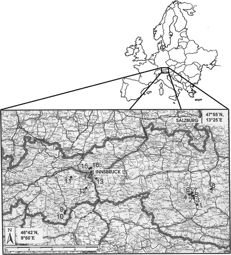
To characterize the effects of altitude on the various components of the water balance of grassland ecosystems we compare experimental data from 16 sites in the Austrian Alps between 580 and 2550 m a.s.l. The selected sites differ with respect to geographic location, altitude, exposition, and inclination () and include montane and subalpine meadows and pastures below the timberline and alpine grassland ecosystems above the alpine timberline, respectively. Eight sites (stations 1 to 8) were located in the Hohe Tauern mountain range in the southern part of the Austrian Alps. Five stations were in the inner Alpine sector, namely in the Ötztaler Alpen (station 9 and 10), the Stubaier Alpen (station 11 and 12), and the Tuxer Voralpen (station 13).In addition, there were also three stations situated along an altitudinal transect in the Northern limestone Alps (stations 14 to 16). shows the location of the 16 sites.
TABLE 1 General overview of the study sites.
FIGURE 1 Map showing the location of the study sites. Refer to for station numbers.
A common set of precipitation, ET and runoff measurements was acquired at each site. Precipitation was estimated with Hellmann rain gauges installed 2 m above ground and throughout the growing season also with rain gauges installed slope parallel close to the soil surface (CitationHenning, 1974). The latter are suggested to be more representative for P when focusing on the water availability of canopies during the snow-free period (CitationStigter, 1974). On average, growing season sums of P estimated slope parallel close to the soil surface were 6-11% higher than P values obtained by Hellmann rain gauges at 2 m above ground.
At all stations (see ) except station 12 (Neustift), ET and total runoff were measured by means of weighting and non-weighting “monolithic“ lysimeters (CitationCourtin and Bliss, 1971; CitationKörner et al., 1978; CitationWieser, 1983; CitationScott et al., 2002) sunk into the ground. The soil within the lysimeters was undisturbed, pores at the bottom of the lysimeter allowed drainage and forced all runoff into seepage. Evaporation from the snow surface was calculated using Sverdrup's formula of the sublimation of snow (CitationMüller, 1965). At the two sites in the Ötztaler Alpen and at Neustift, ET was quantified using micrometeorological methods (): At the two sites in the Ötztaler Alpen (station 9 and 10) the Bowen-ratio method (CitationStaudinger and Rott, 1981) was applied in addition to lysimeters; at the study site Neustift, (station 12) the eddy covariance technique was used for determining ET as described in CitationWohlfahrt (2004) and CitationHammerle et al. (2007). At Neustift, which is representative for the lower elevation grasslands of the investigated transects, ET has been measured since 2001 and this six-year data set will be used to analyze the inter-annual and seasonal variability, as well as the controls on daily ET.
Results and Discussion
Inter-Annual Variability, Seasonal Trends, and Driving Forces of Evapotranspiration
As shown in , daily ET at the low-elevation site Neustift was generally very small from January through March (0.05-0.15 mm d−1), when snow usually covers the ground. After snowmelt, evaporation rates quickly increased, reaching peak values of 4-5 mm d−1 during the period May-October, after which ET gradually declined back to wintertime values (). These peak evaporation rates are in good agreement with other studies on well-watered grassland ecosystems (e.g. CitationMeyers, 2001; CitationRosset et al., 2001; CitationTasser et al., 2001; CitationWever et al., 2002).
FIGURE 2 Inter-annual variability of cumulative evapotranspiration (left) and daily evapotranspiration (right) of a low-elevation mountain grassland (study site Neustift, 970 m a.s.l.).
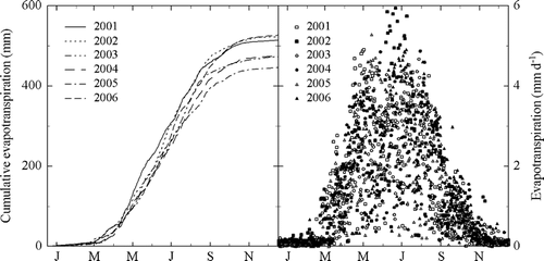
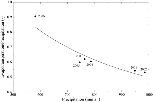
During 2001-2006, annual ET ranged from 446 mm (2005) to 527 mm (2006) (), or 53% (2002) to 91% (2006) of annual P, with coefficients of variation of 7 and 20%, respectively. The potential driving forces considered (global and net radiation, air and soil temperature, vapor pressure deficit, soil water content, and precipitation) explained little of this variability, the best predictor being air temperature, which in a linear regression explained 35% of the variability in annual ET (p = 0.11). Restricting the analysis to the vegetation period, where the majority of ET occurs (), improved regression statistics only slightly (data not shown). Once ET was normalized with precipitation, a statistically significant non-linear relationship was found with precipitation, shown in . There it can be seen that the fraction of precipitation evaporated to the atmosphere increased with decreasing precipitation and that this increase was asymmetric, i.e. ET increased disproportionately during years with little precipitation. We interpret this behavior as to indicate that even during dry years, when up to 90% of the precipitation is evaporated, no water stress occurs in these systems, but that in contrast, environmental conditions (higher evaporative demand, higher radiation input) lead to increased evaporation rates.
FIGURE 3 Annual evapotranspiration normalized with precipitation against precipitation for a low-elevation mountain grassland (study site Neustift, 970 m a.s.l.).
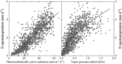
The largest fraction of variability in daily ET (excluding periods of snow cover) was explained by the amount of incident photosynthetically active radiation (; r 2 = 0.74, p = 0.00), followed by net radiation (data not shown; r 2 = 0.70, p = 0.00), which were though strongly correlated (r 2 = 0.92, p = 0.00). Similar correlations have also been observed for the two sites in the Ötztaler Alpen by CitationStaudinger and Rott (1981). This reflects the energy demand for the evaporation of water (CitationCampbell and Norman, 1998), as well as photosynthesis, which is linked to transpiration by stomatal conductance (CitationLarcher, 2001). The good predictive power of these two radiation forcings again indicates that limitations of transpiration by stomatal closure due to low soil water availability and/or dry air played a minor role at this site. This is corroborated by the dependency of daily ET on the vapor pressure deficit (; r 2 = 0.61, p = 0.00), whose slope tended to decrease only at very high vapor pressure deficits, as also observed for the sites Seppenbauer, Guttal, and Wallackhaus at the south rim of the Hohen Tauern by CitationWieser (1983). A step-wise linear regression analysis included incident photosynthetically active radiation and the vapor pressure deficit, the combined linear model explaining 77% of the observed variability in ET (p = 0.00).
FIGURE 4 Daily evapotranspiration of a low-elevation mountain grassland (study site Neustift, 970 m a.s.l.) as a function of incident daily photosynthetically active radiation (left) and the air vapor pressure deficit (right). Solid lines show best fits to data using linear (r 2 = 0.74, p = 0.00, left) and logarithmic (r 2 = 0.61, p = 0.00, right) models, respectively.
Evapotranspiration With Respect to Altitude
For assessing the altitudinal variation in annual ET we compiled data from all 16 investigated grassland ecosystems (). These data clearly show that the annual ET declined from 690 mm in an inner alpine valley floor (580 m a.s.l.; station 14) to 210–220 mm at the upper limit of the alpine grassland belt in the inner Alpine sector (2550 m a.s.l.; station 16) and in the southern part of the Austrian Alps (2528 m a.s.l.; station 7), respectively (). There were no differences in the vertical gradient of ET between stations located in inner alpine sectors (stations 9 to 13) and in the southern (stations 1 to 8) and northern outer ranges (stations 14 to 16) of the central Austrian Alps (). The observed reduction in ET of 210 mm per 1000 m increase in altitude (; r 2 = 0.86, p = 0.00) is within the range of earlier estimations for other parts of the central Alps based on catchment stream flow analysis (170 mm km−1, CitationSteinhäußer, 1970; 185 mm km−1, CitationKoehl, 1971; 356 mm km−1, CitationSteinhäußer, 1952) or meteorological calculations (160 mm km−1, CitationMüller, 1965; 180 mm km−1, CitationKern, 1975). Snow sublimation during the winter months was only a minor fraction of annual ET and varied between 13 mm at the valley floor and 45 mm at the upper limit of the alpine grassland belt ().
FIGURE 5 Total annual evapotranspiration (r 2 = 0.86, p = 0.00, solid line, left) and snow sublimation (r 2 = 0.62, p = 0.00, dotted line, left) and daily mean evapotranspiration (right) of grassland ecosystems located on the southern outer rim of the Austrian Alps (•), the inner Alpine region (○), and the Northern limestone Alps (□) between 580 and 2550 m a.s.l. (after CitationWieser, 1983, and Wieser et al., 1984).
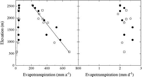
The observed linear altitudinal decline in the annual ET () can be completely explained by the altitudinal reduction of the vegetation period (CitationWieser, 1983; Wieser et al., 1984; CitationMenzel et al., 1998; CitationKörner, 2003). When the growing season water loss was divided by the number of snow-free days (see ), the altitudinal gradient disappeared and the daily mean of grassland ET during the growing season ranged from 1.9 to 2.6 mm d−1 and averaged 2.2 mm d−1 (; CitationWieser, 1983; Wieser et al., 1984). The growing season mean ET of the grasslands under study is similar to the value of 2.0 mm d−1 obtained for mixed forest stands in the Alps between 490 and 1950 m a.s.l. (Matyssek et al., personal communication).
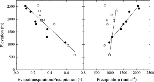
The leaf area index of grassland ecosystems declines from peak values of 6-8 in the valley floor (CitationKörner and Mayr, 1981; CitationWohlfahrt et al., 2001) to less than 2 in the alpine grassland belt (CitationCernusca and Seeber, 1981). As a consequence of the declining leaf area index, wind velocity (CitationWohlfahrt and Cernusca, 2002) and aerodynamic conductance were found to be significantly higher in the alpine grassland belt as compared to pastures and meadows at lower elevations (CitationCernusca and Seeber, 1981). Due to the altitudinal decline in leaf area, evaporation from the soil surface below the vegetation cover increases from 10% of total ET in the valley floor (CitationRutter, 1975) up to approximately 25% in the alpine sedge belt (CitationKörner, 1977; CitationKörner et al., 1980). Moreover, due to heat accumulation in the canopy (CitationKörner, 2003), low stature alpine grasslands often heat up to a larger extent causing the driving forces for ET to increase (CitationCernusca and Seeber, 1981). Consequently, high elevation plants display higher leaf conductances (CitationKörner and Mayr, 1981) and higher stomatal densities (CitationKörner et al., 1989) than comparable plants at lower elevations. Periodic soil water shortage at low elevation sites with soil water potentials close to the wilting point cause stomatal restrictions much more often as compared to plants growing above the timberline (CitationKörner and Mayr, 1981), where soil water potentials seldom drop below critical values (CitationNeuwinger-Raschendorfer, 1961; CitationNeuwinger, 1970, Citation1980; CitationGunsch ,1972; CitationWieser et al., 1989), even during the Central Europe–wide extremely dry summer of 2003 (CitationRebetez et al., 2006; CitationWieser and Tausz, 2007). This may be attributed to the higher amount of precipitation () and to the fact that rain is observed every third or fourth day on average above the timberline (CitationFrei and Schär, 1998).
FIGURE 6 Annual evapotranspiration normalized with precipitation (left) and precipitation (right) with respect to elevation of grassland ecosystems located on the southern outer rim of the Austrian Alps (•), the inner Alpine region(○), and the Northern limestone Alps (□) between 580 and 2550 m a.s.l. Solid lines show best fits to data using linear models (left: all data pooled; r 2 = 0.83, p = 0.00; right: southern outer rim of the Austrian Alps: r 2 = 0.97, p = 0.00, Northern limestone Alps: r 2 = 0.98, p = 0.04).
The Annual Water Balance With Respect to Altitude
Annual evapotranspiration normalized with precipitation (E/P ratio) decreased with increasing altitude ( left; all data pooled r 2 = 0.83, p = 0.00); conversely runoff normalized with precipitation (R/P value) increased with increasing altitude and equaled E/P at approximately 1300 m a.s.l. Theses trends were much more pronounced on the southern outer rim as compared to the inner Alpine region and the Northern limestone Alps. This results from the fact that there is no unique relation between altitude and precipitation in the Alps (CitationSchröter, 1926; CitationSteinhauser et al., 1960; CitationEllenberg, 1996; CitationFranz, 1979; CitationBaumgartner, 1980; CitationFliri, 1975; CitationVeit, 2002). On average, annual precipitation increased by approximately 75 mm per 100 m of altitude and by less than 15 mm per 100 m of altitude in the southern outer rims and the Northern limestone Alps, respectively (, right). In the inner Alpine region, by contrast, precipitation did not change significantly with altitude and averaged 980 mm irrespective of height above sea level (, right).
Conclusions
Our compilation of studies on the water balance of grassland ecosystems in the Austrian Alps leads to the following conclusions: (1) even during dry years grassland ecosystems in the Austrian Alps seem not to suffer from water stress; (2) the observed linear altitudinal decline in annual ET can be explained by the altitudinal shortening of the snow-free period; and (3) with increasing altitude runoff, at the expense of ET, dominates the water balance.
The major part of studies contained in this compilation was conducted in the late 1970s. Given recent evidence of climate change impacts on mountain ecosystems, in particular the accelerated warming rates at high altitudes (CitationKromp-Kolb and Formayer, 2005), it may thus be timely to repeat those measurements in order to detect and quantify possible effects of climate change on the water balance of Austrian Alpine grassland ecosystems.
Acknowledgments
Part of this study was financially supported by the EU FP 5 project CARBOMONT (EVK2-CT2001-00125), the Austrian National Science Fund (P17560), and the Tyrolean Science Fund (Uni-404/33). The Hofer family (Neustift, Austria) is thanked for granting us access to the Neustift study site.
References Cited
- Baumgartner, A. 1980. Mountain climates from a perspective of forest growth. In Benecke, U. and M. R. Davis , editors. Mountain environments and subalpine forest growth Wellington. Proceedings IUFRO Workshop November 1979 Christchurch, New Zealand. New Zealand Forest Service,. 27–39. Technical Paper No. 70.
- Campbell, G. S. and J. M. Norman . 1998. An introduction to environmental biophysics New York Springer Verlag. 2nd edition.
- Cernusca, A. and M. C. Seeber . 1981. Canopy structure, microclimate and energy budget in different alpine plant communities. In Grace, J. , E. D. Ford , and P. G. Jarvis , editors. Plants and their atmospheric environment The 21st Symposium of the British Ecological Society Edinburgh 1979. Oxford Blackwell. 75–81.
- Cernusca, A. , U. Tappeiner , and N. Bayfield . 1999. Land-use changes in European mountain ecosystems. ECOMONT—Concepts and results Berlin Blackwell Wissenschaftsverlag. 368 pp.
- Courtin, G. M. and L. C. Bliss . 1971. A hydrisatic lysimeter to measure evapotranspiration under remote field conditions. Arctic and Alpine Research 3:81–89.
- Ellenberg, H. 1996. Vegetation Mitteleuropas mit den Alpen in ökologischer, dynamischer und historischer Sicht Stuttgart Verlag Eugen Ulmer.
- Fliri, F. 1975. Das Klima der Alpen im Raume von Tirol. Monographien zur Landeskunde Tirols I Innsbruck, München Universitätsverlag Wagner.
- Franz, H. 1979. Ökologie der Hochgebirge Stuttgart Ulmer.
- Frei, Ch and Ch Schär . 1998. A precipitation climatology of the Alps from high-resolution rain-gauge observations. International Journal of Climatology 18:873–900.
- Guggenberger, H. 1980. Untersuchungen zum Wasserhaushalt der alpinen Zwergstrauchheide Patschertkofel Ph.D. thesis. Austria Botany, Innsbruck University.
- Gunsch, J. 1972. Vergleichende ökologische Untersuchungen von Kleinstandorten im Bereich der subalpinen Zirben-Waldgrenze Ph.D. thesis. Austria Botany, Innsbruck University.
- Hall, D. O. and J. M. O. Scurlock . 1991. Climate change and productivity of natural grasslands. Annales of Botany 67 (suppl.):49–55.
- Hammerle, A. , A. Haslwanter , M. Schmitt , M. Bahn , U. Tappeiner , A. Cernusca , and G. Wohlfahrt . 2007. Eddy covariance measurements of carbon dioxide, latent and sensible energy fluxes above a meadow on a mountain slope. Boundary-Layer Meteorology 122:397–416.
- Henning, D. 1974. Zur Regenmessung an Hängen. Wetter und Leben 26:94–97.
- Kern, H. 1975. Mittlere jährliche Verdunstungshöhen 1931–1960. München: Schriftenreihe des Bayerischen Landesamtes für Wasserwirtschaft 2 pp.
- Koehl, A. 1971. Die Landesverdunstung im schweizerischen Rheingebiet. Jahresbericht der naturforschenden Gesellschaft Graubündens N.F. 94:193–198.
- Körner, Ch 1977. Evapotranspiration und Transpiration verschiedener Pflanzenbestände im alpinen Grasheidegürtel der Hohen Tauern. In Cernusca, A. , editor. Alpine Grasheide Hohe Tauern. Ergebnisse der Ökosystemstudie 1976 Veröffentlichungen des österreichischen MaB Hochgebigsprogramms Hohe Tauern Vol. 1. Innsbruck Universitätsverlag Wagner. 47–68.
- Körner, Ch 2003. Alpine plant life: functional plant ecology of high mountain ecosystems Berlin Springer. 349 pp. 2nd edition.
- Körner, Ch and R. Mayr . 1981. Stomatal behaviour in alpine plant communities between 600 and 2600 metres above sea level. In Grace, J. , E. D. Ford , and P. G. Jarvis , editors. Plants and their atmospheric environment The 21st Symposium of the British Ecological Society Edinburgh 1979. Oxford Blackwell. 205–218.
- Körner, Ch , H. Hoflacher , and G. Wieser . 1978. Untersuchungen zum Wasserhaushalt von Almflächen in Gasteiner-Tal. In Cernusca, A. , editor. Ökologische Analysen von Almflächen im Gasteiner Tal Veröffentlichungen des Österreichischen MaB-Hochgebirgsprogramms Hohe Tauern, Band 2. Innsbruck Universitätsverlag Wagner. 67–79.
- Körner, Ch , G. Wieser , and H. Guggenberger . 1980. Der Wasserhaushalt eines alpinen Rasend in den Zentralalpen. In Franz, H. , editor. Untersuchungen an alpinen Böden in den Hohen tauern 1974–1978. Stoffdynamik und Wasserghaushalt Veröffentlichungen des Österreichischen MaB-Hochgebirgsprogramms Hohe Tauern, Band 3. Innsbruck Universitätsverlag Wagner. 243–264.
- Körner, Ch , M. Neumayer , S. Pelaez Menendez-Riedl , and A. Smeets-Scheel . 1989. Functional morphology of mountain plants. Flora 182:353–383.
- Kromp-Kolb, H. and H. Formayer . 2005. Schwarzbuch Klimawandel Salzburg Verlag ecowin.
- Kronfuss, H. 1997. Das Klima einer Hochlagenaufforstung in der subalpinen Höhenstufe. Haggen im Sellraintal bei St. Sigmund, Tirol (Periode 1975–1994). FBVA Bericht Wien. 100 pp.
- Laboratoire des Ecosystèmes Alpines, 1995. Bibliographie de documentes pour la carte de la vegetation des Alpes (Volumes I à X) et documentes de la cartographie écologique (Volumes XI à XXXI) Universitè de Grenoble. 1–83.
- Larcher, W. 2001. Ökophysiologie der Pflanzen: Leben, Leistung und Stressbewältigung der Pflanzen in ihrer Umwelt Stuttgart Ulmer.
- Menzel, L. , H. Lang , and M. Rohrmann . 1998. Mean annual evapotranspiration 1973–1992 Bern Federal Office of Topography. Hydrological Atlas of Switzerland, Plate 4.1.
- Meyers, T. 2001. A comparison of summertime water and CO2 fluxes over rangeland for well watered and drought conditions. Agricultural and Forest Meteorology 106:205–214.
- Müller, W. 1965. Zur Schätzung der Gebietsverdunstung im Gebirge. Arciv für. Meeorologie, Geophysik und Bioklimatologie 13:193–206. Serie B,.
- Neuwinger, I. 1970. Böden der subalpinen und alpinen Stufe in den Tiroler Alpen. Mitteilungen der Ostalpin-Dinarischen Gesellschaft für Vegetationskunde 11:135–150.
- Neuwinger, I. 1980. Erwärmung, Wasserrückhalt und Erosionsbereitschaft subalpiner Böden. Mitteilungen der Forstlichen Bundesversuchsanstalt Wien 139:113–144.
- Neuwinger-Raschendorfer, I. 1961. Bodenfeuchtemessungen. Mitteilungen der Forstlichen Bundesversuchsanstalt Mariabrunn 59:257–264.
- Rebetez, M. , H. Mayer , O. Dupont , D. Schindler , K. Gartner , J. P. Kropf , and A. Menzel . 2006. Heat and drought 2003 in Europe: a climate synthesis. Annales of Forest Science 63:569–577.
- Rosset, M. , M. Montani , M. Tanner , and J. Fuhrer . 2001. Effects of abandonment on the energy balance and evapotranspiration of wet subalpine grassland. Agriculture, Ecosystems and Environment 86:277–286.
- Rutter, A. J. 1975. The hydrological cycle in vegetation. In Monteith, J. L. , editor. Vegetation and Atmosphere London, New York, San Francisco Academic Press. 179–185.
- Schiechtl, H. M. and R. Stern . 1974. Vegetationskartierung—Durchführung und Anwendung in Forschung und Praxis. Festschrift 100 Jahre Forstliche Bundesversuchsanstalt Wien 273–308.
- Schröter, C. 1926. Das Pflanzenleben der Alpen. Eine Schilderung der Hochgebirgsflora Zürich Verlag Albert Raustein.
- Scott, D. , N. G. Bayfield , A. Cernusca , and D. A. Elston . 2002. Use of a weighing lysimeter system to assess the effects of trampling on evapotranspiration of montane plant communities. Canadian Journal of Botany 80:675–683.
- Staudinger, M. and H. Rott . 1981. Evapotranspiration at two mountain sites during the vegetation period. Nordic Hydrology 12:207–216.
- Steinhauser, F. , O. Eckel , and F. Lauscher . 1960. Klimatographie von Österreich Wien Springer. 137–380.
- Steinhäußer, H. 1952. Über die Gebietsverdunstung in den österreichischen Südalpen. Berichte des deutschen Wetterdienstes 35:174–178.
- Steinhäußer, H. 1970. Gebietsverdunstung und Wasservorrat in verschiedenen Seehöhen Österreichs. Österreichische Wasserwirtschaft 22:163–170.
- Stigter, C. J. 1974. Precipitation measurements above a maize crop. Archiv für Meteorologie, Geopysik und Bioklimatilogie 24:95–108. Ser. B,.
- Tasser, E. , U. Tappeiner , and A. Cernusca . 2001. Südtirols Almen im Wandel. Ökologische Folgen von Landnutzungsänderungen Europäische Akademie Bozen. 269 pp.
- Veit, H. 2002. Die Alpen—Geoökologie und Landschaftsentwicklung Stuttgart Ulmer.
- Wever, L. A. , L. B. Flanagan , and P. J. Carlson . 2002. Seasonal and interannual variation in evapotranspiration, energy balance and surface conductance in a northern temperate grassland. Agricultural and Forest Meteorology 112:31–49.
- Wieser, G. 1983. Bodenwassserhaushalt alpiner Ökosysteme Ph.D. thesis. Austria Botany, Innsbruck University.
- Wieser, G. and M. Tausz . 2007. Trees at their upper limit. Tree life limitation at the alpine timberline Dordrecht, The Netherlands Springer. 232 pp. Plant Ecophysiology Vol. 5.
- Wieser, G. , Ch Körner , and A. Cernusca . 1984. Der Wasserhaushalt von Graslandökosystemen in den österreichichen Alpen. In Hegg, O. , editor. Verhandlungen Gesellschaft für Ökologie 89–99. Bd. XII. Bern 1982.
- Wieser, G. , I. Neuwinger , and A. Cernusca . 1989. Der Bodenwasserhaushalt alpiner Graslandgesellschaften zwischen1600 und 2600 m Höhe. In Cernusca, A. , editor. Struktur und Funktion von Graslandökosystemen im Nationalpark Hohe Tauern Veröffentlichungen des Österreichischen MaB-Hochgebirgsprogramms Hohe Tauern, Band 13. Innsbruck Universitätsverlag Wagner. 95–118.
- Wohlfahrt, G. 2004. Modelling fluxes and scalar concentrations of CO2, H2O and sensible heat within and above a mountain meadow canopy: a comparison of three Lagrangian models and three parameterisation options for the Lagrangian time scale. Boundary-Layer Meteorology 113:43–80.
- Wohlfahrt, G. and A. Cernusca . 2002. Momentum transfer by a mountain meadow canopy: a simulation analysis based on Massman's (1997) model. Boundary-Layer Meteorology 103:391–407.
- Wohlfahrt, G. , S. Sapinsky , U. Tappeiner , and A. Cernusca . 2001. Estimation of plant area index of grasslands from measurements of canopy radiation profiles. Agricultural and Forest Meteorology 109:1–12.