Abstract
A selective review of lichenometry as used to date Holocene moraines in five diverse regions of Alaska and in southeastern Kamchatka suggests that growth curves for this North Pacific area may be improved by attention to several factors. These included lichen identification, control point number and distribution, radiocarbon calibration, alternative curve models, and compatibility of lichen growth rate with climate. Support for control points presented for Kamchatka and published for Alaska areas will benefit from supplementary control at and beyond the break from the great growth curve segments of the last centuries. With regard to alternative—linear, logarithmic, and composite curve—models drawn for the published lichenometric data, the composite (logarithmic and linear composite models) appear the best fit for the Brooks Range and Wrangell–St. Elias areas of slow growth and continental interior climates. Calibration of 14C ages make minor changes in well-controlled curves, but differences may be marked where a single age supports the long-term portion of growth curves.
Lichen subgenus Rhizocarpon section Geographicum and section Alpicola should, and usually can be, differentiated in North Pacific areas. Nevertheless, growth curves that may represent both yellow-green Rhizocarpons (e.g., central Brooks Range and southeastern Kamchatka) appear to allow derivation of reasonable surface dating where the taxa distribution is similar to that of the curves. Chronologies of glaciation based on lichenometry of moraines over the last millennium in these two areas across the Bering Sea are strikingly similar to each other and to more precisely dated tree-ring-based glacial chronologies in southern Alaska.
Introduction
Lichenometry has been of substantial use in reconstruction of Holocene glacier chronologies across parts of the North Pacific margin (). In Alaska, such applications began in the late 1960s (CitationReger, 1968; CitationDenton and Karlén, 1973; CitationCalkin and Ellis, 1980). Comparable moraine studies are unknown at similar latitudes of Siberian Russia; however, much work has been initiated farther south in southeastern Kamchatka (CitationSolomina et al., 1995; CitationSavoskul and Zech, 1997). In order for lichenometry to maintain its potential and reliability across these and adjoining sparsely forested and glaciated regions, we here critically review, update, and question aspects of our own work and that of others in these areas. For example, we provide additional, previously unpublished data for Kamchatka curve control points and calibrate new lichen curves for both Kamchatka and Alaska. However, we also consider questions related to models of growth curve construction and the time frames of their reliable application, and we correlate lichen-dated late Holocene glacier chronologies across the North Pacific. Our analysis is considered in terms of 5 published growth curves for lichen subgenus Rhizocarpon that span mainland Alaska and a single growth curve for this taxa from southeastern Kamchatka. Other lichenometric data may be found in the original published papers on each area.
Physical Settings
The Alaskan published and accepted lichen studies considered in this paper occur in 5 distinct areas. From north to south these are the central Brooks Range (CitationCalkin and Ellis, 1980, Citation1984), the Kigluaik Mountains in the Seward Peninsula (CitationCalkin et al., 1998), the east-central Alaska Range (CitationBegét, 1994), the southeastern Wrangell and northeastern St. Elias Mountains (CitationDenton and Karlén, 1973; CitationKarlén, 1973), and the southern Kenai Mountains of Alaska's Kenai Peninsula (CitationWiles, 1992; CitationWiles and Calkin, 1994). These sites are located between 69° and 59° N. The Kamchatka lichen area (CitationSolomina et al., 1995, Citation1999) lies in the southeastern part of the peninsula between about 56° and 53° N ().
ALASKA
The topography and climate of Alaska () is as diverse as its mosaic of bedrock terranes patched together by plate tectonics over the last 200 million yr. Present glaciers cover some 74,700 km2, or about 5% of the state. Most of the ice occurs as large icefields with temperate glacier tongues. These are centered between 4000 and 6000 m a.s.l. in mountain ranges extending in an arcuate belt of 2000 km peripheral to precipitation sources in the Gulf of Alaska ().
The maritime Gulf air-sea climate is dominated by the Alaska gyre driven in spring and winter by the Aleutian Low (CitationWilson and Overland, 1987). Moist air masses penetrate north and eastward over glaciers near sea level in the Gulf and over the southern flanks of the very high Alaska Range and the Wrangell–St. Elias Mountains. The interior, northern mountain flanks are markedly drier and continental. In addition, glaciers are more dispersed and smaller northward, farther from precipitation sources, and occur on 1000- to 3000-m mountain surfaces. In central and arctic Alaska, snowlines and glaciation thresholds rise eastward, reaching 2000 m along the border with Canada.
Vegetation in southern Alaska is dominated by dense and tall Picea and Tsuga coastal forests (CitationViereck and Little, 1972). Slower-growing boreal, Picea glauca–Betula papyrifera forests (taiga) are scattered through interior Alaska to the south slopes of the Brooks Range. Treeless tundra occurs on the north slope of the Brooks Range and also along most of the western margin of Alaska, including the Aleutian Islands.
KAMCHATKA
This mountainous peninsula of the North Pacific () is characterized by 29 active and at least 300 extinct volcanoes. The largest glaciated region in northeastern Asia, it includes 446 glaciers covering about 906 km2. The main glacier centers occur in the highest Sredinny and Eastern ridges. The lichenometric studies were carried out in southeastern Kamchatka, to the north of the Avacha River and east of the Kamchatka River. The most prominent orographic features affecting Holocene glaciers are the Eastern Ridge and separate volcanic plateaus with the individual stratovolcano cones. The Kliuchevskaya Group, with the highest and most active volcanoes such as Kliuchevskoy and Plosky Tolbachik, encompasses a volcanic plateau 90 km long at 1000 to 1100 m altitude. The Avachinskaya group of volcanoes is closer to the ocean and consists of the active Avachinsky (2751 m) and Koryaksky (3456 m) as well as the extinct and partly eroded Kozel'sky, Aak, and Arik volcanoes (CitationVinogradov, 1968).
The climate of Kamchatka () is characterized by strong cyclonic activity. The maritime eastern coast has mild and snowy winters, and summers are cool and rainy. Equilibrium-line altitudes (ELAs) vary from 700 to 1000 m a.s.l. for glaciers of the Kronotsky Peninsula to 2700 m a.s.l. for those of the Kliuchevsloy volcanic group (). Betula forests are typical for this region, whereas coniferous and mixed forests dominate in the central part of the peninsula. Here, climate is more continental with colder but less snowy winters and rather warm summers.
Field Methods
Lichenometry and dating of glacial moraines in Alaska and Kamchatka were undertaken with very similar procedures. For Alaska, see CitationDenton and Karlén (1973), CitationCalkin and Ellis (1980), CitationWiles and Calkin (1994), and CitationCalkin et al. (1998). Details for Kamchatka lichenometry methods are considered by CitationSolomina et al. (1995) and CitationSavoskul (1999).
Field workers measured the long axis of the largest Rhizocarpon subgenus, and we assume the lichens with distinct and circular or subcircular borders. Most searched the entire surface under investigation. CitationSavoskul (1999) in Kamchatka subdivided the surfaces larger than ∼1000 m2 into zones and searched squares ∼10 m on a side. The entire surface of smaller landforms was searched. For the moraines smaller than 400 m2, lichens were reported from squares of 4 m on a side.
The size of the largest lichen measured was normally used as the age predictor for the site. Lichens were generally rejected as anomalous if their diameters exceeded the size of the next smaller one by more than 20% (CitationCalkin and Ellis, 1980). In the Kigluaik Mountains of Alaska, CitationCalkin et al. (1998) averaged the 5 largest lichens, but in all cases, the single largest lichen was very close to their average.
Perhaps the most important and unclear factor of lichenometric approaches among studies cited in this paper concerns identification of the section and species of the yellow-green subgenus Rhizocarpon measured. The specific lichen taxa that were described may reflect the occurrence of different lichens within the studied areas. Most workers seem to have used the aggregated “species” as noted by writing “Rhizocarpon geographicum, R. g. sensu lato” (s.l.), or giving other indications. CitationCalkin and Ellis (1980), CitationBegét (1994), and CitationCalkin et al. (1998) stated this clearly; CitationCalkin et al. (1998) attempted to use only R. sect. Alpicola. CitationDenton and Karlén (1973) implied use of the species R. geographicum but admitted possible inclusion of R. superficiale thalli. CitationWiles and Calkin (1994) designated their curve in the Kenai Mountains to be for R. sect. Alpicola. In Kamchatka, CitationSavoskul (1999) distinguished the species R. geographicum L(DC) and R. sect. Alpicola, presenting two separate and significantly different growth curves. CitationSolomina et al. (1995) used the aggregate, R. geographicum (s.l.), for moraines dated under 300 yr old.
Control Points
We summarize below both published and new lichenometric data of our own for settings and control points used by individual authors. The data of CitationSolomina (1999) for Kamchatka is presented in more detail. Specific problems with these curves are addressed below under “Growth Curves.”
ALASKA
Brooks Range
Among the 5 published lichen curves considered for Alaska, the one developed in the central Brooks Range along the Dalton Highway and adjacent Trans-Alaska Pipeline may be the most critical for moraine dating. The 14 control points, which are listed in and described with the original and updated curves of by CitationCalkin and Ellis (1980, Citation1984, respectively), occur mostly along a 120-km transect between 450 and 1700 m altitude. This transect extends northward from below and south of treeline on the south flank of the range and across the Continental Divide at Atigun Pass. The glaciers and moraines of the Brooks Range occur to the north and above treeline, where wood or other materials for effective numerical dating of the late Holocene moraines are rare or absent. The original and updated curves incorporated linear extrapolations beyond local point control by analogy with measurements of R. geographicum obtained in other areas of the world, where climate was similar. In this form, they were applied to date glacier fluctuations both 250 km east into the eastern Brooks Range and 250 km west of the control-point transect of the central Brooks Range. CitationEvison et al. (1996) argued that the climatic differences between the Dalton Highway sites and the moraine sites, which are more widespread along the divide, were negligible. Furthermore, the altitudinal distribution, and corresponding climatic environments, of the control sites is wider than those of the dated glacier moraines.
Seward Peninsula
Seven control points for a lichen curve were assembled to date moraines of 3 very small cirque glaciers in the Kigluaik Mountains of the Seward Peninsula, Alaska (CitationCalkin et al., 1998: , ). These points, which yield calendar dates, occur at altitudes from near sea level at Nome to 600 m for the oldest point of about 210 yr. The original curve of CitationCalkin et al. (1998) was extended beyond this control point only on the basis of bracketing curves for Swedish Lapland and the Wrangell–St. Elias Mountains area of Alaska (CitationKarlén, 1973).
Central Alaska Range
The lichen curve of CitationBegét (1994) for the central Alaska Range, and considered in this paper (), supersedes one developed by CitationReger (1968; CitationReger and Péwé, 1969) applied to date moraines of 4 glaciers in this same east-central Alaska Range. CitationPéwé and Reger (1983), recognizing major flaws in the control points, subsequently abandoned this curve in favor of that of CitationDenton and Karlén (1973), assembled 300 km to the southeast in the Wrangell–St. Elias Mountains area (below).
CitationBegét's (1994) curve utilizes 2 historical control points of CitationBijkerk (1980; CitationTen Brink, 1983, Citation1984) obtained from up to 250 km to the west in the Alaska Range. Five points come from CitationPéwé and Reger (1983) and 1 point of CitationReger and Péwé (1991), developed at the Gulkana Glacier and 2 other nearby valley glaciers in the east-central area at near 1000 m altitude. CitationBegét's (1994) point 7 dated at ∼800 yr BP appears to be anomalous and is not used here. In addition, CitationBegét (1994) used a well-supported tephrochronological age of 3650 ± 125 yr BP for a 170-mm Rhizocarpon geographicum to complete the curve.
CitationBijerk (1980, Citation1984) adapted the curve of Denton and Karlén, considered below, along with 2 local control points to date moraines of surging glaciers in the Denali National Park area of the north-central Alaska Range. No further consideration is given to this work.
Wrangell–St. Elias Mountains
CitationDenton and Karlén (1973, Citation1977) and CitationKarlén (1973) discussed 13 control points (; ) for their lichen curve developed for the eastward (inland) draining White River valley and Skolai Pass area of the Wrangell–St. Elias Mountains contact near the international border with Canada. The control points are dated by historical criteria, tree rings, tephrochronology, and radiocarbon; most are located on the moraines themselves between 1100 and 1600 m. Point 12 of CitationDenton and Karlén (1973, Citation1977) relies in part on a near-maximum age of ∼1230 yr BP determined for the age of the eastern lobe of the White River Ash. This age is confirmed by the 14C dating of other samples of wood and is now specified as ∼1147 cal yr BP by CitationClague et al. (1995); the age is close to that used by Denton and Karlén for their curve (control point 12, ); therefore, no correction is applied.
Kenai Peninsula
A growth curve for R. section Alpicola is controlled by 18 tree-ring ages, distributed mostly on the alpine glacier moraines along 120 km of the northwest flank of the southern Kenai Mountains, Kenai Peninsula (, ). An additional 3 historical dates come from the southern part of the peninsula (CitationWiles, 1992; CitationWiles and Calkin, 1994). This curve has been applied sparingly over the same area where some glaciers and moraines are above treeline or devoid of datable vegetation.
Lichen growth is more rapid in this southern Alaska maritime area than at the other lichen sites in Alaska. However, the vigorous growth of other vegetation is inhibiting, so substrates and lichen are less useful with time. Therefore, the resulting curve constructed here is useful for only a few hundred years.
Northern Kenai Peninsula
An 80-to-100-yr linear curve for “Rhizocarpon sp.” (composite species) has been developed by CitationCrossen (1997) for dating deposits of the Blackstone-Spencer Ice Complex tongues in the moist, northern part of the Kenai Mountains and Peninsula. Based on 4 historical control points and 1 dendrochronological age, it displays a growth rate compatible with that of the CitationWiles and Calkin (1994) curve but slightly higher. Details are not considered further in this paper.
KAMCHATKA
Two major growth curves for subgenus Rhizocarpon section Rhizocarpon have been proposed for the same general area of southeastern Kamchatka. The first was developed by CitationSolomina et al. (1995); its original control and subsequent modification by new control points (CitationSolomina et al., 1999) is the major topic of the notes in this section. A second curve was proposed by CitationSavoskul and Zech (1997) with minor modification by CitationSavoskul (1999), who also developed a curve for subgenus R. section Alpicola. These are considered under the last subheading of this section.
The first curve (CitationSolomina et al., 1995) was based on a linear approximation from 7 control points on substrates younger than 320 ± 40 yr BP. Control points for a subsequent composite (R. geographicum s.l.) lichen growth curve were obtained in 1992, 1993, and 1997 in different parts of southeastern Kamchatka (CitationSolomina, 1999) (; , VI). These include the Avacha area, near the Kliuchevskoy and Tolbachik volcanoes, and Kronotsky Peninsula. Although we have defined some annual climatic differences between coastal and interior Kamchatka sites, the mean monthly summer temperature, which is critical for lichen growth, is very similar in both areas (e.g., 11° C in coastal Kamchatka and 13° C in the interior []). The growth rates of lichens across this 400-km-long area of southeastern Kamchatka are found to be compatible. This conclusion is supported by the lichen data, including, for example, the similarity of the lichen diameters recorded on moraines deposited shortly before AD 1854–1855 at Kozel'sky, Koryto, and Ermann glaciers in coastal and more interior areas of southeastern Kamchatka, respectively (CitationSolomina, 1999).
The control points for Kamchatka (, VI 1–16) include points on lava flows, moraine, and lahar deposits, ranging from 300 to 1000 m in elevation and dated by historical, tree-ring, and tephrochronological methods. The young lava flows (1–4) as well as the AD 1970s moraine of Kozel'sky Glacier (5) are reliably dated by observations. Two points on older moraines of Kozel'sky Glacier, AD 1855–1907 (6) and 320 ± 40 yr BP (7), were obtained by Avacha tephra markers. However, an older moraine (7) appears to have been washed, and few lichens occur on it; those that do range from 76 to 69 mm for the 5 maximum thalli. We use this site with caution as a control point for our curve. The moraine of Emann Glacier (8), with lichens as large as 35 mm, is directly covered by the Shiveluch' tephra layer deposited in AD 1854. All these sites (1–8) are described by CitationSolomina et al. (1995).
Control points 9–16 are discussed under specific geographic headings in the following sections because they deserve more comment, especially the moraines of Koryto Glacier. These have been described only briefly before (CitationSolomina et al., 1999) and are of great importance. They represent the whole sequence of plant succession from the very young surfaces left by the retreating glacier in recent years to the Little Ice Age maximum moraines several hundred years old.
Moraines of Koryto Glacier, Kronotsky Peninsula
Tree-ring analyses and tephrochronology was used to constrain the age of moraines of Koryto Glacier (; , VI 9–11). CitationSolomina et al. (1999) dated 6 samples of alder (Alnus hirsuta Turcz.) growing on the moraines in 1998. Because no alders older than 90 yr were found, this technique could be used to date only moraines up to a century old. Initial forest colonization of the moraines in this region started 10 to 15 yr after glacier retreat. For example, following advances of the late 1950s, some small bushes were already growing on the newly exposed moraines.
Moraines of point 9 at Koryto Glacier were deposited in the late 1950s, according to CitationVinogradov (1968). The earliest alder to colonize were 9 and 13 yr old, and Rhizocarpon reached up to 9 mm in 1968.
The end moraine of point 10 (), which consists of 3 ridges with lichens as large as 19, 20, and 23 mm, was deposited by 1910 to 1920, according to the ring count on the 2 thickest alders growing on its surface. Although thickness may not correlate with age, tephrochronology supports a maximum 150 yr for the moraine: no tephra overlies the moraines of points 9 and 10; therefore, they are considered to have been deposited after AD 1854 (CitationSawaguchi et al., 1999).
An older moraine of point 11 with noticeably larger lichen (37 mm) must have been deposited shortly before AD 1854, as it is overlain directly by the ash deposited on this date by Shiveluch Volcano. On the next older moraine ridge, with lichens as large as 60 mm, a 4-cm-thick soil underlies the same AD 1854 ash of Shiveluch Volcano, indicating that the 60-mm lichen surface is several decades or more older than that of point 11 (CitationSawaguchi et al., 1999).
The Lahar of Elyzovskaya Dry River, Avacha Area
A huge lahar (, VI 12), which followed the eruption of Avacha Volcano in AD 1926 in the Elizovskaya Dry River valley (CitationMelekestsev et al., 1995), left a bouldery surface at 450 m that is several hundred meters long and partly covered by birch forest. Maximum diameters of R. geographicum on exposed boulders of this point 12 are 22 mm.
The Lava Flow of Avacha Volcano
One of the largest eruptions of the Avacha Volcano in the last 250 yr occurred in AD 1827. A photograph of a lava flow (, point 13) with very distinctive lava fingers, slag cones, and hills, as well as fumaroles believed to be a product of this event, was taken shortly after eruption (CitationZavaritsky, 1977, p. 21). Radiocarbon ages of 220 ± 40, 70 ± 40, and 130 ± 40 yr BP obtained from charcoal in this flow (CitationMelekestsev et al., 1995) are compatible with the 1827 year of formation. Lichens reach a maximum of 43 mm on this flow.
The Lava Flow of Taunshits Volcano
A. and M. Belousov (pers. comm., 1998) reported the maximum sizes of Rhizocarpon lichens of unidentified species on a lava flow of Taunshits Volcano to be 140 mm (, VI 14). According to tephrochronological dating, the flow is believed to be about 2500 yr old (CitationMelekestsev et al., 1990). CitationSavoskul (1999) used this control point for the R. section Alpicola growth curve; CitationSolomina et al. (1999) used it for a growth curve of R. geographicum s.l. We use this control point cautiously because it is the only one available to constrain the older portion of the lichen curve. The use of this point in the growth curve is, in part, justified because it is consistent with lichen growth in the similar climate of central Alaska (CitationWatson, 1974).
Tephra Cone and Lava Flow of Koryaksky Volcano, Avacha Area
A tephra cone and lava flow at about 1000 m altitude on the southern slope of Koryaksky Volcano are dated by tephrochronology to about 3500 to 3900 BP and greater than 3900 BP, respectively. Rhizocarpon lichens (mainly section Alpicola) on their surfaces reach 230 mm and 240 mm, respectively. Because of the similarity in these lichen sizes and broad tephrochronological age range of the older deposits, we believe that they may be beyond the growth limit of lichens in this area. Points 15 and 16, presented in , could be incorporated in the composite lichen curve if additional support is found to justify inclusion in the future.
Summary of Kamchatka Control Points
Several control points outlined here have some weakness concerning age, but taken together, they are internally consistent. They are also sufficient in number to produce a preliminary growth curve in southeastern Kamchatka.
Control Points of CitationSavoskul and Zech (1997) and CitationSavoskul (1999)
The lichen curve for species Rhizocarpon geographicum by CitationSavoskul and Zech (1997) used 5 of the 20th-century control points employed by CitationSolomina et al. (1995) (, VI 1, 4, 5). However, 2 older points of approximately 150 and 300 yr were rejected, and 3 new points dated by tephrochronology at between 1200 and 6000 yr old were introduced. Based on this curve, the growth rate of southeastern Kamchatka's R. geographicum lichens appears to be an order of magnitude slower than that shown by the curve developed by CitationSolomina et al. (1995) and CitationSolomina et al. (1999). We believe there is a problem with the newer curve (CitationSavoskul and Zech, 1997). For example, we show here that the sequence of moraines at Koryto Glacier (; ) dated historically, by tree rings and by tephrochronology, demonstrates the regular increase of lichen size from 9 to 37 mm for the substrates designated as originating shortly before AD 1845 to AD 1950–1960. This increase yields a growth rate of ∼24 mm per century for the CitationSolomina et al. (1999) curve. CitationSavoskul and Zech (1997; CitationSavoskul, 1999) show a dramatic decrease from 0.25 mm yr−1 to 0.03 mm yr−1 after the first 50 yr of growth; this rate appears unreasonably slow to us. In addition to problems with the R. geographicum curve, we note that no control points younger than 1200 to 1400 yr are reported by CitationSavoskul (1999) for the R. section Alpicola curve (see also the “Lichen Growth Rates and Climate” section below).
Growth Curves
CALIBRATION OF RADIOCARBON AGES
The choice between programs of calibration for the 14C ages may result in significant differences among the choice of dates one may use in curve construction (). Such choices may be particularly critical for the old part of the growth curves that are frequently constrained by one or a few scattered ages that produce a systematic bias to derived lichenometric ages.
For demonstration of calibration effects, we display in (see also ) 14C data points used for the Brooks Range growth curve of CitationCalkin and Ellis (1980, Citation1984) together with corresponding values calibrated with Calib rev. 4.2 program, methods A and B (CitationStuiver and Reimer, 1993). With the method A, radiocarbon ages are calibrated by a simple intercept with a linear interpolation of the data points of the selected calibration dataset; method B takes into account the probability distribution of the data. The 2-sigma interval is generally too large for lichenometric purposes, as some 14C control point ages yield options up to a 600-yr range. In this paper, we used Calib method B, with 1-sigma confidence. In so doing, we took the midpoint of the age range associated with the calibration solution as having the highest probability. With the exception of 2 BP ages in the 200-yr range, all chosen age ranges had probabilities greater than 3 times that of the nearest alternative.
For the case of the Brooks Range, there is no major systematic change of the growth curve when we use uncalibrated versus calibrated 14C control dates; calibration results in a 100-yr offset for surfaces about 1500 yr old. Three control points become younger, 1 older after calibration.
The linear phase of the Brooks Range growth curve is relatively well constrained by 4 14C dates, and there are several control points dated historically and dendrochronologically. Therefore, there is little difference in the equations for lines derived from calibrated versus uncalibrated control-point dates (see captions for , ). The 3 oldest and most reliable 14C control points for both the calibrated and uncalibrated curves for the central Brooks Range fall within the 20% error interval for the new, calibrated curve. Similarly, the logarithmic curve of CitationMatthews (1974) also fits this error interval, although it shows the most prominent deviation from the control points.
GROWTH CURVE CONSTRUCTION
The shape of the lichen curve depends significantly on the choice of a model for lichen growth as well as on the control points and their distribution ( and ; ). Phases of prelinear growth, where thallus radius increases logarithmically, as well as linear and postlinear lichen growth have been described by CitationArmstrong (1974). However, in the practice of lichenometry, only 2 segments, a “great period” of fast growth and a phase of slower growth, are considered to shape the curve (CitationBeschel, 1961). Some authors (e.g., CitationWebber and Andrews, 1973; CitationDenton and Karlén, 1973; CitationCalkin and Ellis, 1980) accept the post–great growth period as a “linear phase”; others assume that the growth of lichen follows a logarithmic pattern during their whole life (CitationMatthews, 1974). The direct measurements of various sizes of Rhizocarpon lichens over 4 to 6 yr in the central Brooks Range (CitationHaworth and Calkin, 1986) suggest a similar nonlinear relationship of lichen diameters and age of the surface.
The Brooks Range curve of CitationCalkin and Ellis (1980) and that for the Wrangell–St. Elias Mountains of CitationDenton and Karlén (1973) (, I and IV, curves a) were originally drawn by hand and include a semilogarithmic great growth segment and a linear growth, old segment. The control points can also be described by CitationMatthews's (1974) logarithmic model of growth. The choice between these two models is not always clear, but we showed previously, through , that the composite curve used in the Brooks Range (CitationCalkin and Ellis, 1980) fitted much better than the logarithmic to the control points. For the Wrangell–St. Elias area the composite curve may be only slightly better than the logarithmic. In the 2 cases of slow-growing lichens, we recommend keeping the previous model of composite growth curve until further control is available.
The Seward Peninsula curve of CitationCalkin et al. (1998) (, IVa), relies partly on a linear regression for the function: lichen diameter vs. log10 time. However, the long-term portion of this composite growth curve was originally drawn parallel to the CitationDenton and Karlén (1973) curve from Swedish Lapland (CitationCalkin et al., 1998). Thus, it contains the linear growth phase. In (IIb) we also show that the logarithmic curve fits these control points, like those for relatively fast-growing lichens (, , Regions III, V, VI); however, there are no Seward Peninsula control points beyond 215 yr to support or reject this model.
The linear curve from the Kenai Mountains (, IIIa) is reported to be preliminary (CitationWiles and Calkin, 1994); nevertheless, it is well enough constrained to date deposits within the framework of available control points without further extrapolation. The log curve instead of the linear one yields slower rates in the older portion, but faster between about 50 and 250 yr. Because the Kenai Peninsula control points are obtained by ring counts of trees colonizing the moraines, it provides minimum age estimates. Therefore, the logarithmic curve based on the maximum dates may yield more realistic ages than the linear curve describing mean age values (, IIIb).
The central Alaska Range curve of CitationBegét (1994) is not constrained between about 200 and 4000 yr ago. It can approach a polynomial or logarithmic curve (, II) or consist of logarithmic and linear parts (curve b), although the time of transition from the fast to slow growth is unknown. Until additional control points are found, we suggest maintaining the original shape of the curve (, IIa).
A linear approximation was used initially to describe the growth rate of lichens in Kamchatka over the last 300 to 350 yr (, VIa) (CitationSolomina et al., 1995). Subsequently, CitationSolomina et al. (1999) attempted to use CitationMatthews's (1974) modification of the log curve to extrapolate this growth curve back in time (, VIb). This latter curve is problematic because of the unique control point supporting its old part.
For lichenometric dating, we propose the use of the composite growth curves given by the authors in the Brooks Range and Wrangell–St. Elias Mountains. The linear part of these curves is relatively well constrained. Logarithmic curves may be most appropriate for Kenai, central Alaska Range, and Kamchatka. Original extrapolations beyond the last control point make the appropriate curves less reliable, and we have not used them in our analysis.
LICHEN GROWTH RATES AND CLIMATE
The curves for Rhizocarpon lichens along the North Pacific margin show that rates of growth are consistent with regional climate (; ). In Alaska, the fastest-growing lichens, and probably the most subject to substrate weathering, are those along the Gulf of Alaska, including the Kenai Peninsula region, where warm marine currents and very high precipitation prevail.
The area of slowest growth and longest-lived lichens is that in the high-latitude Brooks Range (), far from the major precipitation sources of the Bering Sea. Brooks Range Rhizocarpon taxa reach at least 450 mm in maximum diameters over time periods probably extending back into the middle to early Holocene (CitationCalkin and Ellis, 1980; CitationHaworth, 1988).
Growth rates are only slightly faster under the continental climate of the inland-facing eastern flanks of the Wrangell–St. Elias Mountains (CitationDenton and Karlén, 1973) (), where the summers are short, warm, and dry. More moisture is available and growth rates faster than those of Wrangell–St. Elias sites in the maritime-continental regime encompassing the high-subarctic Kigluaik Mountains site of the Seward Peninsula. With low summer temperatures and moderate rainfall, Rhizocarpons reach 250 to 300 mm here. The Gulkana Glacier area of the east-central Alaska Range is also within or at the margin of the maritime-continental transitional climate zone, but it is also in the path of decaying maritime air masses that penetrate northward from the Gulf of Alaska (CitationWatson, 1974; CitationCalkin, 1988). Thus, in this setting lichens may be expected to grow faster than in the Seward Peninsula.
The Kamchatka lichen curve (, VI) is developed over a wide area encompassing both coastal maritime and inland transitional climatic regimes. In general, the climate is much milder than in the Brooks Range or Wrangell–St. Elias Mountains but colder than in the Kenai Mountains (). Kamchatka is periodically influenced by cold air masses from the Okhotsk Sea, whereas the climate of southern Alaska is, on the contrary, affected by the warm, counterclockwise Gulf of Alaska current. So we can expect the Kamchatka growth curve to be between curves of , IV (Wrangell–St. Elias) and V (Kenai), which is the case.
The only curves that do not fit the general climatic pattern of slower and longer growth toward the north and more interior regions are VII and VIII of from Kamchatka (CitationSavoskul, 1999). Several aspects of the two Kamchatka lichen curves of Savoskul (; ) suggest that both may be unrepresentative for R. geographicum and R. section Alpicola growth rates and should not be used for dating. Both curves lack sufficient control points for the initial rapid growth phase; the R. section Alpicola curve, which lacks any control for this initial phase (CitationSavoskul, 1999, ), appears to begin at about 800 yr ago (). Control points reach back in time about 6000 yr. Lichens are unlikely to live as long as 6000 yr in such areas with a climate of moderate to high moisture. The very slow lichen growths indicated by CitationSavoskul and Zech (1997) and CitationSavoskul (1999) relative to lichen curves for Alaska are not justified by the climatic pattern of the North Pacific or by any other special circumstances.
Discussion
TWO TYPES OF GROWTH CURVES
Two curve models seem to be appropriate to describe the growth of lichens in the North Pacific. In the maritime areas, where growth is relatively rapid, the logarithmic or even linear curves fit the control points best, and the long-term linear growth phase is absent (). These curves were used in Norway (CitationMatthews, 1974), New Zealand (CitationBirkeland, 1981), and Iceland (CitationGordon and Sharp, 1983). For regions of continental climate such as the Brooks Range or Wrangell–St. Elias Mountains, where the lichens are slower growing, the composite curve, including the linear part of constant growth, appears appropriate. This type of curve was applied first in the Colorado Front Range by CitationBenedict (1967) and discussed by CitationWebber and Andrews (1973) in their early, short review on lichenometry.
TIME FRAMES FOR USE OF LICHENOMETRY IN THE NORTH PACIFIC
The faster lichens grow, the shorter the time interval for possible dating. Potential lengths of dating range from 3 to 4 centuries or even less for the Kenai Mountains to almost the entire Holocene for the Brooks Range. In addition, the length of potential lichenometric dating is limited by an absence or insufficient number of numerical ages for old surfaces. In Kamchatka, as well as the Kenai and Seward Peninsulas, and even in the central Alaska Range, where the growth curve is constrained by a single tephrochronological age of 3650 ± 125 yr BP, the most reliable lichenometric ages available go back only about 300 yr. This limitation results in uncertainties in lichenometric dating during this interval. Extension of the curves beyond the oldest reliable control point is problematic. However, it is least insecure in the regions with slower growth rates, where two phases of growth are suggested and constrained by a number of reliable control points, as in the Brooks Range and the Wrangell–St. Elias Mountains areas. The choice of a single logarithmic curve model that also fits the control points () changes the results of dating of old moraines significantly.
TWO COMMON LICHEN TAXA
The problem of field identification, and particularly the differential growth rates of the two taxa most often used in lichenometry, R. geographicum s.l. and R. section Alpicola, have been discussed by several authors (e.g., CitationDenton and Karlén, 1973; CitationLock[e] et al., 1979; CitationInnes, 1982, Citation1983). R. geographicum s.l. will generally colonize a surface first and dominates on young surfaces; later-colonizing R. section Alpicola lichens, which grow slightly faster, begin to dominate and frequently are the taxa to reach the maximum diameters on the oldest surfaces (CitationInnes, 1982, Citation1983). Growth ratio of sizes of the largest diameters of the two taxa, R. geographicum and R. section Alpicola, was reported as 1:1.5 and 1:1.6, respectively, by CitationBeschel (1956) and CitationLøken and Andrews (1966). In Kamchatka it is about 3:2 for the great growth interval (up to a diameters of ∼60 mm) and 1:2 for the older surfaces. CitationInnes (1983) suggests that dating errors may occur where maximum lichen over ∼70–l00 mm of the aggregated Rhizocarpon (R. geographicum s.l., this paper) curve is used.
Here, where we focus on the consistency of the R. geographicum s. l. growth rate with climate, we can use the very young portions of the curves only (e.g., 500 yr old), which are most likely to be homogeneous in terms of species. The old portions of our growth curves () would be more secure with additional control. Nevertheless, we believe that in principle, the current control points, if obtained on surfaces with a sufficient number of lichens of both R. geographicum and R. section Alpicola taxa, can be used to date moraines with a similar set of lichens. That is, one can use an enveloping curve where the young part describes the growth rate of R. geographicum and the older part the growth rate of R. section Alpicola. However, this approach needs field-testing.
ACCURACY AND RELIABILITY OF LICHENOMETRIC DATES
Several attempts have been made to improve the accuracy, predictability, and reliability of lichenometric ages by using more sophisticated statistics rather than the single maximum diameter of lichen as a predictor of the surface age (CitationMatthews, 1974, Citation1975; CitationBull, 1996). However, in practice these techniques do not replace the traditional approach of moraine dating. The accuracy of lichenometric dates obtained by traditional methods is estimated to be of the order of ±15–20% (CitationMiller and Andrews, 1972; CitationCalkin and Ellis, 1980; CitationBickerton and Matthews, 1992). This error estimate, though a useful parameter, is not directly related to the real reliability of lichenometric ages that depend mostly on the number, accuracy, and distribution in time of control points that constrain the growth curve.
Lichenometric ages obtained with well-controlled growth curves may distinguish surfaces at least to century precision and rival some numerical or calendar dating methods. This is particularly true where, for example, radiocarbon analyses yield several control points for calibrated dates over the last millennium (e.g., CitationStuiver, 1982). Tree-ring dating, in turn, shares some problems with lichenometry—minimum ages for moraine surfaces, uncertain time of colonization, and the danger of mixing first-generation plants with advanced stages of succession (e.g., CitationReger and Péwé, 1991). However, lichenometry by itself is often superior in obtaining statistically significant data sets of ages for various deposit types in the same locality. For cold regions or high mountains beyond treeline, such as the Holocene moraines of the Brooks Range, or southeastern Kamchatka, it may be the only practical dating option.
Application of Lichenometry: Moraine Chronologies of the Brooks Range and Kamchatka
Holocene glacial chronologies that rely to varying degrees on historical, tree-ring, radiocarbon, tephrochronological, or lichenometric data are available for several regions of Alaska (e.g., CitationCalkin, 1988; CitationBegét, 1994; CitationBarclay et al., 2001). However, only the moraine chronology along the Brooks Range, south of the Arctic Ocean, utilized mainly lichenometry (CitationCalkin and Ellis, 1984; CitationHaworth, 1988; CitationCalkin, 1988).
Lichenometric data from 94 glaciers, most confined to cirques of the central Brooks Range, but also 8 larger valley glaciers in the eastern Brooks Range, allow definition of 3 and possibly 4 clusters of glacier advances or terminal stands over the last millennium (). The earliest advance, centered on about 1175 AD, follows several centuries of retracted glacier conditions and was in turn followed by an early-16th- and 17th-century interval of glacier advance. This interval is the most pervasive and is also controlled locally by radiocarbon ages of AD 1566 and 1637 from glacially overrun organics. In the eastern Brooks Range, end moraines dated at about 1875 to 1900 are more prominent than in the central Brooks Range (CitationEvison et al., 1996). Several hundred meters of recession has occurred from moraines of these advances.
Lichenometric ages of moraines in Kamchatka, although sparse, are similar to those of the Brooks Range (). In the Avacha region, the oldest and most prominent end moraines of the last millennium are those of the 19th century, although some older moraines may have been destroyed by lahars of this active volcano (CitationSolomina, 1997). The moraine sequence in Kronotsky Peninsula is more complete; however, the oldest moraines of the last millennium afford only minimum ages of the late 15th and 16th centuries. Possible older events may be obscured by subsequent advances. The most prominent advances of the late Holocene occurred in the mid-16th, early to mid-17th, and late 19th centuries. The Kamchatka glaciers have, on average, thinned about 100 m and retreated about 600 m from Little Ice Age maxima (CitationSolomina, 1999).
Both lichen-dated glacier chronologies of the Brooks Range and Kamchatka (, ) are surprisingly similar to the more precisely dated Holocene glacial chronologies on the Gulf of Alaska. These include ages derived from tree rings, radiocarbon, and lichen on the east and west flanks of the Kenai Mountains, Kenai Peninsula () and the chronologies calendar-dated by tree rings from glacially overrun forests on glacier forefields of Prince William Sound through Icy Bay (). CitationLuckman and Villalba (2001) have shown that there is a broad synchroneity of initiation and timing of these very precisely dated Little Ice Age glacial events with others along the western cordillera of the Americas.
Conclusions
In this review of lichenometric studies at the North Pacific borderland, we have expanded or updated some of our data but have also raised other critical issues:
1. Updated growth curves based on calibrated 14C ages are presented for Alaska and Kamchatka; the differences between calibrated and uncalibrated curves are slight in the case of the Brooks Range. Differences may be dramatic where a unique date supports the long-term portion of the growth curve.
2. Confident application of lichenometry in Alaska and Kamchatka will depend on obtaining new control points. These should not only extend the old-growth portions of the curve from its present limits of a few centuries to a millennium but should also help define the break from the early to the rapid-growth stages. In addition, where possible, both Rhizocarpon geographicum species and R. section Alpicola lichens should be recorded for control points for differentiation on separate curves.
3. The composite model of lichen growth, consisting of logarithmic and linear intervals, appears appropriate for regions of continental climate and slow growth rates. Fast-growing lichens may lack a long-term, linear portion of the curve.
4. Growth curves for Alaska and Kamchatka are compatible with climate, showing decreasing growth rates with continentality and increases with maritime conditions.
5. Chronologies of late Holocene glaciation based heavily on lichenometry of moraines in the Brooks Range of northern Alaska and southeastern Kamchatka are surprisingly similar considering their relative physical and climatic settings. They are, in turn, quite similar to more precise, tree-ring-dated chronologies along the Gulf of Alaska and western cordillera of the Americas. This is likely to be a real relationship and hence may support the reliability of our lichenometry.
We are convinced that where used judiciously, lichenometry is a useful dating tool in mountains and at high latitudes, and in the North Pacific in particular.
FIGURE 1. Location of glacial chronologies delineated in part or whole by lichenometry of moraines in Alaska (I–V) and Kamchatka (VI–VIII)
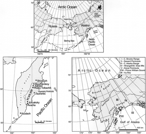
FIGURE 2. Koryto Glacier, Kronotsky Peninsula. Location of moraines dated by lichenometry. Numbers refer to data of , Kamchatka
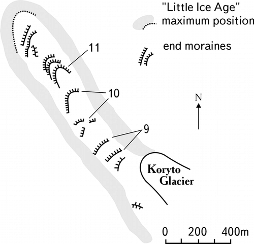
FIGURE 3. Comparison of uncalibrated radiocarbon dates (white circles and error bars), originally used for the growth curve construction by CitationCalkin and Ellis (1980, Citation1984) and the same dates, calibrated. Calib method A, white quadrats, and Calib method B, black circles, represent mean values of dates with 1-sigma confidence. A qualitative 20% error area (gray) is shown for the new, calibrated (method B) curve (solid line) presented in this paper. The linear part of the growth curve is based on 4 radiocarbon ages and the 2 oldest nonradiocarbon control points (6 and 7, ) (see text). The dotted line is based on the same control points, but the 14C dates are uncalibrated. The logarithmic curve is constructed using the method of CitationMatthews (1974) and is based on all control points listed in for the Brooks Range. Equations for all curves are given in . The linear curves fit best to the long-term growth phase. The three oldest, most reliable 14C-constrained control points, both calibrated and uncalibrated, fall within the 20% error interval
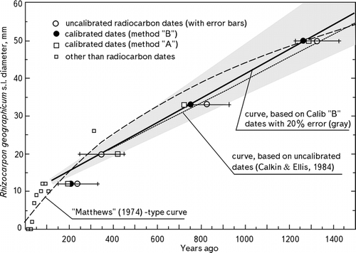
FIGURE 4. Different approaches to the construction of the Rhizocarpon growth curves. Radiocarbon dates are calibrated with Calib method B. Curves “a” are linear or composite curves. Composite curves consist of a logarithmic part for the great growth period and linear part describing the long-term growth. We followed the original published curves to estimate the length of the great growth period and the break from logarithmic to linear growth; however, the real duration of the great period in each case is still unknown. Curves “b” are full logarithmic curves. All equations are given in
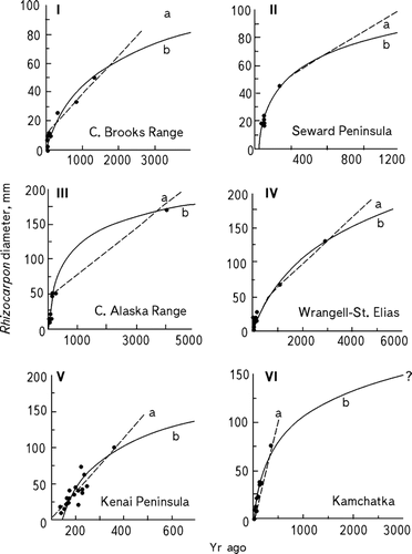
FIGURE 5. Control points and logarithmic curves (CitationMatthews, 1974) (except VII) used for uniformity to compare growth rates of lichens in each area of Alaska and Kamchatka. The numbers of the curves identified below correspond with those lichenometric regions given in Figure 1, , and through the text; lichen taxa used in curves and/or dated surfaces are as designated by authors. I. central Brooks Range—R. geographicum included species R. geographicum (L)DC and R. section Alpicola, R. eupetraeoides, R. inarense, possible R. superficiale [CitationCalkin and Ellis, 1980]). II. Seward Peninsula—R. geographicum (s.l.) may have included some species of I above, but mostly R. section Alpicola (CitationCalkin et al., 1998). III. Central Alaska Range—R. geographicum (undifferentiated species) (CitationBegét, 1994). IV. Wrangell—St. Elias Mountains—R. geographicum species and possible R. superficiale (CitationDenton and Karlén, 1973), V. Kenai Peninsula—R. section Alpicola (CitationWiles and Calkin, 1994). VI. Southeastern Kamchatka—R. geographicum s.l. (this paper). VII. Kamchatka—R. geographicum (L)DC. (CitationSavoskul, 1999); curve approximated by a linear curve. VIII. Kamchatka—R. section Alpicola (CitationSavoskul, 1999)
![FIGURE 5. Control points and logarithmic curves (CitationMatthews, 1974) (except VII) used for uniformity to compare growth rates of lichens in each area of Alaska and Kamchatka. The numbers of the curves identified below correspond with those lichenometric regions given in Figure 1, Table 2a, and through the text; lichen taxa used in curves and/or dated surfaces are as designated by authors. I. central Brooks Range—R. geographicum included species R. geographicum (L)DC and R. section Alpicola, R. eupetraeoides, R. inarense, possible R. superficiale [CitationCalkin and Ellis, 1980]). II. Seward Peninsula—R. geographicum (s.l.) may have included some species of I above, but mostly R. section Alpicola (CitationCalkin et al., 1998). III. Central Alaska Range—R. geographicum (undifferentiated species) (CitationBegét, 1994). IV. Wrangell—St. Elias Mountains—R. geographicum species and possible R. superficiale (CitationDenton and Karlén, 1973), V. Kenai Peninsula—R. section Alpicola (CitationWiles and Calkin, 1994). VI. Southeastern Kamchatka—R. geographicum s.l. (this paper). VII. Kamchatka—R. geographicum (L)DC. (CitationSavoskul, 1999); curve approximated by a linear curve. VIII. Kamchatka—R. section Alpicola (CitationSavoskul, 1999)](/cms/asset/c010849c-bb0a-4923-8a3d-a864658d7a0a/uaar_a_11956912_f0005.gif)
FIGURE 6. Correlation of late Holocene chronologies for land-terminating, mountain glaciers of Alaska and Kamchatka. Frequency histograms of end moraine ages based on lichenometry from (a), the central and eastern Brooks Range (after CitationCalkin, 1988; CitationHaworth, 1988), but based on the new curve (, ); and (b), southeastern Kamchatka (from CitationSolomina, 1999). These chronologies are similar to each other and to those based on tree-ring, radiocarbon, or historical data, and lichens from (c1) the warmer and wetter east flank of the Kenai Mountains, Kenai Peninsula area, and (c2) the drier and cooler western flank of the Kenai Mountains. The most precise Holocene glacial chronologies are those along the Gulf of Alaska (d). Light gray blocks represent tree-ring calendar dates of the overridden coastal forests on forefields of glaciers in the Prince William Sound area, eastward to Icy Bay, Alaska (Fig. 1); histogram shows minimum tree-ring dates of glacier moraines from the subsequent (most recent) of the 3 Little Ice Age glacier advances depicted (from CitationWiles et al., 1999a, Citation1999b)
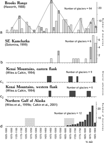
TABLE 1 Meteorological data for Alaska and Kamchatka lichenometry sitesa
TABLE 2a Control points for yellow Rhizocarpon growth curves in Alaska and Kamchatka
TABLE 2a (Cont.)
TABLE 2a (Cont.)
TABLE 2b Calibrated radiocarbon ages used for growth curve constructions for Alaska and Kamchatka
TABLE 3 Equations for new growth curves
TABLE 4 Lichen growth data estimated for new, calibrated curves
Acknowledgments
O. Solomina was partly supported by the U.S. Fulbright Foundation and the National Snow and Ice Data Center of CIRES, Boulder, Colorado. Ya. Muaviev, T. Shiraiwa, A. Belousov, M. Belousova, A. Ovsyannikov, K. Jamagata, and S. Sawaguchi supplied unpublished data. J. Grove provided early help and suggestions. P. Calkin drew on data obtained under several grants of the National Science Foundation, including ATM 9905493. We thank J. Ellis, L. (Haworth) Evison, G. Wiles, and D. Barclay for their many contributions to the Alaska lichenometry and chronologies, and G. Wiles and W. Karlén for review of an early manuscript. Al Werner and an unnamed reviewer also helped improve the paper but in no way are responsible for any problems still remaining.
References Cited
- Armstrong, R. A. 1974. Growth phases in the life of a lichen thallus. New Phytologist 73:913–918.
- Barclay, D. J. , P. E. Calkin , and G. C. Wiles . 2001. Holocene history of Hubbard Glacier in Yakutat Bay and Russell Fiord, southern Alaska. Geological Society of American Bulletin 113:388–402.
- Begét, J. E. 1994. Tephrochronology, lichenometry and radiocarbon dating at Gulkana Glacier, central Alaska Range, USA. The Holocene 4:307–313.
- Benedict, J. B. 1967. Recent glacial history of an alpine area in the Colorado Front Range, USA: establishing a lichen growth curve. Journal of Glaciology 6:817–832.
- Beschel, R. E. 1956. Lichenometrie im Gletschervorfeld (Lichenometry in glacier forefields). Jahrbuch des Vereins zum Schutze Alpenpflanzen und Alpentiere 22:164–185.
- Beschel, R. E. 1961. Dating rock surfaces by lichen growth and its application to glaciology and physiography. In Raash, G. O. (ed.), Geology of the Arctic, 2. Toronto: University of Toronto Press, 1044–1062.
- Bickerton, R. W. and J. A. Matthews . 1992. On the accuracy of lichenometric dates: an assessment based on the “Little Ice Age” moraine sequence of Nigardsbreen, southern Norway. The Holocene 2:227–237.
- Bijerk, A. 1980. Lichenometric dating of Neoglacial deposits in the deposits in the McKinley Park area, Alaska. Unpublished report submitted to the National Park Service and National Geographic Society. 55 pp.
- Bijerk, A. 1984. Holocene glacial history of the North-Central Alaska Range. Part 6. In Ten Brink, N. W. (ed.), North Alaska Range Project Final Report on 1978–1982, Geoarcheological Studies. Washington D.C.: National Geographic Society and National Park Service.
- Birkeland, P. W. 1981. Soil data and the shape of the lichen growth-rate curve for the Mt Cook area (Note). New Zealand Journal of Geology and Geophysics 24:443–445.
- Bull, W. 1996. Dating San Andreas fault earthquakes with lichenometry. Geology 24:111–114.
- Calkin, P. E. 1988. Holocene glaciation of Alaska (and adjoining Yukon Territory, Canada). Quaternary Science Reviews 7:159–184.
- Calkin, P. E. and J. M. Ellis . 1980. A lichenometric dating curve and its application to Holocene glacier studies in the central Brooks Range, Alaska. Arctic and Alpine Research 12:245–264.
- Calkin, P. E. and J. M. Ellis . 1984. Development and application of a lichenometric dating curve, Brooks Range, Alaska. In Mahaney, W. C., (ed.), Quaternary Dating Methods. Amsterdam: Elsevier, 227–246.
- Calkin, P. E. , D. S. Kaufman , B. J. Przybyl , B. Whitford , and B. J. Peck . 1998. Glacier regimes, periglacial landforms, and Holocene climate change in the Kigluaik Mountains, Seward Peninsula, Alaska, USA. Arctic and Alpine Research 30:154–165.
- Calkin, P. E. , G. C. Wiles , and D. J. Barclay . 2001. Holocene coastal glaciation of Alaska. Quaternary Science Reviews 20:449–461.
- Clague, J. J. , S. G. Evans , V. N. Rampton , and G. J. Woodsworth . 1995. Improved age estimates for the White River and Bridge River tephras, western Canada. Canadian Journal of Earth Science 32:1172–1179.
- Crossen, K. J. 1997. Neoglacial fluctuations of terrestrial, tidewater, and calving lacustrine glaciers, Blackstone-Spencer Ice Complex, Kenai Mountains, Alaska. Ph.D. dissertation, University of Washington, Seattle.
- Denton, G. H. and W. Karlén . 1973. Lichenometry: its application to Holocene moraine studies in Southern Alaska and Swedish Lapland. Arctic and Alpine Research 5:347–372.
- Denton, G. H. and W. Karlén . 1977. Holocene glacial and tree-line variations in the White River Valley and Skolai Pass, Alaska and Yukon Territory. Quaternary Research 7:63–111.
- Evison, L. H. , P. E. Calkin , and J. M. Ellis . 1996. Late-Holocene glaciation and twentieth-century retreat, northeastern Brooks Range, Alaska. The Holocene 6:17–24.
- Gordon, J. E. and M. Sharp . 1983. Lichenometry in dating recent glacial landforms and deposits, southeast Iceland. Boreas 12:191–200.
- Haworth, L. A. 1988. Holocene glacial chronologies of the Brooks Range, Alaska and their relationship to climate change. Ph.D. dissertation, State University of New York at Buffalo. 260 pp.
- Haworth, L. A. and P. E. Calkin . 1986. Direct measurement of lichen growth in the central Brooks Range, Alaska, U.S.A., and its application to lichenometric dating. Arctic and Alpine Research 18:289–296.
- Innes, J. L. 1982. Lichenometric use of an aggregated geographicum “species.”. Boreas 11:53–57.
- Innes, J. L. 1983. Use of an aggregated geographicum “species” in lichenometry: an evaluation. Boreas 12:183–190.
- Karlén, W. 1973. Holocene glacier and climatic variations, Kebnekaise Mountains, Swedish Lapland. Geografiska Annaler 55:29–63.
- Lock[e], W. W. , J. T. Andrews , and P. J. Webber . 1979. A manual for lichenometry. British Geomorphological Research Group: Technical Bulletin 26:47.
- Løken, O. H. and J. T. Andrews . 1966. Glaciology and chronology of fluctuations of the ice margin and the south end of the Barnes Ice Cap, Baffin Island, N.W.T. Geographical Bulletin 8:341–359.
- Luckman, B. H. and R. Villalba . 2001. Assessing the synchroneity of glacier fluctuations in the western Cordillera of the Americas during the last millennium. In Markgraf, Vera (ed.), Interhemispheric Climate Linkages. San Diego: Academic Press, 119–140.
- Matthews, J. A. 1974. Families of lichenometric dating curves from the Storbreen gletschervorfeld, Jotunheim, Norway. Norsk Geogrfisk Tidsskrift 28:215–235.
- Matthews, J. A. 1975. Experiments on the reproducibility and reliability of lichenometric dates, Storbreen gletschervorfeld, Jotunheimen, Norway. Norsk Geografisk Tidsskrift 29:97–109.
- Melekestsev, I. V. , O. A. Braitseva , V. V. Ponomareva , and L. D. Sulezhitsky . 1990. Vozrast I dinamika aktivnikh vulkanov Kuril'sko-Kamchatskogo regiona (Age and dynamics of active volcanoes in Kuril-Kamchatka region). Izvestiya Academii Nauk USSR (seria geol.) (Proceedings of the Academy of Sciences) 4:17–31.
- Melekestsev, I. V. , L. D. Sulerzhitski , L. I. Bazanova , O. A. Braitseva , and N. I. Florenskaya . 1995. Katastrofitcheskiye golotsenoviye lakhari Avachinskogo i Koriakskogo vulkanov na Kamchatke (Catastrophic Holocene lahars of the Avachinsky and Koriaksky volcanoes in Kamchatka). Vulkanologiya i Seismologiya (Volcanology and seismology) 4: –5. 172–181. (In Russian).
- Miller, G. H. and J. T. Andrews . 1972. Quaternary history of northern Cumberland Peninsula, east Baffin Island, N. W. T., Canada. Part IV: Preliminary lichen growth curve for. Rhizocarpon geographicum. Geological Society of America Bulletin 6:1133–1138.
- Péwé, T. L. and R. D. Reger . 1983. Delta River area, Alaska Range. In Péwé, T. L., and Reger, R. D. (eds.), Richardson and Glen Highways, Alaska: Guidebook to Permafrost and Quaternary Geology. Fairbanks: State of Alaska, 47–136.
- Reger, R. D. 1968. Recent history of Gulkana and College Glaciers, central Alaska Range, Alaska. Journal of Geology 76:2–16.
- Reger, R. D. and T. L. Péwé . 1969. Lichenometric dating in the central Alaska Range. In Péwé, T. L. (ed.), The Periglacial Environment: Past and Present. Montreal: McGill–Queens University Press, 223–247.
- Reger, R. D. and T. L. Péwé . 1991. Dating Holocene moraines of Canwell Glacier, Delta River valley, central Alaska Range: short notes on Alaskan geology. Alaska Division of Geological and Geophysical Survey: Professional Report III, 63–68.
- Savoskul, O. S. 1999. Holocene Glacier advances in the headwaters of Sredniya Avacha,. Kamchatka, Russia. Quaternary Research 52:14–26.
- Savoskul, O. S. and W. Zech . 1997. Holocene glacier advances in the Topolovaya Valley, Bystrinskiy Range, Kamchatka, Russia, dated by tephrochronology and lichenometry. Arctic and Alpine Research 29:143–155.
- Sawaguchi, S. , K. Muraviev Yamagata , D. Ya , and O. N. Solomina . 1999. Holocene glacier advances of Koryto Glacier, Kamchatka, Russia. In Naruse, R. (ed.), Cryospheric Studies in Kamchatka II. Hokkaido University, Japan, 79–84.
- Solomina, O. N. 1997. Holocene rapid mass movement in the former USSR: avalanches and mudflows. In Matthews, J. A., Frenzel, B., Glaser, B., and Weiss, M. (eds), Rapid Mass Movement as a Source of Climatic Evidence for the Holocene. Stuttgart: Jena, Lubeck, Ulm, 355–369.
- Solomina, O. N. 1999. Gornoye Oledeneniye Severnoy Evrasii v Golotsne (Mountain glaciation of northern Eurasia in the Holocene). Moscow: Nauchniy Mir. 264 pp. (In Russian.).
- Solomina, O. N. , YaD. Muraviev , and L. I. Bazanova . 1995. Little Ice Age glaciers in Kamchatka. Annals of Glaciology, 216: 240–244.
- Solomina, O. N. , YaD. Muraviev , K. Shiraivwa , and S. Sawaguchi . 1999. Lichenometric studies of moraines in Kronotsky Peninsula, Kamchatka, Russia. In Naruse R. (ed.), Cryospheric Studies in Kamchatka II. Hokkaido University, Japan, 76–78.
- Stuiver, M. 1982. A high-precision calibration of the A.D. radiocarbon timescale. Radiocarbon 4:1–26.
- Stuiver, M. and P. Reimer . 1993. Extended 14C database and revised CALIB radiocarbon calibration program. Radiocarbon 28:1022–1030.
- Ten Brink, N. W. 1983. Glaciation of the northern Alaska Range. In Thorson, R. M., and Hamilton, T. D. (eds), Glaciation in Alaska: Extended Abstracts from a Workshop. University of Alaska, Fairbanks: Alaskan Quaternary Center, 82–91.
- Ten Brink, N. W. 1984. North Alaska Range Project Final Report on 1978–1982, Geoarcheological Studies. Washington D.C.: National Geographic Society and National Park Service.
- Viereck, L. A. and E. L. Little Jr. . 1972. Alaska Trees and Shrubs. Agricultural Handbook 410, Forest Service, United States Department of Agriculture, Washington D.C. Reprinted by University of Alaska Press, 1986. 265 pp.
- Vinogradov, V. N. 1968. Katalog Lednikov SSSR, Kamchatka (Catalog of glaciers of the USSR, Kamchatka), vol. 20. Leningrad: Hydrometeoizdat, 2–4. (In Russian.).
- Watson, C. E. 1974. The climate of Alaska. In van der Eeder, F., and Troise, F. L. (eds.), Climates of the States—Western States, vol. 2. Port Washington, N.Y.: Water Information Center, 481–502.
- Webber, P. J. and J. T. Andrews . 1973. Lichenometry: a commentary. Arctic and Alpine Research 5:295–302.
- Wiles, G. C. 1992. Holocene glacial fluctuations in the southern Kenai Mountains, Alaska. Ph.D. dissertation, State University of New York at Buffalo. 333 pp.
- Wiles, G. C. and P. E. Calkin . 1994. Late Holocene, high-resolution glacial chronologies and climate, Kenai Mountains, Alaska. Geological Society of American Bulletin 106:281–303.
- Wiles, G. C. , D. J. Barclay , and P. E. Calkin . 1999a. Tree-ring dated Little Ice Age histories of maritime glaciers from western Prince William Sound, Alaska. The Holocene 9:163–174.
- Wiles, G. C. , A. Post , E. H. Muller , and B. F. Molnia . 1999b. Dendrochronology and late Holocene history of Bering Piedmont Glacier, Alaska. Quaternary Research 52:185–195.
- Wilson, J. E. and J. E. Overland . 1987. Meteorology. In Hood, D. W., and Zimmerman, S. T. (eds.), The Gulf of Alaska. Washington, D. C.: U.S. Department of Commerce and U.S. Department of Interior, 31–34.
- Zavaritsky, A. N. 1977. Vulkan Avacha na Kamchatke (Avacha Volcano in Kamchatka). Moscow: Nauka. 308 pp. (In Russian.).