Abstract
The physical and chemical limnological characteristics of 22 lakes and ponds in the remote region of Haughton Impact Crater, Devon Island, Nunavut, Canada, were explored. Our overall goals were to gather baseline information for use in climate and environmental change monitoring programs in the High Arctic as well as to compare these observations to other limnological surveys conducted in high-latitude regions. Study sites were alkaline (pHmean = 8.3), ultraoligotrophic (TPUmean = 3.7 μg L−1), and phosphorus limited. Major and minor ionic concentrations of most sites are comparable to other previously surveyed high arctic sites. Lakes and ponds in close contact with the impact-generated carbonate melt rocks associated with Haughton Crater were distinguished from the larger data set due to their elevated Mg2+, SO4 2−, Ba2+, Sr2+, and SiO2 concentrations. Selenite (CaSO4·2H2O) formations commonly associated with the lower levels of the carbonate melt sheets were identified as a likely source for the elevated SO4 2− concentrations in these sites. Principal Components Analysis separated sites along a conductivity and nutrient gradient on the primary and secondary axes, respectively. This study serves as a baseline for a long-term monitoring program in the Haughton Crater region.
Introduction
The High Arctic is a distinct region of our planet, unique in the manner in which it supports life, responds to shifts in the climate, and in turn influences environments at lower latitudes. Characteristics such as low incoming solar radiation, small land mass (one-tenth the size of tropical regions), and high-albedo surfaces exacerbate the effects of global climate change in the High Arctic compared to lower latitudes (CitationRoots, 1990; CitationRouse, 1993) and contribute to the region's environmental vulnerability. Furthermore, the effects of high arctic environmental change are not confined to this region because they are strongly tied to general oceanic and atmospheric circulation patterns and the modulation of global carbon budgets (CitationOverpeck et al., 1997). For example, an increase in the average annual discharge of arctic freshwater input to the Arctic Ocean over the period 1936–1999 has been correlated with changes in both the North Atlantic Oscillation and global mean surface air temperature (CitationPeterson et al., 2002). Given these elements, the High Arctic has become a critical reference area for global environmental change, and an area in need of long-term monitoring programs for effective study, analysis, and management.
Consistent and sustained monitoring of the High Arctic remains a challenge due to financial and logistical constraints; hence, ecological and environmental baseline data for much of this extreme region remain sparse. However, the large number of lakes and ponds found throughout the High Arctic can provide a means of establishing monitoring programs. These water bodies are particularly sensitive to environmental changes, including those operating on a global scale, which may or may not have been caused or accelerated by anthropogenic activities (CitationRouse et al., 1997; CitationDouglas and Smol, 2000; CitationVincent and Hobbie, 2000). For example, climate warming may induce changes in hydrology or catchment vegetation, resulting in concentration shifts of light-attenuating compounds (e.g., colored dissolved organic carbon) in high arctic water bodies, leading to increased solar ultraviolet ray penetration, increased ion and nutrient influx triggering greater productivity levels, and alterations to overall aquatic biodiversity and food web structure and dynamics (CitationDouglas and Smol, 1999; CitationHobbie et al., 1999; CitationVincent and Hobbie, 2000). Thus, establishing baseline data for high arctic lakes and ponds and subsequent monitoring is critical to our understanding of the effects of future climate changes in this region.
Although the importance of high arctic lakes and ponds has been widely recognized, the collection of even basic limnological data in the High Arctic is still in its infancy (CitationRouse et al., 1997; CitationVincent and Hobbie, 2000). An increase in research activity over the past decade has begun to rectify this situation. Some examples of recent collection and analysis of Canadian high arctic limnological data include CitationDouglas and Smol (1994), CitationAntoniades et al. (2000), and CitationHamilton et al. (2000), all from Ellesmere Island, Nunavut; CitationMichelutti et al. (2002b) on Victoria Island, Nunavut, and Lim et al. (in press) on Banks Island, Northwest Territories, both southwestern islands in the Canadian Arctic Archipelago; CitationMichelutti et al. (2002a) on Axel Heiberg Island, Nunavut; CitationLim et al. (2001) on Bathurst Island, Nunavut; CitationLudlam (1996) on Cornwallis and Ellesmere Island, Nunavut; CitationJoynt and Wolfe (2001) on Baffin Island, Nunavut; and CitationHamilton et al. (2001), who produced a limnological overview of 204 lakes from the Canadian Arctic Archipelago.
Even with this growing list of investigations, most of the High Arctic's lakes and ponds remain unexplored, including those found on Devon Island, Nunavut. Although some paleolimnological studies have been carried out on the island (e.g., CitationYoung and King, 1989; CitationGajewski et al., 1997; CitationNg and King, 1999), these have largely focused on selected lakes along the coast and in the Truelove Lowlands area.
Our sample sites are located in and around Haughton Crater because this study is part of a larger effort by the National Aeronautics and Space Administration/Search for Extraterrestrial Intelligence (Institute) (NASA/SETI) Haughton Mars Project (HMP) to map and characterize the biology and geology of this region of interest. Here we present an overview of the water chemistry data of 22 lakes and ponds from the Haughton Crater region of Devon Island, Nunavut (). Our objective was to conduct a comprehensive limnological survey of the Haughton Crater region that was comparable and complementary to surveys from other Canadian high arctic islands (e.g., CitationHamilton et al., 2001; CitationLim et al., 2001; CitationMichelutti et al., 2002a, Citation2002b). Haughton Crater is a unique setting in the High Arctic that offers the opportunity to explore the effects of a meteorite impact on the limnology of the surrounding water bodies. This study contributes to the advancement of the growing limnological database from the Canadian High Arctic and will play a key role in future paleolimnological investigations for this region.
Site Description
Devon Island is located in the eastern sector of the Canadian Arctic Archipelago. It is the world's largest uninhabited island (approximately 66,800 km2) and consists mostly of high plateau bordered in many places by sea cliffs and deep fiords (CitationThorsteinsson and Mayr, 1987). This plateau, drained mainly by short dendritic streams, is highest in the east, where it is approximately 1500 m a.s.l., and then gradually tilts down westward. The eastern portion of the island is distinguished by a large ice cap underlain by Precambrian crystalline rocks (CitationThorsteinsson and Mayr, 1987). The sites included in this study are located on the western portion of Devon Island, particularly the Haughton Crater area. This area is classified as Arctic Lowland, characterized by flat-lying sediments that become thicker northward, where they form smooth plateaus (CitationMaxwell, 1980). Phanerozoic sedimentary succession outcrops in the western portion of the island overlie crystalline rocks that are exposed in the eastern portion of Devon Island (CitationThorsteinsson and Mayr, 1987). Most of the Phanerozoic succession consists of lower Paleozoic rocks, overlain unconformably by widely separated outliers of Mesozoic and Tertiary sediments (CitationThorsteinsson and Mayr, 1987) estimated at 1885 m in thickness based on seismic reflection profiling (CitationScott and Hajnal, 1988). Haughton Crater (75°22′N, 89°40′W) is a circular impact structure 24 km in diameter that consists largely of much faulted lower Paleozoic (Ordovician-Silurian) carbonate formations overlain unconformably by what has been deemed to be impact breccia (up to 90 m thick in some areas) by CitationRedeker and Stöffler (1988) or carbonate-rich impact-melt rocks by CitationOsinski and Spray (2001). Shocked basement gneisses from Haughton Crater have been estimated at 23.4 ± 1.0 Ma through 40Ar–39Ar dating (CitationJessburger, 1988).
The Haughton Formation, which overlies the breccia in some distinct areas, is composed of up to 48 m of interbedded dolomite-rich lacustrine silt, fine sand, and mud (CitationHickey et al., 1988). These paleolake deposits contain a rich assemblage of pollen, plant macrofossils, and the only known record of early Neogene arctic vertebrates (CitationWhitlock and Dawson, 1990). Pinus, Picea, Tsuga, Larix, Betula, Alnus, and Corylus were found to be the most abundant pollen types in the Haughton lacustrine remains (CitationHickey et al., 1988; CitationWhitlock and Dawson, 1990) and are comparable to modern-day pollen distributions associated with mixed conifer-hardwood forests of eastern coastal North America. Herbaceous taxa are nearly absent, and Gramineae pollen are entirely absent. Since grasses began appearing in the southwestern portion of Canada during the early Miocene, the lack of grass pollen in the Haughton Formation stratigraphies suggests an early Miocene date consistent with the time span representing the limits of error of the date for the impact event (CitationHickey et al., 1988).
Like other high arctic sites, this region is characterized by a continuous permafrost layer. The western portion of Devon Island, including the area of Haughton Crater, is classified as a polar rock desert, or fellfield, and is characterized by cryic regosol, shallow soils without significantly developed genetic horizons (CitationMaxwell, 1980). These soils are often characterized by arid features, including salt crusts, alkali flats, and carbonate accumulations, which serves to increase surficial pH up to 9.0 (CitationMaxwell, 1980). Most of the Haughton Crater area is largely unvegetated, but portions are inhabited by herbaceous species such as Oxyria digyna, Oxytropis arctica, Saxifraga oppositifolia, and Papaver lapponicum, with the occasional presence of low-lying dwarf shrubs such as Salix arctica. CitationCockell et al. (2001) determined that the alluvial terraces in the Haughton Crater area had vegetation cover that ranged from 2 to 11%, whereas the breccia hills were less vegetated with a coverage range of 0.1 to 0.3%. Also found throughout the Haughton Crater region are several isolated microoases, demonstrating enhanced local fertility relative to their surroundings, with vegetation cover ranging from 15 to 73% on the breccia and 2 to 98% on the alluvial terraces (CitationCockell et al., 2001). Overall, these microoases are dominated by either graminoids and Stellaria longipes or bryophytes and Draba corymbosa (CitationCockell et al., 2001). Seepage and snow-free south-facing slopes, as well as sheltered valleys, are examples of distinct hydrological features that contribute to increased water and nutrient supply to specific areas, resulting in small regions of enhanced vegetation growth (CitationEdlund and Alt, 1989). Although these oases are considered to be small-scale features, they may nonetheless have a significant impact on the limnology of nearby water bodies.
Annual mean daily temperature on Devon Island from the closest weather station (approximately 175 km from Haughton Crater) at Resolute, Cornwallis Island, Nunavut (74°43'N, 94°59'W) is −16.6°C (data were collected over the period of 1947 to 1990 and tabulated by CitationEnvironment Canada [1990]). Mean July temperature, which is on average the warmest month of the year and the height of the ice-free growth season, is estimated at 4.0°C. Mean annual precipitation is 139.6 mm.
Materials and Methodology
SAMPLING AND ANALYTICAL METHODS
A total of 22 lakes (>2 m depth) and ponds (<2 m depth) were sampled via ground-based and helicopter-assisted transects around Haughton Crater, Devon Island, Nunavut, over the period 8–29 July 2000 (). Lakes are distinguished from ponds in this study because differences in their physical properties (e.g., depth, volume, extent of ice cover) affect their thermal and chemical inertia and probably their water chemistry as well. For example, ponds may experience greater impacts and fluctuations in their thermal and chemical regimes, whereas lakes may be more chemically stable due to their greater volumes. All lakes and ponds were unnamed and were thus assigned unofficial alphabetic designations of DA to DV (D = Devon). Sites were sampled over a short time frame (3 wk) in order to minimize variability due to seasonal fluctuations. A total of 39 limnological variables (both field and laboratory) were measured for each site.
Site DA was sampled again later in the field season (11 d after initial sampling on 11 July 2000) in three separate areas of the lake in order to observe possible seasonal changes and check for within-lake patchiness. These three data points, labeled DA-1, DA-2, and DA-3, were also measured for the full limnological suite and are included in , the Pearson correlation matrix (), and the PCA ordination (). Sample DA-3 was collected at the same geographical point of the lake as the original sample DA in order to have a direct source of comparison. These three data points will be referred to as “subsites” hereafter.
Sites were selected to cover as wide an environmental gradient as possible (e.g., proximity to sea, drainage characteristics, vegetation, elevation), with latitudinal and longitudinal data for each site being recorded using a handheld global positioning system (GPS). Approximate elevation values for each site were recorded from 1:50,000 topographic maps. Sampling procedures for this study followed routine techniques as described by CitationDouglas and Smol (1994) and CitationPienitz et al. (1997) and are briefly detailed below.
Lake and pond temperatures were measured from approximately 0.3-m water depth at each site to the nearest 0.5°C using a handheld thermometer. Unfiltered water samples for major/minor ion analyses and samples for trace metal analyses were collected from approximately 0.3-m depth at each site using precleaned 250-mL Nalgene® bottles rinsed three times with sample site water prior to collection. Lake and pond (unfiltered) samples were collected at each site for total unfiltered phosphorus (TPU) using prewashed 250-mL glass bottles. Water samples for nutrient analyses of total chlorophyll a, particulate organic carbon (POC), particulate organic nitrogen (PON), and other minor nutrient constituents, along with pH and specific conductance (COND) measurements, were partitioned and prepared from 1-L Nalgene® bottles within hours of sample collection. Conductivity and pH readings for each site were also recorded from these unfiltered samples.
For some analyses, water samples were prepared by filtration, with the filtrate being collected in acid-rinsed 125-mL glass bottles for the subsequent analysis of total “dissolved” phosphorus (TPF), nitrite (NO2), nitrate (NO3), ammonia (NH3), soluble reactive phosphate-phosphorus (SRP), dissolved organic carbon (DOC), dissolved inorganic carbon (DIC), and total Kjeldahl nitrogen (TKN). Water samples were also filtered for POC, PON, and total chlorophyll a (CHLA-U) as an estimate of biomass.
All samples were stored in a cool, dark area for the duration of the field season and subsequently shipped to the National Water Research Institute in Burlington, Ontario, where all water chemistry analyses were conducted following standard protocols outlined by Environment Canada (1994a, 1994b).
STATISTICAL ANALYSES AND DATA SCREENING
Principal Components Analysis (PCA) was performed using the statistical program CANOCO v. 4 (Citationter Braak and Šmilauer, 1998) in order to detect dominant patterns and environmental relationships in the limnological data set (CitationJongman et al., 1987; Citationter Braak and Prentice, 1988). PCA was also utilized to identify outlier sites falling outside the 95% confidence limits as determined from the site score means. No sites were identified as being outliers, so all sample sites from the Haughton Crater region were included in these statistical analyses.
Those environmental variables that were recorded as being below the detection limit (limits ranged from <0.0002 mg L−1 to <0.2 mg L−1) in more than 50% of the study sites were removed from the data set used in the PCA. This resulted in the elimination of Be2+, K+, Cd2+, Co2+, Cr2+, V2+, Mo2+, Mn2+, Pb2+, Ni2+, Li+, Ag+, NO2, NO3NO2, and NH3. Therefore, from the original 39 measured variables, a total of 24 chemical and physical variables were included in the final active environmental data set (). Other variables that contained measurements below the detection limits in less than 50% of the sites were not removed from the data set but rather replaced with a value of half of the measured detection limit for that variable. The values that have been replaced in this manner have been boldfaced in . The TPU value for site DB was disregarded in our study due to an analytical lab error.
A Pearson correlation matrix with Bonferroni adjusted probabilities was used to distinguish pairs of significantly (0.01 ≥ P ≤ 0.05) correlated environmental variables (). The program CALIBRATE v. 0.3 (CitationJuggins and ter Braak, 1992) was used to identify skewness in the distribution of each individual variable. All of the environmental variables except Ca, TPU, CHLA-U, and COND were normalized in order to reduce skewness by performing either log (x) (Na, SO4, Cl, Al, Ba, Fe, Sr, SiO2, DOC, DIC, POC, TPF, TKN, pH) or square root (Mg, Cu, Zn, SRPF, PON, TEMP) transformations. This transformed data set was used in both the PCA ordination and the Pearson correlation matrix.
Results and Discussion
PHYSICAL VARIABLES
Of the 22 sites sampled around the Haughton Crater area, 12 were ponds that typically freeze to the bottom, and 10 were characterized as lakes that maintain liquid water under the ice. With the exception of DQ and DR, these sites were focused within a 20-km radius of the HMP base camp () and were all within a small elevation gradient ranging from sea level to approximately 240 m a.s.l. ().
Temperature (TEMP) values for all 25 data collection points ranged from 1.5°C to 15.0°C (mean = 7.0°C). Pond temperatures ranged from 3.0°C to 15.0°C, while lake temperatures ranged from 1.5°C to 13.0°C, with the three additional samplings of site DA later in the field season ranging from 9.0°C to 11.0°C. Like other high arctic sites (e.g., CitationLim et al., 2001, CitationMichelutti et al., 2002b), the mean temperature for the sampled ponds (mean = 7.7°C) is higher than the mean temperature for the lakes (mean = 4.7°C). This difference is attributed to the greater heat capacity of lakes versus smaller, shallower water bodies such as ponds.
CHEMICAL VARIABLES
pH, Conductivity, and Major/Minor Ions
The pH values for the lakes and ponds in the Haughton Crater region did not vary greatly, ranging from 8.0 to 8.6 (mean pH = 8.3). The tight range in pH values was not surprising given that all of the sample sites were underlain by similar carbonate bedrock. Furthermore, the alkaline mean pH for the Haughton Crater region water bodies is similar to pH values from other lakes and ponds on Devon Island (CitationHamilton et al., 2001) and nearby islands with comparable surficial geology and/or bedrock such as Bathurst Island (CitationLim et al., 2001), Cornwallis Island (CitationDouglas and Smol, 2000; Smol, unpublished data) and Ellesmere Island (CitationDouglas and Smol, 1994; CitationAntoniades et al., 2000).
Ponds DJ (pH = 8.5), DQ (pH = 8.6), and DR (pH = 8.5) had the highest recorded pH values (). Given that these sites are underlain by bedrock similar to that underlying all other sites in the study, this characteristic may be attributable to their respective levels of photosynthetic activity and their size. The bottom of each of these sites was lined by rocks covered with a thick cyanobacterial mat, which through photosynthetic activities may have contributed to the elevated pH levels. Subsites DA-1 (pH = 8.6), DA-2 (pH = 8.4), and DA-3 (pH = 8.4) increased slightly in pH compared to the initial collection at the lake (DA pH = 8.3). Once again, this slight increase may be attributable to an increase in overall lake productivity; however, given that this lake and all other Haughton Crater sites are well buffered, it is not surprising that the effects of biotic activity on lake alkalinity might be muted.
Conductivity levels ranged from 50 μS cm−1 to 185 μS cm−1, with a mean of 97 μS cm−1 (). The minimum value of 50 μS cm−1 was recorded in lake DE, which was approximately 7 m in depth, was devoid of any vegetation both without and within its catchment area, and drained through dry, rocky felsenmere. The maximum conductivity value of 185 μS was recorded in pond DR, a small water body located near the sea at Thomas Lee Inlet (). Overall, this site had numerous elevated environmental variables, including the maximum recorded values for Na+, Cl−, Zn2+, and bicarbonate (HCO3−) ions (). Although the mean value for the sampled lakes (meanlakes = 92.4 μS) was less than the mean for the sampled ponds (meanponds = 100.2 μS cm−1), as is typically expected, the difference between these two values was not as distinct as has been commonly recorded in other high arctic surveys, where lake conductivity mean values are usually substantially lower then those for ponds (e.g., CitationMichelutti et al., 2002b). Lakes DT, DU, and DV, in particular, contributed to raising the mean lake conductivity value. Specifically, sites DT (145 μS), DU (145 μS), and DV (150 μS), although large lakes, all had specific conductance values above the data set mean (meandata set = 97 μS cm−1) (). The elevated conductivity value for site DV, a large lake visible on the 1:500,000 VFR Navigation Chart, can be attributed to its close proximity to the ocean (approximately 50 m from the coast; 10 m a.s.l.), which may have acted as a point source for incoming marine aerosols. Sites DT and DU, however, were not in close proximity to the sea. Their elevated conductivity levels may be due, in part, to their proximity to impact-generated carbonate breccia-melt hills, which form part of their catchment area (). Drainage through these hills has resulted in the elevated Ca2+ and bicarbonate concentrations at these sites relative to other lakes and ponds in the area. Other ionic constituents such as Mg2+, SO4 2−, Ba2+, Sr2+, and SiO2, which, with the exception of Mg2+, were all positively and significantly (P ≤ 0.01) correlated to each other and COND (), were also higher than their respective means in these sites. Their elevated concentrations may similarly reflect drainage effects through the melt hills, which are largely comprised of dolomite, calcite, and Si-Mg-Al-rich glasses (CitationOsinski and Spray, 2001). Furthermore, tabular plates and prismatic formations of selenite (CaSO4·2H2O), a transparent form of gypsum that is commonly associated with the lower levels of the carbonate melt sheets throughout Haughton Crater (CitationOsinski et al., 2001), may have been in contact with the lakes, providing a source for the elevated sulfate levels in DT and DU. Although much of the incoming water into these sites presently comes from snow and spring icemelts, these water bodies may nevertheless have been in existence since the last glacial retreat from this area approximately 8 ka B.P. (CitationDyke, 1999). Therefore, a sufficient period of time may have elapsed to allow these lakes and ponds to interact with the local catchment, hence dissolving the selenite structures. Interestingly, ponds DJ and DK, the only other sampled sites lying next to carbonate melt hills similar to those flanking lakes DT and DU, also have elevated Mg2+, SO4 2−, Ba2+, Sr2+, and SiO2 concentrations relative to the respective means ().
The concentrations of all major (Ca, Mg, Na, Cl, HCO3 [DIC], SO4) and minor (Ba, Sr) ions were within the natural ranges of Canadian inland surface waters (CitationMcNeely et al., 1979), although somewhat on the low end. The relative concentration of the cations was Ca > Mg > Na > Sr, with means of 21.6 mg L−1, 6.1 mg L−1, 1.7 mg L−1, and 0.06 mg L−1 respectively, while that of the anions was HCO3 > SO4 > Cl, with means of 16.7 mg L−1, 5.0 mg L−1, and 4.0 mg L−1 respectively (). These relative concentrations for the Haughton Crater sites are similar to those reported by other high arctic limnological surveys such as CitationHamilton et al. (2001), CitationLim et al. (2001), and CitationMichelutti et al. (2002a, Citation2002b). Pond DK and lake DV do not, however, follow the overall relative concentration order of HCO3 > SO4 > Cl, but rather show sulfate as their dominant anion followed by bicarbonate and chloride. As discussed earlier, these two sites are in close contact with sulfate-bearing minerals and incoming marine aerosols, respectively, which most likely contributed to their elevated SO4 levels relative to other sites.
Metals
Four metals (Al, Fe, Cu, and Zn) were considered in this study, as they had concentrations above their detection limit in over 50% of the sample sites (). With the exception of Fe, mean concentrations for each of these metals were within the natural ranges reported for Canadian inland waters (CitationMcNeely et al., 1979). The typical iron concentrations in aerated surface waters are listed as usually being less than 0.5 mg L−1. The mean Fe value for the Haughton Crater sites is 0.05 mg L−1 (), which is comparable to those reported by CitationMichelutti et al. (2002a, Citation2002b) for Axel Heiberg (Fe mean = 0.03 mg L−1) and Victoria (Fe mean = 0.02 mg L−1) Islands. The maximum values for Al (0.72 mg L−1), Fe (0.77 mg L−1), and Cu (0.011 mg L−1) were all recorded in site DD, which is a small, possibly ephemeral pond, approximately 30 m from site DA ().
Carbon Measurements
Dissolved inorganic carbon (DIC) values in the Haughton Crater area ranged from 9.4 mg L−1 to 22.8 mg L−1 with a mean value of 16.7 mg L−1 (). This range and mean concentration for DIC is comparable to those recorded on other Canadian high arctic islands by CitationAntoniades et al. (2000), CitationLim et al. (2001), and CitationMichelutti et al. (2002a, Citation2002b). From a limnological sampling of 170 sites in the High Arctic, CitationHamilton et al. (2001) also reported a similar, although slightly higher, mean of 21.7 mg L−1. This similarity in mean reported DIC values reflects the underlying carbonate bedrock common to many islands in the High Arctic.
Dissolved organic carbon (DOC) concentrations ranged from 1.2 mg L−1 to 7.4 mg L−1, with a mean of 2.2 mg L−1 (), which is at the lowest end of the DOC spectrum for Canadian natural inland waters (CitationMcNeely et al., 1979). This mean is comparable to values reported for ultraoligotrophic sites near Wynniatt Bay, Victoria Island (CitationMichelutti et al., 2002b) (mean = 1.46 mg L−1), as well as near Alert, Ellesmere Island (CitationAntoniades et al., 2000) (mean = 2.0 mg L−1). This reflects the consistent lack of vegetation in the catchment areas of the sampled lakes and ponds in this study, with the exception of site DR, where we recorded the maximum DOC concentration of 7.4 mg L−1. Relative to all of the other sampled lakes and ponds in the Haughton Crater region, pond DR clearly differentiated itself based on its lush catchment area, low relief, and dark colouring. Although all the other sites were extremely clear, the water in pond DR had a strong “tea” color. High occurrences of goose scats and musk-ox tracks at this site indicated that pond DR was heavily visited by local wildlife. This activity may have been a source of nutrient enrichment to the pond, encouraging vegetational growth and photosynthetic activity in the aquatic system and resulting in the higher DOC concentrations.
DOC levels have been identified as one of the key controlling factors in determining the level of underwater penetration of solar ultraviolet radiation (UVR) into aquatic systems (reviewed by CitationVincent and Pienitz, 1996). DOC strongly absorbs the more biologically damaging, shorter UV wavelengths (CitationScully and Lean, 1994), thus acting as a naturally occurring sunscreen in lakes and ponds. In the clear, ultraoligotrophic lakes and ponds in the Haughton Crater area, low DOC levels would allow for high penetration levels of UVR.
Nutrients (Nitrogen and Phosphorus)
TKN is a measure of ammonia and organic nitrogen, both of which are key to the assessment of available nitrogen for biological activities (CitationMcNeely et al., 1979). TKN ranged from 55.0 μg L−1 to 716.0 μg L−1, with a mean concentration of 127.0 μg L−1 (). The TKN mean is comparable to that recorded by CitationMichelutti et al. (2002b) (mean = 150 μg L−1) and CitationLim et al. (2001) (mean = 112 μg L−1) on Victoria and Bathurst Islands, respectively. NO3NO2 was below detection levels in all sites, while TN (TKN + PON) ranged from 63.0 μg L−1 to 777.0 μg L−1 (mean = 148.4 μg L−1). TN concentrations were below the mean in the lakes (meanlakes = 105.0 μg L−1), whereas the mean TN for ponds, driven by site DR having the maximum recording TN level at 777.0 μg L−1, was higher (meanponds = 195.0 μg L−1) (). With the removal of DR, the mean TN for ponds decreases to 141.82 μg L−1, which is still greater than that for the lakes alone. As previously noted (see “Carbon Measurements” section), this shallow pond was highly vegetated compared to the other Haughton Crater sites and most likely received nitrogenous inputs from fecal matter deposited within its catchment. Furthermore, due to its shallowness, wind agitation and wildlife activity may also have played a dominant role in reintroducing nitrogen found in the pond sediment back into the water column.
Some temporal and spatial variability was observed at site DA. TN increased by 18 μg L−1 over an 11-d period at sample point DA/DA-3. Specifically, the initial TN value at DA was 93.0 μg L−1, while that for DA-3 had risen to 111.0 μg L−1. Subsite DA-1 (127.0 μ L−1) also increased in TN relative to DA, while subsite DA-2 was lower at 90.0 μg L−1. The difference in TN concentrations around the lake may be a result of variance in local runoff inputs.
The mean TPU concentration of 3.7 μg L−1 (range = below detection limit [<0.2 μg L−1] to 8.7 μg L−1) indicates that most of the lakes and ponds in the Haughton Crater region can be classified as ultraoligotrophic (CitationVollenweider, 1968). Although not as low as the mean TPU value reported for Victoria Island by CitationMichelutti et al. (2002b), the Haughton Crater mean is approximately three times less than that reported by CitationHamilton et al. (2001) for 173 sampled lakes and ponds across the Canadian High Arctic. Pond DR had the maximum recorded concentration of TPU at 8.7 μg L−1, which, coupled with its elevated TN concentration, confirms that it is the most nutrient-enriched site of the data set. Excluding pond DB, the sites with the lowest TPU levels were lakes (DE, DG, and DH).
Chemical and physical characteristics play an important driving role in determining the biota that live within an aquatic environment. In order to identify the primary limiting nutrient for phytoplankton in the Haughton Crater area lakes and ponds, a series of nitrogen-to-phosphorus ratios were calculated. Specifically, TN-to-TPU ratios (TN:TPU) were examined.
The TN:TPU ranged from 12:1 (DF) to 91:1 (DH), with a mean of 43:1 (). This is comparable to the TN:TPU ranges reported by other arctic limnological surveys (e.g., CitationPienitz et al., 1997; CitationGregory-Eaves et al., 2000; CitationLim et al., 2001). Based on guidelines by CitationSakamoto (1966) listing lakes with TN:TP greater than 17 as being P-limited, the mean ratio for the Haughton Crater systems indicates P-limitation. Only one site, DF (12:1), had TN:TP significantly outside this P-limitation guideline.
BIOTIC COMPONENTS
Chlorophyll a (CHLA-U) concentrations ranged from below the detection limit (<0.1 μg L−1) in lake DI to 1.60 μg L−1 in pond DN, with an overall mean of 0.8 μg L−1 (). This small range is similar to that reported by CitationMichelutti et al. (2002b) for the ultraoligotrophic water bodies on Victoria Island.
CHLA-U was not significantly (P ≤ 0.05) correlated with TKN or TPU (); therefore although ratio analyses would indicate that the majority of the sites are P-limited, other variables may also be affecting the phytoplankton productivity in the Haughton Crater lakes and ponds.
POC-to-CHLA-U (POC:CHLA-U) ratios were calculated () in order to estimate whether the POC in the sites was mostly derived from algal or terrestrial/detrital sources. The range for the Haughton Crater sites was 139:1 to 5300:1, with a mean of 888:1. CitationEppley et al. (1977) suggested that lakes with POC:CHLA-U ratios greater than 100 would derive most of their POC from terrestrial/detrital sources. Therefore, our study sites are on average receiving the majority of their POC from allochthonous inputs, like lakes and ponds from other regions in the high arctic (CitationHamilton et al., 2001). The POC:CHLA-U for site DT (196:1) is significantly lower than both the mean and the ratio for neighboring site DU (2990:1). Furthermore, lake DT had a CHLA-U concentration of 1.5 μg L−1, which is higher than both the mean and the [CHLA-U] value reported for the nearby site DU (0.1 μg L−1). DT is likely not receiving as much terrestrial/detrital inputs from its watershed as lake DU, so algal and other autochthonous inputs from within the lake are most likely the dominant contributors to POC concentrations in this particular lake. Lake DU, in comparison, most likely receives heavy seasonal pulses of allochthonous inputs from the inflow channel connecting it with DT, as reflected by its high POC:CHLA-U. Therefore, algal productivity in DU may be lower than in DT.
PRINCIPAL COMPONENTS ANALYSIS (PCA)
PCA was used to detect dominant trends and relationships between sites and environmental variables (). Environmental variables are represented by arrows, while sites are marked by points on the biplot. Arrow lengths, as well as their angles relative to axis 1 and 2, illustrate the relative weight of a particular environmental variable in determining the construction of the ordination axes (Citationter Braak and Prentice, 1988). Furthermore, the angles between the arrows are representative of the degree of correlation between environmental variables. The chemical composition of any given site can be inferred from the ordination based on the projection of site scores in relation to the environmental arrows (CitationJongman et al., 1987). That is, those sites clustered together will share similar characteristics, while those at opposite spectra to each other will be vastly different.
Axis 1 of the PCA accounted for 38.4% of the cumulative percentage variance in the data set, while axis 2 comprised the remaining variance totaling 55.3% in cumulative value. Eigenvalues for axes 1 and 2 were λ1 = 0.38 and λ2 = 0.17, respectively. Differences in conductivity (COND) (especially with respect to Ca2+, Ba2+ and HCO3 − [DIC] levels) along axis 1 and nutrient and carbon inputs (TKN, PON, DOC), and to a lesser degree metal content (Zn, Al), along axis 2 were the dominant limnological gradients identified by the PCA () that drive the distribution of the 25 sample points. Species scores () revealed that the variables with the strongest effect on the construction of axis 1 were, in order of decreasing strength, COND, Ca, DIC, Ba, and SO4. Axis 2 was most strongly affected by Zn, TKN, PON, and DOC (). Generally, the deeper sites from the Haughton Crater area tended to cluster and ordinate separately from the shallower water bodies based on these key environmental gradients. Specifically, 6 of the 10 lakes ordinate in the left half of the PCA, while 9 of the 12 ponds are projected onto the right half of the ordination (). This separation may represent overall differences in ionic and nutrient concentrations between the dilute lakes and the relatively more concentrated shallow ponds.
Conductivity (COND), more specifically Ba, SO4, Ca, and DIC, had the strongest influence on the construction of axis 1 as illustrated by the arrow lengths and close relationship to this axis (). These four ionic constituents also show a high positive correlation with pH, SiO2, and Sr. These relationships are also supported by the results of the Pearson correlation matrix (), which shows significant (P ≤ 0.05) positive correlations between all of these values. Sites DJ, DK, DT, DU, and DV all have COND levels above the mean (), and most notably, they have elevated [SO4] which accounts for their clustering and association with these particular variables on the PCA ordination (). However, it is most likely slight variations in TKN, PON, and DOC concentrations that are driving the differences amongst these sites. For example, sites DJ and DK both have TKN, PON, and DOC values near or above the means, while sites DT, DU, and DV, which are projected lower on the PCA than DJ and DK, have TKN, PON, and DOC values near or below the means ().
As expected, pond DR ordinates in the upper right quadrat, in close association with the nutrient gradient extremes driving axis 2 (). This site posted the maximum recorded DOC, TKN, PON, TPU, and TPF concentrations in the data set (). Pond DR differentiated itself against the other sample sites based on the lushness of its catchment area and its low relief. Its high DOC concentration is most likely the result of humic-loaded terrestrial runoff into this pond. Together the POC:CHLA-U (1288:1) for DR and the correlation (P ≤ 0.05) between POC and DOC also indicate that terrestrial/detrital sources from the catchment are most likely responsible for the majority of the inputs into this pond. Therefore, axis 2 most likely also reflects minor variations in the level of allochthonous inputs amongst the sites. CitationMichelutti et al. (2002a) reported a similar gradient in their PCA ordination of 38 lakes and ponds on Axel Heiberg Island, which lies to the northwest.
The sites that ordinate in the upper left quadrat of the PCA ordination (DE, DF, DG, DH, DI, DO, DP, and DS), in the opposite direction to the ionic gradient extremes, are clustered together based on their similarly low Ca, Ba, SO4, HCO3 (DIC), and COND values (). All of these ionic variables were below their mean concentrations in each of these sites (). This cluster of sites had similarly unvegetated, rocky catchments and steep surrounding relief. Interestingly, 6 of the 8 sites clustered in the upper left of the ordination are deeper lakes, and in addition to pond DP are all located to the northeast of base camp at varying distances (). All of these lakes had temperatures below the mean (mean = 7.0°C). Also, with the exception of the two smallest lakes, DF and DI, which may have both just become ice free, all of these lakes were still >40% ice covered at the time of sample collection. No other sites in the data set had ice on their surfaces during the sampling period. Meltwater derived from thawing ice cover may have caused these sites to be become diluted in ionic constituents relative to the other lakes and ponds in the Haughton Crater area.
Ponds DM, DN, and DO, all from a similar geographic region in the crater area (), ordinate on the two left quadrats of the PCA ordination away from the COND and nutrient gradient extremes (). Although it is expected that ponds will typically be warmer, higher in COND, and more nutrient rich than lakes (e.g., CitationLim et al., 2001), these shallow ponds were unusually cold (TEMP values < mean of 7.0°C), oligotrophic (TPU values < mean of 3.7 μg L−1) and dilute (COND values < mean of 97.0 μS cm−1) compared to the other sites (). As discussed earlier in this section, axis 2 probably also reflects small variations in terrestrial/detrital inputs. Therefore, these three ponds most likely receive less nitrogen, phosphorus, and DOC inputs from local runoff than the other lakes and ponds in the area. These ponds also ordinate in close association with the weak CHLA-U gradient that extends along the negative portion of axis 1 (). CHLA-U concentrations for DM (1.0 μg L−1), DN (1.6 μg L−1), and DO (0.9 μg L−1) are all above the mean (0.8 μg L−1), with DN posting the maximum recorded CHLA-U value in the data set (). POC:CHLA-U for these sites are all below the mean (888:1), indicating that (1) these sites receive less terrestrial input versus other sites, and (2) a higher proportion of the POC concentrations in DM, DN, and DO are attributable to algal biomass than in the other Haughton Crater lakes and ponds.
The weak metal gradient associated with axis 2 () is most likely the dominant characteristic differentiating site DD from the rest of the data set. As discussed in the “Metals” section, pond DD had the maximum Al, Cu, and Fe concentrations in the data set (), which accounts for the projection of this site at the extreme of the metal gradient (). DD also had COND slightly above the mean and the maximum recorded [Ca] and [Mg] values, resulting in its being ordinated in the right portion of the ordination, in a positive association with axis 1 ().
Interestingly, site DA and subsites DA-1, DA-2, and DA-3 ordinated in close proximity to each other, indicating that although COND and nutrient concentrations may have increased through the ice-free season, on the whole the limnological properties of this lake remained constant.
Conclusions
Overall, the physical properties of the lakes and ponds in the Haughton Crater area were similar to those reported by previous limnological surveys from the High Arctic. However, the presence of impact-generated carbonate melt rocks in the Haughton Crater area has affected the conductivity levels, specifically the Mg2+, SO4 2−, Ba2+, Sr2+, and SiO2 concentrations, in sites that are in close association with this substrate. Selenite (CaSO4·2H2O) formations, commonly associated with the lower levels of the carbonate melt sheets, are likely the source of elevated SO4 2− concentrations in four sites (DJ, DK, DT, and DU) that were in direct contact with them.
In general, the lakes and ponds in the Haughton Crater area were extremely clear, with their mean DOC (mean = 2.2 mg L−1) being one of the lowest reported averages in the High Arctic. The lakes and ponds were classified as ultraoligotrophic aquatic systems, and TN:TPU analysis revealed that most of the Haughton Crater area lakes and ponds may be P-limited. During the initial thaw period, meltwater from surface ice can serve to dilute ionic and nutrient concentrations in lake waters, while later in the season warmer temperatures and greater evaporation rates may result in an overall increase in lake concentration levels. Lake DA, for example, was resampled later in the summer field season and showed increases in conductivity levels and nutrient concentrations similar to the seasonal trends recorded from sites on Cape Herschel by CitationDouglas and Smol (1994).
The first two axes of the PCA ordination account for 55.3% of the limnological variation among the study sites. Axis 1 (λ1 = 0.38) was driven primarily by COND, while axis 2 (λ2 = 0.17) represented a nutrient and carbon concentration gradient. Key limnological patterns among the sites, such as chemical and nutrient similarities between deeper, semi-ice-covered lakes, were further elucidated by the ordination.
This limnological study will form the foundation of a long-term aquatic environmental monitoring program to be established by the authors in the Haughton Crater area in association with colleagues at the NASA/SETI Haughton Mars Project.
FIGURE 1. Map of Devon Island and the Haughton Crater region, with the location of the 22 lakes and ponds in this limnological study. Crater rim interpolated from 10-m contour intervals of 1:50,000 Canada NTS map No. 58 H/7
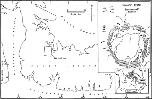
FIGURE 2. Photograph showing catchment area of lakes DT and DU
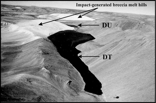
FIGURE 3. PCA of 24 environmental variables and 25 Haughton Crater sites and subsites
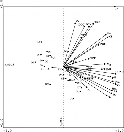
Table 1 Environmental data set for all collection points (n = 25) sampled in the Haughton Crater region. Measurements below the detection limit were replaced with a value of half the measured detection limit for each specific variable and are listed in bold typeface
Table 1 extended
Table 2 Pearson correlation matrix for transformed environmental data with Bonferroni adjusted probabilities of the 22 sites and 3 subsites (DA-1, DA-2, DA-3) included in the PCA
Table 3 Species scores indicating the correlative strength of the environmental variables to PCA axes 1 and 2. Those variables with the strongest correlations to each axis are boldfaced
Acknowledgments
We are grateful for the financial support of NSERC for the research grant of M. S. V. D., as well as the Northern Scientific Training Programme (NSTP), Ontario Graduate Scholarships (OGS), and University of Toronto Fellowships awarded to D. S. S. L. Additional support came from the NASA Haughton Mars Project (HMP) and the Polar Continental Shelf Project (PCSP). P. C. Lee, in particular, and other members of the 2000 HMP season are also to be thanked for their tireless support and assistance. We would like to give our thanks to D. Antoniades, C. Cockell, and J. P. Smol for their input on earlier drafts of this paper as well as J. R. Glew for his contribution of . This is PCSP contribution #006-03.
References Cited
- Antoniades, D. , M. S V. Douglas , and J. P. Smol . 2000. Limnology and autecology of freshwater diatoms from Alert, Northern Ellesmere Island, Nunavut. Proceedings of the 6th National Student Conference on Northern Studies, 1–11.
- Cockell, C. S. , P. Lee , A. Schuerger , L. Hidalgo , J. A. Jones , and M. D. Stokes . 2001. Microbiology and vegetation of micro-oases and polar desert, Haughton impact crater, Devon Island, Nunavut, Canada. Arctic, Antarctic, and Alpine Research 33:306–318.
- Douglas, M. S V. and J. P. Smol . 1994. Limnology of high arctic ponds (Cape Herschel, Ellesmere Island, N. W. T). Archive für Hydrobiologie 131:401–34.
- Douglas, M. S V. and J. P. Smol . 1999. Freshwater diatoms as indicators of environmental change in the High Arctic. In Stoermer, E. F., and Smol, J. P. (eds.), The Diatoms: Applications for the Environmental and Earth Sciences. Cambridge: Cambridge University Press, 227–244.
- Douglas, M. S V. and J. P. Smol . 2000. Eutrophication and recovery in the High Arctic: Meretta Lake (Cornwallis Island, Nunavut, Canada) revisited. Hydrobiologia 431:193–204.
- Dyke, A. 1999. Last Glacial Maximum and deglaciation of Devon Island, Arctic Canada: support for an innuitian ice sheet. Quaternary Science Reviews 18:393–420.
- Edlund, S. A. and B. T. Alt . 1989. Regional congruence of vegetation and summer climate patterns in the Queen Elizabeth Islands, Northwest Territories, Canada. Arctic 42:3–23.
- Environment Canada, 1990. Canadian Climate Normals. http://www.cmc.ec.gc.ca/climate/normals/NWTR001.HTM .
- Environment Canada Manual of Analytical Methods, 1994a. Major Ions and Nutrients, vol. 1. National Laboratory for Environmental Testing, Canadian Centre for Inland Waters, Burlington, Ontario, Canada.
- Environment Canada Manual of Analytical Methods, 1994b. Trace Metals, vol. 2. National Laboratory for Environmental Testing, Canadian Centre for Inland Waters, Burlington, Ontario, Canada.
- Eppley, R. W. , W. G. Harrison , S. W. Chisholm , and E. Stuart . 1977. Particulate organic matter in surface waters off California, and its relation to photosynthesis. Journal of Marine Research 35:671–696.
- Gajewski, K. , P. B. Hamilton , and R. McNeely . 1997. A high resolution proxy-climate record from an arctic lake with annually-laminated sediments on Devon Island, Nunavut, Canada. Journal of Paleolimnology 17:215–225.
- Gregory-Eaves, I. , J. P. Smol , B. P. Finney , D. R S. Lean , and M. E. Edwards . 2000. Characteristics and variation in lakes along a north-south transect in Alaska. Archive für Hydrobiologie 147:193–223.
- Hamilton, P. B. , K. Gajewski , R. McNeely , and D. R S. Lean . 2000. Physical, chemical, and biological characteristics of lakes from the Slidre River basin on Fosheim Peninsula, Ellesmere Island, Nunavut. In Garneau, M., and Alt, B. T. (eds.), Environmental Response to Climate Change in the Canadian High Arctic. Ottawa: Geological Survey of Canada, Bulletin 529, 235–248.
- Hamilton, P. B. , K. Gajewski , D. E. Atkinson , and D. R S. Lean . 2001. Physical and chemical limnology of 204 lakes from the Canadian Arctic Archipelago. Hydrobiologia 457:133–148.
- Hickey, L. J. , K. R. Johnson , and M. R. Dawson . 1988. The stratigraphy, sedimentology, and fossils of the Haughton Formation: a post-impact crater-fill, Devon Island, N.W.T., Canada. Meteoritics 23:221–231.
- Hobbie, J. E. , B. J. Peterson , N. Bettez , L. Deegan , W. J. O'Brian , G. W. Kling , G. W. Kipphu , W. B. Bowden , and A. E. Hershey . 1999. Impact of global change on the biogeochemistry and ecology of an arctic freshwater system. Polar Research 18:207–214.
- Jessburger, E. K. 1988. 40Ar–39Ar dating of the Haughton impact structure. Meteoritics 23:233–234.
- Jongman, R. G H. , C. J F. ter Braak , and O. F R. Van Tongeren . 1987. Data Analysis in Community and Landscape Ecology, 1st ed. The Netherlands: Pudoc Wageningen. 299 pp.
- Joynt, E. H. and A. P. Wolfe . 2001. Paleoenvironmental inference models from sediment diatom assemblages in Baffin Island lakes (Nunavut, Canada) and reconstruction of summer water temperature. Canadian Journal of Fisheries and Aquatic Sciences 58:1222–1243.
- Juggins, S. and C. J F. ter Braak . 1992. CALIBRATE—a program for species-environment calibration by [weighted-averaging] partial least squares regression. London: Environmental Change Research Centre.
- Lim, D. S S. , M. S V. Douglas , J. P. Smol , and D. R S. Lean . 2001. Physical and chemical limnological characteristics of 38 lakes and ponds on Bathurst Island, Nunavut, Canadian High Arctic. International Review of Hydrobiology 86:1–22.
- Lim, D. S S. , M. S V. Douglas , and J. P. Smol . in press. Limnology of 46 lakes and ponds on Banks Island, N.W.T. Hydrobiologia. .
- Ludlam, S. D. 1996. The comparative limnology of high arctic, coastal, meromictic lakes. Journal of Paleolimnology 16:111–131.
- Maxwell, J. B. 1980. The Climate of the Canadian Arctic Islands and Adjacent Waters, vol. 1. Hull, Quebec: Environment Canada—Canadian Government Publishing Centre. 532 pp.
- McNeely, R. N. , V. P. Neimanis , and L. Dwyer . 1979. Water Quality Sourcebook: A Guide to Water Quality Parameters. Ottawa, Ontario: Environment Canada Inland Waters Directorate (Water Quality Branch), Ministry of Supply and Services. 88 pp.
- Michelutti, N. , M. S V. Douglas , D. C G. Muir , and J. P. Smol . 2002a. Limnological characteristics of 38 lakes and ponds on Axel Heiberg Island, High Arctic Canada. International Review of Hydrobiology 87:385–399.
- Michelutti, N. , M. S V. Douglas , D. R S. Lean , and J. P. Smol . 2002b. Physical and chemical limnology of 34 ultra-oligotrophic lakes and ponds near Wynniatt Bay, Victoria Island, Arctic Canada. Hydrobiologia 482:1–13.
- Ng, S. L. and R. H. King . 1999. Development of a diatom-based specific conductivity model for the glacioisostatic lakes of Truelove Lowland: implications for paleoconductivity and paleoenvironmental reconstructions in Devon Island lakes, N.W.T., Canada. Journal of Paleolimnology 22:367–382.
- Osinski, G. R. and J. G. Spray . 2001. Impact-generated carbonate melts: evidence from the Haughton structure, Canada. Earth and Planetary Science Letters 194:17–29.
- Osinski, G. R. , J. G. Spray , and P. C. Lee . 2001. Impact-induced hydrothermal activity within the Haughton impact structure, arctic Canada: generation of a transient, warm, wet oasis. Meteoritics and Planetary Science 36:731–745.
- Overpeck, J. , K. Hughen , D. Hardy , R. Bradley , R. Case , M. Douglas , B. Finney , K. Gajewski , G. Jacoby , A. Jennings , S. Lamoureux , A. Lasca , G. MacDonald , J. Moore , M. Retelle , S. Smith , A. Wolfe , and G. Zielinski . 1997. Arctic environmental change of the last four centuries. Science 278:1251–1256.
- Peterson, B. J. , R. M. Holmes , J. W. McClelland , C. J. Vörösmarty , R. B. Lammers , A. I. Shiklomanov , I. A. Shiklomanov , and S. Rahmstorf . 2002. Increasing river discharge to the Arctic Ocean. Science 28:2171–2173.
- Pienitz, R. , J. P. Smol , and D. R S. Lean . 1997. Physical and chemical limnology of 59 lakes located between the southern Yukon and the Tuktoyaktuk Peninsula, Northwest Territories (Canada). Canadian Journal of Fisheries and Aquatic Sciences 54:330–346.
- Redeker, H. J. and D. Stöffler . 1988. The allochthonous polymict breccia layer of the Haughton impact crater, Devon Island, Canada. Meteoritics 23:185–196.
- Roots, E. F. 1990. Environmental issues related to climate change in northern high latitudes. In McCulloch, J. A. W. (ed.), Arctic and Global Change. Washington, DC: Proceedings of the Symposium of the Arctic and Global Change Climate Institute, 6–31.
- Rouse, W. R. 1993. Northern climates. In French, H. M., and Slaymaker, O. (eds.), Canada's Cold Environments. Montreal, Quebec: McGill Queen's University Press, 65–92.
- Rouse, W. R. , M. S V. Douglas , R. E. Hecky , A. E. Hershey , G. W. Kling , L. Lesack , P. Marsh , M. McDonald , B. J. Nicholson , N. T. Roulet , and J. P. Smol . 1997. Effects of climate change on the freshwaters of arctic and subarctic North America. Hydrological Processes 11:873–902.
- Sakamoto, M. 1966. Primary production by phytoplankton community in some Japanese lakes and its dependence on lake depth. Archive für Hydrobiologie 62:1–28.
- Scott, D. and Z. Hajnal . 1988. Seismic signature of Haughton structure. Meteoritics 23:239–247.
- Scully, N. and D. S. Lean . 1994. The attenuation of ultraviolet radiation in temperate lakes. Archive für Hydrobiologie 43:135–144.
- ter Braak, C. F. and I. C. Prentice . 1988. A theory of gradient analysis. Advances in Ecological Research 18:271–317.
- ter Braak, C. J F. and P. Šmilauer . 1998. CANOCO Reference Manual and User's Guide to CANOCO for Windows: Software for Canonical Community Ordination (Version 4). Ithaca, NY: Microcomputer Power. 352 pp.
- Thorsteinsson, R. and U. Mayr . 1987. The Sedimentary Rocks of Devon Island, Canadian Arctic Archipelago. Geological Survey of Canada—Memoir 411. 182 pp.
- Vincent, W. F. and J. E. Hobbie . 2000. Ecology of arctic lakes and rivers. In Nuttall, M., and Callaghan, T. V. (eds.), The Arctic: Environment, People, Policy. The Netherlands: Harwood Academic Publishers, 197–232.
- Vincent, W. F. and R. Pienitz . 1996. Sensitivity of high-latitude freshwater ecosystems to global change: temperature and solar ultraviolet radiation. Geoscience Canada 23:231–236.
- Vollenweider, R. A. 1968. The scientific basis of lake and stream eutrophication, with particular reference to phosphorus and nitrogen as eutrophication factors. Organization for Economic Co-operation and Development (Paris), Technical Report DAS/CSI/68, No. 27. 182 pp.
- Whitlock, C. and M. R. Dawson . 1990. Pollen and Vertebrates of the Early Neogene Haughton Formation, Devon Island, Arctic Canada. Arctic 43:324–330.
- Young, R. B. and R. H. King . 1989. Sediment chemistry and diatom stratigraphy of two high arctic isolation lakes, Truelove Lowland, Devon Island, N. W. T., Canada. Journal of Paleolimnology 2:207–225.