Abstract
Despite the international reputation of Lesotho’s severely eroded landscape, there have been no previous quantitative accounts of soil erosion processes and associated consequences from the alpine belt. This paper examines sedimentological, geomorphological, and geoecological controls and processes following gully development within alpine mires in eastern Lesotho. Contemporary gully extension is controlled by exposure to various sedimentary sequences, by gully sidewall crack development, and by topographic aspect. Significant vertical gully denudation rates of 8 cm (mineral sediment) to 13 cm (peat) were recorded over an 18-mo period. During a 5-d field experiment in July 1999, the continuously frozen south-facing gully walls recorded considerable horizontal movement of peat blocks (avg. = 19.8 mm/5 d), whereas needle ice–induced horizontal particle movement rates on north-facing walls averaged 10.2 mm/5 d. Soil moisture transect data show a pronounced reduction in surface soil moisture toward and between the gullied areas of a mire. The percentage of moisture loss toward midwinter was found to be greater between the gullies (47.4%) than in the adjoining zones, where moisture loss averaged 33.6%. Similarly, vegetation transects indicate a reduction in vegetation cover at the drier and more intensely burrowed (by Otomys, or “ice rats”) zones close to the gullies. Invasive dwarf Karroid shrubs (e.g., Chrysocoma ciliata) are now establishing themselves alongside gullies, burrowed sites, and fringe areas of mires. We found that dryland plant invasions around grazing posts and heavily grazed areas on the slopes subsequently spread along alpine hydrological systems, particularly where gully erosion has created a suitable habitat.
Introduction
Lesotho is internationally known for its severely eroded landscape (CitationShowers, 1989), which has been blamed on the harsh climate, steep slopes, thin regolith cover, and intensive agriculture (CitationCalles and Stålnacke, 2000). Europeans first noted soil erosion processes in the former Basutoland in the late 19th century. By the 1920s gully erosion was recognized as a problem in the high mountain areas (CitationShowers, 1989) and the grazing area had been extended into the alpine belt (>2900 m a.s.l.) (CitationDuncan, 1960). Yet, despite numerous publications examining soil erosion in the western and southern lowlands (e.g., CitationChakela, 1981; CitationRydgren, 1988; CitationCalles and Kulander, 1995, Citation1996; CitationTurner, 1996; CitationCalles and Stålnacke, 2000), there have been no previous quantitative accounts of soil erosion processes and associated consequences from the alpine belt.
Overstocking of 50–300% is an ongoing problem in the Lesotho rangelands due to an increasing livestock population, an egalitarian property rights system, and weak enforcement of grazing guidelines (CitationMarake et al., 1998). Consequently, there has been growing pressure to make greater use of subalpine and alpine grazing lands for longer periods throughout the year (CitationQuinlan and Morris, 1994). Animal husbandry and high pasturing are the primary economy in the mountains (CitationGrab and Nüsser, 2001). Much of the grazing takes place within alpine mires, which host the most palatable vegetation. In addition, the alpine hydrological system is considered an important catchment for the Lesotho Highlands Water Project, which transfers water to the industrial region of Johannesburg in neighboring South Africa (CitationMorris et al., 1993; CitationGrab and Morris, 1999; CitationGrab and Nüsser, 2001).
Alpine mires are widely distributed across the Lesotho highlands but do not occur below ∼2750 m a.s.l. (CitationSchwabe, 1995). Gully erosion is common within alpine mires and may become a significant problem for pastoral transhumance systems (CitationGrab and Nüsser, 2001), owing to loss of grazing land. In addition, excessive volumes of eroded sediment have produced alluvial fans over some mire surfaces, further reducing grazing land at such sites. There are no data on gully erosion processes and the associated environmental consequences in alpine mires. The potential environmental impact of the gullies on the functioning of the mire is also unknown. This paper provides a case study of the geomorphological and geoecological controls and processes following gully development within alpine mires in the Sani Pass region of eastern Lesotho. Because gully development and the geoecological dynamics discussed in this paper are common to mires along much of the eastern Lesotho highlands, the findings may be representative for the broader region. Better knowledge of the various contributing factors and processes is necessary if the interrelationship between gully erosion and alpine mire ecosystems is to be understood.
Study Area
Mires were examined along north-facing valley heads of the Sani Valley region (29°36′S, 29°16′E) in eastern Lesotho, at altitudes ranging from 2900 to 2950 m a.s.l. (). The sites were selected owing to their proximity to the Sani Pass access point in an otherwise relatively remote and inaccessible mountain region. Mire 1 was investigated for its geomorphology and geoecology, whereas mire 2 was examined primarily for its vegetation ecology. These valley heads are mostly represented by organic soil components (mollisols) at the surface (CitationKlug et al., 1989). The study sites contain sedimentary sequences (>4 m deep) with alternating colluvial and peat horizons dating back to 13,490 yr BP (CitationMarker, 1994), suggesting cyclic or episodic intervals of erosion and stability during the Holocene. Given the presently saturated conditions and good grass/sedge cover in the ungullied wetlands, it would seem that recent climatic trends have been conducive to maintaining stable wetland environments. Altitudinal zonation along the Drakensberg is classified according to climax vegetation communities (CitationKillick, 1963). The subalpine belt consists of Passerina-Philippia-Widringtonia fynbos, which occurs from 1829 to 2865 m a.s.l., while the alpine belt (2865 to 3482 m a.s.l.) is characterized by woody species of Erica and Helichrysum and grassland dominated by Festuca, Danthonia, and Pentaschistis (CitationKillick, 1963). The wetlands in the alpine belt have been classified as mires or peatlands (CitationSchwabe, 1995). The cooler south-facing slopes infrequently host bogs, which are locally characterized by deep, organic rich soils and a high water table. Fens are more prolific on the warmer north-facing slopes, containing a greater abundance of mineral sediment and a lower water table (CitationSchwabe, 1995). It appears that many mires, including those in the study area, are in a transitional phase change from bog to fen, owing to apparent climate warming and increased erosion. Field testing of the soligenous fen water at the study site revealed that the mire is at the lower limit of a rich fen, with a pH of 7.
The alpine climate is harsh, with a mean annual air temperature of ∼6°C (CitationGrab, 1997a) and ground-level freezing occurring on ∼200 d yr−1 (CitationGrab, 1997b). Mean annual precipitation exceeds 1200 mm at the escarpment edge, close to the study site, but rapidly decreases to ∼500 mm toward the central interior of Lesotho (CitationSene et al., 1998), with more than 70% of precipitation occurring during November and March (summer) and less than 10% between May and August (winter) (CitationTyson et al., 1976).
Methods
SEDIMENTOLOGICAL AND GEOMORPHOLOGICAL ASSESSMENT
We examined eroded areas associated with gullies, or between gullies. Sediment shear strength was measured using a Pilcon Hand Vane Tester. These measurements assess the potential resistance of the upper soil horizon to cryogenic erosion or wind- (winter) and water- (summer) induced erosion. During summer and winter, 30 readings were taken per sampling position within peat cracks and at exposed mineral and peat sediment surfaces. Sediment samples were collected and oven dried at 105°C, then sieved for particle-size analysis. Organic matter content was obtained through weight loss on ignition at 600°C.
The extent of gully floor incision, relative to gully sidewall edge heights, was compared along 2 × 10-m transects. The downstream gully floor transect consisted of a peat base, while the upstream transect contained mineral sediment, stones, and rocks. The two transect sites were carefully selected so as to ensure similar topographic (gradient/cross-section) and hydraulic (volume/velocity) parameters. A cord was tightly stretched across the gully, using fixed reference points inserted 2 m from the gully edge. Gully depth was measured as the maximum vertical distance between the cord and the gully floor.
Measurements were first taken in January 2000, with repeat analyses in January 2001 and July 2001, so as to reflect the wettest and driest conditions, respectively. Ideally, channel change should be examined over a time scale of decades (CitationNeil and Yu, 1999), so repeat analyses should be a priority for future research.
Particle movement along a north- and south-facing gully sidewall was measured against ground temperatures over 5 d in July 1999. The objective was to determine any microtopographic influence on ground thermal conditions and associated sediment movement over a short period of time. Ground surface temperatures were monitored using Tinytag Gemini temperature loggers, which have a resolution of ±0.2°C between 0°C and 80°C. Twenty painted particles (a-axis = 2–3 cm) were positioned along linear transects on the lower north- and south-facing gully aspects. Transects were fixed with deeply inserted metal rods as reference markers. Particle displacement was then measured and observed over a 5-d period. Owing to vandalism and theft, monitoring equipment cannot be left unguarded at the study site, thus restricting the potential for longer data recordings.
A 160-m transect was produced across mire 1, using a cord connected to fixed markers located 10 m apart. Moisture was measured within the upper 10 cm of soil, at a 1-m interval, during February and July 2001. The data are presented as a 5-m running mean so as to mask site-specific effects such as variations in soil compaction, roots, stones, and burrows. The analysis aims to demonstrate moisture variations associated with the presence of gullies across a wetland. We used an Eijkelkamp soil moisture thetaprobe, which provides a measure of the volumetric soil moisture.
BIOLOGICAL ASSESSMENT
A 1-m2 grid, subdivided into 100 units, allowed for detailed biological mapping along transects in mire 1. Percentage vegetation cover and type was recorded against the number of Otomys tunnel exits for mire 1. The mapping allows for a quick visual, yet quantitative, assessment of biological changes across gullied mires. Fixed reference markers allow for repeat analysis in the future, with the objective of recording current changes against grazing pressure and climate. Similarly, a 1-m-wide belt transect was laid across the valley head of mire 2. This belt transect was divided into 5-m increments so as to portray the gradual and/or abrupt vegetation changes across various observed vegetational zones within the valley head. Percentage vegetation cover, species identification, and abundance were recorded and measured.
Results and Discussion
The earliest available aerial photographs of the Sani Valley date back to 1963, when the gullies were already well developed. Grazing posts (Motebo) had been established on the slopes immediately above the gullied mire by 1963. Historical accounts suggest that sheep and goats had been moved into these high mountains since 1890, with grazing posts established primarily on the warmer north-facing slopes (Citationvan Zinderen Bakker, 1981). It is thus possible that the Sani Valley grazing posts were established early in the 20th century. These grazing posts are used mainly as protective pens during the night, so livestock congregate around them during the early morning and early evening. Consequently, there is rapid vegetational degradation and soil erosion due to grazing and trampling around these posts (). This has led to a decrease in abundance of fodder grasses (Themeda triandra, Merxmuellera disticha, Festuca caprina, Harpochloa falx, and Pentaschistis oreodoxa) on such slopes (CitationGrab and Nüsser, 2001). These overgrazed and eroded sites support dwarf shrubs (e.g., C. ciliata), which have been identified as encroaching invader plants from the drier Karoo region to the south (Citationvan Zinderen Bakker, 1955).
SEDIMENTOLOGY AND GEOMORPHOLOGY
Entrenched streams that actively deepen and widen the preexisting channel are classified as gullies (CitationImeson and Kwaad, 1980). The upslope surface of mire 1 is divided by two gullies, each 150–200 m in length. The two gullies converge midway down the mire; several meters downslope, sedimentation has produced a depositional fan across the mire surface (). The gullies have cut through a series of Holocene sedimentary units (CitationMarker, 1994) with alternating peat and gravel horizons. The same horizons with corresponding depths can be traced along the two gullies, which suggests approximately 13,000 yr of uniform deposition across this valley head. The peat units represent mild/cool and wet climatic cycles, while the gravel units are indicative of a cold and dry periglacial landscape with associated colluviation (CitationMarker, 1994). Contemporary erosion through these sedimentary units and across the upslope mire surface implies a cycle of denudation; as a consequence, the lower mire surface is undergoing aggradation.
Valley head formation, sedimentation, and mire development have been enhanced on lower north-facing slopes and valley heads, due mainly to structural and geomorphological controls. These extensively grazed slopes (particularly around Motebos) induce concentrated flow paths, which on entering the mires initiate gully incision. Most south-facing aspects host a thin regolith (<50 cm) cover and are steep (mean gradient = 22.4°; CitationMeiklejohn, 1992), thus having a smaller surface coverage of wetlands. Although it is difficult to identify the gully-initiating factors, it is possible to examine some of the geoecological consequences and processes associated with such gullying.
A 20-m-long gully profile indicated an average and maximum depth of 205 and 256 cm, respectively. Where water is currently flowing over a peat channel bed, there has been significant denudation (mean values: 169 cm to 182 cm) between January 2000 and July 2001 (). During the same period, the mineral sediment channel bed was lowered on average from 224 cm to 232 cm (). It is apparent that peat horizons are easily and quickly eroded, forming a narrow thalweg, which confines the flow pathway and produces potholes. Where mineral sediment and rocks are exposed on the gully floor, the flow is more divergent, producing riffles (aggradation) and pools (denudation).
Gully sidewall crack development is potentially one of the most significant factors causing sidewall instability and failure (CitationCollinson, 1996). Cracks of only a few cm in width may be sufficient to cause instability during rainfall events, leading to the buildup of water and pore pressure within the cracks (CitationCollinson, 1996). Site-specific factors such as gully bank height, soil properties, and the length of the drying period will affect crack development (CitationOostwoud Wijdenes and Bryan, 1994). Field observations at the mire 1 site indicate that much of the peat-exposed gully sidewalls is bounded by tension cracks (), while sections exposing mineral sediment are crack free. Fluvial undercutting and the consequent collapse of gully sidewalls causes dilatation (pressure release) crack development and exposes new peat blocks/pillars. Exposed peat areas alongside and adjacent to the gullies are likely to be affected by thermal contraction cracking and alternate wetting and desiccation cycles owing to extreme diurnal and seasonal atmospheric temperature and moisture cycles in this region (CitationGrab, 1998) (). The cracks are infilled with sediment, which contains a higher percentage of fluvially transported gravel constituents in summer than in winter ( and ). Wind deflation processes in winter account for a higher clay/silt fraction within the cracks during the dry winter months. These sedimentological attributes and variations in seasonal ground moisture account for much higher crack shear strength values during summer (mean = 12 k Pa) than in winter (mean = 2 k Pa) ().
Gully sidewall processes are considerably influenced by microtopographic aspect. In places, gully sidewall asymmetry entails generally steeper south-facing than north-facing slopes, which reflects the general valley asymmetry in the high Drakensberg (cf. CitationMeiklejohn, 1992, Citation1994). Ice rats (Otomys sloggetti) are very common in the drier parts of the wetland and particularly like burrowing along the upper horizons of warmer north-facing gully walls, which are suitable sites for basking and offer protection against predation (). Burrow exits are located above the peat layer, and in some places water has been measured flowing out of such burrows (maximum measured = 0.05 L s−1) and down the gully sidewalls. Burrowing accelerates the retreat of upper horizons and displaces sediment down the gully wall along rodent pathways (). Subsequent water flow is channeled along these pathways to produce rills and peat pillars.
Near-surface sediment on south-facing gully walls remained frozen throughout much of the recording period during midwinter (). In addition, the abundance of moisture on lower south-facing gully walls causes considerable horizontal movement of peat blocks (avg. = 19.8 mm 5 d−1). Sediment on north-facing gully walls was subjected to daily freeze-thaw cycles during the midwinter monitoring period. Diurnal freeze produced needle ice where sufficient moisture was available, which was primarily responsible for particle movement during the period of observation. Particle movement rates were considerably lower (avg. = 10.2 mm 5 d−1) than on south-facing gully walls (). Differences in needle ice growth and thaw characteristics may account for the somewhat disparate rates of particle movements measured (STD = 7.89) (cf. CitationGrab, 2001).
GEOHYDROLOGY AND GEOECOLOGY
Soil moisture is considered a primary environmental attribute affecting biophysical processes at the land surface (CitationHenderson-Sellers, 1996). The spatial pattern of soil moisture will reflect the spatial distribution of variables such as texture, vegetation, and topography (CitationBeckett and Webster, 1971; CitationCampbell and Honsaker, 1982; CitationHawley et al., 1983; CitationBurt and Butcher, 1985; CitationFitzjohn et al., 1998). Gradients of moisture and oxygen are considered important factors controlling the distribution of floodplain vegetation (CitationHughes, 1997) and thus would similarly affect wetland vegetation. The composition of riparian plant communities and their potential invasability may be greatly influenced by stress-related variations in water table levels and soil moisture content (CitationTickner et al., 2001). Gullying has been implicated as a cause for the highly variable distribution of soil moisture within catchments (e.g., CitationFitzjohn et al., 1998). Given the sensitive relationship between water and vegetation, it has also been possible to use vegetation patterning as an expression of soil moisture (e.g., CitationCammeraat and Imeson, 1999).
During the past, water would have spread more uniformly across the mire surfaces, as is evidenced by the peat horizons and exposures. The soil moisture transects display a pronounced reduction in surface soil moisture toward and between the gullies (). The exposed area, predominantly peat, between the gullies (zone 2) averages 0.38 m3 m−3 of soil moisture during summer, whereas the better-vegetated and poorly drained zones 1 and 3 average 0.54 and 0.79 m3 m−3, respectively (). In addition, the percentage of moisture loss toward midwinter is greater between the gullies (47.4%) than in the adjoining zones, where moisture loss averages 24.1 and 43.1%. Sediment shear strength values follow the seasonal moisture cycle (). The lower moisture in winter reduces the sediment shear strength values and consequently increases susceptibility to wind deflation. The variability of soil moisture within particular zones is also controlled by the burrowing activities of Otomys, which favor the drier areas (i.e., between gullies) (). Such activities are expected to contribute toward accelerating soil desiccation in already relatively dry parts of the mire. A further consequence of these desiccated zones is a reduction of vegetation cover and composition ( and ). The vegetation transect results in mire 1 display a considerable reduction in vegetation cover at the drier and more intensely burrowed zone between the two gullies. Grasses and sedges still occur in the intact waterlogged areas of the mire. However, the damaged and desiccated areas between the gullies, or at intensely burrowed sites, host invasive dryland shrubs consisting of upright and creeping herbs ().
Although mire 2 only has a single gully system through the center, it hosts a similar vegetation composition (). The characteristic species of the surrounding dryland slopes are shrubs (Helichrysum trilineatum, Eumorphia sericea, and Chrysocoma ciliata), grass (Merxmuellera drakensbergensis), and the mat-forming Helichrysum flanaganii. Communities favoring localized moist soil conditions include Trifolium burchellianum, Geranium multiseptum, and Erica dominans. The most notable constituents of the saturated mire areas are Haplocarpha nervosa, Ranunculus meyeri, Cotula paludosa, and Limosella major. Where surface water is present, L. major is found in high cover abundance, whereas H. nervosa is absent. The small pink Rhodohypoxis rubella is found in large numbers where the mire is undisturbed (cf. CitationSchwabe, 1989). A considerable reduction in vegetation cover occurs toward the drier gully edges, thus supporting the recorded vegetation trends from mire 1 ( and ). The ground disturbance, and consequent ecological change, within mire 2 is illustrated by the unusual location of some plants. Dryland dwarf shrubs (Helichrysum trilineatum and Eumorphia sericea), Selago flanaganii, and the invader species Chrysocoma ciliata are now established in the typically disturbed/damaged mire areas adjacent to the gully and along the mire periphery. Chrysocoma ciliata is also known as C. tenufolia (CitationSchwabe and Whyte, 1993), as C. obliqufolia (CitationPooley, 1998), and locally as “Sehalahala” (CitationMorris et al., 1993). This aggressive invader is poisonous to livestock (CitationKillick, 1990). The presence of invader and dryland species within the mire is indicative of the geoecological degradation of the valley head floor.
Conclusions
River margins are particularly susceptible to plant invasions (CitationCronk and Fuller, 1995; CitationTickner et al., 2001) because of water flow spreading seeds downstream. Such plant invasions are further promoted in areas with suitable habitat availability, abiotic variability, and biotic factors (CitationCrawley et al., 1996). The eastern Lesotho alpine mires typify such an environmental scenario. Invasive dryland shrubs have established themselves on the drier north-facing slopes (CitationMorris et al., 1989), particularly around grazing posts and heavily grazed areas, resulting in severe vegetation alteration (). These invasions have apparently occurred for several decades and may have spread rapidly owing to their small, wind-dispersed pappus (Citationvan Zinderen Bakker, 1981). Such degradation promotes rill erosion on the slopes above the mires. Where these rills enter the mire, the concentrated flow paths promote gully development with subsequent desiccation and reduced sediment shear strength across the mire surface. These hydrological and sedimentological conditions then offer a suitable burrowing habitat for Otomys, which further compounds vegetational degradation (due to grazing and burrowing) and desiccation (owing to increased infiltration and aeration through burrow systems). Such geoecological changes to the mires offer a suitable habitat for unpalatable and dryland plant invasions. These plant invasions appear to follow fluvial drainage networks but would also be promoted through wind transport mechanisms. It thus seems that the gullied north-facing mires are particularly susceptible to secondary plant invasions in the eastern alpine belt of Lesotho, thereby decreasing the potential grazing resource area of the valley head. As gullying and dryland plant communities continue to spread along the alpine hydrological systems, this process presents new challenges to the preservation of vulnerable grazing resources.
FIGURE 1. Study sites in eastern Lesotho and topographic setting of mire 1
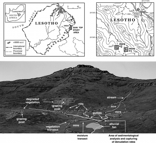
FIGURE 2. Gully denudation and aggradation for peat and mineral sediment surfaces (January 2000 to July 2001)
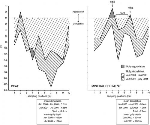
FIGURE 3. Otomys burrows and pathways within the peat horizon of a north-facing gully sidewall (gully depth ∼120 cm)
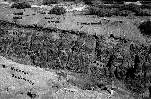
FIGURE 4. Cracked peat surfaces along gully sidewalls and adjacent areas. The cracks are infilled with sediment transported by wind and water (gully depth ∼3 m; width = 3–4 m)
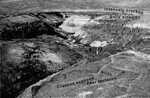
FIGURE 5. Particle size distribution for peat and mineral sediment and for a desiccation crack infill
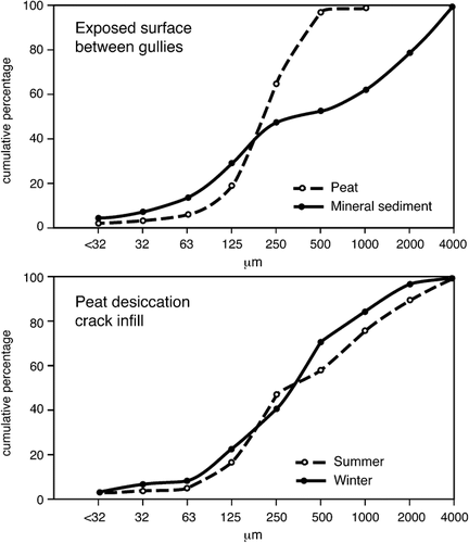
FIGURE 6. Ground thermal regime and associated horizontal particle movement for a north- and south-facing gully sidewall over 5 d in July 1999
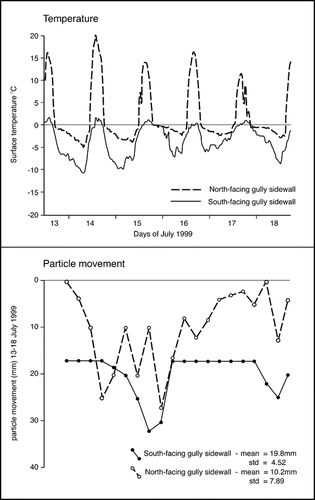
FIGURE 7. Soil moisture profiles across mire 1 during summer (Feb.) and winter (July) 2001
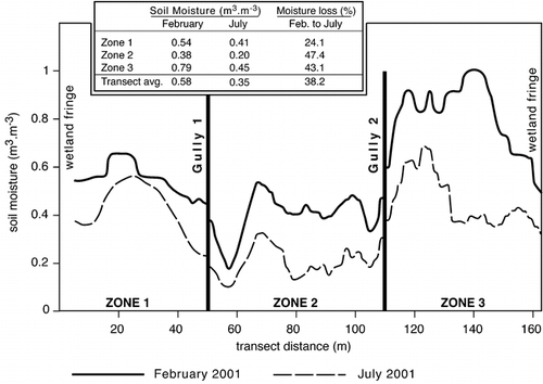
FIGURE 8. A biological transect across mire 1
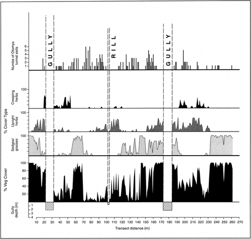
FIGURE 9. A vegetational transect across mire 2
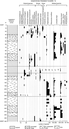
Table 1 Comparing shear strength values during February (summer) and July (winter) 1999 for various sedimentological settings (n = 30 per site). Percentage moisture and organics were measured in February
Acknowledgments
We appreciate the financial assistance provided by the Wits University Research Committee and the VW Foundation in Germany. The paper has been improved through constructive suggestions provided by Nel Caine and Lothar Schrott. Any errors remaining are solely those of the authors. We thank Wendy Job for reproducing the diagrams.
Related Research Data
References Cited
- Beckett, P. H T. and R. Webster . 1971. Soil variability: a review. Soils and Fertilizers 34:1–15.
- Burt, T. P. and D. P. Butcher . 1985. Topographic controls of soil moisture distributions. Journal of Soil Science 36:469–486.
- Calles, B. and L. Kulander . 1995. Storm rainfall characteristics at Roma, Lesotho. The South African Geographical Journal 77:6–11.
- Calles, B. and L. Kulander . 1996. Likelihood of erosive rains in Lesotho. Zeitschrift für Geomorphologie Suppl.-Bd. 106:149–168.
- Calles, B. and P. Stålnacke . 2000. Modelling soil moisture fluxes and surface runoff on event basis: an experimental study from Lesotho. Zeitschrift für Geomorphologie Suppl.-Bd. 122:17–31.
- Cammeraat, L. H. and A. C. Imeson . 1999. The evolution and significance of soil—vegetation patterns following land abandonment and fire in Spain. Catena 37:107–127.
- Campbell, I. A. and J. L. Honsaker . 1982. Variability in badlands erosion, problems of scale and threshold identification. In Thorn, C. E. (ed.), Space and Time in Geomorphology. London: Allen and Unwin, 59–79.
- Chakela, Q. K. 1981. Soil erosion and reservoir sedimentation in Lesotho. Ph.D. dissertation, UNGI Report No. 54, Uppsala University, Sweden. 152 pp.
- Collinson, A. 1996. Unsaturated strength and preferential flow as controls on gully head development. In Anderson, M. G., and Brooks, S. M. (eds.), Advances in Hillslope Processes. Chichester: Wiley, 753–769.
- Crawley, M. J. , P. H. Harvey , and A. Purvis . 1996. Comparative ecology of the native and alien floras of the British Isles. Philosophical Transactions of the Royal Society of London 351:1251–1259.
- Cronk, Q. C B. and J. L. Fuller . 1995. Plant Invaders: The Threat to Natural Ecosystems. London: Chapman and Hall. 241 pp.
- Duncan, P. 1960. Sotho Law and Custom. London: Oxford University Press. XX pp.
- Fitzjohn, C. , J. L. Ternan , and A. G. Williams . 1998. Soil moisture variability in a semi-arid gully catchment: implications for runoff and erosion control. Catena 32:55–70.
- Grab, S. 1997a. Thermal regime for a thufa apex and its adjoining depression, Mashai Valley, Lesotho. Permafrost and Periglacial Processes 8:437–445.
- Grab, S. 1997b. An Evaluation of the Periglacial Morphology in the High Drakensberg and Associated Environmental Implications. Ph.D. thesis, University of Natal, Pietermaritzburg. 400pp.
- Grab, S. 1998. Periglacial research in Africa: past, present and future. Progress in Physical Geography 22:375–384.
- Grab, S. 2001. Needle ice observations from the high Drakensberg, Lesotho. Permafrost and Periglacial Processes 12:227–231.
- Grab, S. and C. Morris . 1999. Soil and water resource issues of the eastern alpine belt wetlands in Lesotho. In Hurni, H., and Ramamonjisoa, J. (eds.), African Mountain Development in a Changing World. Antananarivo: African Mountains Association, African Highlands Initiative, and United Nations University, 207–219.
- Grab, S. and M. Nüsser . 2001. Towards an integrated research approach for the Drakensberg and Lesotho mountain environments: a case study from the Sani plateau region. The South African Geographical Journal 83:64–68.
- Hawley, M. E. , T. J. Jackson , and R. H. McCuen . 1983. Surface soil moisture variation on small agricultural watersheds. Journal of Hydrology 62:179–200.
- Henderson-Sellers, A. 1996. Soil moisture: a critical focus for global change studies. Global and Planetary Change 13:3–9.
- Hughes, F. M R. 1997. Floodplain biogeomorphology. Progress in Physical Geography 21:501–529.
- Imeson, A. C. and F. J P. M. Kwaad . 1980. Gully types and gully prediction. Geografisch Tijdschrift 14:430–441.
- Killick, D. J B. 1963. An account of the plant ecology of the Cathedral Peak area of the Natal Drakensberg. Botanical Survey of South Africa Memoir, 34. 178 pp.
- Killick, D. J B. 1990. A Field Guide: The Flora of the Natal Drakensberg. Johannesburg: Jonathan Ball and Ad. Donker Publishers. 200 pp.
- Klug, J. R. , J. M. De Villiers , N. M. Tainton , and L. S. Matela . 1989. Final Report of the Terrain Analysis Project for the Drakensberg/Maluti Mountain Catchment Conservation Programme. Pietermaritzburg: Natal Parks Board.
- Marake, M. , C. Mokuku , M. Majoro , and N. Mokitimi . 1998. Global Change and Subsistence Rangelands in Southern Africa: Resource Variability, Access and Use in Relation to Rural Livelihoods and Welfare. INCO-DC Project No. ERBIC18CT970162, National University of Lesotho, Roma. 48pp.
- Marker, M. E. 1994. Sedimentary sequences at Sani Top, Lesotho highlands, southern Africa. The Holocene 4:406–412.
- Meiklejohn, K. I. 1992. Some aspects of valley asymmetry in the high Drakensberg. The South African Geographical Journal 74:49–53.
- Meiklejohn, K. I. 1994. Valley asymmetry on south-eastern Alexander Island, Antarctica, and valley forms in the high Drakensberg, southern Africa. The South African Geographical Journal 76:68–72.
- Morris, C. D. , S. Boleme , and N. M. Tainton . 1989. Report on investigations into the fire and grazing regimes and the conservation needs of the eastern alpine catchments of Lesotho. Drakensberg/Maluti Mountain Catchment Conservation Programme, Fire and Grazing Project, Pietermaritzburg, 204 pp.
- Morris, C. D. , N. M. Tainton , and S. Boleme . 1993. Classification of the eastern alpine vegetation of Lesotho. African Journal of Range and Forage Science 10:47–53.
- Neil, D. and B. Yu . 1999. A method of analyzing stream channel response to environmental change: gauge data for the Tully River. Australian Geographer 30:239–252.
- Oostwoud Wijdenes, D. J. and R. B. Bryan . 1994. Gully headcuts as sediment sources on the Njemps Flats and initial low-cost gully control measures. In Bryan, R. B. (ed.), Soil Erosion, Land Degradation and Social Transition. Advances in GeoEcology, 27: 205–229.
- Pooley, E. 1998. A Field Guide to Wild Flowers: KwaZulu-Natal and the Eastern Regions. Durban: Natal Flora Publications Trust.
- Quinlan, T. and C. D. Morris . 1994. Implications of changes to the transhumance system for conservation of the mountain catchments in eastern Lesotho. African Journal of Range and Forage Science 11:76–81.
- Rydgren, B. 1988. A geomorphological approach to soil erosion studies in Lesotho. Geografiska Annaler 70A:255–262.
- Schwabe, C. A. 1989. The assessment planning and management of wetlands in the Maluti/Drakensberg mountain catchments. Institute of Natural Resources Investigation Report, No. 38.
- Schwabe, C. A. 1995. Alpine mires of the eastern highlands of Lesotho. In Cowan, G. I. (ed.), Wetlands of South Africa. Pretoria: Department of Environmental Affairs and Tourism, 33–40.
- Schwabe, C. A. and C. R. Whyte . 1993. An Investigation into the Distribution of Wetlands and Grasslands and Their Carrying Capacities within the Mokhotlong District of Lesotho. Pietermaritzburg: Department of Foreign Affairs, c/o Natal Parks Board. XX pp.
- Sene, K. J. , D. A. Jones , J. R. Meigh , and F. A K. Farquharson . 1998. Rainfall and flow variations in the Lesotho highlands. International Journal of Climatology 18:329–345.
- Showers, K. B. 1989. Soil erosion in the Kingdom of Lesotho: origins and colonial response, 1830s–1950s. Journal of Southern African Studies 15:263–286.
- Tickner, D. P. , P. G. Angold , A. M. Gurnell , and J. O. Mountford . 2001. Riparian plant invasions: hydrogeomorphological control and ecological impacts. Progress in Physical Geography 25:22–52.
- Turner, S. 1996. Gully reclamation in the lowlands and foothills of Lesotho: the Matelile Rural Development Project and the Mafeteng Development Project. In Critchley, W., and Turner, S. (eds.), Successful Natural Resource Management in Southern Africa. Namibia: Gamsberg Macmillan Publishers, 53–70.
- Tyson, P. D. , R. A. Preston-Whyte , and R. E. Schulze . 1976. The climate of the Drakensberg. Natal Town and Regional Planning Commission, 31, Pietermaritzburg.
- van Zinderen Bakker, E. M. 1955. A preliminary survey of the peat bogs of the alpine belt on northern Basutoland. Acta Geographica 14:413–422.
- van Zinderen Bakker, E. M. 1981. The high mountains of Lesotho—a botanical paradise. Veld and Flora 67:106–108.