Abstract
The value of glacier fluctuations as indicators of climate change detection has been increasingly recognized in recent years. Tropical glaciers are of particular interest. The Cordillera Blanca in Perú (77°30′W, 9°S) is the largest glaciated area within the tropics. Its 20th-century fluctuations have been analyzed. The total ice coverage around 1990 was obtained using optical satellite data SPOT XS. Based on the 1990 results, inventories and estimates of the glaciation during the 20th century had to be corrected. The data in this paper illustrate the general ice retreat in the tropical Cordillera Blanca: 620 km2 in 1990, 660–680 km2 in 1970, and 800–850 km2 in 1930. The 1930 value documents the extent of glaciation shortly after an intense advance in the 1920s. The Little Ice Age extent is estimated as 850–900 km2. The ice recession during the 20th century was not constant but was concentrated in two periods. Strong ice retreat occurred in the 1930s and 1940s and intermediate retreat from the mid-1970s until the end of the century. The ice coverage at the end of the 20th century is considered to be slightly below 600 km2.
Introduction
The value of glaciers as indicators of climate change has been widely recognized and has been considered by the IPCC (CitationIPCC, 2001). The Terrestrial Observation Panel for Climate within the Global Climate Observing System (GCOS/GTOS) recommended the observation of glacier extent as a key element of climate change detection (CitationGCOS, 1995). Besides the detailed monitoring of a few glaciers worldwide, less precise regional data is useful to test and evaluate the detailed measurements in a particular time and space. The goal of monitoring glacier fluctuations on a global scale has led to the establishment of worldwide databases such as the World Glacier Inventory (WGI; CitationHaeberli et al., 1998b, www.geo.unizh.ch/wgms/) or the World Data Center A for Glaciology (WDC-A; CitationFetterer et al., 2002, nsidc.org/wdc/). Still, these databases lack information about half of the world's glaciers (CitationHaeberli et al., 1998a).
Contributions from glaciers in the low latitudes are of particular interest for several reasons. Low-latitude glaciers are highly sensitive components of the environment and seem to react more immediately to fluctuations in climate than glaciers in the mid- and high latitudes (CitationWagnon et al., 1999; CitationKaser and Osmaston, 2002; CitationFrancou et al., 2003). They are receding rapidly, and the recession has accelerated in the late 20th century. Finally, low-latitude glaciers are poorly represented in the glaciological databases.
The Cordillera Blanca in northern Perú is the most extensively glacierized area in the tropics and provides an excellent archive of paleoclimate and glacier history (CitationThompson et al., 1995; CitationKaser and Georges, 1999). Apart from the benefit for climate studies on a global scale, knowledge of the Cordillera Blanca glacier fluctuations is of interest on a regional scale. Concerns include the dry-humid seasonal cycle, regional water resources management, and reference data for tropical climate-glacier modeling.
The Cordillera Blanca is located in the Andes at 77°30′W 9°S and stretches about 180 km from north-northwest to south-southeast; it extends only 30 km longitudinally (). For 1970, CitationAmes et al. (1989) reported a glacier extent of 723 km2. The majority of the Cordillera Blanca glaciers are thin, strongly crevassed, slope-type ice bodies without pronounced glacier tongues. The few existing valley-type glaciers form heavily debris-covered glacier tongues (CitationKinzl, 1942). CitationAmes et al. (1989) classified 61 valley-type glaciers (8.5%) out of 722 total glaciers. Of the Cordillera Blanca ice extent, 71% (439 km2) drains to the Pacific Ocean (catchment Rio Santa), the rest (29%, or 179 km2) to the Atlantic Ocean (catchment Rio Maranõn).
The general character of the glacier fluctuations in the 20th century is well documented for major phases of advance or retreat (CitationAmes and Francou, 1995; CitationKaser, 1999). Still, the precise ice extent is not known for the respective stages. A comprehensive description of the current knowledge is given by CitationKaser and Osmaston (2002) and is summarized here. Scientific research in the region began in the 1930s (CitationKinzl, 1935). The retreat of the Cordillera Blanca glaciers from the Little Ice Age (LIA) maximum extent (CitationKinzl, 1935) began in the second half of the 19th century. The glacier retreat at the begining of the 20th century was mentioned by, e.g., CitationSievers (1914) and CitationBroggi (1943). The retreat turned into a sudden powerful readvance in the 1920s that reached almost the former LIA extent (CitationKinzl, 1949; CitationKaser and Osmaston, 2002). Two maps in scale 1:100,000 (CitationBorchers, 1935a; Deutscher CitationAlpenverein, 1945) surveyed by CitationKinzl (1942, Citation1949) give a rough shape of the glaciers shortly after this readvance. In the 1930s and 1940s the glaciers again retreated rapidly (CitationKinzl, 1949; CitationAmes and Francou, 1995; CitationKaser and Georges, 1997). The following two decades brought only minor ice recession (CitationKaser et al., 1996; Ames, personal communication). Aerial photographs from the years 1948–1950, 1962, and 1970 document this period (CitationKaser and Osmaston, 2002). The 1970 photographs gave the basis for a comprehensive Cordillera Blanca glacier inventory (CitationAmes et al., 1989). This is the only detailed analysis of ice extent until the present. During the first half of the 1970s the glaciers were in equilibrium, or even advancing slightly (CitationKaser et al., 1990) as a result of positive mass balances (CitationKaser, 2003). Since then, the glaciers have increasingly retreated, at least until the 1997–1998 El Niño event. CitationMorales Arnao (2000) estimated the Cordillera Blanca ice coverage in 1997 at 611 km2 on the basis of satellite data.
After the 1997–1998 El Niño, prevailing La Niña conditions led to low temperatures and weak dry seasons, which resulted in continously snow-covered glacier tongues and at some glaciers slight advances (1999–2002 field observations of the Tropical Glaciology Group, Innsbruck). Reconstructed ice extents of single glaciers (CitationHastenrath and Ames, 1995a, Citation1995b; CitationAmes and Hastenrath, 1996) and in two mountain groups (CitationKaser et al., 1996; CitationKaser and Georges, 1997) for different periods of the 20th century support the fluctuation scheme described above. CitationAmes (1998) documented the rapid development of proglacial moraine-dammed lakes, which is connected with phases of ice retreat. These proglacial lakes are monitored continuously (CitationMorales et al., 1979) for potential outbreaks due to failures of the ice-containing moraines (CitationKinzl, 1940; CitationLliboutry et al., 1977a, Citation1977b). The lake monitoring has also produced time series for the recession of some glaciers (CitationAmes, 1998).
In this paper, I present a new calculation of the actual ice extent of the Cordillera Blanca. Its derivation from optical satellite data is discussed for reliability and uncertainties. Using this new ice extent figure and previous detailed analysis of ice recession in the Huascarán group (CitationKaser et al., 1996) and the Santa Cruz group (CitationKaser and Georges, 1997) (), the 1930s maps (CitationBorchers, 1935a; Deutscher CitationAlpenverein, 1945) and the 1970 glacier inventory (CitationAmes et al., 1989) are critically reviewed in order to (re)quantify the areal changes during the 20th century for the stages 1990, 1970, and 1930.
Glaciation About 1990
I used two SPOT (Système Probatoire d'Observation de la Terre) XS satellite scenes to extract the recent ice extent of the Cordillera Blanca. The scenes—the southern one taken in 1987, the northern in 1991 ()—cover about 90% of the Cordillera Blanca glaciers. Optical satellite data, predominantly LANDSAT and SPOT, have often been successfully applied for the delineation of glaciers (CitationDowdeswell and Williams, 1997; for a comprehensive overview, see, e.g., CitationKönig et al., 2001). The XS sensor of the SPOT platform provides three spectral bands (green, 0.50–0.59 μm; red, 0.61–0.68 μm; near infrared, 0.79–0.89 μm) at a nominal nadir pixel size of 20 × 20 m. No newer optical satellite scenes with sufficient spatial resolution and free from clouds and fresh snow existed in 1998, when the mapping was carried out. Landsat TM satellite data as used by CitationMorales Arnao (2000) had been excluded due to minor resolution. The resulting glacier mask can be regarded as “ca. 1990” (). The delination of the glaciers has already been used for the map “Cordillera Blanca, Nord (Perú),” scale 1:100,000, by the Austrian Alpine Club (CitationOesterreichischer Alpenverein, 2000; CitationMoser et al., 2000).
Both raw scenes were rectified using a high-resolution Digital Elevation Model (DEM) and geocoded to UTM zone 18. The DEM is based on 50-m contour lines and trigonometric points taken from 3 map sheets of the Carta Nacional del Perú, scale 1:100,000 (CitationInstituto Geografico Nacional, 1986). The contour lines originate from mapsheets in scale 1:25,000 (CitationDirección Generál de Reforma Agraria y Asentamiento Rurál, 1972), actually providing higher precision than can be expected for scale 1:100,000. The DEM was computed with the SURFER software (CitationGolden Software, 1997) using Kriging algorithm with default settings to 20-m pixel size. The rectification was carried out using the PCI Satellite Orthorectification package (CitationPCI, 1997). The Satellite Orthorectification package considers not only ground control points (GCPs) but also the platform's orbit and attitude in space. Thus, rectification results are generally better than those obtained using the usual applied methods. This quality was especially essential for the northern scene. While the southern scene is a nadir view, the northern one is an oblique image with a tilt angle of 14°. Due to the tilting, the northern scene evinces additional geometric bias, which complicated the identification of reliable GCPs. Consequently, the average residual root mean square (RMS) error of the GCPs used for the orthorectification of the southern scene is 20.2 m, whereas the respective value of the northern scene is 29.5 m. Visual comparisons of contour lines, the DEM, and the geocoded SPOT data confirmed the reliable rectification result. The rectified scenes were mosaiced along the Quebrada Honda (Honda valley; and ). Detailed information on the DEM generation and preprocessing of the satellite data is given in CitationGeorges (1998).
The ice extents were then interpreted visually to ensure high precision and subsequently digitized to a Geographic Information System (GIS) database. Attempts with automated classification algorithms were unsatisfactory due to the small number of available spectral channels (CitationGeorges, 1998). Most slope-type glaciers in the Cordillera Blanca reside on moderately steep slopes of polished granodiorite. Those glaciers have little or no debris. Thus, the ice edge could be easily delineated due to the contrast of the ice and the granodiorite. Nevertheless, there are limitations and uncertainties in the obtained areas for the following reasons.
Coverage of the satellite data: The very northwestern and southern edges of the Cordillera Blanca are missing in the satellite scenes (compare and ). These parts (mountain groups Champara, Pilanco, and western Santa Cruz in the north, Pongos and Caullaraju in the south) were added using the 1970 values given by CitationAmes et al. (1989). The 1970 values have been corrected to 1990 by the factor of recession from 1970 to 1990 in the Huascarán massif (CitationKaser et al., 1996), which is 51.4 km2/58.4 km2 = 0.88.
Resolution of the satellite data: The spatial precision of the interpretation is limited mainly by the pixel size of the SPOT XS sensor, since the geocoding attributes only small additional uncertainties. Because spatial elements or patterns must extend a few pixels for recognition, the spatial precision of the interpretation is 2–4 pixels for most parts. In the case of clearly visible ice edges, the precision of the delineation is in pixel resolution.
Clouds: A few clouds existed on the northern edge of the Contrahierbas glaciers ( and ), so the glacier limit for that area was estimated. Nevertheless, the error is small because the clouds were not extensive. All other ice-covered areas were free of clouds.
Bergschrunds: Bergschrunds separate the dynamically active glaciers from ice-covered steep slopes, which are dynamically inactive. Due to the resolution of the satellite data, those bergschrunds are usually difficult to recognize. The delineation of the active glaciers was done by comparing features in the satellite data and the contour lines (slope).
Debris coverage: This is the most prominent source of uncertainty in the interpretation and delineation of the glacier coverage. The few valley-type glaciers in the Cordillera Blanca are heavily debris covered, at least on their lower portions. Due to the extensive debris cover, it is difficult to distinguish whether (1) there is still ice in the body, and (2) this ice is still active. Those parts were delineated by the shape (concave or convex) of the surface. Only clearly concave surfaces, which document moving ice, were attributed to glaciers. This problem may result in a small underestimation of some glaciers.
The uncertainties were minimized by comparisons with many recent terrestrial photographs taken during the mapping by Alpenverein cartographers (CitationOesterreichischer Alpenverein, 2000) in 1995.
The sum of the ice-covered area in the Cordillera Blanca around 1990 was 619 km2 according to analysis of the SPOT scenes. lists the surface ice value in the Cordillera Blanca mountain groups from north to south. The Pilanco glaciers are usually attributed to Santa Cruz but have been treated separately for better comparability with CitationKaser and Georges (1997). Since the aforementioned problems affect only small areas and could be partly solved, the error can be estimated as less than 3%.
Ice Extent in 1970
The only exhaustive glacier mapping of the Cordillera Blanca available so far was carried out by CitationAmes et al. (1989) as part of the Glacier Inventory of Perú. CitationAmes et al. (1989) used the 1970 aerial photographs (for some missing parts, they used those from 1962) and obtained a total ice coverage of 723 km2 for 1970. (The sum obtained from individual tables for different catchments in CitationAmes et al. [1989] is 724 km2 [see ].)
The Huascarán group () was analyzed a second time by CitationKaser et al. (1996) from the same 1970 aerial photographs. This analysis provided an opportunity for an evaluation of the mapping by CitationAmes et al. (1989). Whereas CitationAmes et al. (1989) estimated the 1970 ice extent of the group at 61.5 km2, CitationKaser et al. (1996) found a total of 58.2 km2. The following reasons can be given for the difference of more than 5%:
The Glacier Inventory of Perú (CitationAmes et al., 1989) was prepared for all of Perú, with several cartographers mapping for some years. Thus, the perspective of that inventory is less detailed and precise than that of Kaser et al. (1989).
Ice-free areas within the glaciers were mapped very roughly and consequently may have been underestimated by CitationAmes et al. (1989).
The areal values were obtained by CitationAmes et al. (1989) using planimeters, which may overestimate small areas. CitationKaser et al. (1996) used a GIS for the areal analysis.
To obtain more accurate values for 1970, the original sketch maps by CitationAmes et al. (1989) were digitized to the existing GIS database of the Cordillera Blanca and joined with the “ice-free areas within the glaciers” layer from the “ca. 1990” satellite data. Although this is a 1990 layer, it pictures the ice-free areas more accurately than the 1970 sketch maps. The 1970–1990 change in ice-free areas within the glaciers was small, which could be confirmed by visual comparisons of the 1970 aerial photographs and the satellite data.
Differences of the glacier boundaries given by CitationAmes et al. (1989) and CitationKaser et al. (1996) mainly exist on the tongues of the valley-type glaciers. Again, the thick debris cover leads to uncertainties in the interpretation. Whereas CitationAmes et al. (1989) generally counted inactive ice bodies as part of the glaciers, CitationKaser et al. (1996) figured the glaciers to end where a visible bulge delimited the active from the inactive ice. Furthermore, deviations are found on some glaciers that end on the granodioritic slopes. Here, the glacier forefields are usually polished, so, depending on the illumination angle, these granodiorites may appear very bright in the aerial photographs. In some cases these areas were considered to be ice by CitationAmes et al. (1989).
Due to the given reasons, the Huascarán extent provided by CitationKaser et al. (1996) is regarded as more precise. Thus, the values obtained from the digitized 1970 sketch maps were scaled by 0.95 (i.e., ice extent Huascarán: CitationKaser et al. (1996)/CitationAmes et al. (1989) = 58.2km2/61.5km2), assuming a general overestimation by CitationAmes et al. (1989). shows the 1970 extents given in the Glacier Inventory of Perú (CitationAmes et al., 1989) and reevaluated as described above. Due to the strict delineation of uncertain tongues, the reevaluated values in have to be taken as lower boundary for the 1970 ice extent. Thus, the total ice coverage of 1970 in the Cordillera Blanca was 660 km2 minimum and most likely between 660 and 680 km2.
Glacier Extent in the 1930s
The maps “Cordillera Blanca” and “Cordillera Blanca—Südteil” (CitationBorchers, 1935a; Deutscher CitationAlpenverein, 1945, respectively) in scale 1:100,000 served for an approximation of the glacier extent in the 1930s. The northern part was surveyed in 1932 by CitationBorchers (1935b) and CitationKinzl (1942); the southern part is the result of a 1939 expedition by CitationKinzl (1949). Both maps were produced using terrestial photogrammetry techniques. The ice extents shown in the maps are close to the extent of the 1920s advance, since the most advanced position of the glacier tongues lasted until the end of the 1920s (CitationKinzl, 1942).
The ice limits were digitized to the GIS database, but the resulting areal values have to be taken as rough estimates for the following reasons:
Although the expeditions surveyed most of the Cordillera Blanca valleys, some were not visited. The shape of these areas (glaciers, contour lines, terrain) was entirely guessed.
Comparisons of the shape of the contour lines to the actual “Carta del Perú” reveal differences even in surveyed areas.
The shape of the glaciers is very smooth and seems to be strongly generalized. Furthermore, ice-free areas within the glaciers have been underestimated, as confirmed by comparisons of the maps and the original glass plates used for the production of the maps (the glass plates are part of the Kinzl photo archive at the Department of Geography, University of Innsbruck).
It was not possible to geocode the maps to UTM zone 18 (like the other GIS data sets) since the maps are projected to a local photogrammetric net with unknown parameters. An approach using GCPs failed.
The areal analysis was carried out by obtaining values from the digitized sources in the local net coordinates and then subtracting “ice-free” values taken from the “ice-free areas within the glaciers (1990)” layer for the respective mountain groups. Although very rough, this procedure still seemed more reliable than ignoring ice-free areas.
lists the results for the glacier area in the 1930s. The maximum ice extents during the 1920s advance were also derived for the Huascarán (CitationKaser et al., 1996) and Santa Cruz groups (without Pilanco) (CitationGeorges, 1996; CitationKaser and Georges, 1997) from the 1950 aerial photographs, where the 1920s moraines appear fresh and pronounced. Comparison of the respective values () reveals huge deviations for these groups between the maps and the aerial image analyses. Accounting for similar deviations in other groups and because of the rough data processing, the ice extent during the advance can be given only in the range of 800–900 km2.
Discussion
Quantitative information on the recent glacier extent of the Cordillera Blanca was missing or doubtful. The detailed analysis of the glacier coverage “ca. 1990” presented here closes this gap. The glaciers were receding strongly around 1990. Therefore, the extent has to be regarded as a snapshot in a dynamic situation. Thus, the time gap of 4 yr may result in notable changes between the derived extents in the northern part (1987 scene) and the southern part (1991 scene). The fact could be confirmed by comparisons of the satellite scenes and the aforementioned terrestrial photographs and surveys (CitationOesterreichischer Alpenverein, 2000) taken in 1995. Especially on the valley-type glaciers, rapidly changing inactive ice surfaces and active or inactive ice thresholds could be identified (CitationAmes, 1998). For example, the moraine-dammed Laguna Arhueycocha (Santa Cruz group) had developed to 600-m length in 1995, whereas there are only a few small ponds in the 1987 satellite scene (). This comparison documents the intensified ice loss in the first half of the 1990s.
According to the “ca. 1990” extent, reports of the Alpenverein cartographers (CitationOesterreichischer Alpenverein, 2000), and repeated fieldwork in the 1990s by the Tropical Glaciology Group, Innsbruck (CitationGeorges and Kaser, 2002), the period of strong ice retreat lasted at least until the 1997–1998 El Niño event. Thus, a total ice coverage of slightly below 600 km2 can be assumed for the end of the century, whereas the 1997 value of 611 km2 given by CitationMorales Arnao (2000) must be considered slightly overestimated. Furthermore, CitationMorales Arnao (2000) provided no information about how the 1997 extent was derived. As a consequence of the prevailing strong La Niña conditions after the 1997–1998 El Niño episode (CitationWang and McPhaden, 2001), some glaciers stopped retreating or have even slightly advanced since 1998 (unpublished measurements and observations during fieldwork, 1999–2002, by members of the Tropical Glaciology Group, Innsbruck). In general, the impact of the El Niño Southern Oscillation in the Cordillera Blanca region seems to be restricted to temperature fluctuations (CitationFrancou et al., 1995), whereas influence on precipitation amounts is small in this part of the Andes (CitationAceituno, 1988). Still, slightly weakened dry seasons as observed after 1997 had a marked impact on the glaciers' mass balance (CitationWagnon et al., 1999).
It has already been shown that the ice coverage in 1970 was overestimated by CitationAmes et al. (1989) by up to 10% (). Following the corrected 1970 values presented here, the total surface ice extent in 1970 was about 6% larger than “ca. 1990.” In only those groups are shown that are covered by the SPOT scenes. The northern mountain groups have notably higher relative values than the southern ones, except Santa Cruz. However, further comparisons with CitationKaser et al. (1996), CitationGeorges (1996), CitationKaser and Georges (1997), and 1970 aerial photographs led to the impression that the reason for these values was more a nonhomogeneous quality of the photo interpretation by CitationAmes et al. (1989) than a clear spatial pattern in ice retreat. Accordingly, the values for 1970 given in and should be used with care. Nevertheless, the general ice retreat is remarkable, even more so because an areal loss of 6% happened within 15 yr, since the Cordillera Blanca glaciers were in steady state or slightly advancing until 1975 (CitationKaser et al., 1990; CitationHastenrath and Ames, 1995a). Furthermore, the ice shrinkage lasted for nearly 1 decade more and intensified in the 1990s.
lists the ice extents in the detailed analyzed mountain groups (CitationKaser et al., 1996; CitationKaser and Georges, 1997) compared to the “ca. 1990” extent. According to the table, the corrected 1970 values approximate the ice extent for the preceeding 2 decades. Therefore, the ice extent at the end of the 1930s–1940s retreat phase must have been below 110% of the “ca. 1990” extent.
The 1930s maps were surveyed shortly after the 1920s readvance and give an estimate of the advanced glacier extents. Since the readvance nearly reached the LIA moraines (CitationKinzl, 1949; CitationKaser and Osmaston, 2002) they may also be considered an approximation of the LIA extent. The percentage for the mountain groups in the 1930s compared to the 1990 SPOT extent deviates from 117 to 165% (). A general advanced position of all Cordillera Blanca glaciers in the 1920s was reported but seems to have been more uniformly distributed (CitationKinzl, 1942, Citation1949). The higher values of the northern groups are an artifact of the maps. The northern map was produced first and is much more generalized, whereas the southern map is detailed with features such as rock islands and moraines. Regarding the southern map as more precise, the ice extent after the 1920s readvance was about 130% of “ca. 1990,” or 800–850 km2 .
Still, the 1930s–1940s shrinkage of the glaciers was very strong: about 20% of the “ca. 1990” extent, or more than 100 km2 areal loss within 20 yr. Thus, the intensity of the 1930s–1940s retreat was more pronounced than that of the one at the end of the century. Even reflecting the increasing recession during the 1990s, the retreat phase at the end of the 20th century surely did not result in an areal loss of 100 km2.
The LIA extent must have been slightly higher than the 1920s readvance (850–900 km2) (CitationKaser and Osmaston, 2002). The minimum extent between the LIA and the 1920s readvance cannot be obtained from the sources used in this investigation. It must have been clearly below the extent shown on the maps, since the readvance was marked.
is an updated graph already presented by CitationKaser and Osmaston (2002). The knowledge of the 20th-century glacier fluctuations in the Cordillera Blanca is adapted to the new and (re)evaluated ice extents in . The ice loss during the 20th century affected the glacier types in the Cordillera Blanca in different ways. Small-scale and low-lying glaciers vanished. Slope-type glaciers receded mainly by a rise of the lower boundary, parallel to the contours. Accordingly, their shape did not change much. The valley-type glaciers usually lost most of their tongues and thus changed shape. Nowadays, only inactive ice—buried by a huge debris cover—is left of the former glacier tongues. The shape of the former valley-type glaciers more and more approaches the shape of the slope-type glaciers. As a result, the ice cover of the Cordillera Blanca is more exposed to direct radiation today than it was earlier in the last century.
Conclusions
Combining good qualitative knowledge and new quantative results, a consistent figure for the 20th-century Cordillera Blanca glacier fluctuations could be obtained. Data are based on detailed analysis of “ca. 1990” satellite data and (re)evaluations of former interpretations of aerial image and maps. According to the results, the Cordillera Blanca's ice coverage was 620 km2 around 1990, 660–680 km2 in 1970, 800–850 km2 in 1930, and 850–900 km2 at the end of the LIA maximum. The ice recession during the past century was not uniformly distributed in a temporal view but was strong in the 1930s and 1940s and intermediate from the mid-1970s until the end of the century. Between these two periods, the recession was small. The beginning of the century was characterized by a glacier recession of unknown extent, followed by a marked readvance in the 1920s that nearly reached the Little Ice Age maximum.
The glacier fluctuations at the end of the 20th century show some very interesting features, which should be monitored continously by means of remote sensing and local surveys. Recent optical satellite data, such as ASTER or Landsat ETM+, can help delineate the actual ice extent of the complete Cordillera Blanca to determine the recession since 1990. They are planned within the GLIMS (Global Land Ice Measurements from Space) initiative. High-resolution field surveys can document ongoing small-scale fluctuations at the turn of the millenium.
The 1990 and 1970 ice extents, as well as the high-resolution Digital Elevation Model covering the complete Cordillera Blanca, are managed in a homogenous GIS database, which enables the use of a wide range of further analyses on different scales. A first application has been published by CitationKaser et al. (2003).
FIGURE 1. The Cordillera Blanca in northern Perú. Gray shadings refer to ice extent in 1970 with names of the 12 mountain groups. Quebrada Honda (in italics) divides the northern and southern part. The dashed line documents the coverage of the SPOT satellite scenes. The inlay shows the Cordillera's position in South America
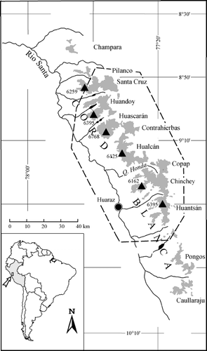
FIGURE 2. The rectified SPOT scenes showing the Cordillera Blanca “ca. 1990.” The boundary between the northern scene (646–368, 22 July 1991) and the southern scene (646–369, 2 June 1987) is shown by the red line. Channel combination: red, XS1; green (3 * XS1 + XS3)/4; blue: XS3
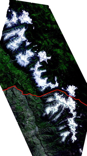
FIGURE 3. Fast development of Laguna Arhueycocha (Cordillera Blanca, Perú): only small ponds exist in 1987 (arrows in SPOT scene, above), whereas the lake fills the whole end moraine in 1995 (Alpenverein map “Cordillera Blanca Nordteil,” scale 1:100,000, below, based on 1995 surveying)
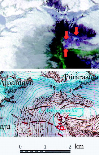
FIGURE 4. Sketch of the glacier fluctuations in the Cordillera Blanca since the end of the Little Ice Age (LIA) maximum according to the presented “ca. 1990” extent, the corrected 1970 value, and the estimation of the 1920s readvance (modified from CitationKaser and Osmaston [2002])
![FIGURE 4. Sketch of the glacier fluctuations in the Cordillera Blanca since the end of the Little Ice Age (LIA) maximum according to the presented “ca. 1990” extent, the corrected 1970 value, and the estimation of the 1920s readvance (modified from CitationKaser and Osmaston [2002])](/cms/asset/01b0066d-b979-4579-aa1a-6d28eea75ce2/uaar_a_11956975_f0010.gif)
Table 1 Covered area, date of scanning, and path/row of the SPOT XS scenes used in this study
Table 2 Glaciated area of the mountain groups in the Cordillera Blanca around 1990. The mountain groups are arranged from north to south. Italics refer to corrected values from Ames et al. (1989). For locations, compare with Figure 1
Table 3 Glaciated area in km2 of the mountain groups in the Cordillera Blanca in 1970 as given in the Glacier Inventory of Perú by Ames et al. (1989) and reevaluated as described in the text. The mountain groups are arranged from north to south
Table 4 Estimates of ice coverage of the Cordillera Blanca mountain groups in the 1930s taken from maps by Borchers (1935a) and Deutscher Alpenverein (1945). Values obtained by aerial photograph analysis refer to Kaser et al. (1996), Georges (1996), and Kaser and Georges (1997). The mountain groups are arranged from north to south
Table 5 Ice extent in the Cordillera Blanca in 1970 and the 1930s compared to the ca. 1990 situation in %. The mountain groups are arranged from north to south
Table 6 Surface ice area in 1930, 1950, 1970, and 1990 in the mountain groups Huascarán and Santa Cruz as given by different authors (values for 1990 refer to this paper)
Acknowledgments
The study was supported by the Fonds zur Förderung der wissenschaftlichen Forschung in Österreich (Austrian Science Foundation) under contract P-13567. The SPOT analysis was carried out in cooperation with the Österreichischer Alpenverein (Austrian Alpine Club). The Alpenverein cartographers Gerhard Moser and Herbert Schirmer kindly provided many terrestrial photographs. Fieldwork was supported by Ing. Marco Zapata (INRENA, Huaraz, Perú). I would like to thank Georg Kaser for helpful comments and discussions. Referees Todd Albert and Pierre Ribstein are gratefully acknowledged. Their recommendations helped to improve the paper.
Related Research Data
References Cited
- Aceituno, P. 1988. On the functioning of the southern oscillation in the South American sector, Part I: Surface climate. Monthly Weather Review 116:505–524.
- Ames, A. 1998. A documentation of glacier tongue variations and lake development in the Cordillera Blanca, Peru. Zeitschrift für Gletscherkunde und Glazialgeologie 34:1 1–36.
- Ames, A. and B. Francou . 1995. Cordillera Blanca glaciares en la historia. Bulletin de l'Institut Francais d'Etudes Andines 24:1 37–64.
- Ames, A. and S. Hastenrath . 1996. Mass balance and ice flow of the Uruashraju glacier, Cordillera Blanca, Peru. Zeitschrift für Gletscherkunde und Glazialgeologie 32:83–89.
- Ames, A. , G. Muñoz , J. Verastegui , R. Vigil , M. Zamora , and M. Zapata . 1989. Glacier Inventory of Perú, Vol. 1. Hidrandina S. A. Unidad de Glaciologia e Hidrologia.
- Borchers, P. 1935a. Cordillera Blanca. Topographical map, scale 1:100,000. Published with support of the Deutscher und Österreichischer Alpenverein.
- Borchers, P. 1935b. Die weiße Kordillere. Berlin: Scherl. 396 pp.
- Broggi, J. A. 1943. La desglaciación actual de los Andes del Perú. Boletin de la ociedad Geológica del Perú 14/15:59–90.
- Alpenverein, Deutscher 1945. Cordillera Blanca Südteil. Topographical map, scale 1:100,000.
- Dirección Generál de Reforma Agraria y Asentamiento Rurál, 1972. Catastro rural. Contour-line map, scale 1:25,000.
- Dowdeswell, J. and M. Williams . 1997. Surge-type glaciers in the Russian high arctic identified from digital satellite imagery. Journal of Glaciology 43:145 489–494.
- Fetterer, F. , L. Cheshire , D. Kohlerschmidt , L. Schmidt , J. Wolfe , and L. Yohe . 2002. Annual report 2001: 25 years of snow and ice data and research. Technical report, National Snow and Ice Data Center. World Data Center for Glaciology, Boulder, CO.
- Francou, B. , P. Ribstein , H. Semiond , C. Portocarrero , and A. Rodriguez . 1995. Balances de glaciares y clima en Bolivia y Peru: impacto de los eventos ENSO. Bulletin de l'Institut Francais d'Etudes Andines 24:3 661–670.
- Francou, B. , M. Vuille , P. Wagnon , J. Mendoza , and J-E. Sicart . 2003. Tropical climate change recorded by a glacier in the central Andes during the last decades of the 20th century: Chacaltaya, Bolivia, 16°S. Journal of Geophysical Research 108:D5 4145–4155.
- GCOS, 1995. GCOS/GTOS panel for terrestrial climate-related observations, Version 1.0. GCOS-21, WMO/TD–no. 721, WMO.
- Georges, C. 1996. Untersuchungen zu den rezenten Gletscherschwankungen in der nördlichen Cordillera Blanca, Perú. Thesis, Department of Geography, University of Innsbruck. 135 pp.
- Georges, C. 1998. Bestimmung der aktuellen Vergletscherung der nördlichen Cordillera Blanca, Peru, mit Hilfe von Satellitendaten. Technical report, Department of Geography, University of Innsbruck.
- Georges, C. and G. Kaser . 2002. Ventilated and unventilated air temperature measurements for glacier-climate studies on a tropical high mountain site. Journal of Geophysical Research 107:D24 4775.
- Golden Software, 1997. Surfer 7 user's guide: contouring and mapping for engineers and scientists. Golden Software.
- Haeberli, W. , M. Hoelzle , and S. Suter . (eds.),. 1998a. Into the second century of worldwide glacier monitoring: prospects and strategies. A contribution to the International Hydrological Programme (IHP) and the Global Environment Monitoring System (GEMS). Number 56 in Studies and Reports in Hydrology. UNESCO.
- Haeberli, W. , M. Hoelzle , S. Suter , and R. Frauenfelder . (eds.),. 1998b. Fluctuations of Glaciers 1990–95, Volume 7. World Glacier Monitoring Service, IAHS (ICSI)–UNEP–UNESCO.
- Hastenrath, S. and A. Ames . 1995a. Diagnosing the imbalance of Yanamarey glacier in the Cordillera Blanca of Peru. Journal of Geophysical Research 100:D3 5105–5112.
- Hastenrath, S. and A. Ames . 1995b. Recession of Yanamarey glacier in Cordillera Blanca, Peru, during the 20th century. Journal of Glaciology 41:137 191–196.
- Instituto Geografico Nacional, 1986. Carta Nacional del Perú. Topographical map, scale 1:100,000.
- IPCC (ed.),. 2001. Climate Change 2001: The Scientific Basis. Contribution of Working Group I to the Third Assessment Report of the Intergovernmental Panel on Climate Change. Cambridge: Cambridge University Press. 881 pp.
- Kaser, G. 1999. A review of the modern fluctuations of tropical glaciers. Global and Planetary Change 22:93–103.
- Kaser, G. and C. Georges . 1997. Changes of the equilibrium line altitude in the tropical Cordillera Blanca (Perú) between 1930 and 1950 and their spatial variations. Annals of Glaciology 24:344–349.
- Kaser, G. and C. Georges . 1999. On the mass balance of low latitude glaciers with particular consideration of the Peruvian Cordillera Blanca. Geografiska Annaler 81:643–651.
- Kaser, G. and H. Osmaston . 2002. Tropical Glaciers. Cambridge, New York, Madrid: UNESCO, Cambridge University Press. 228 pp.
- Kaser, G. , A. Ames , and M. Zapata . 1990. Glacier fluctuations and climate in the Cordillera Blanca, Perú. Annals of Glaciology 14:136–140.
- Kaser, G. , C. Georges , and A. Ames . 1996. Modern glacier fluctuations in the Huascarán-Chopicalqui massif of the Cordillera Blanca, Perú. Zeitschrift für Gletscherkunde und Glazialgeologie 32:91–99.
- Kaser, G. , I. Juen , C. Georges , J. Gomez , and W. Tamayo . 2003. The impact of glaciers on the runoff and the reconstruction of mass balance history from hydrological data in the tropical Cordillera Blanca, Perú. Journal of Hydrology 282:1–4 130–144.
- Kinzl, H. 1935. Gegenwärtige und eiszeitliche Vergletscherung in der Cordillera Blanca (Peru). Verhandlungen des Deutschen Geographentages. Bad Nauheim: Deutscher Geographentag, 41–56.
- Kinzl, H. 1940. La ruptura del lago glacial en la Quebrada Ulta en el anño 1938. Boletin del Museo de Historia Natural “Javier Prado,” (4): 153–167.
- Kinzl, H. 1942. Gletscherkundliche Begleitworte zur Karte der Cordillera Blanca (Peru). Zeitschrift für Gletscherkunde 28:1–19.
- Kinzl, H. 1949. Die Vergletscherung der Südhälfte der Cordillera Blanca (Peru). Zeitschrift für Gletscherkunde und Glazialgeologie 1:1–28.
- König, M. , J-G. Winther , and E. Isaksson . 2001. Measuring snow and glacier ice properties from satellite. Reviews of Geophysics 39:1–27.
- Lliboutry, L. , B. Morales , and B. Schneider . 1977a. Glaciological problems set by the control of dangerous lakes in Cordillera Blanca, Perú. Part III. Study of moraines and mass balances at Safuna. Journal of Glaciology 18:79 275–290.
- Lliboutry, L. , B. Morales Arnao , A. Pautre , and B. Schneider . 1977b. Glaciological problems set by the control of dangerous lakes in Cordillera Blanca, Perú. Part I. Historical failures of morainic dams, their causes and prevention. Journal of Glaciology 18:79 239–254.
- Morales, B. , M. Zamora , and A. Ames . 1979. Inventario de lagunas y glaciares del Peru. Boletin de la Sociedad Geológica del Perú 62:63–82.
- Morales Arnao, B. 2000. Los eternos nevados en el Peru estan retrocediendo en forma cada vez mas acelerada. El medio ambiente en el Peru. Lima: Instituto Cuanto, 17–24.
- Moser, G. , C. Georges , and H. Schirmer . 2000. Die neue Karte der Cordillera Blanca, Nord. Berg 2001. Alpenvereinsjahrbuch 125. Innsbruck: Österreichischer Alpenverein, 48–53.
- Oesterreichischer Alpenverein, 2000. Alpenvereinskarte 0/3a, Cordillera Blanca Nord. Alpenvereinskartographie, topographical map, scale 1:100000.
- PCI, 1997. Using PCI Software, Version 6.2. 2 volumes. Richmond Hill, Ontario: PCI.
- Sievers, W. 1914. Reise in Peru und Equador, ausgeführt 1909, Vol. 8. Veröffentlichungen der Gesellschaft für Erdkunde zu Leipzig.
- Thompson, L. , E. Mosley-Thompson , M. Davis , P. Lin , K. Henderson , J. Cole-Dai , J. Bolzan , and K. Liu . 1995. Late glacial stage and Holocene tropical ice core records from Huascarán, Peru. Science 269:46–50.
- Wagnon, P. , P. Ribstein , G. Kaser , and P. Berton . 1999. Energy balance and runoff seasonality of a Bolivian glacier. Global and Planetary Change 22:49–58.
- Wang, W. and M. J. McPhaden . 2001. Surface layer temperature balance in the equatorial Pacific during the 1997–98 El Niño and 1998–99 La Niña. Journal of Climate 14:16 3393–3407.