Abstract
In eastern Canada, snow avalanches are a common phenomenon, but their occurrences remain poorly documented. In the last 30 yr, they were responsible for deaths and damage to property and forests in avalanche-prone areas in northern and eastern Québec. This study provides tree-ring–based avalanche chronologies for three scree slope stands in the northern Gaspé Peninsula (Québec). Tree-ring records indicated that high-magnitude avalanches occurred seven times during the period from 1860 to 1997, i.e., in 1871, 1898, 1952, 1956, 1966, 1977, and 1996, with 5- to 15-yr return intervals for the period between 1939 and 1997. High-magnitude avalanches occurred during snowy winters, with total snowfall well above average (330 cm). According to the size of past runout zones established from damaged trees at the main study stand, snow avalanches were greater in 1956 and 1966 than in 1996. The 1996 avalanche area was about 16,600 m2 of which 60% (10,000 m2) was covered with mature trees. It caused a ∼200-m recession of the tree line. Causal factors of snow avalanches including weather conditions and stand characteristics were also examined.
Introduction
Snow avalanche occurrences are poorly documented in eastern Canada as opposed to western Canada and United States, where historical as well as tree-ring records of avalanches are available (CitationShroder, 1978; CitationCarrara, 1979; CitationButler and Malanson, 1985a, Citation1985b; CitationVeblen et al., 1994; CitationRayback, 1998). The lack of information pertaining to avalanche activity is acknowledged by scientists, wilderness area and national park authorities, and land-use planners. Surveys in the interior high plateaus of the Gaspé Peninsula, eastern Québec (), indicate that snow avalanches are a risk for backcountry skiers (CitationGirard and Hétu, 1989; CitationHétu et al., 1994). In northern and eastern Québec, three avalanche events in the last 8 yr, i.e., in 1995 in Blanc-Sablon (St. Lawrence North Shore), 1999 in Kangiqsualujjuak (east of Ungava Bay) and 2000 at Mount Albert (Gaspésie National Park) have contributed to alert government and public security services to the risks of further damage to property (buildings, roads) and forests in avalanche-prone areas. These events all caused deaths and in some cases major impacts upon human installations, and thus contributed to increased attention to the causes and key variables influencing the movement of large snow masses along steep slopes.
Avalanches result from a combination of climatic factors and stand characteristics (CitationFitzharris and Schaerer, 1980; CitationFöhn, 1992; CitationWalsh et al., 1994; CitationKeylock, 1997; CitationSchneebeli et al., 1997; CitationBlikra and Selvik, 1998). However, an increase in anthropogenic triggers and damage to infrastructure were documented over the last decades, especially in alpine sites without avalanche control and protection structures, and in areas where no restrictions to erect infrastructures in hazardous areas were implemented (CitationLachapelle, 1977; CitationJamieson, 1997; CitationRayback, 1998).
In the northern Gaspé Peninsula (), the study of present-day processes on active scree slopes allowed the identification of a large variety of debris transfer processes, which included snow avalanches (CitationHétu and Gray, 2000). In the Mount St. Pierre Valley (), CitationHétu and Vandelac (1989) documented geomorphic processes during the cold season from direct field observations during ∼10 yr. They found that small avalanches are common and occur in the active scree zone, in autumn and spring mainly. Since the early 1980s, two large snow avalanches were documented for this valley; one during winter 1985–1986 which devastated 900 m2 of forests (CitationHétu and Vandelac, 1989; stand T-6) and one during winter 1995–1996 at stand T-5 (one of our three study stands) which also caused forest recession. We visited this avalanche track during summer 1996 and fieldworks were carried out during summer 1997. Since scree slope T-5 has been the focus of debris transfer process observations for the last ∼20 yr, the 1996 avalanche appears to have been a highly unusual event. Thus, we have hypothesized that other similar high-magnitude avalanches possibly occurred in the past at this stand and other scree slopes.
The objectives of this study were (1) to provide an estimate of frequency of high-magnitude avalanches at three stands showing evidence of multi-event tree damages, from two coastal valleys in the northern Gaspé Peninsula () and (2) to calculate return intervals of high-magnitude avalanches by using appropriate tree-ring techniques (CitationPotter, 1969; CitationShroder, 1978, Citation1980; CitationJohnson, 1987; CitationPatten and Knight, 1994; CitationLarocque et al., 2001). The coincidence between high-magnitude avalanche occurrences and snowfalls was evaluated and factors responsible for avalanche activity on scree slopes also were discussed.
Study Area
The two study valleys are surrounded by a plateau (∼ 400–600 m a.s.l.) composed of Cambro-Ordovician sedimentary folded rocks (thin-bedded shales, argillites, and siltstones) of the Cloridorme Formation (CitationEnos, 1969). The surface of the plateau is dissected by valleys which remained glaciated until the end of the Younger Dryas (ca. 10,700–10,400 yr BP). The Goldthwait seawaters invaded low lying coastal areas (<55 m) between 12,000 and 9000 yr BP, according to 14C dated marine shells (CitationHétu and Gray, 2000).
In the northern Gaspé Peninsula, the mean annual temperature is about 3.2°C (CitationEnvironment Canada, 1992), and annual precipitation totals about 825 mm, with 35% falling as snow between mid-November and late April. Data from Cap-Madeleine (1885–1994) and Grande-Vallée (1994–2000) weather stations indicate that total snowfalls averaged 330 cm. Prevailing winds (35% frequency) blow from the northwest (CitationGagnon, 1970). Patterns of snow accumulation vary largely depending on local topography and slope aspects (CitationHétu and Vandelac, 1989). Slopes on the east valley side are largely exposed to strong winds (>50 km h−1) and occasional gales (>100 km h−1) from the northwest across the St. Lawrence Estuary (). Steep cliffs above active scree slopes do not accumulate snow (CitationHétu and Vandelac, 1989; CitationHétu, 1992). Although exposed scree slopes can remain free of snow at the beginning of winter, they can accumulate large amounts of snow later in the winter, especially after major snow storms (CitationHétu and Vandelac, 1989).
Scree slopes developed in the Mount St. Pierre Valley throughout the postglacial period, and they are modified by a large variety of debris transfer processes (CitationHétu and Gray, 2000). Several scree slopes were stabilized by vegetation sometime during the Holocene, while others remained active in the uppermost parts. Tree-ring data from scree slopes T-5 and T-3, our two study stands of the Mount St. Pierre Valley, showed that the treeline was lower around 1850, expanded until the middle of the 20th century and then receded to its present position after 1950 (CitationHétu, 1990; CitationLafortune et al., 1997). White cedar (Thuya occidentalis L.) is the dominant tree species at the scree/forest interface where it is growing as shrubs <1 m in height. The third stand studied is located in the Rivière-à-Claude Valley (RC), 5 km from the seashore ().
Methods
STAND SELECTION
The three study stands are located on the east valleyside, i.e., west-facing slopes, where large scree slopes are still active, as opposed to those on the west valleyside which are largely forested. Stand selection was based primarily on slope aspects and evidence for past large avalanche events. The two documented high-magnitude avalanche events (1986–1987 and 1995–1996) which caused forest recession occurred both on east slopes of Mount St. Pierre Valley. Moreover, at two stands (T-3 and RC), shrubby vegetation patches at the edge of forests in the upper slopes were clearly visible on the 1963 aerial photographs. We thus hypothesized that vegetation rejuvenation was possibly associated with similar high-magnitude avalanche events.
STAND CHARACTERISTICS
At stand T-5, the rockwall above this 525-m long scree slope is about 140 m high (, ). From the bottom of the rockwall to the base of the slope, the difference in level is about 325 m. The upper 110 m of the scree slope is an active vegetation-free zone with steep slopes (34–40°), although a long (190 m) secondary scree tongue penetrated into the forest stand, i.e., 300 m from the rockwall. On both sides of the scree tongue, outside the 1996-avalanche track, white cedar, balsam fir (Abies balsamea (L.) Mill.), and paper birch (Betula papyrifera Marsh.) form mixed stands. In the lower slope, hardwood-balsam fir forests showed no tree damage associated with snow avalanche, but signs of logging were found locally.
Scree slope T-3 is 650 m long with a 60- to 70-m-high rockwall composed of friable thin-bedded shales (, ). The difference in level is about 375 m from the rockwall to the base of the slope. The active zone is steep (31–40°) and variable in length as several scree tongues penetrated into the forest, as far as 450 m from the rockwall. The vegetation surrounding scree slope T-3 is similar to that at scree slope T-5.
Scree slope RC is 600 m long and the difference in level between the rockwall and the base of the slope is 350 m. The ∼50-m-high rockwall was dissected by gullies. The steep (35–40°), vegetation-free zone is 240 m in length (, ). The forest fringe is composed of shrubby white cedar. The forest stand below the active zone is dominated by white cedar and balsam fir, whereas the lower slope is occupied by mixed hardwood-balsam fir-white cedar stands.
SAMPLING
Stand T-5
A slope long profile was levelled using a Brunton compass (accuracy: ± 1°). Here, the 1996 avalanche provided an opportunity to study the impact of a high-magnitude event on woody vegetation. A 240 m × 60 m grid was used for delineating the scree tongue and the treed surface devastated by the avalanche ().
All stems from dead and living trees were surveyed along three 1-m-wide and 50-, 55-, and 60-m-long transects, respectively, using the following categories: living trees: standing, tilted (>20° from the vertical), and lying on the ground surface; dead trees: broken and uprooted (). The lower transect (Tr-1), 280 m from the rockwall, was positioned at the forefront of the runout zone, and transect Tr-3, 180 m from the rockwall, in the upper avalanche track. Stem diameter was measured at the root collar. We assumed that most dead trees were killed during avalanches given the downslope stem orientation and the relatively young age of trees which established between 1900 and 1950–1960 in upper treed scree slopes (CitationHétu, 1990; CitationLafortune et al., 1997). Frost-coated clast flows may contribute to stem tilting and tree death, but this process causes partial burial of living tree trunks by clastic material (CitationHétu and Gray, 2000). No debris clasts were overlying the topsoil within the avalanche track.
At this stand, 62 trees were sampled for the reconstruction of past avalanches. Many trees showed evidence of multi-event tree damages, i.e., impact scars (injuries caused by bark scouring). A total of 112 cross sections was thus examined. Because impact scars and reaction wood (colored wood tissue produced when a tree is tilted) have provided the most reliable evidence of past movements (e.g., CitationBurrows and Burrows, 1976; CitationCarrara, 1979; CitationShroder, 1978, Citation1980; CitationPatten and Knight, 1994; CitationVeblen et al., 1994; CitationRayback, 1998; CitationLarocque et al., 2001), we used living trees with impact scars and tilted trees to develop stand-level avalanche chronologies.
At this stand, 25 out of the 62 trees sampled for avalanche dating produced new leaders (n = 38) from dormant axillary buds on the stem or from a branch, which shifted from a subhorizontal (plagiotropic) axis to a stem-like vertical (orthotropic) axis. This transformation marks a change in axis direction and induces radial growth release (CitationBégin and Filion, 1999). Dating of shoot initiation or radial growth release in branches transformed into stem-like structures was used to evaluate the time lag (number of years) for surviving trees to respond to stem damage, and thus to evaluate their accuracy and usefulness in dating past avalanche events (CitationCarrara, 1979).
Stands T-3 and RC
A slope long profile was leveled in each stand. In stand T-3, it was leveled south of the scree tongue investigated by CitationLafortune et al. (1997). Tilted trees (>20° from the vertical) and trees bearing impact scars were sampled down the slope along a 1-m-wide transect which paralleled the long profile at each stand. Transects were 665 m and 595 m long at stands T-3 and RC, respectively, where 20 and 28 trees were sampled for the reconstruction of past avalanches. Because several trees had multiple impact scars, a total of 24 and 34 cross sections was examined from stands T-3 and RC, respectively.
TREE-RING RECONSTRUCTION OF AVALANCHES
Finely-sanded, cross-sectional disks were analyzed under a binocular microscope. No annual rings were missing. Anomalies in growth rings (reaction wood lasting for at least 2 yr) and stems (impact scars) were surveyed and dated in each tree by ring counting along two or three radii. A drastic change in the direction of reaction wood was considered originating from a distinct avalanche event. The data were expressed in the form of event-response histograms (CitationShroder, 1978). For each year t, the index I was calculated based on the percentage of responses in relation to number of trees alive in year t:
where R represents the response to an event for year t and A the number of trees alive in year t. Each stand-scale chronology of high-magnitude avalanches was based on ≥10% threshold on the event-response histogram. Because of the overestimation created by a low number of trees in the calculation of percentage of responses, years with sample size ≥10 individuals were considered in avalanche chronology at stands T-3 and RC, i.e., after 1940 and 1934, respectively. The regional-scale chronology of high-magnitude avalanches was based on ≥10% threshold on the event-response histogram for the overall stands.
Large debris (tree stems) in snow masses cause abrasion or impact scars on surviving trees, which were dated accurately on 31 cross sections, including four sections in both stands T-3 and RC. Tree-ring-based avalanche records allowed us to estimate return intervals (RI) of high-magnitude avalanches for the period between 1939 and 1997 in the three stands, and between 1860 and 1997 in stand T-5 where old trees were growing. Because of the decreasing size of samples and possible loss of evidence back in time, calculated return intervals are maximum values. At stand T-5, past high-magnitude avalanches were mapped based on the distribution of >10 damaged trees injured during a given event.
Finally, we used snowfall data from the Cap-Madeleine (1885–1994) and Grande-Vallée weather stations (1994–2000), 50 and 85 km east of Mount St. Pierre (), respectively, to evaluate whether there was any coincidence between high-magnitude snow-avalanche occurrences and snowy winters. Total snowfall was partitioned in three 3-mo periods of the snow season. Avalanche year, e.g., 1952 and 1956, correspond to avalanche winters 1951–1952 and 1955–1956, etc.
Results
IMPACT OF THE 1996 AVALANCHE AT STAND T-5
Based on the assumption that the head of the 1996-avalanche starting zone was close to the rockwall and on distribution of tree damage, the runout distance was about 345 m and the maximum width of the snow mass 60 m in the upper avalanche track (). The total avalanche area was about 16,600 m2 of which 60% (10,000 m2) was covered by mature trees. A ∼200-m treeline recession was caused by this avalanche.
Irrespective of the scree tongue surface which was free of vegetation before the avalanche, mineral soil was exposed only locally, close to uprooted trees, an indication that the avalanche was shallow, nonerosive, and without direct geomorphic impact.
The 140-m-long avalanche track (, meters 140 to meters 280 from the rockwall) was clearly delineated by a trimline where trees exhibited branch thinning on the exposed side. Avalanche debris was mainly tree stems piled up in the 1996-avalanche runout zone (, meters 280 to meters 350). Boulders (>50 cm) were present in the runout zone but also in the undisturbed, adjacent slope, an indication that they likely rolled down by gravity from the rockwall and were not transported during past avalanche events.
Along transverse transects, white cedar and balsam fir represented 78 and 22%, respectively, of living and dead trees sampled (). The percentage of dead trees was greater in balsam fir (56%) compared to white cedar (35%). Dead fir were more abundant than living fir in the lower (Tr-1) and middle (Tr-2) transects. shows that the percentage of dead trees increased downslope in both species, due to the increasing destructive capacity of the flowing mass, loaded with a larger amount of snow and wood from upslope. In transect Tr-1 at the beginning of the runout zone (), the increase was even more pronounced in balsam fir with all stems either broken or uprooted (all dead trees), or lying on the ground surface (living trees). Most dead trees were oriented downslope. In transect Tr-3 in the upper avalanche track (), most white cedar stems (∼80%) were tilted, with smaller diameters than in transects Tr-2 and Tr-3 (). Cedars with maximum stem diameters were lying on the ground surface in transects Tr-2 and Tr-3.
AVALANCHE CHRONOLOGY AT STAND T-5
Of the three stands investigated, stand T-5 yielded the longest record of avalanches, going back to the mid-19th century (). Years with event-response values ≥10% for the inception of reaction wood were 1871, 1898, 1952, 1956, 1966, and 1996. No event-responses were ≥10% between 1900 and 1950.
At stand T-5, the maximum number of impact scars dated were 1956, 1966, and 1996, corresponding to ∼50% of all scars dated (n = 41 from 31 cross sections) and to three of the 6 yr with event-responses >10%. Impact scars were, on average, 4.28 cm in width (max.: 10 cm), with a maximum length of 1.3 m. Because scars were mostly found on tilted trees or trees lying on the ground surface, they were not useful for determining past avalanche height, except one on a standing tree at 2.45 m above ground and dated 1956. Only four scars were associated with the 1996 avalanche although several trees showed local bark removal, without cambium injury.
TIME LAG BETWEEN AVALANCHE OCCURRENCE AND INITIATION OF LEADERS
Twenty-five out of the 62 trees sampled produced one or several leaders (n = 38), with a maximum of four for a single tree. At stand T-5, 12, and 11 new leaders were produced during the 8 and 6 yr following the 1956- and 1966-avalanche events, respectively (except in 1959 when no leaders were produced). About 60% of all new leaders dated were formed during these two postavalanche periods (). The histogram also shows that 1982 was the year with the highest number of new leaders, which formed on neighboring trees (, Tr- 1: trees 44 and 45) likely damaged during a small, local avalanche event. No reaction wood or impact scars were produced in 1982.
EXTENT OF FORMER AVALANCHES AT STAND T-5
According to the size of runout zones established from tree damage, snow avalanches were greater in 1956 and 1966 than in 1996 at this stand (). Because of logging activities downslope, the area of 1956-avalanche runout zone is of minimum size.
AVALANCHE CHRONOLOGY AT STANDS T-3 AND RC
At stand T-3, event-responses were ≥10% for the 11 following yr: 1947, 1950, 1952, 1956, 1958, 1966, 1972, 1975, 1977, 1988, and 1996 (), and at stand RC, for the seven following years: 1939, 1942, 1952, 1955, 1956, 1966, and 1977 ().
Event-responses for the 1996 avalanche were 19, 17, and 9% in stands T-5, T-3, and RC, respectively (). Treed areas devastated during this avalanche were 10,000, 100, and 50 m2, as calculated from direct field measurements in the corresponding stands.
REGIONAL CHRONOLOGY OF AVALANCHES
Event-responses estimated for all the study stands () showed that 1871, 1898, 1952, 1956, 1966, 1977, and 1996 were 7 yr of high-magnitude avalanches (≥10%). The two oldest avalanche years were recorded in stand T-5 only, which recorded six out of the seven avalanche years. Of the five avalanche years since 1939 (the period common for all stand records), all were recorded at stand T-3 and 4 at stand RC.
RETURN INTERVAL (RI) OF HIGH-MAGNITUDE AVALANCHES
RI was short at stand T-3 (∼5 yr) with a ∼20 % probability that an avalanche will occur in any one year (). Stand T-5 had the longest estimated average interval between high-magnitude avalanches (RI = ∼15 yr), which was even longer (∼23 yr) when calculated for a 137-yr record. Compare to these two stands, RC showed intermediate values.
RELATIONSHIP BETWEEN AVALANCHE OCCURRENCES AND SNOWFALLS
Six of the 7 yr of high-magnitude avalanches were positioned on the histogram showing departures from the 1885–2000 snowfall average. Years of high-magnitude avalanches showed positive snowfall departure values, except 1898 which was slightly below average. Early in the record, however, snowfalls may be underestimated due to problems with instrumental data. The highest and lowest positive departure values were for years 1952 and 1977, respectively. Based on the tree-ring records, the second highest positive departure value was for a nonavalanche year (1969).
Total snowfall was partitioned in three 3-mo periods of the snow season (). For the 5 yr of high-magnitude avalanches (1952, 1956, 1966, 1977, and 1996) included in the period common to all stand records (i.e., after 1939, ), and of quasi continuous meteorological records (i.e., after 1930, ), snowfall patterns were as follows:
year 1952, not only showed the highest departure () and total snowfall values, but also above-average autumn, winter and spring snowfalls (); it was also the year with the highest event-response in the tree-ring-based avalanche chronology of stand-RC ().
year 1956 had above-average total snowfall (>500 cm along with year 1952) and winter snowfall (∼2.2 times the average) (); it showed the highest event-response in the tree-ring–based avalanche chronology of stand T-5 () and the regional chronology ().
year 1966 had above-average total and seasonal snowfalls (all seasons) (); it showed the highest event-response in tree-ring based avalanche chronology of stand T-3 ().
year 1977 had above-average total, autumn and winter snowfalls ().
year 1996 had above-average total, winter and especially spring (twice the average) snowfalls ().
Above-average snowfalls were also recorded in 1942, 1955, 1958, 1972, and avalanches during those years were recorded at one stand only ( and ).
Discussion and Conclusion
In this study we provided data on avalanche occurrence in eastern Canada, an area without previous investigations on avalanche magnitude and frequency using tree-ring data.
AVALANCHE REGIMES AND CAUSAL FACTORS
High-magnitude avalanche years established from all stand tree-ring records were the following: 1871, 1898, 1952, 1956, 1966, 1977, and 1996. Only stand T-3 recorded the last five avalanche events common to all stands. Since the beginning of the 1940s, high-magnitude avalanches occurred at least 4, 11, and 7 times at stands T-5, T-3, and RC, respectively, corresponding to 5- to 15-yr return intervals (). These intervals are maximum values given the fact that some avalanche events were possibly missed due to limitations of tree-ring techniques. Our reconstruction was limited by the young age of trees which established on upper scree slopes during the first part of the 20th century (CitationHétu, 1990; CitationLafortune et al., 1997). Because older trees were growing in the runout zone at stand T-5, the avalanche chronology was extended back into the 1860s. At this stand, the relatively long return interval (∼23-yr) calculated for a 137-yr record compared to that (∼15 yr) for a 60-yr period () is largely due to the 53-yr period, i.e., after 1898 but prior to 1952, during which no major avalanche was recorded in spite of a relatively high number of samples, i.e., > 20 trees (). Small or medium-sized avalanches likely occurred during this period, but it is possible that damaged trees were eliminated during subsequent avalanche events (i.e., any high-magnitude avalanche event after 1952). It is also possible that high-magnitude avalanches were much less frequent during the first part of the 20th century due to a lower number of snowy winters in these coastal valleys.
Snowfall records in the Gaspé Peninsula indicate that all major avalanches recorded since 1939 (1952, 1956, 1966, 1977, and 1996) occurred during snowy winters, with total snowfall well above average (). In addition, avalanche-year 1952, which showed the highest departure value from average snowfall, also had above-average autumn, winter, and spring snowfalls. Avalanche-year 1956, which showed the second highest departure value from average snowfall, had winter snowfall 2.2 times the average. Several clustered yr (1955–1960, 1966–1969, 1994–2000) had above-average total snowfall (). At stand T-5, ∼50% of all impact scars dated (n = 41) developed after the 1956, 1966, and 1996 avalanche events. Trees damaged those 3 yr indicate that the limits of runout zones were 30 to 40 m lower during the 1956 and 1966 avalanches than the 1996 event. Winter 1956 was the second snowiest of all avalanche-year winters (). Our data suggest that high-magnitude avalanches are more likely to occur during snowy winters.
Dendrochronological data provide valuable informations on avalanche yr, but not on dates of occurrence, which represents a clear limitation to the interpretation of the nature and causes of these avalanches. We were able to identify two different avalanche regimes from this study and previous works with repeated visits over a 10-yr period (CitationHétu and Vandelac, 1989): (1) high-frequency, low-magnitude avalanches, i.e., a few tens of meters in length, which start close to the rockwall and are likely associated with fresh snow accumulated on steep, active scree slopes (CitationHétu and Vandelac, 1989); and (2) low-frequency, high-magnitude avalanches which can reach a few hundreds of meters in length and destroy mid-slope forests. Without any historical records, however, it is difficult to establish the actual combination of factors responsible for each high-magnitude avalanche event and the type of avalanches (wet or dry-powder) occurring on treed scree slopes (CitationJomelli and Bertran, 2001).
Wooded plateaus dominating scree slopes and vertical rockwalls do not create conditions conducive to the formation of snow cornices. The treed environment surrounding active scree slopes also minimize the effects of wind on snow drifting and distribution, as opposed to open (alpine tundra) or semiforested (subalpine) environments where wind action and snow drifting are very effective (CitationBoucher et al., 2003). The relationship between avalanche occurrences and snowy winters appeared to be high at our study stands. High-magnitude avalanches are exceptional and likely occur during or soon after abundant snowfalls (e.g. >50 cm). The role of ice crust or snow metamorphism in avalanche initiation needs to be documented.
Whether high-magnitude avalanches occurring in the northern Gaspé Peninsula are wet or dry-powder avalanches remains uncertain (CitationMcClung and Schaerer, 1993). The two types of avalanche may occur depending on weather conditions prevailing during snow storms (e.g., air temperature and wind velocity) and snow characteristics (wet or dry).
IMPACT OF SNOW AVALANCHES ON WOODY VEGETATION
At the study stands, snow avalanche activity was evidenced by trimlines, damage to woody vegetation (branch thinning, stem tilting, and impact scars) and accumulation of avalanche debris (tree stems) in recent avalanche runout zones. High-magnitude avalanches had no direct geomorphic impact on scree slopes, but they severely damaged vegetation along their tracks. Avalanches modify the mosaic of vegetation on treed slopes (CitationWalsh et al., 1994). For example, large snow avalanches create young stands often dominated by hardwoods which serve as fire breaks (CitationVeblen et al., 1994).
At our main study stand (T-5), mean diameter of trees broken during the 1996 snow avalanche was ∼9.2 and 10.6 cm and maximum diameters 31.8 and 22.9 cm for white cedar and balsam fir, respectively. In the southern Canadian Rockies, CitationJohnson (1987) indicated that breakage threshold for lodgepole pine and Engelmann spruce was ∼6 cm. Although breakage threshold may be related to plant size, other factors like wood plasticity (CitationMattheck and Kubler, 1995), architectural traits (i.e. growth habits and reiteration capacity in response to environmental stresses: CitationBégin and Filion, 1999), and tree position on avalanche paths (CitationJohnson, 1987) should also be considered in determining plant life expectancy in avalanche-prone areas. On scree slopes, white cedar exhibits shrubby growth forms in forest fringes where debris transfer is responsible for stem tilting, bending, and burial. Because of its ability to reproduce vegetatively through layering, its low growth form, and wood elasticity, white cedar is particularly well adapted to environmental stresses including snow avalanches. Balsam fir is less adapted as evidenced by the high percentage of dead trees at stand T-5 (56%), compared to that of white cedar (35%). Paper birch is abundant in stands disturbed by frequent avalanches because of its ability to resprout after breakage (CitationLarocque et al., 2001).
Because dates of avalanche scars coincided with dates of reaction wood in damaged trees, it is likely that surviving trees were scarred by wood transported by snow masses. New leaders developed by trees lying on the ground surface were produced up to 8 yr after a given avalanche event and cannot be used for accurate dating of past avalanches. Because trees are rather young in upper slopes of Mount St. Pierre Valley (CitationHétu, 1990; CitationLafortune et al., 1997), new leaders can hardly be produced by other processes in the avalanche track studied. Formation of new leaders and increased light availability for survivors help greatly rapid recolonization of disturbed areas (CitationBurrows and Burrows, 1976; CitationCarrara, 1979). Growth forms developed by lying trees within avalanche tracks are similar to those developed by trees damaged during river floods or ice jams (CitationSigafoos 1964; CitationBégin, 1990).
The relationship between snow avalanches and other geomorphic processes and their synergistic influence on the dynamics of scree slopes and upper treeline recession need to be documented (CitationLuckman, 1977; CitationMatthews and McCarroll, 1994). Results from this study and earlier works suggest that both high-magnitude avalanches and frost-coated flows increased since the early 1950s in the area (CitationHétu, 1990; CitationLafortune et al., 1997). High-magnitude avalanches may contribute to open new paths for scree material transfer further downslope.
There are no human installations close to the study stands. However, land planners anticipating new developments for recreation and outdoor activities in these two coastal valleys must consider snow-avalanche hazards in long-term planning and the role of avalanches in the landscape-scale disturbance regime.
FIGURE 1. Location of a) the study area and b) stands T-5, T-3, and RC in the Mount St. Pierre and Rivière-à-Claude Valleys, northern Gaspé Peninsula (Québec). In a) weather stations Cap-Madeleine(○) and Grande-Vallée (x) are also located
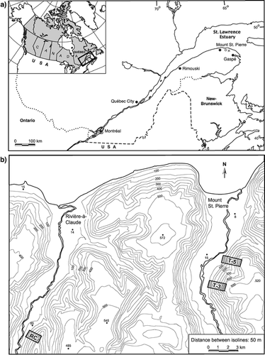
FIGURE 2. West-facing scree slopes a) T-5, b) T-3, and c) RC. The area devastated by the 1996 avalanche at stand T-5 is also shown in a)
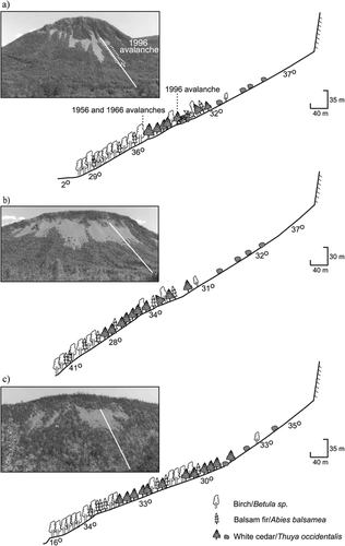
FIGURE 3. On the map, the heavy line marks the limit of the 1996-avalanche track at stand T-5. Tr-1 to Tr-3 (dashed lines) identify the three transects used for the study of tree damage, and numbers identify the position of damaged trees used for the reconstruction of past avalanche activity. a) to c) Distribution of dead and living white cedar and balsam fir stems in the three transects (dashed line), using four categories of damaged trees
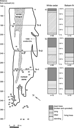
FIGURE 4. Event-response histograms for inception of reaction wood (a to c) in each study stand and d) all stands. Horizontal dotted line = 10% threshold index. Curves refer to total number (N) of samples. Black bars: n ≥ 10; light bars (in b and c: n < 10)
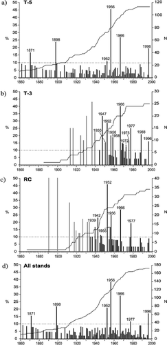
FIGURE 5. Dates of leader initiation on damaged trees from stand T-5. Arrows show avalanche year inferred from tree-rings, except (1982), a nonavalanche year
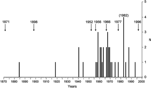
FIGURE 6. Avalanches at stand T-5 mapped based on the position of trees damaged during the 1956 (▴) and 1966 (•) events and on direct field observations after the 1996 event
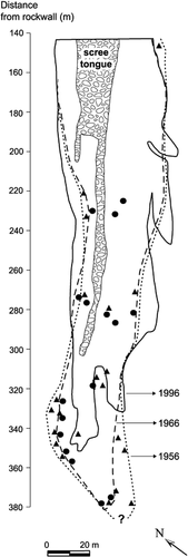
FIGURE 7. Departures (solid bars) from average snowfalls (330 cm) at weather stations Cap-Madeleine (1885–1994) and Grande-Vallée (1995–2000). Minimum departure values (open bars) derived from incomplete monthly snowfall records (<1 mo within the snow season). Missing snowfall records (hatched bars) for > 1 mo within the snow season. (1969) indicates a nonavalanche year from our tree-ring records
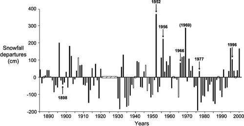
TABLE 1 Distribution (N) of living and dead white cedar and balsam fir in transects Tr-1 to Tr-3 and mean tree diameters (Md)
TABLE 2 Number of occurrences, return interval, and probability (%) of high-magnitude avalanches at the three study stands
TABLE 3 Seasonal and total snowfall (cm) from Cap-Madeleine and Grande-Vallée* weather stations, for high-magnitude avalanche years deduced from tree-rings at each study site
Acknowledgments
We thank Violaine Lafortune, Stéphane Babin, and the late Stéphane Beaudoin for assistance in the field; Chantal Lemieux and Ann Delwaide for help in the preparation of the manuscript;, and two reviewers for their comments. The Natural Sciences and Engineering Research Council of Canada and the Fonds pour la formation de chercheurs et l'aide à la recherche (FCAR) supported this research through grants to L. F and B. H.
Related Research Data
References Cited
- Bégin, Y. 1990. The effects of shoreline transgression on woody plants, Upper St. Lawrence Estuary, Québec. Journal of Coastal Research 6:815–827.
- Bégin, C. and L. Filion . 1999. Black spruce ( Picea mariana ) architecture. Canadian Journal of Botany 77:664–672.
- Blikra, L. H. and S. F. Selvik . 1998. Climatic signals recorded in snow avalanche-dominated colluvium in western Norway: depositional facies successions and pollen records. The Holocene 8:631–658.
- Boucher, D. , L. Filion , and B. Hétu . 2003. Reconstitution dendrochronologique et fréquence des grosses avalanches de neige dans un couloir subalpin du mont Hog's Back, Gaspésie centrale (Québec). Géographie physique et Quaternaire, 57: in press.
- Burrows, C. J. and V. L. Burrows . 1976. Procedure for the study of snow avalanche chronology using growth layers of woody plants. University of Colorado, Institute of Arctic and Alpine Research Occasional Paper, 23. 54 pp.
- Butler, D. R. and G. P. Malanson . 1985a. A history of high-magnitude snow avalanches, Southern Glacier National Park, Montana, U.S.A. Mountain Research and Development 5:175–182.
- Butler, D. R. and G. P. Malanson . 1985b. A reconstruction of snow-avalanche characteristics in Montana, U.S.A., using vegetative indicators. Journal of Glaciology 31:185–187.
- Carrara, P. E. 1979. The determination of snow avalanche frequency through tree-ring analysis and historical records at Ophir, Colorado. Geological Society of America Bulletin, Part I 90:773–780.
- Environnment Canada, 1992. Normales climatiques au Canada 1961–1990 : Québec. Ottawa, Canada: Service de l'Environnement atmosphérique.
- Enos, P. C. 1969. Cloridorme Formation Middle Ordovician Flysch, Northern Gaspé Peninsula, Québec. Geological Society of America. Special Paper 117. 66 pp.
- Fitzharris, B. B. and P. A. Schaerer . 1980. Frequency of major avalanche winters. Journal of Glaciology 26:43–52.
- Föhn, P. M B. 1992. Climatic change, snow-cover and avalanches. Catena Supplement 22:11–21.
- Gagnon, R. M. 1970. Le climat des Chic-Chocs. Ministère des Richesses naturelles du Québec, Service de la météorologie, Rapport M.-P. 36. 103 pp.
- Girard, J-F. and B. Hétu . 1989. Le Mont-Albert, Parc de la Gaspésie : Inventaire des avalanches et cartographie des zones à risques. Unpublished Report, Département de géographie, Université du Québec à Rimouski, Rimouski, Québec, Canada. 36 pp.
- Hétu, B. 1990. Évolution récente d'un talus d'éboulis en milieu forestier, Gaspésie, Québec. Géographie physique et Quaternaire 44:199–215.
- Hétu, B. 1992. Coarse cliff-top aeolian sedimentation in Northern Gaspésie, Québec (Canada). Earth Surface Processes and Landforms 17:95–108.
- Hétu, B. and J. T. Gray . 2000. Effects of environmental change on scree slope development throughout the postglacial period in the Chic-Choc Mountains in the northern Gaspé Peninsula, Québec. Geomorphology 32:335–355.
- Hétu, B. and P. Vandelac . 1989. La dynamique des éboulis schisteux au cours de l'hiver, Gaspésie septentrionale, Québec. Géographie physique et Quaternaire 43:389–406.
- Hétu, B. , J-F. Girard , and J. Boisjoly . 1994. Les risques naturels reliés à la dynamique des versants dans le nord de la Gaspésie : zone littorale et mont Albert. Bulletin de l'Association québécoise pour l'étude du Quaternaire 20:9–15.
- Jamieson, B. 1997. Backcountry Avalanche Awareness. Revelstoke: Canadian Avalanche Association. 42 pp.
- Johnson, E. A. 1987. The relative importance of snow avalanche disturbance and thinning on canopy plant populations. Ecology 68:43–53.
- Jomelli, V. and P. Bertran . 2001. Wet snow avalanche deposits in the French Alps: structure and sedimentology. Geografiska Annaler 83A:15–28.
- Keylock, C. 1997. Snow avalanches. Progress in Physical Geography 21:481–500.
- Lachapelle, E. R. 1977. Snow avalanches: a review of current research and applications. Journal of Glaciology 19:313–324.
- Lafortune, M. , L. Filion , and B. Hétu . 1997. Dynamique d'un front forestier sur un talus d'éboulis actif en climat tempéré froid (Gaspésie, Québec). Géographie physique et Quaternaire 51:67–80.
- Larocque, S. , B. Hétu , and L. Filion . 2001. Geomorphic and dendroecological impacts of slushflows in Central Gaspé Peninsula (Québec, Canada). Geografiska Annaler 83A:191–201.
- Luckman, B. 1977. The geomorphic activity of snow avalanches. Geografiska Annaler 59A:31–48.
- Mattheck, C. and H. Kubler . 1995. Wood–The internal optimization of trees. New York: Springer. 129 pp.
- Matthews, J. A. and D. McCarroll . 1994. Snow-avalanche impact landforms in Breheimen, Southern Norway: origin, age, and paleoclimatic implications. Arctic and Alpine Research 26:103–115.
- McClung, D. M. and P. A. Schaerer . 1993. The Avalanche Handbook. Seattle: Mountaineers. 271 pp.
- Patten, R. S. and D. H. Knight . 1994. Snow avalanches and vegetation pattern in Cascade Canyon, Grand Teton National Park, Wyoming, U.S.A. Arctic and Alpine Research 26:35–41.
- Potter Jr., N. 1969. Tree-ring dating of snow avalanche tracks and the geomorphic activity of avalanches, northern Absaroka Mountains, Wyoming. Geological Society of America, Special Paper 123:141–165.
- Rayback, S. A. 1998. A dendrogeomorphological analysis of snow avalanches in the Colorado Front Range, USA. Physical Geography 19:502–515.
- Shroder Jr., J. F. 1978. Dendrogeomorphological analysis of mass movement on Table Cliffs Plateau, Utah. Quaternary Research 9:168–185.
- Shroder Jr., J. F. 1980. Dendrogeomorphology: review and new techniques of tree-ring dating. Progress in Physical Geography 4:161–180.
- Schneebeli, M. , M. Laternser , and W. Ammann . 1997. Destructive snow avalanche and climate change in the Swiss Alps. Eclogae Geologicae Helvetiae 90:457–461.
- Sigafoos, R. S. 1964. Botanical evidence of floods and flood-plain deposition. United States Geological Survey Professional Paper 485-A:1–35.
- Veblen, T. T. , K. S. Hadley , E. M. Nel , T. Kitzberger , M. Reid , and R. Villalba . 1994. Disturbance regime and disturbance interactions in a Rocky Mountain subalpine forest. Journal of Ecology 82:125–135.
- Walsh, S. J. , D. R. Butler , T. R. Allen , and G. P. Malanson . 1994. Influence of snow patterns and snow avalanches on the alpine treeline ecotone. Journal of Vegetation Science 5:657–672.