Abstract
Pårteglaciären in northern Sweden has a response time of ∼200 years, demonstrating a long response time for a continentally located glacier. Pårteglaciären is a polythermal valley glacier presently covering an area of 10 km2. Its size will be reduced another 60–70% if the present climate persists and will then only have ∼30% of its Little Ice Age maximum volume left. Future global warming will of course enhance melt rates, and the relative size and volume reduction will probably be even larger. Photogrammetric studies between 1963 and 1992 show a general thinning of the entire glacier except for the center one of the three cirques in the accumulation area, which seems to have a surface elevation in balance with present climate. Balanced flow studies performed using GPS and Ground Penetrating Radar at the outlet of the cirques gave negative values for two cirques and a positive value for the center cirque. The future Pårteglaciären will split up into three small glaciers, and only the center one will extend beyond its cirque.
Introduction
As a response to climate warming we expect glaciers to become smaller. Temperature changes are powerful controls on glacier extent, and data on glacier fluctuation are therefore often referred to as a good proxy for climate change. Small changes in any climate parameter may cause significant changes in the mass balance of a glacier and the time for a glacier to adjust between two steady state positions can be estimated. Calculations based on kinematic wave theory shows response times in the range of 10–70 years for valley glaciers (CitationFolland et al., 2001). Having no information on the state of the mass balance of a specific glacier, the estimated response time reflects the time resolution in the data on glacier front changes. A retreating glacier tells us that its mass balance was reduced due to climate recently, or some time in the past. The significant climate warming at the termination of the Little Ice Age caused glacier retreat in northern Scandinavia starting around 1910 (CitationHolmlund, 1993). At the beginning of the 21st century many glaciers in Sweden have adapted their sizes to the warm 20th century climate but many glaciers are still responding to the warming which started approximately 100 years ago. There are at least two reasons for the fact that many glaciers are still responding to the warming that began with the termination of the Little Ice Age. First, the theory on which calculations of response time is based assumes small changes in mass balance. Second, calculations have no control on the actual energy balance.
In dry environments glaciers form a gently sloping longitudinal surface profile. Such glaciers are extremely sensitive to changes in equilibrium line altitude changes. A 1° warming may reduce the accumulation area ratio from 50–60% to 10–20% causing a dramatic change in glacier extent. A glacier may lose more than half its size, and the topographic influence on ice flow regime will get considerably stronger. Continentally located glaciers have a low rate of mass turnover and surface ice velocities are low, especially in cold environments. If mass balance on such a glacier is reduced such that it is significantly negative it may still take hundreds of years to remove the ice volume, which cannot be supported by the accumulation area. Due to high melt rates this process is quicker in maritime areas.
In the continental parts of the Swedish mountains many glaciers are retreating as most glaciers in the Arctic. In this paper we discuss the climatic significance of these retreat records from dry climate environments with respect to a study of Pårteglaciären in northern Sweden. In the following sections we closely examine changes in mass and size, and relate this to the climate during the last 100 years. In 1965 the glacier was included in the Tarfala Research Station glacier front monitoring program (CitationSchytt, 1968), and we use these measurements to evaluate the retreat since the 1960s. The annual mass balance was measured over the period 1997 to 2002 using a method with traditional manual snow probing and stake measurements. For long-term changes in mass and size we used photogrammetric methods to calculate the changes between digital elevation models. An analysis of the balance velocity and response time was also undertaken in order to examine the dynamics of the glacier. To calculate the balance velocity we used and analyzed the ice depth from multifrequency radar measurements using monopulsed radar techniques. Ice velocity measurements were also performed in order to support the balance velocity analysis. Through qualitative arguments and quantitative measures we give an estimate of the response time for the glacier by using the present mass balance measurements, long-term volume and size changes, and ice depths.
Background
PÅRTEGLACIÄREN
Pårteglaciären (67°10′N, 17°40′E; and ) is a polythermal valley glacier located in the Pårte massif in the southernmost part of Sarek National Park, northern Sweden. The glacier covers 10 km2 and is 5.4 km long with a vertical extension from 1090 to 1760 m a.s.l. The accumulation area is divided into four cirques. The three largest cirques are oriented toward the east and the southernmost cirque is oriented toward the NE. CitationHamberg (1901a, Citation1901b, Citation1910) was the first to document and photograph the glacier ().
CLIMATE VARIATIONS
The pre-industrial climate variations during the past millennium show predominantly warm periods during approximately the 11th to 14th centuries (Medieval Warm Period) and cold periods during approximately the 17th to 19th centuries (Little Ice Age) (CitationLamb, 1985; CitationGrove 1988). CitationKarlén and Denton (1975) showed, using lichenometric measurements, that many Swedish glaciers reached their maximum extent or were close to their Holocene maximum during the Little Ice Age. The temperature in the northern part of Sweden was cold during the first part of the 19th century (CitationKlingbjer and Moberg, 2003). Based on CitationHamberg's (1910) ice velocity measurements at Mikkaglaciären, which is located ∼28 km north of Pårteglaciären, CitationHolmlund (1986) calculated the ice-flux and net balance gradient of Mikkaglaciären in the year 1900, and since temperatures were still low during the 19th century, Holmlund concluded that the glacier probably became thinner and smaller because of low precipitation. At the end of the 19th century climate in northern Scandinavia became more maritime (CitationWallén, 1986) and glaciers began to expand. The transition from the Little Ice Age to the 20th century warming was associated with glacier retreats. The glaciers located in more continental climates in Scandinavia, like Pårteglaciären, started the retreat one or two decades later than the glaciers in more maritime climates (CitationHolmlund, 1993). The reason for this delayed response is due to mass replacements and has nothing to do with the current climate. The period from 1910 to 1930 was characterized by a temperature increase, after which a strong cooling trend occurred until the 1970s. Warming then set in again. The precipitation in the area around Pårteglaciären has increased slowly since the end of the 19th century until the mid 1980s when it increased significantly.
It is expected that the global mean temperature will continue to increase in the 21st century as a response essentially to increased anthropogenic emissions of greenhouse gases, and that the warming will be largest at high latitudes in the Northern Hemisphere (CitationCubasch et al., 2001). This temperature increase must be taken into consideration when discussing future behavior of the glaciers in the Arctic and Subarctic.
Mass Balance Measurements
Mass balance was measured over the period 1997 to 2002 using a method with traditional manual snow probing and stake measurements as described by CitationØstrem and Brugman (1991) and CitationHolmlund and Jansson (1999). Approximately 100 to 150 snow depth probing profiles on the glacier determine the winter balance on Pårteglaciären. The locations of the profiles, exemplified by the 1996/1997 measurements, are shown in . The ablation stakes were placed along a longitudinal profile () to establish an ablation gradient. The summer balance was determined in early September by stake readings. During the stake readings in September 2000, ten ablation stakes were mapped and these have been used to evaluate the net mass balance and the net balance gradient for the years 2001 and 2002. The annual mass balance was converted to water equivalent (w.eq.) using density measurements made in snowpits during the snow depth probing.
The net mass balance for Pårteglaciären was negative for all years from 1997 to 2002 () and it has a strong correlation with the mean summer temperature for June–August (). The regression relationship obtained is b n = −0.293T JJA + 2.89. The correlation coefficient is 0.93 (R 2 = 0.86), i.e., 86% of the variance in the net mass balance is explained by the JJA mean temperature. The correlation is substantially less with the precipitation () (R 2 = 0.35), which was expected in dry local climate.
The mean net balance gradient, defined as the net mass balance as a function of altitude (CitationMeier, 1961; CitationShumskii, 1964) between 1997 and 2002 for Pårteglaciären, was calculated using linear regression between net balance and altitude, to 0.34 m 100 m−1 (, ). Low gradients are associated with continental climate and low mass turnover. High gradients are associated with high mass turnover and a maritime type of climate. Pårteglaciären has values between 0.25 and 0.47 (), which indicate a low gradient (CitationHaefeli, 1962).
The accumulation-area ratio (AAR) is a good proxy data for net mass balance. AAR is defined as the size of the accumulation area at the end of the melt season in relation to the total area of the glacier, expressed in percentage (CitationMeier, 1961). The relation between net balance and accumulation-area ratio has been found to be almost linear on glaciers (CitationMeier and Post, 1962), though the relation has to be empirically determined. The accumulation-area ratio () has been evaluated from maps and oblique aerial photos taken from a helicopter at the end of the melt season. The accumulation-area ratio for the years 2000 and 2002 was determined 2 to 3 weeks earlier than during 1997 to 1999 and 2001, and the accumulation-area ratio is therefore probably overestimated.
The combination of low accumulation-area ratio and the negative mass balance observed at Pårteglaciären coincides with other observations on local continental-located glaciers in Scandinavia (c.f. CitationKlingbjer, 2002, and CitationKjøllmoen, 2001). In contrast, maritime-located glaciers have been growing over the same period. For example, Engabreen on the Norwegian coast (150 km west of Pårteglaciären) has had a positive mass balance. The main reason for this difference in local climate is that the climate in the Scandinavian mountains is strongly affected by weather systems from NW, W, and SW, which indicate the influence of the west wind zone. This situation creates a strong climatological gradient (CitationEnquist, 1916). Since the mass balance measurement started by the Norwegian Water Resources and Energy Directorate in 1969, Engabreen has increased by 22 m w.eq. More than half of this increase has been accumulated since 1988 (CitationKjøllmoen, 1998). The large increase of precipitation in western Norway is probably due to a strong positive phase of the North Atlantic Oscillation (CitationFolland et al., 2001). During 2001 and 2002 the net mass balance on Engabreen has been negative. This is because of extremely low winter balance in 2001 (lowest since the start of the record in 1970) and an extremely hot summer in 2002 (Kjøllmoen, personal communication).
Glacier Size Changes
CHANGES IN GLACIER VOLUME
By calculating the difference between two digital elevation models (DEMs) separated in time, it is possible to receive a measure of elevation changes between them. This approach is especially suitable for long-term studies of glaciers changes. The DEMs enable us to calculate mean net mass balance, although they do not provide information on annual variations in accumulation and ablation. The congruence between traditional mass balance record and photogrammetric mass balance has been found generally good in many studies (e.g., CitationHolmlund, 1987; CitationAndreassen, 1999; CitationKrimmel, 1999). But the discrepancy can be large between the two methods. In a detailed study of Ålfotbreen in Norway made by CitationØstrem and Haakensen (1999), the glacier had increased in mass by 3.4 m w.eq. according to the traditional mass balance method. On the other hand, when they analyzed the results for the difference between two DEMs over the same 20 year period, the result showed that the glacier lost about 5.8 m w.eq. They concluded that this discrepancy was probably due to errors in the manual snow probing and stake measurements. The main errors were sinking of stakes in the firn areas and probing error in extreme snow depths (>10 m). In our case on Pårteglaciären, this is a minor problem because the snow depth on the glacier does normally not exceed 5–6 m and the ablation stakes were always frozen into the solid ice.
To quantify the long-term volume changes we have applied a photogrammetric mass balance approach. We calculated the area extent and volume change on Pårteglaciären by using DEMs of the glacier from 1963, 1980, and 1992, of which the latest is shown as a map in . Three aerial photo sets from National Land Survey of Sweden were used to create the models. The aerial photos, taken at the end of the melt season, had approximately the same amount of snow cover. From the DEMs of Pårteglaciären, volume changes were calculated for the periods 1963 to 1980 and 1980 to 1992. Five ground control points on well identifiable rocks were selected, in the vicinity of the corners on the photo set from 1992, and measured with static GPS (Trimble 4600 LS) during field work in August/September 1996. The same geodetic support was used on the 1963 and 1980 DEMs.
The most common approach in analytical photogrammetry is a regularly spaced grid in combination with break- and formlines. As a rule of thumb, the regular spacing should be chosen between 2 and 6 mm in the aerial photo (CitationAckermann, 1994). This rule can be adapted to various types of terrain. In order to preserve as much detail as possible on the glacier, 1.5 mm spacing was chosen, which corresponds to a 40 m grid size in the DEM. The grid was manually measured for all snow and ice covered areas on the glacier for all three sets. In a rugged terrain, like a mountain area of an alpine character, a higher density is needed to reproduce the landscape. The areas outside the glacier were therefore automatically collected with a grid space of 7.5 m. The DEM was then generated with the DEM software package SCOP (CitationSigle et al., 1991). Hereby, a newly interpolated DEM should have a grid space about 1/3 of the input grid space (CitationSigle et al., 1991). In this case we have used the 40 m grid and densified it to 15 m, with an algorithm based on the bell-curve (CitationNeidhart, 1999). This 15 m grid spaced DEM was used for all photogrammetric calculations. The accuracy of the DEMs is probably higher than the accuracy of a single data point. This is due to the fact that the program suppresses the scatter of the measured point and the DEM is smoothed. On a smooth rolling surface like Pårteglaciären, the DEM should therefore have a very high vertical accuracy.
The net loss of ice and snow from 1963 to 1992 is shown in and . It is clear that the lowering in surface elevation since 1963 is evenly spread over the glacier with a gradient from lower to higher elevation. The only exception is the accumulation area in the central cirque, which shows a minor or no decrease in elevation. The net loss of ice and snow between 1963 and 1992 corresponds to a mean surface lowering of −0.6 m a−1. The volume decrease between 1963 and 1980 is 139.9 × 10⁶ m3 and between 1980 and 1992 the decrease is 54.5 × 10⁶ m3. Presently the glacier volume is around 880 × 106 m3, covering an area of 10 km2 (CitationHolmlund and Jansson, 2003). Since 1963 the glacier has lost ∼200 × 106 m3 (∼20%). Assuming an area of 10–12 km2 and a more or less constant thinning of 0.6 m a−1 over the 20th century suggests a volume of ∼1.5 km3 at the termination of the Little Ice Age in 1910. Thus, the glacier has lost almost 40% of its Little Ice Age maximum volume. Given the current climate we expect a continuing mass loss trend. If we assume an area of 10 km2 and melt rate of 0.6 m a−1, Pårteglaciären will decrease another 60% in volume during the next 100 years. But, the area decreases during the volume reduction which implies that the measures may be slightly overestimated. If we instead decrease the area at a constant rate to 35% of the present size during the coming century (see next section), then the decrease in volume will be ∼475 × 106 m3 (∼54%) over the next 100 years. Future global warming would of course enhance melt rates, and the volume reduction would be even larger.
CHANGES IN GLACIER EXTENT
Changes in front positions reflect either a disturbed mass balance or annual variability in melt, or both. The advantage with glacier front position studies is the possibility of getting potentially well-distributed data on changes in glacier extent. The disadvantage is the significant delay between mass balance changes and frontal response. All available data on glacier front positions suggest that the retreat of glaciers started later at high latitudes than the glaciers at low and mid-latitudes (CitationFolland et al., 2001).
Since Pårteglaciären's Little Ice Age maximum extent, the glacier has retreated ∼750 m over gently sloping bedrock. The front retreat calculated from the digital elevation models from 1963 and 1992 totaled 322 m, and this coincides with the retreat calculated from repeated frontal surveys. During the last 10 years the retreat rate has been about 10 m a−1 and today there is no sign of a decrease in retreat rate. These results are in agreement with the general trend in Scandinavia, reported by CitationKjøllmoen (2001) and CitationWiklund and Holmlund (2002). Many large glaciers in Scandinavia are still retreating as a response to the early 20th century warming, even though the climate during the last 20 years has been favorable for a positive or neutral glacier mass balance. Locally in Sarek National Park, where Pårteglaciären is situated, the retreat follows the same pattern with a retreat since the 1960s ().
There are exceptions for this general retreat trend in Scandinavia. Along the Norwegian west coast, the glaciers have started to advance due to the high winter precipitation rate during the last 20 years. Engabreen on the Norwegian coast started to retreat rapidly in the 1930s, and the retreat lasted until around 1950. The rapid front retreat in the 1930s was enhanced by the occurrence of a proglacial lake. During 1990–2000, Engabreen had advanced 90 m (CitationKjøllmoen, 2001). A direct comparison between the retreat rates at Engabreen and Pårteglaciären is not possible due to differences in physical environments. The front on Engabreen is located close to the sea level along the Norwegian coast and Pårteglaciären's front is presently located at 1090 m a.s.l. The higher retreat rate at Engabreen can be explained by a much higher melt rate because of the lower elevation.
As a response to climate warming we expect Pårteglaciären to become smaller. The mean equilibrium line altitude between 1997 and 2002 was located ∼1550 m a.s.l. according to the net balance curves in . If we assume that the present shape of the net balance curve persists, the equilibrium line altitude has to be lowered to 1400 m a.s.l. in order to receive zero net mass balance. To establish a lowered equilibrium line altitude, a strong shift in climate toward cooler summers and more winter precipitation is needed. This situation is unlikely to occur during the 21st century due to the increase of anthropogenic emissions of greenhouse gases (CitationCubasch et al., 2001). By decreasing the total area to 65% in the ablation area and keeping the present net mass balance gradient (obtained from the curves in ), we may also reach a balanced mass balance. This is a more realistic situation according to the present mass balance measurements and the present climate predictions (CitationCubasch et al., 2001). Thus, the glacier is expected to decrease to ∼35% of the present size during the coming century.
Balance Velocity
BALANCE VELOCITY
Calculated balance velocity relates mass flux through a cross section to mass balance upstream (or downstream) of the cross section, assuming the principle of conservation of mass in an incompressible medium (e.g. CitationHooke, 1998). We can define the calculated balance velocity u
bal
as
where b
na
is the net mass balance upstream of the cross section, A
a
is the surface area upstream of the cross section, and A
c
is the cross-sectional area. In this study we have used the mean net mass balance between 1997 and 2000 in the area upstream of the cross section as a value for net mass balance in the area upstream of the cross section. The mean net mass balance we have used is close to the annual mass loss the last 40 years. The annual net mass balance between 1997 and 2000 averages −0.79 m w.eq () and the annual surface lowering during 1963 to 1992 averages 0.60 m (). We have calculated the balanced flow for each of the three cirques. The net balance gradient was calculated for each year between 1997 and 2000 using linear regression between net balance and altitude (, ). The balance velocities were calculated for the 1500 m contour line on the glacier, which approximately corresponds to the average equilibrium line altitude in the central cirque. The equilibrium line altitude is somewhat higher in the other two cirques. The cross-sectional areas were calculated from the ice depth, obtained from radar measurements.
ICE DEPTH MEASUREMENTS
We have used two different data sets to obtain the ice depth in the cross sections shown in . The first data set is based on a monopulsed ground penetrating radar survey in May and September 1992 (Nyman, written communication, 2003). Surveys were made along a longitudinal profile from the snout to the central cirque and along a cross profile at 1500 m a.s.l. in the central cirque (). The study shows that the cross section at 1500 m a.s.l. in the central cirque has a parabolic shape with a maximum depth of 125 m ± 10%.
The second data set used in this study was sampled in February and March 1996 from a helicopter using an airborne multifrequency radar. A Yagi antenna was used with frequencies centered at 345 MHz. This frequency is primarily used for airborne studies of cold surface layers on glaciers. The cold surface layer in the ablation areas on glaciers can be described thermally as a surface layer with ice temperatures below the pressure melting point (∼0°C) (CitationSchytt, 1968; CitationHooke et al. 1983; CitationHolmlund and Eriksson, 1989; CitationBlatter and Hutter, 1991; CitationKrass, 1991; CitationPettersson et al., 2003). Ice depth data from areas with ice temperatures below the pressure melting point (∼0°C) could only be evaluated due to penetration problems associated with the high frequency used. The multifrequency radar profiles are shown in . According to the airborne radar measurements, there is no sign of temperate ice below 1400 m a.s.l. at Pårteglaciären. Above 1400 m a.s.l. the ice is polythermal, in this case, cold surface ice and temperate ice at the bottom; therefore, the signal from the high frequency radar does not reach the bedrock. At 1500 m a.s.l. the depth of the cold surface layer is 140 m in the northern cirque. Since we do not know nor are we able to receive the ice depth of the temperate ice from the existing radar measurement, we can just say that the ice depth is at least 140 m. At 1500 m a.s.l. in the southern cirque the cold surface layer is 100 m deep. In this case also we are not able to determine the ice depth. Therefore the ice depth is at least 100 m. In this case we have assumed similar (parabolic) shapes of the cross sections. In reality we do not know the shape of the cross section in the northern and southern cirque. We do not even know the true ice depth; we only have information of the depth of the cold surface layer. For that reason we can calculate only a minimum value for the balance velocity. Since we do not know the shape of the cross section in the southern and northern cirques, we have examined the uncertainty by calculating the area also with a rectangular and a triangular shape.
ICE VELOCITY
Surface ice velocity measurements were carried out close to the 1500 m contour line at the outlet from the three cirques on the glacier (), which corresponds to the cross-sectional areas used for the calculation of the balance velocities. The repeated ice velocity surveys were made in August 2000 using differential GPS (Trimble 4600 LS). The measured error of the stake position in the drill hole was ±5 cm. The maximum distance between the base station, located over a ground-based fixed point, and the station used on different ice velocity stakes was 4 km. The time between the repeated surveys was 16 days. The velocity measurements were generally made close to the centerline where velocity is highest. Errors in the calculated surface velocities due to measurement techniques and time between surveys are less than ±1 cm and in this case negligible. The 16 days between the measurements is not representative for a full year. In August ice velocities are expected to be higher than the annual average. Studies on the polythermal Storglaciären in northern Sweden show summer velocities approximately 10% higher than the annual mean (CitationHooke et al. 1992). On a daily resolution, velocities can be up to 100% higher than the annual mean (CitationHooke et al., 1989). However, these data demonstrate the present difference in velocities between the three cirques.
Results
The results from the calculations based on Equation 1 show negative balance velocities in the southern (≥−4.5 m a−1) and northern cirques (≥−2.4 m a−1) and positive balance velocity (12.9 m a−1) in the central cirque (). Negative balance velocities from the southern and northern cirques indicate that the equilibrium line altitude is somewhat higher up. The produced net mass per year in those cirques is not sufficient to support the ablation area outside the cirques.
If we apply a rectangular or a triangular cross-sectional shape, then we receive a balanced velocity of −1.4 m a−1 or −3.2 m a−1 for the northern cirque. The corresponding values of balanced velocities for the southern cirque are −2.3 m a−1 and −4.9 m a−1 (). Even if we take these uncertainties regarding the cross-sectional shape into account, the result with a large difference between the central cirque and the northern and southern cirques will remain.
The results from the ice velocity measurements at the three stakes close to the 1500 m contour line also show a large difference between the central cirque and the northern and southern cirque (). The measured ice velocity in the central cirque is two times higher than in the southern cirque and more than six times higher than in the northern cirque.
RESPONSE TIME
Glaciers are generally not in balance with the existing climate and as a response to recent climate warming we expect most glaciers to became smaller. The response time for a glacier has been defined by CitationNye (1960) as the time between two steady-state conditions. It could also be described as the time required for a step change in mass balance to supply or lose the volume difference between the initial and final steady state. The time when a change is first observed at the terminus is much less than the response time and it does not necessarily have to reflect the change in mass balance (CitationEchelmeyer et al., 1996). Theoretical analyses based on kinematic wave theory made by CitationNye (1960, Citation1963) and later reviewed by CitationLliboutry (1971) and CitationHutter (1983) have indicated that glaciers could have response times of several hundreds of years. On the other hand, CitationJohannesson et al. (1989a, Citation1989b) argued that there is a discrepancy between the theoretical model and the record of past glacier and climate fluctuations. All these theoretical models assume a small step in mass balance.
CitationJohannesson et al. (1989a, Citation1989b) proposed a simplified analytical model where the response time t is proportional to the glacier thickness h max and inversely proportional to the net balance b n at the terminus. In this case the response time will grow linearly with the glacier thickness. If the glacier grows larger because of an increase in mass balance, then the glacier will advance at the snout. With everything else constant, this change in elevation will increase the ablation at the terminus and the response time will decrease (CitationBahr et al., 1998). The mean net ablation rate on the lower part of Pårteglaciären averages ∼1.5 m w.eq. a−1 and the maximum thickness over the central part is at least 140 m, and by using the CitationJohannesson et al. (1989a, Citation1989b) model this will give a response time of ∼100 years. CitationHarrison et al. (2001) on the other hand suggested a modified model, which only takes the effect of surface elevation on mass balance into account. In this model the response time t is t[b e , H, G e ], where b e is the specific balance rate at the terminus, H is the thickness scale, and G e is the balance-rate gradient. Following the CitationHarrison et al. (2001) idea by using a thickness of 140 m, a net ablation rate of ∼1.5 m w.eq a−1, and a balance-rate gradient of ∼0.004 mm a−1 (obtained from the curves in ), the response time will be ∼150 years. CitationBahr et al. (1998) showed that the response time depends on the mass balance index, defined as the slope of the balance curve as a function of horizontal distance. The balance index is typically larger for small glaciers and they will therefore respond faster than larger glaciers. This quicker response is because of mass balance considerations and not because of the glacier dynamics. A maritime glacier will have a higher index than a glacier located in an area with more continental climate.
The behavior of glaciers in Scandinavia has been discussed by CitationHolmlund (1993) and one of his conclusions is that Scandinavian glaciers somewhat differ in behavior from alpine glaciers in southern and central Europe. The Scandinavian glaciers are generally flatter and colder. This implies longer time periods between two steady state conditions for the glaciers. Pårteglaciären is located in an area with a local continental climate, and the glacier is comparatively large for being a Scandinavian glacier. Based on the CitationBahr et al. (1998) discussion, a relative long response time is expected for the glacier. The theoretical calculations for Pårteglaciären suggest response times between 100 and 150 years.
Pårteglaciären's net mass balance is strongly correlated with the mean summer temperature (), and if the present climate persists, then the glacier will continue to lose mass until a new steady state condition is reached. Irrespective of the theoretical calculations, the net loss per year is still low and it will take a very long time to remove the ice volume that cannot be supported by the accumulation area. This response of the glacier is due to mass balance effects and not because of the glacier dynamics. The ice depth at the cross sections in the outlets from the cirques varies between ≥100 and ≥140 m (). With a melt rate of ∼0.6 m per year it will take at least 160 to 230 years to remove the ice.
Conclusions
Pårteglaciären has retreated and has undergone a mass loss of ∼0.6 km3 during the 20th century. We have calculated the response time to be ∼200 years demonstrating the long response time for a continentally located glacier. Pårteglaciären is expected to decrease to ∼35% its present size during the coming century. Future global warming will of course enhance melt rates and the size reduction will be even larger. The balanced flow studies gave negative values for two cirques and a positive balanced flow in the center cirque. A future 65% reduction of the total area will split up Pårteglaciären in three small glaciers. Since the balanced flow studies gave positive values in the center cirque, only the center one will reach outside its cirque.
Thus, fluctuations in terminus recession rate rather reflect intra-annual variability in melt rate, uneven subglacial topography, and rate of adaptation to a new steady state size. The temporal resolution in proxy climate data for glacier front observations in continental subarctic areas is thus 100–200 years, unless no other information on mass balance is available.
The glacier has lost almost 40% of its Little Ice Age maximum volume. The increase in temperature beginning in the 20th century will lead to a total volume reduction of ∼70%. Future global warming would of course enhance melt rates and the volume reduction would be even larger.
FIGURE 1. Location map for sites mentioned in the text
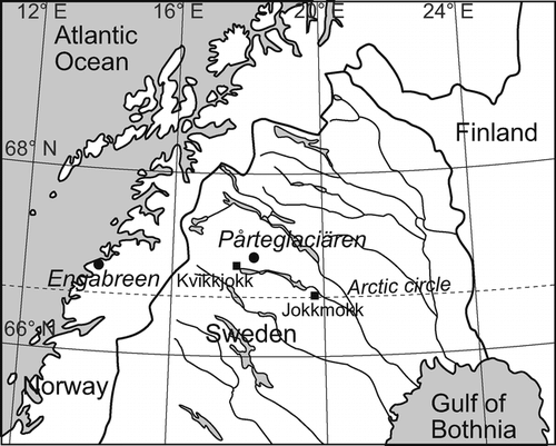
FIGURE 2. Pårteglaciären photographed by (a) Axel Hamberg on 4 September 1901 (reproduced from Hamberg, 1908) and (b) Per Klingbjer on 21 August 2000
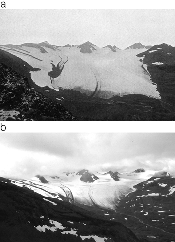
FIGURE 3. (a) Map of surface topography of Pårteglaciären in 1992. Contour interval 20 m. The map shows snow depth probing profiles (thin line) and ablation stake positions (marked with x) for the mass balance year 1996/1997. The map also shows the cross-sectional profiles (thick line) and ice velocity stake positions (marked with Δ) close to the 1500 m contour line. (b) Net loss of ice (m) between 1963 and 1992 at Pårteglaciären. The black area on the glacier represents a minor decrease in elevation or no change at all. The outermost contour line is the extent of the glacier in 1963 and the inner contour is the extent in 1992. The white area between the contour lines represents the retreat of the glacier
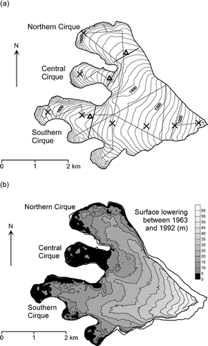
FIGURE 4. Correlation between (a) summer temperature (JJA), and (b) winter precipitation (ONDJFMA) in Kvikkjokk and net mass balance (m w.eq.) at Pårteglaciären for 1997–2002
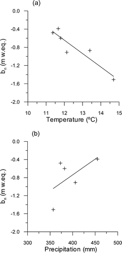
FIGURE 5. Mass balance (line) and glacier area distribution (bars) as a function of altitude for Pårteglaciären between 1996/1997 and 2001/2002. (a) The net mass balance (b n ) and (b) the summer (b s ) and winter balance (b w )
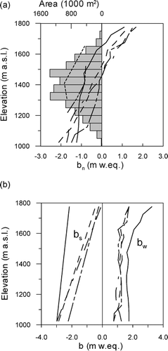
FIGURE 6. Cumulative length changes of glaciers in Sarek National Park and Sulitelma massif since the 1960s
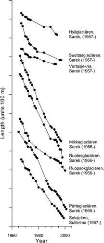
FIGURE 7. Net mass balance (b n ) for the three main cirques at Pårteglaciären between 1996/1997 and 1999/2000
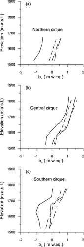
FIGURE 8. The ice depth and the depth to the cold-temperature transition surface at Pårteglaciären. Results from the airborne multifrequency radar at 345 Mhz center frequency (a, b, d, and f), and monopulsed ground penetrating radar at 8 Mhz (c and e)
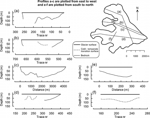
TABLE 1 Annual measurements of net mass balance (b n ), equilibrium line altitude (ELA), and accumulation area ratio (AAR) between 1989/1990 and 2001/2002. Calculated net balance gradient, nbg (m/100m), at Pårteglaciären between 1996/1997 and 2001/2002
TABLE 2 Area changes (km2), volume changes (106 m3), and mean annual net surface lowering (m) for Pårteglaciären
TABLE 3 Calculated net balance gradient, nbg (m/100m) for the three cirques at Pårteglaciären between 1996/1997 and 1999/2000
TABLE 4 Calculated balance velocity (u bal ) through three cross sections (A c ) at 1500 m a.s.l in the three cirques at Pårteglaciären. The mean net mass balance (b na ) is given as meters of water equivalent (w.eq.) between 1997 and 2000, above cross section at 1500 m a.s.l. The surface area upstream (A a ) is given of the cross section at 1500 m a.s.l. Also given is the measured surface velocity at centerline of cross-section surface (u s )
Acknowledgments
The fieldwork for Per Klingbjer was financed by grants from the Andrée foundation, Göran Gustavsson's foundation, Swedish tourist association's foundation for scientific research, Axel Hamberg's foundation, Lars Hierta's foundation, and the Ájttes research foundation. We thank Hans Alexandersson at Swedish Meteorological and Hydrological Institute for the Jokkmokk temperature and precipitation data. We thank Ian Brown for correcting the English. Per Holmlund, Peter Jansson, and Stig Jonsson are also thanked for their comments on the scientific content in the article. We also would like to thank Per Holmlund letting us use his unpublished multifrequency radar data and Mart Nyman for letting us use his monopulsed radar measurements. Last, but not least, we would like to thank the staff at Tarfala Research Station for their assistance in the field.
References Cited
- Ackermann, F. 1994. Digital elevation models-techniques, and application, quality standards, development. Proceedings, Symposium on mapping and geographic information systems, ISPRS 30:421–432.
- Andreassen, L. M. 1999. Comparing mass balance measurements with long term volume change extracted from topographical maps: A case study of Storbreen glacier in Jotunheimen, Norway, for the period 1940–1997. Geografiska Annaler 81:467–476.
- Bahr, D. B. , W. T. Pfeffer , C. Sassolas , and M. F. Meier . 1998. Response time of glaciers as a function of size and mass balance: 1. Theory. Journal of Geophysical Research 103:B5 9777–9782.
- Blatter, H. and K. Hutter . 1991. Polythermal conditions in arctic glaciers. Journal of Glaciology 37:261–269.
- Cubasch, U. , G. A. Meehl , G. J. Boer , R. J. Stouffer , M. Dix , A. Noda , C. A. Senior , S. Raper , and K. S. Yap . 2001. Projections of Future Climate Change. In Houghton, J. T., Ding, Y., Griggs, D. J., Noguer, M., van der Linden, P. J., Dai, X., Maskell, K., and Johnson, C. A. (eds.), Climate Change 2001: The Scientific Basis. Contribution of Working Group I to the Third Assessment Report of the Intergovernmental Panel on Climate Change. Cambridge: Cambridge University Press, 881 pp.
- Echelmeyer, K. A. , W. D. Harrisson , C. F. Larsen , J. Sapino , J. E. Mitchell , J. DeMallie , B. Rabus , G. Adalgeirsdottir , and L. Sombardier . 1996. Air-borne surface profiling of glaciers: A case study in Alaska. Journal of Glaciology 42:538–547.
- Enquist, F. 1916. Der Einfluss des Windes auf die Verteilung der Gletscher. Bulletin of Geological Institution of the University of Uppsala, 14: 108 pp.
- Folland, C. K. , T. K. Karl , J. R. Christy , R. A. Clarke , G. V. Gruza , J. Jouzel , M. E. Mann , J. Oerlemens , M. J. Salinger , and S-W. Wang . 2001. Observed climate variability and change. In Houghton, J. T., Ding, Y., Griggs, D. J., Noguer, M., van der Linden, P. J., Dai, X., Maskell, K., and Johnson, C. A. (eds.), Climate Change 2001: The Scientific Basis. Contribution of Working Group I to the Third Assessment Report of the Inter-govern-mental Panel on Climate Change. Cambridge: Cambridge University Press, 881 pp.
- Grove, J. M. 1988. The Little Ice Age. London: Methuen, 498 pp.
- Haefeli, R. 1962. The ablation gradient and retreat of a glacier tongue. IASH Publication 58:49–59.
- Hamberg, A. 1901a. Sarekfjällen, en geografisk undersökning. Ymer 21:145–204.
- Hamberg, A. 1901b. Sarekfjällen, en geografisk undersökning. Ymer 21:223–276.
- Hamberg, A. 1910. Die gletscher des Sarekgebirges und ihre untersuchung. Sveriges Geologiska Undersökning Ser. Ca, 5:3 1–21.
- Harrison, W. D. , D. H. Elsberg , K. A. Echelmeyer , and R. M. Krimmel . 2001. On the characterization of glacier response by a single time-scale. Journal of Glaciology 47:659–664.
- Holmlund, P. 1986. Mikkaglaciären: Bed topography and response to 20th century climate change. Geografiska Annaler 68:291–302.
- Holmlund, P. 1987. Mass balance of Storglaciären during the 20th century. Geografiska Annaler 69:439–447.
- Holmlund, P. 1993. Surveys of post–Little Ice Age glacier fluctuations in northern Sweden. Zeitschrift für Gletscherkunde und Glazialgeologie 29:1–13.
- Holmlund, P. and M. Eriksson . 1989. The cold surface layer on Storglaciären. Geografiska Annaler 71:241–144.
- Holmlund, P. and P. Jansson . 1999. The Tarfala mass balance program. Geografiska Annaler 81:621–631.
- Holmlund, P. and P. Jansson . 2003. Glaciologi. Stockholm: Stockholms universitet, Vetenskapsrådet, 176 pp.
- Hooke, R. L. 1998. Principles of Glacier Mechanics. New Jersey: Prentice Hall, 248 pp.
- Hooke, R. LeB. , J. E. Gould , and J. Brzozowski . 1983. Near-surface temperatures near and below the equilibrium line on polar and subpolar glaciers. Zeitschrift für Gletscher-kunde und Glazialgeologie 19:1–25.
- Hooke, R. LeB. , P. Calla , P. Holmlund , M. Nilsson , and A. Stroeven . 1989. A 3 year record of seasonal variations in surface velocity, Storglaciären, Sweden. Journal of Glaciology 35:235–247.
- Hooke, R. LeB. , V. A. Pohjola , P. Jansson , and J. Kohler . 1992. Intra-seasonal changes in deformation profiles revealed by borehole studies, Storglaciären, Sweden. Journal of Glaciology 38:348–358.
- Hutter, K. 1983. Theoretical Glaciology. Dordrecht: Rediel, 510 pp.
- Johannesson, T. , C. F. Raymond , and E. D. Waddington . 1989a. A simple method for determining the response time of glaciers. In Oerlemans, J. (ed), Glacier fluctuations and climatic change. Dordrecht: Kluwer Academic Publishers, 343–352.
- Johannesson, T. , C. F. Raymond , and E. D. Waddington . 1989b. Time-scale for adjustment of glaciers to changes in mass balance. Journal of Glaciology 35:355–369.
- Karlén, W. and G. H. Denton . 1975. Holocene glacial variations in Sarek National Park, northern Sweden. Boreas 5:25–56.
- Kjøllmoen, B. (ed.),. 1998. Glaciological investigations in Norway 1996 and 1997. Norwegian Water and Energy Directorate (NVE), Report No. 20: 134 pp.
- Kjøllmoen, B. 2001. Glaciological investigations in Norway 2000. Norwegian Water and Energy Directorate (NVE), Report No. 2: 140 pp.
- Klingbjer, P. (ed.),. 2002. Tarfala Research Station Annual report, 1999–2000 and 2000–2001. Reports from the Department of Physical Geography and Quaternary Geology No 1. Stockholm: Stockholm University, 92 pp.
- Klingbjer, P. and A. Moberg . 2003. A composite monthly temperature record from Tornedalen in northern Sweden, 1802–2002. International Journal of Climatology 23:1465–1494.
- Krass, M. S. 1991. Formation of the thermal regime of sub-polar glaciers under climate change. IAHS Publication 208:515–525.
- Krimmel, R. M. 1999. Analysis of difference between direct and geodetic mass balance measurements at South Cascade glacier, Washington. Geografiska Annaler 81:653–658.
- Lamb, H. H. 1985. Climatic History and the Future. London: Methuen, 835pp.
- Lliboutry, L. A. 1971. The glacier theory. In Ven Te Chow (ed.), Advances in Hydrodynamics, volume 7. New York: Academic Press, 81–167.
- Meier, M. F. 1961. Mass budget of South Cascade Glacier, 1957–60. U.S. Geological Survey Professional Paper 424-B: 206–211.
- Meier, M. F. and A. S. Post . 1962. Recent variations in mass net budgets of glaciers in western North America. IASH Publication 58:63–77.
- Neidhart, F. 1999. The mapping of Pårteglaciären and the analysis of its changes from 1963–1996. In Klingbjer, P. (ed.), Tarfala Research Station Annual Report 1997–98. Stockholm: Stockholm University, Department of Physical Geography, Research Report 110: 23–25.
- Nye, J. F. 1960. The responce of glaciers and ice-sheets to seasonal and climatic changes. Proceedings of the Royal Society Series A, 256:559–584.
- Nye, J. F. 1963. On the theory of glacier advance and retreat of glaciers. Geophysical Journal of the Royal Astronomical Society 7:431–456.
- Østrem, G. and M. Brugman . 1991. Glacier mass balance measurements. A manual for field and office work. Saskatoon, Saskatchewan, Environment Canada (ISBN 0-662-19000-9), and National Hydrology Research Institute (ISSN 0843-9052), NHRI Science Report 4, 224 pp.
- Østrem, G. and M. Haakensen . 1999. Map comparisons or traditional mass balance measurements: which method is better?. Geografiska Annaler 81:703–711.
- Pettersson, R. , P. Jansson , and P. Holmlund . 2003. Cold surface layer thinning on Storglaciären, Sweden, observed by repeated ground penetrating radar surveys. Journal of Geophysical Research 108:F1 6004. doi: 10.1029/2003JF000024.
- Schytt, W. 1968. Notes on the glaciological activities in Kebnekaise, Sweden during 1966 and 1967. Geografiska Annaler 50:111–120.
- Shumskii, P. A. 1964. Principles of Structural Glaciology. New York: Dover Publications, 497 pp.
- Sigle, M. , O. Hellwich , and A. Köstli . 1991. Intersection and combination of digital elevation models—methods and applications. White paper—INPHO, GmbH, Stuttgart. Available at the University of Stuttgart.
- Wallén, C. C. 1986. Impact of present century climate fluctuations in the Northern Hemisphere. Geografiska Annaler 68:245–278.
- Wiklund, M. and P. Holmlund . 2002. Swedish glacier front monitoring program—compilation of data from 1990 to 2001. In Klingbjer, P. (ed.), Tarfala Research Station Annual Report, 1999–2000 and 2000–2001. Stockholm: Reports from the Department of Physical Geography and Quaternary Geology No 1, Stockholm University, 37–40.