Abstract
Changes in the amount of soil organic carbon (SOC) stored in arctic soils may influence the global carbon cycle and be an important feedback mechanism to global climate changes. In order to estimate the carbon stock and accumulation rates at Flakkerhuk on Disko Island in West Greenland, an 1800-ha study area was divided into land cover types using a satellite image. Total SOC was estimated to be on average 67.3 ton C ha−1 (6.7 kg m−2) and the fen area contributing 42% of the total SOC. Soil profiles investigated at different terraces revealed that the SOC stock was significantly age-related, increasing six fold from a terrace dated to 7000 (BP) to one dated to 10,000 (BP). This equals an average soil C accumulation rate of 0.5 kg C m−2 100 yr−1. This rate was compared to vegetation-specific accumulation rates in the last 7000 yr which were in the order of 0.05 kg C m−2 100 yr−1 in heath and sparse vegetation, 0.4 in fen areas and between 2 and 5 kg C m−2 the last 100 yr in the present salt marsh. The study shows the importance of landscape history and age when sampling and evaluating SOC stocks and provides estimates of arctic soil C accumulation rates during Holocene versus present rates.
Introduction
Arctic soils represent an important reservoir for soil organic carbon (SOC) and may be some of the most sensitive soils with respect to climatic changes (CitationOechel et al., 1993; CitationGilmanov and Oechel, 1995; CitationMaxwell, 1997; CitationIPCC, 2001). The amount of SOC stock needs to be quantified, as even small changes in the current stock may act as an important feedback mechanism with respect to global C budgets (CitationOechel and Billings, 1992). Current fluxes between carbon (C) reservoirs are almost equal at arctic latitudes (CitationSøgaard and Nordstrøm, 1999) resulting in small net effects on ecosystem C reservoirs. Despite of small current net effects, large quantities of SOC has been stored in arctic ecosystems the past thousands of years (CitationBillings, 1987; CitationHobbie et al., 2000; CitationBockheim et al., 2004) primarily as a result of slow decomposition rates due to low temperatures and permafrost. Topography, water availability, and vegetation composition are additional important factors resulting in spatial variations in SOC storage (e.g., CitationHobbie et al., 2000; White et al., 2003). Thus, further attention should be given to historical as well as present accumulation rates of organic matter in various arctic soil systems.
In contrast to the large number of studies of C-fluxes by eddy covariance and chamber measurements in the Arctic (CitationVourlitis and Oechel, 1999; CitationJones et al., 2000; CitationElberling et al., 2004), relatively few studies have focused on the net effect of these C-fluxes in terms of a net gain or loss of SOC. One of the reasons is the uncertainties regarding current estimates of SOC storage in arctic soils. CitationPost et al. (1982) is often cited for the finding that arctic soils hold about 14% of the world's organic carbon, while CitationWhite et al. (2004) estimated that 25 to 30% of the world's soil carbon is stored in soil affected by permafrost. CitationGilmanov and Oechel (1995) estimated the soil organic matter of the active layer in tundra ecosystems in North America and Greenland to be 91.3 Gt. All of these estimates are based on extrapolating point measurements of soil data to larger areas without considering the age of the landscape despite the fact that variable ages along with other soil forming factors (parent material, topography, organisms, and climate) within a study area can be important for the accuracy of extrapolating. Furthermore, considering the age of soils may provide important information on current and historical SOC accumulation rates (CitationAdams and Faure, 1998).
CitationAdams and Faure (1998) reviewed global carbon storage during the last 18,000 yr on the basis of land ecosystem reconstruction and indicated the importance of land ecosystem reconstruction for estimating C storage on land. CitationBillings (1987) evaluated C budgets for peaty soils beneath the wet coastal tundra at Barrow, Alaska, on the basis of fossil pollen, plant macrofossil spectra, and present vegetation. Although C accumulation rates have varied, it was shown that the tundra soils have accumulated on average 22 g C m−2 yr−1 the last 4800 yr. CitationBockheim et al. (2004) studied Arctic carbon accumulation rates on the basis of spatial and temporal variations in SOC within drained thaw lake basins in Alaska. That study reported a significant age-related difference in stored SOC. Results of CitationBillings (1987) and CitationBockheim et al. (2004) indicate the importance of knowing the age of soils prior to soil sampling and before point measurements of soil stocks are extrapolated to larger areas.
The objective of this study was to quantify the spatial distribution of SOC stocks within land cover and vegetation types in a study area in Disko Bugt, West Greenland (between 68–69°N and 50–54°W). The region is characterized by dramatic sea-level changes and isostatic rebound during Holocene, which have resulted in that raised shorelines are common and easily identified in the landscape up to 60 m above present sea level. Sea-level changes in the last 10,000 yr in the area have been studied intensively on the basis of dated shorelines (CitationDonner and Jungner, 1975; CitationRasch and Nielsen, 1995; CitationRasch, 1997; CitationLong et al., 1999). This allows an investigation of SOC accumulation with respect to vegetation types found today and with respect to altitudes representing different accumulation times. We hypothesize that spatial variation in SOC accumulation reflects both land cover and land surface age, that must be taken into account to provide meaningful estimates of ecosystem element stocks.
Materials and Methods
STUDY SITE
The study area is situated at Flakkerhuk, Disko in West Greenland (69°40′N, 52°00′W). The area is underlain by discontinuous permafrost and has relief ranging from 0 to 60 m above sea level (CitationHumlum, 1988). The average annual air temperature is −4°C and the area is affected by frost more than 5 mo yr−1. The annual precipitation as rain is about 150 to 200 mm (CitationNielsen et al., 2002).
In the study area, five major land cover types have been recognized: wind exposed abrasion plateau with sparse vegetation, heath areas dominated by Cassiope tetragona, moist tundra dominated by Salix arctophila, fens with grass species, and salt marsh dominated by salt tolerant species such as Puccinellia phryganodes. The salt marsh is connected to a lagoon, which is protected by a recurved spit complex (). The salt marsh is micro tidal (<1 m) and asymmetrical, with short flood periods and longer ebb periods (CitationNielsen, 1969).The spatial distribution of land cover types is based on the distribution of vegetation types but reflects the landscape morphology, moisture regime and exposure to the wind and the sea.
Several marine terraces, ranging up to 60 m above present sea level, were identified in the study area (CitationNielsen, 1969) as a result of relative sea level changes during Holocene. The relative sea level changes at Arveprinsen Ejland, located 25 km west of Flakkerhuk (), have previously been documented (CitationLong et al., 1999) and the results are summarized in . These dates and corresponding sea-level changes (CitationLong et al., 1999) have been used in this study to date terraces present in the study area, despite the fact that other dated marine terraces in the area (based on organic material as shells and whales, CitationRasch [1997]) give differing results of sea level changes ().
SAMPLING AND CHEMICAL ANALYSES
To estimate the total soil organic carbon (SOC) stock for the study area, SOC contents were investigated within each of the land cover types. Three replicate soil profiles under each land cover type located on the marine terrace B, except the marsh (), were described with respect to color, texture, structure, rocks, horizons, root depth, and depth of active layer. Between 29 June and 7 July (2003) volume-specific soil cores (100 cm2) were taken from each well-defined horizon in all profiles (on average four horizons) and kept cold and dark until analyzed. Additional soil cores were collected as described above from three replicate soil profiles under heath (Cassiope tetragona) on marine terraces C, D and F (). Three sediment cores (D1-D3) were collected from the marsh area. These cores were sampled along a 700-m-long transect crossing the salt marsh from partly vegetated ground (D1) to the lagoon (D3). The samples were collected using PVC tubes, 10 cm in diameter and 30 cm in length.
Soil samples were dried at 21°C and the dry weight was used to determine the bulk density. The particle size distribution was analyzed using sieves (2000, 1000, 500, 250, 125, 63, and <63 μm). The fraction finer than 2 mm was subsequently analyzed for total SOC content using an ELTRA CS-500 analyzer. Soil pH was measured in a mix of soil and water (1:2.5).
The cores from the salt marsh were sliced into 34 equally sized slices. Each slice was analyzed for water content, bulk density, and SOC as described above. Ultra-low-level gamma-spectrometric measurements of 210Pb and 137Cs were carried out on subsamples of the slices using a reverse-electrode coaxial Ge-detector with energy resolution values of 640 eV (at 5.9 keV) and 1.7 keV (at 1332 keV). By subtracting the supported 210Pb activity, i.e. the 210Pb activity derived from the decay of 226Ra, from the total 210Pb activity, the unsupported activity of 210Pb was used to estimate linear sedimentation rates for the cores using the constant initial concentration (CIC) model of interpretation (CitationKunzendorf et al., 1998). This model assumes that the initial activity of 210Pb is the same at all depths in the core and consequently independent of accumulation rate. Sedimentation rates are determined by the slope of the line of best fit on a logarithmic scale of excess 210Pb activity versus depth (CitationLundqvist et al., 2003). The gradient of this line yields the average sedimentation rate and thus the age of each horizon. Reference 137Cs was used to validate the sedimentation rates found by 210Pb dating as 137Cs concentrations peak in 1963 due to nuclear testing.
LANDSCAPE CLASSIFICATION
The distribution of land cover types within the study area was determined by a remote sensing classification using a Landsat Enhanced Thematic Mapper + (ETM +) satellite image (pixel size 30 m × 30 m) from 21 July 2001 and selected GPS points with known landscape characteristics. The GPS points were used to create training plots. After analyzing the normal distribution of the training data, the spectral properties of these plots (using bands 4, 3, and 2) were used to make a supervised classification (Maximum Likelihood). The classification was subsequently validated against observed land cover types along four east-west transects (6 km) where the vegetation type was noted every 10 m.
Results and Discussion
LANDSCAPE, VEGETATION, AND SOIL CHARACTERISTICS
The study area consists of five land cover types each characterized by different moisture regimes spanning from dry to permanently waterlogged (). Cassiope heath is the dominant vegetation type covering 59% of the area whereas the salt marsh represents only 2.5% of the area.
Sediments found in the active layer have been deposited by the sea and wind and have a content of fine material (<63 μm) below 5%. An exception is sites located at the F-terrace where the amount of fine material is higher (above 10%). Soils are slightly acidic with pH-values between 5.6 and 6.4. Comparisons of soil pH values of the A-horizon of Cassiope sites at different terraces show a general drop in soil pH from 5.6 to 4.5 in soils on younger to older surfaces. Thus pH can be used as an indicator of progressive soil formation and weathering.
CARBON CONCENTRATIONS AND STOCKS
The distribution of carbon with depth under various land cover types and on different terraces is shown in . These concentration profiles reflect the source of carbon from the ground surface and burial of C, particularly evident in the marsh (). All marsh cores indicate decreasing C concentrations with depth. Highest concentrations are observed in cores D1 and D2 () corresponding to sites supporting vegetation, and thereby contributing organic matter. Core D3 is sampled closest to the tidal flats where C is mainly supplied by external sources of organic matter. The low carbon content at a depth of 3 to 4 cm in core D2 is a result of a sand horizon that was placed in that particular location by Niels Nielsen in 1966 (pers. comm.). The layer consists of sand from the beach with very low carbon content. The burial depth of this layer is used later in this study to validate 210Pb and 137Cs dates.
The SOC stock to a depth of 60 cm has been estimated for each land cover type on the basis of the thickness and bulk density of individual horizons (). The total depth of 60 cm was analyzed as this reflects the average maximum thawing depth in the area. However, CitationMichaelson et al. (1996) has shown that significant amounts of SOC can be stored in layers below 60 cm in tundra soils of arctic Alaska. The total depth used to estimate stocks at marsh sites is further limited by the sampling depth of 30 cm. The fens hold the largest amount of SOC per unit area (in average 282 t ha−1) while the Cassiope heath holds only 26 t ha−1. Taking into account the distribution of land cover types based on remote-sensing classification and land-cover-specific SOC stocks, the total stock within the study area has been estimated to be 120,856 (±60,889) ton C or on average 67 ton C ha−1 (or 6.7 kg m−2 ) within the upper 60 cm. This average stock is within the 3- to 10-kg C m−2 range observed to 1 m in shrub land and slope soils in Alaska (CitationMichaelson et al., 1996) but below the average amount of 48 to 62 kg m−2 observed to 1 m depth in a 64 km2 area in northern Alaska (CitationBockheim et al., 1999; Citation2004). The higher average stock in arctic Alaska is not only the result of the larger depth for evaluating the stock, but also a result of different soils and vegetation patterns.
At Flakkerhuk, the fens hold 42.1% of the total SOC despite of its small area (10%). This is expected because the fens are permanently waterlogged thus reducing decomposition rates and favoring the accumulation of organic matter. SOC accumulated in the salt marsh is the second largest reservoir, and spatial variations in SOC accumulation are noted between sites (; C). In contrast, Cassiope heath sites have the lowest carbon stock, but contribute to more than 20% of the total carbon in the study area due to its large spatial distribution (). It is worth noting that these estimates are based on the assumption that stocks found on terrace B can be extrapolated to the entire study area. However, SOC stocks at Cassiope heath sites increase with the age of the terraces (). The carbon stock on terrace F is almost six times higher than on terrace B and a significant age-related difference in total SOC stock has been found (ANOVA, P < 0.05). Carbon stocks at terrace A are excluded in the analysis and following discussion, due to the presence of pieces of coal in the soil samples. Coal mining within the last 100 yr at nearby coastal sites is considered the main source of coal at terrace A but is not considered to influence SOC stocks at higher located terraces. The relationship between total stock and age of terrace is assessed by exponential regression analysis (, R 2 > 0.99).
Using clear age-related carbon stock, it is possible to calculate a more correct average SOC stock for the study area taking into account the proportion of Cassiope heath for each terrace. As the percentage of Cassiope heath increases on older terraces, the importance of Cassiope heath increases from 20.7 to 32% of the total SOC stock in the study area. If samples of Cassiope heath were taken on terrace F only, the value would increase from 20.7 to 60 %. This shows that extrapolation with reference only to land cover type can result in biased carbon stock estimates and that extrapolation of carbon accumulations is not complete without considering geomorphologic age relations.
CARBON ACCUMULATION RATES
The carbon accumulation rate for different land cover types is calculated to the depth of 60 cm for abrasion plateau, Cassiope heath, Salix and fen sites based on profiles at terrace B which has an approximate age of 7000 yr (). This allows an estimation of average SOC accumulation rates within the upper 60 cm over the last 7000 yr (). Maximum rates are observed in the fen area (about 4 g C m−2 yr−1), which are roughly eight times faster than on abrasion plateau and heath sites.
Sedimentation and organic C accumulation rates in the marsh are calculated for the top 30 cm of marsh only. Consistency in sedimentation rates was found for the three methods used (), and both 210Pb and 137Cs reveal a tendency for increasing sedimentation rates towards the lagoon. This tendency is expected as sediment brought into the lagoon is deposited during flood (CitationNielsen, 1969). A large variance in sedimentation rates was calculated for D3 and is likely to be a result of the dynamic environment close to the lagoon, resulting from alternating periods of erosion and deposition (CitationAllen, 1990).
The marsh cores provide a record of carbon accumulation rates spanning from 16 g C m−2 yr−1 at D1 and D2 to 54 g C m−2 yr−1 closest to the lagoon (D3), reflecting the different depositional environment at D1 and D2 as compared to D3 (). The newly formed marsh, represented by core D3, constitutes 10% of the total salt marsh area. Compared to the other land cover types, the salt marsh accumulates carbon at a much higher rate. This is despite the fact that fen sites contain more than double the amount of SOC per area as compared to marsh sites.
Carbon stocks at Cassiope sites were investigated on 4 terraces which indicate significant (P = 0.019) age-related differences in SOC stock (). These differences in SOC stock have been used to calculate an average SOC accumulation rate of 3.1 g C m−2 yr−1 from 7000 to 7700 BP, 4.3 g C m−2 yr−1 from 7700 to 8600 BP and 6.7 g C m−2 yr−1 from 8600 to 9600 BP. Thus, these temporal trends suggest a decreasing accumulation rate with time. During Holocene, Greenland experienced climate changes which are shown based on ice core analyses taken at GRIP borehole (summit on Greenland ice sheet) suggesting that from 8000 to 5000 BP the mean annual air temperature was about 2.5°C warmer than today (CitationDahl-Jensen et al., 1998). A similar warm Holocene has been noted on the east coast of Greenland (CitationChristiansen et al., 2002). A warmer climate during Holocene in coastal areas like Flakkerhuk would most likely have influenced plant species composition and primary production and thereby the amount and quality of organic matter as input to the soil system. Another important factor is plant succession, resulting in pioneer plant species probably having dominated the current heath sites prior to the dominance of Cassiope sp. This also means that terraces of different ages may have been influenced differently by plant succession and may also have been affected by different sedimentation patterns.
Accumulation rates () show that different land cover types accumulate SOC at different rates: the wetter the land cover, the higher the carbon accumulation rate. This is likely to be a result of reduced decomposition under anaerobic conditions (White et al., 2003) but may also be influenced by differences in decomposition rates related to plant growth forms and plant substrate quality. Cassiope tetragona is an evergreen species and should therefore decompose slower than the deciduous Salix arctophila. In the results presented here, that is not the case. This can be explained by the fact that Salix arctophila often grow in wetter places as compared to Cassiope sp. and may thus match up differences in litter quality.
Despite the above-mentioned uncertainties, accumulation rates reported here are comparable with the few results available from other arctic studies. CitationBockheim (2004) reported long-term net C accumulation of 1.9 g C m−2 yr−1 in drained thaw-lake basins (2000–5500 14C age) in Alaska, and CitationOechel and Billings (1992) found accumulations rates for wet coastal tundra to be about 27 g C m−2 yr−1.
Conclusions
The total carbon accumulated in the study area at Flakkerhuk on Disko Island in West Greenland was calculated as 6.7 kg C m−2. A clear tendency was found for SOC stock to increase with increased moisture content of the land cover. Considering the distribution of each land cover type in the study area, fen areas contributed the most carbon (42.1%) and dryer land cover types were found to be significant sinks in contrast to the salt marsh (3.1%). SOC stock on various terraces revealed a significant exponential correlation between the age of the terraces and carbon stock. Soil profiles investigated at different terraces revealed that the SOC stock was significantly age-related, increasing six fold between a terrace dated to 7000 BP and one dated to 10,000 BP. This equals an average SOC accumulation rate of 0.5 kg C m−2 100 yr−1 though possibly decreasing over time during early Holocene. In contrast, vegetation-specific accumulation rates during the last 7000 yr were in the order of 0.05 kg C m−2 100 yr−1 in heath and sparse vegetation, 0.4 in fen areas and between 2 and 5 kg C m−2 during the last 100 yr at the present salt marsh. The study reveals the importance of considering the age of the landscape prior to sampling, and highlights the importance of reconstructing landscape history when evaluating the role of soil stocks in current element mass budgets.
FIGURE 1. Location map showing Greenland, the position of Disko and the location of Flakkerhuk. The landscape morphology is mapped (modified from CitationNielsen, 1969) showing the various plateaus (A–F) separated by raised shorelines. Filled circles represent sites where either sediments on Arveprinsen Ejland (CitationLong et al., 1999) or dated shells and other organic matter from the region (CitationRasch, 1997) have been dated
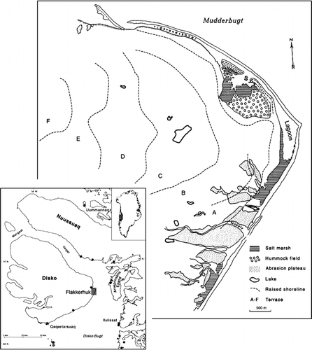
FIGURE 2. Mean sea-level changes in the Mudderbugt region during Holocene. The polynomial fit (2 × 10−6 x 2 − 0.0112x + 9.7639, R 2 = 0.99) used in the present study represents dated sediment (solid squares) from eight isolated basins on Arveprinsen Ejland (CitationLong et al., 1999) while open dots represent dated shells and other organic matter from the region (CitationRasch, 1997). Locations are shown with filled circles in
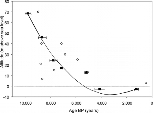
FIGURE 3. Concentration profiles of SOC at A: contrasting vegetation types on terrace B, and B: Cassiope heath sites at two different terraces and C: marsh sites representing a gradient from D1 to D3
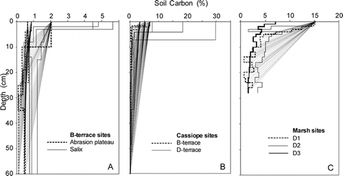
FIGURE 4. Total stocks of SOC to a depth of 60 cm at various terraces. Terrace E has not been sampled and results from terrace A have not been included due to the findings of coal pieces probably imported from nearby coastal coal outcrops. An exponential fit is shown (0.0244e0.0007x ; R 2 = 0.9913)
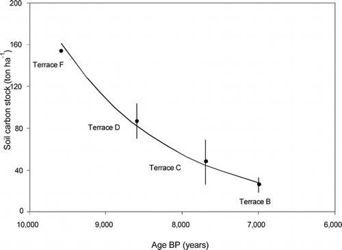
TABLE 1 Characteristics of land cover types on terrace B and the salt marsh at Flakkerhuk, West Greenland. Vegetation characteristics and coverage of land cover types (%) are based on the entire study area
TABLE 2 Sedimentation rates using three methods to evaluate the sedimentation and SOC accumulation at marsh sites near Flakkerhuk, West Greenland
Acknowledgments
We wish to thank our students Jesper Riis Christiansen, Steffen Svinth, and Rikke Baastrup, as well as the laboratory staff at the Institute of Geography for help in the collection and analysis of soil samples and cores. Furthermore we would like to thank Niels Nielsen and Jørgen Nielsen for making this study possible and to journal reviewers for a thorough review with many helpful suggestions. The project was financed by The Arctic Station, the Faculty of Science (University of Copenhagen) and the Danish Natural Science Research Council (21-03-0452).
Related Research Data
References Cited
- Adams, J. M. and H. Faure . 1998. A new estimate of changing carbon storage on land since the last glacial maximum, based on global land ecosystem reconstruction. Global and Planetary Change 16–17:3–24.
- Allen, J. R L. 1990. Salt-marsh growth and stratification: A numerical model with special reference to the Severn estuary, southwest Britain. Marine Geology 95:77–96.
- Billings, W. D. 1987. Carbon balance of Alaskan tundra and taiga ecosystems: past, present and future. Quaternary Science Reviews 6:165–177.
- Bockheim, J. G. , L. R. Everett , K. M. Hinkel , F. E. Nelson , and J. Brown . 1999. Soil organic carbon storage and distribution in Arctic Tundra, Barrow, Alaska. Soil Science Society of America Journal 63:934–940.
- Bockheim, J. G. , K. M. Hinkel , W. R. Eisner , and X. Y. Dai . 2004. Carbon stock and accumulations rates in an age-series of soils in drained thaw-lake basins, Arctic Alaska. Soil Science Society of America Journal 68:697–704.
- Christiansen, H. H. , O. Bennike , J. Böcher , B. Elberling , O. Humlum , and B. H. Jakobsen . 2002. The Zackenberg delta—a Holocene environmental archive in NE Greenland. Journal of Quaternary Sciences 17:145–160.
- Dahl-Jensen, D. , K. Mosegaard , N. Gundestrup , G. D. Clow , S. J. Johnsen , A. W. Hansen , and N. Balling . 1998. Past temperatures directly from the Greenland Ice Sheet. Science 282:268–271.
- Donner, J. and H. Jungner . 1975. Radiocarbon dating of shells from marine Holocene deposits in Disko Bugt area, West Greenland. Boreas 4:25–45.
- Elberling, B. , B. H. Jakobsen , P. Berg , J. Søndergaard , and C. Sigsgaard . 2004. Influence of vegetation, temperature and water content on soil carbon distribution and mineralization in four high Arctic soils. Arctic, Antarctic, and Alpine Research 36:509–519.
- Gilmanov, T. G. and W. C. Oechel . 1995. New estimates of organic matter reserves and net primary productivity of the North American tundra ecosystems. Journal of Biogeography 22:723–741.
- Hobbie, S. E. , J. P. Schimel , S. E. Trumbore , and J. R. Randerson . 2000. Controls over carbon storage and turnover in high-latitude soils. Global Change Biology 6:196–210.
- Humlum, O. 1988. Rock glacier appearance level and rock glacier initiation line altitude: A methodological approach to the study of rock glaciers. Arctic and Alpine Research 20:160–178.
- IPCC, 2001. Climate Change 2001: The Scientific Basis. Contribution of Working Group I to the Third Assessment. Report of the Intergovernmental Panel on Climate Change. Houghton, J. T., Ding, Y., Griggs, D. J., Noguer, M., van der Linden, P. J., Dai, X., Maskell, K., and Johnson, C. A. (eds.). Cambridge: Cambridge University Press. 881 pp.
- Jones, M. H. , J. T. Fahnestock , P. D. Stahl , and J. M. Welker . 2000. A note on summer CO2 flux, soil organic matter, and microbial biomass from different high Arctic ecosystem types in Northwestern Greenland. Arctic, Antarctic, and Alpine Research 32:104–106.
- Kunzendorf, H. , K-C. Emeis , and C. Christiansen . 1998. Sedimentation in the Central Baltic Sea as viewed by non-destructive Pb-210-dating. Danish Journal of Geography 98:1–9.
- Long, A. J. , D. H. Roberts , and M. R. Wright . 1999. Isolation Basin stratigraphy and Holocene relative sea-level change on Arveprinsen Ejland, Disko Bugt, West Greenland. Journal of Quaternary Science 14:323–345.
- Lundqvist, D. P. , D. L. Jansen , C. Christiansen , A. Jensen , T. Balstrøm , and H. Kunzendorf . 2003. 210Pb based deposition rates in the North Sea–Baltic Sea transition—A summary. Danish Journal of Geography 103:99–109.
- Maxwell, B. 1997. Recent climate patterns in the Arctic. In Oechel, W. C., Callaghan, T., Gilmanov, T., Holten, J. I., Maxwell, B., Molau, U., Sveinbjörnsson, B. (eds.), Global Change and Arctic Terrestrial Ecosystems. New York: Springer, 21–46.
- Michaelson, G. J. , C. L. Ping , and J. M. Kimble . 1996. Carbon storage and distribution in tundra soils of arctic Alaska, U.S.A. Arctic and Alpine Research 28:414–424.
- Nielsen, N. 1969. Morphological studies on the eastern coast of Disko, West Greenland. Danish Journal of Geography 68:1–35.
- Nielsen, N. , O. Humlum , and B. U. Hansen . 2002. Meteorological Observations in 2001 at the Arctic Station, Qeqertarsuaq (69°15′N), Central West Greenland. Danish Journal of Geography 102:103–105.
- Oechel, W. C. and W. D. Billings . 1992. Effects of global change on the carbon balance of arctic plants and ecosystems. In Chapin, F. S., III, et al. (eds.), Arctic Ecosystems in a Changing Climate: An Ecophysiological Perspective. San Diego: Academic Press, 139–168.
- Oechel, W. C. , S. J. Hastings , G. L. Vourlitis , M. Jenkins , G. Riechers , and N. Grulke . 1993. Recent change of Arctic tundra ecosystems from a net carbon dioxide sink to a source. Nature 361:520–523.
- Post, W. M. , W. R. Emanual , P. J. Zinke , and A. G. Stangenberger . 1982. Soil carbon pools and world life zones. Nature 298:156–159.
- Rasch, M. 1997. A compilation of radiocarbon dates from Disko Bugt, Central West Greenland. Danish Journal of Geography 97:143–151.
- Rasch, M. and N. Nielsen . 1995. Coastal morpho-stratigraphy and Holocene relative sea level changes at Taupaat, southeastern Disko Island, central West Greenland. Polar Research 14:277–289.
- Søgaard, H. and C. Nordstrøm . 1999. Carbon dioxide exchange in a high-arctic fen estimated by eddy covariance measurements and modelling. Global Change Biology 5:547–562.
- Vourlitis, G. L. and W. C. Oechel . 1999. Eddy covariance measurements of CO2 and energy fluxes of an Alaskan tussock tundra ecosystem. Ecology 80:686–701.
- White, D. M. , D. S. Garland , C. L. Ping , and G. Michaelson . 2004. Characterizing soil organic matter quality in arctic soil by cover type and depth. Cold Regions Science and Technology 38:63–73.