ABSTRACT
The study area spans the 15-km-wide ecotone between coastal tundra and open subarctic forest near Churchill, Manitoba, Canada. Study sites include Black Spruce Wetland, White Spruce Forest, Burned Forest, Forest-tundra Tree Island, and Tundra. These ecosystems are representative of ones that dominate the circumpolar north. Mid-winter snowpack characteristics were measured during 2002, 2003, and 2004, including depth, density, and snow water equivalent. These studies reveal differences induced by changing vegetation characteristics and associated microclimates. Despite the dramatic differences in canopy, the post-fire forest snowpack differed little from that of the unburned forests. Interannual variations were much less than intersite variations in most snowpack characteristics. These studies are intended to be repeated annually in order to establish a longitudinal study of snowpack variation across the Arctic treeline during a period of predicted dramatic change in climate.
Introduction
Characteristics of the snowpack can influence physical (e.g., meltwater production, heat flow) and biological (e.g., plant phenology, invertebrate populations) ecosystem characteristics. For example, snowpack internal characteristics can affect meltwater flow (CitationMarsh and Woo, 1984) and heat flux from the soil (CitationSturm et al., 1997). Snowpack duration can impinge on primary producers such that species distribution, production, and nutrient cycling are affected (CitationBillings and Bliss, 1959; CitationMiller, 1982). Snowpack characteristics must be considered if we are to improve our understanding of how affected ecosystems function since many physical and ecological processes are influenced by snow.
A significant problem with the study of snowpacks is that they can be extremely dynamic—temporally and spatially. Whether it is due to a gentle snowfall or a blizzard, characteristics such as depth and density can change in a matter of hours. Spatial variability occurs within the snowpack where layers can be defined based on differing characteristics (e.g., density, water equivalent, conductivity). Spatial variability also occurs horizontally across the landscape, even at microscale dimensions (e.g., from drift crest to trough, from intercanopy opening to beneath a tree). Thus, if one wants to compare snowpack among sites in a region, it is essential to conduct the survey over the shortest time possible to avoid temporal variation and have high sample sizes to account for internal and horizontal variation.
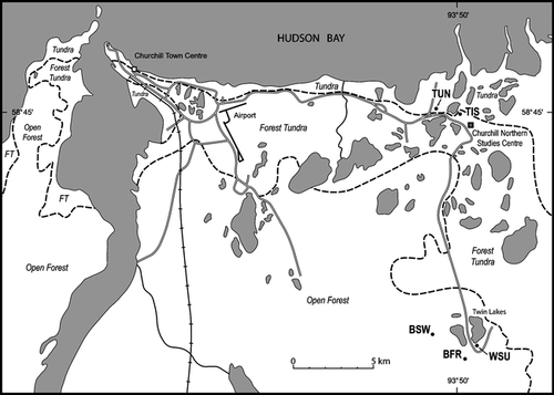
The Arctic treeline transects the study area to separate tundra near the Hudson Bay coast from inland Subarctic forest (). The transitional forest-tundra zone forms a relatively narrow, 10-km-wide ecotone. Vegetation composition, structure, and environmental relations in these three zones can be considered typical of a much greater geographical zone that encompasses large areas of the circumpolar north.
Figure 1 The long-term environmental monitoring sites extended from forested and burned sites 15 km inland from the coast. Biomes separated by dotted lines. Coastal locations were dominated by tundra. Sites sampled: TUN, Tundra; TIS, Forest-Tundra Tree Island; WSU, White Spruce Upland Forest; BSW, Black Spruce Wetland; and BFR, Burned Forest (spruce).
In the Churchill area, differences in vegetation architecture, which affect wind characteristics, cause variations in snowpack characteristics (CitationRouse, 1982; CitationScott et al., 1993). Snow can be redistributed by wind, which in turn is also affected by vegetation characteristics (CitationKind, 1981; CitationTimoney et al., 1992; CitationSturm et al., 2001b). In general, low plant stature leads to a thin snowpack that is prone to wind erosion and redistribution (CitationPomeroy and Gray, 1995; CitationPomeroy et al., 1995). Conversely, within a taller plant cover, where the snow falls through the canopy to the ground, there will be little chance of erosion and redistribution by wind (CitationSturm, 1992; CitationPomeroy and Gray, 1995; CitationWoo and Steer, 1996).
Abrupt changes in plant cover characteristics can have a profound impact on the snowpack. An opening in a forest can have considerably deeper snowpack than the adjacent forest (CitationNeiderhof and Dunford, 1942; CitationPomeroy and Gray, 1995; CitationMurray and Buttle, 2003). However, if the clearing is linear or large enough to be affected by the prevailing wind or storm winds, then the snowpack can be thinner with lower snow water equivalent (SWE) (CitationGary, 1974; CitationKershaw, 1991). In areas where abrupt changes in vegetation characteristics occur from open tundra to a tree island in the forest-tundra, there can be deep accumulations of snow (CitationTimoney et al., 1992). Where graminoid tundra grades into shrub tundra and were complex topography also affects wind redistribution of snow, it is clear that shrubs and depressions can trap significantly greater snowpacks than the winter snowfall (CitationSturm et al., 2001a; CitationEssery and Pomeroy, 2004; CitationHirashima et al., 2004).
In 1999 a long-term study (CitationScott and Kershaw, 2002) was initiated to monitor the environmental responses to climate change in the Churchill region. By 2002, five additional long-term environmental monitoring sites (LTEMS) had been added to the original five, and five reclamation research sites were also under study. As part of the larger research project, snowpack measurements were initiated to establish a longitudinal study to assess the role of vegetation in determining the characteristics of the snowpack. This would enable interannual comparisons to assess whether shifts are occurring in the snowpack characteristics within each of the vegetation types. These data were also intended to provide a baseline against which future changes could be compared. Results of the first three years of these long-term investigations will be presented for the natural ecosystems that have been under study the longest.
Vegetation characteristics vary from open (<20% canopy closure) upland and lowland forests to treeless tundra. Other vegetation types that were included in the sampling campaign were a burned forest and a tree island in the forest-tundra ecotone. Thus data from five ecosystem types, common in the Hudson Bay Lowland, are presented here: Black Spruce Wetland, White Spruce Upland, Burned Forest (1997), Forest-Tundra Tree Island, and Tundra ().
Methods
The LTEMS (approximately 1 ha each) were selected to be representative of each of the dominant ecosystems in the region. They have been subjected to year-round studies to assess their responses to predicted climate change. In each of these areas, three to six groups of two to four people conducted the snowpack sampling. Field data collection occurred over an eight-day period in mid-February of 2002, 2003, and 2004, within a 50- to 75-m radius of the center of the LTEMS. Sampling was based on snow pits, snow cores, and ram penetrometer measurements (CitationMcClung and Schaerer, 1993). Snow coring was conducted with Adirondack snow samplers; however, in 2002 one-third of the samples were taken with a Standard Federal snow sampler. Only the snow core data have been analyzed for this paper. No correction was applied to the Adirondack data, but a correction of −4.6% was used for the Federal Standard–derived data (CitationGoodison, 1978). Sample sizes varied among sites and years (). In the second year in the Tundra site, the hard and shallow snowpack was not always cored; rather, a known volume was taken by using a snow spatula to remove the sample for weighing. At least five of the field party were previously trained and experienced with the sampling procedures, and two were present for all sampling campaigns. All members of the field party were provided with training prior to sampling, and the authors provided quality checking during and after each day of sampling.
Table 1 Sample sizes and canopy characteristics of the long-term environmental monitoring sites, Churchill, Canada.
Weight of the snow was taken and combined with depth to calculate density. SWE was calculated using Pomeroy and Gray's formula for shallow snow (CitationPomeroy and Gray, 1995).
The heat transfer coefficient (HTC) was derived to provide an integrated value to reflect the influence of depth and density on the thermal properties of the snowpack (CitationKershaw, 1991; CitationKershaw, 2001). These parameters are key to evaluating snowpack heat conductance (CitationSturm et al., 1997). For example, it is possible that a thick, high-density snowpack has similar heat conductance characteristics to a thin, low density snowpack; the HTC provides a means for comparing the thermal properties of these different snowpacks. Snowpack thermal conductivity estimates have been improved by CitationSturm et al. (1997) with a more accurate method, using quadratic or logarithmic equations to estimate how thermal conductivity changes with density; logarithmic equations are best suited to low-density snow. Since density varied greatly across the LTEMS plots, it was decided the HTC would best provide a common method for comparison.
Statistical analysis was conducted using the SigmaStat 3.0 program (CitationSPSS, 2003). None of the data were normally distributed (P < 0.001), so a Kruskal-Wallis one way analysis of variance on ranks was conducted (P < 0.001). To isolate the group or groups that differ from the others, Dunn's pairwise multiple comparison procedure was used to assess significant differences (P < 0.05).
Results
Sample sizes varied among years at the five sites (). In 2002, 350 cores were taken, 440 in 2003, and 594 in 2004. The Forest-Tundra Tree Island site was not selected until August 2003, so only data from 2004 were available. The Forest-Tundra Tree Island site was only included for comparison purposes in this analysis.
Snowpack Depth
Over the three years of sampling, mean snowpack depth varied from a maximum mean of 73.6 cm in the Black Spruce Wetland to 8.1 cm on the Tundra (). The exception to this was the Forest-Tundra Tree Island where only one year of data were available and where the mean depth of 128.4 cm was nearly double that of the deepest snowpack at the other sites (). There were no significant differences among years within the LTEMS.
Figure 2 Within-site snowpack depth was similar over the three years but differed among sites. Arithmetic mean with error bar cap at one standard deviation and tick for the median. Tundra and Tree Island (Forest-Tundra Tree Island), White Spruce Forest (upland), and Burned Forest (upland). Different letters indicate significant differences (p < 0.001).
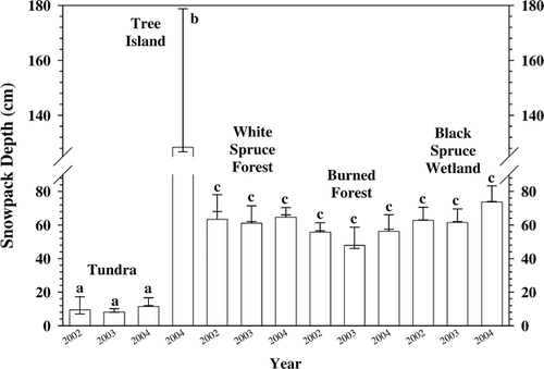
Variability, as suggested by the standard deviation value, of depth at all sites was generally small (). However, on the Tundra this small absolute value could mean a doubling of the depth of snow on the ground over a short distance. The same value for the deeper snowpacks in the forested and burned sites reflected only minor variation in depth. Snowpack depth varied insignificantly between the upland and lowland forested sites (). Even after wildfire, the depth of snow was similar.
Snowpack Density
The mean snowpack density was lowest in forested sites, ranging from 168 kg m−3 to 200 kg m−3 (). The Tundra had a mean snowpack density as high as 336 kg−3 in 2002, which was significantly higher than the forests. However, after 2002 there were no significant differences between Tundra and the forested sites including the Burned Forest ().
Figure 3 The Tundra site had the greatest within-site variation in snowpack density, and it was significantly higher in the first year. The forest sites and the burned forest had similar snowpack density and they were similar to the tundra in the last two years. Arithmetic mean with error bar cap at one standard deviation and tick for the median value. Different letters indicate significant differences (p < 0.001).
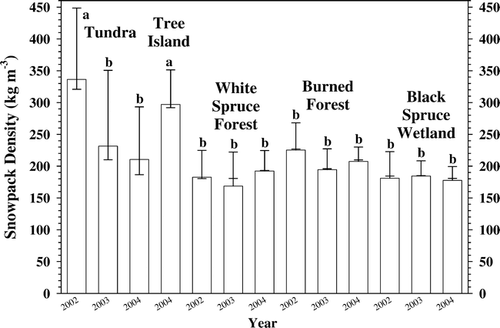
Among years at a site, there was seldom any difference in mean snowpack density (). The only significant difference among years was found on the Tundra in the first year when the values were similar to the 2004 Tree Island density.
Within-site variation was greatest on the Tundra (). The forested and burned sites had a low variation in density within the sites.
Snowpack Swe
The maximum mean SWE was 424 mm in the Forest-Tundra Tree Island which was three times the next highest value of 138 mm in the Burned Forest (). The lowest SWE was on the Tundra site where in 2002 there was only 19 mm water equivalent. SWE values were similar among the sampling years at all sites. All the forested sites and the burn had similar values both among sites and years.
Figure 4 Within-site variation of snow water equivalent (SWE) was greatest at Forest-Tundra Tree Island. The Tundra values were significantly less than all other sites and the forested and burned sites were similar. Between-year variations were not significant. Arithmetic mean with error bar cap at one standard deviation and tick for the median value. Different letters indicate significant differences (p < 0.001).
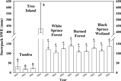
The greatest variation in SWE was in the Forest-Tundra Tree Island, while the least variable was on the Tundra (). The within-site variability in the forested and burned sites was consistent among years.
Snowpack HTC
The potential ability to conduct heat as assessed by the HTC indicates that the snowpack on the wind-swept tundra would offer comparatively little resistance to heat loss (, ). In contrast, the forest stand snowpacks would have at least 10 times greater resistance to heat loss.
Figure 5 Heat transfer coefficients were at least an order of magnitude higher on the Tundra than at all other sites. Arithmetic mean with error bar cap at one standard deviation and tick for the median value. Different letters indicate significant differences (p < 0.001).
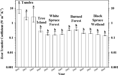
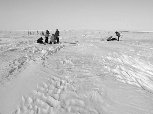
Figure 6 The tundra snowpack was thin to discontinuous with scour and drift throughout the site. Reworking of the snowpack by wind was evident in the zastrugi that was common on the site. Consequently, snowpack characteristics were spatially and internally variable.
The sites with trees or burned snags and shrubs were similar in their heat loss potential. They ranged from 0.207 to 0.348 W m−2 K−1 for the burned forest and 0.14 to 0.196 W m−2 K−1 for the two forest types; however, the standard deviation made the differences insignificant (). Not only were there no significant differences, but the within-site variation was small. Despite dramatic differences in depth between the Forest-Tundra Tree Island and the forested and burned sites there was no difference in the potential to lose heat—it was low.
Discussion
Snowpack Depth
A lack of difference in snowpack depth among years suggests that the prevailing climate conditions were similar among the years for snowfall, wind speed, and wind direction. The increased depth of snow in the Black Spruce Wetland for the third year was probably due to random sampling of more inter-hummock sites than hummock tops. The Black Spruce Wetland was the only site where variable microtopography played an important role in snowpack depth; hummock tops had a thinner snowpack.
Sampling in the Forest-Tundra Tree Island was stratified by position in the tree island for sites on the leading and leeward edges, sides, and center. Thus, the variation in depth was great because of the presence or absence of drifts. In comparison, on the wind-swept Tundra, the drifts were shallow with much shallower snowpack overall, as reflected in the lower standard deviation ().
In general, the low variability within sites and among years attests to the appropriateness of the site selection since a high variation would reflect greater internal heterogeneity of site characteristics that would affect the snowpack. The low standard deviation confirms that the site was uniform and thus representative of the site type it was chosen to typify.
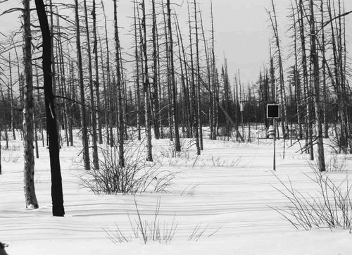
The burned forest was subjected to a wildfire in June 1997. The wildfire killed all above-ground portions of the plants and in some areas burned into the peaty surface layer of the soil. Thus, the site had been recovering for five growing seasons when first sampled in February 2002. At that time the shrubs had resprouted to the extent that they were protecting the snowpack from wind erosion at least until they were incorporated within the snowpack ().
Figure 7 A wildfire killed all above-ground portions of plants in the Burned Forest in 1997. Resprouting of shrubs has contributed to the lack of wind scour with the result that the snowpack characteristics were similar to the unburned White Spruce (upland) and Black Spruce Wetland forests.
Snowpack Density
The most within-site variation in snowpack density was found in the Tundra and Forest-Tundra Tree Island sites (). A variable snowpack reflects the influence of wind where drifts can be much denser than intervening scour zones, and this difference can be expressed over distances of a few decimeters (). Representative sampling in these areas consequently included a range of snow densities due to the predominance of drifts.
The small amount of variation in density within the forested and burned sites was a result of variation in canopy influences. With an open canopy, random sampling can result in some sites falling beneath a tree while others can be in openings between trees. Tree leaves and boughs can intercept snow (CitationPruitt, 1958) and later unload it when it falls mainly around the drip line of the canopy (CitationPomeroy and Gray, 1995). Thus, density can vary within a forested site where drifting is not a factor; however, the amount is much less than in sites such as the Tundra or Forest-Tundra Tree Island where wind can redistribute snow.
Snowpack Swe
SWE is an integrated measure of the snowpack depth and density. It is noteworthy that the forested sites, including the Burned Forest, had similar values, which suggest that stand characteristics have a great influence on SWE. Live trees, standing tree snags, and resprouting erect shrubs appear to have a dominating influence on the evolution of the snowpack. The wildfire occurred in 1997; the first snow sampling was after the fifth growing season by which time stand characteristics had evolved to the point that their influence on the snowpack was comparable to the impact of the trees in the unburned forests.
On the open tundra the lack of erect plants resulted in unimpeded wind with unimpaired ability to erode and transport snow. Consequently, drift processes dominated the Tundra site, while in the Forest-Tundra Tree Island the abrupt change in surface roughness caused accumulation to 18 times the mean SWE on the adjacent tundra.
The sampling sites in the forested and burn areas were all stand-interior locations, intended to characterize these ecosystem types. Standard deviation was very consistent (varied from 23 to 43) among all these sites, which confirms that they are subject to similar conditions and that there is little microsite variation due to factors such as wind, canopy interception, and ground microtopography.
During the spring melt period the Tundra becomes snow-free first and dries much sooner than the forested and burned forest sites. The Forest-Tundra Tree Island with its 422 mm SWE is snow-free last. It has the potential to generate much greater runoff over a longer time period than the other sites. Many factors can affect snowmelt and meltwater generation in northern environments (CitationWoo and Marsh, 2005), but SWE is probably the most important consideration since it will dictate the amount and will directly affect the duration of snowmelt.
Snowpack HTC
Characteristics of depth and density are the core of the calculation of the snowpack's potential to conduct heat. The wind-swept Tundra with thin, high-density snow would offer little resistance to winter heat loss. However, the thicker, lower-density snow of the forests and the burn area would offer better insulation and retention of heat gained during the thaw season.
The similarity in potential heat conduction between the Forest-Tundra Tree Island and the forested and burned forest sites was revealing. This similarity occurred despite dramatic differences in depth of the snowpack (). To properly assess the potential to conduct heat energy from the soil, the density of the snow must also be considered. The high density of the Forest-Tundra Tree Island, when combined with the depth, resulted in HTC values similar to the much shallower but lower density snowpacks in the forested and burned sites.
Conclusions
Over three years, interannual mid-winter differences in snowpack depth, density, SWE, and HTC were rare. Only on the Tundra was there any significant difference among years and then only in the case of density during one year.
Between-site differences in mid-winter snowpack characteristics were only significant where differences in plant cover existed. Upland and lowland forest snowpacks had similar depth, density, SWE, and HTC over all three years of sampling. Even after wildfire the burned forest, which was a white spruce stand, had sufficient resprouting of shrubs and retention of snags to have snowpack similar to the unburned forests. Plant height and density in the Subarctic have greater influence on the snowpack than plant species or whether the individual is alive or a fire-killed snag (assuming shrub post-wildfire resprouting). It is structure and architecture of the forest in these open-canopied stands that have the greatest influence on snowpack characteristics.
In the forests and burned forest, the lack of within-site variability suggests that drifting snow is not common. The surface roughness and resistance to wind induced by the plant cover characteristics reduced drift action. Considering the differences in stand characteristics between the upland and lowland forests and the burn, it is noteworthy that there are few differences in snowpack characteristics.
In contrast with the forested and burned sites, the wind-swept tundra had highly variable snowpack density and heat loss potential. The wind kept the depth relatively constant, but since much of the snow was reworked with each successive blizzard, the density varied with respect to drift location. Drift crests offered the most resistance to heat loss, but scour zones did not. The tundra snowpack was spatially the most highly variable in the study area.
The characteristics of vegetation architecture in forest stands produce relatively uniform and similar snowpacks over a broad range of tree heights and stem densities. Snowpack characteristics affect their ability to insulate the ground against heat loss and this will affect the temperature characteristics of the soil, permafrost, and subnivean environment.
These studies are part of a long-term research project to assess the impacts of climate change on snowpack characteristics in the future. The snowpack studies are combined with continuous monitoring of microclimate, which will provide details of snowpack depth, wind, and temperature characteristics at these same sites.
Acknowledgments
The staff at the Churchill Northern Studies Centre was very cooperative and provided invaluable assistance during these studies. Several University of Alberta students and numerous Earthwatch volunteers collected the data during physically challenging conditions in the research area. These sub-zero heroes deserve much credit for persevering under severe and adverse weather conditions. The Natural Sciences and Engineering Research Council provided a grant to the senior author that partially covered the cost of these studies. Finally, this project is continuing in association with Earthwatch Institute, Maynard, Massachusetts, and more detailed and long-term studies are planned in cooperation with participants in their program.
Related Research Data
References Cited
- Billings, W. D. and L. C. Bliss . 1959. An alpine snowbank environment and its effects on vegetation, plant development, and productivity. Ecology 40:388–397.
- Essery, R. and J. Pomeroy . 2004. Vegetation and topographic control of wind-blown snow distributions in distributed and aggregated simulations for an Arctic tundra basin. Journal of Hydrometeorology 5:735–744.
- Gary, H. L. 1974. Snow accumulation and snowmelt as influenced by a small clearing in a lodgepole pine forest. Water Resources Research 10:348–353.
- Goodison, B. E. 1978. Accuracy of snow samplers for measuring shallow snowpacks: an update. In . Proceedings 35th Annual Meeting Eastern Snow Conference Eastern Snow Conference. 36–49.
- Hirashima, H. , T. Ohata , Y. Kodama , H. Yabuki , N. Sato , and A. Georgiadi . 2004. Nonuniform distribution of tundra snow cover in Eastern Siberia. Journal of Hydrometeorology 5:373–389.
- Kershaw, G. P. 1991. The influence of a simulated transport corridor on snowpack characteristics, Fort Norman, N.W.T., Canada. Arctic and Alpine Research 23:31–40.
- Kershaw, G. P. 2001. Snowpack characteristics following wildfire on a simulated transport corridor and adjacent Subarctic forest, Tulita, N.W.T., Canada. Arctic, Antarctic, and Alpine Research 33:131–139.
- Kind, R. J. 1981. Snow drifting. In Gray, D. M. and D. H. Male , editors. eds. Handbook of snow, principles, processes, management and use Toronto Pergamon Press. 338–359.
- Marsh, P. and M-K. Woo . 1984. Wetting front advance and freezing of meltwater within a snow cover 1. Observations in the Canadian Arctic. Water Resources Research 20:1853–1864.
- McClung, D. and P. Schaerer . 1993. The avalanche handbook Seattle The Mountaineers. 271.
- Miller, P. C. 1982. Environmental and vegetational variation across a snow accumulation area in montane tundra in central Alaska. Holarctic Ecology 5:85–98.
- Murray, C. D. and J. M. Buttle . 2003. Impacts of clearcut harvesting on snow accumulation and melt in a northern hardwood forest. Journal of Hydrology 271:197–212.
- Neiderhof, C. H. and E. G. Dunford . 1942. The effects of openings in a young lodgepole pine forest on the storage and melting of snow. Journal of Forestry 40:802–804.
- Pomeroy, J. W. and D. M. Gray . 1995. Snowcover Accumulation, Relocation and Management Saskatoon National Hydrology Research Institute Science. NHRI Report No. 7. 134.
- Pomeroy, J. W. , P. Marsh , H. G. Jones , and T. D. Davies . 1995. Spatial distribution of snow chemical load at the tundra-taiga transition. In Tonnessen, K. A. , M. W. Williams , and M. Tranter , editors. eds. Biogeochemistry of Seasonally Snow-Covered Catchments IAHS Publication 228. Saskatoon International Association of Hydrological Sciences. 191–206.
- Pruitt, W. O. J. 1958. Qali, a taiga snow formation of ecological importance. Ecology 39:169–172.
- Rouse, W. R. 1982. Microclimate of low arctic tundra and forest at Churchill, Manitoba. In French, H. M. , editor. ed. Proceedings of the Fourth Canadian Permafrost Conference Ottawa National Research Council of Canada. 68–80.
- Scott, P. A. , R. I. C. Hansell , and W. R. Erickson . 1993. Influences of wind and snow on northern tree-line environments at Churchill, Manitoba, Canada. Arctic 46:316–323.
- Scott, P. A. and G. P. Kershaw . 2002. 1999, 2000, 2001, and winter 2002 raw data from the long-term ecological research program. Churchill Churchill Northern Studies Centre.
- SPSS 2003. SigmaStat 3.0. Chicago SPSS Inc.
- Sturm, M. 1992. Snow distribution and heat flow in the taiga. Arctic and Alpine Research 24:145–152.
- Sturm, M. , J. Holmgren , M. König , and K. Morris . 1997. The thermal conductivity of seasonal snow. Journal of Glaciology 43:26–41.
- Sturm, M. , J. P. McFadden , G. E. Liston , F. S. Chapin III , C. H. Racine , and J. Holmgren . 2001a. Snow-shrub interactions in Arctic tundra: A hypothesis with climatic implications. Journal of Climate 14:336–344.
- Sturm, M. , C. Racine , and K. Tape . 2001b. Increasing shrub abundance in the Arctic. Nature 411:546–547.
- Timoney, K. , G. P. Kershaw , and D. Olesen . 1992. Late winter snow-landscape relationships in the Subarctic near Hoarfrost River, Great Slave Lake, Northwest Territories, Canada. Water Resources Research 28:1991–1998.
- Woo, M-K. and P. Marsh . 2005. Snow, frozen soils and permafrost hydrology in Canada, 1999–2002. Hydrological Processes 19:215–229.
- Woo, M-K. and P. Steer . 1996. Monte Carlo simulation of snow depth in a forest. Water Resources Research 22:1710–1716.