Abstract
There have been only a few truly integrated quantitative studies on sediment budgets and relief development in cold environments. For a combined quantitative investigation of the relevant denudative slope processes and stream work in the 7 km2 catchment Hrafndalur, situated in a rhyolite area in the northern part of the Icelandic Eastern Fjords region (Austfirðir), information was collected on the absolute and relative importance of the different denudative processes. Integration of the six-year monitoring program with the analysis of Holocene storage elements using geophysical techniques allows estimates on Holocene process intensities in addition to the measured present-day sedimentary transfers. With respect to mass transfers, fluvial suspended sediment plus bed-load transport is most relevant and is followed by fluvial solute transport, rock and boulder falls, chemical slope denudation, mechanical fluvial slope denudation (slope wash), creep processes, avalanches, debris flows, translational slides, and deflation. Due to comparably high mechanical weathering and sedimentary transfer rates, postglacial modification of the Pleistocene glacially formed landscape is clearly more advanced than in the extended basalt areas of Austfirðir. Postglacial relief development is characterized by a valley widening due to the active retreat of rock walls and the formation of extended talus cones coupled with channel systems.
Introduction
Sediment Budget Studies In Cold Environments:
There have been only few truly integrated quantitative studies of sediment budgets and relief development in cold environments (e.g. CitationJäckli, 1957; CitationRapp, 1960; CitationCaine, 1974, Citation2004; CitationCaine and Swanson, 1989; CitationBarsch, 1981; CitationWarburton, 1993, Citation2006; CitationBecht, 1995; CitationBeylich, 2000, Citation2002, Citation2008; CitationBeylich et al., 2005; CitationBeylich and Warburton, 2007; CitationBeylich et al., in review; CitationSchrott et al., 2002, Citation2003; CitationOtto and Dikau, 2004; CitationSlaymaker, 2008; CitationHansen et al., in press). Projected climate change will cause major changes in Earth surface systems with the most dramatic changes being expected to occur in subpolar and polar environments. Geomorphic processes that operate at the Earth's surface and transfer sediments and change landforms are highly dependent on climate, vegetation cover, and human impact and will be significantly affected by climate change (e.g. CitationRapp, 1985; CitationEvans and Clague, 1994; CitationHaeberli and Beniston, 1998; CitationLamoureux, 1999; CitationLamoureux et al., 2007; CitationSlaymaker et al., 2003; CitationOrwin and Smart, 2004; CitationBeylich et al., 2006b, Citation2008; CitationBeylich and Warburton, 2007; CitationCockburn and Lamoureux, 2007; CitationSlaymaker, 2008).
A better knowledge of rates of sedimentary transfer processes operating in present-day climates is needed to determine the consequences of predicted climate change. It is necessary to collect and compare data on both contemporary sedimentary fluxes and on storage elements from a wide range of different high-latitude and high-altitude cold environments and to apply more standardized methods for research on sediment fluxes and relationships between climate and sedimentary transfer processes (CitationBeylich et al., 2006a, Citation2008; CitationBeylich and Warburton, 2007; CitationLamoureux et al., 2007). The aims of this study are to: (i) analyze the rates and the spatio-temporal variability of denudative processes and sedimentary transfers within the Hrafndalur catchment; (ii) investigate the absolute and the relative importance of the different denudative processes; (iii) quantify the sediment budget for this catchment; and (iv) analyze trends of relief development in this subarctic oceanic environment.
Study Area
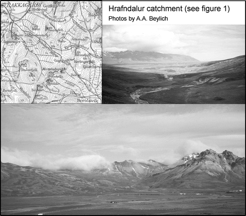
The Hrafndalur catchment (7 km2, 6–731 m a.s.l.; 65°28′N, 13°42′W) is situated in the northern part of the Easter Fjords region (Austfirðir) in eastern Iceland ( and ). The climate is subarctic oceanic, with a mean annual precipitation of 1719 mm yr−1 and mean annual air temperature of 3.6 °C. Runoff occurs year-round with the highest discharges during spring snowmelt (normally April–June), winter thaw events, and especially during extreme rainfall events which are normally most frequent in fall (September–November) (CitationBeylich, 1999, Citation2000, Citation2003, Citationaccepted). Runoff can cease during dry periods in summer and frost spells in winter (). The steep and glacially sculptured alpine setting contains slopes composed of rock faces and talus cones, and main channels changing between resistance-limited bedrock channels and channel stretches with temporary storage of bed-load material (). The bedrock lithology in Hrafndalur is dominated by rhyolites, while basalt occurs only as smaller intrusions and dikes. Vegetation includes lichens, mosses, meadows, bogs, and dwarf shrubs. Relevant denudative processes are rock and boulder falls, avalanches, debris flows and slides, creep processes, slope wash, chemical denudation, fluvial transport of solutes, suspended sediments and bed load, and deflation. The main storage elements in the valley are extended talus cones. In addition, there is a Holocene valley fill in the lowest part of Hrafndalur. Human impact exists in the form of grazing which has caused a significant disturbance of the vegetation cover in larger parts of the valley () (CitationBeylich, 2007).
Figure 1 Location of the Hrafndalur catchment (Austfirðir, Iceland) and investigation areas, test sites, and instrumentation within the catchment.
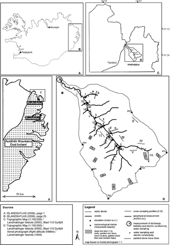
Figure 2 The Hrafndalur catchment in eastern Iceland.
Approach and Methods
This study focuses on quantifying rates of denudative processes, mass transfers, and the sediment budget of a 7 km2 catchment. The process rates and mass transfers have been calculated after a six-year investigation (November 2001–December 2007) carried out in the Hrafndalur catchment, along with geophysical investigations to quantify volumes of sediment storage elements and regolith thicknesses that were performed in the summer of 2005.
Selection of Measuring Sites and Sampling Sites
The Hrafndalur catchment is lithologically mainly composed of rhyolites, with some basalt (CitationBeylich, 2007; CitationBeylich et al., 2007a). The selected measurement sites, profiles, slope test sites, and sampling sites/profiles are shown in . shows the topography, landforms, and geographical setting of the catchment.
The slope test and sampling sites were selected after analysis of the existing aerial photographs of the area and detailed field investigations. It was our aim to analyze subareas with significant differences in (i) steepness and slope form, (ii) aspect to radiation, (iii) snow cover and ground frost duration, and (iv) vegetation cover.
Geophysical Investigations
Geophysical methods are particularly suitable for geomorphologic investigations since the knowledge of structure and composition of the subsurface at different scales is a key parameter for geomorphologic problems. The basic principle for the successful application of geoelectrical methods in geomorphology is based on the varying electric conductivity of minerals, solid bedrock, sediments, air and water, and consequently their varying electrical resistivity. The resistivity of rock, for example, depends on water saturation, chemical properties of pore water, structure of pore volume, and temperature. The large range of resistivity values for most materials is due to varying water content.
Resistivity measurements are made by introducing a direct current into the ground via two electrodes. Resistivity surveys give an image of the subsurface resistivity distribution. Knowing the resistivities of different material types, it is possible to convert the resistivity image into an image of the subsurface consisting of different materials.
For this study the two-dimensional (2D) electrical surveys were performed using the Wenner and Wenner-Schlumberger configurations and an IRIS SYSCAL Junior Switch resistivity meter. In total, 10 selected profiles (profiles a–j in ) were performed in summer 2005. The measured apparent resistivities are used to build up a vertical contoured section showing the lateral and vertical variation of resistivity over the section. The conventional method of plotting the results for the interpretation is the so-called pseudosection, which gives an approximate image of the subsurface resistivity distribution. The measured sets of apparent resistivities were inverted using RES2DINV software. Further details on different array geometries and data processing strategies can be found in CitationReynolds (1997), CitationKneisel (2003, Citation2006), and CitationHauck and Kneisel (2008).
Meteorological Measurements and Snow Sampling
Meteorological data are available from a meteorological station (Desjamyri) located close to the lower part of Hrafndalur and operated by the Icelandic Meteorological Office (Veðurstofa Islands) (). Precipitation has been measured daily since 1998 in accordance with the regulations of Veðurstofa Islands (1.5 m above ground).
Snow cores of the complete vertical snow pack were taken six times during the entire period of investigation (November 2001–December 2007) along selected profiles (see ) using a plastic tube (10 cm diameter). The snow cores were melted in buckets at the field base and the water was filtered with a pressure filter and ash-free filter papers (Munktell quantitative filter papers, OOH) with the goal to quantify Total Dissolved Solids (TDS) and the concentration of mineralogenic particles in the snow cores (see below).
Measurement of Relevant Denudative Slope Processes
A combination of process monitoring and geophysical mapping as well as further field observations and detailed photo documentation were used to analyze relevant denudative slope processes and sedimentary fluxes in Hrafndalur. Eight slope test sites (1–8) within the 7 km2 catchment were selected after studying aerial photographs and previous fieldwork. The slope test sites differ with respect to slope form, aspect, elevation, and local geographical setting and were selected to cover the range of different settings found within Hrafndalur. Six slope test sites (slope test sites 2 + 4–8) include an active rock face, a talus cone, as well as areas with avalanches, debris flows, slow mass movements, and slope wash. At two slope test sites (slope test sites 1 + 3) there is no rock face left due to Holocene rock wall back-wearing and talus cone formation.
All slope test sites were instrumented in November 2001 to monitor rock and boulder falls (slope test sites 2 + 4–8) as well as creep processes and slope wash (slope test sites 1–8). Additionally, avalanches, debris flows, and slides were studied at selected and other adequate sites within the catchment ().
Rock Falls and Boulder Falls
Rock falls and boulder falls were investigated at the six slope test sites with active rock faces (slope test sites 2 + 4–8) by applying a combination of monitoring and detailed photo documentation. At all investigated sites the rock fall and boulder fall activity was locally not influenced by avalanche activity. The denudative importance of avalanches was studied at selected sites within Hrafndalur (see below). At each investigated slope test site an 80 m2 (8 m × 10 m; size of meshes: 1.5 cm) large net was installed with the long axis placed parallel to the face on the talus cone below vertical rock walls (). The nets were efficient in collecting debris produced by mechanical weathering at the rock walls and transferred to the net by primary and secondary rock falls. The collected debris was repeatedly quantified by weighing it with a portable field balance (kg m−2, kg m−2 yr−1). Rock wall retreat rate (mm yr−1) was calculated by estimating the surface area of the defined and debris-supplying rock face and relating it to the mass of debris accumulated below the rock face, using an estimated mean rock density of 2.2 (CitationBeylich et al., 2007a). The mass of accumulated debris smaller than ca. 1.0 cm in diameter was quantified with painted rock faces. At each slope test site with debris-supplying rock face two squares of 1 m2 were painted in November 2001 and repainted in each following year. Fine debris accumulated below the painted squares could be identified on the debris and the total mass of fine debris was quantified by weighing the debris with a portable field balance. The total mass of fine debris was then related to the clearly defined source area of 1 m2 rock surface.
Boulder falls were investigated at the six slope test sites with material supplying rock faces by detecting, mapping, counting, and measuring fresh boulders accumulated below the boulder-supplying rock walls. For detecting and mapping of fresh boulder falls, detailed photo documentation was carried out each summer by taking photographs. The boulder size measurements (a-, b-, and c-axes) were carried out in the field.
Three geoelectrical profiles (see profiles f–h in ) were also performed on talus cones in order to infer the scree thicknesses.
Avalanches
Avalanches occur during the early summer season (normally during April–June) and during winter thaw events. In Hrafndalur, avalanches are restricted to the steep NE-facing valley slope ( and ). Avalanches triggered at this valley side cause rock and boulder falls at the extended rock faces of this slope () and transfer both newly released material from rock faces as well as remobilized material from talus cones down-slope. Especially in the upper parts of the catchment, avalanches transfer material from slopes into main channels.
Total annual accumulations (t yr−1) of inorganic material (including fine material, debris, and boulders) by avalanches occurring at the NE-facing valley slope were quantified for the years 2002–2007 by combining a detailed sampling, measuring, and weighing of newly deposited material with an estimation of the entire affected deposition area at the valley slope and a detailed photo documentation of the entire valley slope system. Newly accumulated and dried debris was weighed at defined 1 m2 plots within the accumulation areas of avalanches and fine material was sampled for the quantification of inorganic mass (burning of the material over 12 h at 550 °C in the laboratory). Mapping of the deposition area as well as the detection and mapping of fresh boulder falls were carried out each summer during the six-year investigation period. Boulders were measured in field (a-, b-, c-axes). The mean density of boulders was estimated to be 2.2 t m3. (CitationBeylich et al., 2007a).
Debris Flows And Slides
Debris flows and debris slides were investigated by detailed annual photographic documentation of slopes. Both new and old traces of debris flows and debris slides were mapped. The volumes of transferred material as well as the transport distances were measured in the field. Debris flows are significant for transferring material from slope to main channel systems.
Slope Creep Processes
Slope creep processes were analyzed at the eight different test sites by monitoring movements of painted stone tracer lines and steel rod lines. At each slope test site three stone lines (A, B, C) with 40 painted stones at each line (A1–A40, B1–B40, C1–C40) were installed in November 2001. The stone tracer lines A–C were installed parallel at defined distances from the rock face of slope test sites 2 and 4–8 and from defined stable rock outcrops at slope test sites 1 and 3. The horizontal distance between stones was one meter. Down-slope movements of all painted stones (120 stones per slope test site) were measured each year with a steel tape.
At alternate locations where a painted stone was placed, a steel rod (1.0 cm diameter) was installed vertically 10 cm down into the ground. In total, 60 steel rods (A1–A20, B1–B20, C1–C20) per slope test site were installed. Down-slope movements of all steel rods were measured each year along with the movements of painted stones.
Estimating The Importance of Deflation
The importance of deflation and eolian deposition were estimated by analyzing sediment concentrations in snow cores collected along defined profiles (snow sampling profiles I–VI) within the catchment (see and ) (see above).
Chemical Denudation, Slope Wash, and Fluvial Transport
Chemical denudation was investigated by analyzing water samples collected from small creeks and soil pipes on the slopes ( and ). Solute yields and chemical denudation rates for the Hrafndalur catchment were calculated based on measurements of atmospheric solute inputs to the catchment, runoff, and solute concentrations in the main creek (see below). Water chemistry analyses were performed in the laboratory of the Geological Survey of Norway (NGU) in Trondheim, using ICP-AES (inductively coupled plasma atomic emission spectroscopy) and IC (Dionex Ioncromatograph 120 DX).
Slope wash was studied with Gerlach traps installed at the eight slope test sites within Hrafndalur. In addition, suspended sediment concentrations in small creeks draining the slope systems were analyzed ( and ) (see below). Discharge at the outlet of the catchment was measured by continuous and year-round monitoring of water level using a pressure sensor (GLOBAL WATER) recorded at hourly intervals, in combination with 225 propeller measurements using an Ott-propeller (model C2) at selected water level stages between 2001 and 2007. Daily specific runoff (mm d−1) was calculated by dividing calculated daily discharge by the catchment area (CitationBeylich, 1999). The stable channel cross-sectional profile at the bridge where measurements were taken provided reliable measurements and a strong correlation between water level and discharge (r = 0.92, n = 225).
Fluvial suspended sediment and solute transport were analyzed by combining continuous and year-round monitoring of turbidity and electric conductivity (GLOBAL WATER) with hourly readings with discrete water sampling during the field campaigns (2001–2007). In total 445 water samples were collected at the catchment outlet to calculate the relationship between turbidity and suspended sediment concentration. Vertically integrated water samples were taken with 1000 mL wide-necked polyethylene bottles. The samples were filtered in the field with a pressure filter and ash-free filter papers (Munktell quantitative filter papers). After the field campaigns, the filter papers were burned (550 °C) to analyze the concentrations of minerogenic suspended solids (mg L−1). For the relationship between turbidity and suspended sediment concentration the correlation coefficient of r = 0.89 (n = 445) indicates a high reliability for the calculation of annual suspended sediment yields based on continuous, hourly turbidity measurements.
The estimation of annual solute yields was based on the relationship between electrical conductivity and concentration of total dissolved solids. This relationship was calculated after using a total of 128 water samples. The correlation between measured electric conductivity and analyzed concentration of total dissolved solids of these water samples was strong (r = 0.91, n = 128), and calculation of annual yields of solutes based on continuous hourly measurements of electric conductivity at the catchment outlet appears to be reliable.
The stability of creeks and channel stone pavements as well as the range of bed-load transport was estimated by using painted stone tracer lines at selected creeks and channel stretches (). In addition, fresh accumulations of debris/bed load were analyzed by weighing of debris (portable field balance) and by a detailed measuring of the volumes of fresh deposits. The estimation of annual bed-load transport rates presented in this paper might include larger errors, but the repeated analysis (two to three times per years) of the channel stretches above and below the catchment outlet using photo documentation and the measuring of the volumes of fresh bed-load deposits permits rough estimates. The calculated values for bed-load transport must be included in the annual sediment budget estimations given that bed-load transport plays an important role in Hrafndalur.
In addition to the continuous and year-round monitoring and frequent samplings at the catchment outlet, surface water electric conductivity, corrected to 25 °C, was measured at different locations within Hrafndalur ( and ) using a portable conductivity meter.
Results
Rock Falls and Boulder Falls
Masses of newly accumulated debris (kg m−2) on nets installed below rock faces, corresponding to annual rock wall retreat rates (mm yr−1) and mean annual rock wall retreat rates (mm yr−1) during the study period (2001–2007) at the slope test sites 2 and 4–8 are presented in . Rock fall activity is caused by freeze-thaw cycles including (i) annual cycles, (ii) frost-free days following frost periods of several days duration, as well as (iii) daily freeze-thaw cycles. Most boulder falls are triggered by avalanches. The highest frequency of rock and boulder falls is during spring (April/May). Strong wind gusts and heavy rainfall can also trigger secondary summer rock falls (CitationBeylich, 1999, Citation2003). The mean annual rock wall retreat rates vary between 2.8 mm yr−1 at slope test site 5 and 4.2 mm yr−1 at slope test site 7. The ratio of the largest recorded annual rate and the smallest annual rate is accordingly 1.5. The mean of all six recorded mean annual rock wall retreat rates is 3.6 mm yr−1.
Table 1 Rock falls, boulder falls, and rock wall retreat rates at slope test sites in Hrafndalur (2001–2007).
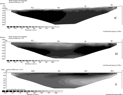
The results of three geoelectrical profiles undertaken on talus cones in the upper part of Hrafndalur are shown in . The images of resistivities against depth show a general decrease in resistivity with depth with a clear contrast between higher resistivities in the upper 15–20 m and higher conductivity beneath a depth of 25 m. The higher resistivities in the upper parts are due to the coarser scree material of the talus cone, while the improved conductivity is due to finer-grained weathered regolith at depth. From the results of the geoelectrical surveys a thickness of the talus cones of 15–20 m can be inferred.
With a mapped surface area of 1.8 km2 for talus cones (see ) a total postglacial volume of rock fall debris of about 31.5 million m3 or ca. 63 million tons can be estimated. This corresponds to a mean annual rock wall retreat rate of ca. 4 mm yr−1 over the last 8000 years (with a given total rock wall surface area of 0.9 km2; see ), which is slightly higher than the measured rate of 3.6 mm yr−1 during the last six years. It has to be considered that a relevant amount of material is transported from talus cones into main channels especially since talus cones were reaching a size where they can feed directly into main channels (see below). Accordingly, the postglacial rate of rock wall retreat can be expected to be slightly higher than 4 mm yr−1. This would also be consistent with the assumption of higher process rates directly after the deglaciation (e.g. CitationBallantyne, 2002).
Avalanches
Annual masses of inorganic material deposited by avalanches (t), mean transport distances (m), and corresponding annual mass transfers (t m) caused by avalanches are provided in . The mean annual mass of deposited inorganic material is 43.7 t, which is composed of boulders, debris, and finer material. The largest annual deposition occurred in 2007 (52 t) and the smallest in 2002 (36 t).
Table 2 Annual mass transfers by avalanches in Hrafndalur (2002–2007).
Debris Flows and Slides
Debris flows and translational slides in Hrafndalur are triggered by heavy rainfall (CitationBeylich, 2003). Annual masses, transport distances, and mass transfers connected to debris flows and translational slides are shown in . For the period 2002–2007 mass transfers by debris flows (3422 t m) are 13 times higher than mass transfers caused by translational slides (263 t m).
Table 3 Annual mass transfers by debris flows and translational slides in Hrafndalur (2002–2007).
Creep Processes
Mean annual movement rates of stone tracer lines as monitored at the eight slope test sites over the six-years investigation period within the Hrafndalur catchment are given in . Movements of stone tracers are mainly caused by (i) avalanches and (ii) hits by rock falls, also reflected in significantly higher mean annual movement rates of entire stone tracer lines at the slope test sites, which are composed of an active rock face and a talus cone (slope test sites 2 and 4–8), compared to the slope test sites without an active rock face (slope test sites 1 and 3). This assumes that both avalanches and rock falls cause a significant redistribution of older material on talus cones, in addition to supplying and accumulating new material. The mean annual movement rates of entire stone tracer lines at slope test sites with avalanche and rock fall activity varied from 19.8 cm yr−1 at slope test site 5 (stone tracer line C) to 33.7 cm yr−1 at slope test site 7 (stone tracer line A). At the two slope test sites without any avalanche and rock fall activity the mean annual movement rates of entire stone tracer lines range from 7.3 cm yr−1 at slope test site 3 (stone tracer line B) to 13.9 cm yr−1 at slope test site 1 (stone tracer line B). In addition to avalanches and rock falls, stone tracer movements are also caused by freeze-thaw events, extreme rainfall events causing saturation overland flow (see below), and by strong wind gusts.
Table 4 Mean annual movement rates of painted stone tracer lines and steel rod lines over six years at eight slope test sites (1–8) in Hrafndalur (2001–2007).
also presents mean annual movement rates of steel rod lines at the eight slope test sites. The movement rates at the slope test sites without sediment delivery from active rock faces (slope test sites 1 and 3) range from 0.9 cm yr−1 at slope test site 1 (steel rod lines B and C) to 1.2 cm yr−1 at slope test site 2 (steel rod line A) and are significantly smaller than at the sites with active rock faces (slope test sites 2 and 4–8) where rates between 2.4 cm yr−1 at slope test sites 4 (steel rod lines B and C) and 8 (steel rod line C) and 3.0 cm yr−1 at slope test site 7 (steel rod line A) were measured. The down-slope movement rates of the steel rod lines clearly depend on the rates of sediment supply from active rock faces situated above the talus cones, which is, in combination with the down-slope movement rates of material, also controlled by the steepness of the talus cones. The higher the delivery rate, the steeper is the resultant slope angle and the larger is the down-slope movement rate of material. All investigated talus cones are free of vegetation, which also indicates the high rates of mechanical weathering at rock faces and connected rock fall activity and delivery of material. The movement of the monitored 10 cm thick surface layer is mainly caused by the annual freeze-thaw cycle with seasonal ground frost reaching depths more than 0.5 m (CitationBeylich, 1999, Citation2003).
Chemical Slope Denudation
Rates of annual atmospheric solute inputs to the catchment, annual solute yields and chemical denudation rates are provided in and . The mean annual atmospheric solute input (2002–2007) in Hrafndalur is 26.0 t km−2 yr−1 (). The mean annual chemical denudation rate is 29.3 t km−2 yr−1 (). The mean annual discharge-weighted TDS values, ranging from 39.7 mg L−1 in 2002 to 42.0 mg L−1 in 2007 show a low inter-annual variability. Accordingly annual yields of solutes are strongly dependent on annual runoff, which varied between 1112 mm yr−1 in 2004 (yield of solutes 46.8 t km−2 yr−1) and 1779 mm yr−1 in 2002 (yield of solutes 70.6 t km−2 yr−1) ().
Table 5 Annual atmospheric solute inputs in Hrafndalur (2002–2007).
Table 6 Annual suspended sediment yields and annual chemical denudation rates in Hrafndalur (2002–2007).
Slope Wash
Mean annual slope wash (2002–2007) ranged from 0.008 kg m−2 (slope test sites 2, 4, 6, and 8) to 0.013 kg m−2 (slope test site 3). Slope wash occurs during snowmelt and during heavy rainfalls causing saturation overland flow.
Suspended sediments are fluvially transferred from the slopes into the main channels via small creeks, and the annual yields of suspended sediments determined for the outlet of Hrafndalur can be used as estimation of the suspended sediment yields at the slope systems in Hrafndalur. Annual yields of suspended sediments vary significantly from 11.4 t km−2 yr−1 in 2004 to 30.6 t km−2 yr−1 in 2002. The mean annual suspended sediment yield for the investigation period (2002–2007) is 18.5 t km−2 yr−1, which is lower than chemical slope denudation rates in the valley (). Most suspended sediment transport from the slopes to the channels occurs during heavy rainfalls, which trigger debris flows and cause saturation overland flow at the slope systems (see below).
Deflation
Concentrations of inorganic solids in snow cores collected along different selected profiles within Hrafndalur ( and ) document that deflation takes place to a certain degree in areas with destroyed, disturbed, or stressed vegetation cover, especially when these areas are exposed in winter due to eolian redistribution of snow. Deflation is significantly increased by needle ice formation in such exposed slope areas (CitationBeylich, 2000, Citation2003). With respect to mass transfers, deflation has only limited importance in Hrafndalur (see ).
Fluvial Transport
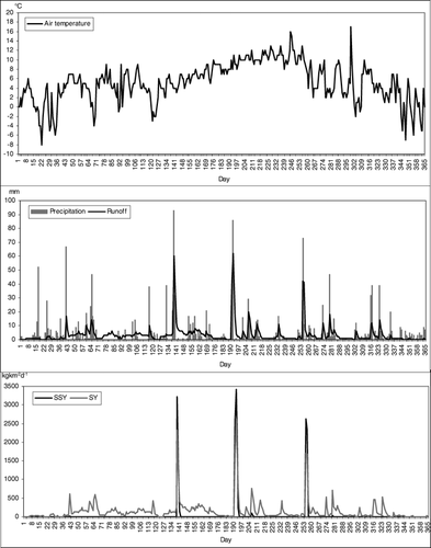
Fluvial solute transport, suspended sediment transport, bed-load transport, as well as yields of solutes and suspended sediments were quantified for the years 2002–2007 at the outlet of the Hrafndalur catchment ( and ). Transport rates and yields are presented in and . shows daily air temperatures, precipitation, runoff, as well as daily suspended sediment yields and solute yields in the year 2003.
Figure 3 Daily air temperatures, precipitation, runoff, and daily suspended sediment yields (SSY) and solute yields (SY) in Hrafndalur (catchment outlet) in 2003.
Based on the investigations carried out between 2002 and 2007 about 78% of annual precipitation contributes to runoff in Hrafndalur. The mean annual discharge-weighted TDS value for the Hrafndalur catchment is 41.3 mg L−1 and the mean annual chemical denudation rate (2002–2007) at the outlet of Hrafndalur is 29.3 t km−2 yr−1 () (see above). Surface water chemistry in Hrafndalur is dominated by Cl−, Na+, Ca2+, Si, SO4 2−, and Mg2+ ().
The mean annual discharge-weighted suspended sediment concentration at the outlet of the catchment is 13.4 mg L−1 and the mean annual yield of suspended sediments is 18.5 t km−2 yr−1 (). The mean annual bed-load transport (2002–2007) is 183 t (). Chemical denudation dominates over the yield of suspended sediments, which makes this rhyolite area different from the extended basalt areas of Austfirðir where yields of suspended sediments are generally higher than chemical denudation rates (CitationBeylich, 1999, Citation2000). Due to high bed-load transport rates, total mechanical denudation (suspended sediment plus bed-load transport) altogether dominates over chemical denudation in Hrafndalur ().
Table 7 Suspended sediment yields during rainfall generated peak runoff and annual bed load transport rates in Hrafndalur (2002–2007).
Table 8 Water chemistry in Austfirðir (Hrafndalur and Austdalur).
Table 9 Annual mass transfers by different denudative processes in Hrafndalur (7 km2), as based on investigations carried out from 2001 until 2007 and annual mass transfers by the different denudative processes in Austdalur (23 km2), as based on investigations carried out from 1996 until 2007.
Fluvial events in subarctic and arctic landscapes are generated by snowmelt, by rainfall, or by combinations of snowmelt and rainfall. Quantitative studies on the importance of snowmelt- and rainfall-generated peak runoff for annual fluvial sediment transport and fluvial denudation rates in cold environments are still rare (CitationClark, 1988; CitationBarsch, 1993; CitationBarsch et al., 1994; CitationGintz and Schmidt, 2000; CitationBeylich, 2000; CitationBeylich and Gintz, 2004; CitationBeylich and Sandberg, 2005). In Hrafndalur runoff peaks occur during snowmelt in spring (normally April–June), during heavy rainfall (especially in fall), and during wintry thaws. A significant increase of suspended sediment concentrations as well as significant bed-load transport were measured at days with runoff over 40 mm d−1, with these runoff peaks being caused by heavy rainfall events (). The annual number of days with daily runoff over 40 mm d−1 varied during 2002–2007 between 4 days in 2004 and 2005 and 8 days in 2002 and 2006 (, ). During the six years of investigation, altogether 80% of the annual suspended sediment yield and almost 90% of the annual bed load were transported during these few days with rainfall-generated daily runoff over 40 mm d−1 (, ). Significantly increased suspended sediment concentrations as well as high bed-load transport rates during these days are connected (i) to debris flows triggered by heavy rainfall and transporting material into main channels and (ii) to slope wash processes. Clearly most sediments transported in the main channels and exported from the Hrafndalur catchment are coming from the slope systems. High mechanical weathering rates in combination with the significant disturbance of the vegetation cover (due to grazing) in larger areas of Hrafndalur are significant factors for the high sediment delivery rates from the slopes during days with heavy rainfall and connected rainfall-generated peak runoff over 40 mm d−1.
Mass Transfers, Sediment Budget, and Trends of Relief Development
Relative Importance of The Different Denudative Processes
On the basis of the process rates calculated for Hrafndalur, the absolute and the relative importance of present-day denudative processes in the entire catchment was estimated by the quantification of the mass transfers caused by the different processes. To allow direct comparison of the different processes, all mass transfers are shown as tonnes × meters per year (t m yr−1), i.e. as the product of the annually transferred mass and the corresponding transport distance (see CitationJäckli, 1957; CitationRapp, 1960; CitationBarsch, 1981; CitationBeylich, 2000, Citation2008). The mass transfers calculated for Hrafndalur are shown in . It is stressed that these mass transfers are based on process studies and monitoring carried out over a six-year period (2002–2007). In computing the mass transfer caused by rock falls and boulder falls, the following assumptions were made: a total debris-supplying rock wall surface of 0.9 km2, a mean annual rock wall retreat rate of 3.6 mm yr−1, an average transport distance of 50 m, and an average rock density of 2.2 (CitationBeylich et al., 2007a). The material transported and deposited by avalanches was presumed to have an average density of 2.0. Calculating the mass transfer caused by creep was led by the following assumptions: an affected surface of 1.8 km2, an average movement rate of 0.022 m yr−1 in a 0.25 m thick layer, and a medium density of 2.0. In contrast to the other denudative processes, chemical denudation affects the total surface of the slope systems. The transport distance of 400 m is about half the medium distance between water divide and main channel.
The transport distance of 1750 m for fluvial solute and suspended sediment transport is about half the distance between the water divide opposite to the catchment outlet and the outlet. The presented estimation of annual mass transfers might include some errors. Anyway, the scale of the calculated mass transfers and the relative importance of the different processes should be correct.
Ranking the different processes according to their annual mass transfers shows that stream work dominates over slope denudation, with fluvial solid transport, including both suspended sediment transport plus bed-load transport, being more important than fluvial solute transport. Rock falls plus boulder falls are clearly the most important slope process, followed by chemical denudation. As a result, according to their relative importance, the different processes can be ranked as follows (see ):
fluvial suspended sediment plus bed-load transport,
fluvial solute transport,
rock falls plus boulder falls,
chemical slope denudation,
mechanical fluvial slope denudation (slope wash),
creep processes,
avalanches,
debris flows,
translational slides, and
deflation.
With respect to the temporal variability of process intensities and/or process frequencies, the main snowmelt period (April–June), autumn showing heavy rainfalls (especially September–November) and intensive thaw periods in winter are periods with comparably high activity of denudative processes.
Trends of Relief Development
The combined analysis of the slope and channel systems, or of slope and stream work respectively, allows statements to be made about trends of relief development in Hrafndalur. Through the retreat of rock faces and the connected formation of talus cones located below these rock faces, slope processes cause a gradually valley widening (). The valley floor is characterized by a fluvial throughput of material delivered from the slope systems. Coupling between slope and fluvial systems exists especially in the upper parts of the catchments where talus cones reach down into the channels. Altogether material transfer from slopes to channels via (i) avalanches, (ii) debris flows, (iii) creep processes, and (iv) fluvial transfers is intensive, with material being fluvially exported from the catchment without longer-term storage within the main channels.
Geoelectrical surveys in the upper parts of Hrafndalur document large volumes of debris with thickness of talus cones of about 15–20 m (; see above) and permit inferring the Holocene valley filling and regolith thickness in the lower parts of the catchment using geoelectrical surveys (). The generally high conductivity within the subsurface can be related to the high porosity and water storage capacity of the weathered rhyolite. Due to indistinct resistivity contrasts, the differentiation between regolith and bedrock is made difficult (). It seems that the boundary between bedrock and overlying regolith/valley fill was not reached with the applied survey length, which was limited to 175 m due to the acquisition configuration. This indicates that the depth of the boundary between bedrock and regolith/valley fill is greater than 25 m. The high porosity of the rhyolite and the large regolith thicknesses found in lower parts of Hrafndalur explain the comparably high rates of chemical slope denudation, with the values in this rhyolite area clearly exceeding the rates of chemical slope denudation in basalt areas of Austfirðir () (CitationBeylich, 2000, Citation2003, Citation2007). The large volumes of postglacial valley fillings in the lower part of Hrafndalur indicate high rates of fluvial particulate transport.
Figure 4 (a–c) Resistivity tomograms of Wenner surveys along longitudinal profiles at talus cones in Hrafndalur. Dashed lines indicates thickness of talus cones.
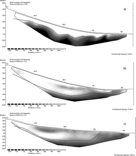
Figure 5 (a–c) Resistivity tomograms of Wenner-Schlumberger surveys along the valley floor in Hrafndalur. (a) Profile i in . (b) Profile j in . (c) Profile c in .
Due to the comparably high mechanical weathering and sedimentary transfer rates, postglacial modification of the Pleistocene glacial landscape is clearly more advanced than in the extended basalt areas of Austfirðir. Anyway, due to the short time since the deglaciation (about 8000 yr), there has been no adjustment of the glacially formed landforms to the geomorphic processes, which have been operating under Holocene morphoclimates.
Comparison of the results from Hrafndalur with data collected in the Austdalur catchment, located in the basalt area to the south (, ) (see also CitationBeylich, 1999, Citation2000, Citation2003, Citation2007), reveals significant differences between the two catchments. Both areas are similar with respect to morphoclimate, vegetation, human impact, and topography, but significantly different with respect to lithology. The rhyolites in Hrafndalur are clearly less resistant than the basalts found in Austdalur (CitationBeylich et al., 2007a), and postglacial modification of the Pleistocene glacial landforms is limited in Austdalur, but significant in Hrafndalur (CitationBeylich, 2000, Citation2007, Citationaccepted). The high level of coupling between slope and channel systems found in Hrafndalur does not exist to the same extent in Austdalur, and results in a lower contribution to bed-load transport in Austdalur. The intensive coupling between slope and fluvial systems in Hrafndalur is strongly connected to the Holocene development of extended talus cones, which partly reach and directly feed into the main channels. By comparison, the Austdalur slope systems are only connected to the main channels via small creeks that drain slopes (CitationBeylich, 1999, Citation2000). Hence, slope and channel systems are largely decoupled in this catchment.
Suspended sediment yields in Hrafndalur are clearly lower than in Austdalur and chemical denudation dominates over suspended sediment yields in the Hrafndalur catchment, while the reverse is the case in Austdalur (). These differences between the two areas can be explained by the significantly higher porosity and connected higher infiltration and water storage capacity of the rhyolites in Hrafndalur as compared to the basalts in Austdalur (see above, CitationBeylich et al., 2007a).
Conclusions
Combined quantitative measurements of the relevant denudative slope processes and stream fluxes in the 7 km2 catchment Hrafndalur situated in a rhyolite area in the northern part of the Icelandic Eastern Fjord region (Austfirðir) provide information on the absolute and relative importance of the different denudative processes and Holocene storage element volumes.
The selected catchment-based approach was effective in analyzing the sediment budget and trends of postglacial relief development in a selected cold environment with given environmental setting. Additional studies carried out with unified geomorphic field methods (CitationBeylich and Warburton, 2007; CitationBeylich et al., 2007b, Citation2008; CitationLamoureux et al., 2007) in cold environments having different morphoclimatic, vegetational, topographic, lithological/geological, and tectonic features will help to gain better understanding of the internal differentiation of high-latitude and high-altitude cold environments (CitationBarsch, 1984, Citation1986). Furthermore, additional information on the control mechanisms of processes, the role of extreme geomorphic events for longer-term mass transfers and sediment budgets, the intensity of geomorphic processes in cold environments, and the relative importance of different processes for slope and valley formation and relief development under different cold environment conditions can be assessed.
Acknowledgments
Research in Hrafndalur was funded by the German Exchange Service (DAAD) (2001, grant to Beylich), the German Science Foundation (DFG) (2002–2004, grant to Beylich), and by the Geological Survey of Norway (NGU) (2004–2007, to Beylich). Additional financial and logistical support was provided by Uppsala University (to Beylich), the University of Würzburg (to Kneisel), and by the Natural Research Centre of Northwestern Iceland (to Beylich and Kneisel). Many thanks go to Katja Laute and Alexander Bast for their support and assistance. We would like to thank the two anonymous referees and the editors for their constructive comments improving this paper.
Related Research Data
References Cited
- Ballantyne, C. K. 2002. Paraglacial Geomorphology. Quaternary Science Reviews 21:1935–2017.
- Barsch, D. 1981. Studien zur gegenwartigen Geomorphodynamik im Bereich der Oobloyah Bay, N-Ellesmere Island, N.W.T., Kanada. Heidelberger Geographische Arbeiten 69:123–161.
- Barsch, D. 1984. Geomorphologische Untersuchungen zum periglazialen Milieu polarer Geosysteme. Zeitschrift für Geomorphologie. N.F., Suppl.-Bd 50:107–116.
- Barsch, D. 1986. Forschungen in Polargebieten. Heidelberger Geowissenschaftliche Abhandlungen 6:33–50.
- Barsch, D. 1993. Periglacial geomorphology in the 21st century. Geomorphology 7:141–163.
- Barsch, D. , M. Gude , R. Mäusbacher , G. Schukraft , and A. Schulte . 1994. Recent fluvial sediment budgets in glacial and periglacial environments, NW Spitsbergen. Zeitschrift für Geomorphologie. Suppl 97:111–122.
- Becht, M. 1995. Untersuchungen zur aktuellen Reliefentwicklung in alpinen Einzugsgebieten. Münchener Geographische Abhandlungen A47.
- Beylich, A. A. 1999. Hangdenudation und fluviale Prozesse in einem subarktisch-ozeanisch geprägten, permafrostfreien Periglazialgebiet mit pleistozäner Vergletscherung–Prozessgeomorphologische Untersuchungen im Bergland der Austfirðir (Austdalur, Ost-Island). Aachen. Berichte aus der Geowissenschaft 130.
- Beylich, A. A. 2000. Geomorphology, sediment budget, and relief development in Austdalur, Austfirðir, East Iceland. Arctic, Antarctic, and Alpine Research 32 4:466–477.
- Beylich, A. A. 2002. Sediment budgets and relief development in present periglacial environments—A morphosystem analytical approach. Hallesches Jahrbuch für Geowissenschaften A24:111–126.
- Beylich, A. A. 2003. Present morphoclimates and morphodynamics in Latnjavagge, the northern Swedish Lapland and Austdalur, East Iceland. Jökull 52:33–54.
- Beylich, A. A. 2007. Quantitative studies on sediment fluxes and sediment budgets in changing cold environments—Potential and expected benefit of coordinated data exchange and the unification of methods. Landform Analysis 5:9–10.
- Beylich, A. A. 2008. Mass transfers, sediment budget and relief development in the Latnjavagge catchment, Arctic-oceanic Swedish Lapland. Zeitschrift für Geomorphologie. N.F 52 1:149–197.
- Beylich, A. A. accepted. Chemical and mechanical fluvial denudation rates in cold environments—Comparison of denudation rates from three catchments in sub-Arctic Eastern Iceland, sub-Arctic Finnish Lapland and Arctic Swedish Lapland. Jökull.
- Beylich, A. A. and D. Gintz . 2004. Effects of high-magnitude/low-frequency fluvial events generated by intense snowmelt or heavy rainfall in Arctic periglacial environments in northern Swedish Lapland and northern Siberia. Geografiska Annaler 86A:11–29.
- Beylich, A. A. and O. Sandberg . 2005. Geomorphic effects of the extreme rainfall event of 20–21 July, 2004 in the Latnjavagge catchment, northern Swedish Lapland. Geografiska Annaler 87A:409–419.
- Beylich, A. A. and J. Warburton . 2007. Analysis of Source-to-Sink-Fluxes and Sediment Budgets in Changing High-Latitude and High-Altitude Cold Environments. SEDIFLUX Manual. First Edition. NGU Report, 2007.053 158.
- Beylich, A. A. , U. Molau , K. Luthbom , and D. Gintz . 2005. Rates of chemical and mechanical fluvial denudation in an Arctic-oceanic periglacial environment, Latnjavagge drainage basin, northernmost Swedish Lapland. Arctic, Antarctic, and Alpine Research 37 1:75–87.
- Beylich, A. A. , S. Etienne , B. Etzelmüller , V. V. Gordeev , J. Käyhkö , V. Rachold , A. J. Russell , K-H. Schmidt , Þ Sæmundsson , F. S. Tweed , and J. Warburton . 2006a. The European Science Foundation (ESF) Network SEDIFLUX—An introduction and overview. Geomorphology 80:3–7.
- Beylich, A. A. , O. Sandberg , U. Molau , and S. Wache . 2006b. Intensity and spatio-temporal variability of fluvial sediment transfers in an Arctic-oceanic periglacial environment in northernmost Swedish Lapland (Latnjavagge catchment). Geomorphology 80:114–130.
- Beylich, A. A. , M. Gustavsson , and E. Kolstrup . 2007a. Experimental weathering of selected non-calcareous rock types under wet/moist conditions. Zeitschrift für Geomorphologie. N.F 51 1:1–26.
- Beylich, A. A. , S. F. Lamoureux , and A. Decaulne . 2007b. Coordinated quantitative studies on sediment fluxes and sediment budgets in changing cold environments—Examples from three SEDIBUD key test areas in Canada, Iceland and Norway. Landform Analysis 5:11–12.
- Beylich, A. A. , S. F. Lamoureux , and A. Decaulne . 2008. The global I.A.G./A.I.G. SEDIBUD (Sediment Budgets in Cold Environments) programme: introduction and overview. Norsk Geografisk Tidsskrift 62 2:50–51.
- Beylich, A. A. , S. F. Lamoureux , and A. Decaulne . in review. Developing quantitative frameworks for studies on sedimentary fluxes and budgets in changing cold environments. Polish Polar Research.
- Caine, N. 1974. In Ives, J. D. and R. G. Barry . The geomorphic processes of the alpine environment. Arctic and Alpine Environments. London Methuen. 721–748.
- Caine, N. Owens, P. N. and O. Slaymaker . 2004. Mechanical and chemical denudation in mountain systems. Mountain Geomorphology. London Arnold. In.
- Caine, N. and F. J. Swanson . 1989. Geomorphic coupling of hillslope and channel systems in two small mountain basins. Zeitschrift für Geomorphologie 33:189–203.
- Clark, M. J. 1988. In Clark, M. J. Periglacial hydrology. Advances in Periglacial Geomorphology. Chichester John Wiley & Sons. 415–462.
- Cockburn, J. M H. and S. F. Lamoureux . 2007. Hydroclimate controls over seasonal sediment yield in two adjacent high arctic watersheds. Hydrological Processes doi: 10.1002/hyp.6798.
- Evans, S. G. and J. J. Clague . 1994. Recent climate change and catastrophic geomorphic processes in mountain environments. Geomorphology 10:107–128.
- Gintz, D. and K-H. Schmidt . 2000. Zeitliche und räumliche Variabilität der Sedimentbereitstellung und des Sedimenttransports im Einzugsgebiet des Levinson-Lessing-Sees (Nordsibirien). Zeitschrift für Geomorphologie Suppl 121:123–138.
- Haeberli, W. and M. Beniston . 1998. Climate change and its impacts on glaciers and permafrost in the Alps. Ambio 27:258–265.
- Hansen, L. , A. A. Beylich , V. Burki , R. Eilertsen , O. Fredin , E. Larsen , A. Lyså , A. Nesje , and J-F. Tønnesen . in press. Stratigraphic architecture and infill history of Erdalen valley, western Norway. Sedimentology.
- Hauck, C. and C. Kneisel . 2008. Applied Geophysics in Periglacial Environments. Cambridge Cambridge University Press.
- Jäckli, H. 1957. Gegenwartsgeologie des Bündnerischen Rheingebietes. Ein Beitrag zur exogenen Dynamik alpiner Gebirgslandschaften. Bern Schweizerische Geotechnische Kommission, Beitrag zur Geologischen Karte der Schweiz. Geotechnische Serie, 36.
- Kneisel, C. 2003. In Schrott, L. , A. Hoerdt , and R. Dikau . Electrical resistivity tomography as a tool for geomorphological investigations—Some case studies. Geophysical Methods in Geomorphology. Zeitschrift für Geomorphologie Suppl 132:37–49.
- Kneisel, C. 2006. Assessment of subsurface lithology in mountain environments using 2D resistivity imaging. Geomorphology 80:32–44.
- Lamoureux, S. F. 1999. Spatial and inter-annual variations in sedimentation patterns recorded in nonglacial varved sediments from the Canadian high Arctic. Journal of Paleolimnology 21:73–84.
- Lamoureux, S. F. , A. A. Beylich , and A. Decaulne . 2007. Sediment fluxes and budgets in high-latitude and high-altitude cold environments. Sediment Budgets in Cold Environments (SEDIBUD) Second Workshop; Abisko, Sweden, 15–19 September 2007. EOS (Transactions, American Geophysical Union) 25 12 88 52:580.
- Orwin, J. F. and C. C. Smart . 2004. Short-term spatial and temporal patterns of suspended sediment transfer in proglacial channels, Small River Glacier, Canada. Hydrological Processes 18:1521–1542.
- Otto, J-C. and R. Dikau . 2004. Geomorphologic system analysis of a high mountain valley in the Swiss Alps. Zeitschrift für Geomorphologie 48:323–341.
- Rapp, A. 1960. Recent development of mountain slopes in Kärkevagge and surroundings, Northern Scandinavia. Geografiska Annaler 42:71–200.
- Rapp, A. 1985. In Church, M. and O. Slaymaker . Extreme rainfall and rapid snowmelt as causes of mass movements in high latitude mountains. Field and Theory: Lectures in Geocryology. Vancouver University of British Columbia Press. 36–56.
- Reynolds, J. M. 1997. An Introduction to Applied and Environmental Geophysics. Chichester Wiley.
- Schrott, L. , A. Niederheide , M. Hankammer , G. Hufschmidt , and R. Dikau . 2002. Sediment storage in a mountain catchment: geomorphic coupling and temporal variability (Reintal, Bavarian Alps, Germany). Zeitschrift für Geomorphologie N.F 175–196.
- Schrott, L. , G. Hufschmidt , M. Hankammer , T. Hoffmann , and R. Dikau . 2003. Spatial distribution of sediment storage types and quantification of valley fill deposits in an alpine basin, Reintal, Bavarian Alps, Germany. Geomorphology 55:45–63.
- Slaymaker, O. 2008. Sediment budget and sediment flux studies under accelerating global change in cold environments. Zeitschrift für Geomorphologie N.F 52 1:123–148.
- Slaymaker, O. , C. Souch , B. Menounos , and G. Filippelli . 2003. Advances in Holocene mountain geomorphology inspired by sediment budget methodology. Geomorphology 55:305–316.
- Warburton, J. 1993. Energetics of Alpine proglacial geomorphic processes. Transactions of the Institute of British Geographers 18:197–206.
- Warburton, J. 2006. In Perry, C. and K. Taylor . Mountain environments. Environmental Sedimentology. Oxford Blackwell.