Abstract
Surface fluxes are important boundary conditions for climatological modeling and the Asian monsoon system. The recent availability of high-resolution, multi-band imagery from the ASTER (Advanced Space-borne Thermal Emission and Reflection radiometer) sensor has enabled us to estimate surface fluxes to bridge the gap between local-scale flux measurements using micrometeorological instruments and regional scale land-atmosphere exchanges of water and heat fluxes that are fundamental for the understanding of the water cycle in the Asian monsoon system. A Surface Energy Balance System (SEBS) method based on ASTER data and field observations has been proposed and tested in this paper for deriving net radiation flux (R n), soil heat flux (G 0), sensible heat flux (H), and latent heat flux (λE) over a heterogeneous land surface. As a case study, the methodology was applied to an experimental area at NamCo, located at the central Tibetan Plateau, China. The ASTER data of 11 June 2006, 29 October 2007, and 25 February 2008 was used in this paper for the NamCo area case. To validate the proposed methodology, the ground-measured land surface heat fluxes (net radiation flux (R n), soil heat flux (G 0), sensible heat flux (H), and latent heat flux (λE)) were compared to the ASTER derived values. The results show that the derived land surface heat fluxes in different months over the study area are in good accordance with the land surface status. The tendency is basically to maintain consistency. It is therefore concluded that the proposed methodology is successful for the retrieval of land surface heat fluxes using the ASTER data and filed observations over the study area.
Introduction
The energy and water cycles play an important role in the Asian monsoon system over the Tibetan Plateau. The Tibetan Plateau contains the world's highest elevation with an average elevation for relief features of about 4000 m. It represents an extensive mass extending from subtropical to middle latitudes and spans more than 25° of longitude. Because of its topographic character, the plateau surface absorbs a large amount of solar radiation energy (much of which is redistributed by cryospheric processes), and undergoes dramatic seasonal changes of surface heat and water fluxes (e.g., CitationYe and Gao, 1979; CitationYe, 1981; CitationYanai et al., 1992; CitationYe and Wu, 1998; CitationMa et al., 2002, Citation2006; CitationMa and Tsukamoto, 2002). Some interesting detailed studies concerning the land surface heat fluxes have been reported in the northern Tibetan Plateau (e.g., CitationYang et al., 2002, Citation2003; CitationMa et al., 2002; CitationChoi et al., 2004; CitationZuo et al., 2005; CitationMa and Ma, 2006). These researches were, however, on point-level or a local-patch-level. Since land-surface atmosphere interaction information is required for this area, the aggregation of the individual results into a regional scale is necessary.
Remote sensing offers the possibility to derive regional distribution of land surface heat fluxes over a heterogeneous land surface in combination with sparse field experimental stations. Remote sensing data provided by satellites are a means of obtaining consistent and frequent observations of spectral albedo and emittance of radiation at elements in a patch landscape and on a global scale (CitationSellers et al., 1990). The land surface variables and vegetation variables, such as surface temperature (T sfc), surface hemispherical albedo (r 0), NDVI, MSAVI, LAI, and surface thermal emissivity (ϵ) can be derived directly from satellite observations (e.g., CitationSusskind et al., 1984; CitationChe'din et al., 1985; CitationTucker, 1986; CitationWan and Dozier, 1989; CitationMenenti et al., 1989; CitationBecker and Li, 1990, Citation1995; CitationWatson et al., 1990; CitationBaret and Guyot, 1997; CitationPrice, 1992; CitationKahle and Alley, 1992; CitationLi and Becker, 1993; CitationQi et al., 1994; CitationNorman et al, 1995; CitationSchmugge et al., 1995; CitationKustas and Norman, 1997; CitationSobrino and Raissouni, 2000; CitationSu, 2002; CitationMa et al., 2003a, Citation2003b; CitationOku and Ishikawa, 2004; CitationKato and Yamaguchi, 2005). The regional heat fluxes can be determined indirectly with the aid of these land surface variables and vegetation variables (CitationPinker, 1990).
Recent studies have explored several approaches to estimate the regional distribution of surface heat fluxes. These methods require specification of the vertical temperature difference between the surface temperature and the air temperature and an exchange resistance (e.g., CitationKustas et al., 1989; CitationKustas, 1990; CitationWang et al., 1995; CitationMenenti et al., 1991; CitationMenenti and Choudhury, 1993; CitationBastiaanssen, 1995; CitationKustas and Norman, 1997; CitationSu, 2002). However, these remote sensing retrieval methods have been performed in homogeneous moist or semiarid regions, and investigations in heterogeneous landscapes of high altitude (e.g., the Tibetan Plateau area) are rare.
NOAA/AVHRR, GMS, and Landsat-7 ETM data have been used to determine regional land surface heat fluxes over the heterogeneous landscape of the Tibetan Plateau (CitationMa et al., 2003a, Citation2003b, Citation2005, Citation2006; CitationOku et al., 2007). However, the resolution of the NOAA/AVHRR and GMS data is about 1 km × 1 km and sub-pixel heterogeneity has been omitted. This is also the case with Landsat-7 ETM data. The aim of this research is to upscale in situ point observations of land surface variables and land surface heat fluxes to the regional scale using high-resolution (15 m × 15 m) ASTER data.
Data and Methodology
DATA
The recent availability of high-resolution, multi-band imagery from the ASTER sensor has enabled us to estimate surface fluxes. ASTER covers a wide spectral region with 14 bands from the visible to the thermal infrared with high spatial, spectral, and radiometric resolution. The spatial resolution varies with wavelength: 15 m in the visible and near-infrared (VNIR, 0.52–0.86 µm), 30 m in the shortwave infrared (SWIR, 1.6–2.43 µm), and 90 m in the thermal infrared (TIR, 8.1–11.6 µm) (CitationYamaguchi et al., 1998).
The most relevant data, collected at the NamCo station (CitationMa et al., 2008) to support the parameterization of land surface heat fluxes and analysis of ASTER images in this paper, consist of surface radiation budget components, surface radiation temperature, surface albedo, humidity, wind speed and direction measured at the Atmospheric Boundary Layer (ABL) tower; turbulent fluxes measured by the eddy correlation (EC) technique; soil heat flux; soil temperature profiles; soil moisture profiles; and the vegetation state (). The sensible heat flux and latent heat flux using EC system is made by Campbell (CSAT3). So far, EC has been recognized as the best measurement tool for sensible heat flux and latent heat flux. The measurement resolution: ux and uy are 1 mm/s rms; uz is 0.5 mm/s rms; c is 15 mm/s (0.025 °C) rms. Accuracy assumes −30 to +50 °C range; wind speeds <30 m/s; and wind angles of ±170°.
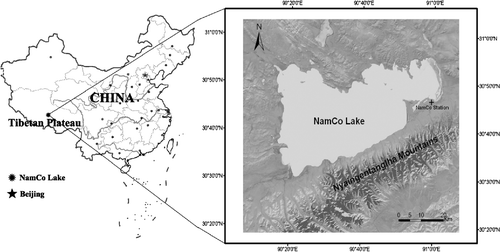
FIGURE 1 The goal of the study was to retrieve land surface heat fluxes using the NamCo area in the central Tibetan Plateau area of China. On the right is a Landsat TM map of the study area (Source for this data set was the Global Land Cover Facility at the University of Maryland; http://www.landcover.org.), including NamCo Lake and NamCo Station (compare with ). Elevations in this area range from 4718 m for NamCo Lake and 4730 m at NamCo Station up to 7111 m in the mountains to the southeast. The location of NamCo Lake within China is shown in the sketch map on the left. Dots are major cities within China, and the dashed line shows the limits of claimed Chinese territory.
THEORY AND SCHEME
A Surface Energy Balance System (SEBS; CitationSu, 2002) was proposed for the estimation of atmospheric turbulent fluxes and evaporative fraction using satellite earth observation data, in combination with meteorological information at proper scales. SEBS consists of: a set of tools for the determination of the land surface physical parameters, such as surface albedo, emissivity, surface temperature, vegetation coverage, etc., from spectral reflectance and radiance measurements; it is a model for the determination of the roughness length for heat transfer (CitationSu, 2002).
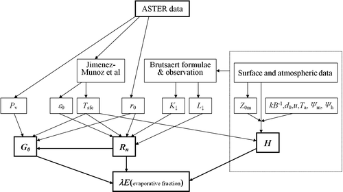
In this study, the SEBS retrieval algorithm is used for the ASTER data. The general concept of the methodology is shown in a diagram (). The surface albedo for shortwave radiation (r 0) is retrieved from narrowband-broadband conversion by Liang (CitationLiang, 2001). The land surface temperature (T sfc) is derived using a method developed by Juan et al. (2006) from multispectral thermal infrared data. Juan et al. (2006) also evaluated a technique to extract emissivity information from multispectral thermal infrared data adding vegetation information. The radiative transfer model SMAC (CitationRahman and Dedieu, 1994) computes the downward shortwave and longwave radiation at the surface. With these results the surface net radiation flux (R n) is determined. On the basis of the field observations, the soil heat flux (G 0) is estimated from net radiation flux (R n). The sensible heat flux (H) is estimated from T sfc, and regional latent heat flux (λE) is derived as the residual of the energy budget theorem (CitationLiou, 2004; CitationMa et al., 2006) for land surface.
FIGURE 2 Diagram of parameterization procedure by combining Advanced Space-borne Thermal Emission and Reflection radiometer (ASTER) data with field observations. The method of CitationJimenez-Munoz et al. (2006) yields land surface temperature and emissivity. SMAC is radiative transfer model; Pv is vegetation coverage; ϵ0 is emissivity; Tsfc is land surface temperature; r0 is land surface albedo for shortwave radiation; K↓ is shortwave radiation; L↓ is longwave radiation; Z0m is roughness height for momentum transfer; kB−1 is the excess resistance for heat transportation; d0 is zero plane displacement height; u is mean wind speed; Ta is air temperature; Ψm is stability correction function for momentum; Ψh is stability correction function for sensible heat transfer; G0 is the soil heat flux; Rn is the net radiation flux; λE is the regional latent heat flux; and H is the sensible heat flux.
The net radiation flux R
n is estimated as
where ϵ
0(x,y) is surface emissivity, K
↓(Wm−2) represents the shortwave (0.3–3 µm), and L
↓(Wm−2) the longwave (3–100 µm) radiation components, respectively. Surface albedo r
0(x,y) is derived from the narrowband-broadband conversion method by CitationLiang (2001). Since ASTER has nine bands, it is expected that so many bands should enable us to convert narrowband to broadband albedos effectively. CitationLiang (2001) found that the conversions are quite linear. The resultant linear equations are collated as follows:
where i (i = 1–9) are the correspondent ASTER band surface reflectances.
The equation to calculate soil heat flux is parameterized as (CitationSu, 2002):
in which it is assumed that the ratio of soil heat flux to net radiation Γ
c
= 0.05 for the full vegetation canopy (CitationMonteith, 1973), and Γ
s
= 0.315 for bare soil (CitationKustas et al., 1989). An interpolation is then performed between these limiting cases using the fractional canopy coverage, fc
.
In order to derive the sensible and latent heat flux, similarity theory (CitationMonin and Obukhov, 1954) will be used here. In ASL (Atmospheric Surface Layer), the similarity relationships for the profiles of the mean wind speed, u, and the mean temperature, θ
0 − θ
a, are usually written in integral form as (CitationMonin and Obukhov, 1954):
where z is the height above the surface, u
* = (τ
0/ρ)1/2 is the friction velocity, τ
0 is the surface shear stress, ρ is the density of air, k = 0.4 is von Karman's constant, d
0 is the zero plane displacement height, z
0m
is the roughness height for momentum transfer, θ
0 is the potential temperature at the surface, θa
is the potential air temperature at height z, z
0h
is the scalar roughness height for heat transfer, ψm
and ψh
are the stability correction functions for momentum and sensible heat transfer, respectively. L is the Obukhov length defined as (CitationMonin and Obukhov, 1954):
where g is the acceleration due to gravity and θv
is the potential virtual temperature near the surface.
Normally the latent heat flux λE is the residual resulting from an application of the energy budget theorem to the land surface (CitationMa et al, 2006):
but SEBS use the evaporative fraction to derived latent heat flux, which is estimated by:
The latent heat flux () can then be calculated by
Case Studies and Validation
As a case study, three scenes of ASTER data over the NamCo area of the Tibetan Plateau are used here. shows the input data of SEBS. shows the distribution maps of surface heat fluxes around the NamCo area. shows the validation of the derived net radiation R n, soil heat flux G 0, sensible heat flux H, and latent heat flux λE against ground measurements over the NamCo area with a 1∶1 line.
FIGURE 3 Distribution maps of land surface heat fluxes over the area around NamCo Station (compare with ).
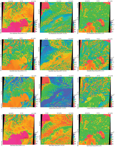
FIGURE 4 Validation of the derived net radiation (R n), soil heat flux (G 0), sensible heat flux (H), and latent heat flux (λE) against ground measurements over the NamCo station with 1∶1 line. Observation time: 12:40 (Beijing Time).
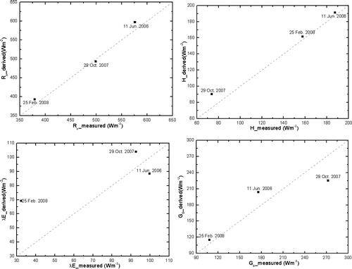
TABLE 1 The input observation data of the Surface Energy Balance System (SEBS).
The results show the following:
The derived surface heat fluxes (net radiation flux R n, soil heat flux G 0, sensible heat flux H, and latent heat flux λE) in different months over the study area are in good accordance with the land surface status. The experimental area includes a variety of land surfaces such as a large area of grassy marshland, some desertification grassland areas, many small rivers and NamCo lake; therefore, these derived parameters show a wide range due to the strong contrast of surface features. Net radiation flux changed from 300 to 730 W m−2 in February, from 150 to 990 W m−2 in June, and from 290 to 770 W m−2 in October. Soil heat flux varied from 90 to 230 W m−2 in February, from 50 to 300 W m−2 in June, and from 30 to 230 W m−2 in October. Sensible heat flux ranged from 100 to 330 W m−2 in February, from 60 to 400 W m−2 in June, and from 35 to 480 W m−2 in October. Latent heat flux varied from 0 to 300 W m−2 in February, from 15 to 550 W m−2 in June, and from 0 to 500 W m−2 in October (see ).
The derived net radiation flux over the study area is very close to the field measurements; the absolute percent difference (APD) is 3.5%, which is the result of improvement in surface albedo and surface temperature. The regional soil heat flux derived from the relationship between soil heat flux and net radiation flux is suitable for heterogeneous land surface of the NamCo area, because the relationship itself was derived from the same area.
The derived regional sensible heat flux and latent heat flux at the validation sites in the NamCo area are in good agreement with field measurements (). Although it has a deviation, it may also reflect the surface status in the NamCo area. This is due to the fact that atmospheric boundary layer processes have been considered in more detail in our methodology, and the proposed parameterization for sensible heat flux and latent heat flux can be used over the NamCo area. In the input observation data can be seen clearly.
Concluding remarks
In this study, the regional distributions of land surface heat fluxes (net radiation flux, soil heat flux, sensible heat flux, and latent heat flux) over the heterogeneous central Tibetan Plateau area were derived with the aid of ASTER data and field observations. Reasonable results of land surface heat fluxes were gained in this study.
The retrieval of regional land surface heat fluxes over a heterogeneous landscape is not an easy task.
Only three ASTER images are used in this study. To obtain more accurate regional land surface fluxes (daily to seasonal variations) over a larger area (the Tibetan Plateau), more field observations (ABL tower and radiation measurement system, radiosonde system, turbulent fluxes measured by the eddy correlation technique, soil moisture and soil temperature measurement system, etc.) and other satellite sensors such as MODIS (Moderate Resolution Imaging Spectroradiometer) and NOAA (National Oceanic and Atmospheric Administration)/AVHRR (Advanced Very High Resolution Radiometer) with more frequent temporal coverage have to be used.
This study implies the SEBS method is only applicable to clear-sky days. In order to extend its applicability to cloudy skies, we should consider using microwave remote sensing data to derive surface temperature and other land surface variables.
SEBS has been developed to estimate atmospheric turbulent fluxes using satellite earth observation data, in combination with meteorological data from a proper reference height given by either in situ measurements for application to a point, or radiosonde or meteorological forecasts for application at larger scales. On the basis of these experimental validations, SEBS can be used to estimate turbulent heat fluxes at different scales with acceptable accuracy.
Acknowledgments
The work is supported by National Project 973 (2010CB951701), Knowledge Innovation Project of the Chinese Academy of Sciences (KZCX2-YW-QN309, KZCX2-YW-Q10-2), NSFC (40705004, 40825015 and 40810059006), Chinese National Key Programme for Developing Basic Sciences (2005CB422003), the Key Projects of International Cooperation, Chinese Academy of Sciences (GJHZ0735) and the EU-FP7 project “CEOP-AEGIS” (212921).
Related Research Data
References Cited
- Baret, F. and G. Guyot . 1997. Potentials and limits of vegetation indices for LAI and APAR assessment. Remote Sensing of Environment 35:161–173.
- Bastiaanssen, W. G. M. 1995. Regionalization of Surface Flux Densities and Moisture Indicators in Composite Terrain. Ph.D. thesis. Wageningen Agricultural University, Wageningen, Netherlands. 143–161.
- Becker, F. and Z-L. Li . 1990. Towards a local split window method over land surfaces. International Journal of Remote Sensing 11:369–393.
- Becker, F. and Z-L. Li . 1995. Surface temperature and emissivity at various scales: definition, measurement and related problems. Remote Sensing Reviews 12:225–253.
- Che'din, A. , N. A. Scott , C. Wahiche , and P. Moulinier . 1985. The improved initialisation inversion method: a high resolution physical method for temperature retrievals from Tiros-N series. Journal of Climate and Applied Meteorology 24:124–143.
- Choi, T. , J. Hong , J. Kim , H. Lee , J. Asanuma , H. Ishikawa , O. Tsukamoto , G. Zhiqui , Y. Ma , K. Ueno , J. Wang , T. Koike , and T. Yasunari . 2004. Turbulent exchange of heat, water vapor, and momentum over a Tibetan prairie by eddy covariance and flux variance measurements. Journal of Geophysical Research 109:article D21106. doi:10.1029/2004JD004767.
- Jiménez-Muñoza, J. C. , J. Sobrino , A. Gillespie , D. Sabolb , and T. William . 2006. Improved land surface emissivities over agricultural areas using ASTER NDVI. Remote Sensing of Environment 103:474–487.
- Kahle, A. B. and R. E. Alley . 1992. Separation of temperature and emittance in remotely sensed radiance measurements. Remote Sensing of Environment 42:107–112.
- Kato, S. and Y. Yamaguchi . 2005. Analysis of urban heat-island effect using ASTER and ETM+ data: separation of anthropogenic heat discharge and natural heat radiation from sensible heat flux. Remote Sensing of Environment 99:44–54.
- Kustas, W. P. 1990. Estimates of evapotranspiration with a one- and two-layer model of heat transfer over partial canopy cover. Journal of Applied Meteorology 29:704–715.
- Kustas, W. P. and J. M. Norman . 1997. A two-source approach for estimating turbulent fluxes using multiple angle thermal infrared observations. Water Resources Research 33:1495–1508.
- Kustas, W. P. , B. J. Choudhury , M. S. Moran , R. J. Reginato , R. D. Jackson , L. W. Gay , and H. L. Weaver . 1989. Determination of sensible heat flux over sparse canopy using thermal infrared data. Agricultural and Forest Meteorology 44:197–216.
- Li, Z-L. and F. Becker . 1993. Feasibility of land surface temperature and emissivity determination from AVHRR data. Remote Sensing of Environment 43:67–85.
- Liang, S. 2001. Narrowband to broadband conversions of land surface albedo. Remote Sensing of Environment 76:213–238.
- Liou, K. N. 2004. An Introduction to Atmospheric Radiation. 2nd edition. Beijing China Meteorology Press.
- Ma, W. and Y. Ma . 2006. The annual variations on land surface energy in the northern Tibetan Plateau. Environmental Geology 50 5: doi:10.1007/s00254-006-0238-9.
- Ma, Y. and O. Tsukamoto . 2002. Combining Satellite Remote Sensing with Field Observations for Land Surface Heat Fluxes over Inhomogeneous Landscape. Beijing China Meteorology Press.
- Ma, Y. , O. Tsukamoto , J. Wang , H. Ishikawa , and I. Tamagawa . 2002. Analysis of aerodynamic and thermodynamic parameters over the grassy marshland surface of Tibetan Plateau. Progress in Natural Science 12:36–40.
- Ma, Y. , Z. Su , T. Koike , T. Yao , H. Ishikawa , K. Ueno , and M. Menenti . 2003a. On measuring and remote sensing surface energy partitioning over the Tibetan Plateau—From GAME/Tibet to CAMP/Tibet. Physics and Chemistry of the Earth 28:63–74.
- Ma, Y. , H. Ishikawa , O. Tsukamoto , M. Menenti , Z. Su , T. Yao , T. Koike , and T. Yasunari . 2003b. Regionalization of surface fluxes over heterogeneous landscape of the Tibetan Plateau by using satellite remote sensing. Journal of the Meteorological Society of Japan 81:277–293.
- Ma, Y. , S. Fan , H. Ishikawa , O. Tsukamoto , T. Yao , T. Koike , H. Zuo , Z. Hu , and Z. Su . 2005. Diurnal and inter-monthly variation of land surface heat fluxes over the central Tibetan Plateau area. Theoretical and Applied Climatology 80:259–273.
- Ma, Y. , L. Zhong , Z. Su , H. Ishikawa , M. Menenti , and T. Koike . 2006. Determination of regional distributions and seasonal variations of land surface heat fluxes from Landsat-7 Enhanced Thematic Mapper data over the central Tibetan Plateau area. Journal of Geophysical Research 111:article D10305. doi:10.1029/2005JD006742.
- Ma, Y. , S. C. Kang , L. P. Zhu , B. Q. Xu , L. Tian , and T. D. Yao . 2008. Tibetan Observation and Research Platform atmosphere-land Interaction over a heterogeneous landscape. Bulletin of the American Meteorological Society 89 10:1487–1492.
- Menenti, M. and B. J. Choudhury . 1993. Parameterization of land surface evaporation by means of location dependent potential evaporation and surface temperature range. In Bolle, H. J. , R. A. Feddes , and J. D. Kalma . (eds.). Exchange Processes at the Land Surface for a Range of Space and Time Scales IAHS Publication. 212:561–568.
- Menenti, M. , W. G. M. Bastiaanssen , and D. Van Eick . 1989. Determination of hemispheric albedo with Thematic Mapper data. Remote Sensing of Environment 28:327–337.
- Menenti, M. , W. G. M. Bastiaanssen , K. Hefny , and M. H. Abd El Karim . 1991. Mapping of ground water losses by evaporation in the Western Desert of Egypt., Wageningen, Netherlands: DLO Winand Staring Center, Report 43:. 1–116.
- Monin, A. S. and A. M. Obukhov . 1954. Basic laws of turbulent mixing in the ground layer of the atmosphere. Trans. Geophys. Inst. Akad. Nauk. USSR 151:163–187.
- Monteith, J. L. 1973. Principles of Environmental Physics. London Edward Arnold Press. 241 pp.
- Norman, J. M. , W. P. Kustas , and K. S. Humes . 1995. A two-source approach for estimating soil and vegetation energy fluxes from observations of directional radiometric surface temperature. Agricultural and Forest Meteorology 77:263–293.
- Oku, Y. and H. Ishikawa . 2004. Estimation of land surface temperature over the Tibetan Plateau using GMS data. Journal of Applied Meteorology 43:548–561.
- Oku, Y. , H. Ishikawa , and Z. Su . 2007. Estimation of land surface energy fluxes over the Tibetan Plateau using GMS data. Journal of Applied Meteorology and Climatology 46:183–195.
- Pinker, R. T. 1990. Satellites and our understanding of the surface energy balance. Palaeogeography Palaeoclimatology Palaeoecology 82:321–342.
- Price, J. C. 1992. Estimating vegetation amount from visible and near infrared albedo. Remote Sensing of Environment 41:29–34.
- Qi, J. , A. Chehbouni , A. R. Huete , Y. H. Kerr , and S. Sorooshian . 1994. A modified soil adjusted vegetation index. Remote Sensing of Environment 48:119–126.
- Rahman, H. and G. Dedieu . 1994. SMAC: a simplified method for atmospheric correction of satellite measurements in the solar spectrum. International Journal of Remote Sensing 15:123–143.
- Schmugge, T. J. , S. Hook , and A. Kahle . 1995. TIMS observation of surface emissivity in HAPEX-Sahel. Paper presented at International Geoscience and Remote Sensing Symposium, Institute of Electrical and Electronics Engineers, Florence, Italy, July.
- Sellers, P. J. , S. I. Rasool , and H. J. Bolle . 1990. A review of satellite data algorithms for studies of the land surface. Bulletin of the American Meteorological Society 71:1429–1447.
- Sobrino, J. A. and N. Raissouni . 2000. Toward remote sensing methods for land cover dynamic monitoring: application to Morocco. International Journal of Remote Sensing 21 (2):353–366.
- Su, Z. 2002. The Surface Energy Balance System (SEBS) for estimation of turbulent heat fluxes. Hydrology and Earth System Sciences 6:85–99.
- Susskind, J. , J. Rosenfield , D. Renter , and M. T. Chahine . 1984. Remote sensing of weather and climate parameters from HIRS2/MSU on TIROS-N. Journal of Geophysical Research 89:4677–4697.
- Tucker, C. J. (ed.). 1986. Monitoring the grasslands of semi-arid Africa using NOAA AVHRR data. International Journal of Remote Sensing 7 (11):1383–1622.
- Wan, Z. and J. Dozier . 1989. Land surface temperature measurement from space: physical principles and inverse modelling. IEEE Transactions on Geoscience and Remote Sensing 27:268–278.
- Wang, J. , Y. Ma , M. Menenti , W. G. M. Bastiaanssen , and Y. Mistsuta . 1995. The scaling-up of processes in the heterogeneous landscape of HEIFE with the aid of satellite remote sensing. Journal of the Meteorological Society of Japan 73:1235–1244.
- Watson, K. , F. Kruse , and S. Hummer-Miler . 1990. Thermal infrared exploration in the Carlin trend. Geophysics 55:70–79.
- Yamaguchi, Y. , A. B. Kahle , H. Tsu , T. Kawakami , and M. Pniel . 1998. Overview of the Advanced Spaceborne Thermal Emission and Reflection Radiometer (ASTER). IEEE Transactions on Geoscience and Remote Sensing 36 4:1062–1071.
- Yanai, M. , C. Li , and Z. Song . 1992. Seasonal heating of the Tibetan Plateau and its effects on the evolution of the Asian summer monsoon. Journal of the Meteorological Society of Japan 70:319–351.
- Yang, K. , T. Koike , H. Fujii , K. Tamagawa , and N. Hirose . 2002. Improvement of surface flux parameterizations with a turbulence-related length. Quarterly Journal of the Royal Meteorological Society 128B:2073–2088.
- Yang, K. , T. Koike , and D. Yang . 2003. Surface flux parameterization in the Tibetan Plateau. Boundary Layer Meteorology 116:245–262.
- Ye, D. 1981. Some characteristics of the summer circulation over the Qinghai-Xizang (Tibet) Plateau and its neighborhood. Bulletin of the American Meteorological Society 62:14–19.
- Ye, D. and Y. Gao . 1979. The Meteorology of the Qinghai-Xizang (Tibet) Plateau. Beijing Science Press. 278 pp. (in Chinese).
- Ye, D. and G. Wu . 1998. The role of the heat source of the Tibetan Plateau in the general circulation. Meteorology and Atmospheric Physics 67:181–198.
- Zuo, H. , Y. Hu , D. Li , S. Lu , and Y. Ma . 2005. Seasonal transition and its boundary characteristics in Amdo area of Tibetan Plateau. Progress in Natural Science 15:239–245.