
Abstract
A lake sediment sequence from southern Store Koldewey, north-east Greenland, has been investigated using a multidisciplinary approach, including geophysical, geochemical, biogeochemical, biological and sedimentological methods. Chronological constraints are provided by accelerator mass spectrometry (AMS) 14C dating of bulk sediment and complemented with published water moss ages. The record consists of three major sediment units. Their individual structural, textural, geophysical and geochemical characteristics indicate variable input of sediment and meltwater due to variable proximity of the ice margin and therefore reflect the growth and decay of a local glacier during the late Weichselian. Radiocarbon dating of bulk sediment samples from the lowermost unit gave ages of 42 to 34 calibrated thousand years (cal Ky B.P.) and indicates that this material is redeposited in the lake basin during or after the ice advance at the end of the Pleistocene. Increased meltwater and sediment input from a retreating ice margin following the Younger Dryas is indicated by the occurrence of a sandy to gravely section. Fine-grained and laminated sediments were deposited during the Pleistocene–Holocene transition and indicate calm sedimentation conditions with an ice margin outside of the lake catchment. The reoccurrence of coarse sediments during the early Holocene may indicate increased meltwater input in response to the cold spell at about 9.3 Kya with increased snow accumulation rather than fluctuations of local glaciers. The dating results furthermore show that AMS 14C dating of bulk sediment samples deposited during glacier decay in High Arctic environments can give problematic ages.
The extent of the Greenland Ice Sheet and its margin configuration during the LGM in east and north-east Greenland, and the ice decay after the culmination, have been of interest over the last few decades and have been investigated using different archives. On the basis of geomorphological and lithostratigraphical correlation, Hjort (Citation1981) suggested a Weichselian glacial chronology for north-east Greenland, with a succession of three glaciations of gradually smaller extension. Later, Hjort & Björck (Citation1984) concluded on the basis of a subsequent study, which included palynological results, that the two older glaciations—the Kap Mackenzie and the Muschelbjerg stadials—are of Saalian age or even older. Hjort & Björck (Citation1984) also concluded that the youngest Weichselian glaciation, the Nanok II stadial, occurred during the late Weichselian and was the least extensive, with partly ice-free lowlands and some nunataks. Within the framework of the Polar North Atlantic Margins, Late Cenozoic Evolution project, the extent of the Greenland Ice Sheet during the Weichselian and the position of the ice margin during the LGM in north-east Greenland were reinvestigated, resulting in a more complex glaciation history with regional differences with regard to ice extent and timing of decay and recessional stages (e.g., Björck, Wohlfarth et al. Citation1994; Funder et al. Citation1994; Hansen et al. Citation1994; Houmark-Nielsen et al. Citation1994; Landvik Citation1994; Landvik et al. Citation1994).
Abbreviations
AMS: accelerator mass spectrometry
cal Ky B.P.: thousand calendar years before present
cal yr B.P.: calendar years before present
GPS: global positioning system
HA: humic acid fraction
HAF: humic acid-free fraction
Ky(a): thousands of years (ago)
LGM: Last Glacial Maximum
MIS: marine isotope stage
MS: magnetic susceptibility
SI: International System of Units
TC: total carbon
TOC: total organic carbon
WBD: wet bulk density
XRF: x-ray fluorescence spectrometry
On Hochstetter Forland, south of the study area (ca. 75.5°N, 20.0°W; a), dating of shells of marine bivalves from deltaic sediments inside the Nanok I moraine indicated that part of this area was glaciated until the beginning of the Holocene (Hjort Citation1981; Björck, Wohlfarth et al. Citation1994). On Germania Land, north of the study area (ca. 77.0°N, 19.0°W), evidence of two major glaciations was found (Landvik Citation1994). The older, undated glaciation covered the entire area and extended onto the continental shelf. Based on deglaciation dates and the marine limit, the younger glaciation was suggested to be of late Weichselian age, with a margin beyond the present coast line and some ice-free low-relief mountains on eastern Germania Land (Landvik Citation1994). Recent investigations of seafloor morphological features show that the margin of the Greenland Ice Sheet during LGM in north-east Greenland reached farther onto the shelf (Evans et al. Citation2009; Winkelmann et al. Citation2010) than what was previously suggested by Funder (Citation1989), Landvik (Citation1994) and Funder & Hansen (Citation1996).
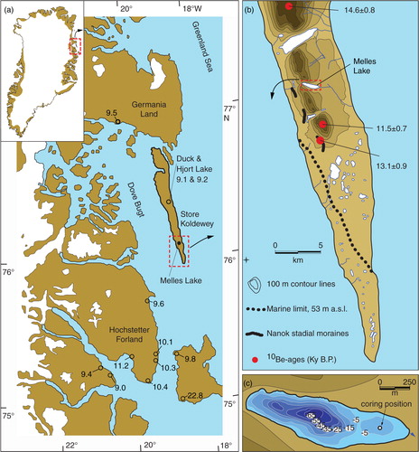
Fig. 1 (a) Overview of present ice-free Greenland (inset) and the study area in north-east Greenland with regional minimal ages for the last deglaciation (open circles) after Hjort (Citation1981), Björck, Bennike et al. (1994), Landvik (Citation1994), Wagner et al. (Citation2007) and Klug, Schmidt et al. (Citation2009). (b) Southern Store Koldewey with 100 m contour intervals, cosmogenic exposure ages (Håkansson et al. Citation2007), the positions of moraines and the marine limit after Hjort (Citation1981). (c) Bathymetry and surrounding topography of Melles Lake with coring position in the eastern basin.
The deglaciation after the LGM occurred in discrete steps when rising sea level induced calving of the floating and grounded ice on the shelf and large marine areas including parts of the fjords became ice-free (Funder & Hansen Citation1996). A Younger Dryas re-advance of glaciers in east and north-east Greenland between 12.4 and 11.4 cal Ky B.P. has been suggested (Hjort Citation1979; Hjort & Björck Citation1984; Björck et al. Citation1997; Funder et al. Citation1998; Kelly et al. Citation2008). This was followed by deglaciation of land-based ice in coastal areas after 11.5 cal Ky B.P. (Bennike & Björck Citation2002; Cremer et al. Citation2008; Wagner et al. Citation2010; Funder et al. Citation2011), a process enhanced by the rapid warming after the Pleistocene–Holocene transition (Funder & Hansen Citation1996; Funder et al. Citation2011).
Lacustrine sedimentary records (Cremer et al. Citation2008) and macrofossil remains (Bennike & Björck Citation2002) from north-east Greenland document that most areas at the outer coast were deglaciated within a period of about 1500 years after the beginning of the Holocene.
In this article, we present a sedimentary succession from a lake on southern Store Koldewey, north-east Greenland. The multidisciplinary study including high-resolution MS, micro x-ray fluorescence, core scanner data, granulometric data and fossil enumeration allows for the reconstruction of the late Pleistocene to early Holocene environmental change. It also enables testing earlier suggestions of ice-free areas in coastal regions of north-east Greenland against recent evidence for extensive glaciation of the shelf during the LGM.
Study area, material and methods
Study area
In north-east Greenland, the island of Store Koldewey is some 80 km long and up to 11 km wide and is orientated north–south (a). Store Koldewey lies between the Greenland Sea to the east and, to the west, the Dove Bugt embayment, which separates the island from the mainland. A steep-sloped, flat-topped mountain range, 500–900 m a.s.l., dominates the morphology of the western part of Store Koldewey, whereas the eastern part comprises a gently sloping plateau at ca. 200–100 m a.s.l. towards a coastal cliff. Several east–west-orientated valleys of various dimensions dissect the mountain range (b). Lowlands are found to the north and south of the island.
The mountain range consists of Caledonian crystalline rocks—mainly gneisses—and the mountain tops are covered by block fields. Jurassic, Cretaceous and Early Pleistocene marine sediments are exposed at the eastern coastal cliff; Quaternary till, raised marine and littoral sediments are found on the eastern plateau and on lowlands (Escher & Pulvertaft Citation1995; Henriksen et al. Citation2000; Bennike et al. Citation2004; Bennike et al. Citation2010).
High-Arctic climate conditions with mean monthly temperatures of −23°C in February and 4°C in July and a mean annual precipitation of 141 mm (Cappelen et al. Citation2001) allow for a High-Arctic flora and fauna on Store Koldewey, with patchy occurrences of dwarf shrubs, grasses, sedges, mosses and lichens on initial soils (Bennike et al. Citation2004; Cremer et al. Citation2005). There is continuous permafrost in the region.
Lakes of various dimensions are found in basins in the eastern part of the island and in the main valleys (b). The lake reported on here, unofficially named Melles Lake, is located on southern Store Koldewey at 166 m a.s.l., well above the local marine limit at 53 m a.s.l. (Hjort Citation1979). The lake fills an approximately 1.5 km long and 0.35 km wide, east–west-orientated basin. Steep slopes surround the lake in the west, whereas its eastern part borders the lower plateau (b). The lake has no inlet or other upstream connection and is solely fed by surface runoff from its catchment (Klug, Bennike et al. Citation2009), which is 1.6 km2 in size. The lake drains towards the east.
Cosmogenic 10Be exposure dating of boulders and unscoured bedrock from the high plateaus on Store Koldewey (b) indicates that the mountain plateaus were covered at least partly by cold-based ice during the LGM and became gradually ice free at about 14–11 Kya (Håkansson et al. Citation2007). However, the question whether this ice was dynamically connected to the Greenland Ice Sheet or if it represented local ice caps has remained open. A single exposure dating of a perched boulder on a moraine on the western part of Store Koldewey gave an age of 13.1 Ky. Because of its singularity, this age is less reliable concerning the age of moraine formation (Håkansson et al. Citation2007). Sedimentary records from lakes on central eastern Store Koldewey indicate glacigenic sedimentation at or shortly after the Pleistocene–Holocene transition, with subsequent lacustrine conditions during the Holocene (b; Wagner et al. Citation2007; Klug, Schmidt et al. Citation2009). These glacigenic sediments are tentatively correlated with the late Weichselian glaciation; however, unambiguous correlation with the Weichselian is not possible because 14C dating of lacustrine organic material only provides minimum ages for the last deglaciation.
Fieldwork
Fieldwork was carried out in August 2003. Bathymetric measurements along several crossing profiles using a handheld GPS and an echo sounder showed that the lake has a bipartite basin morphology with a 72-m-deep western basin and a 6.9-m-deep eastern basin, separated by a 4.2-m-deep sill. There are steep slopes in the western basin and gentle slopes in the eastern basin, which reflect the catchment morphology (b, c).
Sediment cores were recovered from the deepest part of the eastern basin at 6 m water depth from a platform with a piston corer with a core tube 3 m in length (76.1264°N, 18.6106°W; c). For the uppermost sediment sequence, the piston was released 50 cm above the sediment surface. Two runs of the piston corer and an overlap of 25 cm between the two core segments enabled the recovery of a composite sediment sequence 436 cm in length. Further penetration was prevented, presumably by stiff sediments at the base. A more detailed description of the coring procedure is given by Melles et al. (Citation1994). After recovery, the sediment cores were stored at 4°C until further processing.
Laboratory work
Whole-core measurements such as MS and WBD were performed using a Geotek Multi-Sensor Core Logger according to the methods described by Klug, Bennike et al. (Citation2009); details about the sensors are given by Weber et al. (Citation1997). Subsequently, the cores were split lengthwise, described and the working half was sub-sampled in 1 cm slices for single sample measurements. TC and TOC content were determined in every 1-cm interval from 0 to 250 cm and in every fourth 1-cm interval from 251 to 436 cm after grinding and homogenization. For TC determination, one aliquot of each sample was measured using a Vario EL III analyser. TOC was determined using an Eltra Metalyt CS1000S element analyser after pre-treatment with 10% HCl at 80°C to remove carbonate. Since the differences between the amounts of TC and TOC were negligible, it can be assumed that TC represented almost entirely TOC. TOC is given as percentage of dry weight.
Grain-size analyses were carried out in every second 1-cm interval from 0 to 234 cm and in every fourth 1-cm interval from 235 to 436 cm. About 1–2 g sediment of each sample was wet-sieved at 1 mm, and the fine fraction was retained for laser particle analysis. The extracted sample fraction <1 mm was treated with H2O2 to remove organic matter and subsequently was disaggregated for 12 h using sodium diphosphate. After 10 s of ultrasonic treatment, the samples were analysed with a Beckman Coulter LS 200 laser diffraction particle size analyser. Surface plots of grain-size distributions were made with MatLab 7.4.0 using scripts by Fredin & Rubensdotter (Citation2011).
Optical and micro-radiographic images of the archive core half were taken with a Cox Itrax core scanner, which was also used for the measurement of XRF elemental profiles. Radiographic images were taken with 1 s exposure time and 200 µm steps. XRF scanning was performed using a molybdenum tube at 1 mm steps, 55 kV and 20 s exposure time. A detailed description of the Itrax core scanner, the measurement procedure and sensor specifications is given by Croudace et al. (Citation2006). Here, we discuss Fe/Ti and Mn/Fe ratios. The use of ratios has the advantage to reduce the effect of variable surface roughness over sections of greatly differing grain sizes and variable water content during XRF measurements (Richter et al. Citation2006), diminish signal dilution effects and account for the problems of closed data sets (Aitchison Citation1986). Ti, which is chemically inert, and Fe are of terrestrial origin. Changes in the Fe/Ti ratio can indicate sediment source changes and variable erosion in the catchment area, and also soil development with Fe release. In addition, Fe/Ti and Mn/Fe ratio changes reflect early diagenetic processes in variable oxidizing or reducing environments (Wersin et al. Citation1991; Koinig et al. Citation2003; Richter et al. Citation2006; Aufgebauer et al. Citation2012), with higher Mn/Fe representing higher bottom water oxygenation (Melles et al. Citation2012). Smoothing of Fe/Ti and Mn/Fe ratios using a 2-cm running mean enables a comparison with other low-density data such as TOC, MS and WBD. The core segment correlation has been verified on the basis of geophysical data, geochemical data and optical images.
Macrofossil studies focused on the onset of biogenic productivity in the lake. Macrofossils were analysed in selected 1-cm samples between 178 and 214 cm depth. Samples were wet-sieved and fossils of water mosses, aquatic arthropods and land plants were identified and counted using a dissecting microscope.
Radiocarbon dating
To establish an age-depth model, we used radiocarbon ages of water mosses, presumably Warnstorfia sp., from the upper part of the sequence (Klug, Bennike et al. Citation2009) and radiocarbon ages of four bulk sediment samples from the lower part of the sequence. Radiocarbon dating was carried out by AMS at the Leibniz Laboratory for Radiometric Dating and Stable Isotope Research, University of Kiel. Sample pre-treatment and measurements were conducted according to Grootes et al. (Citation2004). To estimate potential contaminations of bulk sediment samples, the HA and alkali residue (HAF) were radiocarbon dated separately (Grootes et al. Citation2004). The results have been calibrated into cal yr B.P. or cal Ky B.P. using OxCal Version 4.1.7 (Bronk Ramsey Citation2009) and the IntCal09 calibration data (Reimer et al. Citation2009; ). The age modelling presented here is based on Bayesian statistics of OxCal Version 4.1.7 (Bronk Ramsey Citation2008), which generate modelled age probability distributions for the 14C dates and an age combination for basal Unit A. Basic parameters for P_Sequence modelling are a k-value of 3.5 to account for the variability in fine laminated sediments and a prior probability distribution of 12.0–10.0 Ky B.P. to account for a reasonable onset of sedimentation in agreement with regional deglaciation ages and ice-free conditions in other lake basins in north-east Greenland (Håkansson et al. Citation2007; Wagner et al. Citation2007; Klug, Schmidt et al. Citation2009).
Table 1 Material for and results from 14C dating and calibration including modelled ages from Units A and C. For modelling, the midpoint of depth is used.
Results
Sediment properties and stratigraphy
Klug, Bennike et al. (Citation2009) provided a first stratigraphic description of the entire record from Melles Lake. Their study, however, focused on the organic-rich sediments in the upper 190 cm of the succession and only provided brief notes on the minerogenic sediments in the lower and middle parts of the sequence. A more detailed description of these parts is provided here. The entire sedimentary record is 436 cm long. Based on visual inspection and corroborated by matching levels in the measured proxies, the sediment record can be divided into three major units: Units A, B and C.
Unit A spans from the base of the record at 436 cm to 317 cm depth and consists of generally homogeneous sediments with indistinct layering, a dark grey colour and a stiff consistency (, ). High MS values of about 300 (×10−5) SI units, very low TOC values of less than 1%, WBD of about 2 g/cm3 and a low water content of about 20% show dominating minerogenic components. No fossils, fragments or other identifiable organic material were found in Unit A, which is dominated by clayey silt with small amounts of fine sand. The fine sand content increases occasionally and forms, together with coarse silt, faint layers (; 394 cm bss). The Fe/Ti ratio varies, but the changes do not covary with grain sizes () or MS changes. The transition to Unit B is characterized by a gradual shift in MS, WBD and grain-size distribution that is not expressed in the Fe/Ti ratio or water content. The overall homogeneous structure of Unit A and stable parameters suggest deposition over a short period with high sediment load.
Fig. 2 Stratigraphy, calibrated radiocarbon ages with open arrows for aquatic moss samples, after Klug, Bennike et al. (Citation2009) and filled arrows for bulk sediment samples (HA and HAF ages), selected physical and geochemical properties and grain size distribution of lower part of the composite sediment sequence. Note that Mn/Fe ratio is on reverse scale. Depth scale is in cm below sediment surface (bss).
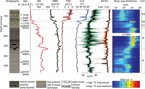
Fig. 3 Optical and radiographic images of selected sections showing the characteristics of the stratigraphic units.
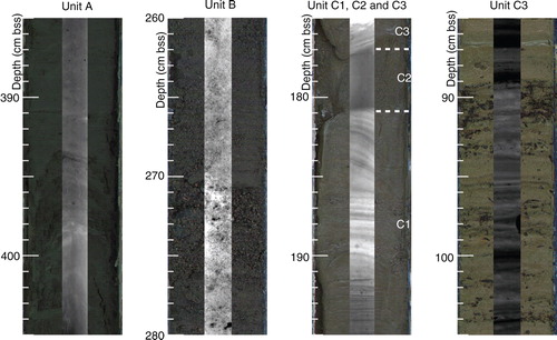
Unit B spans from 317 to 212 cm and is also dominated by minerogenic material. The matrix has a mainly dark grey colour with dark brownish parts (). The grain size is significantly coarser with alternating sand and gravel layers and some interspersed fine-grained intervals, likely a result of a more powerful and turbulent meltwater flow regime (, ). Sharp-edged, partly core-filling rocks of various composition and colours occur irregularly. The highest MS value of more than 400 (×10−5) SI units at around 317 cm coincides with the first occurrence of a rock fragment () in Unit B. Minor MS changes are not related to changes in WBD, TOC or water content, which are relatively constant throughout Unit B. Although the high-resolution Fe/Ti ratio shows large fluctuations, which may be artefacts due to increased surface roughness, the smoothed Fe/Ti ratio on the same level as in Unit A suggests either similar sediment origin or similar redox conditions. Changes in MS and WBD do not match the geochemical variations in Unit B. Grain size changes abruptly from well-sorted sand to poorly sorted silt at the upper boundary of Unit B (), which is an indication of a pronounced change towards vigorous sedimentation with a sediment source close to the lake.
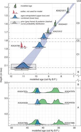
Fig. 4 Age–depth model showing calibrated and modelled ages with 2σ range (underlying bracket) and median (cross) of moss ages (green) plus extrapolation of unit boundaries and onset of biogenic productivity (blue) versus depth and units (k = 3.5, Amodel=98.6). The age of KIA34796 is considered an outlier (red) and the grey box indicates the prior probability distribution of 10–12 Ky B.P. Because of its event nature, the thickness of unit C2 has been subtracted prior to calculations. Linear sedimentation rates are 18.6 cm/Ky for the fine-laminated sediments of unit C1 and 16.6 cm/Ky in the lower part of unit C3.
Unit C extends from 212 cm to the top of the sequence and can be divided into three subunits. Subunit C1 spans from 212 to 181 cm and consists of laminated minerogenic sediment with a dark greyish brown to dark grey colour (). The sediment is soft and consists of silt to fine sand. The first remains of water mosses, chironomids, Chydorus arcticus and other fossils appear from 214 cm but their concentrations are very low and down-core transport during coring cannot be excluded (, ). Higher concentrations of fossils, particularly water mosses, chironomids and C. arcticus () between 190 and 185 cm depth, indicate increased biological productivity in the lake. MS and WBD further decrease, and TOC () and water content start to increase in Unit C1. Increasing Fe/Ti and decreasing Mn/Fe ratios occur with the appearance of organic remains and the decrease in grain size above 190 cm, indicating reducing conditions (Davies et al. Citation2015), an effect likely intensified by increased iron availability due to soil development in the catchment area or reduced surface run-off with less particulate titanium input.
Fig. 5 Selected part of the succession from Melles Lake showing bioproductivity indicators and grain size distribution compared with those from Duck Lake (central Store Koldewey) and environmental interpretation. Other fossils comprise Daphnia pulex, Lepidurus arcticus, Juncus sp., Luzula sp., Minuartia sp., Potentilla sp., Saxifraga oppositifolia, Draba sp., and Distichium sp. Ages are median of modelled ages, based on this study and Klug, Bennike et al. (Citation2009).
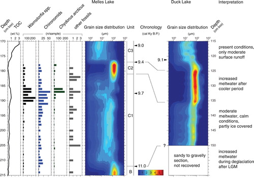
The horizon between 181 and 177 cm (Subunit C2) consists of well-sorted sand (), and the sediment is significantly more coarse-grained than in Unit C1. The clay to silt fraction, which dominates in Unit C1, is lacking. The lower and upper boundaries of Unit C2 are sharp in terms of grain size (). Low water and organic matter content and increased WBD () mirror the predominantly minerogenic and coarse-grained Subunit C2. The Fe/Ti ratio continues to increase.
Above 177 cm (Subunit C3), laminated clayey silt with abundant mosses above 173 cm is found (). The occurrence of macrofossils is also reflected by increased TOC content (Klug, Bennike et al. Citation2009), indicating better conditions for primary production. The colour depends on the density of moss and changes from dark olive grey to olive and greyish brown in more clastic layers (). The occurrence of mosses, partly identified as the aquatic species Warnstorfia exannulatus and Warnstorfia sarmentosum, varies with the highest concentrations around 150 cm and an overall decrease towards the top section of the record discussed in detail by Klug, Bennike et al. (Citation2009). Lower WBD and higher water content are typical for the sediments with increased TOC values in Subunit C3 ().
Chronology
The paired HA and HAF samples (here we discuss median ages in cal Ky B.P.; ) yielded, respectively, ages of 34.6 and 42.1 cal Ky B.P. for the lowermost part of Unit A (, ), ages of 39.9 and 35.4 cal Ky B.P. for the middle section and ages of 35.9 and 41.9 cal Ky B.P. for the upper part of Unit A (). The variable and partly large difference of up to 7.7 Ky between the HA and HAF fractions (KIA34798a and KIA34798b) shows that the HA and HAF ages are problematic. A common feature among the samples from Unit A is that the smallest fraction yielded the youngest ages regardless of the fraction type. With 0.75 to 0.8 mg carbon, they are slightly smaller than the suggested amount of 1 mg carbon for reliable 14C dating (P.M. Grootes, pers. comm. 2008). Samples KIA34798a, KIA34403b and KIA34797a overlap in time, with a youngest median age of 39.8 cal Ky B.P. at 3.675 m sediment depth. A modelled combination of these ages gave a time span of 42.2–40.7 cal Ky B.P. (median 41.5 cal Ky B.P.; , ). As a conservative approach, the youngest ages from Unit A can be interpreted as minimum ages, whereas the oldest ages provide a maximum age for the production of organic matter.
The 14C ages of the HA and HAF fractions from the lower part of Unit C1 are calibrated to 26.8 and 23.0 cal Ky B.P., respectively. These dates fall in the last glacial period when the Greenland Ice Sheet extended onto the east Greenland shelf (see Evans et al. Citation2009; Winkelmann et al. Citation2010). During this time period, the high- and lowlands of Store Koldewey were also ice-covered (Håkansson et al. Citation2007; Wagner et al. Citation2007; Klug, Schmidt et al. Citation2009). An ice cover emanating from the Greenland Ice Sheet covering the surrounding areas of Melles Lake and extending farther to the east onto the shelf during this time period makes formation and deposition of autochthonous organic matter in the lake unlikely. It is well known that radiocarbon dating of bulk samples of minerogenic lake sediments can give erroneous results. Reworking and re-deposition of sediment or soil that contains organic matter from previously living organisms can give anomalously old ages (Geirsdóttir et al. Citation2008), especially when using unidentified or finely dispersed organic material as in bulk sediment samples. For example, Olsson (Citation1979) showed that dating of Swedish sediments may yield too old ages on account of reworking of old carbon. Old carbon can also come from reworked interglacial or pre-glacial organic material such as fossils. In central east Greenland, radiocarbon dating of bulk sediment samples from a Holocene succession from lake Boksehandsken gave ages that were up to 10 000 years too old (Björck, Wohlfarth et al. Citation1994) as a result of reworked Mesozoic coal fragments and Eemian plant remains in the sediments. Based on the stratigraphic context with laminated sediment that excludes sedimentation of lower Unit C1 over several thousand years, we consider the two radiocarbon ages from lower C1 as likely to be contaminated with reworked old organic matter resulting in mixed ages not representing the true age of deposition. Klug, Bennike et al. (Citation2009) dated a moss sample from Subunit C1 (187–188 cm sediment depth, KIA34796) to 11.1 Ky B.P. The sample is from a distinct moss layer and undisturbed sediments as well as increased amounts of other fossils at the same level point to in situ preservation. Apart from one calibrated age of 11.2–10.8 cal Ky B.P. from a lake located at the outer coast ca. 150 km south of Store Koldewey (Bennike & Wagner Citation2012), the moss age (KIA34796) of 11.2–10.8 cal Ky B.P. (Klug, Bennike et al. Citation2009) predates the oldest regional existing radiocarbon ages by about 1.5 to 1.0 Ky (Wagner et al. Citation2007; Cremer et al. Citation2008; Klug, Schmidt et al. Citation2009).
The radiocarbon age of the moss sample from 187 to 188 cm depth (KIA34796) indicates that it originates from the beginning of the Holocene. The early Holocene was a time period when the recession of the Greenland Ice Sheet generated large amounts of meltwater (Fleming & Lambeck Citation2004; Simpson et al. Citation2009), and the lake basin likely was filled with glacial meltwater. In addition, the distinct laminae in Subunit C1 suggest deposition in a calm environment, such as a temporarily ice-covered lake. The ice cover could also partly account for limited CO2 lake-to-atmosphere exchange and lead to too old radiocarbon ages. Another source of too old ages could be glacial meltwater (Doran et al. Citation1999), especially from a proximal ice margin, which provides dissolved older carbon as CO2 into a proglacial lake basin where it may have been incorporated by algae and aquatic mosses during photosynthesis. Although Wolfe et al. (Citation2004) concluded that with longer water transport paths a sufficient CO2 atmosphere-to-lake-water exchange is provided, excess of dissolved “old” carbon from glacial melt may have overwhelmed the exchange rate of dissolved carbon with the atmosphere. Because of the close proximity of the meltwater source to the lake, we suggest that the age of the moss sample from 188 to 187 cm depth in proglacial Melles Lake may not represent the precise time of moss growth and hence deposition and formation of this section. An alternative approach is to model the age of the boundary between units B and C1 and the onset of biological productivity in Melles Lake. The modelling has the advantage that it recalculates the problematic ages in Unit C1 on the basis of the relatively uniform sedimentation as shown by undisturbed lamination. Modelling of the B–C1 boundary gave an age of 11.5–10.5 cal Ky B.P. (median 11.0 cal Ky B.P.; , ). This age plus the extrapolated age for the onset of biogenic productivity of 9.7 cal Ky B.P. is in good agreement with most other chronologies in north-east Greenland (Cremer et al. Citation2008).
Discussion
Fine-grained minerogenic sediments are known to form the basal part of many lacustrine records in east and north-east Greenland (Björck & Persson Citation1981; Björck, Bennike et al. Citation1994; Björck, Wohlfarth et al. Citation1994; Wagner et al. Citation2000; Klug, Schmidt et al. 2009). The closest described lake sediments with comparable characteristics with regard to lithostratigraphy, grain-size distribution and texture are situated some 40 km north of Melles Lake on central Store Koldewey (Wagner et al. Citation2007; Klug, Schmidt et al. 2009). Wagner et al. (Citation2007) suggested turbid glacial meltwater supply rather than aeolian or fluvial processes as origin for the occurrence of fine-grained clastic matter in Hjort Lake. Klug, Schmidt et al. (Citation2009) concluded that the basal minerogenic sediment in Duck Lake was most likely deposited in an aquatic environment, such as a proglacial lake, presumably after the LGM. The dating and modelling results of Unit A are, except for one non-finite 14C age from Duck Lake (Klug, Schmidt et al. Citation2009), significantly older than other ages reported from lake sediment records in north-east Greenland (Bennike & Björck Citation2002; Cremer et al. Citation2008).
The massive, almost homogeneous structure of Unit A in Melles Lake, with only indistinct layering, and the uniform distribution of radiocarbon ages over the entire unit indicate deposition over a short period rather than over thousands of years. The combined age of 41.5 cal Ky B.P. of three separate samples coincides with warmer conditions during MIS 3 (Johnsen et al. Citation1995) and may indicate that Unit A was deposited before the LGM, probably before the Greenland Ice Sheet overran the Melles Lake basin. However, there are no indications for an erosional unconformity in the entire sediment record as can be caused by warm-based glacier nor is Unit A compacted, which would be expected if the basin had been covered by cold-based ice. We therefore interpret that the combined age of 41.5 cal Ky B.P. represents an age of original organic matter formation, which was during a later glacier advance reworked by a growing Greenland Ice Sheet and finally deposited in the Melles Lake basin. Clear evidence—like identified organic matter for the potential sources—is missing, but one can assume that the material has been transported from sources in the west, that is, from Dove Bugt or from mainland Greenland. Other indicators for redeposition are the structural and textural characteristics of the basal fine-grained sediments in Unit A. Their homogeneity and the stratigraphic context of the basal part in Melles Lake show similarities with sediments formed from subglacial meltout (Brauer & Casanova Citation2001), but formation near an ice margin in association with a period of rapid ice decay, increased meltwater and fine-grained sediment supply into the freshly exposed basin (Ballantyne Citation2002) cannot be excluded. Taking the contrasting arguments of the proposed maximum age of Unit A and its sedimentological evidence into account, we find it more likely that Unit A was deposited during regional deglaciation when ice-free conditions were established on southern Store Koldewey at the end of the Pleistocene (Håkansson et al. Citation2007). Nevertheless, multiple ages of organic matter reaching back to ca. 41.5 cal Ky B.P. may imply ice-free conditions at least in the vicinity of Melles Lake during MIS 3 with favourable conditions for organic matter formation.
The interpretation of Unit A as a deposit of subglacial meltout is strengthened when considering the origin of the dominating coarse-grained sediments in Unit B, which indicate increased transport energy due to increased water supply. With its stratigraphic position above the basal fine-grained material, it may be argued that Unit B results from the decay of nearby ice or it formed due to increased meltwater that facilitated the transport of coarser sediments and flushed out most of the fine fraction. Glacial meltwater from a proximal ice margin during a period with rapidly increasing temperatures likely provided sufficient amount of meltwater. A period with temperatures increasing by about 5–10°C within some decades and a doubling of snow accumulation rates in central Greenland, which is necessary to facilitate such dynamic conditions, occurred at the Pleistocene–Holocene boundary (Alley Citation2000a, Citationb). The modelled age of ca. 11 cal Ky B.P. for the transition from coarse- to fine-grained sediments at the B–C1 boundary supports the assumption that Unit B was deposited in the early Holocene. The period of rather high-energy conditions was followed by a phase with lower fluxes of meltwater during which the finely laminated sediments in Unit C1 were deposited. This occurred when glaciers disappeared from the catchment area of the lake, leading to prevailing calm conditions similar to those at present. Prevailing calm conditions with clear water then promoted the colonization of the lake by plants and animals. The re-occurrence of coarse-grained and well-sorted minerogenic sediments of Unit C2 after the onset of biogenic productivity in Melles Lake indicates another episode of increasing meltwater input into the lake (). However, the sediment properties of the underlying sediments indicate that the lake catchment was already cleared of glacial ice; therefore, another source of increased water input is needed. Melting of remnants of glacial ice in the catchment as a source for rapidly increasing water flow is unlikely because any remnants are supposed to have been continuously disintegrating with increasingly higher temperatures during the early Holocene (Vinther et al. Citation2009). Even after a short cooler period, melting of ice remnants would continue with the same flux of meltwater. Evidence for readvancing glaciers as a potential source is not found in the vicinity of the lake and is also unknown from other areas in north-east Greenland (Vinther et al. Citation2009). We interpret Unit C2 as formed during a period with rapid melting of accumulated snow and increased sediment input after the cooler period recorded at 9.3 Kya in the Greenland ice cores and in a few lakes (Andresen et al. Citation2004; Rasmussen et al. Citation2007; Young et al. Citation2011). This is corroborated by increased snow accumulation in the Renland Ice Cap core (Johnsen et al. Citation1992; Vinther et al. Citation2008) and a similar sediment event found in Duck Lake on Store Koldewey (; Klug, Schmidt et al. Citation2009). A potential alternative interpretation of Unit C2 is that it was formed by a slump triggered by rapid melting after the 9.3 Kya cold event. Similar sediments are not recorded in Hjort Lake (Wagner et al. Citation2007), but this could be a result of a different catchment configuration. Following this episode of coarser sedimentation, silty to clayey laminated sediments dominate again (, ), indicating the re-establishment of calm sedimentation conditions in Melles Lake. The remaining Holocene history of the lake is characterized by varying biogenic productivity that primarily mirrors the local and regional climatic history (Klug, Bennike et al. Citation2009). They attributed lower TOC content and variable moss occurrences to repeated unfavourable conditions as promoted by variable and especially lower temperatures and variable lake ice coverage. Evidence of advancing glaciers during the neoglaciation or the Little Ice Age is not seen in the sediment record from Melles Lake.
Summary and conclusions
In summary, we suggest that the sedimentary units of the lacustrine record document a succession from a proglacial lake to present conditions with increasing distance to the ice margin and a response to Holocene climatic variations. On the basis of sediment properties such as lamination, the successive deposition of the sedimentary units without evidence of hiatuses or erosion, combined with age modelling, we conclude that the basin became ice-free at the Pleistocene–Holocene transition or shortly thereafter. AMS 14C dating of bulk sediment samples from the lower part of the lake sediment record yielded ages of 43–33 cal Ky B.P., clearly predating the LGM. These ages are most likely caused by reworking of old carbon from the lake catchment and do not reflect the time of deposition of the sediments. The ages may, however, indicate that ice-free areas with favourable condition for organic matter production existed during MIS 3. Although we cannot provide firm dating of Units A and B, we conclude that deposition of the lower part of the sediment succession in Melles Lake occurred after the LGM following the local deglaciation, probably in the beginning of the Holocene. The record from Melles Lake indicates that southern Store Koldewey in contrast to previous suggestions of ice-free condition during the LGM by Hjort (Citation1981) was likely covered by ice. We did not find evidence to show whether the ice cover was a local ice cap or part of the Greenland Ice Sheet, in accordance with conclusions by Håkansson et al. (Citation2007). However, given the growing number of studies that confirm an ice extent of the Greenland Ice Sheet in north-east Greenland beyond the present coast (Evans et al. Citation2009; Winkelmann et al. Citation2010), it is most likely that also Store Koldewey was overrun by the Greenland Ice Sheet. The overall homogeneity of the basal sediments indicates that Units A and B were deposited over a short time span, likely during some decades or centuries and presumably during rapid local ice decay on Store Koldewey. The post-deglacial environmental history of Store Koldewey indicates that coastal areas of north-east Greenland were also affected by climatic oscillations and pronounced environmental changes during the 9.3 Kya cold event.
Acknowledgements
MK's research was financed by the German Research Foundation (grant no. ME 1169/10). The authors specially thank the field team on Store Koldewey in 2003 and the crew of the R/V Polarstern for logistical support. The authors express their thanks to Hans Hubberten (Alfred Wegener Institute, Potsdam) and Werner Ehrmann (University of Leipzig) for authorizing access to analytical devices and Christian Hjort (Lund University) and Nicolaj K. Larsen (Aarhus University) for their helpful discussions. The authors also thank Willem van der Bilt and the anonymous reviewers for constructive comments that helped improve the manuscript.
Related Research Data
References
- Aitchison J. The statistical analysis of compositional data. 1986; New York: Chapman and Hall.
- Alley R.B. The Younger Dryas cold interval as viewed from central Greenland. Quaternary Science Reviews. 2000a; 19: 213–226.
- Alley R.B. Ice-core evidence of abrupt climate changes. Proceedings of the National Academy of Sciences of the United States of America. 2000b; 97: 1331–1334.
- Andresen C.S., Björck S., Bennike O., Bond G. Holocene climate changes in southern Greenland: evidence from lake sediments. Journal of Quaternary Science. 2004; 19: 783–795.
- Aufgebauer A., Panagiotopoulos K., Wagner B., Schaebitz F., Viehberg F.A., Vogel H., Zanchetta G., Sulpizio R., Leng M.J., Damaschke M. Climate and environmental change in the Balkans over the last 17 ka recorded in sediments from Lake Prespa (Albania/F.Y.R. of Macedonia/Greece). Quaternary International. 2012; 274: 122–135.
- Ballantyne C.K. Paraglacial geomorphology. Quaternary Science Reviews. 2002; 21: 1935–2017.
- Bennike O., Björck S. Chronology of the last recession of the Greenland Ice Sheet. Journal of Quaternary Science. 2002; 17: 211–219.
- Bennike O., Cremer H., Håkansson L., Hultzsch N., Klug M., Kobabe S., Wagner B. Jokat W. Quaternary geological and biological studies on Store Koldewey and on Geographical Society Ø. The expedition Arktis XIX/4 of the research vessel Polarstern in 2003. Reports of Legs 4a and 4b. 2004; Bremerhaven: Alfred Wegener Institute for Polar and Marine Research. 51–74.
- Bennike O., Knudsen K.L., Abrahamsen N., Böcher J., Cremer H., Wagner B. Early Pleistocene sediments on Store Koldewey, northeast Greenland. Boreas. 2010; 39: 603–619.
- Bennike O., Wagner B. Deglaciation chronology, sea-level changes and environmental changes from Holocene lake sediments of Germania Havn Sø, Sabine Ø, northeast Greenland. Quaternary Research. 2012; 78: 103–109.
- Björck S., Bennike O., Ingolfsson O., Barnekow L., Penney D.N. Lake Boksehandsken's earliest postglacial sediments and their palaeoenvironmental implications, Jameson Land, East Greenland. Boreas. 1994; 23: 459–472.
- Björck S., Persson T. Late Weichselian and Flandrian biostratigraphy and chronology from Hochstetter Forland, northeast Greenland. Meddelelser om Greenland, Geoscience. 1981; 5: 3–18.
- Björck S., Rundgren M., Ingolfsson O., Funder S. The Preboreal oscillation around the Nordic Seas: terrestrial and lacustrine responses. Journal of Quaternary Science. 1997; 12: 455–465.
- Björck S., Wohlfarth B., Bennike O., Hjort C., Persson T. Revision of the early Holocene Lake Sediment based chronology and event stratigraphy on Hochstetter Forland, NE Greenland. Boreas. 1994; 23: 513–523.
- Brauer A., Casanova J. Chronology and depositional processes of the laminated sediment record from Lac d'Annecy, French Alps. Journal of Paleolimnology. 2001; 25: 163–177.
- Bronk Ramsey C. Bayesian analysis of radiocarbon dates. Radiocarbon. 2009; 51: 337–360.
- Bronk Ramsey C.B. Deposition models for chronological records. Quaternary Science Reviews. 2008; 27: 42–60.
- Cappelen J., Jorgensen B.V., Laursen E.V., Stannius L.S., Thomsen R.S. The observed climate of Greenland, 1958–99: with climatological standard normals, 1961–90. Technical Report 00–18. 2001; Copenhagen: Danish Meteorological Institute.
- Cremer H., Bennike O., Håkansson L., Hultzsch N., Klug M., Kobabe S., Wagner B. Hydrology and diatom phytoplankton of High Arctic lakes and ponds on Store Koldewey, northeast Greenland. International Review of Hydrobiology. 2005; 90: 84–99.
- Cremer H., Bennike O., Wagner B. Lake sediment evidence for the last deglaciation of eastern Greenland. Quaternary Science Reviews. 2008; 27: 312–319.
- Croudace I.W., Rindby A., Rothwell R.G. Itrax: description and evaluation of a new multi-function x-ray core scanner. Special Publication Geological Society of London. 2006; 267: 51.
- Davies S.J., Lamb H.F., Roberts S.J. Rothwell R.G., Croudace I.W. Micro-XRF core scanning in palaeolimnology: recent developments. Micro-XRF studies of sediment cores. 2015; Dordrecht: Springer. 189–226.
- Doran P.T., Berger G.W., Lyons W.B., Wharton R.A. Jr., Davisson M.L., Southon J., Dibb J.E. Dating quaternary lacustrine sediments in the McMurdo Dry Valleys, Antarctica. Palaeogeography, Palaeoclimatology, Palaeoecology. 1999; 147: 223–239.
- Escher J.C., Pulvertaft T.C.R. Geological map of Greenland, 1:2 500 000. 1995; Copenhagen: Geological Survey of Greenland.
- Evans J., Ó Cofaigh C., Dowdeswell J.A., Wadhams P. Marine geophysical evidence for former expansion and flow of the Greenland Ice Sheet across the north-east Greenland continental shelf. Journal of Quaternary Science. 2009; 24: 279–293.
- Fleming K., Lambeck K. Constraints on the Greenland Ice Sheet since the Last Glacial Maximum from sea-level observations and glacial-rebound models. Quaternary Science Reviews. 2004; 23: 1053–1077.
- Fredin O., Rubensdotter L. 3D plot of grain size data in sedimentology. 2011. Accessed on the internet at http://www.mathworks.com/ on 25 October 2011.
- Funder S. Fulton R.J. Development of climate, glaciation, and oceanographic circulation (Greenland). Quaternary geology of Canada and Greenland. 1989; Ottawa: Geological Survey of Canada. 783–786.
- Funder S., Hansen L. The Greenland Ice Sheet—a model for its culmination and decay during and after the last glacial maximum. Bulletin of the Geological Society of Denmark. 1996; 42: 137–152.
- Funder S., Hjort C., Landvik J.Y. The last glacial cycles in East Greenland, an overview. Boreas. 1994; 23: 283–293.
- Funder S., Hjort C., Landvik J.Y., Nam S.I., Reeh N., Stein R. History of a stable ice margin—East Greenland during the middle and upper Pleistocene. Quaternary Science Reviews. 1998; 17: 77–123.
- Funder S., Kjeldsen K.K., Kjær K.H., Ó Cofaigh C. Ehlers J. The Greenland Ice Sheet during the past 300,000 years: a review. Quaternary glaciations—extent and chronology. A closer look. 2011; Amsterdam: Elsevier. 699–713.
- Geirsdóttir Á., Miller G.H., Thordarson T., Ólafsdóttir K.B. A 2000 year record of climate variations reconstructed from Haukadalsvatn, west Iceland. Journal of Paleolimnology. 2008; 41: 95–115.
- Grootes P.M., Nadeau M.J., Rieck A. 14C-AMS at the Leibniz-Laboratory: radiometric dating and isotope research. Nuclear Instruments and Methods in Physics Research B. 2004; 223: 55–61.
- Håkansson L., Graf A., Strasky S., Ivy-Ochs S., Kubik P.W., Hjort C., Schlüchter C. Cosmogenic 10Be-ages from Store Koldewey island, NE Greenland. Geografiska Annaler Series A. 2007; 89: 195–202.
- Hansen L.A., Rogensen M.E., Houmark-Nielsen M., Kronborg C. Late Pleistocene stratigraphy and depositional environments of the Fynselv area, Jameson Land, East Greenland. Boreas. 1994; 23: 385–397.
- Henriksen M., Higgins A.K., Kalsbeck F., Pulvertaft T.C.R. Greenland from Archaean to Quaternary, descriptive text to the geological maps of Greenland 1: 2 500 000. Geology of Greenland Survey Bulletin 185. 2000; Copenhagen: Geological Survey of Denmark and Greenland.
- Hjort C. Glaciation in northern East Greenland during the Late Weichselian and Early Flandrian. Boreas. 1979; 8: 281–296.
- Hjort C. A glacial chronology for northern East Greenland. Boreas. 1981; 10: 259–274.
- Hjort C., Björck S. A re-evaluated glacial chronology for northern east Greenland. Geologiska Föreningens i Stockholm Förhandlingar. 1984; 105: 235–243.
- Houmark-Nielsen M., Hansen L., Jørgensen M.E., Kronborg C. Stratigraphy of a late Pleistocene ice-cored moraine at Kap Herschell, northeast Greenland. Boreas. 1994; 23: 505–512.
- Johnsen S.J., Clausen H.B., Dansgaard W., Hansson M., Jonsson P., Steffensen J.P., Sveinbjørnsdottir A.E. A deep ice core from east Greenland. Meddelelser om Grønland, Geoscience 29. 1992; , Copenhagen: C.A. Reitzel.
- Johnsen S.J., Dahl-Jensen D., Dansgaard W., Gundestrup N. Greenland palaeotemperatures derived from GRIP bore hole temperature and ice core isotope profiles. Tellus B. 1995; 47: 624–629.
- Kelly M.A., Lowell T.V., Hall B.L., Schaefer J.M., Finkel R.C., Goehring B.M., Alley R.B., Denton G.H. A 10Be chronology of lateglacial and Holocene mountain glaciation in the Scoresby Sund region, east Greenland: implications for seasonality during lateglacial time. Quaternary Science Reviews. 2008; 27: 2273–2282.
- Klug M., Bennike O., Wagner B. Repeated short-term bioproductivity changes in a coastal lake on Store Koldewey, northeast Greenland: an indicator of varying sea-ice coverage?. The Holocene. 2009; 19: 653–663.
- Klug M., Schmidt S., Bennike O., Heiri O., Melles M., Wagner B. Lake sediments from Store Koldewey, northeast Greenland, as archive of late Pleistocene and Holocene climatic and environmental changes. Boreas. 2009; 38: 59–71.
- Koinig K.A., Shotyk W., Lotter A.F., Ohlendorf C., Sturm M. 9000 years of geochemical evolution of lithogenic major and trace elements in the sediment of an alpine lake—the role of climate, vegetation, and land-use history. Journal of Paleolimnology. 2003; 30: 307–320.
- Landvik J.Y. The last glaciation of Germania Land and adjacent areas, northeast Greenland. Journal of Quaternary Science. 1994; 9: 81–92.
- Landvik J.Y., Lyså A., Funder S., Kelly M. The Eemian and Weichselian stratigraphy of the Langelandselv area, Jameson Land, East Greenland. Boreas. 1994; 23: 412–423.
- Melles M., Brigham-Grette J., Minyuk P.S., Nowaczyk N.R., Wennrich V., DeConto R.M., Anderson P.M., Andreev A.A., Coletti A., Cook T.L., Haltia-Hovi E., Kukkonen M., Lozhkin A.V., Rosén P., Tarasov P., Vogel H., Wagner B. 2.8 million years of Arctic climate change from Lake El'gygytgyn, NE Russia. Science. 2012; 337: 315–320.
- Melles M., Kulbe T., Overduin P.P., Verkulich S., Melles M., The expedition Bunger Oasis 1993/94 of the AWI Research Unit Potsdam . The expeditions Norilsk/Taymyr 1993 and Bunger Oasis 1993/94 of the AWI Research Unit Potsdam. Berichte fur Polarforschung 148, 29–80 . 1994
- Olsson I. A warning against radiocarbon dating of samples containing little carbon. Boreas. 1979; 8: 203–207.
- Rasmussen S.O., Vinther B.M., Clausen H.B., Andersen K.K. Early Holocene climate oscillations recorded in three Greenland ice cores. Quaternary Science Reviews. 2007; 26: 1907–1914.
- Reimer P.J., Baillie M.G., Bard E., Bayliss A., Beck J.W., Blackwell P.G., Ramsey C.B., Buck C.E., Burr G.S., Edwards R.L., Friedrich M., Grootes P.M., Guilderson T.P., Hajdas I., Heaton T.J., Hogg A.G., Hughen K.A., Kaiser K.F., Kromer B., McCormac F.G., Manning S.W., Reimer R.W., Richards D.A., Southon J.R., Talamo S., Turney C.S.M., van der Plicht J., Weyhenmeye C.E. IntCal09 and Marine09 radiocarbon age calibration curves, 0–50,000 years cal BP. Radiocarbon. 2009; 51: 1111–1150.
- Richter T.O., Van der Gaast S., Koster B., Vaars A., Gieles R., De Stigter H.C., De Haas H., Van Weering T.C.E. Rothwell R.G. The Avaatech XRF core scanner: technical description and applications to NE Atlantic sediments. New techniques in sediment core analysis. Geological Society, London, Special Publications 267. 2006; London: Geological Society. 39–50.
- Simpson M.J.R., Milne G.A., Huybrechts P., Long A.J. Calibrating a glaciological model of the Greenland ice sheet from the Last Glacial Maximum to present-day using field observations of relative sea level and ice extent. Quaternary Science Reviews. 2009; 28: 1631–1657.
- Vinther B.M., Buchardt S.L., Clausen H.B., Dahl-Jensen D., Johnsen S.J., Fisher D.A., Koerner R.M., Raynaud D., Lipenkov V., Andersen K.K., Blunier T., Rasmussen S.O., Steffensen J.P., Svensson A.M. Holocene thinning of the Greenland ice sheet. Nature. 2009; 461: 385–388.
- Vinther B.M., Clausen H.B., Fisher D.A., Koerner R.M., Johnsen S.J., Andersen K.K., Dahl-Jensen D., Rasmussen S.O., Steffensen J.P., Svensson A.M. Synchronizing ice cores from the Renland and Agassiz ice caps to the Greenland ice core chronology. Journal of Geophysical Research—Atmospheres. 2008; 113: D08115,. doi: http://dx.doi.org/10.1029/2007JD009143.
- Wagner B., Bennike O., Bos J.A.A., Cremer H., Lotter A.F., Melles M. A multidisciplinary study of Holocene sediment records from Hjort Sø on Store Koldewey, northeast Greenland. Journal of Paleolimnology. 2007; 39: 381–398.
- Wagner B., Bennike O., Cremer H., Klug M. Late quaternary history of the Kap Mackenzie area, northeast Greenland. Boreas. 2010; 39: 492–504.
- Wagner B., Melles M., Hahne J., Niessen F., Hubberten H.W. Holocene climate history of Geographical Society Ø, East Greenland—evidence from lake sediments. Palaeogeography, Palaeoclimatology, Palaeoecology. 2000; 160: 45–68.
- Weber M.E., Niessen F., Kuhn G., Wiedicke M. Calibration and application of marine sedimentary physical properties using a multi-sensor core logger. Marine Geology. 1997; 136: 151–172.
- Wersin P., Höhener P., Giovanoli R., Stumm W. Early diagenetic influences on iron transformations in a freshwater lake sediment. Chemical Geology. 1991; 90: 233–252.
- Winkelmann D., Jokat W., Jensen L., Schenke H.W. Submarine end moraines on the continental shelf off NE Greenland—implications for lateglacial dynamics. Quaternary Science Reviews. 2010; 29: 1069–1077.
- Wolfe A.P., Miller G.H., Olsen C.A., Forman S.L., Doran P.T., Holmgren S.U. Pienitz R. Geochronology of high latitude lake sediments. Long-term environmental change in Arctic and Antarctic lakes. Vol. 8. 2004; Dordrecht: Springer. 19–52.
- Young N.E., Briner J.P., Axford Y., Csatho B., Babonis G.S., Rood D.H., Finkel R.C. Response of a marine—terminating Greenland outlet glacier to abrupt cooling 8200 and 9300 years ago. Geophysical Research Letters. 2011; 38: L24701,. doi: http://dx.doi.org/10.1029/2011GL049639.