Abstract
Background: Countries interested in monitoring and quantifying the carbon stock of their tropical forests need cost-effective methodologies to map aboveground carbon density (ACD) at regional and national project levels, and with measurable precision and accuracy. This study reports on improvements made possible by the use of airborne high resolution LiDAR samples to regionally fine-tune freely available moderate resolution remote sensing data, and generate maps of ACD with greater detail and improved accuracy than existing pantropical data sets. Results: Regions in the Peruvian and Colombian Amazon indicate that, although existing pantropical data sets of ACD explain approximately 70% of the variance in ACD relative to high resolution LiDAR estimates, by fine calibration with airborne LiDAR samples, it is possible to reduce the relative root mean squared error from 25.2 and 31.4 MgC ha-1, to 15.7 and 17.6 MgC ha-1, respectively, in Colombia and Peru. Conclusion: Airborne LiDAR data can successfully be used for fine-tuning freely available moderate resolution remote sensing image data and significantly improving existing aboveground carbon density maps, to better meet the requirements for national and subnationl carbon density mapping.
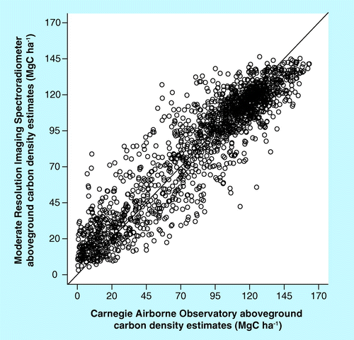
The model explains 86% of the variance in biomass density with a root mean squared error = 16.5 MgC ha-1.
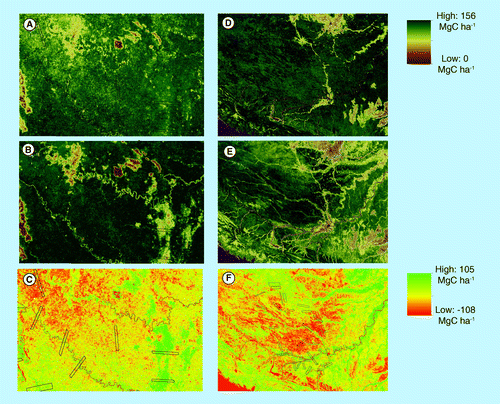
Subset maps of ACD derived from pantropical mapping of (A) Colombia and (D) Peru, then (B) and (E) remapped after fine-tuning with CAO LiDAR data. The difference between the two maps is shown in panels (C) and (F). A subset of the CAO samples are shown in black lines.
ACD: Aboveground carbon density; CAO: Carnegie Airborne Observatory.
Each point in the figure shows the average CAO ACD within the Moderate Resolution Imaging Spectroradiometer pixel versus the ACD derived from the pantropical data set after removing 50 MgC ha-1 bias due to allometry.
ACD: Aboveground carbon density; CAO: Carnegie Airborne Observatory.
Here we consider each flight block as one observation.
Global tropical forests store approximately 228 billion metric tons of carbon in aboveground live tissues, and are a source of CO2 through deforestation and degradation that currently equals or exceeds total transportation sector emissions worldwide Citation[1]. As a result, there has been a rapid increase in efforts to conserve tropical forest carbon stocks as a contribution to stabilizing atmospheric CO2 concentrations Citation[2]. One of the key initiatives supporting tropical forest carbon conservation is known as REDD+ Citation[3].
To make REDD+ a possibility as a natural resource and international climate mitigation policy tool, the amount of carbon (approximately 48% of biomass by dry weight Citation[4]) stored in forests must be repeatedly mapped and spatially monitored. In response to this need, remote sensing has taken on a role, along with new and pre-existing field plot inventory networks, in developing maps of aboveground carbon density (ACD); in units of MgC ha-1. At the pantropical scale, two particular approaches using satellite data have been put forward to enhance our understanding of ACD distributions Citation[5,6]. Both approaches utilize moderate resolution, global satellite information with field data to estimate tropical forest carbon stocks. The gridded spatial resolution of these approaches ranges from 500 to 1000 m, and the uncertainties reported on any given grid cell range from 10 to more than 100%, in other words, the uncertainty of the globally mapped ACD values within any given grid cell can be as large as the value reported.
While global-scale carbon mapping approaches have advanced the readiness of the international community for REDD+ and similar partnership programs, much of the activity to reduce tropical carbon losses is advancing at national and subnational scales Citation[7]. To support these activities, other work combining higher resolution satellite, airborne LiDAR and field plot data has focused on developing maps at grid cell resolutions of 30–100 m Citation[8–10]. At 1-ha mapping resolution, uncertainties in mapped carbon stocks based on the LiDAR approach are 10–20% Citation[11,12], which is the critical level of accuracy supporting jurisdictional carbon accounting Citation[13]. A current drawback with this approach, however, rests on the fact that fairly high spatial resolution satellite data – such as from Landsat sensors – is required, and these data are not available for all tropical regions, owing to persistent cloud cover Citation[14].
On the one hand, the global carbon mapping approaches provide near wall-to-wall coverage of the tropics, but their accuracy is necessarily lowered by their limited sensitivity to vertical forest structures. While regional- to national-scale carbon mapping approaches provide high-resolution results with higher per-hectare accuracies, they are difficult to implement worldwide. We therefore seek to combine the best aspects of these two approaches by leveraging the global satellite coverage from the former method with the high precision airborne LiDAR-based ACD estimates of the latter approach. The benefit would be bi-directional: global maps can be improved on a region by region basis to better quantify global carbon stocks, and regional maps can be derived from the global data sets but with higher accuracy than that achieved by the original global mapping approach.
Here, we report on the first study to fine-tune a pantropical carbon map to specific subnational regions, using freely available global satellite data with regionally sampled areas of forest structure from airborne LiDAR. We carried out the study in two regions of the Amazon basin, one in Colombia and one in Peru, to estimate the improved per-hectare accuracies achieved using the downscaling methodology presented.
Methods & materials
▪ Study area
The two study regions were defined in previous reports by Asner et al. in the southern Peruvian Amazon Citation[8] and in the Colombian Amazon Citation[9]. The Peru study area encompasses 4.3 Mha of forest in the department of Madre de Dios. The region is lowland humid tropical forest with a rapidly expanded land-use change process involving cattle ranching, agriculture and gold mining. The Colombia study area covers 16.5 Mha of lowland Amazonian forest with relatively little land-use change; however, the region contains widely varying carbon stocks based on floodplain inundation and other hydrological processes. The Colombia study covers the government’s REDD+ demonstration and research region. Together, the Peru and Colombia regions harbor a wide range of carbon stock levels matching the range found throughout the pantropics.
▪ Airborne LiDAR
In both the Peru and Colombia study regions, LiDAR data were collected using the Carnegie Airborne Observatory (CAO) Alpha Sensor Package Citation[10]. The CAO LiDAR was capable of both full waveform and discrete return measurements, but for this study only the data from the discrete return data were used, as described in detail by Asner et al.Citation[8,9]. In Peru, the data were collected in 31 sampling blocks randomly distributed throughout the region. These sampling blocks ranged in size from approximately 800 to 22,000 ha per block, and total LiDAR coverage for Peru was 304,758 ha within the 4.3 Mha mapping region. In Colombia, the data were acquired in 39 sampling blocks, also randomly distributed throughout the region. The blocks ranged in size from approximately 3700 to 28,000 ha, for a total LiDAR coverage of 465,622 ha. Details of the LiDAR instrument settings, data collection protocol and processing steps were previously detailed by Asner et al.Citation[8,9]. Briefly, the data were collected from 2000 m above ground-level in sampling blocks with 50% overlap among adjacent flightlines. This resulted in a laser spot density of approximately two laser shots m-2. The data were processed to laser point clouds, and then classified to derive digital terrain models and digital surface models. Mean canopy profile height (MCH) – a commonly used LiDAR metric measuring the distance from ground (digital terrain models) to the approximate centroid of the tree crowns Citation[15] – was mapped at 1.1 m spatial resolution.
The MCH maps were calibrated to field-estimated ACD values from plot inventory networks described by Asner et al.Citation[16], and 30 m resolution ACD maps were derived for each LiDAR sampling block. Heavily documented previously Citation[8,9,16], we provide a summary here of the method. First, 0.28 ha circular plots were established in the study regions, placed randomly in areas to capture the full range of aboveground carbon stock levels, and among a wide range of vegetation types and disturbance conditions. The median value of the MCH in each plot was computed from the CAO LiDAR data. Regressions were developed between plot-level median MCH and estimated ACD. The regression was then applied to LiDAR-based maps of median MCH at 30 m resolution.
▪ Moderate Resolution Imaging Spectroradiometer data
We used canopy reflectance data produced from the Moderate Resolution Imaging Spectroradiometer (MODIS) sensors onboard the NASA TERRA and AQUA satellites. The 500 m spatial resolution MODIS reflectance measurements were screened for cloud cover, normalized for viewing and solar conditions and composited to an 8-day time interval Citation[15,17]. This MODIS product assures the largest number of observations of the highest possible data quality. We further screened the reflectance data set to include only those solutions that make use of at least three observations within two 8-day time periods, taking the approach of using only the highest quality data results in an image product with a substantial number of spatial data gaps. To overcome this limitation, we used MODIS Nadir Bidirectional Reflectance Distribution Function-Adjusted Reflectance MCD43A4 and MCD43A1 data spanning 2 years (2007–2008), including a total of 92 sensor observations Citation[18]. Although, for the regions of this study, a 1-year window was sufficient to produce a cloud-free mosaic, for consistency with results reported previously Citation[6], we used the 2-year time window. In addition to the pixel mean, we created a layer for the SD, Enhanced Vegetation Index and Normalized Difference Infrared Index vegetation indices Citation[19]. For the same observations, the MODIS Land Surface Temperature (LST) was extracted and the average values were computed. NASA Shuttle Radar Topography Mission data at a resolution of 90 m were aggregated to the resolution of 500 m MODIS reflectance. The following variables were used to develop a RandomForest model that generates estimates of ACD in each MODIS pixel Citation[20]:
▪ Band 1 (red) 630–690 nm; | |||||
▪ Band 2 (near-infrared) 780–900 nm; | |||||
▪ Band 4 (green) 530–610 nm; | |||||
▪ Band 5 (near-infrared) 1230–1250 nm; | |||||
▪ Band 6 (mid infrared) 1550–1750 nm; | |||||
▪ Band 7 (mid infrared) 2090–2350 nm; | |||||
▪ Variance in band 7; | |||||
▪ LST and variance in LST; | |||||
▪ Enhanced Vegetation Index (EVI2); | |||||
▪ Normalized Difference Infrared Index (NDII2); | |||||
▪ Elevation from Shuttle Radar Topography Mission. | |||||
The remaining steps for this processing were detailed by Baccini et al.Citation[6].
▪ Analysis
Approach airborne LiDAR assisted mapping at large scales
Following the general approach of Baccini et al.Citation[6], field protocols were developed to collect biometric data for tree stems located within Geoscience Laser Altimeter System (GLAS) footprints over broad geographical scales, and allometric relationships were used to estimate aboveground biomass density within those footprints Citation[21]. Using these data, linear models were estimated to predict biomass within GLAS footprints based on GLAS LiDAR metrics. This relationship was then used to predict biomass at several thousand high-quality GLAS footprints distributed across the tropics. By intersecting the location of this sample with 500-m MODIS pixels, we identified locations where multiple GLAS footprints were available within MODIS pixels and used these to calibrate a machine learning model (RandomForest; Citation[20]) that predicts biomass based on MODIS data. This model was then used to generate a wall-to-wall map of pantropical aboveground biomass from MODIS.
In this article, we replaced the GLAS data with the CAO high resolution LiDAR ACD estimates to calibrate a RandomForest algorithm Citation[20,22]. RandomForest is a data mining algorithm that performs recursive partitioning of the data and uses different bootstraps samples to estimate a large number of tree-based models, resulting in more accurate and less sensitive to noise data sets. This approach generates a continuous range of ACD estimates for each grid cell of the data set described in the previous section. To do this, we first projected the CAO ACD in the MODIS Sinusoidal original projection and computed the average ACD within each of the 500 m grid cells overlapping with the CAO transects. The cells overlapping for at least 95% of the area were used as a training data set in the RandomForest algorithm. We assessed the results by cross-validation analysis, in which we set aside 10% of the data to test the RandomForest estimates versus the original CAO ACD estimates.
Comparison of moderate & high resolution ACD
We assessed potential improvements achieved in the new, regionally tuned carbon stocks estimates based on CAO ACD data (CACD) relative to the previously available moderate resolution data set, referred to here as the pantropical ACD (PACD). For each 500 m PACD cell overlapping with CACD sampling blocks (not including edges of dual coverage), we computed the average CACD carbon stocks. We also computed the average CACD for each flight block and compared it to the average carbon stocks derived from the 500 m PACD. We used the root mean squared error (RMSE) between CACD and PACD to quantify statistical goodness of fit.
Results
▪ New approach
The new, regionally tuned models calibrated using the CACD successfully estimated ACD with a RMSE of 15.7 and 17.6 Mg ha-1 in Colombia and Peru, respectively, and explained approximately 86% of the variance in ACD . The advantage of using CACD was threefold:
▪ The high sensitivity of the CAO instrument to forest structure provided a more accurate link to carbon stocks than the large footprint spaceborne GLAS sensor did Citation[23]; | |||||
▪ The 30 m spatial resolution of CACD provided wall-to-wall coverage of specific 500 m MODIS pixels, overcoming the limitations of sampling sensors such as GLAS that provide forest structural measurements for only few limited areas within MODIS pixels; | |||||
▪ It provided a much larger training data set for the calibration of the model to the specific study region of interest. | |||||
There were 18,176 CAO training samples for Colombia and 12,137 for Peru. These factors led to an overall improved calibration of the optical satellite data to forest structure, particularly in pixels with a mosaic of land cover types Citation[24].
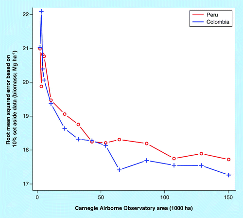
The results indicated that a relatively limited coverage of CAO-derived carbon stock estimates, for example 30% (or ˜150,000 ha) of randomly selected CAO data, significantly improved regional carbon stocks estimates by reducing the overall RMSE . Spatially, the new regionally tuned model provided a more detailed characterization of the ACD distribution over the study region, revealing clearer spatial patterns in carbon stocks than that achieved using the original pantropical approach based on spaceborne GLAS LiDAR data . The inferior performance of the GLAS-based approach is the result of sensor characteristics such as the large and variable footprint (˜60–75 m), the limited number of GLAS shots in the study region (after filtering Citation[6]) and the lack of field data available in the calibration process. In contrast, the airborne LiDAR data have a small and constant foot print of 1.1 m in this case, are derived from high-power laser emissions that yield detailed vertical structural information on the canopy and are well calibrated to field plots.
▪ Comparison of PACD & CACD maps
A comparison of the original PACD and CACD maps revealed a general agreement between the two data sets, but important region-specific discrepancies were noted as well. Foremost, the PACD values tended to be higher than the CACD results, indicating a bias of approximately 50 MgC ha-1 in the PACD. We found that this discrepancy resulted from different allometric equations used to develop plot estimates of ACD in previous studies by Baccini et al.Citation[6] and Asner et al.Citation[8,9]. The CAO-based studies had used allometric equations incorporating both stem diameters and canopy height, while the PACD study used allometry based only on stem diameter Citation[21]. These findings are consistent with Feldpausch et al., reporting that in the Amazon basin, the use of the tree height in the allometric equations results in lower estimates than allometry with only stem diameter Citation[25]. A simple offset correction addressed this issue, but we emphasis here the importance of allometric models and the potential errors embedded in the construction of those models Citation[26].
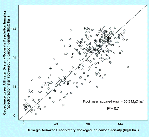
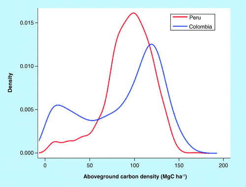
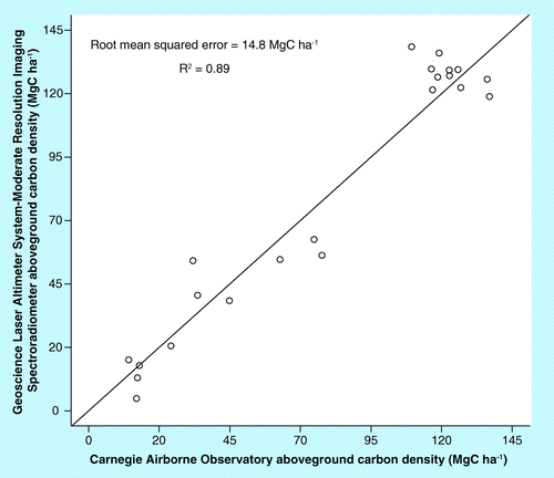
Overall, the pixel-level comparison of original PACD and CACD data indicated general agreement, with PACD explaining approximately 70% of the variance relative to CACD . We observed that the ACD distribution in the Peru and Colombia study areas had a similar range, but with a different frequency distribution with Colombia . Colombia showed a binomial distribution, whereas Peru had the majority of carbon stocks values between 80 and 120 Mg ha-1. The lower variability of carbon stocks in the Peru data set likely approaches the limit in how well the PACD data set captures small local variability in ACD, thereby explaining the observed larger relative RMSE . At the regional level, the comparison of PACD versus CACD aggregated at the flight sampling block (thousands of ha) indicated very good agreement, with a relative RMSE of 14.8 Mg ha-1 and R2 = 0.89 .
The comparison of the new regionally tuned PACD and CACD maps indicated a more consistent agreement between the two maps, with the new PACD explaining up to 86% of the variance relative to CACD . Furthermore, because the ACD data used in the calibration of the new model was based on allometry consistent with CACD, the previously observed allometry-based bias was now solved.
Discussion
By leveraging the capabilities of high-resolution airborne LiDAR ACD estimates, which are very accurate but limited in spatial coverage, with coarser resolution satellite observations, we are able to model carbon stocks over large areas with demonstrable precision. Here, we show how freely available, global data such as from MODIS, when calibrated with CAO-estimated ACD sampling blocks, can improve carbon stock maps in jurisdictional to national scales such as in Peru and Colombia.
Biomass estimates over large areas are commonly developed by combining ACD estimates from specific locations (forest inventory plots) with spatial layers such as land cover, vegetation maps and derivatives from these inputs. In essence, ACD data are used to assign a mean value to the respective land cover class. An extension of this approach has been used to map ACD in a series of tropical ecosystems by stratifying the landscape and using CAO estimates to assign the biomass densities to the strata Citation[8,9]. Often, these methods assume that land cover classes or strata capture the geospatial variability in ACD. In some cases it is a fair assumption, but in other cases the mean ACD within the class is only partly representative of the ACD of the entire forest.
The spatial distribution of both forest loss and carbon density is important to calculate carbon emissions from land cover land-use change. Mean carbon densities and mean rates of forest loss over large regions may yield accurate estimates of carbon emissions if the disturbances are distributed randomly. But if disturbances, particularly from land-use and land-cover change, affect forests that are systematically different from the mean carbon density, that difference will bias emissions estimates. One way to address this potential bias is to co-locate changes in areas with carbon densities matching the spatial resolution of disturbance. The study presented here is a step forward to better characterize the ACD of the vegetation that may be disturbed. Although spatial disturbances at annual intervals are in the order of 1 ha in size, here we presented a new approach to better characterize ACD at the spatial resolution of 25 ha (500 × 500 m pixel size) for a specific region. While improved ACD estimates at 25 ha are coarser than most disturbances, they are an improvement over using average values in large geographic strata, because ACD is constrained to an area of 25 ha instead of thousands of hectares. In the case of MODIS, we used the 500 m data, instead of the 250 m MODIS product, because the former contains the full seven-band land reflectance, which is needed for the modeling. The 250 m MODIS product provides only two spectral bands, which has proven inadequate for use in monitoring carbon stocks Citation[6].
Previous work used GLAS data to calibrate models of ACD as a function of MODIS reflectance and other variables Citation[6]. One of the key aspects of the calibration of the GLAS data consisted in the collection of co-located field measurements. Because GLAS stopped functioning in the early part of 2009, it is becoming challenging to properly calibrate GLAS measurements with field data for future use, unless accurate change analysis is performed to minimize temporal decorrelation. The use of airborne ACD estimates for the calibration and updating of models based on globally available data represent a solution to bridge the data gap created by a lack of spaceborne LiDAR technology.
The 30 m spatial resolution CACD data proved to be particularly important in this study as a way to scale-up field data estimates to the coarser resolution MODIS data, and to fine-tune the RandomForest algorithm to better capture spatial variability in ACD specific to our two study regions. It is important to note that the RandomForest models for the PACD and CACD were based on the same predictor variables (see section titled ‘Moderate Resolution Imaging Spectroradiometer data’) but different ACD data, confirming the advantage of using CACD for the training of the model. The use of field data or sampling measurements always poses the challenge of how to solve the mismatch in resolution between existing small forest inventory plots, often in the order of 0.10 ha and area covered by the field-of-view of remote sensing instrumentation, which, in the case of moderate resolution, is in the order of several hectares. Because of the high resolution of CACD data and the wall-to-wall coverage of the MODIS pixel, CACD provided the solution to proper scaling of the ACD.
Use of CACD data (field or LiDAR measurements) in the calibration of the original PACD provides a unique opportunity for an independent validation at the pixel level of the PACD. It also offers insight into the capability and limitations of moderate resolution data to capture the local spatial variability of ACD in tropical regions. However, it is important to note that the assessment of the new regionally calibrated PACD versus the CACD, although based on a statistically valid cross-validation approach with 10% of the data, is not an absolute independent validation. While a better characterization of the uncertainties is needed, the ability to significantly reduce the uncertainty in ACD mapping by using CACD suggests that, with proper methodological refinements, it could be possible to report on ACD trajectories over time, at least for regions affected by large area deforestation processes.
Finally, the cost–benefit trade-off in using airborne LiDAR data needs to be considered when working to fine-tune course-resolution carbon maps to national and subnational scales. The published per-hectare costs of using LiDAR vary widely, and are based on an economy-of-scale type of effect in which it is much more cost effective to do larger projects with LiDAR samples distributed throughout a region Citation[27]. In the Peru and Colombian Amazon cases, the cost for the LiDAR data collection, processing and analysis ranged from US$0.05 to 0.20 ha-1. However, costs were much higher in similar projects undertaken in more expensive regions, such as the US Hawaiian Islands Citation[7]. Nonetheless, these cost ranges are far less than one would commit to on the ground doing field plots, which have averaged approximately $2500–5000 ha-1 in the same studies mentioned above. The value of well-calibrated airborne LiDAR for forest carbon estimation becomes obvious in these cases.
Conclusion
Developing countries are seeking cost-effective approaches that best meet the requirements of mapping projects, from local to national scales Citation[28]. Here, we combined the best elements of moderate resolution spaceborne data and high-resolution airborne LiDAR ACD estimates to improve ACD maps originally calibrated at the continental scale. The use of CAO airborne-derived ACD to calibrate moderate resolution satellite data improved the mapping of carbon stocks in two study regions, reducing the relative RMSE from 25.2 and 31.4 MgC ha-1, to 15.7 and 17.6 MgC ha-1, in Colombia and Peru, respectively. The comparison of the original PACD with CAO high-resolution carbon estimates indicates that PACD provides a freely available (from national ACD data) data set to be used over large areas and explains approximately 70% of the variance relative to the CACD. When PACD is finely tuned with regional CAO ACD data, the variance explained increases to 86%. These results suggest that existing pantropical data sets can be significantly improved by fine calibration with airborne LiDAR data to better meet the requirements for national and subnational mapping of forest carbon stocks.
Future perspective
By combining global-scale satellite mapping capabilities with regional-scale airborne LiDAR sampling methods, subnational to national level carbon maps can be derived with demonstrably high fidelity. With global satellite data now freely available for the world and with airborne LiDAR technology becoming much more commonplace, we believe these integrated approaches will pave the way for a future of improved tropical forest monitoring. As a result, carbon emissions from tropical forests will be more accurately estimated and, thus, the conservation and resource policy sectors will be empowered to reduce the negative effects of deforestation and forest degradation on our climate system. We also think these approaches will evolve quickly enough to greatly reduce reliance on high-density, time-consuming and costly forest plot inventory networks.
Table 1. The average and maximum from the pantropical and Carnegie Airborne Observatory aboveground carbon density data sets, and the relative root mean squared error resulting from the comparison of the original pantropical aboveground carbon density with Carnegie Airborne Observatory aboveground carbon density (pantropical aboveground carbon density column).
Tropical forests contain vast carbon stocks, and harbor the majority of terrestrial plant and animals species on Earth.
A technology utilizing emitted laser pulses to quantify the distance between objects, including the height and vertical structure of vegetation.
The world’s first fully integrated laser and imaging spectrometer system used for large-scale biospheric exploration and research.
The NASA Moderate Resolution Imaging Spectroradiometer was launched on the TERRA and AQUA satellites in 2000 and 2004, respectively. Both continue to operate today, providing global coverage of land, oceans, ice and our atmosphere.
Any activity that reduces the carbon storage of a forest over time. Examples include unsustainable logging and human-induced fire.
Background
▪ Remote sensing and plot inventory networks serve as a tool for monitoring and mapping tropical forest carbon density over time. | |||||
▪ One of the key initiatives supporting tropical forest carbon conservation is known as REDD. | |||||
▪ To make REDD+ a possibility, the amount of carbon stored in forests must be repeatedly mapped and spatially monitored. | |||||
▪ The use of airborne high-resolution LiDAR measurements improves existing pantropical carbon density models. | |||||
– In response to this need, remote sensing has taken on a role in developing maps of aboveground carbon density throughout the tropics, but these approaches are necessarily low in spatial and biophysical detail. | |||||
Results
▪ Here we develop an approach to fine-tune pantropical carbon maps to specific subnational regions using airborne LiDAR. | |||||
▪ Globally available satellite data calibrated with airborne LiDAR data successfully mapped aboveground carbon density in Colombia and Peru, sharply increasing accuracy over global approaches. | |||||
▪ Combining NASA Moderate Resolution Imaging Spectroradiometer satellite data with Carnegie Airborne Observatory LiDAR measurements, two large regions of Colombia and Peru were mapped with a reduced root mean squared error of 15.7 and 17.6 MgC ha-1, respectively. | |||||
Conclusion
▪ Existing pantropical data sets can be significantly improved by fine calibration with airborne LiDAR data to better meet the requirements for national and subnational mapping of forest carbon stocks. | |||||
Financial & competing interests disclosure
This analysis was made possible by the Gordon and Betty Moore Foundation (CA, USA). The Carnegie Airborne Observatory (CA, USA) is made possible by the Avatar Alliance Foundation (CA, USA), Grantham Foundation for the Protection of the Environment (MA, USA), John D and Catherine T MacArthur Foundation (IL, USA), Gordon and Betty Moore Foundation, WM Keck Foundation (CA, USA), Margaret A Cargill Foundation (MN, USA), MA Nyburg Baker and GL Baker Jr, and WR Hearst III. The authors have no other relevant affiliations or financial involvement with any organization or entity with a financial interest in or financial conflict with the subject matter or materials discussed in the manuscript apart from those disclosed.
No writing assistance was utilized in the production of this manuscript.
References
- IPCC. Climate Change 2007: Impacts, Adaptation and Vulnerability. Cambridge University Press, NY, USA (2007).
- UNFCCC. Methodological Guidance for Activities Relating to Reducing Emissions From Deforestation and Forest Degradation and the Role of Conservation, Sustainable Management of Forests and Enhancement of Forest Carbon Stocks in Developing Countries. UNFCCC, Copenhagen, Denmark (2009).
- Angelsen A. Moving Ahead With REDD: Issues, Options and Implications. Center for International Forestry Research, Bogor, Indonesia (2008).
- Martin AR, Thomas SC. A reassessment of carbon content in tropical trees. PLoS ONE6(8),e23533 (2011).
- Saatchi SS, Harris NL, Brown S et al. Benchmark map of forest carbon stocks in tropical regions across three continents. Proc. Natl Acad. Sci. USA108(24),9899–9904 (2011).
- Baccini A, Goetz SJ, Walker WS et al. Estimated carbon dioxide emissions from tropical deforestation improved by carbon-density maps. Nat. Clim. Chang.2,182–185 (2012).
- Asner GP, Hughes RF, Mascaro J et al. High-resolution carbon mapping on the million-hectare island of Hawaii. Front. Ecol. Environ.9,434–439 (2011).
- Asner GP, Powell GVN, Mascaro J et al. High-resolution forest carbon stocks and emissions in the Amazon. Proc. Natl Acad. Sci. USA107(38),16738–16742 (2010).
- Asner GP, Clark JK, Mascaro J et al. High-resolution mapping of forest carbon stocks in the Colombian Amazon. Biogeosciences9,2683–2696 (2012).
- Asner GP, Knapp DE, Kennedy-Bowdoin T et al. Carnegie airborne observatory: in-flight fusion of hyperspectral imaging and waveform light detection and ranging for three-dimensional studies of ecosystems. J. Appl. Remote Sens.1(1),013536 (2007).
- Mascaro J, Detto M, Asner GP, Muller-Landau HC. Evaluating uncertainty in mapping forest carbon with airborne LiDAR. Remote Sens. Environ.115(12),3770–3774 (2011).
- Zolkos SG, Goetz SJ, Dubayah R. A meta-analysis of terrestrial aboveground biomass estimation using LiDAR remote sensing. Remote Sens. Environ.128,289–298 (2013).
- Odigha O. GCF 2010 Activities Report. Green Climate Fund, Cross River State, Nigeria (2010).
- De Sy V, Herold M, Achard F et al. Synergies of multiple remote sensing data sources for REDD+ monitoring. Curr. Opin. Environ. Sustain.4(6),696–706 (2012).
- Lefsky MA, Cohen WB, Harding DJ, Parker GG, Acker SA, Gower ST. LiDAR remote sensing of above-ground biomass in three biomes. Glob. Ecol. Biogeogr.11(5),393–399 (2002).
- Asner GP, Mascaro J, Muller-Landau HC. A universal airborne LiDAR approach for tropical forest carbon mapping. Oecologia168(4),1147–1160 (2012).
- Schaaf CB, Gao F, Strahler AH et al. First operational BRDF, albedo nadir reflectance products from MODIS. Remote Sens. Environ.83(1–2),135–148, (2002).
- Ju J, Roy DP, Shuai Y, Schaaf C. Development of an approach for generation of temporally complete daily nadir MODIS reflectance time series. Remote Sens. Environ.114(1),1–20 (2010).
- Hunt Jr, Raymond E, Barrett R. Detection of changes in leaf water content using near- and middle-infrared reflectances. Remote Sens. Environ.30(1),43–54 (1989).
- Breiman L. Random forests. Mach. Learn.45(1),5–32 (2001).
- Chave J, Andalo C, Brown SL et al. Tree allometry and improved estimation of carbon stocks and balance in tropical forests. Oecologia145(1),87–99 (2005).
- Baccini A, Friedl M, Woodcock CE, Warbinghton R. Forest biomass estimation over regional scales using multisource data. Geophys. Res. Lett.31(10),L10501 (2004).
- Zwally HJ, Schutz B, Abdalati W et al. ICESat’s laser measurements of polar ice, atmosphere, ocean, and land. J. Geodyn.34(3–4),405–445 (2002).
- Baccini A, Friedl MA, Woodcock CE, Zhu Z. Scaling field data to calibrate and validate moderate spatial resolution remote sensing models. Photogramm. Eng. Remote Sens.73(8),945–954 (2007).
- Feldpausch TR, Lloyd J, Lewis SL et al. Tree height integrated into pantropical forest biomass estimates. Biogeosciences9,3381–3403 (2012).
- Clark DB, Kellner JR. Tropical forest biomass estimation and the fallacy of misplaced concreteness. J. Veg. Sci.23(6),1191–1196 (2012).
- Asner GP. Tropical forest carbon assessment: integrating satellite and airborne mapping approaches. Environ. Res. Lett.4,034009 (2009).
- Asner GP. Painting the world REDD: addressing scientific barriers to monitoring emissions from tropical forests. Environ. Res. Lett.6,021002 (2011).