Abstract
The research described in this paper examines changes in the hydrologic cycle in the Mackenzie River Basin (MRB) in northern Canada. The study focuses on temperature, precipitation, runoff, evapotranspiration and storage. A distributed hydrological model is used with two different climate input data sets: Environment Canada gridded observed data and the European Centre for Medium-range Weather Forecasting (ECMWF) reanalysis climate data (ERA-40). Both data sets were used to estimate runoff and evapotranspiration. The resulting hydrological variables were assessed for trends on a monthly and annual basis using the Mann-Kendall non-parametric trend test. The results reveal a general pattern of warming temperatures, and increasing precipitation and evapotranspiration. However, an overall decrease in runoff and in storage were detected for results derived from the Environment Canada data set while an overall increase in runoff and in storage were detected for results derived from the ECMWF data set. The sensitivity of mean annual runoff to changes in climate was also estimated using a non-parametric estimator. The results of the analysis can be used to better prepare for the potential impacts of climate change on water availability and water resource infrastructure in the MRB.
La recherche dcrite dans la prsente communication porte sur les changements dans le cycle hydrologique du bassin du fleuve Mackenzie dans le Nord du Canada. Ltude est axe sur la temprature, les prcipitations, le ruissellement, lvapotranspiration et l'emmagasinement. Un modle hydrologique distribu est utilis avec deux ensembles diffrents de donnes d'entre climatiques : donnes observes sur grille d'Environnement Canada et donnes climatiques des ranalyses ERA-40 du Centre europen pour les prvisions mtorologiques moyen terme (CEPMMT). Les deux ensembles de donnes ont t utiliss afin d'estimer le ruissellement et lvapotranspiration. Les variables hydrologiques qui en ont rsult ont t values afin de dgager les tendances sur une base mensuelle et annuelle l'aide du test non paramtrique de Mann-Kendall. Les rsultats rvlent une tendance gnrale au rchauffement des tempratures ainsi qu la croissance des prcipitations et de lvapotranspiration. Cependant, une diminution globale du ruissellement et de l'emmagasinement a t constate en ce qui concerne les rsultats tirs de l'ensemble de donnes d'Environnement Canada, tandis qu'une augmentation globale du ruissellement et de l'emmagasinement a t constate quant aux rsultats tirs de l'ensemble de donnes du CEPMMT. La sensibilit du ruissellement annuel moyen aux changements climatiques a galement t estime l'aide d'un estimateur non paramtrique. Les rsultats de l'analyse peuvent servir une meilleure prparation aux ventuels impacts du changement climatique sur la disponibilit de l'eau et sur l'infrastructure des ressources en eau dans le bassin du fleuve Mackenzie.
Introduction
Climate change can affect all natural processes in the biosphere; the hydrologic cycle is intricately linked with climate (Chahine, Citation1992). Nicholls et al. (Citation1996) noted that the climatic change signal for high-latitude basins is projected to be stronger than elsewhere, while Gedney et al. (Citation2006) found that climate change is a major contributor to changes in precipitation and runoff in North America. The Mackenzie River Basin (MRB) in northern Canada covers one-fifth of the total land area of Canada (Environment Canada, Citation2001). Previous studies have concluded that the MRB has undergone a significant warming trend over the last few decades (Stewart et al., Citation1998; Zhang et al., Citation2000; Cao et al., Citation2002; Abdul Aziz and Burn, Citation2006). In the Mackenzie Basin Impact Study (MBIS), Soulis et al. (Citation1994) projected that changes in runoff in the MRB will occur under climate change.
Many studies have focused on the identification of trends for streamflow variables in Canada (Burn, Citation1994, Citation2008; Zhang et al., Citation2001; Spence, Citation2002; Burn and Hag Elnur, Citation2002; Woo and Thorne, Citation2003; Burn et al., 2004a, 2004b; Dry and Wood, Citation2005). The majority of these studies have analyzed time series of observed (measured) hydrometric variables generally using a statistical trend test to identify and quantify changes in the observed series of hydrological variables. However, hydrological data in a remote northern basin can often be difficult to obtain due to the sparse distribution of gauging stations and generally short data records relative to the record lengths required to identify statistically significant changes in hydrological variables. An alternative approach consists of an extensive analysis of individual hydrologic components of the water cycle, such as precipitation, runoff, evapotranspiration, and soil moisture, and the possible correlation between these hydrological parameters and measured climate.
This study utilizes a distributed hydrological model (WATFLOOD; Kouwen, Citation1996) to simulate hydrological parameters from meteorological forcing data. The goal of this research is to derive hydrological variables at a monthly time step for trend analysis for an area where the historical data records of hydrological variables are limited. This approach is used to examine the impact of climate change on the hydrologic cycle in the MRB and thereby advance the understanding of the high latitude water cycle. The research focuses only on the impacts of climatic factors on the hydrologic cycle. Other relevant non-climatic factors, such as deforestation and land use change, are not considered in this research.
Methodology
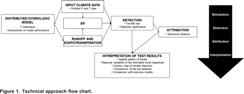
Two different meteorological input data sets were used with a distributed hydrological model to simulate hydrologic variables on a grid cell basis. A statistical test was then employed to identify trends in these variables on a grid cell basis. The major steps in this research are summarized in .
Figure 1. Technical approach flow chart.
The WATFLOOD Hydrological Model
Kouwen (Citation1996) has presented a detailed description of the model structure; a brief summary is given here. In WATFLOOD, the water balance is calculated for each grid cell using semi-empirical formulae for hydrological processes such as interception, infiltration, surface runoff, snowmelt, etc. For example, the evapotranspiration from the soil moisture storage is estimated using temperature by the procedure of Hargreaves and Samani (Citation1982) and the snowmelt is calculated using a simple degree-day method. The heat deficit of the snowpack is tracked throughout the cold season based on the air temperature. When the temperature is below freezing, the heat deficit is increased and, conversely, it is reduced when the temperature is above freezing. The heat deficit is reduced until it reaches zero; at this time any additional melt is assumed to be runoff and the volume of the snowpack is reduced by the amount of runoff until no more snow remains. The excess rainfall that exceeds the infiltration capacity becomes surface runoff whose magnitude is calculated using Manning's formula, while similar calculations are made for interflow and baseflow. The surface runoff, interflow, and baseflow in a grid cell are assumed to be the grid cell's contribution to streamflow, which is then added to the streamflow from the upstream grid cell (or grid cells) and routed through the river network to the basin outlet. This allows for the simulated streamflow to be compared to measured streamflow at any point in the watershed. Each grid cell can store water in the form of upper zone and lower zone soil moisture as well as snow.
In order to use WATFLOOD, it is necessary to properly segment or grid the watershed. For each grid cell the following characteristics are necessary: river elevation, drainage area, drainage direction, river classification, contour density, and land cover class. This information was gathered for the MRB using a combination of a digital elevation model (DEM) and a remote-sensing derived land cover model. The grid size chosen for this study was 20 km resulting in 4667 grid cells for the basin. More detail on the WATFLOOD set up on the MRB can be found in Soulis and Seglenieks (Citation2008).
The WATFLOOD model has been successfully applied in various forms for climate and hydrology studies in a number of river basins, including parts of the MRB (Cranmer et al., Citation2001; Dibike and Couibaly, Citation2004; Abdul Aziz and Burn, Citation2006; Bingeman et al., Citation2006; Sung et al., Citation2006; and Toth et al., Citation2006). This type of model was chosen rather than a full energy balance model as only temperature and precipitation were available as inputs from the observed dataset. Furthermore, the WATFLOOD model was used as a key component of the coupled hydrological modelling conducted as part of the Mackenzie GEWEX Study (MAGS) (Soulis and Seglenieks, Citation2008). There have been several recent studies examining runoff processes in cold regions (Quinton et al., Citation2004; Quinton and Carey, Citation2008; Wright et al., Citation2009; Zhang et al., Citation2010; Spence et al., Citation2010) that have led to important improvements in the understanding of cold region hydrology, particularly at the field-scale. It is hoped that some of the improvements in the understanding of these processes can soon be incorporated into hydrological models capable of modelling large watersheds, such as the MRB.
Mann-Kendall Test for Trend Detection
The Mann-Kendall (MK) non-parametric test was selected for determining the existence of a trend in hydrologic and temperature time series. Mann (Citation1945) originally used this test and Kendall (Citation1975) subsequently derived the test statistic distribution. The Mann-Kendall test checks for monotonic trends by calculating the Kendall correlation between the values of a time series and the time of occurrence of the values. Since this is a rank based approach, the test statistic depends only on the relative values of series values and subsequent values in the series. Details of the MK test are available in Cunderlik and Burn (Citation2002) and Burn et al. (Citation2004b). To account for the effect of serial correlation in the data, this study incorporated the trend free pre-whitening (TFPW) approach developed by Yue et al. (Citation2002) with a modification by Burn et al. (Citation2004b). The complete procedures are described in Burn et al. (Citation2004b). To determine if a given variable is significant at a regional scale, one has to determine the effect of cross-correlation in the data set. In this study, a bootstrap resampling approach, developed by Burn and Hag Elnur (Citation2002), was used to account for crosscorrelation. The resampling approach allows the determination of whether a significant number of significant trends has been observed (i.e., determine if the results are field significant). Field significance defines the percentage of tests that are expected to show a trend, at a given local (nominal) significance level, purely by chance.
A non-parametric robust estimate of the magnitude of the slope, , commonly referred to as the Sen slope, is given by (Burn et al., Citation2004b):
where the X i and X j are series values.
Sensitivity of Runoff to Climate
The potential impacts of climate change on the hydrologic cycle can be assessed using the non-parametric estimator proposed by Sankarasubramanian et al. (Citation2001). Climate-runoff relationships were identified by an estimate of the sensitivity (elasticity), , for each grid cell. The non-parametric estimator can be expressed as:
where R
t
is the annual runoff, C
t
can be any annual climatic variable, and and
are the long-term sample means. The sensitivity of runoff to changing climate (temperature and precipitation), as well as the sensitivity of runoff to evapotranspiration, were assessed using this approach.
Interpretation of Test Results
The analysis was conducted on a grid cell by grid cell basis and the results were then used for: 1) constructing spatial maps, 2) constructing box-plots, 3) comparing the two input data sets, 4) understanding the general changes in the hydrologic cycle in the MRB during the study period, 5) comparing the results with other detection studies done for North America, specifically in the MRB, and 6) evaluating and understanding the impacts of climate change on the hydrologic cycle in the MRB. The two meteorological data sets used as forcing data for the distributed hydrological model were also compared directly in an attempt to understand the differences in the data sets. The year 1981 was chosen to compare the two data sets for 60 randomly selected sample grid cells.
Application: The Mackenzie River Basin
The Study Site
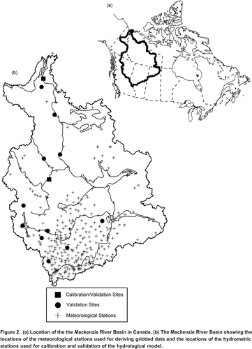
Stretching from Jasper, Alberta, in the south to the coast of the Beaufort Sea in the north, the MRB, with a drainage area of about 1.8 million km2, covers an area of approximately one-fifth of the total land area of Canada. The mainstem of the basin, the Mackenzie River, flows approximately 4,240 km from the headwaters of the Finlay River to the Arctic Ocean (Louie et al., Citation2002). As the largest source of fresh water to the Arctic Ocean from North America, the basin plays an important part in regulating the thermohaline circulation of the world's oceans (Environment Canada and the Natural Sciences and Engineering Research Council (NSERC), Citation2004). The location of the MRB is shown in ; the MRB includes three large lakes and three major deltas. Approximately 75% of the basin is underlain by permafrost.
Figure 2. (a) Location of the the Mackenzie River Basin in Canada. (b) The Mackenzie River Basin showing the locations of the meteorological stations used for deriving gridded data and the locations of the hydrometric stations used for calibration and validation of the hydrological model.
Four major physiographic regions influence the climatological and hydrological regime of the basin: the Western Cordillera, the Interior Plain, the Precambrian Shield, and the Arctic Coastal Plain (Woo and Thorne, Citation2003). The mean annual basin temperature is approximately 3.4C, and approximately 25C to 30C in winter and 15C in summer (Stewart et al., Citation2002). Annual precipitation in the basin declines from the southwest (>1000 mm) to the north (approximately 200 mm) (Woo and Thorne, Citation2003). The average annual total precipitation is approximately 421 mm (Louie et al., Citation2002) with snowfall dominating for six to eight months (Stewart et al., Citation2002). Minimum precipitation occurs during the winter months of February to April and the maximum occurs during the summer months of June to August (Stewart et al., Citation2002). For over half the year, snow stays on the ground in many parts of the basin and snowmelt usually triggers major high-flow events in the melt season (Woo and Thorne, Citation2003). Evapotranspiration occurs mainly between May to October and is approximately 260 mm yr1 (Louie et al., Citation2002).
Data Sources
Temperature and precipitation data were obtained from Environment Canada and the European Centre for Medium-range Weather Forecasting (ECMWF) reanalysis climate data (ERA-40) for the period 19612002 (ECMWF, Citation2006). Two different data sets were used because precipitation and temperature calculated using reanalysis data and gridded station data could be different (te Linde et al., Citation2008). The Environment Canada data were obtained from the National Climate Data and Information Archive (National Climate Data and Information Archive, Citation2005), operated and maintained by the Meteorological Service of Canada. Although the data provided by Environment Canada have gone through a quality control procedure, there is still the possibility that some data may be unreliable. However, it was beyond the scope of this study to perform a rigorous quality assurance procedure. The climate data used from this data set are gridded using all available stations. There were approximately 350 stations used in the analysis, although the number of stations varied over time as all the stations that were available were used at each time period. The locations of the meteorological stations are shown on . The hydrological model divided the basin into 4667 grid cells for this study. Consequently, the station data were used to derive climatic information for each of the grid cells using an inverse distance weighting technique, while the temperature data were also adjusted using a lapse rate based on elevation. This method was chosen as it has proven to give adequate results in other studies (Soulis and Seglenieks, Citation2008).
ECMWF produced reanalysis data sets for the period 1957 to 2002 using the ERA-40 data assimilation system (ECMWF, Citation2006). The reanalysis climate data cover the globe on an 125 km grid spacing at a six-hour time interval (Kllberg et al., Citation2005). The data were interpolated onto the 20 km grid used in the hydrological model also using an inverse distance weighting technique.
Variable Selection
The major components of the water cycle include precipitation (rainfall and snow combined) (P), evapotranspiration (ET), runoff (R), and storage (S). The annual value and monthly mean of these four variables and air temperature (T) were selected for this study. The annual values for P, ET, and R are the total mm of water for the particular year, whereas the annual values for T are the monthly averaged values in C over the particular year.
The precipitation and temperature of the interpolated Environment Canada data and ECMWF data were used directly for the analysis. To calculate the other components of the water cycle, the daily precipitation and temperature time series were used as inputs into the WATFLOOD distributed hydrological model. The change in storage was calculated using the WATFLOOD hydrological model based on the water-balance equation:
Results
This section presents the results of the hydrological model, the MK test and the sensitivity (elasticity) analysis for the 1961 to 2002 study period.
Hydrological Model
The 4667 grid cells were used for estimating meteorological inputs from the two data sources and for the modelling analysis with the distributed hydrological model. The WATFLOOD model was calibrated based on five years of data using an objective function based on the monthly Nash-Sutcliffe value of the simulated streamflow for the station located at Fort Liard on the Liard River near the center of the basin. This station was used as it is the largest unregulated watershed within the MRB. The Nash-Sutcliffe values for two calibration/validation stations (the Liard River at Fort Liard and the Mackenzie River at Arctic Red) for each data set are listed in . These two stations formed the basis for the calibration of the model; the Nash-Sutcliffe values for the Liard station represent a combination of calibration and validation results, while the values for the Mackenzie station represent validation results. also includes validation results for a collection of smaller and medium sized sub-watersheds of the MRB. These are presented to show the capability of the model for reproducing monthly runoff at a smaller spatial scale. A Nash-Sutcliffe value of one indicates perfect agreement while a value of less than zero indicates that the model performs worse than using the observed mean as a predictor. The results using the Environment Canada data set are generally better than the results from using the ECMWF data set. This outcome is consistent with the results from te Linde et al. (Citation2008) who found that reanalysis data provided poorer model results than results obtained with gridded data obtained from the Climatic Research Unit (Mitchell and Jones, Citation2005). The Nash-Sutcliffe values indicate that the model is capable of reasonably estimating the streamflow from both data sets for a monthly time step, which is the focus of the analysis conducted in this research.
Table 1. Nash-Sutcliffe values for both data sets for a monthly time step for calibration and validation results.
Performance of the distributed hydrologic model may vary according to season, land-cover type and model resolution. The model performance is also affected by errors in the meteorological data, precipitation and temperature. Both the gridded station data (Environment Canada) and the reanalysis data (ECMWF) are subject to errors that can result in errors in the modelled hydrological variables. The Environment Canada data are derived from station data; however, the station density in the remote Canadian north is low (see and Louie et al., Citation2002), which can result in errors in the gridded estimates especially for grid cells that are lengthy distances from the nearest gauging station. The ECMWF reanalysis data are derived from the integration of results from an atmospheric model with observations from data sources. This data product is thus subject to errors from both the model and from the observed data. Past research has found that forcing the same hydrological model with gridded observed data and with reanalysis data can lead to different model performance (te Linde et al., Citation2008).
As streamflow is measured at various locations throughout the watershed, the modelled runoff can be evaluated more readily than other components of the water balance. Thus, among the two modelled water balance components used in this study, evapotranspiration, which is rarely measured, is not as reliable. However, as all the components of the water balance are inter-related, large errors in the simulated evapotranspiration would cause noticeable errors in the simulated runoff. As the runoff and precipitation values are reasonable when compared to station data, it gives more confidence that the other components of the water balance, such as evapotranspiration, are also reasonable.
It is important to note that there can be many uncertainties feeding into the hydrological model other than the uncertainties within the model itself. For example, uncertainties in the non-climate inputs such as changes in land use or vegetation (Merritt et al., Citation2006) and uncertainties in the climate inputs (Jones et al., Citation2006) can have a larger effect on the simulation outputs than the inaccuracy of the models themselves.
For both input datasets, WATFLOOD was started in 1960 using average initial conditions for the state variables of the basin, such as soil moisture, snow water equivalent, and baseflow. The model was then spun up for a year and the data analysis started in 1961.
Trends
The results of the MK test are presented based on the 10% local and global (field) significance levels.
Temperature
summarizes the percentage of grid cells that exhibit a significant trend (10% significance level) for each month and on an annual basis. Results that are field significant are indicated in bold. Mean monthly temperature records show a strongly significant, positive trend in the winter and early-spring months of December to March, particularly for the Environment Canada data set. Increasing temperature trends have been more modest in the summer months. One contrary pattern was observed in October temperature. There was a relatively large number of grid cells (over 25%) with cooling trends in October. In both data sets, the regional annual mean temperature exhibited a significant increasing trend. The annual mean temperature increased regionally by 2.28C for the 42-year period for the Environment Canada data set and by 1.22C for the ECMWF data set. In both data sets, over 80% of the grid cells show increasing annual mean temperature during the study period.
Table 2. Percentage of grid cells with a significant trend (10% significance level).
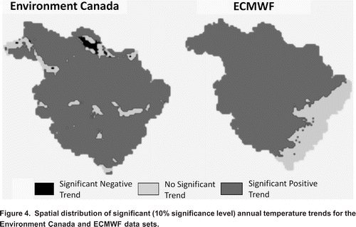
shows the average trend slope for each month and on an annual basis for both data sets. This figure reveals that the Environment Canada dataset generally exhibited larger average trend magnitudes than was the case for the ECMWF. The temporal patterns of the trends for the two data sets were quite similar with larger slopes in the winter and early spring and smaller slopes in the summer and early autumn. The Environment Canada date set generally exhibited more significant trends and also a larger average trend slope magnitude. shows the spatial distribution of trends for annual temperature for both data sets.
Figure 3. Average temperature trend slopes on a monthly (left y-axis) and annual (right y-axis) basis for the Environment Canada and ECMWF data sets based on the 4667 grid cells.
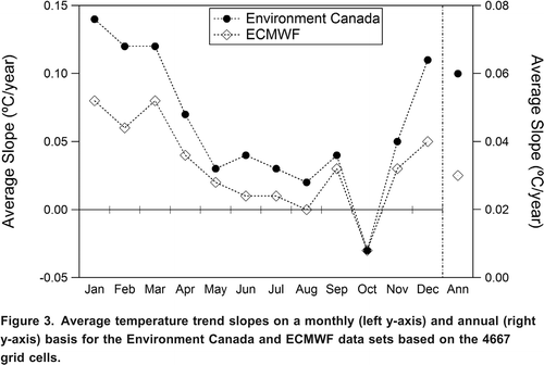
Figure 4. Spatial distribution of significant (10% significance level) annual temperature trends for the Environment Canada and ECMWF data sets.
Precipitation
presents the trend summary for precipitation. In general, the ECMWF data set showed more positive trends and the Environment Canada data set showed more negative trends. The summer months of May to August and early autumn (September) showed the largest number of positive regional trends in both data sets (most results are field significant for both data sets); winter months generally showed regional decreasing trends (Environment Canada data set) or no trends (ECMWF data set) in the precipitation amount. On an annual basis, there was an overall increase in precipitation, although for the Environment Canada data set, there are also grid cells with significant decreasing trends on an annual basis.
shows the average trend slope for precipitation on a monthly and annual basis. Although the seasonal pattern of both data sets is quite similar, the average slope for the Environment Canada data set is always lower than for the ECMWF data set. In addition, some of the average slopes are opposite in direction, indicating that the Environment Canada data have weaker positive trends (particularly in the summer months) or stronger negative trends (particularly in the winter months).
Figure 5. Average precipitation trend slopes on a monthly (left y-axis) and annual (right y-axis) basis for the Environment Canada and ECMWF data sets based on the 4667 grid cells.
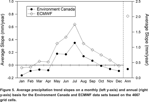
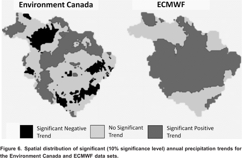
The spatial distribution of trends in annual precipitation is plotted in . On an annual basis, increasing trends were dominant in the central basin for both data sets, but the spatial extent of increasing trends for the Environment Canada data set was much smaller. It is also apparent that annual precipitation for the Environment Canada data set contains both significant increasing and decreasing trends; only significant increasing trends were observed for the ECMWF data set.
Figure 6. Spatial distribution of significant (10% significance level) annual precipitation trends for the Environment Canada and ECMWF data sets.
Runoff
On an annual basis, an overall decrease in runoff was detected from the modelled runoff using the Environment Canada data set, while an overall increase in runoff was detected from the modelled runoff using the ECMWF data set (). The runoff for both data sets demonstrates predominately increasing trends in the winter months and either a decreasing trend (modelled runoff using the Environment Canada data set) or less increasing trends (modelled runoff using the ECMWF data set) for the month of May. This result is consistent with a shift in the timing of the spring freshet to earlier in the year. shows the average trend slope for runoff on a monthly and annual basis. Noteworthy is that the average trend magnitudes from the modelled runoff using the Environment Canada data set were always the same as or lower than results from the modelled runoff using the ECMWF data set. However, the spatial pattern of annual runoff changes () follows closely with the pattern of change in precipitation for both data sets (). Note from that there were significant positive and negative trends for the modelled runoff using the Environment Canada data set, but only significant positive trends were detected for the modelled runoff using the ECMWF data set. shows the percentage of grid cells with significant trends (both increasing and decreasing) and the percentage of grid cells with no significant trend. The modelled runoff using the ECMWF data set has 64.1% of the grid cells with a significant increasing trend, while the modelled runoff using the Environment Canada data set has 24.4%, with a significant increasing trend and 26.3% with a significant decreasing trend. Of the grid cells that exhibit an increasing trend for the modelled runoff using the ECMWF data set but not for the modelled runoff using the Environment Canada data set, roughly 24% have a decreasing trend for the modelled runoff using the Environment Canada data set. The other combinations of outcomes demonstrate a stronger agreement between the two data sets. As also indicated in , the runoff derived using the ECMWF data results in more increasing trends than occur in the results derived using the Environment Canada data.
Figure 7. Average trend slopes on a monthly (left y-axis) and annual (right y-axis) basis for runoff derived using the Environment Canada and ECMWF data sets based on the 4667 grid cells.
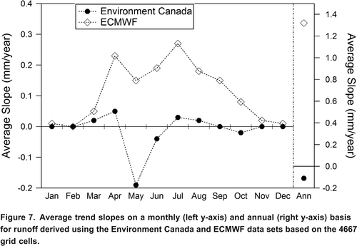
Figure 8. Spatial distribution of significant (10% significance level) annual runoff trends for the Environment Canada and ECMWF data sets.
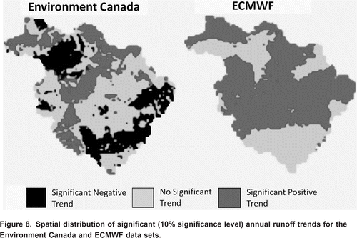
Table 3. Comparison of the percentage of grid cells in each of three trend categories (at the 10% significance level) for runoff derived using the Environment Canada and ECMWF data sets.
Evapotranspiration
The MRB has generally experienced increasing evapotranspiration, which has been most significant in the summer months based on the modelled evapotranspiration from both data sets (). The summer months all exhibit a number of trends that are field significant (10% significance level) with very few significant decreasing trends.
shows the average trend slope for evapotranspiration on a monthly and annual basis. The figure indicates that the average trend slopes from the modelled evapotranspiration for the ECMWF data set are generally larger in magnitude (and also more positive) than the modelled evapotranspiration for the Environment Canada data set.
Figure 9. Average trend slopes on a monthly (left y-axis) and annual (right y-axis) basis for evapotranspiration derived using the Environment Canada and ECMWF data sets based on the 4667 grid cells.
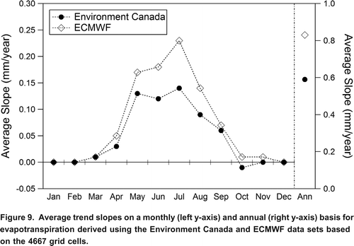
One interesting feature is that the seasonal pattern of the average trends in evapotranspiration was visually similar in terms of trend direction to the seasonal pattern for precipitation for both data sets. This result is physically reasonable because evapotranspiration depends on the availability of both energy and water (Brutsaert, Citation2005). Walsh et al. (Citation1994) also found that the temporal pattern of estimated evaporation had the same phase as that of precipitation.
shows maps with the trends in annual evapotranspiration from 1961 to 2002. Some clusters of decreasing trends were observed for the modelled evapotranspiration from the Environment Canada data set, but none for the modelled evapotranspiration from the ECMWF data set. There is evidence of some spatial coherence observed between the precipitation and evapotranspiration from the plots in and . shows the percentage of grid cells with significant trends (both increasing and decreasing) and the percentage of grid cells with no significant trend. The modelled evapotranspiration for the ECMWF data set has 83% of the grid cells with a significant increasing trend while the modelled evapotranspiration for the Environment Canada data set has 56% with a significant increasing trend and only 3% with a significant decreasing trend. The agreement between the two driving data sets is thus stronger for evaporation than was observed for runoff. The evapotranspiration derived using the ECMWF data again results in more increasing trends than was the case when using Environment Canada data, as can also be inferred from .
Figure 10. Spatial distribution of significant (10% significance level) annual evapotranspiration trends for the Environment Canada and ECMWF data sets.
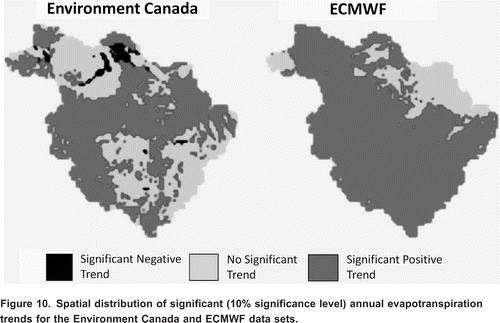
Table 4. Comparison of the percentage of grid cells in each of three trend categories (at the 10% significance level) for evapotranspiration derived using the Environment Canada and ECMWF data sets.
Storage
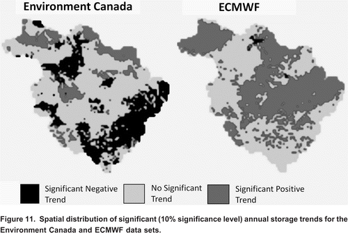
presents maps of the trends in annual storage. The annual storage and annual runoff are visually similar in terms of the spatial distribution and direction of trends. This may suggest the two variables are related to each other or that both of these variables are affected by the change in precipitation. The annual storage derived from the Environment Canada data set exhibits 14.1% of the grid cells with a significant (10% significance level) increasing trend and 28.8% with a significant decreasing trend. The corresponding values for the annual storage derived using the ECMWF data set are 49.6% significant increasing trend and 0.7% significant decreasing trend. The results for both data sets are field significant. There are clearly substantive differences in the annual storage values between the two data sets, as can also be inferred from .
Figure 11. Spatial distribution of significant (10% significance level) annual storage trends for the Environment Canada and ECMWF data sets.
presents box plots that compare the trend slopes for the annual storage derived using the Environment Canada data set and the ECMWF data set for all the grid cells. For the storage derived using the ECMWF data set, the majority of the grid cells exhibit positive trend slopes for annual storage. The average trend slope for the storage derived using the Environment Canada data set is 0.14 mm yr1 while for the storage derived using the ECMWF data set the average trend slope is 0.47 mm yr1. For the storage derived using the Environment Canada data set, over 60% of grid cells exhibit a negative slope indicating a preponderance of decreasing trends. shows the percentage of grid cells with significant trends (both increasing and decreasing) and the percentage of grid cells with no significant trend. The ECMWF data set has 50% of the grid cells with a significant increasing trend, while the Environment Canada data set has 14% with a significant increasing trend and 29% with a significant decreasing trend. The agreement between the annual storage values obtained using the two driving data sets is thus quite weak.
Figure 12. Box plots of annual storage trends derived using the Environment Canada and ECMWF data sets based on the 4667 grid cells. The boxes show the first quartile, median, and the third quartile. The whiskers extend from the box to the 5 and 95 percentiles.
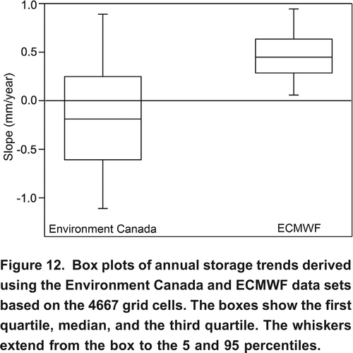
Table 5. Comparison of the percentage of grid cells in each of three trend categories (at the 10% significance level) for storage derived using the Environment Canada and ECMWF data sets.
Regional Climate Sensitivity
The precipitation elasticity of runoff (P), the evapotranspiration elasticity of runoff (PET), and the temperature elasticity of runoff (T) are determined by EquationEquation 2. The regional median climate elasticity (sensitivity) of runoff values for P, PET, T were, respectively, 1.28, 0.87 and 0.04 for the analysis based on the Environment Canada data set and 1.42, 1.89 and 0.17 for the ECMWF data set. A value >1.0 indicates that a 1% change in the climate variable can cause a >1% change in runoff. From the results, some general conclusions are: 1) runoff was more sensitive to precipitation and evapotranspiration, and less sensitive to temperature; 2) runoff was positively correlated with precipitation and evapotranspiration, whereas runoff was negatively correlated with temperature; and 3) the regional P, PET, and T values from the ECMWF data set were stronger.
The results for runoff sensitivity to temperature indicate that the dominant impact of increased temperature is increased losses due to evapotranspiration and hence reduced runoff in the basin. Moreover, one interesting finding from the climate elasticity results is that the regional runoff increases with the regional evapotranspiration for both data sets. This unexpected relationship may imply another variable, such as storage, as having an impact. Increases in soil moisture can cause more runoff generation in a grid cell due to less storage capacity to withhold meltwater and/or rainfall (Woo and Marsh, Citation2005) and can also provide more soil moisture storage available for evapotranspiration (Douglas et al., Citation2000).
Comparisons of the Two Data Sets
The average annual precipitation from the 60 sample grid cells for 1981 was similar for the two data sets although there were differences in the monthly precipitation values, with Environment Canada data generally exhibiting more precipitation than ECMWF in summer and less in the winter. On an annual basis, the average temperature values were also similar with differences again occurring in the monthly values. The average annual runoff and evapotranspiration were less for the results from the hydrological model driven by the Environment Canada data set.
Correlation analysis applied to annual values for each variable from the two data sets at the 60 sample grid cells reveals a range of values. The correlation coefficients for temperature, precipitation, runoff, evapotranspiration and storage are 0.86, 0.32, 0.45, 0.89 and 0.60, respectively. Thus there is a very strong relationship for temperature and evapotranspiration and a much weaker relationship for precipitation. The latter likely reflects differences in the nature of the two driving data sets. However, there is a good correspondence in the seasonal and spatial patterns of trends, the magnitude of the climate sensitivity, and the magnitude of the original data between the two data sets.
Discussion
Comparisons with Other Studies
Temperature
Similar to other trend detection studies for North America (Kwong and Gan, Citation1994; Lettenmaier et al., Citation1994; Zhang et al., Citation2000) regional warming temperature and increasing precipitation have been detected in the MRB. Most of these studies indicated that the greatest warming in higher latitude occurs during the winter months. Zhang et al. (Citation2000) observed that the warming trend for 1950 to 1998 is strongest during winter and early spring in the north-west of Canada. Gan (Citation1995) also reported significant warming trends for the 1949 to 1989 period in January to June, and a cooling trend in October over western Canada. Specifically in the MRB, Abdul Aziz and Burn (Citation2006) have investigated climate trends for the 1960 to 2000 period and observed a very strong increase in temperature in winter months of December to April and some cooling trends in October. These observed temperature trends are in agreement with the findings in this study.
Precipitation
This study indicates a weak decrease in winter precipitation (more noticeable in the Environment Canada data set) and a strong increase in summer precipitation, with an overall increase in annual precipitation. The distribution of trends in monthly precipitation in this study is roughly the same as the trends in precipitation found by Abdul Aziz and Burn (Citation2006). These results are closer to the pattern of the trend results obtained from the ECMWF data set in this study.
Zhang et al. (Citation2000) observed increasing precipitation for the 1950 to 1998 period in winter and spring, and on an annual basis, although they found some decreasing trends in winter for the southern portion of the MRB. Many of the increasing trends are statistically significant, at the 5% significance level. The summer season exhibits a mix of increasing and decreasing (but insignificant) trends, while the fall showed weak (and mainly insignificant) increasing trends. These results are in general agreement with the precipitation trend results for this work. The discrepancies that do arise may result from the length of the observation period (1950 to 1998 for Zhang et al. (Citation2000) versus 1961 to 2002 in this study). The findings from this study and that of Zhang et al. (Citation2000) study may suggest that summer precipitation exhibited a strong increase after 1960. The observed change in the annual precipitation is in general agreement in both studies.
Runoff
Previous studies indicate a general increase in runoff in North America (Lettenmaier et al., Citation1994; Douglas et al., Citation2000; Gedney et al., Citation2006). Zhang et al. (Citation2001) for the 1967 to 1996 period and Burn and Hag Elnur (2002) for the 1960 to 1997 period detected a general upward trend in the MRB region. Dry and Wood (Citation2005) detected a 2% increase of river discharge to the Arctic Ocean from northern Canada for the period 1964 to 2003, although the trend is statistically insignificant at the 5% significance level.
Specifically in the MRB region, Burn et al. (Citation2004a) and Abdul Aziz and Burn (Citation2006) found increasing runoff in winter and spring, but reduced runoff in summer and fall and reduced annual runoff based on observational data for the period of 1960 to 2000. These results are consistent with the trends detected from the Environment Canada data set in this study. The conditions in the MRB, with slightly increasing runoff from the ECMWF data set, are consistent with results reported from Louie et al. (Citation2002) for the 1972 to 1995 period.
Evapotranspiration
Previous studies predicted an overall increase in evapotranspiration in response to warmer temperatures (Loaiciga et al., Citation1996; Trenberth, Citation1998; Douville et al., Citation2002; Labat et al., Citation2004; Huntington, Citation2006). This study indicates that evapotranspiration has also increased in the MRB. Nijssen et al. (Citation2001) and Louie et al. (Citation2002) obtained a similar result for the MRB from their models. Nijssen et al. (Citation2001) predicted most of the increase in evapotranspiration to take place during the summer months, similar to the findings in this study (see ).
Storage
The increase in storage for the results obtained using the ECMWF data set is in general agreement with the WATFLOOD modelled storage from previous work. Soulis and Seglenieks (Citation2008) found an increase in storage for the MRB from modelling using WATFLOOD for the period 1994 to 2004. The modelling driven by the Environment Canada data set, with a decrease in storage, is consistent with the findings from Louie et al. (Citation2002) for the 1972 to 1995 period. Since the time period for neither of these studies corresponds to the time period for this study, it is not easy to establish which of the conflicting storage trend outcomes is most credible. However, te Linde et al. (Citation2008) found that reanalysis data provided poorer model results than results obtained with gridded data, implying that perhaps greater confidence should be placed on the storage results obtained using the Environment Canada data.
Sensitivity
Similar to the results of Karl and Riebsame (Citation1989) and Nijssen et al. (Citation2001), modelled runoff was more sensitive to changes in precipitation than to changes in temperature. The sensitivity of runoff to precipitation was an order of magnitude higher than the sensitivity to temperature. The sensitivity of runoff to precipitation is 1.2 to 1.5, which is in good agreement with the estimates of 1.0 by Gedney et al. (Citation2006). The sensitivity of runoff to temperature, however, was opposite in direction. Nijssen et al. (Citation2001) projected a similar response with increasing temperature, with the exception of spring runoff.
The results of the analysis obtained using the Environment Canada dataset support the findings of Wigley and Jones (Citation1985) that changes in runoff are more sensitive to changes in precipitation than to changes in evapotranspiration. For the ECMWF data set, however, the sensitivity of runoff to evapotranspiration is stronger than that to precipitation.
The sensitivity analysis indicated that the P and PET values are quite similar, in terms of magnitude and direction; Liu et al. (Citation2002) observed a pattern for moisture flux convergence such that the high value of elasticity is associated with a low value of moisture flux convergence, and vice-versa. They have also shown the linkage of moisture flux convergence with precipitation, evaporation, and discharge. This implies that P and PET in the MRB are likely to be affected by the moisture flux convergence.
Water Balance Changes
The largest number of significant trends generally occurred in the summer months, but hydrological change in winter is a very important process in a snow-dominated basin, such as the MRB. Since runoff and evapotranspiration are limited during winter, any change in the precipitation amount affects the water storage in the snow pack. The snow pack thus integrates the effects of hydrological change during the winter months. This water storage becomes available for runoff or evapotranspiration the following spring and summer.
For the Environment Canada data set, the decrease in regional winter precipitation, as well as any increase in snowpack sublimation, would decrease the moisture storage during winter. Consequently, the total amount of snowmelt runoff is decreased. However, there is an increase in the December to April period runoff derived using the Environment Canada data set (see ). This result suggests that warmer spring temperature has increased snowmelt that used to occur in later months (i.e., a change in timing of runoff). Reduced snowmelt in the months of May and June has led to decreased runoff in these months.
For the results derived from the ECMWF data set, there is a weak decrease in regional winter precipitation. For most of the remaining months, the spatial pattern of changes in runoff follows more closely with the pattern of changes in precipitation, as compared to the results derived from the Environment Canada data set (see and ). Changes in the amount of runoff for most of the months are also larger in spatial extent and more sensitive to changes in precipitation as compared to the results derived from the Environment Canada data set. Overall, increasing regional winter runoff but decreasing regional winter precipitation was detected from both data sets.
An increase in precipitation and evapotranspiration, leading to an intensification (or acceleration) of the hydrologic cycle (Huntington, Citation2006) is evident in the Mackenzie River Basin, especially for the results derived from the ECMWF data set. These results have important implications for future scenarios, as a continued warming will undoubtedly result in dramatic changes in the hydrologic cycle in the MRB. Climatic warming is likely to further increase the precipitation amount (Intergovernmental Panel on Climate Change (IPCC), Citation2007), thereby increasing the evapotranspiration and affecting the timing and amount of runoff and storage in the MRB, particularly as the rate of warming in the 21st century is expected to be several times greater than in the 20th century (Nijssen et al., Citation2001). Moreover, climate change itself could trigger additional increases in greenhouse gases and reduction in surface albedo, which further amplify the effects of a change in climate forcing (IPCC, Citation2007).
Conclusions and Recommendations
The trend analysis results reported herein reveal substantive changes in the hydrological regime within the MRB, both on an annual and a seasonal basis. There are agreements in the results from the two driving data sets as well as disagreements, with many hydrological variables demonstrating similarity in the seasonal pattern of the average trend slope of the variables. For both data sets, there is a warming trend on an annual and monthly basis, except for the month of October. There are generally decreases in winter precipitation and increases in summer precipitation as well as summer evapotranspiration. There are differences in the results obtained from the two data sets for runoff and annual storage, with the results obtained using the Environment Canada data set demonstrating more decreasing trends than the results obtained using the ECMWF data set. However, the results obtained from both data sets reveal changes in both the timing and magnitude of runoff for the Mackenzie River Basin, which could have substantial impacts on water availability as well as the water resource infrastructure in the watershed. There is evidence to support an intensification of the hydrologic cycle within the watershed in recent years, especially for the results obtained using the ECMWF data.
Given the magnitude of the changes noted herein, detection and attribution studies should be an ongoing exercise particularly for high latitude watersheds, such as the MRB. It is also important to be aware of the consequences of climatic change and its impacts on the planning and management strategies for future water resource systems. Future work should be directed toward developing a method for distinguishing the natural climate variability and the human-induced climate change impacts on the hydrologic cycle.
Acknowledgements
This research was funded by the Mackenzie GEWEX Study (MAGS), Environment Canada, and the Natural Sciences and Engineering Research Council of Canada (NSERC). The authors acknowledge the many useful comments from two anonymous reviewers and the Associate Editor.
References
- Abdul Aziz , O. I. and Burn , D. H. 2006 . Trends and variability in the hydrological regime of the Mackenzie River Basin . Journal of Hydrology , 319 : 282 – 294 .
- Bingeman , A. K. , Kouwen , N. and Soulis , E. D. 2006 . Validation of the hydrological processes in a hydrological model . Journal of Hydrologic Engineering , 11 ( 5 ) : 451 – 463 .
- Brutsaert, W. 2005. Hydrology: An introduction. Cambridge, UK: Cambridge University Press, 605 pp.
- Burn , D. H. 1994 . Hydrologic effects of climatic change in west-central Canada . Journal of Hydrology , 160 : 53 – 70 .
- Burn , D. H. 2008 . Climatic influences on streamflow timing in the headwaters of the Mackenzie River Basin . Journal of Hydrology , 352 : 225 – 238 .
- Burn , D. H. and Hag Elnur , M. A. 2002 . Detection of hydrologic trends and variability . Journal of Hydrology , 255 : 107 – 122 .
- Burn , D. H. , Abdul Aziz , O. I. and Pietroniro , A. 2004a . A comparison of trends in hydrological variables for two watersheds in the Mackenzie River Basin . Canadian Water Resources Journal , 29 ( 4 ) : 283 – 298 .
- Burn , D. H. , Cunderlik , J. M. and Pietroniro , A. 2004b . Hydrological trends and variability in the Liard River Basin . Hydrological Sciences Journal , 49 ( 1 ) : 53 – 67 .
- Cao , Z. , Wang , M. , Proctor , B. A. , Strong , G. S. , Stewart , R. E. , Ritchie , H. and Burford , J. E. 2002 . On the physical process associated with the water budget and discharge of the Mackenzie Basin during the 1994/95 water year . Atmosphere-Ocean , 40 ( 2 ) : 125 – 143 .
- Chahine , M. T. 1992 . The hydrological cycle and its influence on climate . Nature , 359 : 373 – 380 .
- Cranmer , A. J. , Kouwen , N. and Mousavi , S. F. 2001 . Proving WATFLOOD: Modelling the nonlinearities of hydrologic response to storm intensities . Canadian Journal of Civil Engineering , 28 : 837 – 855 .
- Cunderlik , J. M. and Burn , D. H. 2002 . Local and regional trends in monthly maximum flows in southern British Columbia . Canadian Water Resources Journal , 27 ( 2 ) : 191 – 212 .
- Dry, S. J., and E. F. Wood. 2005. Decreasing river discharge in northern Canada. Geophysical Research Letters 32: L10401, doi: 10.1029/2005GL022845.
- Dibike, Y. B., and P. Coulibaly. 2004. Hydrologic impact of climate change in the Saguenay watershed. In Proceedings of the 57th Canadian Water Resources Association Annual Congress. Montreal, Quebec, June 1618, 2004, 8 pp.
- Douglas , E. M. , Vogel , R. M. and Kroll , C. N. 2000 . Trends in floods and low flows in the United States: Impact of spatial correlation . Journal of Hydrology , 240 : 90 – 105 .
- Douville , H. , Chauvin , F. , Planton , S. , Royer , J.-F. , Salas-Melia , D. and Tyteca , S. 2002 . Sensitivity of the hydrological cycle to increasing amounts of greenhouse gases and aerosols . Climate Dynamics , 20 : 45 – 68 .
- European Centre for Medium-range Weather Forecasting (ECMWF). 2006. ECMWF re-analysis ERA-40. European Centre for Medium-Range Weather Forecasts. http://www.ecmwf.int/products/data/archive/descriptions/e4/index.html (accessed October 2005).http://www.ecmwf.int/products/data/archive/descriptions/e4/index.html
- Environment Canada. 2001. Climate change and Canada's water resources: Predicting the future. http://www.ec.gc.ca/science/sandenov01/article3_e.html (accessed February 2007).http://www.ec.gc.ca/science/sandenov01/article3_e.html
- Environment Canada and the Natural Sciences and Engineering Research Council (NSERC). 2004. The Mackenzie GEWEX study. http://www.usask.ca/geography/MAGS/index_e.htm (accessed September 2005).http://www.usask.ca/geography/MAGS/index_e.htm
- Gan , T. Y. 1995 . Trends in air-temperature and precipitation for Canada and north-eastern USA . International Journal of Climatology , 15 ( 10 ) : 1115 – 1134 .
- Gedney , N. , Cox , P. M. , Betts , R. A. , Boucher , O. , Huntingford , C. and Stott , P. A. 2006 . Detection of a direct carbon dioxide effect in continental river runoff records . Nature , 439 ( 16 ) : 835 – 838 .
- Hargreaves , G. H. and Samani , Z. A. 1982 . Estimating potential evapotranspiration . Journal of the Irrigation and Drainage Division , 108 ( 3 ) : 225 – 230 .
- Huntington , T. G. 2006 . Evidence for intensification of the global water cycle: Review and synthesis . Journal of Hydrology , 319 : 83 – 95 .
- Intergovernmental Panel on Climate Change (IPCC). 2007. Summary for policymakers. Contribution of Working Group I to the Fourth Assessment Report of the Intergovernmental Panel on Climate Change. Geneva: IPCC, 18 pp.
- Jones , R. N. , Chiew , F. H. S. , Boughton , W. C. and Zhang , L. 2006 . Estimating the sensitivity of mean annual runoff to climate change using selected hydrological models . Advances in Water Resources , 29 : 1419 – 1429 .
- Kllberg, P., P. Berrisford, B. Hoskins, A. Simmons, S. Uppala, S. Lamy-Thpaut, and R. Hine. 2005. ERA-40 Project Report Series No. 19. http://www.ecmwf.int/publications/library/do/references/list/192 (accessed July 2007).http://www.ecmwf.int/publications/library/do/references/list/192
- Karl , T. R. and Riebsame , W. E. 1989 . The impact of decadal fluctuations in mean precipitation and temperature on runoff: A sensitivity study over the United States . Climatic Change , 15 : 423 – 447 .
- Kendall, M. G. 1975. Rank correlation measures. London, UK: Charles Griffin, 202 pp.
- Kouwen, N. 1996. WATFLOOD/ WATROUTE: Hydrological model routing & flow forecasting system. Surveys and Information Branch, Ecosystem Science and Evaluation Directorate, Environment Canada. Ottawa: Environment Canada, 217 pp.
- Kwong , Y. T. J. and Gan , T. Y. 1994 . Northward migration of permafrost along the Mackenzie highway and climatic warming . Climatic Change , 26 ( 4 ) : 399 – 419 .
- Labat , D. , Goddris , Y. , Probst , J. L. and Guyot , J. L. 2004 . Evidence for global runoff increase related to climate warming . Advances in Water Resources , 27 : 631 – 642 .
- Lettenmaier , D. P. , Wood , E. F. and Wallis , J. R. 1994 . Hydro-climatological trends in the continental United States, 1948-88 . Journal of Climate , 7 : 586 – 607 .
- Liu , J. , Cho , H. R. and Stewart , R. E. 2002 . Characteristics of the water vapour transport over the Mackenzie River Basin during the 1994/95 water year . Atmosphere-Ocean , 40 ( 2 ) : 101 – 111 .
- Loaiciga , H. A. , Valdes , J. B. , Vogel , R. , Garvey , J. and Schwartz , H. 1996 . Global warming and the hydrologic cycle . Journal of Hydrology , 174 : 83 – 127 .
- Louie , P. Y. T. , Hogg , W. D. , MacKay , M. D. , Zhang , X. and Hopkinson , R. F. 2002 . The water balance climatology of the Mackenzie Basin with reference to the 1994/95 water year . Atmosphere-Ocean , 40 ( 2 ) : 159 – 180 .
- Mann , H. B. 1945 . Non-parametric tests against trend . Econometrica , 13 : 245 – 259 .
- Merritt , W. S. , Alila , Y. , Barton , M. , Taylor , B. , Cohen , S. and Neilsen , D. 2006 . Hydrologic response to scenarios of climate change in subwatersheds of the Okanagan basin, British Columbia . Journal of Hydrology , 326 : 79 – 108 .
- Mitchell , T. D. and Jones , P. D. 2005 . An improved method of constructing a database of monthly climate observations and associated high-resolution grids . International Journal of Climatology , 25 : 693 – 712 .
- National Climate Data and Information Archive. (2005). 2002 CDCD West CD. Meteorological Service of Canada [MSC], Environment Canada. http://www.climate.weatheroffice.ec.gc.ca/prods_servs/cdcd_iso_e.html (accessed October 2005).http://www.climate.weatheroffice.ec.gc.ca/prods_servs/cdcd_iso_e.html
- Nicholls, N., G. V. Gruza, J. Jouzel, T. R. Karl, L. A. Ogallo, and D. E. Parker. 1996. Observed climate variability and change. In Climate change 1995: The science of climate change, ed. J. T. Houghton, 132192. New York: Cambridge University Press.
- Nijssen , B. , O'Donnell , G. M. , Hamlet , A. F. and Lettenmaier , D. P. 2001 . Hydrologic sensitivity of global rivers to climate change . Climatic Change , 50 : 143 – 175 .
- Quinton , W. L. and Carey , S. K. 2008 . Towards an energy-based runoff generation theory for tundra landscapes . Hydrological Processes , 22 : 4649 – 4653 .
- Quinton , W. L. , Carey , S. K. and Goeller , N. T. 2004 . Snowmelt runoff from northern alpine tundra hillslopes: Major processes and methods of simulation . Hydrology and Earth System Sciences , 8 ( 5 ) : 877 – 890 .
- Sankarasubramanian , A. , Vogel , R. M. and Limbrunner , J. F. 2001 . Climate elasticity of streamflow in the United States . Water Resources Research , 37 ( 6 ) : 1771 – 1781 .
- Soulis, E. D., and F. R. Seglenieks. 2008. The MAGS integrated modelling system. Chap. 24 in Cold region atmospheric and hydrologic studies: The Mackenzie GEWEX experience, ed. M.-K. Woo, vol. 2: 445473. New York: Springer.
- Soulis, E. D., S. I. Solomon, M. Lee, and N. Kouwen. 1994. Changes to the distribution of monthly and annual runoff in the Mackenzie Basin under climate change using a modified square grid approach. In MBIS Interim Report #2, 197-209. Northern Climate Meeting/MBIS Mid-Study Workshop, Yellowknife, NWT, April 10-14, 1994. Ottawa: Environment Canada.
- Spence , C. 2002 . Streamflow variability (19651998) in five Northwest Territories and Nunavut Rivers . Canadian Water Resources Journal , 27 ( 2 ) : 135 – 154 .
- Spence , C. , Guan , X. J. , Phillips , R. , Hedstrom , N. , Granger , R. and Reid , B. 2010 . Storage dynamics and streamflow in a catchment with a variable contributing area . Hydrological Processes , 24 : 2209 – 2221 .
- Stewart , R. E. , Leighton , H. G. , Marsh , P. , Moore , G. W. K. , Ritchie , H. , Rouse , W. R. , Soulis , E. D. , Strong , G. S. , Crawford , R. W. and Kochtubajda , B. 1998 . The Mackenzie GEWEX study: The water and energy cycles of a major North American river basin . Bulletin of the American Meteorological Society , 79 : 2665 – 2693 .
- Stewart , R. E. , Bussires , N. , Cao , Z. , Cho , H. R. , Hudak , D. R. , Kochtubajda , B. , Leighton , H. G. , Louie , P. Y. T. , MacKay , M. D. , Marsh , P. , Strong , G. S. , Szeto , K. K. and Burford , J. E. 2002 . Hydrometeorological features of the Mackenzie Basin climate system during the 1994/95 water year: A period of record low discharge . Atmosphere-Ocean , 40 ( 2 ) : 257 – 278 .
- Sung , R. Y.-J. , Burn , D. H. and Soulis , E. D. 2006 . A case study of climate change impacts on navigation on the Mackenzie River . Canadian Water Resources Journal , 31 ( 1 ) : 57 – 68 .
- te Linde , A. H. , Aerts , J. C. J. H. , Hurkmans , R. T. W. L. and Eberle , M. 2008 . Comparing model performance of two rainfall-runoff models in the Rhine basin using different atmospheric forcing data sets . Hydrology and Earth System Sciences , 12 : 943 – 957 .
- Toth , B. , Pietroniro , A. , Conly , F. M. and Kouwen , N. 2006 . Modelling climate change impacts in the Peace and Athabasca catchment and delta: I-hydrological model application . Hydrological Processes , 20 ( 19 ) : 4197 – 4214 .
- Trenberth , K. E. 1998 . Atmospheric moisture residence times and cycling: Implication for rainfall rates and climate change . Climatic Change , 39 : 667 – 694 .
- Walsh , J. E. , Zhou , X. , Portisi , D. and Serreze , M. C. 1994 . Atmospheric contribution to hydrologic variations in the Arctic . Atmosphere-Ocean , 32 ( 4 ) : 733 – 755 .
- Wigley , T. M. L. and Jones , P. D. 1985 . Influences of precipitation changes and direct CO2 effects on streamflow . Nature , 314 : 140 – 152 .
- Woo , M.-K. and Thorne , R. 2003 . Streamflow in the Mackenzie Basin, Canada . Arctic , 56 ( 4 ) : 328 – 340 .
- Woo , M.-K. and Marsh , P. 2005 . Snow, frozen soils and permafrost hydrology in Canada, 19992002 . Hydrological Processes , 19 : 215 – 229 .
- Wright, N., M. Hayashi, and W.L. Quinton. 2009. Spatial and temporal variations in active layer thawing and their implication on runoff generation in peat-covered permafrost terrain. Water Resources Research 45: W05414, doi:10.1029/2008WR006880.
- Yue , S. , Pilon , P. , Phinney , B. and Cavadias , G. 2002 . The influence of autocorrelation on the ability to detect trend in hydrological series . Hydrological Processes , 16 : 1807 – 1829 .
- Zhang , X. , Vincent , L. A. , Hogg , W. D. and Niitsoo , A. 2000 . Temperature and precipitation trends in Canada during the 20th century . Atmosphere-Ocean , 38 ( 3 ) : 395 – 429 .
- Zhang , X. , Harvey , K. D. , Hogg , W. D. and Yuzyk , T. R. 2001 . Trends in Canadian streamflow . Water Resources Research , 37 ( 4 ) : 987 – 998 .
- Zhang , Y. , Carey , S. K. , Quinton , W. L. , Janowicz , J. R. , Pomeroy , J. W. and Flerchinger , G. N. 2010 . Comparison of algorithms and parameterisations for infiltration into organic-covered permafrost soils . Hydrology and Earth System Sciences , 14 : 729 – 750 .