Abstract
Hydroelectric power producers are strongly dependent on the climate to deliver the fuel necessary to generate electricity. This fuel source is watershed runoff, which is manifested as the balance between components of the climate system, primarily precipitation and evapotranspiration. Climate change threatens to alter global hydrological regimes and impacts need to be assessed to determine production vulnerabilities and opportunities. In this paper, dynamically downscaled regional climate models from the North American Regional Climate Change Assessment Program (NARCCAP) are combined with statistical bias correction techniques to generate 30-year time series of temperature and precipitation for a base period (1980s) and a future period (2050s). These time series are transformed into streamflow using the WATFLOOD hydrological model that has been calibrated for a sub-basin of the Churchill River. Results are consistent with IPCC results and show increasing mean annual streamflow of approximately 9% between the base and future periods with larger increases in winter runoff and little or no change during late summer and fall. Inter-model comparison and probabilistic methods are used to provide further insight into simulation results.
Producteurs d'nergie hydrolectrique dpendent fortement du climat pour fournir l'nergie ncessaire pour produire l'lectricit. Cette source d'nergie est de ruissellement des bassins versants qui se manifeste comme l'quilibre entre les composantes du systme climatique, surtout les prcipitations et l'vapotranspiration. Les changements climatiques menacent d'altrer rgimes mondiaux climatologiques et hydrologiques et les impacts doivent tre valus afin de dterminer les vulnrabilits et les possibilits de production. Dans ce papier, de manire dynamique chelle rduite des modles climatiques rgionaux de la North American Climate Change Programme rgional d'valuation (NARCCAP) sont combines avec des techniques statistiques de correction du biais de gnrer des sries de 30 ans de la temprature et des prcipitations pour une priode de base (1980) et une priode venir (2050). Ces sries chronologiques sont transformes en dbit en utilisant le modle WATFLOOD hydrologiques qui a t calibr pour un sous-bassin de la rivire Churchill. Les rsultats sont cohrents avec les rsultats du GIEC et de montrer l'augmentation signifie coulement annuel d'environ 9% entre la base et les priodes futures avec des augmentations plus importantes de ruissellement d'hiver et le changement peu ou pas de fin de l't et l'automne. Comparaison des modles et des mthodes probabilistes sont utilises pour fournir un aperu plus loin dans les rsultats de simulation.
Introduction
As the impacts of climate change become more apparent in day-to-day life, the need to investigate potential future impacts increases. This is especially true for hydroelectric developments whose strong dependence on climatological factors, such as the balance between precipitation and evaporation, make them particularly vulnerable to climate regime changes. It has been shown that small changes in the distribution of precipitation can significantly alter mean annual streamflow (Muzik, Citation2001) and even modest perturbations in natural inflow have amplified impacts on reservoir storage levels (Christensen et al., Citation2004; Minville et al., Citation2008).
In this paper, base period (19712000) and future period (20412070) hydrological regimes of the Pinus River sub-basin, part of the Lower Churchill watershed, are simulated. The main objective of this work is to develop an initial assessment of how climate change will affect the Lower Churchill River system, proposed site of the Lower Churchill Hydroelectric Project, by modeling future hydrological regime changes in the Pinus River. While many studies have been conducted in nearby Quebec and other regions of Canada (Filion, Citation2000; DesJarlais et al., Citation2004; Dibike and Coulibaly, Citation2005; Minville et al., Citation2009; and others), relatively little research has been conducted that focuses on the impacts of climate change on Atlantic Canada's energy sector (Vasseur and Catto, 2008). In addition to this Atlantic Canada focus, an ensemble approach incorporating multiple regional climate models nested in various general circulation models is employed to provide a useful measure of uncertainty (Murphy et al., Citation2004; Kotlarski et al., Citation2005). It is well known that no single climate model is best at simulating all climate variables and their various statistics, as a single projection represents only one of many possible realizations of the future climate and is not robust (Christensen and Christensen, Citation2007; Maraun et al., Citation2010).
Climate model output and analysis results are presented as mean annual time series and hydrographs as well as probability density functions, similar to Minville et al. (Citation2008), where each ensemble member is given equal weight as is each year in all respective projections.
Background
Lower Churchill Hydroelectric Project
The Churchill River is located in Labrador, Canada. While the existing Churchill Falls generating station has a capacity of 5428 MW, the river's full hydroelectric potential is yet to be developed. There are two potential development sites downstream, with a combined capacity of 3074 MW. The Lower Churchill Project encompasses Gull Island (2250 MW) and Muskrat Falls (824 MW), located 232 km and 291 km, respectively, downstream of the Churchill Falls station. The Upper Churchill basin has an area of approximately 69,200 km2, while the Lower Churchill basin adds an additional 23,300 km2 (Nalcor Energy, Citation2009).
Pinus River Basin
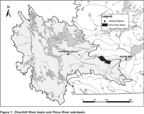
As a preliminary step to modeling the Lower Churchill watershed, the Pinus River sub-basin was selected for study (). This basin was chosen partly due to the existence of a streamflow gauge that has been in operation since 1998, the data from which can be used for calibrating the hydrological model. Four other hydrometric stations in the Churchill River basin have records of sufficient length to be considered for this work. Two of these are in regulated watersheds, making model calibration difficult without naturalized flows. The third station was not chosen as it is located at the mouth of a large lake that provides significant attenuation to flows, and while these might be negligible over long time frames, details on the elevation-volume relationship and outflow characteristics of the lake are not known. The fourth station was not chosen because it lies in a basin with very flat headlands and the drainage divide is difficult to delineate based on the 1:50000 scale used. The Pinus River does not have any of the above complications. The watershed area upstream of the streamflow gauge is approximately 770 km2. The Pinus connects to the Churchill River between Gull Island and Muskrat Falls.
Figure 1. Churchill River basin and Pinus River sub-basin.
Previous Hydrological Forecasting
Short- and medium-term forecasts along with long-term projections of reservoir inflow are important for every hydroelectric development. Short-term forecasts consist of hourly predictions required for decisions on operational efficiency, while medium-term forecasts can range from days to weeks and even months ahead (Li et al., Citation2009). Longer-term projections are important for larger reservoirs with multi-year storage potential. Projections on a multi-decadal scale, including those discussed in this paper, are fundamental for the planning of future hydroelectric developments such as the Lower Churchill Project.
Expected changes in Labrador streamflow under future climate conditions can be broadly assessed using projections from the Intergovernmental Panel on Climate Change's (IPCC) Technical Paper VI - Climate Change and Water, which describes the effects of climate change on the global hydrological cycle (Bates et al., Citation2008). The IPCC used a multi-model ensemble, based on the SRES A1B emissions scenario (IPCC, Citation2000), to simulate projected changes in runoff from the base period 19801999 to the future 20802099. Based on projections in Bates et al. (Citation2008), Labrador can expect between a 10 and 20% increase in mean runoff, with at least 80% of the models used in the ensemble agreeing with the direction of change. Unfortunately, due to the coarse resolution of the models used in that study, the results represent a very broad scale and it is impossible to determine local effects. As such, it is prudent for any hydroelectric developer to investigate local influences and details related to the time evolution of these changes.
Data Sources
NARCCAP
The North American Regional Climate Change Assessment Program (NARCCAP) is an international collaboration, which aims to investigate the uncertainties in future climate projections on the regional level (Mearns et al., Citation2007, Citation2009). NARCCAP data include a selection of regional climate models (RCMs) nested within multiple atmosphere-ocean general circulation models (GCMs). Each GCM is driven by the SRES A2 scenario, which falls on the higher CO2 emissions end of the IPCC emissions scenario spectrum (IPCC, Citation2000). NARCCAP's ensemble approach allows for representation of uncertainties introduced by GCM choice, often found to have the greatest impact on uncertainty (Minville et al., Citation2008), RCM choice, and their respective structural formulations (Maraun et al., Citation2010). Unfortunately, other important sources of uncertainty, including those related to choice of emissions scenarios, various parameter settings, natural variability induced by choice of initial conditions, and spatial resolution (Kotlarski et al., Citation2005), are not represented.
The timeframes covered are from 1968 to 2000 for the base period, and from 2038 to 2070 for the future period, including three years of model spin up data at the beginning of each run, which are not included in this analysis. Due to budget constraints not all possible RCM-GCM combinations are being run by NARCCAP. Each GCM will eventually be coupled with half the RCMs, and each RCM will be coupled with half of the GCMs, resulting in a representative sample of 12 simulations (both future and current). The results of all 12 simulations were not ready for distribution at the time this work was conducted and, as such, this study samples six of the seven available data sets, shown in and . (The only available data set that was not incorporated in this study is HRM3-HadCM3, due to inconsistencies arising from HadCM3's 360-day year). The six ensemble members considered in this study use a variety of grid sizes and map projections, vertical coordinate systems and number of vertical levels, dynamics and physics schemes, land surface schemes and vegetation classes, and time steps among other varying parameters and characteristics (University Corporation for Atmospheric Research (UCAR), Citation2007).
Table 1. Details of NARCCAP's RCMs and GCMs.
Table 2. NARCCAP ensemble members used.
The output from these models was bias corrected and used as input for the WATFLOOD hydrological model (Kouwen et al., Citation1993), from which daily streamflow values were obtained for the base and future periods.
Observed Data
To independently validate the RCM-GCM results, the base period output was compared to Adjusted Historical Canadian Climate Data (AHCCD) precipitation data (Mkis and Hogg, Citation1999) and Environment Canada's surface air temperature station data for Goose Bay, Labrador (referred to herein as observed data). AHCCD precipitation data were used because of the persistent problem of wind-induced undercatch by precipitation gauges. The AHCCD temperature data were not used as the data were found to be very similar to actual gauge measurements. While some gridded data sets are available for the region of interest (e.g., CANGRID, which uses AHCCD data, but only covers up to 1990; or Agri-Geomatics which covers up to 2003, but does not use corrected data and does not have the required mean daily temperature data), the AHCCD precipitation and measured temperature data for Goose Bay were selected because they are thought to provide the most accurate and complete weather record for the study region.
Biases were found between base period simulations and the observed data for both precipitation and temperature, with the largest biases occurring for precipitation and in winter. The bias correction process and results are discussed in detail later.
WATFLOOD Hydrological Model
WATFLOOD is a grouped response unit based numerical hydrological model (Kouwen et al., Citation1993), which is suitable for short-term flood forecasting (Cranmer et al., Citation2001) and has been shown to effectively translate climate patterns from corrected climate model data into hydrological responses (Sung et al., Citation2006; Dibike and Coulibaly, Citation2007). WATFLOOD uses conceptual equations to represent vertical water budget processes and a physically-based model for horizontal routing processes (Bingeman et al., Citation2006).
WATFLOOD can be considered a hydrological model of intermediate complexity. It represents water balances well but does not represent energy-related processes, such as evaporation, with the same degree of sophistication. An advantage of the simplistic representation of energy processes is that only precipitation and temperature data are required as inputs. Thus, the evaporation component, which employs Hargreaves equation, ignores the effects of humidity, wind and radiation. Despite this simplification, a useful result is achieved for the purpose of comparing average flows in different climate periods.
WATFLOOD Calibration
As there are no climate observation stations in the Pinus River basin, precipitation and temperature data from nearby Goose Bay, approximately 90 km east of the basin centroid, were used for WATFLOOD calibration. There was a slight lapse adjustment made to the observed Goose Bay temperature data to compensate for the difference in elevation between the two locations the Goose Bay climate station is at an elevation of approximately 50 m, whereas the Pinus River basin has an elevation range of between 360 and 480 m, resulting in colder temperatures in the Pinus River basin.
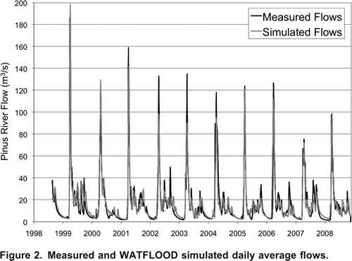
More than ten years (1998 to 2008) of measured daily streamflow data on the Pinus River were available from the Water Survey of Canada for WATFLOOD model calibration. The intent of the calibration, which was based on the mean annual cycle streamflow values of the observation record (not shown), was not to fit the measured daily flows exactly, but rather to reproduce the climate signal (i.e., monthly average flows, timing of spring runoff, baseflow recession periods, etc.). As with any model, the chosen hydrological model cannot give a full picture of reality; however, it is important that the model represents well the main features of the system dynamics relevant to the particular study (Dibike and Coulibaly, Citation2007). As such, the model was calibrated using monthly summaries of the measured data alone and validated against the ten years of daily hydrometric data, as shown in . Good agreement was found with the daily results. The Nash-Sutcliffe model efficiency coefficient (Nash and Sutcliffe, Citation1970) for the validation was 0.80, while the r2 correlation coefficient was 0.81. These were deemed acceptable values for the purpose of climate change impacts assessment on average basin flows.
Figure 2. Measured and WATFLOOD simulated daily average flows.
Due to the short period of record of the hydrometric gauge and the approximate nature of the calibration, no additional data were used for a separate model validation. If this model continues to be used for impacts research, additional years of streamflow data should be withheld from the monthly calibration process to perform a separate, more independent, model validation based on unseen daily measurements. For now, the validation is not fully independent since the model has already seen the monthly summaries of the data through calibration.
RCM-GCM Bias Corrections
Each of the six ensemble members was found to have varying biases in both temperature and precipitation for the location of interest. In particular, there is a relatively consistent cold bias throughout the year (likely due in part to the elevation difference between the RCM grid spaces used and the observation station in Goose Bay), while winter precipitation is greatly underestimated.
Several studies have shown that in order to achieve realistic results some form of preprocessing is required to remove biases in climate output fields before they can be used to force a hydrological model (Feddersen and Andersen, Citation2005; Hansen et al., Citation2006; Christensen et al., Citation2008; Piani et al., Citation2010). As such, model outputs were corrected to statistically match observations from the same period, the benchmark standard of bias correction procedure acceptability (Wood et al., Citation1997). These corrections, as described in detail below, were then applied to the corresponding future periods.
Precipitation Bias Correction
While linear scaling corrections are commonly used for bias correction, Leander and Buishand (Citation2007) found that a simple nonlinear transformation, first used by Shabalova et al. (Citation2003), which corrects both mean and coefficient of variation (CV), leads to a better reproduction of observed precipitation. Leander and Buishand (Citation2007) recommended a straightforward linear approach for correcting bias in the mean and variance of temperature. While they suggested that basin averages be used in the bias corrections there are no observation stations within the Pinus basin. As such, data from the nearby Goose Bay station were compared to the RCM grid points closest to Goose Bay.
Corrected precipitation values were determined using Equation
Equation 1
.
where P* is the corrected precipitation, P is the uncorrected model precipitation, and a and b are the correction parameters corresponding to mean and CV, respectively. To reduce sampling variability, these factors were determined for 5-day periods (73 periods throughout the year) using data from the 30 preceding and 30 proceeding days, and averaging over the entire base period (1971-2000). Parameter b was first determined iteratively by ensuring that the CV of the corrected precipitation matched that of the observed. Then parameter a, which depends on the value of b, was determined by matching the means of the corrected and observed precipitation.
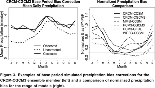
shows the impact of the bias correction on the CRCM-CGCM3 ensemble member for the base period simulation along with a comparison of each model's normalized precipitation bias. By inspection it is apparent that the corrected precipitation is a much better fit to observations than the uncorrected data. It is also evident that precipitation biases are consistently greatest in the cold season.
Figure 3. Examples of base period simulated precipitation bias corrections for the CRCM-CGCM3 ensemble member (left) and a comparison of normalized precipitation bias for the range of models (right).
Temperature Bias Correction
The temperature bias corrections were completed using Equation
Equation 2
, simplified from Leander and Buishand (Citation2007):
where T* is the bias-corrected temperature, T
RCM
is the uncorrected model temperature, T
obs
is the observed data, is the climatological average temperature for each 5-day period, and is the standard deviation. Reducing sampling variability was achieved in a manner identical to the precipitation bias correction. There was no need for spatial averaging.
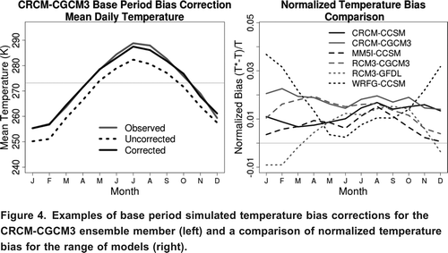
A typical example of the bias correction for CRCM-CGCM3 is found in , along with a comparison of the ensemble's normalized temperature biases. Similar to precipitation, it is apparent that the corrected temperature data are a much better fit to observations than the uncorrected data. The normalized temperature biases show that the variability of biases between ensemble members is greatest in the cold season.
Figure 4. Examples of base period simulated temperature bias corrections for the CRCM-CGCM3 ensemble member (left) and a comparison of normalized temperature bias for the range of models (right).
Bias Correction Assumptions
When applying a bias correction derived from the comparison between base period model output and observations to some future period, it is assumed that the correction will still be valid for a future, potentially different, climate. Unfortunately, this necessary assumption of stationary seasonality cannot be validated or invalidated until the future timeframe is upon us (Trenberth et al., Citation2003).
The bias correction method discussed above uses a two-month correction window as it moves over the data. While there may be some time bias due to the potential future shifting of seasons, there is a significant overlap that helps to mitigate any negative influence potential non-stationarity may have.
Bias correction is imperfect; however, it remains a useful and necessary tool for determining the climatic changes in hydrological regimes between current and future timeframes.
Alternatives
Other methods for addressing model bias include statistical downscaling and numerical weather generators. CitationRahman et al. (2012) applied such concepts for assessing the impacts of climate change on a southern Ontario watershed. Sushama et al. (Citation2006) did not apply any bias correction methods and simply analyzed the differences between the base period and future period model outputs, while Minville et al. (Citation2008) used a combination of the change factor method and a stochastic weather generator. See Themel et al. (Citation2011) for a thorough comparison of various precipitation bias correction and statistical downscaling techniques. Leander and Buishand's (Citation2007) corrections was chosen because of its simplicity and effectiveness.
Bias Corrected Climate Simulation Results
In this section, the base and future period results of the precipitation and temperature bias corrections are presented alongside observations.
Simulated Precipitation
Corrected mean results of the precipitation simulation ( and ) show that monthly precipitation is consistently higher in the future period simulations than in the base period, except for a small decrease in October. The largest increases occur in winter, with an increase of almost 25% in February, while the smallest increases occur in spring, typically around 6%. The mean simulated base period precipitation and observed precipitation are both 3.1 mm/day, while the mean simulated future precipitation is 3.4 mm/day, representing over a 9% increase.
Figure 5. Changes in daily precipitation from simulated base period to future period. Ensemble mean represented by thick black line.
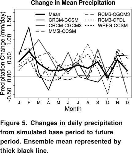
Table 3. Mean monthly and annual changes in precipitation rates.
Individual ensemble members show a high variability of precipitation change, with a difference of over 1 mm/day in some months. This illustrates the importance of using an ensemble approach some uncertainty was exposed in the simulations, represented by the different climate realizations and manifested as a range of possible changes in monthly precipitation rates. It also indicates that the mechanisms involved in simulating rainfall are not robust or consistent across the various RCMs and GCMs. When looking at the variability of mean change projected by any particular GCM or RCM (e.g., CCSM paired with three different RCMs or CRCM paired with two different GCMs), the same overall pattern of inconsistency emerges.
Probability density functions (pdfs) of corrected and uncorrected base and future period simulated precipitation from the ensemble members are plotted with the observed precipitation in . It is assumed that each ensemble member projection has an equal probability of occurrence and that each day within respective projections has equal likelihood of being representative. All pdfs were created using a smoothed empirical distribution with Gaussian kernel density estimation. The probability that the precipitation rate, in , will be below a given value is represented by the area under the curve to the left of said value. As such, the total area under a pdf is equal to one, while there is equal likelihood (50%) that the precipitation rate could be above or below the median value. The units of density on the y-axis are the inverse of the x-axis units (e.g., for precipitation rate, density units are (mm/day)1).
Figure 6. Probability density functions for ensemble daily mean (top left), five-day mean (top right), monthly mean (bottom left) and annual precipitation rates (bottom right).
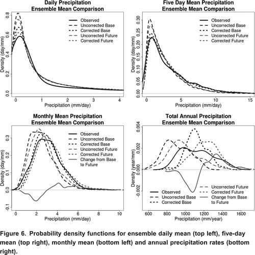
shows there can be appreciable variation in total precipitation from day-to-day, month-to-month and year-to-year within any simulated period. This implies that even though the mean precipitation is expected to increase, any given future period year could have less accumulated precipitation than a base period year. This variability is important to keep in mind when using simulation results in impact studies.
The four plots in are the distributions for mean daily, five-day, monthly and annual precipitation. Haerter et al. (Citation2011) showed that bias correction improvements are limited to the specific timescale at which the corrections take place; in this study the bias correction focuses on a five-day timescale. Qualitatively the five-day pdf for the corrected base period matches the observations fairly well, as do the daily and monthly timescales. However, while the mean of the corrected base period annual timescale is aligned with observations, the year-to-year variance is lower, indicating that the models do not sufficiently capture interannual variability and that the bias correction is unable account for it. Another contributing factor to the discrepancy is that for the annual timescale pdf, there are significantly fewer data points available for the creation of pdfs - only 30 for observations and 172 for the entire ensemble (not all ensemble members have full 30 year runs available, which is why the total is not 180), while the daily, five-day and monthly have 62,780, 12,556 and 2,064 points, respectively. In other words, the simulated and observed pdfs might match better if more data points are available, especially for the observed data set. A similar pattern is found in temperature and streamflow pdfs presented later.
The difference between the base and future period precipitation is shown in the monthly and annual plots. By inspection it is apparent that there will be fewer months and years with less precipitation and more months and years with greater precipitation, contributing to the overall increase in precipitation discussed earlier.
Simulated Temperature
Similar to precipitation, mean monthly temperature is found to increase from base period to future period simulations. As shown in and the corresponding , the greatest temperature increases occur between November and February, averaging roughly 3.5 K, while the rest of the year experiences a steady mean temperature increase of roughly 2.0 K. As with precipitation, projected monthly changes in temperature vary between individual ensemble members (), with the lowest variation occurring in late winter. All ensemble members agree that there will be a temperature increase in each month. The mean annual temperature for the base period simulation is 272.6 K (compared to the observed 272.8 K), while the mean annual temperature for the future period is 2.6 K warmer at 275.2 K.
Figure 7. Mean change in temperature from base to future period simulations.
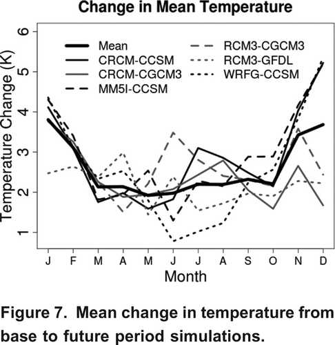
Table 4. Mean monthly and annual increases in temperature.
February and March appear to have the strongest consensus across all ensemble members in terms of the change in mean temperature, indicating that the temperature change projections for these two months is relatively robust. There is a consistency across CCSM driven ensemble members, except for June, July and August, indicating that throughout most of the annual cycle there is relatively little uncertainty introduced by the RCM. CGCM3 is less consistent, suggesting a heavier RCM influence on mean temperature change. Both CRCM simulations are in good agreement, except for November and December, implying that in this particular case the GCMs contribute less to uncertainty. RCM3 sees a variety of good and poor agreement throughout the year, which may be an indication of similar amounts of uncertainty introduced by both RCM3 and the driving GCMs.
The mean daily, five-day, monthly and annual temperature pdfs in provide further insight into the projected temperature changes. In particular, there is relatively little overlap between the corrected base and future simulations on an annual timescale, indicating that the majority of years in the future are projected to be warmer than most of the warmest base period years. The Change from Base to Future line in the annual plot highlights this. Similarly, for the monthly timescale, though there is some variability as to the direction of change for non-extreme months, it is apparent that there will be fewer months with very cold temperatures and more months with higher temperatures.
Figure 8. Probability density functions for ensemble daily mean (top left), five-day mean (top right), monthly mean (bottom left) and annual temperature (bottom right).
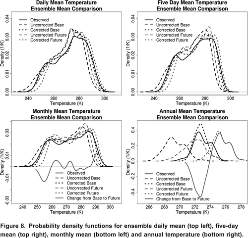
As with precipitation, the annual mean simulated temperature has a slightly lower variability than the observed. Differences in the pdf shapes are due to reasons discussed previously.
Results
Using the corrected results corresponding to the Goose Bay grid coordinates from the base and future period climate simulations, discussed above, as inputs to the WATFLOOD hydrological model, streamflow for the two timeframes was simulated. In this section a comparison of mean hydrographs, annual and seasonal flows are presented.
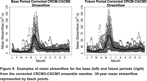
An example (CRCM-CGCM3) of the simulated daily streamflow values (grey) along with the 30-year means (black) for both timeframes is shown in . It is clear from these plots that while the mean hydrograph is a useful indicator of climatic norms there is notable variance from year to year, especially in the peak spring flows. Differences in base and future period plots are discussed below.
Figure 9. Examples of mean streamflow for the base (left) and future periods (right) from the corrected CRCM3-CGCM3 ensemble member. 30-year mean streamflow represented by black points.
Mean Hydrographs
The differences between the ensemble mean base and future period simulated hydrographs, along with the simulated hydrograph based on observed data are shown in and the corresponding . (The observed hydrograph in and all subsequent hydrographs refer to the WATFLOOD hydrographs simulated using observed climatological variables as input.) There are four noteworthy changes from the mean base period to the future period simulations:
| 1. | The spring melt, spanning April, May and June, occurs roughly two weeks earlier, although it appears to be slightly smaller in magnitude. April experiences the highest increase of any month, over 109%, caused by the earlier onset of the spring melt. As a result of earlier melt, June is simulated to have a 33% decrease in streamflow. | ||||
| 2. | November to March streamflow increases substantially. | ||||
| 3. | July to October streamflow exhibits no substantial change. | ||||
| 4. | On a mean annual basis, streamflow increases by 8.9%, from 17.6 to 19.2 m3/s. | ||||
Figure 10. Comparison of 30-year ensemble mean simulated base and future period streamflow (left) and the change in 30-year ensemble mean simulated streamflow (right), from base to future period.
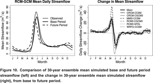
Table 5. Mean monthly and annual changes in streamflow.
While there is some inter-model variability throughout the year, the variability of change in spring melt signal is most noticeable. MM5I-CCSM and WRFG-CCSM both show large changes in the spring melt; the former shows an increase and the latter a decrease. One can infer from the difference between these simulations that uncertainty in the projection of the spring melt magnitude is largely due to the RCM rather than the GCM, as both models are driven by CCSM.
To determine whether there is a statistically significant difference between the base and future periods, a Wilcoxon Rank Sum Test was performed using each individual monthly mean from all six ensemble members. This test was chosen due to the skewed distribution of the mean monthly streamflow values. The results, shown in , indicate that there is a difference, statistically significant to 1%, for the months of November through June, as indicated by the p-value (p-values less than 0.01 imply a statistical significance level of 1%). The remaining four months are significantly different between the base and future periods, while mean annual streamflow is significantly higher.
The individual hydrographs produced by the six ensemble members were examined qualitatively to assess whether the results are consistent across all ensemble members. In , each ensemble member shows that the spring melt begins earlier, winter streamflow increases, and late summer and fall streamflow remains relatively unchanged. The magnitude of the spring melt decreases for two thirds of the ensemble members.
Figure 11. Mean base and future period simulated hydrographs for the six ensemble members.
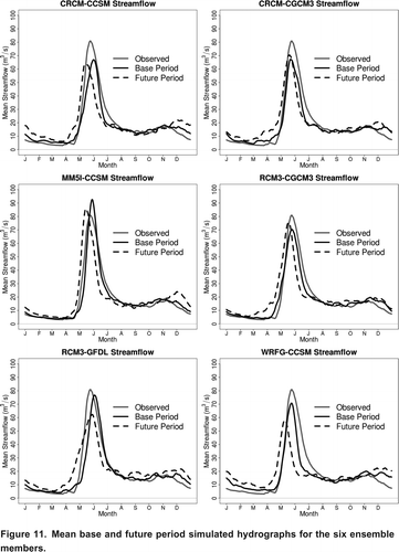
From , the mean observed hydrograph can be compared to the mean base period hydrographs from the ensemble members. Initial inspection reveals that while the ensemble members do not reproduce perfectly the observed hydrograph, they represent the main features of the annual cycle (e.g., winter base flow, spring melt, etc.) fairly well, particularly the MM5I-CCSM hydrograph. Many RCM driven hydrographs illustrate noticeable differences from the observed - similar in magnitude to the climate change signal. This is consistently the case for December streamflow and is also prevalent in the timing and magnitude of the spring melt. While the results are still useful for investigating the relative changes between base and future period simulations, caution should be used when interpreting absolute changes. Further comparison and discussion is found below.
Distribution of Annual and Seasonal Mean Flows
While the simulated mean changes are informative, it is important to consider the distributions of the results to gain a more useful and robust understanding of the potential impacts of climate change. and show the pdfs for mean annual and seasonal flow, respectively, including a comparison between base period ensemble member results and observed. Even though there is significant overlap in the mean annual flows there is a clear increase in magnitude from the base to the future period, as quantified in . The ensemble mean is similar to that of the observed hydrograph; however, the latter has a greater spread of values, most notably in the higher range flow rates. This is likely a propagation of the precipitation and temperature bias correction timescale issues discussed previously.
Figure 12. Probability density functions of mean annual flows for ensemble members during the base period (left) and the ensemble means (right) for base and future periods.
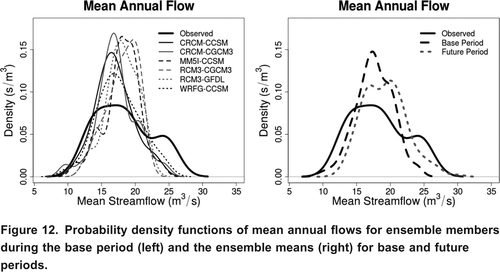
Figure 13. Probability distribution functions for mean winter (November to March), spring (April to June) and summer (July to October) flows for the ensemble members (left), and the ensemble mean (right).
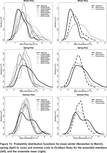
By considering seasonal flows better insight can be gained concerning the timing of significant changes in streamflow. The changes in mean winter (November to March) flow magnitude are statistically significant (p-value = 1.7 108), while changes in spring (April to June) and summer (July to October) are not (p-values of 0.24 and 0.79, respectively). In all three seasons, the pdfs become flatter and wider from base to future periods, indicating higher variability in the future.
There is greatest agreement amongst ensemble member base period simulations in summer, while winter shows the least agreement. During spring and summer, the ensemble member distributions are slightly to the left of the observed indicating a small underestimation of flow, while the opposite is true of winter.
Discussion
Various amounts of bias in both precipitation and temperature were identified for each of the six ensemble members. The greatest magnitudes and variances of bias between ensemble members occurs in the cold season, while the opposite is true in the warm season. WRFG-CCSM appears to have the largest overall precipitation bias for the region of interest, while RCM3-GFDL has the lowest. Most of the temperature biases found are relatively consistent throughout the year, with the exception of WRFG-CCSM and RCM3-GFDL whose biases appear more seasonal. The bias corrections brought the base period simulations for all ensemble members in line with observations. The mean annual bias corrected simulated precipitation is 3.1 mm/day, while observations also suggest an average of 3.1 mm/day; the mean annual bias corrected simulated temperature is roughly 272.6 K, while observations suggest an average of 272.8 K.
Climate simulations suggest that both mean annual precipitation and temperature will increase from the base period to the future period, with greater increases expected during the cold season. Based on WATFLOOD simulations of the Pinus River basin, the increase in precipitation over the span of a year will have a greater impact on streamflow than increased evaporation that accompanies higher temperatures, resulting in a 8.9% mean increase in streamflow. This is an expected result for the latitude of the study region; intensification of the hydrological cycle is expected to accompany climate change and most of the moisture in the atmosphere deposited as precipitation over Labrador originates from lower latitudes, thousands of kilometres away (Bates et al., Citation2008; Trenberth, Citation1998). However, if only July through October are examined, where there is no statistically significant mean increase in streamflow, then the increase in precipitation appears to be balanced by increased evaporation and other processes in the simulation.
The mean annual increase in simulated streamflow corresponds well with previous work by Bates et al. (Citation2008), which predicts a 10 to 20% increase in streamflow by the years 20802099. The Bates et al. simulation follows the SRES A1B scenario, which assumes a path for atmospheric carbon dioxide concentrations similar to that of the A2 scenario to the middle of the 21st century, after which the A1B scenario becomes more conservative (IPCC, Citation2000).
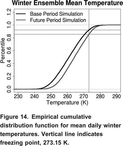
Considering the mean flow by season (as previously defined), the simulations show that summer experiences no significant change in streamflow, while winter experiences a statistically significant increase. This increase can be partly explained by the increase in winter precipitation from 2.9 mm/day to 3.3 mm/day. For this additional precipitation to translate into streamflow there needs to be an increase in the amount of time temperature is above freezing. shows the empirical cumulative distribution functions (ecdf) for mean daily winter temperature. From the intersections of the ecdfs with the vertical line representing the freezing point, it is apparent that the percentage of days with mean temperatures below freezing decreases from 92.1% to 85.4%, from the base to the future period. In other words, the amount of time above freezing temperatures in the winter nearly doubles in the future.
Figure 14. Empirical cumulative distribution function for mean daily winter temperatures. Vertical line indicates freezing point, 273.15 K.
While mean spring flow and the magnitude of the peak spring flow experience no significant change, the timing of the spring melt occurs earlier by roughly two weeks. These results correspond with previous work by Bourque and Simonet (Citation2008), which projects a higher mean winter flow and an earlier spring melt for a northern Quebec watershed. Higher winter temperatures contribute to an increase in runoff throughout the winter, leaving less water trapped in the snowpack to generate the spring melt. There is, however, a mean increase in precipitation throughout the winter, which acts to enhance the snowpack volume. These competing factors provide insight into why some ensemble members suggest an increase in the volume of mean and peak melt, while others show a decrease, resulting in no statistically significant change.
Sources of Uncertainty
An unavoidable assumption that must be made when using future climate projections from a model validated by comparison to the current climate is that the relationship between model output and reality will remain stationary. While bias corrections ensure statistical consistency between base period model output and observations, the process is not physically-based and it is necessary to assume that the validity of statistical corrections will also remain stationary in future climates.
By incorporating six different RCM-GCM combinations in this study, a broader understanding of the uncertainty of the simulations introduced by the RCMs and GCMs is developed, and thus a more useful approximation of mean changes in precipitation, temperature and streamflow is produced. However, this approach does not capture the full range of uncertainty that would be introduced by different emissions scenarios, other climate and hydrological models not included in the study, as well as factors and processes that may be poorly represented in the models used.
By examining the range of NARCCAP's projected precipitation and temperature changes ( and ) a measure of uncertainty, introduced by the various RCMs and GCMs, is apparent. There is a wide spread of values projected throughout the year for precipitation, indicating that caution should be used if applying only the ensemble mean in an impact study as there is a range of equally likely realizations of potential future precipitation. There was good agreement in late winter for temperature change projections, indicating that the ensemble mean is robust for that time of year, while the rest of the year showed a much wider spread.
Upon closer examination of individual RCMs and GCMs it becomes apparent that there is a level of uncertainty introduced by both the regional models and their driving GCMs. For example, in temperature change projections, all three CCSM runs (CRCM, MM5I and WRFG) have strong agreement throughout the year, indicating that relatively little uncertainty is introduced by the RCMs; however, the wider variety of CCSM precipitation change projections indicate that the RCMs introduce appreciable uncertainty. Agreement between ensemble member projections for both precipitation and temperature vary throughout the annual cycle, signifying that model uncertainty is dependent on the time of year.
There is also uncertainty introduced by using a hydrological model that relies primarily on temperature (Hargreaves equation) to simulate evapotranspiration. While WATFLOOD was adequately calibrated to the energy processes of the current climate, non-stationary future conditions may result in less accurate hydrological simulations. In order to capture the uncertainty of using an empirical evapotranspiration routine it would be necessary to use a hydrological model of greater complexity, with a more physically-based representation of the land-surface energy balance.
Conclusions and Recommendations
The results of this study indicate there will be a mean annual increase in streamflow of nearly 9% in the Pinus River sub-basin, from the base period (19712000) to the future period (20412070). This increase is expected to manifest itself primarily as an increase in cold season (November to April) streamflow, caused by higher precipitation and temperatures over the same period. Conversely, no significant change in streamflow is expected to occur from July through October. Some simulated hydrograph features, namely December flow and the precise timing and magnitude of spring melt, should be interpreted with caution as differences between base period simulations and observations are often of similar magnitude to the climate change signal.
The WATFLOOD hydrological model was driven by bias corrected RCM-GCM combinations from six ensemble members. The ensemble mean of the bias corrected climate output suggests a mean annual increase in precipitation of nearly 0.3 mm/day and a mean annual temperature increase of roughly 2.6 K. Both precipitation and temperature increases are greatest during the cold season.
The range of results in mean projections from different ensemble members demonstrates the uncertainty introduced by various RCMs and GCMs, while the probability density functions provide a probabilistic measure of climate variability. These measures of uncertainty and climate variability must be kept in mind when conducting impact studies, as simply employing the mean results ignores the range of possible outcomes.
The following list is recommended work that will contribute to a more complete understanding of the impacts that climate change may have on the Lower Churchill Hydroelectric Generation Project:
| • | Include more NARCCAP ensemble members as they become available to more effectively capture the range of uncertainty introduced by RCMs and GCMs. The inclusion of models driven by other emissions scenarios should also be considered; however, only the A2 scenario is available through NARCCAP, so another data source would be required. | ||||
| • | As an alternative to the bias correction process used in this paper, attempt a statistical downscaling approach that includes stochastic weather generation or some method that is able to accurately reproduce the short and long timescales of the observed data. | ||||
| • | Expand the hydrological modeling to the entire Churchill River watershed. Additional climate and streamflow measuring stations for model calibration would be invaluable in this effort. | ||||
| • | Consideration should be given to the use of a more complex hydrological model that is able to more effectively represent energy balance processes. | ||||
| • | As this study focused primarily on mean streamflow, there should be some effort to examine the effects of climate change on extreme hydrological conditions, such as floods and droughts, in the Churchill River watershed. | ||||
| • | A reservoir or power generation model should be used to determine how the altered flow regimes might translate into changes in potential power production. | ||||
Acknowledgements
This study was part of a broader study at Memorial University in collaboration with Nalcor Energy that is examining the effects of climate change on the Lower Churchill Hydroelectric Generation Project. This work would not be possible without the generous financial support of Nalcor. In particular, the collaborative efforts of Marion Organ have been tremendously valuable. We would like to recognize Dr. Nicholas Kouwen for his help with setting up and running WATFLOOD. We would also like to thank NSERC for providing financial support. We wish to thank the North American Regional Climate Change Assessment Program (NARCCAP) for providing access to the data used in this study. NARCCAP is funded by the National Science Foundation, the U.S. Department of Energy, the National Oceanic and Atmospheric Administration, and the U.S. Environmental Protection Agency Office of Research and Development. Finally, we thank the two anonymous reviewers for providing valuable feedback and suggestions.
References
- Bates, B. C., Z. W. Kundzewicz, S. Wu, and J. P. Palutikof (ed.). 2008. Climate change and water. Technical Paper of the Intergovernmental Panel on Climate Change. Geneva: IPCC Secretariat, 210 pp.
- Bingeman , A. K. , Kouwen , N. and Soulis , E. D. 2006 . Validation of the hydrological processes in a hydrological model . Journal of Hydrologic Engineering , 11 : 451 – 463 .
- Bourque, A., and G. Simonet. 2008. Quebec. In From impacts to adaptation: Canada in a changing climate 2007. Ottawa: Government of Canada, pp. 171226.
- Christensen , J. H. , Boberg , F. , Christensen , O. B. and Lucas-Picher , P. 2008 . On the need for bias correction of regional climate change projections of temperature and precipitation . Geophysical Research Letters , 35 : L20709
- Christensen , J. H. and Christensen , O. B. 2007 . A summary of the PRUDENCE model projections of changes in European climate by the end of this century . Climatic Change , 81 : 7 – 30 .
- Christensen , N. S. , Wood , A. W. , Voisin , N. , Lettenmaier , D. P. and Palmer , R. N. 2004 . The effects of climate change on the hydrology and water resources of the Colorado River basin . Climatic Change , 62 : 337 – 363 .
- Cranmer , A. J. , Kouwen , N. and Mousavi , S. F. 2001 . Proving WATFLOOD: Modelling the nonlinearities of hydrologic response to storm intensities . Canadian Journal of Civil Engineering , 28 : 837 – 855 .
- DesJarlais, C., A. Bourque, R. Dcoste, C. Demers, P. Deschamps, and K.-H. Lam. 2004. Adapting to climate change. Montreal: Ouranos, 83 pp.
- Dibike , Y. B. and Coulibaly , P. 2005 . Hydrologic impact of climate change in the Saguenay watershed: Comparison of downscaling methods and hydrologic models . Journal of Hydrology , 307 : 145 – 163 .
- Dibike , Y. B. and Coulibaly , P. 2007 . Validation of hydrologic models for climate scenario simulation: The case of Saguenay Watershed in Qubec . Hydrological Processes , 21 ( 23 ) : 3123 – 3135 .
- Feddersen , H. and Andersen , U. 2005 . A method for downscaling of seasonal ensemble predictions . Tellus , 57A : 398 – 408 .
- Filion , Y. 2000 . Climate change: Implications for Canadian water resources and hydropower production . Canadian Water Resources Journal , 25 : 255 – 269 .
- Haerter , J. O. , Hagemann , S. , Mosely , C. and Piani , C. 2011 . Climate model bias correction and the role of timescales . Hydrology and Earth System Sciences , 15 : 1065 – 1079 .
- Hansen , J. W. , Challinor , A. , Ines , A. , Wheeler , T. and Moron , V. 2006 . Translating forecasts into agricultural terms: Advances and challenges . Climate Research , 33 : 27 – 41 .
- Intergovernmental Panel on Climate Change IPCC. 2000. Emissions scenarios, ed. N. Nakicenovik, and R. Swart. UK: Cambridge University Press, 570 pp.
- Kotlarski , S. , Block , A. , Bhm , U. , Jacob , D. , Keuler , K. , Knoche , R. , Rechid , D. and Walter , A. 2005 . Regional climate model simulations as input for hydrological applications: Evaluation of uncertainties . Advances in Geosciences , 5 : 119 – 125 .
- Kouwen , N. , Soulis , E. D. , Pietroniro , A. , Donald , J. and Harrington , R. A. 1993 . Grouped response units for distributed hydrologic modeling . Journal of Water Resources Planning and Management , 119 : 289 – 305 .
- Leander , R. and Buishand , T. A. 2007 . Resampling of regional climate model output for the simulation of extreme river flows . Journal of Hydrology , 332 : 487 – 496 .
- Li , H. , Luo , L. , Wood , E. F. and Schaake , J. 2009 . The role of initial conditions and forcing uncertainties in seasonal hydrologic forecasting . Journal of Geophysical Research , 114 : D04114
- Maraun, D., F. Wetterhall, A. M. Ireson, R. E. Chandler, E. J. Kendon, M. Widmann, S. Brienen et al. 2010. Precipitation downscaling under climate change: Recent developments to bridge the gap between dynamical models and the end user. Reviews of Geophysics 48. doi:10.1029/2009RG000314.
- Mearns, L. O. et al. 2007, updated 2011. The North American Regional Climate Change Assessment Program dataset. National Center for Atmospheric Research Earth System Grid data portal, Boulder, CO. http://www.earthsystemgrid.org/browse/viewProject.htm?projectId=ff3949c8-2008-45c8-8e27-5834f54be50f (accessed September 2010).http://www.earthsystemgrid.org/browse/viewProject.htm?projectId=ff3949c8-2008-45c8-8e27-5834f54be50f
- Mearns , L. O. , Gutowski , W. , Jones , R. , Leung , R. , McGinnis , S. , Nunes , A. and Qian , Y. 2009 . A regional climate change assessment program for North America . EOS , 90 ( 36 ) : 311 – 312 .
- Mkis , E. and Hogg , W. D. 1999 . Rehabilitation and analysis of Canadian daily precipitation time series . Atmosphere-Ocean , 37 : 53 – 85 .
- Minville , M. , Brisette , F. , Krau , S. and Leconte , R. 2009 . Adaptation to climate change in the management of a Canadian water-resources system exploited for hydropower . Water Resource Management , 23 : 2965 – 2986 .
- Minville , M. , Brissette , F. and Leconte , R. 2008 . Uncertainty of the impact of climate change on the hydrology of a Nordic watershed . Journal of Hydrology , 358 : 70 – 83 .
- Murphy , J. M. , Sexton , D. M. H. , Barnett , D. N. , Jones , G. S. , Webb , M. J. , Collins , M. and Stainforth , D. A. 2004 . Quantification of modeling uncertainties in a large ensemble of climate change simulations . Nature , 430 : 768 – 772 .
- Muzik , I. 2001 . Sensitivity of hydrologic systems to climate change . Canadian Water Resources Journal , 26 : 233 – 253 .
- Nalcor Energy. 2009. Project planning and description. Vol. 1 Part A of Lower Churchill Hydroelectric Generation Project environmental impact statement, ed. M. Organ. St. John's: Nalcor Energy, 344 pp.
- Nash , J. E. and Sutcliffe , J. V. 1970 . River flow forecasting through conceptual models part I: A discussion of principles . Journal of Hydrology , 10 ( 3 ) : 282 – 290 .
- Piani , C. , Haerter , J. O. and Coppola , E. 2010 . Statistical bias correction for daily precipitation in regional climate models over Europe . Theoretical and Applied Climatology , 99 : 187 – 192 .
- Rahman , M. , Bolisetti , T. and Balachandar , R. 2012 . Hydrologic modelling to assess the climate change impacts in a southern Ontario watershed . Canadian Journal of Civil Engineering , 39 : 91 – 103 .
- Shabalova, M. V., W. P. A. van Deursen, and T. A. Buishand, 2003. Assessing future discharge of the river Rhine using regional climate model integrations and a hydrological model. Climate Research 23: 233246.
- Sung , R. Y.-J. , Burn , D. H. and Soulis , E. D. 2006 . A case study of climate change impacts on navigation on the Mackenzie River . Canadian Water Resources Journal , 31 : 57 – 68 .
- Sushama , L. , Laprise , R. , Caya , D. , Frigon , A. and Slivitzky , M. 2006 . Canadian RCM projected climate-change signal and its sensitivity to model errors . International Journal of Climatology , 26 : 2141 – 2159 .
- Themel , M. J. , Gobiet , A. and Leuprecht , A. 2011 . Empirical-statistical downscaling and error correction of daily precipitation from regional climate models . International Journal of Climatology , 31 : 1530 – 1544 .
- Trenberth , K. E. , Dai , A. , Rasmussen , R. M. and Parsons , D. B. 2003 . The changing character of precipitation . Bulletin of the American Meteorological Society , 84 : 1205 – 1217 .
- Trenberth , K. E. 1998 . Atmospheric moisture residence times and cycling: Implications for rainfall rates and climate change . Climatic Change , 39 : 667 – 694 .
- University Corporation for Atmospheric Research UCAR. 2007. North American Regional Climate Change Assessment Program (NARCCAP). http://www.narccap.ucar.edu/ (accessed June 2012)http://www.narccap.ucar.edu/
- Vasseur, L., and N. Catto. 2008. Atlantic Canada. In From impacts to adaptation: Canada in a changing climate 2007. Ottawa: Government of Canada, pp. 119170.
- Wood , A. W. , Leung , L. R. , Sridhar , V. and Lettenmaier , D. P. 1997 . Non-stationarity in daily precipitation series: Implications for GCM down-scaling using atmospheric circulation indices . International Journal of Climatology , 17 : 439 – 454 .