Abstract
Streamflow data from ten Water Survey of Canada gauging stations were analyzed to characterize streamflow regimes in the Okanagan Basin (British Columbia). The differences in the streamflow regime characteristics of the perennial and intermittent streams were subtle, except for the obvious difference in summer low flows. The intermittent streams tended to have faster recessions after spring freshet, steeper flow duration curves, a slightly earlier median day of the year of the start of the freshet, and more variable discharge in fall. In years with high fall precipitation, discharge was also high during fall for the intermittent streams but in other years it was very low. Discharge on August 15th was lower or similar to streamflow on March 15th for the intermittent stream, whereas it was much higher on August 15th for the perennial streams. These subtle streamflow regime differences point to differences in flow pathways, groundwater contributions to streamflow, and residence times between the intermittent and perennial watersheds, and may have important ecological implications.
Les donnes de dbit d'eau de dix stations de jaugeages opres par les Relevs Hydrologiques du Canada ont t analyss dans le but de caractriser le rgime hydrique des cours d'eau du basin de l'Okanagan (Colombie-Britannique). Les caractristiques hydriques de ces deux catgories des cours d'eau intermittents et prinaux diffrent subtilement, l'exception vidente de l'ample diffrence observe dans les dbits dtiages en t. Les cours d'eau intermittents ont tendance avoir: (1) des dcrues plus rapide aprs la crue printanire, (2) des courbes de dbits-classs plus abruptes, (3) des crues printanires lgrement plus prcoces, selon la journe mdiane d'initiation de la crue et (4) un dbit d'eau plus variable en automne. Les dbits d'eau automnaux du cours d'eau intermittent sont gnralement trs bas, l'exception des annes avec beaucoup de prcipitation. Le dbit du cours d'eau intermittent en date du 15 aot tait moindre ou similaire que le dbit en date du 15 mars, alors que les dbits des cours d'eau prinaux taient beaucoup plus levs le 15 aot. Ces contrastes subtils entre les deux rgimes hydriques peuvent tre attribuables des diffrences soutenues dans les chemins dcoulements, la contribution de l'aquifre au cours d'eau et le temps de sjour, et peuvent avoir d'importantes implications cologiques.
Introduction
Streamflow regimes describe the characteristics of streamflow quantity, timing and variability (Poff et al., Citation1997). They influence channel geomorphology and the distribution and abundance of riverine species (Resh et al., Citation1988; Power et al., Citation1995). Streamflow regimes have a profound influence on the biodiversity of riverine ecosystems (Poff et al., Citation1997; Richter et al., Citation1997; Hart and Finelli, Citation1999; Poff and Zimmerman, Citation2010) because hydrologic variability is important for riverine ecosystem health, structure, and function (Poff and Ward, Citation1989; Datry and Larned, Citation2008; Poff et al., Citation2009). Natural hydrologic variation is integral to biotic diversity within aquatic ecosystems (Arthington and Pusey, Citation2003; Richter et al., Citation1996; Lloyd et al., Citation2003; Poff and Zimmerman, Citation2010). Alterations of natural flow regimes affect the entire riverine ecosystem. For example, modification of timing, duration or magnitude of floods can eliminate spawning cues for fish (Junk et al., Citation1989; King and Louw, Citation1998). An increase in the frequency, duration or rate of change of high streamflow can displace velocity sensitive organisms such as phytoplankton and macroinvertebrates (Allan, Citation1995), each then affect other biotic assemblages in the ecosystem. This has led to a large body of scientific literature advocating the use of natural streamflow regimes as a guide for ecosystem and water resource management (e.g., Poff et al., Citation1997, Citation2009; Richter et al., Citation1997; Stromberg, Citation2001; Nilsson and Svedmark, Citation2002; Hauer and Lorang, Citation2004).
When water resources become scarcer and demand increases, wise water resource management is needed to prevent damaged riverine ecosystems. Billions of dollars are spent annually to restore rivers to their natural state (Palmer et al., Citation2004; Bernhardt et al., Citation2005). Understanding and predicting natural patterns of streamflow in time and space and the associated ecological consequences of altering these patterns of flow variability have thus become fundamental to water resource management (Bunn and Arthington, Citation2002; Arthington and Pusey, Citation2003; Richter et al., Citation2006; Kennard et al., Citation2010). However, many years of observation are generally needed to describe the natural flow regime (Chang et al., Citation2011).
Analysis of the five streamflow regime components (magnitude, frequency, duration, timing, and rate of change of hydrologic conditions) that regulate ecological and physical processes in river ecosystems (Poff and Ward, Citation1989; Walker et al., Citation1995; Richter et al., Citation1996; Poff et al., Citation1997; Greet et al., Citation2011), allows for the characterization of streamflow responses and the hydrologic behaviour of watersheds.
| 1. | Magnitude refers to the discharge and is the amount of water moving past a given point in a given unit of time. Magnitude can be relative or absolute depending on the nature of the research question. Climate, geomorphology and watershed size have a large impact on magnitude. | ||||
| 2. | Frequency describes how often a particular discharge event occurs in a specified period of time. Frequency can be analysed at many different time scales: events based on storms, freshet, or decadal cycles. | ||||
| 3. | Duration is the period of time associated with a specific flow event. Duration can be relative to a particular flow event (e.g., days of flow in a temporary stream) or it can be expressed as a composite, over a specified period of time (e.g., days that flow exceeds the annual mean/median). | ||||
| 4. | Timing or predictability of flows of a specified magnitude is the regularity with which a certain streamflow occurs. This can be defined formally or informally and with reference to different time scales. For example, annual minimum flows may occur with low seasonal predictability or with high seasonal predictability. | ||||
| 5. | Rate of change refers to how quickly discharge changes in magnitude in any given event or seasonally. If a river is stable there is a very slow rate of change, whereas for flashy rivers discharge changes rapidly. | ||||
Streamflow regime analysis provides not only information on flow variability, the magnitude of peak and low flows, and the duration of zero flows, but also on the principle transport frequency of sediment and dissolved load, and possible groundwater or natural storage influences. This information is important for fluvial geomorphologists and hydrologist, and has practical value to stream ecologists (Reece and Richardson, Citation1995; Poff et al., Citation2009). Knowledge about streamflow regimes can also aid in the prediction of streamflow in ungauged basins as streamflow regimes are signatures of the interactions between climate and watershed characteristics. Streamflow regimes for ungauged watersheds can be inferred based on surrounding stations with long-term streamflow records or constructed using geo-statistical or modelling approaches based on the characterization of streamflow regimes in similar (or neighbouring) watersheds (Kennard et al., Citation2010; Sauquet and Catalogne, Citation2011). Moore et al. (Citation2011), for example, used a spatially distributed water balance model to predict inter-catchment variation in annual runoff and the seasonal distribution of runoff in British Columbia (BC). The model was able to distinguish between pluvial, nival and hybrid streamflow regimes and predicted annual runoff with varying levels of accuracy. Sandborn and Bledsoe (Citation2006) used multiple regression models based on data from gauged watersheds and physical and climatic characteristics to predict streamflow regime characteristics in ungauged watersheds in Colorado, Washington and Oregon. Their multiple regression models could predict the magnitude, timing, and rate of change variables quite well but were less successful in predicting streamflow variability. Similarly, Viola et al. (Citation2011) and Saquet and Catalogne (Citation2011) used regression equations to derive flow duration curves for ungauged watersheds in Sicily and France, respectively.
Because very few intermittent streams are monitored for extended periods, little is known about the streamflow regimes of intermittent streams in Canada and how they differ from the flow regimes in neighbouring perennial streams, except for the obvious difference that there are periods of zero flow (Buttle et al., Citation2012). This paper presents an overview of the broad characteristics of streamflow regimes in the Okanagan Basin in British Columbia (BC) using streamflow data from ten Water Survey of Canada (WSC) stations. Specifically, we look at the i) hydrographs and streamflow variability, ii) spring freshet, iii) summer low flows, iv) fall peakflows, and v) cumulative frequency distributions (flow duration curves), and highlight similarities and differences in the magnitude, frequency, duration, timing and rate of change for intermittent and perennial streams. By comparing streamflow regimes of watersheds within a similar climatic region and correlating the streamflow regime characteristics with basic physical watershed characteristics, we aim to improve our understanding of the behaviour of these watersheds and the controls on particular streamflow regime characteristics within the Okanagan Basin. This study is, to our knowledge, the first attempt to characterize perennial and intermittent streams in the Okanagan Basin. These initial results could later be used for regionalization of streamflow regimes to aid prediction in ungauged watersheds in the Okanagan Basin.
Site Description
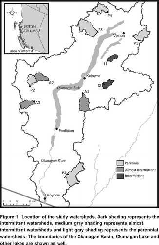
The Okanagan Basin is located in southern BC (). The valley is 510 km wide in the south near Osoyoos, and as wide as 18 km in the north around Armstrong, with a total basin area of approximately 8000 km2. The valley bottom ranges from 416 m above sea level (m asl) near Vernon to as low as 270 m asl in Osoyoos, while the upland alpine tundra is as high as 2400 m asl. Lakes cover much of the valley floor and are fed by perennial and intermittent streams on the surrounding hillslopes. Most of the streams feeding the main valley are in narrow, deeply incised valleys and have steep gradients. These surrounding mountain streams deliver the majority of the water to the Okanagan Basin during the spring freshet. Intermittent streams in the region are understudied but could provide a significant amount of water to the basin.
Figure 1. Location of the study watersheds. Dark shading represents the intermittent watersheds, medium gray shading represents almost intermittent watersheds and light gray shading represents the perennial watersheds. The boundaries of the Okanagan Basin, Okanagan Lake and other lakes are shown as well.
A classification of hydrologically similar regions in British Columbia using a five parameter model for flow duration curves by LeBoutillier and Waylen (Citation1993) showed that compared to other parts of BC, perennial streams in the Okanagan have a low annual discharge due to low annual precipitation and that the annual hydrographs are characterized by spring snowmelt followed by storage depletion. Eaton and Moore (Citation2010) surveyed the regional hydrology of British Columbia by examining seasonal streamflow regimes and peak flow characteristics of perennial streams and characterized the Okanagan Valley by low mean annual streamflow, annual peaks generated by snowmelt (MayJune), monthly streamflow values above 25% of the mean annual flow, and large year to year variations in annual average streamflow.
The climate of the Okanagan is arid to semiarid. Annual average precipitation in the valley floor ranges from 300 mm in Osoyoos to 409 mm in Vernon (Environment Canada, Citation2011a), while the sub-alpine receives approximately 1200 mm (Government of British Columbia Ministry of Transport, Citation2011). Precipitation is fairly evenly distributed throughout the year, although May, June, November and December are slightly wetter than average. The annual average valley temperature is 8C in the north and 10C in the south, with winter (DecemberJanuary) lows below 0C and summer (JulyAugust) highs in the upper twenty degrees Celsius, although it is not uncommon to have consecutive days above 30C in the summer (Environment Canada, Citation2011a).
Vegetation in the valley bottom is primarily sagebrush and bunchgrass, which become mixed with open Ponderosa pine (Pinus ponderosa C. Lawson) grasslands just above the valley bottoms. The upper valley slopes are dominated by a montane forest of Douglas-fir (Pseudotsuga menziesii Mirb.) mixed with lodgepole pine (Pinus contorta Douglas ex Loudon). Montane spruce (Picea Glauca Moench) forest with alpine tundra occur near higher mountain summits (Heinrichs et al., Citation2001). These vegetation zones are not only controlled by altitude but also by climate, soils, aspect, and disturbance history (Heinrichs et al., Citation2001). Land use in the lower elevations outside the urban areas is primarily grazing, forage production, orchards, vineyards, water-oriented recreation, and residential development. The Okanagan has experienced dramatic population growth and expansion of irrigated areas, such that water supplies are now almost fully allocated (Neilsen et al., Citation2006; Wassenaar et al., Citation2011; Okanagan Basin Water Board, Citation2011). Climate change is projected to reduce future water availability (Merritt et al., Citation2006; Neilsen et al., Citation2006). Current surface storage systems are expected to be unable to meet municipal and instream flow needs during normal precipitation years by the 2050s (Harma et al., Citation2011).
The bedrock is composed of numerous rock types, formations, and development sequences. The east side of the valley from Osoyoos to Vernon consists primarily of Mesozoic and early Tertiary granitic and granitic gneissic rocks, while the west side of the Okanagan valley is dominated by late Paleozoic through Tertiary granodiaritic intrusive rocks and volcanic rocks. North of Vernon the geology is dominated by Tertiary fine clastic sedimentary bedrock (British Columbia Integrated Land Management Bureau, Citation2011). The valley bottom is a complex network of faults that separates these very different geologies and is known as the Okanagan fault. The surficial geology is primarily the result of erosion and deposition during the last glaciation, approximately 10,000 to 15,000 years ago. Surficial material is comprised of unconsolidated glacial deposits, including glacial-lacustrine, glacial-fluvial, and ice contact deposits (Bowen et al., Citation2005).
Methods
Data Sources
Published daily streamflow records from the Water Survey of Canada (WSC) were assessed to determine streamflow regimes within the Okanagan Basin (Environment Canada, Citation2011b). Land use and topographic data for the selected watersheds was derived from the Government of British Columbia Land and Resource Data Warehouse (http://www.lrdw.ca). Climatic data were derived from ClimateWNA v4.60 (University of British Columbia, Citation2011; Wang et al., Citation2012), a standalone application that extracts and downscales PRISM (Parameter-elevation Regressions on Independent Slopes Model) (Daly et al., Citation2002) and ANUSPLINE (Hutchinson, Citation1989) average monthly data for the 19611990 period to point data and calculates seasonal and annual climate variables for specific locations based on latitude, longitude and elevation. Each watershed was divided into 250 m2 cells and point values were determined for each of these grid cells. The mean temperature and precipitation for each watershed was calculated by averaging all grid cell values.
Streamflow Gauging Station Selection
The criteria for gauging station selection required that stations had a continuous operating schedule, ten or more years of streamflow data, were unregulated, and located in the Okanagan Basin. This resulted in 15 potential stations. These stations were screened for overlapping records and a subset of 12 stations was selected. The final group of stations for analysis contained only 10 stations because two of the 12 stations had to be excluded due to missing metadata. Of the ten stations, 5 are perennial (labeled P1P5), 3 almost-intermittent (labeled A1-A3), and 2 intermittent (labeled I1I2) ( and ). The intermittent streams had periods of zero flow, whereas the almost-intermittent streams had minimum daily streamflow less than 0.005 m3/s. The small number of streams limited the analyses and prevented us from doing statistical analyses to compare the streamflow regimes of the intermittent, almost-intermittent and perennial streams but did allow for qualitative comparisons of the three streamflow regimes. Furthermore, it has to be noted that the streams that were classified as intermittent streams are not characteristic of the truly intermittent streams in the Okanagan as streamflow at the intermittent stations did not cease every year. The truly intermittent streams only had one to two years of record or were not monitored continuously. P5 (Vaseux Creek) becomes intermittent approximately 14 km downstream from the gauging station but is not classified as intermittent or almost-intermittent at the station location.
Table 1. Overview of the watersheds used in this study. I1 and I2 are classified as intermittent streams, and A1-A3 as almost-intermittent streams and P1-P5 as perennial streams.
Streamflow data from the 10 stations were analyzed for the January 1, 1972, to December 31, 1982, period because this was the only period that all stations had full streamflow records. While this short period limits the analyses and the interpretation of the results, it does include wet and dry years. Based on 18 provincial government snow survey stations in the Okanagan (Government of British Columbia Ministry of Environment, Citation2011), 1974 was a year with an above average (+160%) snowpack, while 1981 was a year with a below average snowpack (50%). The average of the annual streamflow as a ratio of the long term mean annual streamflow for the ten stations was 1.63 in 1974, 1.04 in 1981; it was as low as 0.41 in 1973.
Mean annual precipitation for the ten watersheds during the 19721982 period ranged from 562 mm to 724 mm (average 636 mm, = 58 mm; ). Mean annual precipitation was highest for I1 (705 mm) and A1 (724), while it was lowest for A3 (562 mm) and A2 (563 mm). Mean annual temperature for all ten watersheds was 2.9C ( = 0.5 C).
Table 2. Overview of watershed average mean annual precipitation and streamflow characteristics for the 19721982 period at the stations used in this study. The mean annual discharge for the period of record is given in parenthesis for comparison. For station information, see . DoY =Day of Year.
The smallest watershed is 15 km2 and the largest watershed 117 km2 (). Five of the watersheds are smaller than 50 km2, and all but two are smaller than 80 km2. The intermittent streams have a drainage area of 15.3 km2 (I1) and 31.1 km2 (I2), the smallest of all streams. However, the drainage area of the smallest perennial stream (P2) (33.9 km2) is comparable to the intermittent streams and the almost-intermittent streams are comparable in size to the perennial streams (). The elevations of the gauging stations range from 597 to 1200 m asl. Minimum watershed elevation range is 600 m, with the lowest elevations around 600 m asl (A1, P1, P3) and the highest minimum elevation at 1200 m asl (P5). All other watersheds have a minimum elevation around a 1000 m asl. There is a small spread in the maximum elevations; most watersheds have a maximum elevation between 1600 and 1900 m asl, with the exception of A1, P3, and P5, which all extend above 2000 m asl (). Watershed A1 has the largest difference in elevation (1566 m), while watersheds I1 and I2 have the smallest differences in elevation (599 and 832 m, respectively; ). The watersheds range in mean slopes from 6.7 to 14.7, with the intermittent watersheds having the lowest average slopes ().
Watersheds I1, I2, and P4 are the only watersheds that do not contain intrusive bedrock but are instead composed of metamorphic and volcanic rock; watershed I1 is predominantly volcanic, whereas I2 is predominantly metamorphic. Sedimentary bedrock is only found in watersheds P1, P3, and P4 ().
Data Analysis
All streamflow data were normalized by drainage area in order to allow comparison of the discharge characteristics at each station. For each calendar year and each stream, the following characteristics were determined: annual discharge, the start of the spring freshet, the peak freshet, the minimum discharge in summer, and the maximum discharge in fall. Box plots showing the 10, 25, 50 (median), 75, 90th percentiles, as well as the outliers were used to represent these hydrograph characteristics because box plots show both the inter-site variability and the intra-site (year to year) variability. The start of the spring freshet was determined as the first of at least two consecutive days after March 21st that discharge increased by 0.01 mm/day and 10% from the previous day. The minimum summer flow was determined as the minimum discharge between peak freshet and October 15th. Fall peak flow was determined as the maximum discharge that occurred between the minimum summer flow and December 31st.
Based on the 11 years of data for each stream, the 10, 25, 50, 75, and 90th percentile of discharge on a given calendar day were calculated in order to determine the relative variability in streamflow throughout the year. The coefficient of variation of discharge (i.e., the standard deviation of discharge on a given calendar day divided by the average discharge on that calendar day) was determined for each calendar day and each stream as well.
Flow duration curves (FDC), showing the fraction of time that a certain discharge was equaled or exceeded, were also determined for each station. FDCs are commonly used to compare watersheds and streamflow regimes, since they display the full range of flows, including high and low flows (Vogel and Fennessey, Citation1995; Smakhtin, Citation2001). In order to objectively characterize streamflow variability, the slope between the 33rd and 66th percentiles of the FDC was calculated:
where Q 33% and Q 66% are the discharges (normalized by area) that are equaled or exceeded 33% and 66% of the time, respectively. On a semi-log plot this portion of the curve is often relatively straight (Yadav et al., Citation2007; Zhang et al., Citation2008; Sawicz et al., Citation2011). Lower SlopeFDC values represent damped responses and often indicate higher groundwater contributions and/or sustained year-round rainfall (Searcy, Citation1959; Sawicz et al., Citation2011).
Streamflow recession analysis provides information of groundwater discharge and watershed storage capacity (Tallaksen, Citation1995). Master recession curves (MRC) were therefore developed for each stream using the United States Geological Service RECESS program (Rutledge, Citation1998; United States Geological Survey, Citation2011). Fifteen days of recession were required for RECESS to detect a recession period, each period was then plotted and any departures from linearity on a semi-log plot in the first few days of the recession were removed to ensure only recession data were analysed. After the analysis of the recessions, index values were calculated, outliers were removed if necessary, and the final MRC was plotted and fitted with an exponential function to determine the master recession constant (k, the slope of the line on a semi-log plot).
In order to obtain more information on the factors that affect the different stream flow regime components, physical watershed characteristics for which we had data () were correlated with the streamflow regime characteristics using non-parametric Spearman rank correlation. Finally, the watersheds were grouped using cluster analysis. Cluster analysis is a descriptive, exploratory technique that classifies objects (i.e., watersheds) into groups based on their characteristics. The result of a cluster analysis is a dendrogram, which is a hierarchical tree that displays the distances between the objects. Cluster analysis was performed based on the watershed characteristics () and streamflow characteristics (). In order to give all characteristics the same weight, the characteristics were scaled by subtracting the minimum value and dividing by the range, so that the lowest value was 0 and the highest value 1. The clusters were compared with the a priori division of the watersheds into the intermittent, almost-intermittent and perennial stream categories.
Results
Hydrographs and Variability
The median discharge and especially the 75th and 90th percentiles of discharge revealed two contrasting flow regimes (). The intermittent streams exhibited a flow regime with peaks during freshet, early July, and late summer/fall, which was also clear for one of the almost-intermittent streams (A1) (). In contrast, the perennial streams had much more uniform flows, especially in the late summer and fall with an even and slow rate of recession. The only exception was P5, which is intermittent downstream of the gauging station, and displays slightly elevated flows in the late summer/fall (). Almost-intermittent streams A2 and A3 tended to behave similar to the perennial streams ().
Figure 2. Hydrographs for the 10 streams, showing the 10, 25, 50, 75, and 90th percentile of discharge on each calender day.
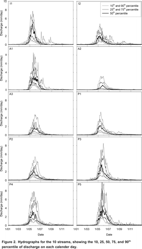
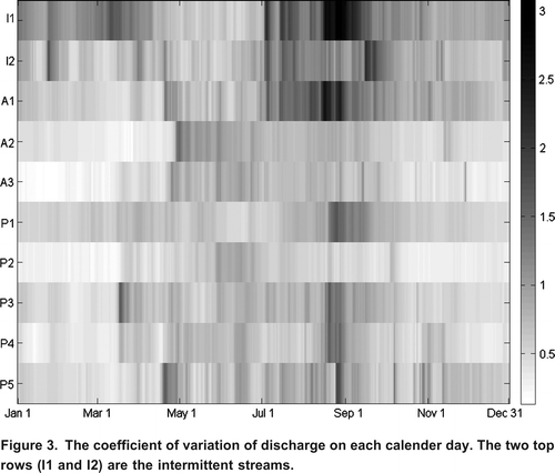
The coefficient of variation of discharge on each calendar day, also demonstrated that flow variability differed in timing and magnitude for the intermittent and perennial streams (). For the perennial streams and two of the almost-intermittent streams (A2 and A3), the coefficient of variation tended to be below 1.5. Furthermore, only short periods between April and October had relatively high coefficients of variation for discharge (). The intermittent streams and one almost-intermittent stream (A1), on the other hand, had much higher coefficients of variation that lasted for longer periods in late August and September ().
Figure 3. The coefficient of variation of discharge on each calender day. The two top rows (I1 and I2) are the intermittent streams.
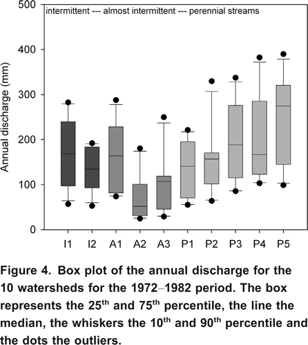
Mean annual discharge and the variation in annual discharge, however, were similar for the intermittent and perennial streams (). Mean annual discharge varied from 73 mm to 245 mm (mean and median 158.5 mm; = 50.1 mm). Mean annual discharge and mean annual precipitation were correlated (rs = 0.66, p = 0.044) but there was no statistically significant relation between mean annual precipitation and runoff ratios (p = 0.143) for the 10 watersheds.
Figure 4. Box plot of the annual discharge for the 10 watersheds for the 19721982 period. The box represents the 25th and 75th percentile, the line the median, the whiskers the 10th and 90th percentile and the dots the outliers.
Spring Freshet
The intermittent streams tended to have a slightly earlier median start of spring freshet compared to the perennial and almost-intermittent streams, although the earliest start date of the freshet did not differ between the intermittent and perennial streams (). The day of the year of the peak freshet and the median peak freshet, however, were similar for the perennial and intermittent streams ( and ). The median day of the year of the start of the freshet and the peak freshet occurred earlier for watersheds located further north and further west (). Not surprisingly, the median day of the year of the peak of the freshet was also correlated with the average and maximum elevation of the watershed (rs = 0.96 and 0.86, p = 105 and 0.001, respectively; ).
Figure 5. Box plot of the day of year of the start of the spring freshet (for explanation of the boxplots see ). DoY 70 represents March 11th and DoY 130 represents May 10th.
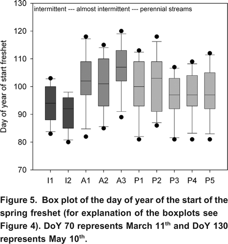
Table 3. Spearman rank correlation coefficients (rs) for the relations between the physical characteristics of the watersheds and the streamflow characteristics. Rock types include intrusive (Intrus.), metamorphic (Meta.), volcanic (Volc.) and sedimentary (Sed.). Values are only shown for correlations with p < 0.10. Values in italic represent correlations with p < 0.05, while values in bold represent correlations with p<0.01.
Summer Low Flows
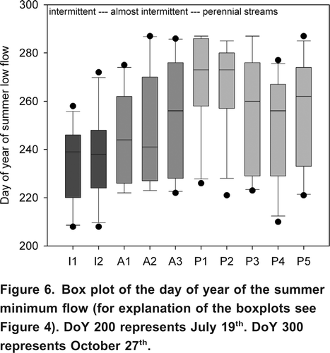
As expected, the intermittent streams and one almost-intermittent stream (A1) had considerably lower summer minimum flows compared to the perennial streams and the other almost-intermittent streams (A2 and A3) (). The intermittent streams were also characterized by an earlier summer minimum streamflow, although there was a large spread in the data ( and ). The median summer minimum flow was only statistically significantly correlated to the drainage density (rs = 0.71, p = 0.022) (). The median day of the year of the summer low flow was only correlated to the average slope (rs = 0.61, p = 0.061) and stream length (rs = 0.56, p = 0.092), with summer minimum flow occurring later for watersheds with steeper slopes ().
Figure 6. Box plot of the day of year of the summer minimum flow (for explanation of the boxplots see ). DoY 200 represents July 19th. DoY 300 represents October 27th.
Interestingly, the intermittent streams and almost-intermittent stream A1 had almost the same median discharge on March 15th and August 15th or a lower median discharge on August 15th than on March 15th, while for the perennial streams and the other almost-intermittent streams the median discharge was significantly higher on August 15th than on March 15th (). Median discharge on August 15th was not correlated to any of the physical watershed characteristics for which we had data. Median discharge on March 15th was positively correlated with drainage density (rs = 0.90, p = 0.001), average slope (rs = 0.64, p = 0.054) and the fraction covered by sedimentary bedrock (rs = 0.57, p = 0.083) (). Three of the four watersheds with the highest median March 15th discharge, are located in the Northern part of the Okanagan Basin and have areas of sedimentary bedrock ( and ). However, watershed P2, located in the western part of the Okanagan Basin, has no sedimentary bedrock and had the highest median March 15th discharge.
A comparison of master recession curves clearly illustrated that the master recession constant was lower for the intermittent streams and almost-intermittent stream A1 than for the other almost-intermittent streams and perennial streams (), indicating a faster decrease in streamflow and storage during the recession period for the intermittent streams and almost-intermittent stream A1 than the other streams. The master recession constant was correlated with drainage density (rs = 0.67, p = 0.039) and inversely correlated with the fraction of the watershed that consists of metamorphic bedrock (rs = 0.70, p = 0.025) (). Only the intermittent streams, almost-intermittent stream A1, and P5, which becomes intermittent downstream of the gauging station, are covered in part by metamorphic bedrock ().
Fall Peakflows
The intermittent streams had large variations in fall peakflows and tended to have a higher maximum fall discharge than the perennial and almost-intermittent streams ( and ). The combination of higher fall peakflows and lower summer low flows means that during some years the relative rise in streamflow was much larger for the intermittent streams than for the perennial streams. However, the minimum fall peakflow was also lower for the intermittent streams and almost-intermittent stream A1 than for the other streams ().
Figure 7. Box plot of fall peak flow (for an explanation of the boxplots see ).
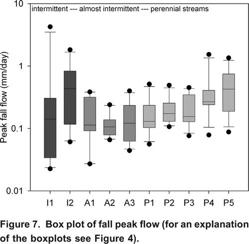
To further understand the significance of fall peakflows and possible regime differences, individual hydrographs were examined. This revealed that high fall peakflows between September 1st and November 1st did not occur every year at any of the streams but occurred more frequently for the intermittent streams than for the perennial streams. Furthermore, watersheds on the eastern side of the Okanagan Basin had higher fall peakflows than those on the drier west side. For example, in 1976 all watersheds with high fall peakflows were located in the east, although P4 and P3 in the northwest also had fairly high fall peakflows, while P2, A3 and A2 in the west had very low fall peakflows or no increases in streamflow in fall at all. Not only the intermittent streams, but also P1 had very high fall peak flows in 1976. This was also true for 1978, when most eastern streams had high fall peakflows and streams on the western side had low fall peakflows.
The median fall peakflow was inversely correlated to the area of the watershed covered by forest (rs = 0.68, p = 0.035) (). There was also a correlation between drainage density and median fall peakflow but the two watersheds with the highest median fall peak flows (I2 and P5) did not follow this trend. Therefore the relation between drainage density and median fall peakflow was not statistically significant (p = 0.349).
Flow Duration Curves
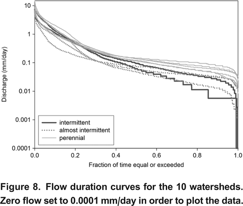
The slopes of the FDCs differed for the intermittent and perennial streams. A qualitative visual examination of the general shape of all ten FDCs indicates that the high discharges follow a similar frequency distribution, with the exception of A2. At the 20th percentile the almost-intermittent streams start to deviate from the general frequency pattern and the FDC slopes steepen through to the 60th percentile, at which point the slopes become similar again to the perennial streams. In contrast, the intermittent streams tend to have a fairly uniform slope, with the exception of the upper and lower reaches of the curve.
The FDCs of the intermittent streams were steeper at low to medium discharge compared to those of the perennial streams ( and ). FDCslope ranged between 4 and 5 for the intermittent streams and almost-intermittent stream A1, whereas for the perennial and remaining almost-intermittent streams it ranged from 1.9 to 3.3 (). These results compare well with the master recession results and also suggest that streamflow declined more rapidly during the summer at the intermittent stations and station A1 than at the other almost-intermittent stations and the perennial stations. FDCslope was correlated with the percentage of time with zero flow (rs = 0.67, p = 0.036). It was also correlated with longitude (rs = 0.74, p = 0.014), the fraction of metamorphic bedrock (rs = 0.68, p = 0.030), and inversely correlated to the fraction of intrusive bedrock (rs = 0.73, p = 0.017) (). Longitude and the fraction of the area covered with metamorphic bedrock (rs = 0.57, p = 0.083) and intrusive bedrock (rs = 0.69, p = 0.027) are also correlated.
Figure 8. Flow duration curves for the 10 watersheds. Zero flow set to 0.0001 mm/day in order to plot the data.
Cluster Analysis
Cluster analysis showed that based on the physical watershed characteristics, the ten watersheds can be divided into five groups (ab). The watersheds with the intermittent streams (I1 and I2) form one group and are thus distinct from the other watersheds. P5, which becomes intermittent below the station, forms itself a group. These two watershed groups are characterized by a low average slope and the smallest fraction of the watershed covered by forest. P1, the only watershed that consists predominantly of sedimentary bedrock (), also is distinct from the other groups. The almost-intermittent streams A2 and A3 form another group together with perennial stream P2. These watersheds are located on the west side of the Okanagan Basin and are for a large part composed of intrusive rock (; ). The final group consists of almost-intermittent stream A1 and perennial streams P1, P3, and P4. These watersheds have the lowest minimum elevations.
Figure 9. Results of the cluster analysis based on all physical characteristiscs (latitude, longitude, drainage area, drainage density, average and maximum slope, average, minimum, and maximum elevation, fraction covered by forest, fraction of intrusive bedrock, metamorphic bedrock, volcanic bedrock, and sedimentary bedrock) (a), based on only the topographic and location characteristics (latitude, longitude, drainage area and density, average and maximum slope, average, maximum, and minimum elevation) (b), and the main streamflow characteristics (mean annual flow, mean runoff ratio, median peak freshet, median summer low flow, median fall peak flow, median day of year of start of freshet, peak freshet, and summer low flow, median flow on March 15 and August 15, FDCslope, and the master recession constant) (c).
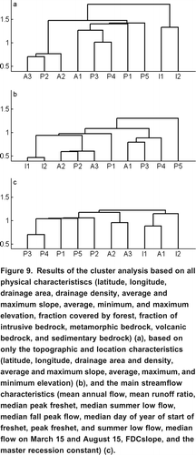
The cluster analysis based on the main hydrograph characteristics () showed that there are three types of hydrographs: those from the intermittent streams plus A1, from the other almost-intermittent streams A2 and A3, and from the perennial streams (c). Thus, even though the behavior of almost-intermittent streams A2 and A3 appeared similar to those if the perennial streams, the cluster analysis results suggest that they are distinct from the perennial streams, and distinct from the intermittent streams and A1.
Discussion
The five streamflow regime components of Poff and Ward (Citation1989) to characterize watersheds were used to assess the degree of similarity and dissimilarly between intermittent, almost-intermittent, and perennial streams in the Okanagan Basin. All ten studied watersheds are characterized by nival (snowmelt dominated) runoff regimes (). The streamflow hydrographs () are similar in shape: a steep rising limb to peak discharge in May, followed by a long recession. There are no obvious visual differences in the overall shape of the median hydrographs between the intermittent, almost-intermittent and perennial streams. This similarity in the hydrograph shape is not unexpected as all watersheds are affected by the same climatic regime. It is thus the subtleties of the hydrographs that indicate that there may be differences between intermittent, almost-intermittent and perennial streamflow regimes in the Okanagan Basin. Almost-intermittent stream A1 exhibited many streamflow characteristics that are similar to the intermittent streams but the cluster analysis results suggest that its physical characteristics are distinct from those of the two intermittent watersheds. The other two almost-intermittent streams had flow regimes that resembled the perennial streams, although cluster analysis has them separate.
Magnitude
Annual Discharge
There were no clear differences in either the mean or median annual discharge between the intermittent, almost-intermittent, and perennial streams ( and ). There were no differences in peak freshet between the intermittent, almost-intermittent, and perennial watersheds either, most likely because all watersheds experienced similar snow accumulation and snowmelt regimes.
Summer Low Flows
Not surprisingly, median summer low flows were significantly lower for the intermittent streams and almost-intermittent stream A1 than for the other almost-intermittent streams and the perennial streams. The average of the median summer minimum discharge for the intermittent streams and stream A1 was only 20% of the average of the median minimum summer discharge of all ten stations. Summer low flows are often determined by groundwater discharge into the stream and geomorphology (Smakhtin, Citation2001; Tague and Grant, Citation2004; Price et al., Citation2011). Although recession constants were high for all watersheds, they were lowest for the intermittent streams and the FDCs were steepest for the intermittent streams (), indicating that the intermittent streams likely have less groundwater inflow and/or had groundwater reservoirs that drained more quickly. However, field observations in England by Anderson and Burt (Citation1980) showed that at very low flows, discharge can be maintained by throughflow in the vadose zone, especially in watersheds with impermeable bedrock. For these situations they reported recession constants greater than 0.9 and yet found no evidence of actual groundwater contribution to streamflow.
The watersheds of the intermittent streams have the lowest slope and drainage density and may therefore have fewer points of interaction with regional groundwater flowpaths. The 2-dimensional modelling results of Welch et al. (Citation2012) show that bedrock groundwater discharge was less for the hillslope with the lower slope, except for the very low applied recharge case. This was attributed to the longer seepage face and shorter upslope recharge zone for the model with the lower slope. Other studies have shown that watersheds with low drainage densities are characterized by more bedrock groundwater flow. Onda et al. (Citation2006), for example, showed for watersheds in Japan that bedrock groundwater flow was dominant in un-weathered hard shale and argillite watersheds, whereas subsurface stormflow through the soil mantle was the dominant runoff generation mechanism in granite watersheds that were not as deeply dissected. Tague and Grant (Citation2004) showed that summer streamflow was higher and recessions were slower for watersheds with a higher percentage of High Cascade geology, dominated by low gradient basaltic and andesitic lava flows, cinders, pumice, and volcanic ash, that are characterized by low drainage densities (12 km/km2). Unfortunately, we have no information on the characteristics of the bedrock or the regional groundwater flowpaths in the Okanagan Basin and thus can not assess the effects of slope and drainage density on groundwater contributions to streamflow.
Winter low flows (e.g., March 15 flow) and summer low flows (e.g., August 15 flow) were similar for the intermittent streams and almost-intermittent stream A1, whereas low flows were significantly larger in summer than in winter for the perennial streams and the other two almost-intermittent streams. Like the results from the flow duration curves and the master recession curves, this also suggests that groundwater storage is depleted faster for the intermittent streams and almost-intermittent stream A1 than for the other streams.
March 15th flows were highest for watersheds with sedimentary bedrock that are located in the Northern part of the Okanagan Basin, have high drainage densities and low minimum elevations. Winter rainfall and rain-on-snow melt events at lower elevations may possibly contribute to the larger winter flows for these watersheds. However, winter temperatures were not higher than the average of the 10 watersheds, suggesting that differences in precipitation (rain vs snow) are small. It is thus likely that the high March 15th flows are at least in part related to differences in groundwater flow pathways, which is in line with the results of Onda et al. (Citation2006), who showed that bedrock groundwater flow was more important in watersheds underlain by shale than in watersheds underlain by granite. However, this is contrary to the results of Shimizu (1980, referenced in Tani et al., Citation2012) and Katsuyama (Citation2008), who showed that watersheds underlain by sedimentary bedrock had a more flashy runoff response and less sustained baseflow than watersheds underlain by igneous bedrock.
Fall Peakflows
Fall peakflows were most variable for the intermittent streams. The peaks were low for the intermittent streams in some years, but in years with high fall precipitation, they were highest for the intermittent streams, resulting in a much larger variability in fall peakflows for the intermittent streams than the perennial streams (). The effects of localized large storms is larger in small watersheds than in large watersheds. However, drainage area does not explain the differences between median fall peak flow for the watersheds studied here. Watershed I2 is similar in size to A2 and P2, and the drainage area of A1 is similar to that of the other perennial watersheds. There was no significant correlation between drainage area and median fall peakflow (p = 0.973) either and high fall peakflows occurred in several watersheds, suggesting that it was not likely due to localized precipitation events. Furthermore, Toews et al. (Citation2009) showed that local precipitation in the Okanagan mainly occurs between April and September and that recharge from these localized precipitation events is insignificant.
The higher fall peakflows during the years with high fall rainfall could be caused by a lower soil moisture and groundwater storage capacity for the watersheds with intermittent streams or faster and more direct flow pathways, which would also cause them to have lower summer low flows and an earlier start of the freshet. Median fall peakflow and median day of the start of the freshet (rs = 0.62, p = 0.056) were correlated. However, we currently do not have any information on the storage and hydraulic properties of the different watersheds and thus can not confirm if the watersheds of the intermittent streams have a lower storage capacity and/or higher hydraulic conductivity soils with shorter and faster flow pathways. Watersheds with higher drainage densities and shallower flowpaths generally have a flashier response than watersheds with a lower drainage density (Tague and Grant, Citation2004; Onda et al., Citation2006). However, in this study the watersheds of the intermittent streams that had the highest fall peakflows, have the lowest slopes and lowest drainage densities.
The median fall peakflow was highest for the watersheds with the lowest forest cover (). Reduced forest cover leads to lower interception and transpiration losses. As a result, soils are wetter and respond more quickly to fall recharge events. Paired watershed experiments have shown that streamflow increases after logging are frequently largest in the fall (Moore and Wondzell, Citation2005) but because the watersheds with relatively low forest cover still had more than 50% forest cover and in years without high fall precipitation had the lowest maximum fall discharge, it is not likely that this is the main cause for the differences in fall peakflows.
Frequency and Duration
The streamflow frequency regimes for the ten watersheds indicate there are differences and similarities between intermittent and perennial streams. This was expected as the shape of the FDC is partially defined by climate and watershed characteristics (Searcy, Citation1959; Vogel and Fennessey, Citation1995), which are similar throughout the Okanagan Basin. The frequency and duration of zero flow for the intermittent streams was minimal (). The intermittent periods occurred during the late summer (AugustSeptember) and persisted for a maximum of ten consecutive days. Zero flow was recorded at I1 in two of the eleven years (1973 and 1978) and at I2 during only one year (1979), although discharge was frequently below 0.01 mm/day for a week or more during August or September for I1, I2, and A1. Discharge was rarely, if ever, below 0.01 mm/day for the other almost-intermittent and perennial streams. Periods of zero flow are more frequent for the truly intermittent streams, which are not gauged continuously and are therefore not part of this analysis.
The FDCs were steeper at low and medium discharge for the intermittent streams compared to the perennial streams ( and ). Had there been data for truly intermittent streams with longer periods of zero flow, the shape of the lower end of the FDCs would have been even steeper and cut off earlier. The conceptual framework for reconstructing FDCs suggests evapotranspiration (ET) and soil moisture storage capacity control the slope of the FDC at low discharges, while high ET from the saturated surface and/or low soil storage capacity steepen the FDC (Yokoo and Sivapalan, Citation2011). This suggests that evapotranspiration rates are higher in the watersheds of the intermittent streams and/or that these watersheds have a lower storage capacity than the watersheds with the perennial streams.
The slope between the 33rd and 66th percentiles of the FDC ranged between 4 and 5 for the intermittent streams and almost-intermittent stream A1, whereas for the perennial and remaining almost-intermittent streams the slope ranged from 1.9 to 3.3 (). The slope between the 33rd and 66th percentiles of the FDC is controlled predominantly by groundwater or subsurface flow. Steeper slopes suggest less groundwater discharge to the stream and more permeable soils (Searcy, Citation1959; Vogel and Fennessey, Citation1995; Yokoo and Sivapalan, Citation2011). These results indicate a larger groundwater influence in perennial streams compared to the intermittent streams and are consistent with the master recession results. Field research is required to quantify and validate these findings.
Discharge above the 10th percentile were all within a factor of two, with the exception of A2 which had a significantly lower discharge at the upper end of the FDC. The dominant control on the upper portion of a FDC is precipitation (Yokoo and Sivapalan, Citation2011). The similarity in shape of the upper portions of the FDCs is thus likely explained by the relatively similar input of melt water during freshet. There is no obvious explanation for the low peak freshet in watershed A2.
Timing
The freshet tended to start slightly earlier for the intermittent streams, although the earliest day of the year of the start of the freshet in the 11 years of record was similar for the intermittent, almost-intermittent and perennial streams (). An earlier start of the freshet can often be explained by lower elevations and or more southerly aspects causing an earlier onset of snowmelt, but the mean elevation of the watersheds with the intermittent streams was neither the highest nor the lowest. Watershed I1 has the second highest minimum elevation, which would normally be reason for a later start or peak freshet; neither watershed I1 nor I2 had the lowest maximum elevation. In fact, there was no correlation between the median day of year of the start of spring freshet and elevation (p = 0.723, 0.208, and 0.287 for minimum, average, and maximum elevation, respectively). The median day of peak freshet was highly correlated with the average and maximum elevation of the watershed ().
The correlation between the median day of the year of the start of the freshet and the area of intrusive and volcanic bedrock () suggests that perhaps geomorphological aspects of these watersheds or soil properties influence the start of the spring freshet. However, we currently do not have enough information on these watersheds to investigate this in more detail. As the median day of the year of the start of the freshet occurred only slightly earlier for the intermittent streams (), it could also be related to the hydraulic conductivity of the soils, the storage capacity, and flowpath-lengths through the watershed. Perhaps melt is initiated at all watersheds around the same time but shallow soils or an impermeable layer beneath the surface causes water to flow to the stream faster in the watersheds with intermittent streamflow. Shallower flowpaths or more conductive soils could also explain the larger increases in streams in fall for the intermittent streams.
Rate of Change
The intermittent streams had much higher fall peakflows during years with high fall precipitation and thus a much higher rate of change in streamflow in fall during those years than the other streams. However, in years without high precipitation in the fall, maximum fall discharge was very low and the rate of change in fall was thus very low. This results in a higher variability () and a much lower predictability in streamflow in fall for the intermittent streams than the perennial streams. This higher rate of change and lower predictability in fall peakflow could have large ecological consequences (Poff et al., Citation1997).
Leith and Whitfield (Citation1998) examined the streamflow records of six streams in south-central BC for hydrological changes that may be caused by climate change. They found that the temporal pattern of streamflow had changed and that the changes were consistent with those expected from climate change. The studied streams exhibited an earlier freshet, lower late summer flows, and earlier and higher fall flows during the 19841995 period than during the 19711983 period. These results are attributed to higher temperatures and thus earlier melt in spring causing a longer dry season, and precipitation in fall being rain instead of snow. These changes in streamflow characteristics correspond with the subtle differences between the intermittent and perennial streams in this study. The intermittent streams and almost-intermittent stream A1 had a slightly earlier median day of the year of the start of the freshet, a lower summer minimum streamflow, and higher fall peak flows during some years than the perennial streams. This thus suggests that these streams may be most vulnerable to changes in climate. Because Leith and Whitfield (Citation1998) showed that these changes occurred after 1983 and for this study only data until 1982 was used, it is important to also study current differences between intermittent and perennial streams and whether some of the former perennial streams now have streamflow regimes that resemble those of the intermittent streams or if the differences between the intermittent and perennial streamflow regimes have become more pronounced.
The recession constants were lowest for the intermittent streams and the FDCs were steepest for the intermittent streams (), indicating that in addition to the larger rise in streamflow in fall in some years, streamflow in summer also decreased faster for the intermittent streams. This is likely because of less groundwater inflow and/or groundwater reservoirs that drained more quickly, resulting in similar or lower streamflow on August 15th than March 15th for the intermittent streams, while streamflow was significantly higher on August 15th than on March 15th for the perennial streams.
Conclusion
This study focused on streamflow regimes of intermittent and perennial streams in the Okanagan Basin. The majority of the analyses showed only subtle differences between intermittent and perennial streams. Most previous studies that have compared runoff regimes have been conducted over areas that are much larger than the Okanagan Basin, where climate is more variable and has a larger influence on the differences in the flow regimes. The differences in the flow regimes and physical characteristics in this study may also only be subtle because our analyses included only two intermittent streams. Differences between intermittent and perennial streams may become clearer (or disappear) if more streams were studied. It is likely that the differences in the flow regimes would be larger if truly intermittent streams in the Okanagan Basin that run dry every single year were included. However, there is currently no year-round data for more than 2 years for these streams. We thus highly recommend continuous monitoring of intermittent streams in order to characterize their behaviour and understand how their flow regimes are different from perennial streams.
Due to the small number of intermittent streams, no strong conclusions about the differences in flow regimes between intermittent and perennial streams can be made but the results suggest that some of their characteristics, in addition to the absolute minimum flow, may be different. The intermittent streams tended to exhibit a slightly earlier start of the spring freshet and higher fall peak flows during years with high precipitation in fall. As a result, they exhibited higher variability in streamflow in late summer and fall than the perennial streams. The intermittent streams also had the steepest flow duration curves and the lowest master recession constants. The difference between the median flow on August 15 and March 15 was also much smaller for the intermittent streams than the perennial streams. These subtle differences in the streamflow regime characteristics, in addition to the lower minimum summer flows, may have important implications for stream ecology and point to different runoff generation mechanisms and residence times for water in the intermittent and perennial watersheds. The slightly earlier start of the freshet, faster decline in streamflow in summer, and faster and larger response to fall precipitation events suggest that perhaps flow pathways are shorter for the intermittent watersheds. The steeper flow duration curves and lower master recession constants suggest that there is less groundwater contribution to the intermittent streams and storage is depleted faster and/or is smaller. These hypotheses need to be confirmed by field data and/or modelling studies.
Acknowledgements
We would like to thank Judy Kwan (Environment Canada) for sharing the watershed shape files with us, John Ng (Simon Fraser University) for help with and obtaining the watershed physical characteristics and Mathieu Beaulieu (Environment Canada) for the abstract translation. This work was supported by an NSERC Discovery Grant.
Related Research Data
References
- Allan, J. D. 1995. Physical factors of importance for biota. Chap. 3 in Stream ecology: Structure and function of running waters, ed. Chapman & Hall, 4546. Dordrecht, The Netherlands: Kluwer Academic Publishers.
- Anderson , M. G. and Burt , T. P. 1980 . Interpretation of recession flow . Journal of Hydrology , 46 : 89 – 101 .
- Arthington , A. H. and Pusey , B. J. 2003 . Flow restoration and protection in Australian rivers . River Research and Applications , 19 : 377 – 395 .
- Bernhardt , E. S. , Palmer , M. A. , Allan , J. D. , Alexander , G. , Barnas , K. , Brooks , S. and Carr , J. 2005 . Synthesizing U.S. river restoration efforts . Science , 308 ( 18 ) : 636 – 637 .
- Bowen , P. A. , Bogdanoff , C. P. , Estergaard , B. F. , Marsh , S. G. , Usher , K. B. , Smith , C. A. S. and Frank , G. 2005 . Geology and wine 10: Use of geographic information system technology to assess viticulture performance in the Okanagan and Similkameen valleys, British Columbia . Geoscience Canada , 32 ( 4 ) : 161 – 176 .
- British Columbia Integrated Land Management Bureau. 2011. Land Resource Data Warehouse. http://www.lrdw.ca (accessed July 2011).http://www.lrdw.ca
- Bunn , S. E. and Arthington , A. H. 2002 . Basic principles and ecological consequences of altered flow regimes for aquatic biodiversity . Environmental Management , 30 ( 4 ) : 492 – 507 .
- Buttle , J. M. , Boon , S. , Peters , D. L. , Spence , C. , van Meerveld , H. J. and Whitfield , P. H. 2012 . An overview of temporary stream hydrology in Canada . Canadian Water Resources Journal , 37 ( 3 )
- Chang , F. , Tsai , W. , Wu , T. , Chen , H. and Herricks , E. E. 2011 . Identifying natural flow regimes using fish communities . Journal of Hydrology , 409 ( 12 ) : 328 – 336 .
- Daly , C. , Gibson , W. P. , Taylor , G. H. , Johnson , G. L. and Pasteris , P. 2002 . A knowledge-based approach to the statistical mapping of climate . Climate Research , 22 : 99 – 113 .
- Datry , T. and Larned , S. T. 2008 . River flow controls ecological processes and invertebrate assemblages in subsurface flowpaths of an ephemeral river reach . Canadian Journal of Fisheries & Aquatic Sciences , 65 : 1532 – 1544 .
- Eaton, B. C., and R. D. Moore. 2010. Regional hydrology. Chap. 4 in Compendium of forest hydrology and geomorphology in British Columbia. B.C. Min. For. Range, ed. R. G. Pike, T. E. Redding, R. D. Moore, R. D. Winkler, and K. D. Bladon, 85110. Victoria, British Columbia: Sci. Prog., and FORREX Forum for Research and Extension in Natural Resources, Kamloops, B.C. Land Manag. Handb. 66. B.C. Ministry of Forests and Range Research Branch, Victoria, B.C. and Forum for Research and Extension in the Natural Resources, Kamloops. doi:10.1007/BF02376895.
- Environment Canada. 2011a. National climate data and information archive climate normals in British Columbia. http://www.climate.weatheroffice.gc.ca/climate_normals/stnselect_e.html?pageid=1&lang=e&province=BC&provBut=Search (accessed April 2011).http://www.climate.weatheroffice.gc.ca/climate_normals/stnselect_e.html?pageid=1&lang=e&province=BC&provBut=Search
- Environment Canada. 2011b. Hydrometric data search. http://www.wsc.ec.gc.ca/applications/H2O/index-eng.cfm (accessed January 2011).http://www.wsc.ec.gc.ca/applications/H2O/index-eng.cfm
- Government of British Columbia Ministry of Environment. 2011. Snow survey data. http://a100.gov.bc.ca/pub/mss/stationlist.do (accessed April 2011).http://a100.gov.bc.ca/pub/mss/stationlist.do
- Government of British Columbia Ministry of Transport. 2011. Weather data. https://pub-apps.th.gov.bc.ca/saw-paws/weatherstation (accessed April 2011).https://pub-apps.th.gov.bc.ca/saw-paws/weatherstation
- Greet , J. , Webb , J. A. and Cousens , R. D. 2011 . The importance of seasonal flow timing for riparian vegetation dynamics: A systematic review using causal criteria analysis . Freshwater Biology , 56 ( 7 ) : 1231 – 1274 .
- Harma , K. , Johnson , M. and Cohen , S. 2011 . Future water supply and demand in the Okanagan Basin, British Columbia: A scenario-based analysis of multiple, interacting stressors . Water Resources Management , 26 ( 3 ) : 667 – 689 .
- Hart , D. D. and Finelli , C. M. 1999 . Physical-biological coupling in streams: The pervasive effects of flow on benthic organisms . Annual Review of Ecology and Systematics , 30 : 363 – 395 .
- Hauer , F. R. and Lorang , M. S. 2004 . River regulation, decline of ecological resources, and potential for restoration in a semi-arid lands river in the western USA . Aquatic Sciences , 66 ( 4 ) : 388 – 401 .
- Heinrichs , M. L. , Hebda , R. J. and Walker , I. R. 2001 . Holocene vegetation and natural disturbance in the Engelmann Spruce Subalpine Fir biogeoclimatic zone at Mount Kobau, British Columbia . Canadian Journal of Forest Research , 31 ( 12 ) : 2183 – 2199 .
- Junk , W. , Bayley , P. and Sparks , R. E. 1989 . The flood pulse concept in river-floodplain systems . Canadian Journal of Fisheries and Aquatic Sciences , 106 : 110 – 127 .
- Katsuyama , M. 2008 . Comparison of rainfall-runoff characteristics in forested catchments underlain by granitic and sedimentary rock with various forest age . Hydrological Research Letters , 2 : 14
- Kennard , M. J. , Pusey , B. J. , Olden , J. D. , Mackay , S. J. , Stein , J. L. and Marsh , N. 2010 . Classification of natural flow regimes in Australia to support environmental flow management . Freshwater Biology , 55 ( 1 ) : 171 – 193 .
- King , J. and Louw , D. 1998 . Instream flow assessments for regulated rivers in South Africa using the Building Block Methodology . Aquatic Ecosystem Health & Management , 1 ( 2 ) : 109 – 124 .
- LeBoutillier , D. W. and Waylen , P. R. 1993 . Regional variations in flow-duration curves for rivers in British Columbia, Canada . Physical Geography , 14 ( 4 ) : 359 – 378 .
- Leith , R. M. M. and Whitfield , P. H. 1998 . Evidence of climate change effects on the hydrology of streams in south-central British Columbia . Canadian Water Resources Journal , 23 ( 3 ) : 219 – 230 .
- Lloyd, N., G. Quinn, M. Thoms, A. H. Arthington, P. Humphries, and K. Walker. 2003. Does flow modification cause geomorphological and ecological response in rivers? A literature review from an Australian perspective: Technical report 1/2004. CRC for Freshwater Ecology. ISBN 0-9751642-02.
- Merritt , W. S. , Alila , Y. , Barton , M. , Taylor , B. , Cohen , S. and Neilsen , D. 2006 . Hydrologic response to scenarios of climate change in sub watersheds of the Okanagan basin, British Columbia . Journal of Hydrology , 326 : 79 – 108 .
- Moore , R. D. , Trubilowicz , J. W. and Buttle , J. M. 2011 . Prediction of streamflow regime and annual runoff for ungauged basins using a distributed monthly water balance model . Journal of the American Water Resources Association ,
- Moore , R. D. and Wondzell , S. M. 2005 . Physical hydrology and the effects of forest harvesting in the Pacific Northwest: A review . Journal of the American Water Resources Association , 41 : 763 – 784 .
- Neilsen , D. , Smith , C. A. S. , Frank , G. , Koch , W. , Alila , Y. , Merritt , W. S. , Taylor , W. G. , Barton , M. , Hall , J. W. and Cohen , S. J. 2006 . Potential impacts of climate change on water availability for crops in the Okanagan Basin, British Columbia . Canadian Journal of Soil Science , 86 ( 5 ) : 921 – 936 .
- Nilsson , C. and Svedmark , M. 2002 . Basic principles and ecological consequences of changing water regimes: Riparian plant communities . Environmental Management , 30 ( 4 ) : 468 – 480 .
- Onda , Y. , Tsujimura , M. , Fujihara , J.-i. and Ito , J. 2006 . Runoff generation mechanisms in high-relief mountainous watersheds with different underlying geology . Journal of Hydrology , 331 ( 34 ) : 659 – 673 .
- Okanagan Basin Water Board. 2011. http://www.obwb.ca/supply_demand/ (accessed December 2011).http://www.obwb.ca/supply_demand/
- Palmer , M. , Bernhardt , E. , Chornesky , E. , Collins , S. , Dobson , A. , Duke , C. , Gold , B. , Jacobson , R. , Kingsland , S. , Kranz , R. , Mappin , M. , Martinez , M. L. , Micheli , F. , Morse , J. , Pace , M. , Pascual , M. , Palumbi , S. , Reichman , O. J. , Simons , A. , Townsend , A. and Turner , M. 2004 . Ecology for a crowded planet . Science , 304 : 1251 – 1252 . May
- Poff , N. L. and Ward , J. V. 1989 . Implications of streamflow variability and predictability for lotic community structure: A regional analysis of streamflow . Canadian Journal of Fisheries and Aquatic Sciences , : 1805 – 1818 .
- Poff , N. L. and Zimmerman , J. K. H. 2010 . Ecological responses to altered flow regimes: A literature review to inform the science and management of environmental flows . Freshwater Biology , 55 ( 1 ) : 194 – 205 .
- Poff , N. L. , Allan , J. D. , Bain , M. B. , Karr , J. R. , Prestegaard , K. L. , Richter , B. D. , Sparks , R. E. and Stromberg , J. C. 1997 . The natural flow regime . BioScience , 47 ( 11 ) : 769 – 784 .
- Poff , N. L. , Richter , B. D. , Arthington , A. H. , Bunn , S. E. , Naiman , R. J. , Kendy , E. and Acreman , M. 2009 . The ecological limits of hydrologic alteration (ELOHA): A new framework for developing regional environmental flow standards . Freshwater Biology , 55 ( 1 ) : 147 – 170 .
- Power , M. E. , Sun , A. , Parker , G. , Dietrich , W. E. , Timothy , J. and Wootton , J. T. 1995 . Hydraulic food-chain models . BioScience , 45 ( 3 ) : 159 – 167 .
- Price , K. , Jackson , C. R. , Parker , A. J. , Reitan , T. , Dowd , J. and Cyterski , M. 2011 . Effects of watershed land use and geomorphology on stream low flows during severe drought conditions in the southern Blue Ridge Mountains, Georgia and North Carolina, United States . Water Resources Research , 47 : W02516
- Reece , P. F. and Richardson , J. S. 1995 . Benthic macroinvertebrate assemblages of coastal and continental streams and large rivers of southwestern British Columbia, Canada . Hydrobiologia , 439 : 77 – 89 .
- Resh , V. H. , Brown , A. V. , Covich , A. P. , Gurtz , M. E. , Hiram , W. , Minshall , G. W. , Reice , S. R. , Sheldon , A. L. , Wallace , J. B. and Wissmar , R. C. 1988 . The role of disturbance in stream ecology . Journal of the North American Benthological Society , 7 ( 4 ) : 433 – 455 .
- Richter , B. D. , Baumgartner , J. V. , Powell , J. and Braun , D. P. 1996 . A method for assessing hydrologic alteration within ecosystems . Conservation Biology , 10 ( 4 ) : 1163 – 1174 .
- Richter , B. D. , Baumgartner , J. , Wigington , R. and Braun , D. 1997 . How much water does a river need? . Freshwater Biology , 37 : 231 – 249 .
- Richter , B. D. , Warner , A. T. , Meyer , J. L. and Lutz , K. 2006 . A collaborative and adaptive process for developing environmental flow recommendations . River Research and Applications , 22 ( 3 ) : 297 – 318 .
- Report 984148.
- Sanborn , S. C. and Bledsoe , B. P. 2006 . Predicting streamflow regime metrics for ungauged streams in Colorado, Washington, and Oregon . Journal of Hydrology , 325 : 241 – 261 .
- Sauquet , E. and Catalogne , C. 2011 . Comparison of catchment grouping methods for flow duration curve estimation at ungauged sites in France . Hydrology and Earth System Sciences , 15 ( 8 ) : 2421 – 2435 .
- Sawicz , K. , Wagener , T. , Sivapalan , M. , Troch , P. and Carrillo , G. 2011 . Catchment classification: Empirical analysis of hydrologic similarity based on catchment function in the eastern USA . Hydrology and Earth System Sciences , 15 ( 9 ) : 2895 – 2911 .
- Water Supply Paper 1542A
- Smakhtin , V. 2001 . Low flow hydrology: A review . Journal of Hydrology , 240 : 147 – 186 .
- Stromberg , J. C. 2001 . Restoration of riparian vegetation in the south-western United States: Importance of flow regimes and fluvial dynamism . Journal of Arid Environments , 49 : 17 – 34 .
- Tague , C. and Grant , G. E. 2004 . A geological framework for interpreting the low-flow regimes of cascade streams, Willamette River Basin, Oregon . Water Resources Research , 40 ( 4 ) : 1 – 9 .
- Tallaksen , L. M. 1995 . A review of baseflow recession analysis . Journal of Hydrology , 165 : 349 – 370 .
- Tani , M. , Fujimoto , M. , Katsuyama , M. , Kojima , N. , Hosoda , I. , Kosugi , K.-i. , Kosugi , Y. and Nakamura , S. 2012 . Predicting the dependencies of rainfall-runoff responses on human forest disturbances with soil loss based on the runoff mechanisms in granite and sedimentary rock mountains . Hydrological Processes , 26 ( 6 ) : 809 – 826 .
- Toews , M. W. , Allen , D. M. and Whitfield , P. H. 2009 . Recharge sensitivity to local and regional precipitation in semiarid midlatitude regions . Water Resources Research , 45 ( 6 ) : 1 – 10 .
- University of British Columbia. 2011. ClimateWNA v4.60 program to generate climate normals for the Okanagan. http://www.genetics.forestry.ubc.ca/cfcg/ClimateWNA/ ClimateWNA.html (accessed August 2011).http://www.genetics.forestry.ubc.ca/cfcg/ClimateWNA/ ClimateWNA.html
- United States Geologic Survey. 2011. Groundwater information. RECESS documentation and computer program for analysis of streamflow and recession. http://water.usgs.gov/ogw/recess/ (accessed September 2011).http://water.usgs.gov/ogw/recess/
- Viola , F. , Noto , L. V. , Cannarozzo , M. and La Loggia , G. 2011 . Regional flow duration curves for ungauged sites in Sicily . Hydrology and Earth System Sciences , 15 ( 1 ) : 323 – 331 .
- Vogel , R. M. and Fennessey , N. M. 1995 . Flow duration curves II: A review of applications in water resources planning . Journal of the American Water Resources Association , 31 ( 6 ) : 1029 – 1039 .
- Walker , K. F. , Sheldon , F. and Puckridge , J. T. 1995 . A perspective on dryland river ecosystems . Regulated Rivers: Research & Management , 11 ( 1 ) : 85 – 104 .
- Wang , T. , Hamann , A. , Spittlehouse , D. and Murdock , T. N. 2012 . ClimateWNA-High-resolution spatial climate data for western North America . Journal of Applied Meteorology and Climatology , 61 : 16 – 29 .
- Wassenaar , L. I. , Athanasopoulos , P. and Hendry , M. J. 2011 . Isotope hydrology of precipitation, surface and ground waters in the Okanagan Valley, British Columbia, Canada . Journal of Hydrology , 411 ( 12 ) : 37 – 48 .
- Welch , L. , Allen , D. M. and van Meerveld , H. J. 2012 . Topographic influences on deep groundwater contributions to baseflow and the potential for intermittency of mountain headwater streams . 37 ( 3 )
- Yadav , M. , Wagener , T. and Gupta , H. 2007 . Regionalization of constraints on expected watershed response . Advances in Water Resources , 30 : 1756 – 1774 .
- Yokoo , Y. and Sivapalan , M. 2011 . Towards reconstruction of the flow duration curve: Development of a conceptual framework with a physical basis . Hydrology and Earth System Sciences , 15 ( 9 ) : 2805 – 2819 .
- Zhang , Z. , Wagener , T. , Reed , P. and Bhushan , R. 2008 . Reducing uncertainty in predictions in ungauged basins by combining hydrologic indices regionalization and multi objective optimization . Water Resources Research , 44 : W00B04