Abstract
On-site systems are successfully used across Ontario and Canada in rural areas to treat and disperse wastewater in areas without access to centralized sewer facilities. Ontario has detailed technical guidelines for the design and installation of on-site systems to help safeguard against contamination to public health and the environment. However, since on-site systems are managed by private users, there are significant risks to either surface and groundwater resources when the systems malfunction or are improperly operated and maintained. This research assesses and models these risks on a regional basis utilizing a GIS-based assessment tool. The developed risk assessment model uses nine pertinent parameters to account for contaminant loading and pathways, and system characteristics. Risk parameters included soil type, slope, lot size, surface water proximity, floodplain, groundwater intrinsic susceptibility, recharge areas and water supply proximity. When applied to Huron-Kinloss Township in Ontario, at-risk areas were successfully determined by the model and then confirmed and validated by local experts. Soil type, groundwater intrinsic susceptibility and system age were the greatest contributors to the overall risk for this area. The GIS-based model is useful for decision-makers in identifying at-risk areas for targeted management strategies such as prioritized re-inspection programs.
Les fosses septiques sont utilises avec succs partout en Ontario et au Canada dans les zones rurales afin de traiter et de disperser les eaux uses dans les rgions qui ne disposent pas d'un accs des installations ou des canalisations dgout centralises. L'Ontario a adopt des directives techniques dtailles pour la conception et la mise en place d'installations septiques afin de contrer la contamination de l'environnement et de protger ainsi la sant publique. Cependant, tant donn que les installations septiques sont gres par des utilisateurs privs, des risques considrables psent sur les ressources en eau de surface ou souterraine lorsque les installations fonctionnent mal ou ne sont pas exploites et entretenues de faon approprie. La prsente recherche vise valuer et modliser ces risques une chelle rgionale l'aide d'un outil dvaluation SIG. Le modle dvaluation du risque qui a t labor fait appel neuf paramtres pertinents pour reprsenter la charge de contaminants et leur cheminement, ainsi que les caractristiques du systme. Les paramtres de risque englobaient le type de sol, la pente, les dimensions du terrain, la proximit des eaux de surface, le primtre d'inondation, la susceptibilit intrinsque des eaux souterraines, les zones d'alimentation et la proximit des rserves ou des sources d'eau. Lorsque le modle a t appliqu au canton de Huron-Kinloss en Ontario, il a permis de dterminer avec succs les zones risque, et celles-ci ont ensuite t confirmes et valides par des experts locaux. Le type de sol, la susceptibilit intrinsque des eaux souterraines et lge de l'installation ont t les facteurs ayant contribu le plus au risque global pour cette rgion. Le modle SIG est utile aux dcideurs en ce qu'il leur permet de cerner les zones risque en vue de l'adoption de stratgies de gestion cibles comme les programmes de rinspection des fosses septiques dans les zones prioritaires.
Introduction
Increasing emphasis is being placed on on-site wastewater systems as reliable and proven treatment systems as part of the permanent rural infrastructure. These systems provide a means of treating and dispersing wastewater back to the environment in a manner that protects both public health and the environment (Carroll et al., Citation2006). This realization has helped to develop more stringent treatment criteria and standards for on-site systems, the advancement of new technologies to meet these environmental sensitivities (Siegrist et al., Citation2000) and also the need for re-inspection and education programs for owners, operators, and installers of on-site systems.
In Ontario and elsewhere, even with rigorous technical guidelines for the design and installation of on-site systems, it is generally acknowledged that these systems can pose significant risks to both surface and groundwater resources. The ability of on-site systems to adequately treat domestic wastewater and protect both human and environmental health depends on a number of factors including soil and geologic conditions, wastewater loading regimes and proper operation and maintenance. Studies have shown that the failures of soil absorption systems can be a major source of contamination within rural watersheds (Jamieson et al., Citation2003). In addition bacteria and viruses present in domestic wastewater are known to cause the majority of waterborne diseases (Shadford et al., Citation1997). Thus, extensive groundwater contamination may result from systems in areas that are characterized as having groundwater tables near the ground surface (Scandura and Sobsey, Citation1997).
Society relies on surface and groundwater as sources of drinking water. On-site system performance can directly influence both surface and ground water quality. It is critical to protect water quality, especially within rural areas, where residents generally rely on little or no treatment for their drinking water. Systems installed in challenging conditions can result in the contamination of surface water and ground water. Inappropriate operation and poor maintenance of on-site systems can also lead to malfunctioning or degraded systems which increase the risk of contamination. The associated health risks, environmental effects and costs to tourist and recreational industries, taxpayers, and property owners can be substantial.
The same on-site system site evaluation and design criteria have generally been applied to sites located adjacent to environmentally sensitive areas as have been applied to sites located in areas with less significant public health and environmental concerns. There is a need to systematically identify areas that present higher risks for contamination to ground and surface waters so that approaches can be taken to strategically safeguard public health and the environment. Identification of areas that are at high risk for contamination from on-site systems can be used for watershed planning policies and practices, enhancing the enforcement of current regulations and legislation, and also the development of re-inspection or maintenance and educational programs aimed at improving awareness of operational and maintenance issues necessary for on-site systems.
This paper reports on the development of a GIS-based risk assessment tool for on-site systems with a focus on identifying areas where on-site systems present higher risks to public health and the environment. Outcomes of this paper will be the application and development of a GIS-based risk assessment model which takes into consideration locally available information within Ontario and also many other jurisdictions. This will allow for the collective assessment of numerous on-site systems within regulatory regions and allow the management and mitigation of the identified risks through prioritized management strategies such as targeted re-inspection programs.
Background
On-site systems are used to treat human waste extensively in rural areas which do not rely on centralized public sewerage facilities (United States Environmental Protection Agency (USEPA), Citation2002). On-site systems are complex in that they rely on physical, chemical, and biological processes to transform and treat chemical and biological constituents of waste (USEPA, Citation2002). Systems may include an advanced treatment unit, before the soil absorption system, that is designed to enhance removal of certain constituents (i.e. nitrates, phosphorus, and pathogens). Soil treatment units or leaching fields for conventional systems, which make up a large majority of on-site systems in current use, commonly account for the majority of the removal through natural attenuation processes (USEPA, Citation2002).
Numerous cases of environmental and public health-related contamination coming from on-site systems are well documented in Canada, the United States and Australia. Groundwater contamination may be the result of aging or failing systems that have utilized out-of-date standards. One example of this was a large outbreak of pathogen contaminated groundwater at a restaurant in the Yukon Territory of Canada. A viral gastroenteritis outbreak affected over 54 patrons and restaurant staff and six were hospitalized. The outbreak was clearly linked to well water contamination by a wood-lined septic tank located 15 metres away from the well, through dye tracing (Beller et al., Citation1997). Older systems, such as this case in the Yukon, are usually constructed of material (i.e. wood, steel) that can corrode and create a hazard for both public safety and contamination of ground and surface water. Ground and surface water contamination can also come from other factors such as higher on-site system density associated with smaller lot sizes (Borchardt et al., Citation2003; Yates, Citation1985).
Although there have been numerous studies relating groundwater contamination to failing or poorly maintained systems, there is also the issue of on-site systems installed in challenging or non-ideal situations. In north-eastern Wisconsin, patrons and employees of a new restaurant were affected by acute gastroenteritis (Borchardt et al., Citation2010). An epidemiological analysis indicated that drinking the well water of the restaurant was associated with the illness. To confirm the source of contamination, several dye injection tracer tests at two points in the on-site system showed that effluent was traveling from the septic tank and soil absorption system to the well within two weeks. The restaurant on-site system and well (85-m deep, in a fractured dolomite aquifer) both conformed to state codes (Borchardt et al., Citation2010). This demonstrates that in highly vulnerable hydrogeological settings, compliance with regulations may not provide adequate protection from pathogens (Borchardt et al., Citation2010). Water supply wells located in fractured rock and karst formations are particularly vulnerable to contamination from surface sources because groundwater velocities in such media can be rapid with minimal contaminant attenuation.
Borchardt et al. (2010) highlight the need to take many risk factors into account, rather than just horizontal and vertical setback distances. However the quantification of the degree and impact of contributions from on-site systems to ground and surface water contamination remains ambiguous in these studies. The situation in Wisconsin (Borchardt et al., Citation2010) is not rare: many studies have shown that major disease outbreaks have been documented in similar areas (Worthington et al., Citation2002; O'Reilly et al., Citation2007). Numerous studies have found some causal link between elevated effluent-derived pollutant in groundwater and on-site systems (Robertson et al., Citation1998; Ptacek Citation1998; Schiff et al., Citation1995). The extent of groundwater and surface water contamination from on-site systems can be extremely variable, affected by a number of factors including soil type, soil depth, on-site system density and age, groundwater flow, seasonal and climate factors in addition to distance to the receptor (Beal et al., Citation2005).
For environmental impacts, the pollutants of key environmental concern are generally nitrogen and phosphorus. Nutrient enrichment of a freshwater body can lead to accelerated eutrophication. Lakes surrounded by developments serviced by on-site systems are susceptible to accelerated eutrophication. Clear hydraulic links have been made between on-site systems and nutrient contamination of ground and surface waters (Robertson et al., Citation1998; Ptacek, Citation1998, Schiff et al., Citation1995). Excessive nutrients can also have severe public health impacts. Excessive nitrates in well water can cause methemoglobinemia (blue baby syndrome), a disease which is fatal for infants which reduces the blood's ability to carry oxygen. Chand et al. (Citation2011) note that wells are often contaminated with excessive nitrates when they are located close to on-site systems and manure lagoons.
A study done by Hall and Smol (Citation1996) concluded that lakes with developments relying on on-site systems were more eutrophic than lakes with sewered developments and undeveloped lakes, as indicated by higher levels of phosphorus resulting in higher levels of algae. These results suggest that on-site systems can contribute to the high levels of environmental contamination of surface waters such as lakes. Conry (Citation1995) found similar contamination around Lake Granbury in Texas which has a high density of on-site systems that are old, undersized and also installed in challenging soil conditions.
There are currently an estimated 1.2 million on-site systems in Ontario which provide wastewater treatment for a significant portion of Ontario's citizens, particularly in rural areas of the province (Joy et al., Citation2007). These systems also represent a potential threat to water resources in Ontario and have come under increasing scrutiny for their potential contributions to ground and surface water contamination (Joy et al., Citation2007). The Sewell Commission (Sewell, Citation1993) identified on-site systems as a threat to the environment. The inquiry into the Walkerton tragedy (O'Connor, Citation2002) strongly recommended that on-site systems be periodically re-inspected to ensure their proper operation which would safeguard public health and the environment. The Implementation and Technical Experts Committees (Citation2004), working for the Ontario Ministry of the Environment, identified and endorsed the re-inspection of on-site systems as a means to both assess and limit the risk to water resources to be used for drinking water. Currently, the Ontario Building Code (OBC), which governs the design, construction and operation of on-site systems in Ontario, has been amended to establish mandatory and discretionary re-inspections across Ontario.
There is a need to prioritize management strategies such as re-inspection programs in areas with high risks for ground and surface water contamination. Prioritization stems from the fact that most jurisdictions have limited funds, resources, and often cover large geographic areas which prevent a wide reaching and effective educational campaign or in-depth analysis to determine highly vulnerable areas of contamination. It is important for these areas to prioritize or target areas which are at higher risk for contamination. Development of risk-based applications for on-site systems have been described as one of the single most important aspects lacking in the assessment and management of these systems in the United States (Jones et al., Citation2000). The key research needs regarding the assessment and management of on-site systems within the United States are similar to those found in Canada and Ontario.
Approach
The goal of the work was to develop a model to provide a risk rating of ground and surface water contamination for a particular area. Rather than determining which on-site systems are likely causing contamination for a particular area, the objective of the model is to represent the potential cumulative risk due to on-site systems for a given area and identify which areas are more likely to cause deleterious effects to the environment and public health. To develop a suitable GIS-based risk model, it was important to first identify the methodologies currently in use and identify the range of risk indicators utilised. Parameters used in other methodologies were examined and the most commonly used parameters were identified. In light of the these, and considering of the related data sources in Ontario used for source water protection, the most critical and applicable parameters were selected. Once risk parameters were selected the choice of these were confirmed by a survey of on-site system industry professionals across Ontario.
Various risk assessment methodologies have been developed in the past to address the environmental and public health risks as they relate to on-site systems. The methodologies studied and compared as part of this work are methodologies that have been developed and used in Canada (Kinsley et al., Citation2004; Saskatoon Urban Affairs Land Branch, Citation1979), in Australia (New South Wales Department of Local Government, Citation2001; Carroll et al., Citation2006) and the United States (USEPA, Citation2002). By comparing the methodologies, a conceptual risk methodology for use in Ontario was developed based on the appropriateness in an Ontario context. Oosting (2010) provides an in-depth comparison of these methodologies and the subsequent development of the utilised risk assessment methodology used in this paper.
The developed methodology incorporated many of the critical risk factors found in the various models and also data sets used in source water protection agencies across Ontario which characterizes susceptibility to ground and surface water contamination. Selected parameters used in the developed model were primarily based on data availability in Ontario, their usage in the studied methodologies and the identification of these parameters as being important for risk assessment in a survey of regulatory agencies responsible for on-site systems in Ontario (Oosting, Citation2010). It is likely some interrelationships exist between the selected parameters (i.e. groundwater recharge areas are more likely found in permeable soil types), however, the selected parameters each distinctly represent different risk pathways and processes and thus the parameters have been treated as independent of one another.
The selected risk assessment model parameters comprise two types: parameters associated with terrain and geological factors and the others are related to on-site system design factors. The terrain and geological factors, such as soil type, are static and will not change over time. Generally they cannot be changed by risk management measures. However, risk management procedures can have an impact of on-site system factors such as lot size. The nine parameters that were selected for the model are listed below:
Terrain and Geological Risk Factors
| • | soil type; | ||||
| • | land slope; | ||||
| • | floodplain; | ||||
| • | groundwater intrinsic susceptibility index; and | ||||
| • | recharge areas; | ||||
On-Site System Design Risk Factors
lot size; | |||||
surface water proximity; | |||||
system age; | |||||
and | |||||
water supply proximity. | |||||
The above selected parameters were confirmed to be important in a risk assessment model by a survey of a wide range of on-site system professionals and experts across Ontario (Oosting, 2010). This gives some degree of confidence that the selected parameters are independent of each other and can all be used in the developed risk model to assess the risk from on-site systems across Ontario.
The framework for the GIS-based on-site risk assessment model was based on a model developed by Kinsley et al. (2004) for the City of Ottawa. This model uses a weighted risk approach in which the risks associated with specified parameters are first determined and then an overall weighted risk is calculated by weighting the importance of each parameter. This framework was chosen for a number of reasons. Firstly, the model contains information from what experts in Ontario have identified as important for a risk assessment model specifically for on-site systems (Oosting, Citation2010). Secondly, parameters contained in the model are generally available across Ontario from various agencies in digital form suitable for use in a GIS-based framework. Results from the model developed for the City of Ottawa model also showed that it worked well at predicting which areas were at higher risk. Finally, the model does not require intensive monitoring and testing of soil or surface and groundwater and involves a wide range of risk parameters addressing both surface and groundwater contamination. While the framework for the City of Ottawa model was used, it was changed substantially before application since it was based on an individual village basis of several hundred persons rather than applied spatially over an entire region.
GIS Model Development
The developed risk assessment model uses a weighted risk approach for the nine selected parameters. Each parameter is assigned a risk between 0 and 5 based on its parameter value and a weight based on its importance and the certainty of the data. The sum of the products of the risk factor and its weighting determines the risk score value (risk score = (risk ratingweighting)).
Parameters in the risk assessment model account for processes such as contaminant loading, contaminant pathways, and age of systems. For each risk parameter a rating scheme was developed based on the previous methodologies. Based on this, each parameter was assigned a value between 0 to 5, with 0 representing no risk and 5 representing a high risk.
The weighting for each factor was based on the importance as determined by provincial survey of on-site system experts. For those with identical weightings the certainty factor was used to make minor adjustments such that the sum of risk parameter weightings totalled 100%.
The parameter risk rating schemes do not change based on the regional location; however the parameter weightings may change depending on the importance and certainty that local experts give to the parameters used in the model. In the event that a parameter is not available in a certain area, it can be left out of the model and the weightings of the remaining parameters adjusted to total 100%.
In order to create a reliable and useful risk assessment model, data used in the model must be readily available and accurate. Data chosen to respresent the selected parameters were obtained from local municipalities, source water protection agencies, conservation authorities and provincial ministries. Nearly all the data were available directly in digital form.
The use of the GIS-based risk model can be broken down into four steps which describe the progression from the raw data to the final risk model results. These four parts of the model include: data preparation, risk classification, application of risk weighting and risk map preparation as shown schematically in . The different data sets represent the parameters used in the model.
Figure 1. Generalized GIS-based framework of risk assessment model outlining model steps of data preparation, risk classification, weighting assignment, and risk map preparation.
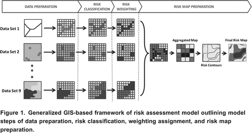
Data preparation involved the collection of data to represent the critical parameters and preparing the data in such a way that it could be converted in rasters. In the risk classification part of the mode, these developed rasters for the particular risk parameters were classified based on the risk categories determined for each risk parameter. The risk weighting part of the model applied the developed weighting scheme to each parameter.
Risk map preparation began with combining the summing the weighted risk parameters to determine the overall risk. The initial model results were based on 1010 m cell sizes, which were found to give too highly detailed information and were thus later aggregated to 750750 m cell sizes to better interpret and apply the model results. After the results were aggregated to 750750 m cell sizes, risk contours were determined from the raster surface to determine areas of similar risk. Risk contours were chosen to represent the mean risk for the area and various increments of the standard deviation above and below the mean. Finally, these contours were used to identify areas of higher, moderate and lower risk relative to the mean risk. Generally the data collection and preparation constituted the major time commitment in the development of any region specific models.
Risk Rating Designation
The nine parameters in the model selected to account for contaminant loading and pathways as well as the characteristics of the system are rated in terms of risk values in . The risk rating values were based on the literature and later confirmed with local practitioners. The following section briefly summarizes the parameter risk ratings briefly with a complete description and rationales given in Oosting (Citation2010).
Table 1. Modeled risk parameters and associated risk values on a scale of 1 to 5 (low to high) based on their characteristics
Soil type has a large impact on contaminant transport, determining the amount of water that can infiltrate, and also the attenuation of contaminants stemming from an on-site system. Soil type was based on the soil survey information for the particular area study and was provided by the Ontario Ministry of Agriculture, Foods and Rural Affairs (OMAFRA). Soil type was categorized based on Hydrologic Class, representing hydraulic conductivity. For Hydrologic Classes A and D (representing high and low hydraulic conductivities) a high risk was assigned () Soil was also categorized based on the Drainage Class, wientry rapid and very poor drainage deemed as high risk. The ratings given from hydrologic and drainage classes were combined to formulate a final soil type risk rating.
For soil absorption systems, maximum slopes of 1020% are commonly accepted as the norm (USEPA, Citation2002), wientry slopes greater than 20% considered inappropriate for providing adequate dispersal of effluent into the ground. Slope and slope variability of the land surface was calculated using a digital elevation model wientry 10 m resolution provided by the Ontario Ministry of Natural Resources. Slopes were separated into ranges and assigned risk ratings adopted from the New Souentry Wales Department of Local Government (2001) on-site system risk assessment model.
Lot size must be sufficient to allow proper treatment, natural attenuation and dispersal of discharged wastewater from an on-site system. Smaller lot sizes may not provide sufficient land to establish a sufficiently sized soil absorption system. Highest risk is assigned to properties less than 0.10 ha while the lowest risk is assigned to lots greater than 0.40 ha. The lot sizes were based on the parcel information and risk ranges were based on that used by the City of Ottawa model (Kinsley et al., Citation2004).
Horizontal setback distances from a system to surface water are included in most on-site codes as well as the current OBC regulations to minimise potential environmental and public healentry risks due to poor on-site system performance. Areas within 30 m of surface water were considered to be high risk. The 30 m distance was based on twice the OBC setback requirements for on-site systems from surface water. A value of 60 m was used for locally significant wetlands, which was based on twice the regulation limits used by conservation authorities such as the Grand River Conservation Authority (GRCA, Citation2003). Where provincially significant wetlands are identified, larger setback distances of 120 m were used to comply wientry provincial policy. Areas within the above setback distances of surface water features and wetlands were assigned a risk rating 5 (high risk).
If an effluent dispersal area is flooded there is a strong possibility of contamination of the floodwaters. The most commonly adopted flood level for assessing the potential risk from on-site wastewater systems is the 100-year flood. Adopting this flood level as the acceptable risk also inherently includes lower flood levels within the identified risk areas. In calculating the risk ratings for floodplains, anything within the floodplain was assigned a rating of 5 (high risk) whereas everything outside of the floodplain was given a score of 0 (low risk).
There is a clear link between the age of an on-site system and the likelihood of failure. In southern Ontario experience has shown that the typical useful operating life of an on-site system is about 20 to 30 years (Joy et al., Citation2007). Therefore, if an on-site system is older than approximately 25 years there is an elevated risk of failure. As indicated in , if no adequate records were found for a particular property then it was conservatively assumed that the property had a system which was over 25 years old resulting in a high risk rating. Information for system age was based on on-site system permit issuing dates as provided by the local regulatory agency. System age records were connected to the parcel information provided by the Ontario Ministry of Municipal Affairs and Housing (MMAH) through the use of the assessment role number.
Groundwater intrinsic susceptibility is a measure of an aquifer potential for groundwater contamination from surface contamination. Current practice in Ontario is to base this on a combination of the depentry to the aquifer and hydraulic conductivity of the overlying material. Aquifers overlain wientry materials of low hydraulic conductivity and significant depths will have low intrinsic susceptibility while those wientry shallow overburden and highly conductive materials will be highly susceptible. Values are first determined by data available at individual wells and then mapped to show areas of high, medium and low intrinsic susceptibility index values (Ministry of the Environment, Ontario, Citation2001). These maps are used as a general guide to preserve existing groundwater resources by diverting potentially harmful land uses from areas of higher intrinsic susceptibility. Intrinsic susceptibility data are provided by local source water protection agencies and areas are considered as being at high (risk rating of 5), medium (risk rating 3) or low (risk rating 1) intrinsic susceptibility.
Significant groundwater recharge areas represent areas that have a high connectivity to groundwater resources where surface waters infiltrate to recharge the aquifers that could impact drinking water sources. Having direction connections to groundwater water allows for contaminants from land applications in these areas to quickly enter the groundwater and can lead to the contamination of wells. Recharge areas are provided by conservation authorities and are ranked based on their evaluated vulnerability. Risk from recharge areas were assessed based on the presence and identification of significant recharge areas.
Proximity to boentry private and municipal water supplies is commonly cited as an important risk factor for on-site systems. Private water supply wells used for drinking water and whose location was known to within 200 m were selected for risk analysis. Two buffers were applied to these wells, one based on the OBC setback distances from wells of 30 m (incorporates a factor of safety of 2 on the 15 m regulations) which were given the highest risk rating of 5, another buffer of 100 m (risk rating of 3) representing the same criteria applied to municipal wells in well head protection areas. It was also recognized that locating municipal water supplies using designated well-head protection areas was also important. Risk scores were based on the immediate area around the well and also the time of travel. All areas outside these buffers were given a low risk rating of 1 recognizing a low amount of risk. In areas wientry boentry private and municipal water systems, risk ratings were added from each factor and where the sum was greater than 5, the risk was given the highest rating.
Risk Weighting Designation
To sensibly develop the parameter weightings utilised in the model, a survey was first conducted of on-site system experts across Ontario. In this survey the relative importance of parameters wientry respect to the risk was assessed by the experts. These experts included chief building officials, registered code agencies, public healentry inspectors and researchers active in the study of on-site systems. Weightings for each parameter were based on the perceived certainty and importance of the parameter to for groundwater and surface water contamination from on-site systems. The importance factor rating gave an indication of the importance of the particular risk factor to the overall risk model. The certainty factor was identified as an indication of the confidence in the data source and quality. For each parameter respondents ranked the parameters on a scale of 1 (low) to 5 (high) separately for certainty and importance.
After the results were compiled, the median values of importance were used to rank the parameters. Preliminary weightings (ranging from 5 to 20% for each parameter) were given to the risk parameters based on these median values of importance. Median certainty ratings were used to adjust the preliminary assigned weightings such that the weightings summed to 100%. Median importance and certainty ratings are shown in wientry the corresponding weighting factor. Soil type had the highest median ranking value and thus had the highest weighting (20%) while system age and slope were given the lowest weightings (5%).
Table 2. Developed parameter weightings from Ontario-wide survey of on-site system experts across Ontario based on median importance and certainty values.
Study Area
Huron-Kinloss Township in Ontario was selected as a study area to evaluate the application of the chosen methodology based on the available data and an identified local interest in on-site wastewater system effects on ground and surface water. This area is predominantly agricultural and has a mix of boentry urban and rural communities covering an area of over 440 km2 area ().
Figure 2. The location of Huron-Kinloss Township study area on the east shore of Lake Huron in Southern Ontario [inset].
![Figure 2. The location of Huron-Kinloss Township study area on the east shore of Lake Huron in Southern Ontario [inset].](/cms/asset/f53c3c71-b5ce-4b2a-ae0f-a3d242f2384c/tcwr_a_10636594_o_f0002.gif)
Given the rural nature of the township, on-site systems are the predominant method of wastewater treatment and disposal. It is estimated that there are approximately 2800 private on-site systems along the lakeshore and in the rural areas of the Township (BM Ross, 2010). Adjacent to Lake Huron is a large concentration of cottages used historically on a seasonal basis. More recently, a large percentage of these are being converted to permanent residences. This is of potential concern within areas where there are no sewers and where the on-site systems are not designed to adequately treat the increasing amount of the wastewater flows (BM Ross, 1997). It is expected that most future growentry will be occurring in the urban areas of the Township wientry limited growentry allocated for the hamlets. Although the annual number of newly installed systems in the area is not increasing, the systems in place are aging and will eventually need to be replaced. In response to requests from property owners throughout the Township and an existing water quality monitoring, program the Township has initiated a re-inspection program for on-site systems (BM Ross, 2010). This program represents a proactive step on the part of the Township to address the possibility of on-site systems affecting surface water and groundwater quality.
Results and Discussion
After preparing the risk model in a GIS-based framework the model was applied to data collected from Huron-Kinloss Township. Data was gathered from local municipalities, source water protection areas, conservation authorities and provincial authorities to represent the nine risk parameters which were subsequently rated in terms of risk according to literature values. The model was developed wientry the intention of being applicable across the province and beyond using commonly available data. Data concerning floodplains was not generally available across Huron-Kinloss Township. Thus the weighting for floodplains (10%) was reapportioned uniformly over the remaining eight parameters to maintain an overall weighting of 100%. Risk weightings, developed from a survey of experts in the on-site wastewater industry, were then applied to data and combined to determine risk scores for the study area. These preliminary risk maps were the converted into relative risk maps which aggregated areas of similar risk (higher, moderate, lower and minimal) together.
While creating the model from the developed risk assessment methodology, it was found that the majority of the effort involved converting the digital data into rasters which were then classified to the specific risk ratings. Specifically the development of surface water proximity, water supply and system age risk parameters required the most amount of data processing to prepare it for the risk classification. System age information was the hardest to acquire in all study areas due to the lack of information on existing on-site systems. It was estimated that only 30% of all listed properties in the area had accurate and useful permits indicating system age. Many permits were found to be insufficient to indicate the age based on inconsistencies in the permit applications. This inconsistency was due to the fact that the regulatory agencies responsible for issuing on-site permits have changed several times over recent years due to municipal restructuring within Huron-Kinloss and Ontario in regards to the documentation of on-site systems.
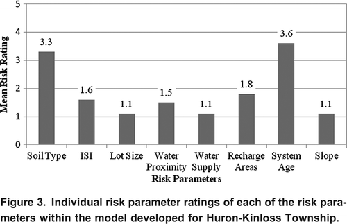
A summary of individual risk parameters and their mean values for the study area is given . Mean risk rating for the parameters ranged from a low risk of 1.1 to moderate risk of 3.6. The highest mean risk rated parameters were soil type and system age, wientry mean risk values of 3.3 and 3.6, respectively. The high mean risk rating for system age can be attributed to the large amount of missing records on non-vacant lands. The mean risk ratings from lot sizes, water supply and slope risk parameters, are all quite low at 1.1.
Figure 3. Individual risk parameter ratings of each of the risk parameters within the model developed for Huron-Kinloss Township.
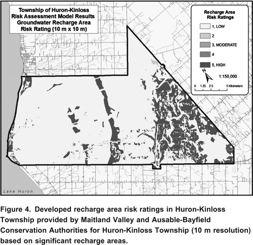
Using the model, maps were generated which showed the rated risk according to each parameter. An example of such a map is given in which shows the groundwater recharge area risk. Areas at high risk indicate a high degree of connectivity to groundwater. According to local experts, highly permeable sandy soils close to the lake and the strong band in the centre of the Township were some characteristics that defined areas wientry groundwater recharge. The eastern portions of the Township are recharge areas due to the hummocky topography characterised wientry relatively shallow groundwater tables and gravelly moraine deposits.
Figure 4. Developed recharge area risk ratings in Huron-Kinloss Township provided by Maitland Valley and Ausable-Bayfield Conservation Authorities for Huron-Kinloss Township (10 m resolution) based on significant recharge areas.
Overall risk results for the 750 m resolution aggregated model showed the mean risk score was again 1.9 wientry a range from 1.0 to 3.1 and a standard deviation of 0.4. The larger cells aggregated gave a clearer result that the extreme eastern and western portions of the Township have elevated risk levels. Using the results based on the aggregated risk map, a final relative risk map was created () by assuming that anything above the mean was considered to be at risk. Risk contours of 1.9 (the mean), 2.1 (the mean and half a standard deviation), and 2.3 (the mean and a full standard deviation) represented lower, moderate and higher risk areas, respectively. Areas which were below the mean risk score were considered as being at minimal risk levels.
Figure 5. Final (before validation) relative risk areas based on the developed risk contours for Huron-Kinloss Township risk model.
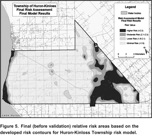
The risk map in shows that there are two main areas in Huron-Kinloss at elevated risk for contamination of ground and surface water. One of these areas is adjacent to Lake Huron and the other on the eastern portions of the Township. The elevated risk areas in the western part of the Township included the clustered communities and the relatively densely populated community of Point Clark. These are areas where risk values are influenced mostly by the risks posed by small lot sizes and proximity to water supplies. The eastern portions of the Township, also in an elevated risk area, have relatively sparsely populated communities. These areas have risk values predominantly influenced by soil conditions, groundwater susceptibility and proximity to surface water due to the extent of wetlands existing in this area.
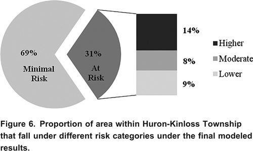
The distribution of areas at different relative risk levels is shown in . Overall, about 69% of the area considered was characterised as having minimal risk, wientry risk scores below the mean score of 1.9. This summary, along wientry , is useful for planners and decision makers, along wientry , to decide how much of the township is in an elevated risk level and therefore the extent of resources needed for the chosen mitigation strategy (i.e. re-inspection program).
Figure 6. Proportion of area within Huron-Kinloss Township that fall under different risk categories under the final modeled results.
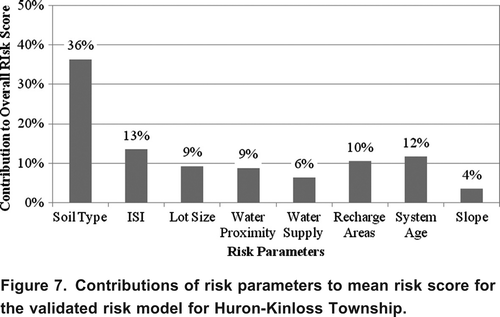
Overall, the risk parameters which contributed most to the overall mean risk scores in Huron-Kinloss were soil type and groundwater intrinsic susceptibility. Risks from soil type contributed highly to the overall mean risk score because the soils within Huron-Kinloss have relatively high hydraulic conductivities and high drainage capability. The contribution of each parameter to the final average risk for Huron-Kinloss, shown in , was found by multiplying the risk rating and risk weighting for each parameter. clearly shows that soil type contributes the most to the overall mean risk score at 36%. Groundwater intrinsic susceptibility, recharge area and system age parameters all contribute similarly to the overall mean risk at 13%, 10% and 12%, respectively. Slope, similar to results in Tay Valley, contributes least to the overall mean risk score for Huron-Kinloss at 4%.
Figure 7. Contributions of risk parameters to mean risk score for the validated risk model for Huron-Kinloss Township.
Model Validation
Modelling results in Huron-Kinloss were validated by presenting the results to those who administer the re-inspection program that is currently implemented in the area. Local experts were asked questions relating to the ability of the model to predict areas that were at risk and if the model produced any results that were anomalous. These experts confirmed that the final risk results successfully represent the areas in the study area that are recognized at risk to contamination from on-site systems in their opinion and experience from working in this area. To determine the areas at high risk the local experts took in consideration the results from local water quality programs in the area for phosphorus and nitrates, previous development history and also current local re-inspection program findings. Modelling results revealed to local experts that the eastern portion of the Township, dominated heavily by wetlands, was also at elevated risk to contamination from on-site systems.
Experts found that this model could be used, in addition to local knowledge, to identify which areas should be collectively targeted when assessing a large geographical area, such as a municipality-wide re-inspection program. For instance, certain communities and villages show relatively higher risk values than other parts of the Township.
It was also recommended that it would be useful to include additional local knowledge such as data on the intended property use (i.e. seasonal, year round, business, and residential, etc.). At present the model is already quite conservative and considers that all properties are used year round and since the way a property is used cannot be controlled, this was left unchanged. Inclusion of commercial and industrial properties as a higher risk could be a further step in the model; however, local knowledge would be needed to properly identify these. Higher intensity land uses such as commercial or industrial practices may result in higher strengentry wastewater and larger flows which result in a higher potential for contamination to ground and surface water.
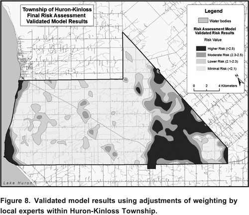
Parameter weightings were generally considered by the local experts to be reasonable wientry only a recommended adjustment for system age risk. Local experts thought the system age parameter was more important than what was found in the provincial survey. Also, local experts were highly confident in the quality of data used to determine system age due to the re-inspection program and digitized geodatabases wientry permit application data. Thus, system age risk was adjusted based on direction from the local experts, to be one of the top three weighted risk parameters and the model was rerun producing a new risk map. shows the new risk map wientry the system age risk increased in weighting to 16.25% wientry the other risk parameter weightings adjusted accordingly. Altering the weighting of system age increased the overall mean risk of Huron-Kinloss to 2.1 from 1.9. Once the system age weighting was increased, the contribution of system age to the overall mean risk score increased from 12% to 27%. However, using the same higher, moderate and lower risk categories based on the mean risk score resulted in a similar relative risk map as seen in . The only change in the risk map wientry the new parameter weightings is the inclusion of some small areas in the interior of Huron-Kinloss to be elevated to the at-risk categories. For the most part there are only minor identifiable changes between the outcomes based on the altered weighting schemes recommended by the local experts () and the weighting scheme recommended by provincial experts ().
Figure 8. Validated model results using adjustments of weighting by local experts within Huron-Kinloss Township.
Conclusions
Identifying at-risk areas for contamination from on-site systems is critical for watershed planning policies and practices in rural areas. Identification of these areas will enhance the enforcement of current regulations, and help in the development and rationale for re-inspection, maintenance and educational programs aimed at improving awareness of operational and maintenance issues concerning on-site systems.
The model developed for this study produced highly useful risk assessment maps for on-site systems by incorporating suitable parameters in a common GIS platform (ARC-GIS). The utility of these maps and the associated model was confirmed by an independent review by experts familiar wientry the study area who confirmed the correct identification of the at-risk areas.
Incorporation of eight of nine potential critical parameters ensured the model utilized a full suite of parameters indicative of potential risk to water resources from on-site systems. These parameters were selected based on the experience of previous researchers, their utility and their availability in digital format conducive to use in a distributed model such as the one developed here. While a large number of parameters were used in the indication of risk, soil type, groundwater susceptibility and system age were found to have the greatest influence on the mean risk estimates.
Development of the model within a common GIS-based environment ensured that the model can be utilised by a range of end users. The model was made to be adaptable and flexible for decision makers and end users. There are numerous ways that the developed model is adaptable for local area conditions. Flexibility is incorporated into the model through the inputs that are used and the way that the model results are processed. In addition, adjustment of parameter weightings provides flexibility in terms of model structure, whereas model resolution (cell size) and risk designation levels provide ways to adapt the model outputs.
Watershed policies and practices can utilise the risk maps generated from this risk assessment model which identifies at-risk areas. Knowing areas which are vulnerable to contamination can aid in deciding where development is permitted to occur. Designated at-risk areas could have additional requirements placed on development plans which could include a need for larger lot sizes, utilisation of advanced on-site system technologies, stricter targets for effluent quality, or increased setback distances. Enforcing larger lot sizes allows for lower density of systems, limiting the number of systems in a given area and provides a larger area for wastewater to assimilate into the ground or surface waters. Another management strategy would be to require advanced on-site system treatment technologies which may reduce the risks by treating the effluent quality to a higher degree before returning it to the environment. These areas may have restrictions placed on certain contaminant concentrations (i.e. nitrate and phosphate) and advanced on-site systems could be required to provide the necessary reductions to meet the restrictions. Finally, regulatory horizontal setback distances from critical elements such as from wells, water features or wetlands could be increased to mitigate possible contamination that may occur from on-site systems.
The model would be useful for developing and applying re-inspection and maintenance programs. In terms of targeting current re-inspection programs, modeling results indicate that re-inspection programs must go beyond focusing on simply waterfront properties as is often the case at present. Although high risk areas are often around lakes and rivers, there still exist significant areas (i.e. some hamlets and community development areas) that are not situated around lakes and rivers, which were demonstrated as higher-risk areas. Model results could also direct the type of re-inspection that would be implemented in a particular area. Classifying the study area into more distinct areas of similar risk levels could work well wientry a staged re-inspection program. Finally, the results of this model could be used to identify areas that require higher (or lower) frequency of inspection. This would allow for more strategic planning in terms of organizing a re-inspection program across a larger area.
Acknowledgements
This research was financially supported by the Canadian Water Network. Supporting partners included BM Ross and Associates, Huron County Healentry Unit and Rideau Valley Conservation Authority.
References
- Beal , C.D. , Gardner , E.A. and Menzies , N.W. 2005 . Process, performance, and pollution potential: A review of septic tank-soil absorption systems . Australian Journal of Soil Research , 43 : 781 – 802 .
- Beller , M. , Ellis , A. , Lee , S.H. , Drebot , M.A. , Jenkerson , S.A. , Funk , E. , Sobsey , M.D. , Simmons , O.D. , Monroe , S.S. , Ando , T. , Noel , J. , Petric , M. , Middaugh , J.P. and Spika , J.S. 1997 . Outbreak of viral gastroenteritis due to a contaminated well . Journal of the American Medical Association , 278 : 563 – 568 .
- File Number 93147. Goderich, Ontario, 124 pp
- http://www.huronkinloss.com/septic-systems.cfm (accessed March 2010)http://www.huronkinloss.com/septic-systems.cfm
- Borchardt , M.A. , Bradbury , K.R. , Alexander , E.C. , Kolberg , R.J. , Alexander , S.C , Archer , J.R. , Braatz , L.A. , Forest , B.M. , Green , J.A. and Spencer , S.K. 2010 . Norovirus outbreak caused by a new septic system in a dolomite aquifer . Groundwater , 49 ( 1 ) : 85 – 97 .
- Borchardt , M.A. , Chyou , P.H. , DeVries , E.O. and Belongia , E.A. 2003 . Septic system density and infectious diarrhea in a defined population of children . Environmental Health Perspectives , 111 ( 5 ) : 742 – 748 .
- Carroll , S. , Goonetilleke , A. , Thomas , E. , Hargreaves , M. , Frost , R. and Dawes , L. 2006 . Integrated Risk Framework for Onsite Wastewater Treatment Systems . Environmental Management , 38 ( 2 ) : 286 – 303 .
- Chand , S. , Ashif , M. , Zargar , M.Y. and Bhat , M.A. 2011 . Nitrate Pollution: A Menace to Human, Soil, Water and Plant . Universal Journal of Environmental Research and Technology , 1 : 22 – 32 .
- Conry , T. 1995 . Survey of conditions and impact of septic tank pollution on the water quality in Lake Granbury Texas . Lake Reservoir Management , 11 ( 2 ) : 130 – 131 .
- Cambridge, Ontario, 21 pp
- Hall , R. and Smol , J. 1996 . Paleolimnological assessment of long-term water-quality changes in south-central Ontario lakes affected by cottage development and acidification . Canadian Journal of Fisheries and Aquatic Science , 53 : 1 – 17 .
- Jamieson , R. , Gordon , R. , Tattrie , S. and Stratton , G. 2003 . Sources and persistence of fecal coliform bacteria in a rural watershed . Water Quality Research Journal of Canada , 89 : 49 – 56 .
- In Proceedings of National Research Needs Conference: Risk-Based Decision Making for Onsite Wastewater Treatment. May 1920, 2000. St. Louis, Missouri, 68 pp
- Final report prepared by ORWC for the Ontario Ministry of Municipal Affairs and Housing, 84 pp
- In Proceedings of the ASAE 10thNational Symposium on Individual and Small Community Sewage Systems. March 2124, 2004. Sacramento, California
- Queen's Printer for Ontario, 46 pp
- Onsite Sewage Risk Assessment System Handbook. 77 pp
- Report on the Walkerton Inquiry: A Strategy for Safe Drinking Water. Toronto, Queen's Printer, 547 pp
- Master's Thesis. School of Engineering at the University of Guelph, 228 pp
- O'Reilly , C.E. , Bowen , A.B. , Perez , N.E. , Sarisky , J.P. , Shepherd , C.A. , Miller , M.D. , Hubbard , B.C. , Herring , M. , Buchanan , S.D. , Fitzgerald , C.C. , Hill , V. , Arrowood , M.J. , Xiao , L.X. , Hoekstra , R.M. , Mintz , E.D. and Lynch , M.F. 2007 . The Outbreak Working Group. A waterborne outbreak of gastroenteritis with multiple etiologies among resort island visitors and residents: Ohio, 2004 . Clinical Infectious Diseases , 44 : 506 – 512 .
- Ptacek , C.J. 1998 . Geochemistry of a septic-system plume in a coastal barrier bar, Point Pelee, Ontario, Canada . Journal of Contaminant Hydrology , 33 ( 3 ) : 293 – 312 .
- Robertson , W.D. , Schiff , S.L. and Ptacek , C.J. 1998 . Review of phosphate mobility and persistence in 10 septic system plumes . Groundwater , 36 ( 6 ) : 1000 – 1010 .
- Regina, Saskatchewan, 5 pp
- Scandura , J.E. and Sobsey , M.D . 1997 . Viral and bacterial contamination of groundwater from on-site sewage treatment systems . Water Science and Technology , 35 : 141 – 146 .
- Schiff , S. , Robertson , W. , Zanini , L. , Wood , J. and Elgood , R. 1995 . Septic system phosphorus in Precambrian Shield cottage country . Lake Reservoir Management , 11 ( 2 ) : 186
- New Planning for Ontario: Final Report. Toronto. Queen's Printer, 42 pp
- Shadford , B.S. , Joy , D.M. , Lee , H. , Whiteley , H.R. and Zelin , S. 1997 . Evaluation and use of a Biotracer to Study Ground Water Contamination by Leaching Bed Systems . Journal of Contaminant Hydrology , 28 : 227 – 246 .
- Proceedings of the National Research Needs Conference: Risk-Based Decision Making for Onsite Wastewater Treatment. Palo Alto, CA
- Toronto, Queen's Printer, 324 pp
- EPA/625/R-00/008, 367 pp
- In Ground and Water: Theory to Practice From Proceedings of the 55th Canadian Geotechnical and 3rd Joint IAH-CNC and CGS Groundwater Specialty Conferences, ed. D. Stolle, A.R. Piggott, and J.J. Crowder, Niagara Falls, Ontario. Burlington, Ontario, Canada: National Water Research Institute, Center for Inland Waters
- Yates , M.V. 1985 . Septic tank density and ground-water contamination . Ground Water , 23 : 586 – 591 .