Abstract
The Soil Water Assessment Tool (SWAT) model was calibrated for a small watershed with extensive irrigation, low runoff, and a short (2004-2007) period of record in the semi-arid region of the Canadian prairies. The watershed is located on a segment of a river. The net flow between the upstream (inlet) and downstream (outlet) locations of the reach comprises only a fraction of the streamflow at the outlet. This type of watershed is rarely investigated and generally different from the pear shaped single outlet watersheds presented in SWAT literature. The objectives of this study were to determine if SWAT could be calibrated and validated on this unique watershed using one- and two-way calibration-validation methods, and to determine the effect of a variable climatic record on calibrated and validated parameters. To study the effect of a variable climatic record on the calibrated parameters for this watershed a two-way calibration verification scheme that involved two scenarios was used. Scenario 1 involved calibration using 2004 (average precipitation) and 2005 (above average precipitation) and validation on 2006 and 2007 (both below average precipitation). For scenario 2, the calibration and validation periods were reversed. A third scenario utilized the period of 20042006 for calibration and reserved the 2007 data for validation. The objective criteria used to evaluate model performance included decomposition of the Root Mean Square Error (RMSE) into systematic and unsystematic error, the Nash-Sutcliffe efficiency coefficient (EF) and the coefficient of determination (R2) as model best fit objective functions. The calibration results were satisfactory for scenarios 1 and 3. The calibration of scenario 2 and the validation results for all three scenarios were unsatisfactory. The objective criteria calculated separately for each year in the calibration records showed the calibration results were satisfactory for 2005 only, which is the only wet year in the observed record with above average precipitation. Thus, calibrated parameters were mainly influenced by the 2005 wet season. Therefore, SWAT model calibration on a mixed record of wet and dry conditions will reflect the hydrological processes dominant during wet conditions rather than those observed during dry ones. Although we conclude that the SWAT model could not be successfully validated on this unique watershed, a longer record may result in successful calibration and validation.
Le modle Soil and Water Assessment Tool (SWAT) (outil d'valuation de l'eau et du sol) a t talonn pour un petit bassin hydrographique caractris par une irrigation grande chelle, un faible ruissellement et une courte priode d'enregistrements (de 2004 2007) dans la rgion semi-aride des Prairies canadiennes. Le bassin est situ sur un segment d'une rivire. L'coulement net entre l'amont (entre d'eau) et l'aval (sortie d'eau) du tronon reprsente seulement une fraction de l'coulement fluvial l'exutoire. Ce type de bassin hydrographique fait rarement l'objet d'tudes et diffre en gnral des bassins exutoire unique en forme de poire dont fait tat la documentation SWAT. Les objectifs de la prsente tude consistaient d'une part dterminer si le modle SWAT pouvait tre talonn et valid pour ce bassin hydrographique unique l'aide de mthodes d'talonnage et de validation unilatrales et bilatrales et, d'autre part, dterminer l'effet de l'enregistrement de la variabilit climatique sur les paramtres talonns et valids. Pour tudier l'effet d'un enregistrement de variables climatiques sur les paramtres talonns pour ce bassin hydrographique, un plan d'talonnage et de vrification bilatral qui impliquait deux scnarios a t utilis. Le scnario 1 prvoyait l'talonnage des donnes de prcipitations moyennes de 2004 et de prcipitations suprieures la moyenne de 2005 et la validation des donnes de prcipitations infrieures la moyenne de 2006 et de 2007. Dans le cas du scnario 2, les priodes d'talonnage et de validation ont t inverses. Un troisime scnario consistait utiliser la priode de 2004 2006 pour l'talonnage et rserver les donnes de 2007 des fins de validation. Les critres objectifs qui ont servi valuer le rendement du modle englobaient la dcomposition de l'cart-type en une erreur systmatique et en une erreur non-systmatique, le coefficient d'efficience de Nash et Sutcliffe (CE) et le coefficient de dtermination (R2), car le modle correspond le mieux aux fonctions objectives. Les rsultats de l'talonnage ont t satisfaisants dans le cas des scnarios 1 et 3. L'talonnage du scnario 2 et les rsultats de la validation pour l'ensemble des trois scnarios ont t jugs insatisfaisants. Les critres objectifs calculs sparment pour chaque anne dans les enregistrements d'talonnage ont rvl que les rsultats de l'talonnage se sont avrs satisfaisants pour 2005 uniquement, la seule anne humide de l'enregistrement au cours de laquelle des prcipitations suprieures la moyenne avaient t observes. Donc, la saison humide de 2005 est le principal facteur ayant influ sur les paramtres talonns. Par consquent, l'talonnage du modle SWAT en fonction d'un enregistrement mixte de conditions humides et sches refltera les processus hydrologiques dominants pendant les priodes humides plutt que ceux observs pendant les priodes sches. Bien que nous en arrivions la conclusion que le modle SWAT n'a pas pu tre valid avec succs dans le cas de ce bassin hydrographique unique, il se pourrait qu'un enregistrement plus long se traduise par un talonnage et une validation couronns de succs.
Introduction
On a watershed scale, simulation models are conceptualized on a baseline hydrologic balance equation, and consider the influence of different management practices on each of its components. The Soil Water Assessment Tool (SWAT) (Arnold et al., Citation1998) is a leading model that belongs to this category. A review article by Gassman et al. (Citation2007) pointed out the fundamental strength of SWAT model as a comprehensive package of hydrological and hydraulic processes that allowed its widespread use in the simulation runoff and water yield (Anand et al., Citation2007; Mekonnen et al., Citation2009) and soil water content (Deliberty and Legates, Citation2003; Mapfumo et al., Citation2004; Narasimhan et al., Citation2005), the evaluation of the effect of agricultural and structural BMPs on water quality (Stewart et al., Citation2006; Gollamudi et al., Citation2007; Gitau et al., Citation2008) and the assessment of the effectiveness of structural BMPs on reducing soil erosion (Bracmort et al., Citation2006; Yang et al., Citation2009). Gassman et al. (2007) recognized that SWAT's strength also reflects its weakness in the sense that empirical and semi-empirical depictions of some processes may be overly simplified and require further refinement.
Qi and Grundwald (Citation2005) criticized the typical practice of calibrating and validating SWAT on a single outlet for the whole drainage area of a watershed as it does not account for the variability within the watershed. Alternatively, they suggested a spatial approach by the calibration and validation of SWAT at several gauge stations of sub-watersheds within a larger watershed. The multisite approach was previously used by Santhi et al. (Citation2001a), White and Chaubey (Citation2005) and Cao et al. (Citation2006). However, the multisite approach maintains the typical form of SWAT case studies in that each site is by itself a single outlet watershed. Other forms of watersheds are either not reported in the literature or rarely investigated. In this study we consider the case of a small watershed located along a short distance specified by an upstream and downstream streamflow observation sites on a river reach (east to west direction).
The calibration process has been facilitated by the development of automatic calibration techniques that have transformed the tedious and subjective manual calibration into a more time efficient and objective process. Duan et al. (1992) developed an approach known as the Shuffle Complex Evolution method (SCE) that incorporates the optimization of independent groups of inputs, and systematic shuffling between the groups. The SCE evaluation (Gan and Biftu, Citation1996) on 8 dry to wet catchments showed that the validation results for the wet catchments were better than those for the dry ones. Streamflow simulations often require fitting criteria different than those for baseflow, which is usually substantially lower than the runoff resulting directly from rainfall. Therefore, Deb et al. (Citation2002, as reviewed by Bekele and Nicklow, Citation2007) proposed the Non-dominated Sorting Genetic Algorithm (NSGA-II) that included the main ideas of the SCE in addition to the capability of handling the automatic calibration using multiple objective functions.
A long observed record has been often pointed out as prerequisite for successful calibration and validation of SWAT (Muleta and Nicklow, Citation2005; Bekele and Nicklow, Citation2007; Ndomba et al., Citation2008). Sorooshian and Gupta (Citation1995) (as reviewed by Muleta and Nicklow, Citation2005, and Bekele and Nicklow, Citation2007) recommended that number of observed data points should at least be 20 times the number of the calibrated parameters. However, the climatic variability within the observed record was another drawback that was revealed by Chanasyk et al. (Citation2003), where a SWAT model calibrated on a wet season clearly under-performed during the validation stage that consisted of two dry seasons. Wu and Johnston (Citation2007) calibrated SWAT for two data sets representing drought and average climatic conditions. Both calibrated models were compared using a common validation period dominated by below average precipitation seasons. The drought calibrated version of SWAT outperformed the average calibrated version. Their findings also demonstrated the influence of climatic conditions on the calibrated SWAT parameters. Singh et al. (Citation2005) calibrated SWAT using a representative record of different climatic conditions, however, validation showed a tendency for SWAT to underestimate low flows and overestimate high flows. Similar observation of SWAT underperformance during wet conditions was reported by Chu and Shirmohammadi (Citation2004) and Govender and Everson (Citation2005).
Klemes (Citation1986), who discussed the issue of climatic transposability, argued in favor of a two-way calibration-validation, suggesting that a conceptual model should be validated at least twice on different portions of the observed record. He also described a differential split sample test to ensure the model reliability under different climatic conditions. The differential split-sample test requires rearrangement of the observed record into wet and dry segments based on precipitation. To test the suitability of a model for wet conditions, it should be calibrated on the dry segment of the record and validated on the wet segments. The opposite process is required to validate a model for dry conditions.
The two-way calibration-validation is not as popular as the simple (one-way) split sample calibration validation where the model is calibrated using the main portion of the observed data and the remaining fraction of the record is used for validation. The one-way procedure is logical; however, its major drawback is the implicit assumption of a resulting unique set of calibrated values, which generally does not hold for nonlinear, interdependent conceptual models like SWAT (Gupta et al., Citation1998). In addition, it requires sufficient data points in the calibration stage to train the model to respond to a reasonable spectrum of rainfall, soil moisture and climatic conditions.
On the other hand, the possible outcome of a two-way calibration validation scheme is two scenarios that can be different or statistically similar to each other within specific confidence interval limits. Further consideration of the intermediate and final output may be required to resolve any discrepancies between the calibrated parameters. However, in many instances the two way calibration-validation scheme was found to be beneficial in model evaluation (Patry and Marino, Citation1983; Barber et al., Citation2004; Zhang and Savenije, Citation2005).
The first objective of our study was to successfully calibrate and validate the Soil Water Assessment Tool (SWAT) for a small watershed defined by an inlet and outlet along the main reach and with a short period of record. The second objective was to study the effect of a climatically variable record on the calibrated parameters and model outputs by using a two-way calibration-validation, and also a split sample calibration-validation scheme.
Methods
Site Description
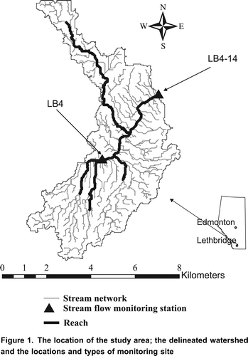
The study watershed is part of the Lower Little Bow (LLB) watershed, located in southern Alberta, approximately 40 km north of Lethbridge, Alberta, Canada, comprising an area of approximately 34 km2 (). The watershed crop cover includes cereals, range, pasture and seed oil comprising approximately 28, 18, 48, and 6% of the watershed's total area, respectively. About half of watershed is irrigated by centre pivot systems. A portion of the irrigated water is supplied by the Lethbridge Northern Irrigation District, and the remainder comes directly from the river. The excess irrigation water is returned to the river. The average seasonal (April to October) rainfall is 290 mm.
Figure 1. The location of the study area; the delineated watershed and the locations and types of monitoring site
SWAT Model Construction and Inputs
The SWAT model was constructed using ArcSWAT Version Beta 0.7.1, an interface between the geographic information system software ArcGis 9.1 and SWAT. The data requirements for the ArcSWAT interface consisted of climatic data, on farm agricultural practices, and three GIS layers, namely the digital elevation model (DEM), a soil map, and a land use map.
A digital elevation model (DEM) was created using air photos at a scale of 1:30,000. The data were collected at a mesh spacing of 10 m and refined using information on the slope, channels and drainage divides. The resulting DEM was imported into ArcView and interpolated using the Inverse Distance Weight (IDW) method. To delineate the WEBs watershed, the upstream and downstream monitoring points were considered as the watershed inlet and outlet, respectively.
The land use and crop cover map was based on the Alberta township system (36 sections; each 1 mile x 1 mile, of land). The farmers reported their on-farm agricultural practices, which included the type and rate of fertilizer applications, and the types of crops cultivated in each quarter section. A GIS polygon shape layer was prepared; each quarter section was represented by a polygon, and the appropriate attributes and properties were added to each polygon. Three land use maps were prepared to represent the variation in crop cover during the period 20042006, inclusive.
Soil data from the Alberta soil inventory database (AGRASID 3.0) were obtained in the form of GIS polygon shape files representing the soil series, and database tables containing the attributes and properties of the available soil series (Alberta Agriculture and Rural Development, Citation2007). The database tables were linked with the shape files, and then the major soil information was extracted. Soils in the watershed belong to three main soil orders at the subgroup level: Orthic Dark Brown Chernozems, Rego Dark Chernozems and Orthic Regosols encompassing 63.4, 16.9 and 19.4% of the watershed area, respectively (). Based on the drainage class (), the soils in watershed most probably belong to the A or B hydrologic groups (Neitsch et al., Citation2002).
Table 1. The drainage class, group level soil classification and distribution of the soil series within WEBs LLBow watershed (Alberta Agriculture and Rural Development, 2007).
A total of 251 soil textural samples were collected in the fall of 2006 in order to refine the watershed's soil characterization. Clay and sand contents were determined at the soil sample locations and then interpolated for the entire watershed using the Inverse Distance Weight (IDW) method. Both the Agrasid 3.0 database and the collected soil samples were used to establish reasonable ranges of soil input parameters for further use in the SWAT model calibration process.
The climatic data consisting of precipitation, relative humidity, wind speed, solar radiation, and minimum and maximum air temperatures were acquired from the Iron Springs weather station (approximately 16 km from the main reach), which is available online from the Irrigation Management Climate Information Network (IMCIN) managed by Alberta Agriculture and Rural Development. The climatic record was also supplemented with data collected from the Lethbridge weather station (approximately 40 km of the main reach) that was available online from Environment Canada's National Climate Data and Information Archive.
The farmers in the LLB watershed usually irrigate on a weekly basis with average irrigation depths of 38 mm and 44 mm for cereals and grasses, respectively. The irrigation schedule for the years 20042007 was re-constructed based on the average daily evaporation published by Alberta Agriculture, Food, and Rural Development, which is used by the farmers in the LLB as a guideline. Therefore the irrigation practices in the watershed probably follow a fixed irrigation pattern rather than a flexible irrigation practice triggered by a depletion criterion of the soil water content. The average potential daily evaporation was compared with rainfall depth and an irrigation event was considered whenever the deficit, defined as the difference between cumulative potential evapotranspiration and cumulative rainfall, exceeded 38 mm for cereals and 44 mm for grasses. Furthermore it was assumed that withdrawal from the main reach occurred over a period of a few days to avoid an undue demand and thus the risk of drying up the river.
Table 2. Summary of three modeling scenarios used in this study.
The simulated irrigation requirements for most crops are within the average reported by the LNID, which is approximately 300 mm. The simulated alfalfa and grass irrigation requirements are well above 600 mm or double the average during a dry season.
shows the flow rate at the upstream and downstream stations, LB4-14 and LB4, respectively. Comparing the flow rates at the two locations reveals that approximately 10% of streamflow had originated within the watershed area. Such a small flow rate difference between the downstream and upstream sites could prevent meaningful simulation of the hydrological processes in the watershed, since most of the flow was coming from the upstream site. Therefore, SWAT was used to simulate the net streamflow, defined as the difference in the volume discharge between the inlet (upstream site) and the outlet (downstream site).
Figure 2. Observed streamflows during 2004-2007 at the inlet and outlet of the watershed.
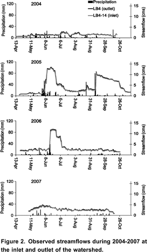
These streamflow incremental differences were not a direct response to rainfall as evident from the observed data. The record rainfall events that occurred during May and September 2005 were associated with increasing streamflow discharge at the inlet of the watershed without a similar impact on the incremental difference between the inlet and the outlet, indicating that the direct effect of rainfall on the streamflow discharge was generated upstream of the inlet. The main inference from this observation is that the ground water discharge and/or the return flow of excess irrigation water are likely important sources of discharge to the main reach.
The irrigation water comes from two sources: from an outside source provided by the Lethbridge Northern Irrigation District (LNID) to 862 ha located south of the main reach. For the remaining 704 ha of irrigated land in the watershed, water is diverted from the main reach of the river. The return flow is calculated at the end of each SWAT run as the difference between the estimated potential water requirements supplied by the LNID and actual irrigation in the watershed.
The watershed was subdivided into 7 sub-basins to coincide with water quality and streamflow monitoring sites. The irrigated areas were merged with land use maps, and hydrological response units (HRUs) were defined using thresholds of 14 and 25% for the land use and soil type, respectively. The high threshold for soil type was justified to avoid the creation of marginal HRUs, which will only increase the computational burden without improving the representation of the watershed heterogeneity. The resulting 29 HRUs consisted of four types of land use (pasture, barley, irrigated pasture, and irrigated barley) and seven soil series (Kessler, Whitney, misc. undiff. Mineral, Crowfoot, misc. eroded, Lethbridge and Readymade). However, some of the HRUs were redrawn manually to preserve the total irrigated areas, resulting in a final count of 40 HRU(s). To simplify the calibration process, the model structure was based on 2005 land use and was used for all years. This is justified based on the similarity of land use and crop cover through the period of 2004-2006 (data not shown), and the fact that crop rotation only existed in limited areas, without affecting the proportions of the major crop cover classes, namely barley, pasture, and range.
Simulation began on January 1, 2003 to allow for equilibration of the initial soil moisture content and shallow and deep aquifer storages, before the onset of the observed period that began on April 2004. It was assumed that the pasture was established before 2004 and a no kill harvest (Neitsch et al., Citation2002) operation was performed on September 30 of every year, with a harvest efficiency of 80% removed biomass and 20% as residue conversion. The agricultural practices for barley consisted of primary and secondary tillage on April 20 and April 25, respectively, following by seeding on May 1. The crop was harvested on August 15. The potential heat units (PHUs) for each crop were calculated from the average cumulative heat units during the simulation. The default values of SWAT crop database were accepted for the base temperature for plant growth, maximum leaf areas index (LAI) and other plant parameters. For the fertilized farms, nitrogen and phosphorus fertilizers were applied on April 15 of each year.
Objective Function and Goodness of Fit
The Nash-Sutcliffe efficiency coefficient (EF) (Nash and Sutcliffe Citation1970) is commonly employed as an objective function to measure the ability of hydrological models to reproduce the observed data, thus, their reliability as predictive and decision making tools. The EF is based on a base line model, usually the mean of the observed data. Legates and McCabe (Citation1999) noted the EF is sensitive to high values due to the squared differences. As a result the EF tends to overestimate larger values and underestimate or neglect lower values (Krause et al., Citation2005). In contrast the R 2 is limited in that it only provides a correlation measure for the linear relationship between the simulated (P) and the observed (O) data. However, Krause et al. (2005) noted that perfect or semi perfect relationships of remarkably high R 2 can be obtained even with a significant divergence in magnitude between P and O by manipulating the values of the intercept (A) and the slope (B). Legates and McCabe (1999) proposed that A and B values that differ significantly from 0.0 and 1.0, respectively, indicate deficiencies in the model, and should be weighed against the R 2 values.
The EF values tend to deteriorate as the A and B depart from their optimal values, but unlike R 2 the EF is unbounded at the lower end as it ranges from minus infinity to 1.0. Legates and McCabe (1999) regarded this as an advantage because the zero value of EF indicates that the model performance is as good a predictor as the baseline model; thus creating a reference point for all other EF values. Hence, EF >0 and EF <0 indicate a better and worst model performance, respectively, than the baseline model. While R 2 bounded values are indicative of the percentage of variability in the observed data explained by the model (e.g., R 2 =0.7 means 70% of variance in the observed data is explained by the model).
Another objective function that is widely used is the root mean square of error (RMSE). The RMSE is also based on the squared difference between the predicted and the observed values, similar to the EF. The interpretation of RMSE is often controversial since its magnitude is not relative and it is useful only for the purpose of comparison with other models. A single RMSE value is not indicative of the reliability of the model (Willmott Citation1982). Willmott (1982) and Willmott et al. (Citation1985) suggested that it is more useful to decompose the RMSE into systematic and unsystematic components. The systematic root mean square of error (RMSE s ) is expressed as (Willmott, Citation1982)
In this paper, a model should satisfy the following two criteria for satisfactory performance:
RMSEu > RMSEs and
EF 0.5 as recommended by Moriasi et al. (Citation2007) or R2 0.6 combined with 0.1 >A -0.1 and 1.2>B 0.8. Santhi et al. (Citation2001b), Chung et al. (Citation2002), and Green and Van Griensven (2008) suggested an R2 0.5 as an indication of adequate performance. However, to consider the effect of A and B, we increased the R2 threshold to 0.6 and imposed restrictions on the A and B values.
Automatic Calibration
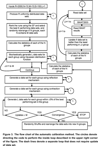
Research has established several concepts for automatic calibration of conceptual watershed models. The main concept is the competitiveness between the data sets where the best performing sets (according to selected objective function) are more likely to participate in forming new sets. Hence, probability distribution functions are usually used to define the best and worst performing sets with the highest and lowest probability values, respectively (Wang, Citation1991). Duan et al. (Citation1992) added the concept of complex shuffling (SCE) that allows independent optimization of several data set groups, and sharing of information between the groups by periodic shuffling of the groups. The SCE procedure generates new data sets after each shuffle and completely replaces the current data sets but keeps the best performing data set. Tolson and Shoemaker (Citation2007) used the concept of competitive enhancement through a normal distribution probability function instead of the linear probability function used by Wang (Citation1991) and the trapezoidal function used by Duan et al. (Citation1992). Furthermore, Tolson and Shoemaker (Citation2007) applied a greedy type of algorithm, in which a solution is never updated by an inferior solution in terms of the objective function, with the overall object of reaching a range of possible solutions instead of searching for an optimal set of calibrated inputs as in the case of the SCE method. Gupta and Sorooshian (Citation1983) pointed out that the uncertainty of the calibrated parameters due to the inherent model deficiencies, and the nonlinearity and interdependence between model parameters prevents the automatic calibration techniques from finding a unique set of calibrated inputs. Our goal from the automatic calibration was to describe calibrated parameter values within a bracket of uncertainty, e.g., a 95% confidence interval. However we favored two of the principle ideas used in SCE method, namely, independent enhancements among several parameter groups, and periodically shuffling and rearranging the groups. Therefore we developed an automatic calibration that method consisted of two stages. In the first stage the calibrated parameters were assumed to have a uniform distribution, and 2000 sets of inputs randomly generated. An equal weighting was given to each year in the calibration record by calculating a Nash-Sutcliffe efficiency coefficient (EF) for each year and then ranking the sets from highest to lowest according to the average EF.
The top 100 sets were then selected and randomly distributed into 10 groups, each containing 10 sets of input data. Then a separate Gaussian distribution probability function was calculated for each parameter in every group, by assuming the parameters of best performing set to be mean values and calculating the parameter variances using all the parameter sets in the group. In the second stage, three steps were used to enhance the calibrated input values:
Step 1: Stochastically generating new sets of input parameters using the Gaussian PDF.
Step 2: Controlled searching using the following two methods as described by Duan et al. (1992) and Price and Dixon (Citation1983):
a. Reflection:
b. Contraction:
Step 3: Randomly generating new sets of input within 5% of the parameters of the best performing data set.
The automatic calibration () is repeated within a loop as specified by the user or until a satisfactory solution is reached. Within each loop, the user can specify the number of repetitions for steps 1 and 3. For the calibration of the LLB watershed, the looping through steps 1 to 3 continued until there was no significant improvement in the Nash-Sutcliffe function, or when it becomes clear that better performing data sets were infrequently produced. Within each loop, step 1 was repeated 10 times, and step 3 was performed once for each group or repeated until at least 10 better performing data sets were produced for all groups.
Figure 3. The flow chart of the automatic calibration method. The circles denote directing the code to perform the inside loop described in the upper right corner of the figure. The dash lines denote a separate loop that does not require update of data set.
Our automatic calibration method is similar to the SCE in that both methods include independent optimization of separate groups of inputs combined with periodical shuffling between the groups. Also similar to the SCE we incorporated the reflection (EquationEq. 4) and contraction (EquationEq. 5
) as enhancement mechanisms. Our method includes several characteristics that differentiate it from the SCE. These are: (1) the initial input data sets are elected from a larger group of randomly generated data sets. The importance of the step is to eliminate unsuccessful input combinations and produce input data sets that have better odds of converging to the appropriate input ranges, (2) a data set can only be replaced by a better data sets, (3) the use Gaussian distribution instead of trapezoidal distribution, and (4) the goal is to find the appropriate distribution of input variables and not seeking an optimal set of input variables.
Our newly developed automatic calibration method showed consistency in converging to the same distribution when the calibration procedure was repeated for the same output data. This shows the model reliability in narrowing down to the global solution since; hypothetically, there are many local optima and one global optimal solution (Duan et al., Citation1992). Additional verification tests included the calibration of hypothetical SWAT output produced from known data sets. These tests showed the method ability to narrow down and close on the hypothetically know set of input parameters.
Two Way Calibration-Validation
The two way calibration-validation included two SWAT scenarios. Scenario 1 included calibration on 2004 and 2005 data and validation on 2006 and 2007 data. The reverse calibration-validation was used for scenario 2, i.e., 2006 and 2007 data were used for the calibration and 2004 and 2005 data for the validation. In addition a third scenario (scenario 3) included calibration on 2004, 2005 and 2006 data and validation on 2007 data ().
Statistics of the Input and Output Parameters
The SWAT parameters calibrated by the automatic procedure are defined by 100 data sets rather than a unique set of values. Therefore, SWAT input and output parameters were expressed in terms of means, variances and confidence intervals that in turn were weighted over the watershed area or the areas of the different types of crop cover or irrigation practices.
The weighted averages of SWAT parameters are calculated for each data set as:
where Pavg is the weighted average for a SWAT parameter, P L is a parameter defined on the watershed level, Arean is the nth HRU area, nHRU is the total number of the HRUs, Pn is a parameter defined on an HRU level, and Area T is the total area of the HRU(s) involved in the calculation.
Then, the mean, variance and confidence intervals are calculated using the 100 data sets:
Selection of SWAT Input Parameters for Calibration
We conducted a sensitivity analysis of the input variables by changing the value of one variable and keeping all other variables constants. An objective criterion to evaluate the model sensitivity was not used since only a few variables caused detectable changes in the model simulated streamflow.
The soil profiles were split into a surface layer (representing 30 cm of the upper soil profile) and a subsurface layer to minimize the number of calibrated parameters and to simplify the vertical heterogeneity within the soil profiles. The soil hydraulic conductivity (K sat ) was also included as a calibration parameter as a basic soil property. Therefore, including the surface and subsurface AWC and K sat , a total of 11 parameters were considered for the calibration process, and minimum and maximum values were assigned for each parameter ().
Table 3. The definition and range of values of the parameters used in SWAT calibration.
Results
Calibration and Validation
The model was most sensitive to the available soil water content (AWC) and curve number (CN2). Other sensitive parameters included the empirical coefficient related to recharge to and evaporation from the water table (). Changes in SURLAG, CH_N or K sat had no impact on the simulated streamflow.
The calibration and validation results for the three scenarios are shown in and . The calibrations of scenarios 1 and 3 were acceptable since the RMSE u was greater than RMSE s for both scenarios. Both scenarios satisfied the performance criteria by an EF of 0.51 for scenario 1 and an R 2 of 0.60 (0.03 and 0.86 for A and B respectively) for scenario 3.
Figure 4. Comparison between the simulated and observed monthly streamflow incremental differences.
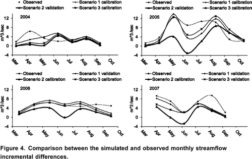
Table 4. The objective functions and statistical parameters for the calibration and validation of scenario 1, scenario 2 and scenario 3. The total observed net streamflows for 2004, 2005, 2006 and 2007 respectively.
The 2005 data resulted in a better correlation between the simulated and observed data for the calibration phase of scenarios 1 and 3. Adequate model performance for 2005 was indicated by the decomposition of the RMSE showing most of the error was unsystematic, thus the model replicated the main variations in the observed data. Adequate model performance was also indicated by an R 2 =0.61 combined with A and B values of 0.1 and 0.84 for scenario 1 and an EF of 0.6 for scenario 2.
The objective function criteria calculated separately for each season showed that the model calibration was not satisfactory for the years 2004, 2006 and 2007. The RMSE s outweighed the RMSE u for 2007 (scenario 2 calibration) and 2004 (scenario 3 calibration). The results of 2004 (EF=-0.39 and R 2 =0.05) for scenario 3 calibration and those of 2006 for scenario 2 (EF=-1.08 and R 2 =0.40) and 3 (EF=1.80 and R 2 = 0.37) calibrations were not satisfactory because of low EF and R 2 values.
The three scenarios underperformed in the validation phase. Unsatisfactory model validation was based on the fact the RMSE s values, calculated separately for each season and collectively for each validation period, were higher than RMSE u values.
The validation for scenario 3 for the 2007 was poor as indicated by EF and R 2 of 0.29 and 0.25, respectively, however it showed an improvement over scenario 1 validation on 2007, with an EF value of -1.73. It should be also noted that the validation results for a single year in the record characterized by low dynamics (observed values close to the mean of the observed data) may not be an accurate indicator of the model performance.
Shallow Aquifer Recharge and Discharge
The three scenarios were statistically different as indicated by average values and confidence intervals for the lumped ground water parameters (), namely, RCHRG_DP, REVAPMN, GW_DELAY, and GWQMN. The RCHRG_DP values of 0.61 and 0.06 for scenarios 1 and 2 respectively demonstrated the greatest differences between these two scenarios. For scenario 3 the RCHRG_DP was 0.53, i.e., leaning more toward scenario 1 than scenario 3, which indicates the influence of the high precipitation on scenarios 1 and 3. Scenario 1 calibrated values for REVAPMN, GW_DELAY, and GWQMN values were lower than those of scenarios 2 and 3. However, scenario 3 values were closer to those of scenario 1 than those of scenario 2. This parameterization was the result of the high precipitation in 2005 that generated appreciable ground water recharge GW_RCHG of 281.9 and 300 mm for scenarios 1 and 3, respectively (). The automatic calibration method allocated the major portion of the GW_RCHG to the deep aquifer to balance the simulated with the observed volume, while the GW_DELAY and GWQMN were dependent on the correspondence between the GW_Q and streamflow dynamics. The GW_Q for scenario 1 amounted to 33.3 and 98.8 mm for 2004 and 2005, respectively, and outweighed the runoff and return flow. The calibrated set of parameters for scenario 1 dampened the GW_Q values for the scenario 1 validation period of 2006 and 2007 (). Subsequently the incremental streamflow was underestimated and total simulated volume was reduced by half during the validation period.
Figure 5. The weighted averages of calibrated and the simulated daily ground water disch-arge and ground water recharge. The data of 2004 and 2005 were used for the calibration of scenario 1 and the verification of scenario 2. The data of 2006 and 2007 were used for the calibration of scenario 2 and the validation of scenario 1.
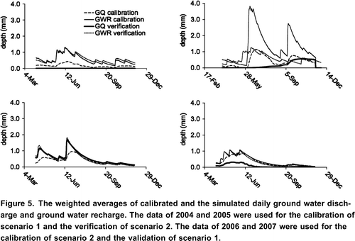
Table 5. Watershed weighted average calibrated input parameter, for scenario 1 (calibrated on 2004 and 2005 data), scenario 2 (calibrated on 2006 and 2007 data) and scenario 3 (calibrated on 2004, 2005, and 2006), and confidence intervals at probability level of at =0.05 (eq. 12).
Table 6. The weighted averages (mm) of the watershed output for scenario 1 (calibrated on 2004 and 2005 data), scenario 2 (calibrated on 2006 and 2007 data) and scenario 3 (calibrated on 2004, 2005, and 2006), and confidence intervals are calculated at probability level of at =0.05 (eq. 12).
For scenario 2 most of the GW_RCHG was retained in the shallow aquifer or discharged into the main reach when it reached the tipping point indicated by the GWQMN. Only 6% (RECHRG_DP=0.06) of the recharge was routed to the deep aquifer (), and generated an average of 88.0 and 66.9 mm in GW_Q for 2006 and 2007, respectively. The GW_Q and ground water recharge curves for 2006 and 2007 () supported the observed incremental streamflow record shown in .
Validation for scenario 2 on 2004 and 2005 data showed reduced net streamflow, which was similar to the response of the validation of scenario 1 on 2006 and 2007 data but for a different reason. The GW_RCHG contribution to the deep aquifer was only 6% for scenario 2; however, most of the GW_RCHG was retained in the shallow aquifer during 2004 and 2005 because the GWQMN of 510 mm was only met by August 2005 (). Thus, 2005 served as an equilibrium period for the scenario 2 calibration. The value of GWQMN was automatically adjusted relative to the wet conditions of 2005; similarly, a GWQMN value of 0.1 mm reflects the dry condition in 2003, preceding the calibration of scenario 1. It is evident from the automatic calibration of both scenarios that the storage in the shallow aquifer was sufficient to contribute continuously to the streamflow.
Scenario 3, on the other hand, included information from two dry (2004 and 2006) and a wet year (2005). The RECHRG_DP value of 0.53 still accommodated the water balance required for 2005 () and at the same time allowed a reduction in the percolation to the deep aquifer and a greater GW_Q. Calibration of scenario 2 on 2006 data resulted in 88.0 mm in GW_Q compared to 30.0 mm predicted by scenario 1. Scenario 3 calibration gave a value of 55.5 mm, but still not sufficient to simulate the increase in streamflow volume observed in 2006. Scenario 3 also predicted 23.0 mm as irrigation return flow, compared to 11.2 and 14.5 mm by scenarios 1 and 2, respectively. The rest of the deficit was spread over the simulation period and reflected as an underestimation below the scenario 2 calibration curve ().
Most of the GW_Q during 2004 occurred from mid May until the end of July (). In 2005 the ground water discharge peak during June () explains the increase in the observed incremental volume (). In 2006 the GW_Q rates were steady during April and May at approximately 0.5 mm/day, causing a steady increase followed by an abrupt increase in July to 1.0 mm/day, which lasted until the end of July. Most of the GW_Q for 2007 occurred during the beginning of the season associated with a gradual decrease toward the end of August, which was consistent with the high incremental streamflow volumes observed in May that started to decline during June and July.
Surface Water
The highest runoff amounts for 2005 were 29.3, 24.1 and 31.9 mm as predicted for scenarios 1, 2 and 3, respectively. For the other simulation years, the total runoff depth was between 1.1 to 6.2 mm (). These low runoff amounts were consistent with the incremental streamflow changes and absence of typical runoff peaks ().
Table 7. Generated runoff (mm) based on irrigation practice and crop cover. Confidence intervals are calculated at probability level of =0.05 (eq. 12). Comparison are indicated for runoff values simulated for each year separately Similar superscript letters denote statistical insignificance for comparison for irrigation practices, and roman number denote statistical insignificance for crop cover.
The watershed weighted CN2 values were similar for the three scenarios and within the 4042 range as defined by the confidence intervals (). The calibrated CN2 values were, as anticipated, larger for cereals than for forages (). The non-irrigated area average CN2 values were also lower than those for the irrigated areas.
Table 8. Calibrated input weighted averages based on the irrigation practice, and crop cover. Confidence intervals are calculated at probability level of =0.05 (eq. 12).
The runoff from forage planted areas was predicted with a wide margin of uncertainty (12.341.0 mm for 2005), but still considerably and statistically lower than from cereals (73.613.3 for 2005). Scenario 3 maintained a slightly higher runoff from cereals than forages, but the overlapping confidence interval suggested that differences between the different crop cover and irrigation practices groups were insignificant ().
Discussion
Calibration and Validation
The calibration was satisfactory for scenarios 1 and 3. The poor performances for the scenario 2 calibration and the validation of the scenarios as indicated by the EF values () were due to the fact that the observed average is a very good predictor owing to its closeness to the observed values (). However, the difficulty of outperforming the average as a predictor in such a case should not undervalue the importance of the model since it has the advantage of providing insights into the hydrological processes in the watershed, and information that can not be deduced from the average alone.
The comparison between the calibration and validation of scenario 1 and 3 demonstrated that the influence of 2005 data on the calibration results was greater than that of either 2004 or 2006 data, as indicated by the generally acceptable objective functions (e.g., EF 0.47 and R 2 >0.6) calculated for all years in the record. The objective functions calculated separately for each year were outside the range of acceptable values except for 2005. The only season with above average precipitation (2005) influenced the calibration process more than any other year in the record.
The earlier cited study of Chanasyk et al. (Citation2003) also showed an acceptable calibration of SWAT on a wet year but validation results on two dry years were unsatisfactory. Our findings were consistent with those of Van Liew et al. (Citation2007) where SWAT validation was noticeably better for a watershed characterized by high streamflows than watersheds characterized by low streamflows. Difficulties in achieving acceptable validation for low flow watershed in southern Alberta were also reported by Olson and Kalischuk (Citation2010).
Measurement uncertainties may also have contributed to the model underperformance. An inspection of showed that the 29% and 54% of the daily net streamflow is within 5 and 10, respectively, of the daily streamflow measured at the inlet station. Gupta et al. (Citation1998) recognized that the objective function measure the model error and the data measurement error without having a solid method to isolate both sources of error. Therefore, objective functions may not always reflect the full potential of the model.
A longer simulation (calibration or validation) record may produce better statistics, as also noted by Green and Van Grienvsan (Citation2008). However, the calibration and validation results of scenarios 1 and 3 on 2007 data indicated that a validation record similar in composition to the calibration record may be vital for obtaining an acceptable validation.
Shallow Aquifer Recharge and Discharge
The model results showed that ground water recharge peak occurred early in the growing season during May and June. This finding was consistent with results published from studies on surface and ground water interactions in southern Alberta. A long term monitoring of the water table levels in the Bow River Irrigation district (BRID) (Beke et al., Citation1993) showed that the greatest rises in the water table were observed during the period of May to August which mainly attributed to the downward movement of precipitation as the mean seasonal rainfall during this period constituted approximately 40% of mean annual precipitation. Rodvang et al. (Citation2004) also established that unconfined shallow ground water in southern Alberta is vulnerable to contamination by irrigation water. Furthermore, they suggested that ground water discharge can adversely affect the surface water quality. Ground water monitoring results on a farm with Lethbridge Northern Irrigation district showed evidence of local denitrification as a result of mixing between percolating water and deeper ground water (McCallum et al., Citation2008).
According to scenario 1 the maximum RCHRG_DP constituted an average of 61% of the total seepage outside the root zone. However a RCHRG_DP value of this magnitude is much higher than the anticipated deep aquifer percolation rates for southern Alberta (Rodvang et al., Citation2004). SWAT considers the amount of water entering the deep aquifer as lost or removed from the system not contributing to the water balance unless it was pumped from the deep aquifer and returned back to the system. Therefore, the calibration values of RCHRG_DP in scenario 1 may have also incorporated ground water discharge into the streamflow outside the watershed's main reach.
Surface Water
The calibrated CN2 values were lower than the considered A hydrologic soil group's typical range of 6065 for small grains and within the lower end of the 3968 CN2 range for pasture (Neitsch et al., Citation2002). Reduced CN2 values are not uncommon. Ndomba et al. (2008) used a calibrated CN2 value of 35. Lin and Radcliffe (Citation2006) started with default CN2 values of 69.7 for forest and 74.0 for grassland and pasture, but then reported lower calibrated CN2 values of 54.9 and 66.7 for forests and pasture, respectively. The calibrated CN2 values by Van Liew et al. (Citation2005) ranged from 30 to 42. They found that a CN2 of 37 for pasture improved the model fit but they attributed the reduction in CN2 values to a model deficiency in using this approach to adequately account for physical processes that occur in the precipitation runoff partitioning mechanism on the watershed.
However, in our case, the out-of-range values are justified on the basis of the empirical nature of CN2 values which represent the average conditions, and modifications were needed to reflect the specific conditions of the watershed, mainly, a flat landscape and high soil permeability. Rainfall simulator experiments in the watershed showed that runoff generation is sporadic and requires extreme rainfall intensities (Sturat et al., Citation2010)
Irrigated areas are expected to have a greater potential for runoff generation due to generally higher soil water contents at the soil surface. However, this effect may be countered by the fact that irrigated land can support denser vegetative covers, thus, reducing the runoff by combined effect of increased transpiration and canopy detention. The pasture and grass canopy can detain more precipitation than cereals and therefore enhance infiltration and reduce runoff.
However, the hydrological effects of land use and crop cover may not be fully manifested unless the calibration record was dominated by wet seasons as demonstrated from the results shown in . The model predicted runoff contribution from the cereal planted and irrigated areas, but with considerable uncertainty within the results of the three calibrated scenarios and within the results of each scenario. The runoff predicted by scenario 2 showed minor differences based on irrigation practice and crop cover; in contrast scenario 1 simulated runoff predominately from cereals and irrigated areas.
Conclusions
The SWAT model could be satisfactorily calibrated on this unique watershed for Scenarios 1 and 3 for the wet year (2005) or when this wet year was included with other years, but model validation was not satisfactory for these two scenarios. In contrast, the model could not be calibrated or validated for Scenario 2 (no wet year in calibration). Although we conclude that the SWAT model could not be successfully validated on this unique watershed, a longer period of record may result in successful validation. We conclude that the low runoff in this watershed and short period of record were the most likely cause of the unsatisfactory validation.
The influence of the wet season of 2005 on the calibration results outweighed the effect of at least two years of below average precipitation. Thus, the SWAT model is more suited for the simulation of the hydrological processes dominant during wet conditions than those observed during dry conditions. Therefore future enhancements to SWAT should consider the model's ability to perform under different combinations of wet and dry conditions. It is true that SWAT users can adjust for the climatic conditions through the vast number of input parameters. However, empirically adjusting the calibration process should not replace the need for future research to address the validity of conceptual models under varying climatic conditions, because available observed records may not represent all possible combinations of wet and dry periods preceding each other. For example, soil water percolating from the soil profile into the shallow ground water aquifer during wet years may affect the streamflow discharge for the following two or three years. Also the validity of conceptual model calibration using a mixed climatic record should be addressed with regard to the model's ability to predict drought and global warming effects on the hydrological cycle. Thus, future model enhancements of SWAT should be aimed at replacing some of the empirical method by procedures that can be parameterized by easily measured physical inputs.
According to the SWAT modeling results the ground water discharge from the shallow aquifer was a major contributor to the net streamflow; therefore, the simplified representation of ground water processes in SWAT may have contributed to modest model performance. The delineation in the SWAT model is based on surface water contribution and not ground water. Therefore, discrepancies in streamflow predictions, resulting in unsatisfactory model validation, can be also attributed to ground water contribution from outside the watershed unaccounted for in the model.
The effect of ground water discharge on the streamflow is a significant finding, however, it is realized only within the context of the model results; therefore, field investigations should be undertaken to test the validity of this finding. The modeling results can be improved in the future by developing the ground water component in SWAT or supplementing SWAT with a subsurface flow model.
Nomenclature
Acknowledgements
This study was made possible by funding from the Watershed Evaluation of Beneficial Management Practices program (WEBs) of Agriculture and Agri-Food Canada. We thank the Alberta Agriculture and Rural Development for providing the stream flow data and Dwayne Rogness of the County of Lethbridge for collecting the land use information from the producers in the watershed.
References
- Agricultural region of Alberta soil inventory database (AGRASID), Version 3.0. (http://www.agric.gov.ab.ca) (accessed: 14 June 2010.http://www.agric.gov.ab.ca
- Anand , S. , Mankin , K.R. , McVay , K.A. , Janssen , K.A. , Barnes , P.L. and Pierzynski , G.M. 2007 . Calibration and validation of ADAPT and SWAT for field-scale runoff prediction . Journal of the American Water Resources Association , 43 ( 4 ) : 899 – 910 .
- Arnold , J.G. , Srinivasan , R. , Muttiah , R.S. and Williams , J.R. 1998 . Large area hydrologic modeling and assessment part I: Model development . Journal of the American Water Resources Association , 34 ( 1 ) : 73 – 79 .
- Barber , V.A. , Juday , G.P. , Finney , B.P. and Wilmking , M. 2004 . Reconstruction of summer temperatures in interior Alaska from tree-ring proxies: evidence for changing synoptic climate regimes . Climate Change , 63 : 91 – 120 .
- Beke , G.J. , Entz , T. and Graham , D.P. 1993 . Aquifer characteristics and long-term ground-water levels . Journal of Irrigation and Drainage Engineering , 119 ( 1 ) : 129 – 141 .
- Bekele , E.G. and Nicklow , J.W. 2007 . Multi-objective automatic calibration of SWAT using NSGA-II . Journal of Hydrology , 341 : 165 – 176 .
- Bracmort , K.S , Arabi , M. , Frankenberger , J.R. , Engel , B.A. and Arnold , J.G. 2006 . Modeling long-term water quality impact of structural BMPs . Transaction of the American Society of Agricultural and Biological Engineering , 49 ( 2 ) : 367 – 374 .
- Cao , W. , Bowden , W.B. , Davie , T. and Fenemore , A. 2006 . Multi-variable and multi-site calibration and validation of SWAT in a large mountainous catchment with spatial variability . Hydrological Processes , 20 ( 5 ) : 1057 – 1073 .
- Chanasyk , D.S. , Mapfumo , E. and Wilms , W. 2003 . Quantification and simulation of surface runoff from fescue grassland watersheds . Agricultural Water Management , 59 ( 2 ) : 137 – 153 .
- Chu , T.W. and Shirmohammadi , A. 2004 . Evaluation of the SWAT model's hydrology component in the Piedmont physiographic region of Maryland . Transaction of the American Society of Agricultural Engineering , 47 : 1057 – 1073 .
- Chung , S.W. , Gasssman , P.W. , Gu , R. and Kanwar , R.S. 2002 . Evaluation of EPIC for assessing Tile flow and nitrogen losses for alternative agricultural management systems . Transaction of the American Society of Agricultural and Biological Engineering , 45 ( 4 ) : 1135 – 1146 .
- Deb , K. , Pratap , A. , Agarwal , S. and Meyarivan , T. 2002 . A fast and elitist multi-objective genetic algorithum: NSGA-II . IEEE Transactions on Evolutionary Compution. , 6 ( 2 ) : 182 – 197 .
- Deliberty , T.L. and Legates , D.R. 2003 . Interannual and seasonal variability of modeled soil moisture in Oklahoma . International Journal of Climatology. , 23 : 1057 – 1086 .
- Duan , Q. , Sorooshian , S. and Gupta , V. 1992 . Effective and efficient global optimization of conceptual rainfall-runoff models . Water Resources Research. , 28 ( 4 ) : 1015 – 1031 .
- Gan , T.Y. and Biftu , G.F. 1996 . Automatic calibration of conceptual rainfall-runoff models: Optimization algorithms, catchment conditions, and model structure . Water Resources Research , 32 ( 12 ) : 3513 – 3524 .
- Gassman , P.W. , Reyes , M.R. , Green , C.H. and Arnold , J.G. 2007 . The Soil and Water Assessment Tool: Historical development, applications, and future research directions . Transaction of the American Society of Agricultural and Biological Engineering , 50 ( 4 ) : 1211 – 1250 .
- Gitau , M.W. , Gburek , W.J. and Bishop , P.L. 2008 . Use of the SWAT model to quantify water quality effects of agricultural BMPs at the farm scale level . Transaction of the American Society of Agricultural and Biological Engineering , 49 ( 2 ) : 367 – 374 .
- Gollamudi , A. , Madramootoo , C.A. and Enright , P. 2007 . Water quality modeling of two agricultural fields in southern Quebec using SWAT . Transaction of the American Society of Agricultural and Biological Engineering , 50 ( 6 ) : 1973 – 1980 .
- Govender , M. and Everson , C.S. 2005 . Modelling streamflow from two small South African experimental catchments using the SWAT model . Hydrological Processes , 19 ( 3 ) : 683 – 692 .
- Green , C.H. and van Griensven , A. 2008 . Autocalibration in hydrologic modeling: Using SWAT2005 in small-scale watersheds . Environmental Modelling and Software , 23 : 422 – 434 .
- Gupta , K.V. and Sorooshian , S. 1983 . Uniqueness and observability of conceptual rainfall-runoff model parameters: The percolation process examined . Water Resources Research , 19 ( 1 ) : 269 – 276 .
- Gupta , H.V. , Sorooshian , S. and Yapo , P. O. 1998 . Toward improved calibration of hydrologic model: multiple and noncommensurable measures of information . Water Resources Research , 34 ( 4 ) : 751 – 763 .
- Klemes , V. 1986 . Operational testing of hydrological simulation models . Hydrological Sciences Journal , 31 : 13 – 24 .
- Krause , P. , Boyle , D.P. and Base , F. 2005 . Comparison of different efficiency criteria for hydrological model assessment . Advances in Geosciences , 5 : 89 – 97 .
- Legates , D.R. and McCabe, Jr , G.J. 1999 . Evaluating the use of goodness-of-fit measures in hydrologic and hydroclimatic model validation . Water Resources Research , 35 ( 1 ) : 233 – 241 .
- Lin , Z. and Radcliffe , D.E. 2006 . Automatic calibration and predictive uncertainty analysis of a semi distributed watershed model . Vadose Zone Journal , 5 : 248 – 260 .
- Mapfumo , E. , Chanasyk , D.S. and Willms , W.D. 2004 . Simulating daily soil water under foothills fescue grazing with the soil and water assessment tool model (Alberta, Canada) . Hydrological Processes: 2787 , 18 : 2800
- McCallum , J.E. , Ryan , M.C. , Mayer , B. and Rodvang , S.J. 2008 . Mixing-induced groundwater denitrification beneath a manured field in southern Alberta, Canada . Applied Geochemistry , 23 : 2146 – 2155 .
- Mekonnen , M.A , Worman , A. , Dargahi , B. and Gebeyehu , A. 2009 . Hydrological modeling or Ethiopian catchments using limited data . Hydrological Sciences Journal , (23):3401-3408
- Moriasi , D.N. , Arnold , J.G. , Van Liew , M.W. , Binger , R.L. , Harmel , R.D. and Veith , T. 2007 . Model evaluation guidelines for systematic quantification of accuracy in watershed simulations . Transaction of the American Society of Agricultural and Biological Engineering , 50 ( 3 ) : 885 – 900 .
- Muleta , M.K. and Nicklow , J.W. 2005 . Sensitivity and uncertainty analysis coupled with automatic calibration for a distributed watershed model . Journal of hydrology , 306 ( 2 ) : 127 – 145 .
- Narasimhan , B. , Srinivasan , R. , Arnold , J.G. and Di Luzio , M. 2005 . Estimation of long-term soil moisture using a distributed parameter hydrologic model and verification using remotely sensed data . Transaction of the American Society of Agricultural Engineering , 48 ( 3 ) : 1101 – 1113 .
- Nash , J.E. and Sutcliffe , J.V. 1970 . River flow forecasting through conceptual models part 1 A discussion of principles . Journal of hydrology , 10 ( 3 ) : 282 – 290 .
- Ndomba , P. , Mtalo , F. and Killingtveit , A. 2008 . SWAT model application in a data scarce tropical complex catchment in Tanzania . Physics and Chemistry of the Earth , 33 : 626 – 632 .
- Texas: Texas Water Resources Institute, College Station, 458 pp.
- Alberta Agriculture and Rural Development, Lethbridge, Alberta, Canada, 385 pp
- Patry , G.G. and Marino , M.A. 1983 . Nonlinear runoff modeling: parameter identification . Journal of Hydraulic Engineering , 109 ( 6 ) : 865 – 880 .
- Price , W.L. and Dixon , L.C.W. 1983 . Global optimization by controlled random search . Journal of Optimization Theory and Applications , 40 ( 3 ) : 333 – 348 .
- Qi , C. and Grunwald , S. 2005 . GIS-Based hydrologic modeling in the Sandusky watershed using SWAT . Transaction of the American Society of Agricultural Engineering , 48 ( 1 ) : 169 – 180 .
- Rodvang , S.J. , Mikalson , D.M. and Ryan , M.C. 2004 . Changes in ground water quality in an irrigated area in southern Alberta . Ground Water Quality , 33 : 476 – 487 .
- Santhi , C. , Arnold , J.G. , Williams , J.R. , Dugas , W.A. , Srinivasan , R. and Hauck , L.M. 2001a . Validation of the SWAT model on a large river basin with point and nonpoint sources . Journal of the American Water Resources Association , 37 ( 5 ) : 1169 – 1188 .
- Santhi , C. , Arnold , J.G. , Williams , J.R. , Hauck , L.M. and Dugas , W.A. 2001b . Application of a watershed model to evaluate management effects on point and nonpoint source pollution . Transaction of the American Society of Agricultural and Biological Engineering , 44 ( 6 ) : 1559 – 1570 .
- Singh , J. , Knapp , H.V. , Arnold , J.G. and Demisssie , M. 2005 . Hydrological modeling of the Iroquois River Watershed using HSPF and SWAT . Journal of the American Water Resources Association , 41 : 343 – 360 .
- Stewart , G.R. , Munster , C.L. , Vietor , D.M. , Arnold , J.G. , Macfarland , A.M.S. , White , R. and Provin , T. 2006 . Simulating water quality improvements in the upper north Bosque river watershed due to phosphorus export through turfgrass sod . Transaction of the American Society of Agricultural and Biological Engineering , 49 ( 2 ) : 357 – 366 .
- Ottawa: Agriculture and Agri-Food Canada, 142 pp
- Tolson , B.A. and Shoemaker , C.A. 2007 . Dynamically dimensioned search algorithm for computationally efficient watershed model calibration . Water Resources Research , 43 : 1 – 16 .
- Van Liew , M.W. , Arnold , J.G. and Bosch , D.D. 2005 . Problems and potential of autocalibrating a hydrologic model . Transaction of the American Society of Agricultural Engineering , 48 ( 3 ) : 1025 – 1040 .
- Van Liew , M.W. , Veith , T.L. , Bosch , D.D. and Arnold , J.G. 2007 . Suitability of SWAT for the conservation effects assessment project: Comparison on USDA agricultural research service watersheds . Journal of Hydraulic Engineering , 12 ( 2 ) : 173 – 189 .
- Wang , O.J. 1991 . The genetic algorithum and its application to calibrating conceptual rainfall-runoff models . Water Resources Research , 27 ( 9 ) : 2467 – 2471 .
- White , K.L. and Chaubey , I. 2005 . Sensitivity analysis, calibration and validations for a multisite and multivariable SWAT model . Journal of the American Water Resources Association , 41 ( 5 ) : 1077 – 1089 .
- Willmott , C.J , Ackleson , S.G. , Davis , R.E. , Feddema , J.J. , Klink , K. M. , Legates , D.R. , O'Donnel , J. and Rowe , C.M. 1985 . Statistics for the evaluation and comparison of models . Journal of Geophysical Research , 90 ( C5 ) : 8995 – 9005 .
- Willmott , C.J. 1982 . Some comments on the evaluation of model performance . Bulletin American Meteorological Society , 65 ( 11 ) : 1309 – 1317 .
- Wu , K. and Johnston , C.A. 2007 . Hydrologic response to climatic variability in a Great Lakes Watershed: A case study with the SWAT model . Journal of Hydrology , 337 ( 1,2 ) : 187 – 199 .
- Yang , Q. , Zhao , Z. , Chow , T.L. , Rees , H.W. , Bourque , C.P.A. and Meng , F. 2009 . Using GIS and a digital elevation model to assess the effectiveness of variable grade flow diversion terraces in reducing soil erosion in north-western New Brunswick, Canada . Hydrological Processes , 23 : 3271 – 3280 .
- Zhang , G.O. and Savenije , H.H.G. 2005 . Rainfall-runoff modeling in a catchment with a complex groundwater flow system: application of the representative elementary watershed (REW) approach . Hydrology and Earth System Sciences , 9 : 243 – 261 .