Abstract
In this paper the mean water year (October through September) flow of the North Saskatchewan River (NSR) at Edmonton, Alberta is reconstructed back to 1063 A.D. using a new network of moisture-sensitive tree-ring chronologies from limber pine and Douglas fir at seven sites in the headwater sub-basins of the North Saskatchewan River Basin (NSRB). Over the full extent of the proxy hydrometric record (10632007), we examined 1) the duration and severity of low flow, 2) the dominant frequencies of periodic variability and 3) the correlation between these significant periodicities in proxy streamflow and climate indices, specifically sea surface temperature oscillations, which are known drivers of regional hydroclimatic variability. This new record of the paleohydrology of the NSRB is compared to previous tree-ring reconstructions of the annul flow of the North and South Saskatchewan Rivers. Extending the reference hydrology for the basin from decades to centuries changes perceptions of the reliability of the water supply and understanding of the hydroclimatic variability. The gauge record not does represent the full extent of interannual to multidecadal variability in the tree-ring data; there are periods of low flow in the pre-instrumental record that are longer and more severe than those recorded by the gauge.
Dans la prsente communication, le dbit moyen de l'anne hydrologique (d'octobre septembre) de la riviare Saskatchewan Nord (RSN) Edmonton, en Alberta est reconstitu jusqu' 1063 de notre re l'aide d'un nouveau rseau de dendrochronologies sensibles l'humidit, grce au pin flexible et au douglas de Menzies, sept sites dans les sous-bassins du cours suprieur du bassin de la rivire Saskatchewan Nord (BRSN). Pour la dure complte des relevs hydromtriques indirects (de 1063 2007), nous avons examin 1) la dure et l'intensit des dbits d'tiage, 2) les frquences dominantes de la variabilit priodique et 3) la corrlation entre les priodicits importantes dans les indices climatiques et d'coulement fluvial substitutifs, plus particulirement les oscillations de temprature de surface de la mer, qui sont des facteurs connus de la variabilit hydroclimatique rgionale. Ce nouveau relev de la palohydrologie du BRSN est compar aux reconstitutions dendromtriques antrieures du dbit annuel des rivires Saskatchewan Nord et Sud. Le fait d'tendre l'hydrologie de rfrence pour le bassin d'une priode allant de dcennies des sicles change les perceptions de la fiabilit des rserves d'eau et la comprhension de la variabilit hydroclimatique. Le relev ne reprsente pas l'tendue complte des donnes dendromtriques de variabilit interannuelle multidcennale; certaines priodes de basses eaux dans le relev pr-instrumental sont plus longues et plus intenses que celles enregistres par la jauge.
Introduction
A growing demand for the surface water resources of the Canadian Prairie Provinces has resulted in increasing vulnerability to hydrological drought (Wheaton et al., Citation2008; Schindler and Donahue, Citation2006). This vulnerability will be intensified by further growth in the population and economy and by a warming climate (Barrow, Citation2010). A shift in the amount and timing of streamflow represents the most serious risk from recent and projected climate warming in western Canada (Sauchyn et al., Citation2010). Water resource management will be challenged by reduced mean flows in the summer season of peak demand, resulting from earlier spring snowmelt, declining contributions from glacier runoff, and a longer period of net evaporative water loss (Sauchyn et al., Citation2008).
The Saskatchewan River Basin is among Canada's most vulnerable watersheds, in terms of projected climate changes and impacts, and the sensitivity of natural systems and economic activities to Canada's most variable hydroclimate. The South Saskatchewan River (SSR) has been declared Canada's most threatened river (World Wildlife Fund, Citation2009). Whereas irrigation is the dominant use of water from the SSR (more than 70% of licensed withdrawals), most of the allocation from the North Saskatchewan River (NSR) is for industrial (83%) and municipal (8%) use (North Saskatchewan Watershed Alliance, Citation2007). The petroleum sector is allocated about 5% but is expected to account for most of the increase in withdrawals over the next 20 years (North Saskatchewan Watershed Alliance, Citation2007), largely for the processing of heavy oil at a series of new or expanded facilities in the Edmonton Industrial Heartland. This water use could be as high as about 10 times the current allocation for the city of Edmonton. The North Saskatchewan River Basin (NSRB; ) also is the potential location of a nuclear power generating station in west-central Saskatchewan. According to the proponent Bruce Power The operation of a nuclear facility also requires water for cooling. An assessment was conducted of all viable water sources in the province near sufficient infrastructure to support a facility. The North and South Saskatchewan Rivers were identified as viable water sources for a new nuclear plant in the province. (Bruce Power, Citation2008).
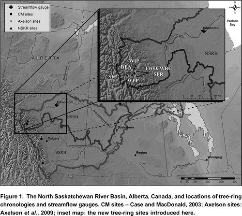
Figure 1. The North Saskatchewan River Basin, Alberta, Canada, and locations of tree-ring chronologies and streamflow gauges. CM sites Case and MacDonald, Citation2003; Axelson sites: Axelson et al., Citation2009; inset map: the new tree-ring sites introduced here.
This greater reliance on the North Saskatchewan River assumes a certain reliability of the source: mostly snowmelt and rainfall runoff from the Rocky Mountains. The average annual basin yield and interannual variability are known, at least if the gauge record is assumed to be stationary, that is, characterized by no systematic change in either mean or variance. This assumption of stationarity, a foundational concept that permeates training and practice in water-resource engineering (Milly et al., Citation2008), is undermined by observations from before the instrumental period and by projections of future hydroclimate. For example, in May 1796, when Edmonton House was a Hudson Bay Company post, the winter catch of furs could not be exported: there being no water in the [North Saskatchewan] river (Sauchyn et al., Citation2003), an extreme state that is outside the range of flows recorded by the gauge. Model projections of future water levels include significantly reduced summer flows (North Saskatchewan Watershed Alliance, Citation2008).
In this paper we present a 945-year reconstruction of the annual flow of the NSR derived from tree-rings collected at seven sites in the runoff generating upper basin. From this proxy hydrometric record, we determine 1) the frequency and duration of periods of sustained low flow over the past millennium, 2) the dominant modes of hydroclimatic variability, 3) the degree of correlation between these natural cycles and known drivers of regional hydroclimatic variability, and 4) whether the envelope of variability recorded by the gauge at Edmonton since 1912 is representative of the interannual to interdecadal variability captured by the tree rings since 1063.
The inference of hydroclimate from tree-ring proxies is a common approach to paleohydrology, the study of pre-instrumental water levels (Meko and Woodhouse, Citation2010). This application of dendrochronology has advanced in recent decades from inferring water levels from tree rings at one or a few sites to the modeling and analysis of hydroclimatic variability across networks of moisture-sensitive tree-ring chronologies. This progress is typified, for example, by the series of papers that document successively more robust reconstructions of the flow of the Colorado River (Woodhouse et al., Citation2006). Similarly, our work is preceded by a prior tree-ring reconstruction of the flow of the NSR, based on tree rings from one site in the basin and two sites from beyond the NSRB in southern Alberta near the Bow and Crowsnest Rivers (Case and Macdonald, Citation2003). The tree-ring chronology located in the basin spanned 1113 years but explained only 34% of the variance in the gauge record, an estimation of the naturalized flow at the Alberta Saskatchewan boundary. Introducing tree rings from outside the basin raised the explained variance to 49% but reduced the reconstructed length to 522 years (Case and Macdonald, Citation2003). Edwards et al. (Citation2008) used the Case and Macdonald (Citation2003) NSR reconstruction, combined with the isotope dendrochronology of some temperature-sensitive treeline sites in the Columbia Icefields area, to infer regional climatic and hydrologic variability over the past millennium. Our new tree-ring reconstruction, extending to 1063, is derived from tree rings from seven sites, all located in the upper NSRB. This improved streamflow reconstruction is the basis for an analysis of the long-term variability in the regional hydrologic regime.
Tree-Ring and Streamflow Data
A network of seven new tree-ring chronologies was established in the upper runoff-generating sub-basins of the NSRB (). At low to mid elevations in the Front Ranges of the Rocky Mountains, the montane forest includes open canopy stands of long-lived and moisture-sensitive coniferous trees. Limber pine (Pinus flexilis) grows at dry windy sites. They reach their northern limit in North America in the North Saskatchewan River valley. Douglas fir (Pseudotsuga menziesii) has a wider ecological amplitude that includes south to southwest facing slopes where soil moisture is limited. Both species are long lived, with 800-year-old limber pine and 700-year-old Douglas fir known to occur in western Alberta (Case and MacDonald, Citation2003; Watson and Luckman, Citation2006). During July 2008 and August 2009, we collected cores from living trees and cross sections of dead wood at the seven field sites ().
Table 1. Properties of tree-ring chronologies sampled in the North Saskatchewan River Basin, Alberta, Canada. Species code: PSME, Douglas fir (Pseudotsuga menziesii); PIFL, Limber pine (Pinus flexilis).
In the PARC Tree-Ring Lab at the University of Regina, high-resolution (1200+ dpi) images of sanded samples were captured using an Epson Expression 10000XL flatbed scanner. WinDendro Density (ver 2009b), a semi-automated image analysis system designed for tree rings, was used for visual and statistical crossdating of the tree-ring series and for measuring the annual growth increments to within 0.001 mm. The crossdating, which ensures that proper calendar years are assigned to each tree ring, was verified with the program COFECHA (Holmes, Citation1983). The program ARSTAN (Cook, Citation1985) was used to standardize the measured tree-ring series using conservative detrending methods: a negative exponential curve, which removes the juvenile biological growth trends in the tree-ring series; or a cubic smoothing spline, a low-pass digital filter with a 50% frequency response cutoff, the frequency at which 50% of the amplitude of the signal is retained (Cook et al., Citation1990). The standardized ring-width series of various lengths were averaged for each site, using a mean value function that minimizes the effect of outliers (Cook et al., Citation1990), producing dimensionless stationary index data with a defined mean of 1.0 and a relatively constant variance. In addition to this standard index chronology, ARSTAN produces a residual chronology by modeling and removing the first-order autocorrelation, and then an ARSTAN chronology by restoring the autocorrelation that is shared by the time series at a site (Cook, Citation1985). Site chronology statistics are given in . Record length ranges from 438 to 945 years. The coefficients of inter-series correlation and mean sensitivity indicate a strong common response to an external factor, very likely inter-annual variability in hydroclimate.
Naturalized weekly streamflow data for the North Saskatchewan River at Edmonton, AB were provided by Alberta Environment for the period 1912 2002. These naturalized flow data were derived from streamflow records, reservoir data, recorded and estimated irrigation withdrawals, and climate data using the Streamflow Synthesis and Reservoir Regulation (SSARR) model. The annual streamflow has a Gaussian frequency distribution according to a robust nonparametric Lilliefors test of normality. No significant autocorrelation was found in either the annual or water year streamflow records.
Streamflow Reconstructions
The tree-ring modeling of surface water levels is based on the principles and methods of dendrohydrology, which are well documented, for example by Loaiciga et al. (Citation1993) and Meko and Woodhouse (Citation2010). A consistent statistical relationship between mean (annual and seasonal) water levels and tree growth at dry sites is physically based on the direct link between the soil water balance and both rates of tree growth and watershed runoff. To ensure that our tree-ring width data from the NSRB are suitable predictors of streamflow, and to investigate the response of tree growth to seasonal climate, the standardized tree-ring chronologies were examined for the degree of correlation with monthly climatic and hydrometric data. Correlation coefficients were calculated between the residual index chronologies and mean monthly temperature and total monthly precipitation at Edmonton, Alberta (18802005), and between the standard, residual and ARSTAN chronologies and average monthly, annual and water year (OctoberSeptember) naturalized flow for the period 1912 to 2002. The results (not shown) include significant (p<0.05) correlations between the standard and residual tree-ring indices and summer and water year precipitation and streamflow for the current and previous year. Given the absence of significant autocorrelation in the annual flow series, the residual tree-ring chronologies were chosen as the potential predictors of water year flow.
A series of tree-ring models of average water year flow were constructed by forward stepwise regression. The pool of potential predictors consisted of the seven residual index chronologies for the growth year and at forward lags of one and two years. The lagged predictors account for an offset of up to two years between climate conditions in a given year and the response of tree growth and/or streamflow. The models were optimized according to a set of statistical measures of model quality and predictive capacity. The expressed population signal (EPS) is a ratio of signal to noise as a function of the correlation among trees at a site and sample depth. The length of the individual predictor chronologies was limited to the segment with an EPS 0.85, minimizing the inflation of variance associated with decreasing sample size (Briffa and Jones, Citation1990). Regression models of varying length were validated using a leave-n-out method, where observations are left out sequentially throughout the length of the streamflow record allowing maximum use of the data (Hughes et al., Citation1982). For the calibration period (19122006) the strength of the regression models was expressed using the adjusted R2, which quantifies the explanatory power of the regression while accounting for lost degrees of freedom with an increasing number of predictors (Fritts, Citation1976). For the verification period we used the reduction of error (RE) statistic, a rigorous measure of association between a series of actual values and their estimates. The theoretical limits of the RE range from a maximum of +1 to negative infinity. Any positive value indicates that the model has some predictive capacity (Fritts, Citation1976; Fritts et al., Citation1990). The F values for the regression models are a goodness-of-fit statistic. The standard error (SE) and root-mean-square error of validation (RMSEv) are measures of the uncertainty in predicted values over the calibration and validation periods, respectively. Regression residuals were tested for autocorrelation using the Durbin-Watson test (Ostrom, Citation1990). The mean variance inflation factor (VIF) was calculated to detect multicollinearity in the matrix of predictor values (Haan, Citation2002).
We were able to extend the annual hydrograph at Edmonton, Alberta, back to 1063 () by nesting a series of reconstructions of varying length (Meko, Citation1997). Calibration and verification statistics for the models indicate skillful reconstruction of the water year flow (). The models accounted for up to 46% of the instrumental variance and had significant skill when subjected to cross validation, according to consistently positive values of RE and significant (p<0.01) F statistics. In every case, the standard error and root-mean-square error of validation have similar magnitude and are relatively small (<20% of the reconstruction mean). The VIF values are near one, indicating little or no multicollinearity, with the exception of model 2, where a VIF of 4.6 indicates some inflation of the explained variance. The reconstruction replicates well the interannual variability in streamflow (), however, it is generally better at capturing the magnitude of the low flows, while underestimating the high flows throughout the calibration period. Underestimation of peak flows is a common limitation of tree-ring reconstructions; there is a biological limit to the response of tree growth to high precipitation and low evapotranspiration during wet years (Fritts, Citation1976).
Figure 2. Top: North Saskatchewan River observed and reconstructed water year (October to September) flow for the calibration period 19122006. Bottom: The full reconstruction of water year flow for the period 1063 2006. The adjusted R-squared values for the length of the reconstruction are shown along the bottom of the plot.
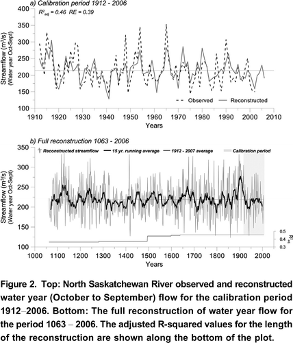
Table 2. Calibration and verification statistics for the tree-ring reconstruction models of water year flow. The predictand for each of the five models is water year (October to September) flow at Edmonton. The predictors, the tree-ring chronologies, are labeled using the codes from CitationTable 1 and CitationFigure 1. The subscripts indicates whether the tree-ring data are for the current year (0 lag) or lagged by 1 or 2 years.
Interpretation of Hydroclimatic Variability
Given the uncertainty in estimating streamflow from tree rings, and especially the high flows, our interpretation of the proxy hydrograph is based initially on a ranking of the annual flows and assigning them to percentile classes. The most severe droughts are defined as flows in the lowest 10th percentile. and show that our reconstruction, and the prior reconstructions for the North and South Saskatchewan Rivers (Case and MacDonald, Citation2003, and Axelson et al., Citation2009, respectively), have a similar sequence ( 1 or 2 years) of extreme single and multi-year droughts. Slight discrepancies between the NSRB and SSRB likely reflect differences in hydroclimate, such that the severity and timing of drought can differ between these large basins even though they are adjacent and both shed runoff from the Rocky Mountains. Discrepancies between the two NSR reconstructions, on the other hand, are attributable to different sets of predictor tree-ring chronologies. We argue the newer reconstruction presented here is more likely to represent the timing and severity of drought given that it is derived from a network of tree-ring chronologies that capture the drought signal at seven sites in the basin (versus one) and for two species (versus one).
Figure 3. Reconstructions of a) total annual streamflow of the North Saskatchewan River at the provincial boundary (Case and MacDonald, Citation2003), b) water year streamflow (October September) for of the South Saskatchewan River at Medicine Hat (Axelson et al., Citation2009), and c) water year flow of the NSR at Edmonton (from Figure 2). Reconstructions are smoothed with a 15-year running average.
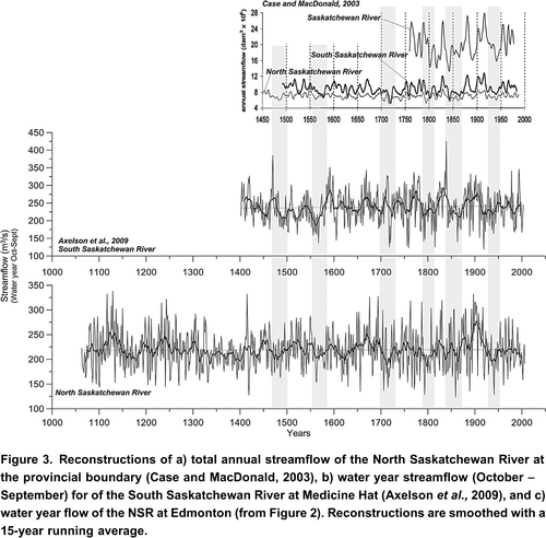
Table 3. Top 10 worst single year droughts for the North and South Saskatchewan River Basins, listed by descending severity. Underlined drought years occur in all the reconstructions (NSR 2010 this paper; NSR 2003-Case and MacDonald, Citation2003; Oldman and SSR-Axelson et al., 2009).
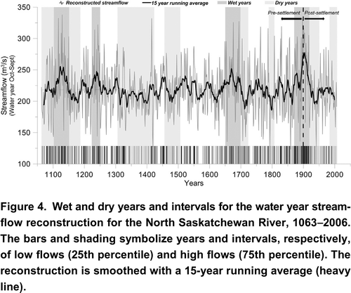
The lower frequency variability in hydroclimate can be characterized by the sequence of reconstructed flows in the 75th and 25th percentiles (wet and dry conditions, respectively; ). The most sustained wet period, or pluvial, in the entire proxy record, is during the late 19th century and early 20th century, when the Saskatchewan River basin was transformed by an influx of settlers. Whereas this best case scenario (i.e. in terms of consistently high water supply), occurred recently, the longest and most severe droughts pre-date Euro-Canadian settlement of the region. These multidecadal or mega droughts include about30 years in the early 1700s. This sustained drought also is recorded in a high-resolution pollen record from Lake Mina, Minnesota (St. Jacques et al., Citation2008) and a tree-ring record from southern Manitoba (St. George and Nielsen, Citation2002). Another30 year drought during the mid 1100s also appears in many other proxy records from central North America (Laird et al., Citation2003; Sridhar et al., Citation2006; Tian et al., Citation2006). The most prominent mega-droughts, lasting for most of the 14th century, and occurring again in the late 15th century, are the so-called Mississippian droughts, originating in the Mississippi Valley and extending northwest (to the NSRB), and eventually on a northeast tangent up into parts of eastern Canada (Szeicz and MacDonald, Citation1996; Stahle et al., Citation1998, Citation2000; Cook et al., Citation2007).
Figure 4. Wet and dry years and intervals for the water year streamflow reconstruction for the North Saskatchewan River, 10632006. The bars and shading symbolize years and intervals, respectively, of low flows (25th percentile) and high flows (75th percentile). The reconstruction is smoothed with a 15-year running average (heavy line).
The re-occurrence of low and high water levels at more or less regular intervals in suggests some quasi-cyclical behavior in the hydroclimatic regime of the past millennium. The main modes of periodic variability were identified using spectral analysis: the multitaper method (MTM) of Mann and Lees (Citation1996) and a continuous wavelet transform (CWT; Grinsted et al., Citation2004). The MTM is a powerful and widely used nonparametric method of spectral estimation providing high resolution while minimizing spectral leakage and reducing the variance of spectral estimates by using orthogonal tapers (Ghil, Citation2002). It is particularly well suited for short and noisy time series. With a frequency resolution suitable for resolving distinct climate signals, and improved spectral estimation properties over classical methods, the MTM has been widely applied to instrumental records of atmospheric and oceanic variables. We implemented MTM using the SSA-MTM Toolkit available at http://www.atmos.ucla.edu/tcd/ssa/. The CWT analysis is a powerful tool for the identification of non-stationary signals because it decomposes the time series into frequency components. Most traditional mathematical methods that examine periodicities in the frequency domain, such as Fourier analysis, have implicitly assumed that the underlying processes are stationary in time. Wavelet transforms expand time series into time frequency space and can therefore find localized intermittent periodicities (Grinsted et al., Citation2004).
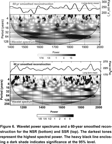
Results of the single-spectrum MTM analysis (, bottom) show a highly significant component of variability at interannual time scales in the El Nio-Southern Oscillation (ENSO) band (26 years). Various peaks in this frequency band extend above the 99% confidence level. Wavelet analysis (, bottom) mirrors the MTM spectrum, but with the additional context of the time domain. The dark shade (highest power) and black contours (statistical significance at p<0.05) indicate dominant modes of periodicity at high frequencies (28 years). There is also significant periodicity during 18th and 19th centuries at about 32 and 64 years. For comparison, Citation Figures 5 and Citation 6 include the MTM and Wavelet analyses of the Axelson et al. (Citation2009) SSR reconstruction. The strong interannual variability in the flow of the NSR and SSR conforms to the results of previous studies of sea surface temperature (SST) forcing, specifically ENSO, on the hydroclimate of western Canada (Shabbar and Skinner, Citation2004; Gobena and Gan, Citation2006). Lower frequency variability, reflecting the influence of the Pacific Decadal Oscillation (PDO; Gedalof and Smith, Citation2001; Gray et al., Citation2003) is evident in our NSR record but it accounts for a larger proportion of the variance in the SSR reconstruction (Axelson et al., Citation2009).
Figure 5. Results of the single-spectrum MTM analysis of the SSR (left) and NSR (right) reconstructions. The spectral peaks are labeled where they exceed the 99% confidence level.
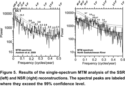
Figure 6. Wavelet power spectrums and a 60-year smoothed reconstruction for the NSR (bottom) and SSR (top). The darkest tones represent the highest spectral power. The heavy black line enclosing a dark shade indicates significance at the 95% level.
Conclusions
By developing a network of new moisture-sensitive tree-ring chronologies in the headwaters of the North Saskatchewan River, we were able to produce a robust reconstruction of streamflow since 1063. Our results are not directly comparable to previous studies of long-term hydrologic variability in the Saskatchewan River Basin (Case and MacDonald, Citation2003; Axelson et al., Citation2009), because we used somewhat different methods to create, calibrate, and validate the tree-ring models; however, the timing of severe low flow years and multidecadal mega-droughts are generally similar among the proxy records. They also are similar in terms of the amount of instrumental streamflow variance explained by the tree rings, about 50%, although according to other measures of model skill and validation and signal strength, our new reconstruction, based on tree-ring data from seven sites and two species, provides better estimation of the past annual flows than the prior reconstruction from tree-rings from one site in the watershed. Because much of the unexplained variance is related to the underestimation of high flows, we have more confidence in the interpretation of the low flows, which consistently correspond to narrow tree rings, capturing the timing and duration of drought. Spectral analyses provided evidence that streamflow variability in the upper NSRB is driven primarily by interannual oscillation patterns at 48 year frequencies (ENSO), rather than by multidecadal/low frequency forcing such as the PDO, which is more highly correlated with hydrometric records from southern Alberta (St. Jacques et al., Citation2010). However, oceanic-atmospheric circulation anomalies tend to influence hydroclimate at certain times of the year, so future work on the reconstruction of seasonal flow might produce different results in terms of the modes of variability in summer versus winter. This study of seasonal paleo-hydroclimate will require sub-annual tree-ring proxies, such as the width and density of the early- and late-wood components of the annual growth increment.
This 945-year reconstruction of the flow of the North Saskatchewan River provides an important context for water managers and policy makers. Research on the consequences of global warming for Canada's western interior suggests a shift in the distribution of runoff between seasons and years, such that there is an expanded range of hydroclimatic variability. These changes are all in relation to the known historical hydrology. If we assume stationarity, and that the historical record captures the envelope of natural variability, future departures from this recorded variability can be ascribed to the impacts of climate change. If we hypothesize, however, that the gauge record, despite its 98-year length, does not capture the full range of natural variability, then future extreme fluctuations partly represent natural variability that exceeds the range measured over the instrumental period. The study described here was able to address this hypothesis by comparing statistical properties, and specifically modes of variability, between the gauge record and a tree-ring reconstruction of the annual flow extending to 1063. The results indicate that the gauge record is comparable to the proxy record in terms of interannual variability, and the frequency of low flows. There is a significant discrepancy at lower frequencies, however, with proxy records displaying more and longer sustained departures from average flow. This interdecadal variability is associated with the most catastrophic climate event, prolonged drought. It also can lead to detection and interpretation of transient streamflow trends, especially in gauge records that are only decades in length. This study demonstrated that expanding the reference hydrology from a century to a millennium changes our understanding of the variability and consistency of water supplies. This longer perspective suggests that there is less certainty and stationarity in western water supplies than implied by the instrumental record, the conventional basis for water resource management and planning.
Acknowledgements
This research was funded by EPCOR Water Services Inc., the Natural Sciences and Engineering Research Council and the Prairie Adaptation Research Collaborative. For field and lab assistance, we thank Jonathan Barichivich, Michael Felgate, Sarah Ludlow, Golden Gooding, Nataliia Prytula, and Jeannine St. Jacques. We extend a further thank you to Dr. Scott St. George for suggestions and help in the field. Naturalized streamflow data were provided by Alberta Environment.s
References
- Axelson , J. , Sauchyn , D. and Barichivich , J. 2009 . New reconstructions of streamflow variability in the South Saskatchewan River Basin from a network of tree ring chronologies, Alberta, Canada . Water Resources Research ,
- Chapter 4 in
- Report on Bruce Power's Feasibility Study
- Case , R. and MacDonald , G. 2003 . Tree ring reconstructions of streamflow for three Canadian prairie rivers . Journal of the American Water Resources Association , 39 : 703 – 716 .
- 171 pp.
- Cook , E. , Seager , R. , Cane , M. and Stahle , D. 2007 . North American drought: Reconstructions, causes and consequences . Earth-Science Reviews , 81 : 93 – 134 .
- Edwards , T.W.D. , Birks , S.J. , Luckman , B.H. and Macdonald , G.M. 2008 . Climatic and hydrologic variability during the past millennium in the eastern Rocky Mountains and northern Great Plains of western Canada . Quaternary Research , 70 : 188 – 197 .
- Gedalof , Z. and Smith , D. 2001 . Interdecadal climate variability and regime scale shifts in Pacific North America . Geophysical Research Letters , 28 : 1515 – 1518 .
- Ghil , M. 2002 . Advanced spectral methods for climatic time series . Reviews of Geophysics , 40 : 41 1003
- Gobena , A. and Gan , T. 2006 . Low-frequency variability in southwestern Canadian streamflow: Links with large-scale climate anomalies . International Journal of Climatology , 26 : 1843 – 1869 .
- Gray , S. , Betancourt , J. , Fastie , C. and Jackson , S. 2003 . Patterns and sources of multidecadal oscillations in drought-sensitive tree-ring records from the central and southern Rocky Mountains . Geophysical Research Letters , 30
- Grinsted , A. , Moore , J. and Jevrejeva , S. 2004 . Application of the cross wavelet tranform and wavelet coherence to geophysical time series . Nonlinear Processes in Geophysiology , 11 : 561 – 566 .
- 2nd ed
- Holmes , R. 1983 . Computer-assisted quality control in tree-ring dating and measurement . Tree Ring Bulletin , 44 : 69 – 75 .
- Loaiciga , H.A. , Haston , L. and Michaelsen , J. 1993 . Dendrohydrology and long-term hydrologic phenomena . Reviews of Geophysics , 31 : 151 – 171 .
- Laird , K.R. , Cumming , B.F. , Wunsam , S. , Rusak , J.A. , Oglesby , R.J. , Fritz , S.C. and Leavitt , P.R. 2003 . Lake sediments record large-scale shifts in moisture regimes across the northern prairies of North America during the past two millennia . Proceedings of National Academy of Sciences , 100 : 2483 – 2488 .
- Mann , M.E. and Lees , J.M. 1996 . Robust estimation of background noise and signal detection in climatic time series . Climate Change , 33 : 409 – 445 .
- Meko , D. M. 1997 . Dendroclimatic reconstruction with time varying subsets of tree indices . Journal of Climate , 10 : 687 – 696 .
- Milly , P. C. D. , Betancourt , J. , Falkenmark , M. , Hirsch , R.M. , Kundzewicz , Z.W. , Lettenmaier , D.P. and Stouffer , R.J. 2008 . Climate change: stationarity is dead: whither water management . Science , 319 : 573 – 574 .
- 30 pp.
- 57 pp.
- 96 pp.
- Sauchyn , D.J. , Stroich , J. and Beriault , A. 2003 . A paleoclimatic context for the drought of 1999-2001 in the northern Great Plains . The Geographical Journal , 169 : 158 – 167 .
- 400 pp.
- Chapter 3 in
- Shabbar , A. and Skinner , W. 2004 . Summer drought patterns in Canada and the relationship to global sea surface temperatures . Journal of Climatology , 17 : 2866 – 2880 .
- Schindler , D.W. and Donahue , W.F. 2006 . An impending water crisis in Canada's western prairie provinces . Proceedings of the National Academy of Sciences , 103 : 7210 – 7216 .
- Sridhar , V. , Loope , D.B. , Swinehart , J.B. , Mason , J.A. , Oglesby , R.J. and Rowe , C.M. 2006 . Large wind shift on the Great Plains during the Medieval Warm Period . Science , 313 : 345 – 347 .
- Stahle , D. , Cleaveland , M. , Blanton , D. , Therell , M. and Gay , D. 1998 . The lost ecology and Jamestown droughts . Science , 280 : 564 – 567 .
- Stahle , D. , Cook , E. , Cleaveland , M. , Therrel , M. , Meko , D. , Grissino-Mayer , H. , Watson , E. and Luckman , B. 2000 . Tree-ring data document 16th century megadrought over North America . Eos , 81 : 12, 121
- St. George , S. and Nielsen , E. 2002 . Hydroclimatic change in southern Manitoba since A.D. 1409 inferred from tree rings . Quaternary Research , 58 : 103 – 111 .
- St. Jacques , J.M. , Cumming , B.F. and Smol , J.P. 2008 . A 900-year pollen-inferred temperature and effective moisture record from varved Lake Mina, west-central Minnesota, USA . Quaternary Science Review , 27 : 781 – 796 .
- St. Jacques , J.M. , Sauchyn , D.J. and Zhao , Yang . 2010 . Northern Rocky Mountain streamflow records: Global warming trends, human impacts or natural variability? . Geophysical Research Letters , 37 : L06407
- Szeicz , J. and MacDonald , G. 1996 . A 930-year ring-width chronology from moisture-sensitive white spruce (Picea glauca Moench) in northwestern Canada . Holocene , 6 : 345 – 351 .
- Tian , J. , Yang , Q. , Liang , X. , Xie , L. , Hu , D. , Wang , F. and Qu , T. 2006 . Observation of Luzon Strait transport . Geophysical Research Letters , 33 : L19607
- Watson , E. and Luckman , B.H. 2006 . Long hydroclimate records from tree-rings in western Canada: Potential problems and prospects . Canadian Water Resources Journal , 31 ( 4 ) : 205 – 228 .
- Wheaton , E. , Kulshreshtha , S. , Wittrock , V. and Koshida , G. 2008 . Dry times: hard lessons from the Canadian drought of 2001 and 2002 . Canadian Geographer , 52 : 241 – 262 .
- Woodhouse , C.A. , Gray , S.T. and Meko , D.M. 2006 . Updated streamflow reconstructions for the Upper Colorado River basin . Water Resources Research , 42 ( 5 ) : W05415