Abstract
An increased understanding of regional surface water quality and the key factors which differentiate regional from local differences is necessary for monitoring impacts such as mountain pine beetle infestation and related land management practices. This study develops a framework to identify water quality indicators which differentiate parameters influenced by rock type, by relatively short term anthropogenic activities, and those resulting from longer term climatic variability. Rock type was an overriding factor related to stream water chemistry in this British Columbia case study; with differences between watersheds differentiated by Ca, EC, Al and Fe. Grouping watersheds by their dominant rock type permitted the investigation of water quality with other watershed characteristics. The % forest cover, % pine cover, and dominant runoff processes demonstrated significant relationships with soluble cations, metals, turbidity and total organic carbon. Turbidity levels showed low variability, and relationships with mountain pine beetle were not strong; suggesting the need for more detailed data sets, selective monitoring of storm events, and longer term monitoring to improve predictive capacity.
Une meilleure connaissance de la qualit des eaux de surface rgionales et des facteurs qui la distingue des eaux de surface locales est ncessaire pour mieux discerner les impacts associs aux perturbations causes par lpidemie de dendrocthone du pin. Cette tude a pour but d'identifier les diffrents indicateurs de la qualit de l'eau qui sont influencs par la gologie du terrain et les activits anthropogniques de courte dure de ceux influencs par les variations du climat long terme. Dans le cas tudi, la gologie des bassins versants s'est avr tre un facteur dterminant en ce qui a trait aux proprits chimiques de l'eau de ruissellement, avec des variations entre les diffrents bassins versants pour Ca, EC, Al et Fe. Le groupment des bassins versants selon leur type de gologie a permis d'analyser l'effet des autres caractristiques des bassins versants sur la qualit de l'eau. Le pourcentage du couvert forestier, le pourcentage du couvert en pin et les processus de ruissellement montrent une corrlation significative avec les cations solubles, les mtaux, la turbidit et le carbone organique total. Les rsultats montrent un faible niveau de variabilit pour le niveau de turbidit. Celui-ci possde une faible corrlation avec la perturbation cause par lpidmie de dendrochtone du pin, suggrant le besoin pour des donnes plus dtailles, pour un suivi plus troit des vnements de crus et pour l'implantation d'un systme de suivi long terme, et ce afin d'amliorer notre capacit de prvision.
Introduction
Water resources management has become an increasingly important concern as human activity and climate change become recognized as major actors in influencing how we approach water resources conservation and management. Informed decisions on water resources management and how water resources may change under different conditions require an understanding of the relative roles of environmental factors and anthropogenic impacts. This is particularly challenging in regions such as British Columbia which are geographically diverse, experience flashy hydrological regimes, and where a large number of small to mid-size communities are reliant on surface water for drinking water supplies.
In general, it is recognized that natural water quality is controlled to a large extent by the geology of the drainage basin; this control is further affected by land use activities within the basin, as well as natural disasters such as wildfires and pest infestations which vary in relation to influences of climate. From a management perspective, some controlling factors can be managed while others cannot. Thus, from this standpoint it is necessary to have a framework that allows the identification of those water quality parameters that are natural (e.g., geological substrate), those influenced dominantly by relatively short term anthropogenic activities, and those resulting from longer term climatic variability.
This study focuses on the Cordilleran region of the Pacific Northwest, specifically the province of British Columbia (BC), Canada. This region is characterized by complex geology and high relief, variable climate in terms of precipitation and temperature, diverse forest and mining activities, a range of size of communities, impacts of natural wildfires and, more recently, an infestation of mountain pine beetle which has eliminated large areas of pine forests. The monitoring of impacts such as mountain pine beetle and related land management practices requires an increased understanding of regional surface water quality and the key factors that differentiate regional from local differences in water chemistry. This study develops an approach to assess the components that result in cumulative impacts and makes suggestions on how managers and decision makers might develop monitoring strategies congruent with the concerns of watershed management.
Simpson et al. (Citation1993) indicated that bedrock geology and mineralization were the most important variables influencing surface water chemistry in North Wales (1,279 sample sites), and that the primary control by geologic parameters (e.g., rock type) was variably modified by secondary influences including climate and land use. In contrast, Robson and Neal (Citation1997), using 20 years of data at over 200 sites in the eastern United Kingdom, found spatial trends in water quality associated with point versus diffuse sources, specifically domestic/industrial discharges versus metals associated with regions of extensive mineralization. Robertson and Saad (Citation2003) found that the percentage of forest or agriculture was the primary factor related to nutrient and sediment concentrations in 234 streams in the upper mid-west of the United States, but that surficial deposits were statistically related when land use was excluded. They proposed utilizing a regionalization scheme based on the environmental characteristics most statistically related to individual water quality parameters. However, Reimann et al. (Citation2009) and Banks et al. (Citation2001) suggested that changes in water chemistry due to anthropogenic impacts in Norway were hard to detect against the larger scale changes in natural background, with lithology being a major factor in the variation of inland water chemistry. A regional survey approach combined with site specific surveys was proposed to capture both the natural variation of chemical element concentrations and anthropogenic additions occurring at the local scale (Reimann and Garret, Citation2005).
In headwater catchments, streams have a strong linkage to the adjacent landscape through overland and shallow sub-surface flow paths (Kreutzweiser et al., Citation2008). Surficial geology and topography have a strong influence on the connectivity between upland soils and receiving waters (Buttle et al., Citation2005; Quinn et al., Citation1991), while vegetation composition can influence soil water nutrient concentrations (Hazlett et al., Citation2008). Forested headwater catchments constitute important drinking water supply sources for many communities in BC, and disturbances by forest management, fire or insect outbreak can disrupt natural biogeochemical processes and/or pathways to receiving waters (Kreutzweiser et al., Citation2008; Buttle et al., Citation2005), ultimately impacting water quality. However, comparison of water chemistry on the regional scale includes the influences of both geology and land use.
Within Canada, Spence et al. (Citation2009) suggested that the lack of databases at multiple space and time scales is a key gap in watershed management and in our understanding of how water resources may change under different conditions. A stratified water monitoring network of dependent and driving factors, and their inter-relationships, is proposed to improve our understanding of the geophysical processes (Hamilton and Whitfield, Citation2008). The objective of this research is to compare water chemistry across a range of third order community watersheds in south-central BC in order to identify indicators which differentiate geological and land cover differences, and thus permit a relative comparison of water quality within and between watersheds.
Approach and Case Study Watersheds
Stream water quality was monitored for 15 forest dominated watersheds in BC over a one year seasonal cycle in 2008 and compared to watershed characteristics. Key criteria for the selection of watersheds were: third order streams, community water supply watersheds, local partner participation and mountain pine beetle infestation (recent or historic). Fifteen watersheds were selected () and 12 partner organizations () participated in the research. A standard sampling protocol for water quality sampling was designed, and all water samples were collected and stored (frozen) by local partners for subsequent analysis. Samples were collected weekly during the freshet (AprilJune) and monthly throughout the summer and fall period (JuneOctober); bimonthly samples were taken in Fishtrap Creek in summer/fall as part of an ongoing research project at this particular site.
Figure 1. Location of participating watersheds.
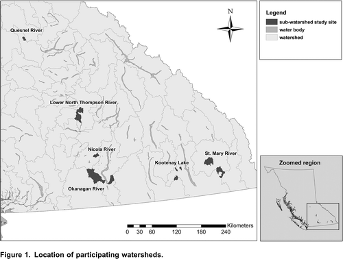
Table 1. Study regions, watersheds and watershed partners.
Water samples (n =206) were analyzed for: nutrients using Flow Injection Analysis (FIA-Lachat), turbidity using a Hach 2100P Turbidimeter, electrical conductivity (EC) using a WTW conductivity meter, metals and Si with an ICP-OES (Inductively Coupled Plasma Optical Emission Spectroscopy) and total organic carbon (TOC) using the persulfate method with a Phoenix 8000 TOC analyzer.
Watershed Characteristics
Watershed boundaries were defined by the 1:20,000 BC Watershed Atlas (GeoBC, Citation2003) for third order watersheds. Topographic characteristics were defined from a seamless 25 m Digital Elevation Model (DEM) derived from Terrain Resource Information Mapping (TRIM) elevation points and breaklines (Rosin and Weiler, Citation2006). Land use and land cover information was based on a combination of the 1:250,000 Baseline Thematic Mapping (BTM) (GeoBC, Citation1995) and the Vegetation Resources Inventory (VRI) (BC Ministry of Forests and Range (BCMFR), Citation2004). Geological information (dominant rock type) at 1:250,000 was obtained from the digital regional compilation of the geology of BC (Geological Survey Branch (GSB), Citation2005) and field evaluations. Mountain pine beetle infestation data for 1999 to 2008 were obtained from the forest health inventory (BCMFR, 2008). The dominant runoff processes (DRP) in the watersheds were determined by Rosin and Weiler (Citation2006), Weiler et al. (Citation2009) and Rosin (Citation2010) using a topographically based model. The DRPs calculated include channel interception, Hortonian overland flow (HOF), saturated overland flow (SOF), shallow sub-surface flow (SSF), and the area not dominant to runoff contribution.
Results and Discussion
Seasonal and Spatial Trends
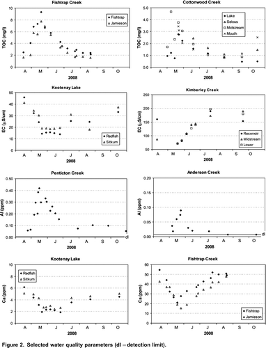
Water quality varies not only between watersheds but seasonally within a given watershed (). Total organic carbon (TOC) and turbidity show significant increases during spring freshet and decline during the summer low flow period, while EC, Ca, Mg and K behave similarly, declining during the freshet and becoming more concentrated during the summer low flow period, as lower flows translate to less dilution of soluble minerals and salts. Fe and Al behave similarly and opposite to the soluble salts, as expected. NOx, which is a mobile nutrient, generally decreases into late summer, related to biological activity, but values are low. EC varies significantly between regions reflecting geological differences (as discussed below), with the lowest EC values found in Redfish, Sitkum and Penticton Creeks; and higher EC in the Quesnel tributaries, Joseph, Fishtrap and Jamieson Creeks. The water chemistry results shown in represent general trends found in the data, and illustrate the range in water quality parameters found between watersheds (e.g., EC = 15 S/cm in Kootenay Lake versus 200 S/cm in Kimberley Creek).
Figure 2. Selected water quality parameters (dl=detection limit).
Correlations between water quality parameters separate into two distinct groups (). Turbidity, EC and soluble minerals and salts; and less soluble minerals and TOC; with Al and Ca negatively correlated. A comparative ranking of watersheds based on selective water quality parameters () indicates the range or lack of range in some parameters between watersheds, and suggests that watersheds can be grouped based on water quality. Turbidity, NOx and PO4 show limited variability between watersheds, but TOC, pH, EC, Ca and Fe show sufficient range to cluster watersheds into groups of similar chemistry. Watersheds were grouped into three classes based on the frequency distribution and significant differences in five water quality parameters: specifically TOC, pH, EC, Ca and Fe (; shading indicates watershed classes).
Figure 3. Correlations between water quality parameters (Spearman r, =0.01).
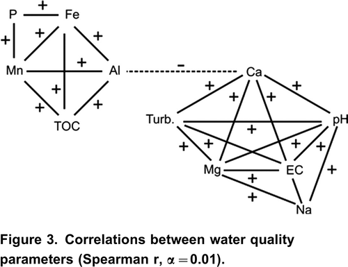
Table 2. Comparative rankings of selective water quality parameters by watershed (H=high, M=moderate, L=low). Shading relates to watershed classes.
Water quality relationships during both the freshet peak and summer low flow period show similar trends to the overall annual database. Correlations between parameters show the same two clusters: soluble salts and minerals, and less soluble minerals with TOC. Seasonal correlation coefficients are somewhat weaker compared to annual, but display the same trends. Lower Spearman rank correlation coefficients (r-values) may be a reflection of the smaller sample size when analyzing freshet or low flow data independently.
Watershed Characteristics
Watershed characteristics fall into three main categories: physical characteristics, geology, and land use/land cover ( to ). The watersheds range in area from 541 ha to >50,000 ha (Upper Trout Creek). Elevation range (max-min) was used to compare watersheds. Weiler et al. (Citation2009) classified the dominant runoff processes in the watersheds. Saturated overland flow (SOF) and shallow sub-surface flow (SSF) display the largest variation between watersheds and were used to explore relationships with water quality.
Table 3. Watershed characteristics physical factors. Shading relates to watershed classes.
The dominant rock type in the watersheds is given in . Six of the watersheds are dominantly intrusive igneous rocks (granite-granodiorite); four watersheds are volcanic (basalt) igneous rocks; and five watersheds are dominantly sedimentary (either Si-dominated-argillite, greywacke/fine clastic, or carbonate-dominated). Watersheds were grouped by their dominant rock type for comparison with water quality. Streams flowing through watersheds comprised of granite-granodiorite, in general, display lower pH, lower EC, higher Si, and low nutrient content in comparison to streams flowing through watersheds comprised of volcanic or sedimentary rocks. Consequently, including rock type as a factor when comparing between watersheds is critical; this is explored in the following section.
Table 4. Dominant rock type (% of area).
The land use/land cover characteristics of the watersheds are provided in . Overall the watersheds have a high percentage of forest cover. The % pine, however, is variable between watersheds. Recent and historic mountain pine beetle infestation levels indicate watersheds where the infestation rate has increased (e.g., Beak), declined (e.g., Quesnel; ) or remained low and relatively constant (e.g., Mark Creek). Road density (km road per km2 watershed area), in principle, provides an indication of the level of forestry activity; however, road expansion is dynamic, particularly in high infestation watersheds, and the roads database does not reflect recent road construction. Relative rankings for land cover characteristics (% forest, % pine, % MPB) were used to group watersheds to explore relationships with water quality.
Figure 4. Quesnel watersheds: mountain pine beetle infestation 19992005.
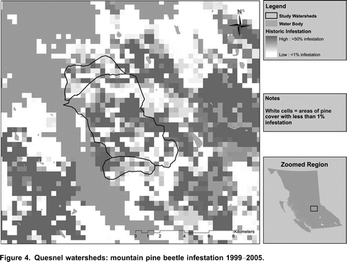
Table 5. Land use/land cover characteristics.
Water Quality Versus Watershed Characteristics
Correlations between watershed characteristics and selected water quality parameters are given in . As expected, the watersheds dominated by granitic rocks show low levels of soluble minerals and salts, and low turbidity (negative correlations). In contrast, watersheds dominated by sedimentary rock show higher pH, Mg and Ca content, although relationships are not as strong, likely due to their low sample numbers. This supports the understanding that dominant rock type in these watersheds plays a dominant role in influencing the water quality conditions.
Table 6. Correlations between water quality parameters (Spearman r, = 0.01).
Positive correlations were found between vegetation parameters and TOC; specifically % forest cover and % pine cover, with pine cover having a stronger relationship. TOC is not influenced by rock type, but reflects litter availability and decomposition. Surface overland flow (SOF) and shallow sub-surface flow (SSF) show opposing trends. High % SOF in a watershed relates to lower pH, Ca, EC and NOx, and higher TOC. The % SSF displays the opposite trends (although not all trends were statistically significant), suggesting that surface runoff does not interact significantly with the soil mediusm to generate soluble salts or NOx, but that organic matter at the surface plays an important role in release TOC.
Turbidity levels were of insufficient range to show the impact of land cover. Cumulative sediment monitoring (e.g., suspended sediment traps) would likely be required to relate watershed characteristics such as mountain pine beetle (MPB), road density and harvesting to stream sediment loads. The protocol developed by Carson et al. (Citation2008), relating sediment sources in close proximity with natural drainages to turbidity, is one approach which could be further explored in this regard.
The influence of rock type on water chemistry is highlighted in . Watersheds with intrusive rock types (granite-granodiorite) show higher levels of Al and Fe, lower pH, EC and Ca in comparison with streams flowing through volcanic or sedimentary rock types. Significant differences in water chemistry between the different rock types are shown in . Water quality indicators reflecting geology can be defined based on the parameters displaying significant differences between groups. Ca, EC, Na, and Mg, Fe, Al (to a lesser extent Cl) could be used to differentiate between intrusive, volcanic and sedimentary rocks, including carbonates.
Figure 5. Selected water quality parameters by geological group.
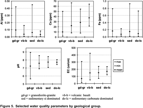
Table 7. Significant differences in water chemistry by rock type (Mann Whitney U-test, =0.10).
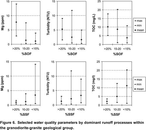
To separate the influence of geology on water chemistry, water quality parameters can be compared within a specific dominant rock type. For this analysis the granodiorite-granite group was assessed in greater detail (8 watersheds; n=70); other rock groups were not analyzed due to their low sample numbers. Water quality parameters in this sub-group of watersheds were then compared for the dominant runoff processes and the % pine based on the relationships highlighted in . Comparing dominant runoff processes within watersheds of the granodiorite-granite group indicates relationships between SOF and SSF with turbidity, TOC and soluble minerals (). As the percentage of area dominated by surface overland flow (SOF) increases in a watershed, the Mg, turbidity and TOC in the stream increase, as these parameters are transported by the flowing water. The opposite trends are found with shallow sub-surface flow (SSF).
Figure 6. Selected water quality parameters by dominant runoff processes within the granodiorite-granite geological group.
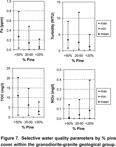
Comparing vegetation characteristics, specifically % pine cover within the watersheds of the granodiorite-granite group () indicates higher Fe, turbidity and TOC associated with increased watershed area under pine cover. Higher TOC levels are likely related to increased litter. Lower NOx in streams of high pine cover may reflect higher N uptake and more NOx release post harvesting, although overall NOx levels are low. No significant trends were found with either historic (19992005) or recent (20062008) mountain pine beetle infestation. However, the good relationship with % pine suggests that longer term monitoring may improve the predictive capacity.
Figure 7. Selective water quality parameters by % pine cover within the granodiorite-granite geological group.
Summary and Recommendations
Geology is an overriding factor influencing stream water chemistry in this British Columbia case study. Water quality indicators that were useful to differentiate between geological differences between watersheds were: Ca, EC, Al and Fe. In contrast, vegetation differences such as % pine cover were found to influence TOC levels in water. Grouping the study watersheds by their dominant rock type permits the investigation of water quality with other watershed characteristics. The % forest cover, % pine cover, % surface overland flow, and % shallow sub-surface flow demonstrated significant relationships with soluble cations (e.g., Mg), metals (e.g., Al), turbidity, and TOC. Turbidity levels showed low variability, reflecting regular sampling intervals, and highlights the need for selective site specific monitoring to capture storm events in an attempt to relate turbidity to land cover.
Relationships with mountain pine beetle were not strong. However, the strong relationship between Fe, NOx, TOC and % pine cover suggests that longer term monitoring may show differences and improve the predictive capacity. More detailed data sets may help explain some of the variability in water quality including: land cover, roads, MPB, and stream sediment. Recognizing the challenges of working with datasets that have provincial/regional coverage, more detailed assessments in selected watersheds is suggested. Two spatial scales of assessment could be undertaken simultaneously, combining a regional assessment and detailed research watersheds where specific interactions such as between MPB and water quality could be investigated in more detail. In this manner, a range of watersheds with common baseline information would be included to support the regional overview and relationships for key indicators (e.g., TOC, Ca, EC, Fe, Al and total suspended solids/turbidity) could be developed in sufficient detail to support management and decision making.
Acknowledgements
The authors would like to acknowledge the contributions of university, NGO and GO partners, specifically Jim and Laura Duncan, Mia Edbrooke, Brent Edge, Tim Giles, Dave Gluns, Adam Kowalyshyn, Scott Lee, Jennifer Macdonald, Dan Moore, Trudy Naugler, Amy O'Neil, Phil Owen, Lars Saunders-Green, Cornelia Scheffler, and Tyler Smith. This project was funded by Natural Resources Canada.
References
- Banks , D. , Saether , O.M. , Ryghaug , P. and Reimann , C. 2001 . Hydrochemical distribution patterns in stream waters, Trondelag, central Norway . Science of the Total Environment , 267 : 1 – 21 .
- http://www.for.gov.bc.ca/hts/vri/ (accessed February 2011)http://www.for.gov.bc.ca/hts/vri/
- http://www.for.gov.bc.ca/hts/rs/mpb_impact.html (accessed February 2011)http://www.for.gov.bc.ca/hts/rs/mpb_impact.html
- Buttle , J.M. , Creed , I.F. and Moore , R.D. 2005 . Advances in Canadian forest hydrology, 19992003 . Hydrological Processes , 19 : 169 – 200 .
- http://archive.ilmb.gov.bc.ca/cis/initiatives/ias/btm/index.html (accessed February 2011)http://archive.ilmb.gov.bc.ca/cis/initiatives/ias/btm/index.html
- http://aardvark.gov.bc.ca/apps/metastar/metadataDetail.do?recordUID=4137&recordSet=ISO19115 (accessed February 2011) (accessed February 2011)http://aardvark.gov.bc.ca/apps/metastar/metadataDetail.do?recordUID=4137&recordSet=ISO19115
- Geological Survey Branch, BC Ministry of Energy and Mines. http://www.empr.gov.bc.ca/Mining/Geoscience/PublicationsCatalogue/DigitalGeologyMaps/Pages/default.aspx (accessed February 2011)http://www.empr.gov.bc.ca/Mining/Geoscience/PublicationsCatalogue/DigitalGeologyMaps/Pages/default.aspx
- Hamilton , S. and Whitfield , P.H. 2008 . Invited commentary: coupling science and monitoring to meet future information needs . Canadian Water Resources Journal , 33 ( 1 ) : 1 – 3 .
- Hazlett , P. , Broad , K. , Gordon , A. , Sibley , P. , Buttle , J. and Larmer , D. 2008 . The importance of catchment slope to soil water N and C concentrations in riparian zones: implications for riparian buffer width . Canadian Journal of Forestry Research , 38 : 16 – 30 .
- Kreutzweiser , D. P. , Hazlett , P.W. and Gunn , J.M. 2008 . Logging impacts on the biogeochemistry of boreal forest soils and nutrient export to aquatic systems: a review . Environmental Reviews , 16 : 157 – 179 .
- Quinn , P. , Beven , K. , Chevallier , P. and Planchon , O. 1991 . The prediction of hillslope flow paths for distributed hydrological modeling using digital terrain models . Hydrological Processes , 5 : 59 – 79 .
- Reimann , C. , Finne , T.E. , Nordgulen , O. , Saether , O.M. , Arnoldussen , A. and Banks , D. 2009 . The influence of geology and land-use on inorganic stream water quality in the Oslo region, Norway . Applied Geochemistry , 24 : 1862 – 1874 .
- Reimann , C. and Garrett , R.G. 2005 . Geochemical background concept and reality . Science of the Total Environment , 350 : 12 – 27 .
- Robson , A.J. and Neal , C. 1997 . A summary of regional water quality for Easter UK rivers . Science of the Total Environment , 194/195 : 15 – 37 .
- Robertson , D.M. and Saad , D.A. 2003 . Environmental water-quality zones for streams: a regional classification scheme . Environmental Management , 31 ( 5 ) : 581 – 602 .
- American Geophysical Union, Fall Meeting 2006, abstract #H31E-1477 http://adsabs.harvard.edu/abs/2006AGUFM.H31E1477R (accessed February 2011)http://adsabs.harvard.edu/abs/2006AGUFM.H31E1477R
- http://hdl.handle.net/2429/27844 (accessed February 2011).http://hdl.handle.net/2429/27844
- Simpson , P.R. , Edmunds , W. M. , Breward , N. , Cook , J.M. , Flight , D. , Hall , G.E.M. and Lister , T.R. 1993 . Geochemical mapping of stream water for environmental studies and mineral exploration in the UK . Journal of Geochemical Exploration , 49 ( 1 ) : 63 – 88 .
- Spence , C. , Hamilton , S. , Whitfield , P.H. , Demuth , M.N. , Harvey , D. , Hutchinson , D. , Davison , B. , Ouarda , T.B.M.J. , Deveau , J.G. , Goertz , H. , Pomeroy , J. W. and Marsh , P. 2009 . Invited commentary: a framework for integrated research and monitoring . Canadian Water Resources Journal , 34 ( 1 ) : 1 – 6 .