Abstract
Riparian wetlands can act as both phosphorus (P) sources and sinks depending upon a range of factors that affect hydrological and biogeochemical processes that govern P mobilization. Stream flow, groundwater levels and water chemistry (total P (TP), soluble reactive P (SRP)) were measured in a series of nested piezometers along three transects located in a riparian zone prior to and throughout a flood event resulting from the release of water from an upstream reservoir. Results of the study show that the stream was influent on all sampling dates, and groundwater flow through the riparian zone was longitudinal to the channel, rather than transverse to the stream. This drainage pattern affected riparian zone biogeochemistry. The riparian zone was a source of TP and SRP to the shallow groundwater system under both pre-flood and flood conditions, as P levels were higher in piezometers at the downstream end of the riparian zone (p <0.001). Flooding induced a brief increase in TP concentrations in shallow groundwater due to mixing with surface runoff following overbank flooding; however, these concentrations quickly returned to pre-event levels. In contrast, SRP concentrations in shallow groundwater decreased during flooding, likely resulting from mixing with oxygen-rich stream water. A large pulse of TP (12,000 g L1) was observed in the creek on the peak flood date. This P did not originate from the reservoir and was more likely due to the mobilization of P from the riparian zone surface when overbank flooding occurred. The results indicate that autumn flooding of riparian zones downstream from impoundments may mobilize phosphorus if overbank flooding occurs, thereby reducing the nutrient retention potential of riparian zones in some settings.
Les milieux humides riverains, sous l'influence des facteurs hydrologiques et biochimiques, responsables de la mobilisation du phosphore (P), peuvent agir en tant que source et puits de P. Dans le cadre de cette tude, des donnes sur la position de la nappe phratique, le dbit, ainsi que la chimie de l'eau (P total (TP), P ractif soluble (SRP)), furent collectes avant et pendant une inondation cause par le relchement des eaux d'un rservoir. La collection des donnes fut effectue sur la zone riveraine en aval du bassin, et ce l'aide d'une srie de pizomtres installs le long de trois transects. Les rsultats rvlent l'influence du cours d'eau pour chaque date dchantillonnage, ainsi qu'un coulement des eaux souterraines de faon longitudinale au canal plutt que transversale, affectant ainsi la biogochimie du milieu. L'observation de la concentration de P dans les instruments en aval fut plus leve avant et pendant l'inondation (p<0.001), indiquant que cette zone est source de PT et PRS pour les eaux souterraines peu profondes. Ce dbordement provoqua aussi une brve augmentation des concentrations de TP en eaux souterraines peu profonde, rsultat de l'union de ces eaux et du ruisslement de surface en provenance des rives inondes. Ces concentrations sont toutefois rapidement revenues leur niveau initial. En revanche, le niveau de SRP en eaux souterraines peu profondes diminua pendant l'inondation, probablement d au mlange de l'eau riche en oxygne du cours d'eau. Une augmentation momentane du TP (12,000 g L1) fut aussi observe dans le ruisseau la pointe des crues. Ce P ne provenant pas du rservoir, il est fort possiblement le rsultat de la mobilisation du P en provenance de la surface de la zone riveraine au moment de l'inondation. Nos rsultats indiquent que les inondations automnales, en aval du rservoir causeraient la mobilisation du P, rduisant, dans certaines circonstances, le potentiel de rtention de nutriments en zones riveraines.
Introduction
The impoundment of rivers in southern Ontario for flood protection and flow augmentation has had an effect on hydrological and biogeochemical processes in the landscape (Palmer and O'Keefe, Citation1990; Morris and Fan, Citation1998; Duke et al., Citation2007). The rapid release of water stored in reservoirs may also have an effect on hydrological and biogeochemical processes in the landscape. This study examines the impacts of a reservoir on hydrological processes and phosphorus (P) dynamics in a downstream riparian wetland adjacent to a cultivated field.
Riparian zones have long been recognized as important filters for nutrients from upland areas, particularly in agricultural areas. These zones have been shown to function effectively as mechanical filters for sediment-bound phosphorus in surface runoff (Osborne and Kovacic, Citation1993). This is particularly true in agricultural settings where shallow groundwater systems are often the primary transport pathway for phosphorus (P) to surface water bodies (Sharpley et al., Citation2002). Some riparian zones can effectively remove P in groundwater through processes such as biological uptake or sorption to soil (e.g., Cooper and Gilliam, Citation1987; Holford and Patrick, Citation1979). However, in some hydrogeological settings, shallow aquifers have been recognized as an important P transport pathway to streams from agricultural lands (Vellidis et al., Citation2003; Ho and Suprihanto, Citation1995; Banaszuk et al., Citation2005). Riparian zones can supply P to surface water via shallow groundwater transport where well-organized hydrologic flow pathways cause water to interact with environments of different redox status and lithology (Roden and Edmonds, Citation1997; Carlyle and Hill, Citation2001; Bridgham et al., Citation2001). Most previous studies on the transfer of agriculturally-derived groundwater P in riparian areas have focused mainly on the upland-riparian interface (Osborne and Kovacic, Citation1993; Mander et al., Citation1997; Snyder et al., Citation1998; Hoffmann et al., Citation2006; Carlyle and Hill, Citation2001) and few studies have examined P mobilization in shallow groundwater systems at the stream-riparian interface (Stainton, Citation2000; Thoms et al., Citation2000). An improved understanding of the spatial and temporal conditions under which riparian wetlands act as sources or sinks of P is needed, and more research is required to better understand the physical, chemical and biological processes that govern the rate and magnitude of P transport in shallow groundwater systems (Flores-Lopez et al., Citation2005).
Changes in hydrologic flow conditions may affect P transfer in shallow aquifers in riparian wetlands by modifying: (a) P mobility due to soil redox status; (b) flow paths, and thus the zones through which groundwater flow passes; and (c) P loading and transfer rates between riparian wetlands and adjacent areas. For example, Flores-Lopez et al. (Citation2005) reported an increase of 20 gL1 in SRP when the water table rose in response to a high creek flow.
The impacts of periodic surface flooding on hydrological and biogeochemical processes in riparian wetlands are also poorly understood. A recent study in Texas demonstrated that an upstream impoundment influenced the movement of stream water to the groundwater system in a downstream riparian zone and increased the productivity of riparian vegetation (Duke et al., Citation2007). The release of water from reservoirs in autumn promotes the release of sediments and associated nutrients and increases the nutrient flux to downstream environments (Shantz et al., Citation2004). While previous studies of the impacts of reservoir release have primarily focused on in-channel processes (Petts, Citation1984; Shantz et al., Citation2004), much less attention has been given to how the biogeochemical function of adjacent riparian areas in downstream areas may be affected during flood events caused by reservoir release. Elevated P fluxes from streams to riparian zones during storm-based flooding have been observed (Walling et al., Citation2000; Owens and Walling, Citation2002). When drained, reservoirs can release re-suspended sediments and associated contaminants (e.g., P) to downstream environments (Jansson and Erlinsson, Citation2000) where it can be trapped (Steiger and Gurnell, Citation2002; Walling et al., Citation2000). However, riparian wetlands can also be sources of P in runoff during high flow events when overbank flowing is observed, due to: (1) removal of the enriched sediment; or (2) desorption to the overlying water (Cooper and Gilliam, Citation1987).
Less is known about the effect of flooding on P transfer in shallow aquifers in riparian zones (Thoms et al., Citation2000; Steiger and Gurnell, Citation2002). However, recent field (Surridge et al., Citation2006; Carlyle and Hill, Citation2001) and laboratory (Surridge et al., Citation2007) studies indicate that the release and subsequent transport of soluble phosphorus from riparian sediments to shallow groundwater systems can significantly influence the water quality of adjacent streams. Despite the prevalence of impoundments in many watersheds for flood control and the frequency of dam releases (at least annually), the effects of reservoir release on the source, transport and fate of P in stream-riparian complexes are poorly understood. Accordingly, the objective of this study was to examine soluble reactive phosphorus (SRP) and total phosphorus (TP) concentrations in a shallow aquifer in a stream riparian wetland during an elevated flow event (flooding) resulting from reservoir release, and compare this to P concentrations under a range of background (pre-flood) flow conditions. In this study, changing hydrological conditions are categorized as wet and dry periods in summer, which are herein operationally defined as pre-flood conditions, while flood conditions refer to conditions during and immediately following the release of an upstream reservoir.
Site Description and Methods
Site Description
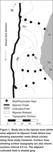
The study site is located approximately 30 km northwest of Hamilton, Ontario in an agricultural watershed in Flamborough, Ontario. This study was conducted in a 50 m wide riparian riverine deciduous swamp located between Spencer Creek and a naturally-drained agricultural field, approximately 1 km downstream from the Valens Reservoir in Flamborough (). The width of the buffer strip follows the natural contours of the landscape and thus has not varied with time. This width meets current Ontario Best Management Practice guidelines.
Figure 1. Study site in the riparian zone (white area) adjacent to Spencer Creek (black line) showing piezometer nests (black circles) along three study transects. Contour lines showing surface topography are also shown (contour interval 0.5 m). The adjacent cultivated field is shaded grey.
Conventional tillage and crop rotation practices (barley, oats, soybeans, corn) have been used in upslope fields at the site for decades and inorganic fertilizers (19-19-19 NPK, 202 kg ha1 yr1) are applied to fields in the spring months. Cattle manure is also periodically applied in the basin. Although fields receive both inorganic and organic fertilizers, which may subsequently be transported via surface runoff or shallow groundwater flow into Spencer Creek, problems related to eutrophication do not appear to exist at the site at this time. Spencer Creek passes through the Beverly Swamp, and subsequently drains into Hamilton Harbour, Lake Ontario. Thus, changes in either stream flow or contaminant concentrations have the potential to significantly impact downstream ecosystems.
Organic soil is present to a depth of approximately 0.3 m at the field edge (3942% organic content), but increases in thickness to 1.0 m at the edge of the stream (2234% organic content). This organic layer is underlain by sands (ranging in grain diameter from 0.055 mm; <1% organic content) throughout most of the riparian zone, and silt and clay lenses with some organic matter (grain diameter 0.0020.05 mm; 6% organic content) are present in the near-stream zone to a depth of approximately 2 m. The riparian wetland is treed (silver maple, cedar, oak) and characterized by understory vegetation (stinging nettle, sensitive fern, jewelweed, various tall grass species).
The topographic gradient from the topographic high in the adjacent upland field to the riparian area is approximately 0.04, whereas the topography of the riparian zone is flat, with gradients of approximately 0.003 from field down to the stream (transverse to the stream). In the riparian zone, there is a topographic gradient in a southerly direction (longitudinal to the stream, from T1 to T4) of approximately 0.02 ().
Flow in Spencer Creek is controlled by the Valens Dam and Reservoir, located upstream of the site. The dam consists of a series of stop-logs on top of a concrete drop inlet structure. A valve in the bottom portion of the dam provides control over discharge from the reservoir into the stream. In late autumn (OctoberNovember), in preparation for the winter and subsequent spring melt, the stop-logs are removed and the valve is opened to lower the reservoir water levels. In the summer, in order to maintain appropriate water levels for recreation and downstream users, the conservation authority reduces discharge to Spencer Creek to increase or maintain reservoir water levels, although episodic increases to discharge rates are executed to lower reservoir water levels under wet conditions. A marsh, dominated by Reed Canary Grass (Phalaris arundinaceae) is located between the reservoir outlet and the riparian zone.
Experimental Design
The approach taken in this field study was to investigate changes in P concentration in pore water and stream water in response to flooding. More specifically, groundwater and stream P concentrations were measured at regular intervals (under both wet and dry conditions) over a summer season, and subsequently interpreted to determine whether these concentrations changed in response to flooding from the upstream dam. Hydrologic and water quality measurements were taken in Spencer Creek and in a series of nested piezometers along three transects (T1, T3, T4) which span the riparian zone from the agricultural field to the near-stream zone (). Water quality parameters measured included soluble reactive phosphorus (SRP), total phosphorus (TP) and dissolved oxygen (DO) concentrations. Both SRP and TP fractions in water were analyzed to elucidate the processes governing P transport (i.e., entrainment of sediments or desorption of P), and DO concentrations were taken to determine if flooding resulted in a change in redox status (and thus the solubility of P) throughout the riparian zone.
Hydrology
Precipitation and Streamflow
Flow data from the Valens Reservoir into Spencer Creek (upstream from T1) was provided by the Hamilton Conservation Authority. Mean daily discharge from the reservoir is estimated from a combination of flow through a drain valve near the reservoir bottom as well as water levels in the reservoir, as water flows both above and below the dam during wet periods. Water level was measured continuously at one location in the stream (Spencer Creek) at T1 using a Model U20 Water Level Logger (Onset Computer Corp., Bourne, MA) in a stilling well and discharges were calculated from a stage-discharge relationship developed over a four-year period (Kaufman et al., Citation2005). Throughout the study period, precipitation was recorded at 15-minute intervals at a nearby HOBO meteorological tower with a tipping bucket recorder (Onset Computer Corp.), approximately 50 m away from the riparian zone. On October 16, 2006, a controlled flooding of the riparian zone occurred, when the upstream reservoir was released at full capacity for a period of 24 hours.
Groundwater Hydrology
In the riparian zone, piezometer nests (0.5, 1.0, 1.5 m depth) and monitoring wells (2 m depth) were installed at fourfive locations along transects T1, T3 and T4 (). Two additional wells were installed between T1 and T3 for mapping the water table position throughout the riparian zone (). Along the three transects, piezometers installed at 48 m from the field edge were located in the near stream zone, approximately 0.3 m away from the stream margin. Piezometers and wells were constructed using PVC pipe (0.03 m ID; 0.15 m slot length). Water level measurements and water samples were collected at 12 week intervals between May and August, 2006 (inclusive). Piezometers along transect T3 were sampled less frequently (5 dates) than T1 and T4 (8 dates) during the pre-flood period. Water level measurements were taken daily from piezometers along all three transects from October 1520, 2006, as well as at two locations in the stream (T1, T4).
Two additional drive-point piezometers (0.5, 1.0 m depth) were installed in the stream bed at T1 and T4 (2 m from the stream margin). Porous (6090 m) polyethylene filtered drive-point piezometers were constructed using stand-pipe tips 21.8 cm in length, set within a perforated 25 mm ID PVC body and connected with 25 mm ID PVC riser pipes. The in-stream piezometers were not installed until late in summer (July) and thus were sampled much less frequently than the riparian piezometers throughout the study period. As such, data from these piezometers have been used to provide insight on general hydrologic flow patterns and have not been included in the graphical and statistical analyses.
The position and elevation of all piezometers and wells were surveyed using a Total Survey Station. All piezometers and wells were purged three times before measurements commenced. The saturated hydraulic conductivity (Ksat) of soil and stream sediment was measured for each piezometer using bail tests (Hvorslev, Citation1951). Hydraulic heads and water table elevation were measured manually with an electronic water level sensor prior to the purging of piezometers.
Water Chemistry
Water samples were collected from piezometers and the stream at the same times that hydrology measurements were made (12 week intervals during the pre-flood period and daily during the controlled flood). Surface water samples from overbank flooding across the riparian zone were also collected on the peak flood day. Overbank flooding was not observed on any other day during the study period, although some standing water was observed in topographic lows in the riparian zone on some dates.
Water samples were collected within 24 hours following the purging of piezometers. Piezometers were capped to prevent contamination from rainfall and atmospheric deposition, and to minimize gaseous exchange between water inside of the piezometers and the atmosphere. A small hole was drilled in the side of each piezometer to avoid interference with pressure. Groundwater dissolved oxygen concentrations (DO) were measured 24 hours after the piezometers were purged. Measurements were taken in situ using a calibrated DO meter (ORION Model 840) probe inserted into piezometers. The probe was held approximately 3 cm from the bottom of the piezometer, well below the water surface. Although it is preferable to measure DO concentrations using a flow-cell apparatus, this was not possible due to the limited quantity of water available from each piezometer. Thus, DO concentrations should be treated with some caution. Groundwater samples were subsequently collected using a peristaltic pump. Grab samples of stream water were also collected in the centroid of flow. All water samples were placed in acid washed (20% H2SO4), triple-rinsed polyethylene bottles, and transported to the laboratory in coolers equipped with ice packs. A subsample was filtered (0.45 m pore size) within three to four hours of sample collection for the analysis of SRP. An additional 100 mL subsample was acidified (0.2% H2SO4) then later digested before measuring TP concentrations. Water samples were analyzed for SRP and TP using the stannous chlorideammonium molybdate method (American Public Health Association (APHA), Citation1995). Detection limit of the procedure is 1g L1, and analytical precision is 5% of reported values, based on replicate analysis of 5% of the samples.
Statistical Analysis
Phosphorus concentrations are not normally distributed. The data were log-transformed to generate a normal distribution of the data set. A three-way analysis of variance (ANOVA) was run on SRP and TP concentrations in groundwater, for each of the three depths (0.5, 1.0 and 1.5 m). Factors used in the ANOVA were: (1) Flow (pre-flood versus flood conditions), (2) Transv. (spatial differences between five positions on each transect, to test for spatial differences across the riparian zone, transverse to the stream), and (3) Longit. (spatial differences between T1, T3 and T4 to test for spatial differences in the longitudinal direction).
Results
Streamflow During Flood and Non-Flood Conditions
During the study period, precipitation input for the period May to October 2006 (451 mm) was higher than the 30-year average (19702000) of 385 mm (Environment Canada, Citation2007). Precipitation was fairly evenly distributed throughout the study period. Throughout the study period, streamflow in Spencer Creek was influenced by a combination of precipitation events and variable flow rates from the upstream Valens Reservoir. In general, flow in the stream was controlled upstream of the study site at the Valens Reservoir, which typically releases water at a rates between 1550 L s1 during baseflow periods (). However, flow in Spencer Creek increased in response to increased rates of discharge from the reservoir (), although the magnitude of streamflow response varied with antecedent flow conditions. For example, large volumes of discharge (>800 L s1) from the dam in July (baseflow, dry antecedent conditions) produced a much smaller streamflow response than similar flows in October (wet antecedent conditions) (). Flow at the study site (in Spencer Creek) ranged from <1 L s1 to 140 L s1 during the pre-flood period, but increased to more than 200 L s1 during the October reservoir release (). Stream discharge during the flood period was approximately 1.4 times higher than the maximum discharge measured during storms that occurred during the pre-flood period. During flooding, the stream stage rose and overbank flooding occurred.
Figure 2. (a) Precipitation (left y-axis) and flow from Valens Reservoir (right y-axis), (b) Discharge in Spencer Creek (left y-axis) and stream water concentrations of total phosphorus (right y-axis), and (c) Discharge in Spencer Creek (left y-axis) and stream water soluble reactive phosphorus concentrations (right y-axis) throughout the study season. Phosphorus concentrations in the stream at T1 are shown with black circles and T4 are shown with white circles. Arrows show the period during which the flood occurred.
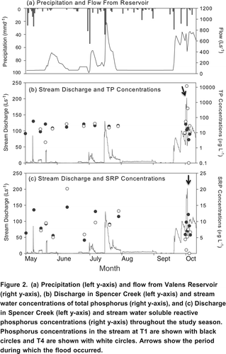
Stream flow at the study site was lower than discharge observed at the dam outflow under both high and low flow conditions (), suggesting that groundwater recharge (or stream loss) occurred along the channel between the reservoir outflow and the study site.
Groundwater Hydrology
The characterization and quantification of groundwater flow in this riparian zone is difficult due to the flat topography and low hydraulic gradients ( ). Saturated hydraulic conductivities (Ksat) of riparian soil are variable both within and among transects. At both T1 and T3, shallower soils (50 cm) are more conductive (averaging 8105 and 9105 cm s1, respectively, at five locations on each transect) than deeper soils (100150 cm) (averaging 1106 and 7106 cm s1, respectively, at five locations on each transect). Soil at all depths at T4 have Ksat values greater than those observed at the other two transects (21043104 cm s1). Measurements taken in 2007 yielded comparable results, giving confidence in these measurements. Ksat values such as these are typical for the soil textures present at the site (a heterogeneous mixture of a range of textures from poorly sorted sand silt clay to sand) (Freeze and Cherry, Citation1979). These spatial patterns suggest that there is a large degree of heterogeneity in the hydraulic properties of shallow soils at the study site and suggest that groundwater flow patterns may be complex.
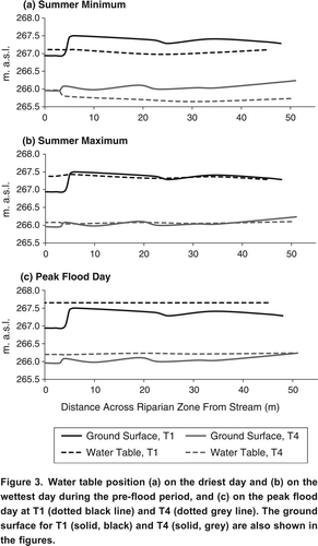
Measurements of hydraulic head collected from 36 piezometers on 15 dates demonstrate hydraulic gradients in the shallow aquifer that are spatially and temporally variable. Groundwater horizontal hydraulic gradients (transverse to the stream) in the shallow aquifer ranged from 0.02 (away from the stream) to +0.02 (toward the stream) during pre-flood conditions, and from 0.08 (away from the stream) to +0.07 (toward the stream) during flood conditions. Vertical hydraulic gradients at five piezometer nests within each of the three transects averaged 0.120.08 (recharge), although positive vertical hydraulic gradients (discharge) were also observed at some locations on some dates. Vertical hydraulic gradients (recharge) at individual nests in the riparian zone increased during flood conditions (0.480.43) and were dominantly negative (recharge) at T1 during flooding.
The heterogeneity of riparian soil and the low hydraulic gradients observed during the study period confound the ability to characterize flow in this landscape with any degree of certainty. No clear patterns in groundwater flow in the shallow aquifer can be seen along (transverse to the stream) or within (vertical gradients) the transects at any time, with the exception of T1 during flood conditions when some groundwater recharge appeared to be occurring, and also at the near-stream edge of T4, where horizontal hydraulic gradients are typically negative (away from the stream).
However, some general patterns in flow were observed in the riparian zone. During both the pre-flood period and during flooding due to reservoir release, a consistent horizontal hydraulic gradient (0.0130.002 pre-flood; 0.0140.001 flood) was observed longitudinal to the stream (in the southerly direction) between T1 and T4. This general direction of flow is also apparent from the water table position throughout the riparian zone (). Water table position throughout the study site generally follows topography and the water table is found at or close to the soil surface (). Water table gradients indicate that the direction of groundwater flow is in the longitudinal direction, parallel to Spencer Creek, from T1 to T4 (, ). This spatial pattern persisted under both wet and dry conditions, as well as during flood conditions during the study period and also in 2007 (Leach, Citation2009). Although the water table was observed at the soil surface in some locations (i.e., topographic lows) in the riparian zone during the pre-flood period, this water appeared to be stagnant and no currents were observed. In contrast, during flood conditions, stream overbank flow was observed (). At this time, visual observations were made of currents in surface water flowing from T1 to T4, longitudinal to the stream.
Figure 3. Water table position (a) on the driest day and (b) on the wettest day during the pre-flood period, and (c) on the peak flood day at T1 (dotted black line) and T4 (dotted grey line). The ground surface for T1 (solid, black) and T4 (solid, grey) are also shown in the figures.
Negative (downward) hydraulic gradients were observed in the stream bed (data not shown), indicating that the stream was recharging the groundwater system. Streambed vertical hydraulic gradients at T1 and T4 were, on average, 0.3 and 0.58 (three dates measured during pre-flood conditions, n=6 each at T1 and T4) and 1.15 and 0.89 (five dates measured during flood conditions, n=10 each at T1 and T4), respectively, indicating that recharge through the streambed was greater during flood conditions.
Stream stage and water table position throughout the riparian zone also suggest that the stream was supplying groundwater to the riparian zone, as flow reversals (flow out of the stream, into the riparian zone) were observed during both pre-flood and flood conditions (). Observations were made of currents in surface water flowing away from the stream downstream of T4, flowing in a southeasterly direction (see ). Negative vertical hydraulic gradients (recharge) were observed in the aquifer at T1 during the flood, although this was not observed at T3 or T4, where no vertical hydraulic gradients were observed. In contrast, vertical hydraulic gradients were low in the riparian zone during pre-flood conditions. The response of the water table in the riparian zone to flooding was immediate and synchronous across the riparian zone both during the flood peak and recession periods.
The stream stage and water table data, combined with the limited groundwater data from the stream bed and riparian zone, indicate that both topography and flow from the upstream reservoir influence the movement of groundwater flow in this riparian zone. However, the weak hydraulic gradients and heterogeneity of the landscape make it difficult to characterize specific hydrologic flow paths (or flow rates) within the riparian zone. Consequently, estimates of groundwater flux and phosphorus mass transport presented in this manuscript should be treated with some caution.
Groundwater Phosphorus Concentrations
Spatial Patterns in Groundwater Phosphorus Concentrations
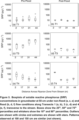
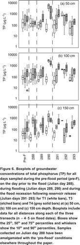
No clear patterns are observed in TP concentrations in the aquifer across the three transects (transverse to the stream) (p>0.001, ) at any of the three depths sampled, despite the fact that the riparian zone is adjacent to a cultivated field. In contrast, spatial differences in SRP concentrations are observed along transects, transverse to the stream (), although these patterns are inconsistent. For example, in piezometers at 50 cm, SRP concentrations appears to be smaller near the stream at T3, but larger near the stream at T4.
Table 1. Results from a three-way Analysis of Variance (ANOVA) for a comparison of TP and SRP concentrations (log-transformed) in groundwater, testing for differences with flow conditions [Flow] (under pre-flood versus flood conditions), spatial trends in the transverse direction [Transv.] (along transects, between the stream and field), and spatial trends in the longitudinal direction [Longit.] (differences among the three transects). Significance levels below 0.001 are shown in bold.
Spatial differences in groundwater TP and SRP concentrations were observed throughout the riparian zone ( ). Total phosphorus concentrations in the aquifer increased at T3 and T4 relative to T1 under both pre-flood and flood conditions (, ), suggesting that the riparian zone was a source of TP to groundwater between T1 and the other two transects (longitudinal to the stream). This occurred under both pre-flood and flood conditions, but was particularly evident during the flood at 50 cm and 100 cm depths ( ). Patterns in SRP concentrations are less clear. During the pre-flood period, SRP concentrations were larger at T3 and T4 relative to T1 at 50 cm and 100 cm ( ), but not at 150 cm ().
Figure 4. Boxplots of total phosphorus (TP) concentrations in groundwater at 50 cm under pre-flood (a, c, e) and flood (b, d, f) flow conditions along Transects 1 (a, b), 3 (c, d) and 4 (e, f), transverse to the stream. Boxes show the 25th, 50th and 75th percentiles and whiskers show the 10th and 90th percentiles. Outliers are shown with circles and extremes are shown with stars. Patterns observed at 100 and 150 cm are similar (not shown).
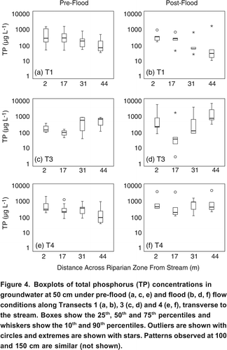
Figure 5. Boxplots of soluble reactive phosphorus (SRP) concentrations in groundwater at 50 cm under non-flood (a, c, e) and flood (b, d, f) flow conditions along Transects 1 (a, b), 3 (c, d) and 4 (e, f), transverse to the stream. Boxes show the 25th, 50th and 75th percentiles and whiskers show the 10th and 90th percentiles. Outliers are shown with circles and extremes are shown with stars. Patterns observed at 100 and 150 cm are similar (not shown).
In general, TP and SRP concentrations did not vary significantly with depth (p>0.001, ) for any transect. This is likely because soil texture is similar (sandy silt) between 50150 cm depth and little vertical groundwater flow occurred to transport P vertically. Some exceptions are observed. For example, on the peak flood day (Julian Date 290), groundwater samples collected at 50 cm at T3 and T4 had much larger TP concentrations (50008000 g L1) than samples collected from deeper soils. The TP concentrations of two surface water samples (overbank flooding over surface of riparian zone) collected on the same day were 19,000 and 41,000 g L1, suggesting that the concentrations observed at 50 cm may have originated from surface water inputs. However, at the time of sampling, vertical hydraulic gradients were not observed at T3 or T4, suggesting that the elevated concentrations may not have been a result of direct percolation of surface water at T3 and T4. It is possible that the large amounts of TP observed in the groundwater originated from soils located upstream from T3 and T4. The strongly elevated TP concentrations at 50 cm and 100 cm only occurred on the peak flood date, and during days following the flood TP concentrations in groundwater were similar at the three depths.
Temporal Patterns in Groundwater Phosphorus Concentrations
Concentrations of TP increased by a factor of 3 to 5 during flooding at both T3 and T4 (5,0008,000 g L1 on the peak flood date) compared to <1,500 g L1 observed during the remainder of the study period (). However, flooding did not produce a change in TP concentrations in groundwater at T1 (). TP concentrations at T3 returned to pre-flood conditions within 24 hours of peak discharge, whereas the elevated TP concentrations at T4 persisted for several days. Although they remained elevated above pre-flood concentrations, TP concentrations in groundwater steadily decreased in the days following the flood and returned to pre-flood levels within three days. Due to the fact that TP levels returned quickly to pre-flood levels during the post-flood period, statistical comparisons of pre-flood and flood conditions were insignificant (p>0.001, ).
Figure 6. Boxplots of groundwater concentrations of total phosphorus (TP) for all days sampled during the pre-flood period (pre-F), on the day prior to the flood (Julian day 288), during flooding (Julian days 289, 290) and during the flood recession following reservoir release (Julian days 291293) for T1 (white bars), T3 (etched bars) and T4 (grey solid bars) at (a) 50 cm, (b) 100 cm and (c) 150 cm depth. Boxplots include data for all distances along each of the three transects (n=45 on flood dates). Boxes show the 25th, 50th and 75th percentiles and whiskers show the 10th and 90th percentiles. Samples collected on Julian day 288 have been amalgamated with the pre-flood conditions elsewhere throughout the paper.
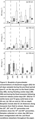
SRP concentrations decreased during flood conditions at T1 and T3 but not at T4 (). This was observed at 50 cm and 100 cm depth but not at 150 cm depth. The decrease in SRP concentrations at T1 appears to correspond with the influx of more oxygen-rich water during the flood period ( ). DO data are not available for T3. During the flood, overbank flooding and negative vertical hydraulic gradients (recharge) were observed in the stream and riparian zone at T1. The DO concentrations and groundwater SRP concentrations were similar to levels measured in the stream during the flood. The data suggest that stream water may have been mixing with the groundwater in this section of the riparian zone. Negative vertical hydraulic gradients (recharge) were observed in some but not all sections of T3.
Figure 7. Boxplots of groundwater concentrations of soluble reactive phosphorus (SRP) for all days sampled during the pre-flood period (pre-F), on the day prior to the flood (Julian day 288), during flooding (Julian days 289, 290) and during the flood recession following reservoir release (Julian days 291293) for T1 (white bars), T3 (etched bars) and T4 (grey solid bars) at (a) 50 cm, (b) 100 cm and (c) 150 cm depth. Boxplots include data for all distances along each of the three transects (n=45 on flood dates). Boxes show the 25th, 50th and 75th percentiles and whiskers show the 10th and 90th percentiles. Samples collected on Julian day 288 have been amalgamated with the pre-flood conditions elsewhere throughout the paper.
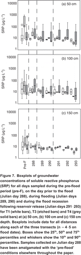
Figure 8. Boxplots of groundwater concentrations of dissolved oxygen (DO) for all days sampled during the pre-flood period (pre-F), on the day prior to the flood (Julian day 288), during flooding (Julian days 289, 290) and during the flood recession following reservoir release (Julian days 291293) for T1 (white bars) and T4 (grey solid bars) at (a) 50 cm), (b) 100 cm and (c) 150 cm depth. Boxplots include data for all distances along transects from field to stream. Boxes show the 25th, 50th and 75th percentiles and whiskers show the 10th and 90th percentiles. Samples collected on Julian day 288 have been amalgamated with the pre-flood conditions elsewhere throughout the paper.
Due to the complex hydrology of the site, P fluxes cannot be calculated with a high degree of certainty. However, an approximation of P fluxes in groundwater during pre-flood period and autumn flooding can be generated using the data set. A range of TP and SRP fluxes under both flow conditions are presented in . These fluxes were calculated for 50, 100 and 150 cm depth using the median hydraulic gradients for each flow condition and the median saturated hydraulic conductivities to generate a Darcian groundwater flux, and then multiplying this by the median, 25th and 75th percentile groundwater TP and SRP concentrations observed at each depth for both transects. The results were then summed for the three depths to estimate a flux between T1 and T4 (the endpoints). In general, both TP and SRP fluxes were low at this site due to low groundwater flow rates measured at the study site (). However, it appears that the riparian zone was a source of TP and SRP to the shallow aquifer under pre-flood and flood conditions (). Due to the uncertainty around the flow of groundwater in the shallow aquifer, these estimates should be treated with caution.
Table 2. Estimates of horizontal TP and SRP fluxes integrated across the top 150 cm of riparian sediments under pre-flood and flood conditions. A positive flux indicates that the mass of P is increasing in the groundwater system whereas a negative flux indicates that the mass of P is decreasing. Fluxes are estimated by multiplying the median hydraulic gradient and saturated hydraulic conductivity for each depth to generate a Darcian groundwater flux. Groundwater fluxes were subsequently multiplied by the median, 25th and 75th percentile phosphorus concentrations at each depth to generate a range in possible phosphorus fluxes.
Stream Water Phosphorus
Total phosphorus concentrations in Spencer Creek were highly variable between pre-flood and flood conditions. During pre-flood, median TP concentrations were less than 60 g L1 and showed little variability (). During flood conditions, TP concentrations at T1 were comparable to those during the pre-flood period, but were greater and more variable at T4 (). Stream concentrations of TP at T4 were consistently higher than at T1 throughout the duration of the flood. Most notably, on the peak flood day (Julian day 290), TP concentrations were 15 g L1 in the stream adjacent to T1, and 12,000 g L1 in the stream adjacent to T4 (), indicating that the riparian zone was supplying TP to the stream on this day. These extremely high concentrations were only observed on one day. The following day, TP in the stream decreased to 400 g L1 at T4, which is larger than during either pre-flood or storm conditions. The data suggest that pulses of TP may be mobilized from the riparian zone into the stream in response to flooding for short durations of time. Although the riparian zone appears to have been supplying TP to the stream, this was likely via flooding on the surface of the riparian zone surface (stream overbank flow and spillage over the riparian zone surface, and the subsequent mobilization of P from the soil surface) rather than groundwater flow, given the exceptionally high concentrations of TP observed in surface flood waters in the riparian zone and in the stream (in comparison to groundwater TP concentrations), and also in light of the fact that groundwater flow did not appear to be towards the stream and the fact that no vertical hydraulic gradients were observed in this section of the riparian zone. Visual observations made during this time support the flow of surface overland flow (as well as fine sediment), moving in a southerly direction, longitudinal to the stream, through the riparian zone. During the flood, SRP concentrations in Spencer Creek were less variable than TP, ranging from 1.2 g L1 to>20.2 g L1 over the study period (). Thus, flooding did not appear to significantly affect stream SRP levels.
Discussion
Riparian Zone Hydrology
The hydrology of the site appeared to be governed by a combination of topography and contributions from the upstream reservoir. The dominant direction of groundwater movement in the shallow aquifer is longitudinal to the stream at this site rather than transverse to the stream (from field to stream) as is more commonly observed (e.g., Vidon and Hill, Citation2004). This drainage pattern has implications for the movement of contaminants in the landscape.
Hydraulic gradients are low at the site compared to what has been observed in other riparian wetlands in the region (e.g., Harris, Citation1999; Macrae, Citation2003; Mengis et al., Citation1999; Stainton, Citation2000). Hydraulic conductivities, which are generally characteristic of a sand-silt substrate (Freeze and Cherry, Citation1979) are comparable in magnitude to what has been observed elsewhere in the region (e.g., Harris, Citation1999; Macrae, Citation2003; Mengis et al., Citation1999; Stainton, Citation2000; Warren et al., Citation2001), but more variable than what has typically been observed within individual studies, demonstrating the fact that a large degree of heterogeneity exists at this site. Surface and shallow soils (50 cm) are more conductive than deeper soils, facilitating a greater groundwater flux in this layer. Overall, the low hydraulic gradients at the site resulted in low rates of groundwater movement in the shallow aquifer.
At the study site, Spencer Creek and its surrounding riparian area were consistently zones of groundwater recharge. This is in agreement with other studies that have found this section of Spencer Creek to be an influent system (recharging the groundwater system) (Young, Citation2001; Warren et al., Citation2001). Vertical hydraulic gradients (recharge) increased both in the streambed itself and in the adjacent riparian area (at T1 and some areas on T3) during flooding, suggesting that groundwater recharge increased when reservoir discharge rates were increased. Indeed, Duke et al. (Citation2007) also observed that the impoundment of a second-order stream resulted in increased groundwater recharge in an adjacent riparian wetland.
Flow in Spencer Creek also increased when reservoir releases were executed (), resulting in overbank flow and flooding of the riparian area on the peak flood date. This flooding persisted for several days after the controlled dam release. Such flooding has been observed in subsequent years during autumn dam releases (Leach, 2009). Horizontal currents (longitudinal to the stream) were observed in overbank flow during these periods. During flooding, the groundwater system along the study reach received inputs from stream water, as evidenced by the negative streambed gradient as well as the negative vertical groundwater gradient at T1. These observations are consistent with the findings of Duke et al. (Citation2007) who reported that stream water supplied by an upstream impoundment recharged the groundwater system in the riparian zone, and caused groundwater flow to move in a longitudinal direction to the stream. They discussed the potential for mixing between the stream and groundwater systems, as well as hyporheic exchange, where groundwater flow re-enters the stream at downstream portions of the reach. This hydrologic flow pattern has strong implications for P transfer in groundwater flow.
Phosphorus Mobility in the Riparian Zone
Concentrations of TP and SRP in shallow groundwater were highly variable in the Spencer Creek riparian zone. No clear spatial patterns were observed in the data either along each transect (running transverse to the stream) or with depth. This observation is not comparable with other studies that show TP and SRP concentrations and transport in shallow groundwater systems can vary both vertically with depth (Heathwaite and Dils, Citation2000) and horizontally with distance from agricultural fields (Banaszuk et al., Citation2005). Because of the low topographic gradient and subsurface stratigraphy of the study area, groundwater movement in the shallow aquifer occurs longitudinally through the riparian zone from T1 to T4, rather than perpendicular to the stream. Thus, the agricultural fields adjacent to the riparian wetland do not appear to be contributing P via direct groundwater flow at this site.
Spatial patterns in SRP and TP concentrations in groundwater were instead observed in the direction of apparent groundwater flow, between T1 and T3, longitudinal to the stream. These patterns were occasionally observed under pre-flood conditions, but were most apparent during flood conditions ( and ). During reservoir release, there was a 3 to 5 fold increase in the concentration of shallow groundwater TP to a maximum concentration of 8 mg P L1, although this only persisted for a short time and groundwater TP concentrations returned quickly to pre-flood levels within days of the flood. The greatest increases in TP concentrations during flooding were observed in the 50 cm and 100 cm layers of soil at T3 and T4 on the peak flood dates. Surface runoff in the riparian zone (overbank flow) measured on the same dates had exceptionally large concentrations of TP. These patterns in surface water and groundwater TP concentrations, combined with the stronger negative vertical hydraulic gradients (recharge) observed during the same period, indicate that the surface runoff (overbank flooding) was entering the groundwater system and mobilizing P from the surface into the subsurface. This suggests that the P in the groundwater system originates from the riparian zone surface and surface soil, rather than from the adjacent agricultural fields. Previous studies have shown that high water tables in riparian zones can cause leaching of decayed vegetation (Takatert et al., Citation1999), which increases concentrations of particulate organic P in groundwater. At this site, groundwater subsequently migrates into the Beverly Swamp, south of the research site. The fate of the groundwater and the P in the groundwater, once it enters the swamp, is not known.
During the flood period there was a sharp decline in groundwater SRP concentrations. It is possible that the influx of oxygen-rich water from the dam release enhanced sorption of SRP by affecting the redox status of riparian sediments (Holtan et al., Citation1988), although simple dilution of groundwater by streamflow is equally plausible. Carlyle and Hill (Citation2001) reported a negative relationship between groundwater SRP and DO concentrations in the Boyne River riparian zone in southern Ontario. In a controlled laboratory study, Surridge et al. (Citation2007) studied the release of phosphorus to porewater and surface water from cores of river riparian sediments and reported that the release of P from the peat samples was controlled primarily by the reductive dissolution of Fe3+ P under anaerobic conditions.
Exceptionally large TP concentrations (12,000 g L1) were observed in the stream at T4 on the peak flood date. Such large concentrations were not observed at T1, indicating that the large concentrations of P in the stream did not originate at the reservoir. In the present study, the flux and speciation of particulate P in flood water from Spencer Creek to T1 and T4 was not measured during reservoir release. Accordingly, it is not possible to assess whether higher TP concentrations observed in Spencer Creek at T4 were due to: 1) eroded P enriched particulate matter from the riparian zone or 2) materials re-suspended in the stream between T1 and T4. However, given the large concentrations of TP in overbank flood water in the riparian zone, it is most likely that the high TP concentrations in the stream were a result of mixing with overbank flood water on the riparian zone surface. The downstream fate of these pulses of P into Spencer Creek are not known, but should be investigated.
Conclusions
Phosphorus concentrations were measured in a riparian zone prior to and during flooding from an upstream reservoir to investigate the impacts of flooding on P dynamics in a shallow aquifer and an adjacent stream. The low gradient topography of the riparian zone, and discharge from an upstream reservoir caused groundwater to flow generally longitudinally along the riparian zone, parallel to the stream, rather than transverse to the stream, and thus limited the impacts of the adjacent cultivated field at this site.
During pre-flood and especially during flood conditions, TP concentrations increased in the shallow aquifer, in the longitudinal direction. The riparian zone surface was likely the source of the TP. These results demonstrate the fact that riparian zones can act as sources of P in shallow groundwater, and large hydrologic events such as overbank flooding have the potential to increase these P concentrations. This may be problematic in landscapes where groundwater enters streams.
Streamflow concentrations of TP at the downstream location increased during flooding. The major mechanism transporting TP into the stream appears to have been surface runoff due to stream spillage and overbank flooding of the riparian zone. These results demonstrate that rapid releases of runoff of reservoirs have the potential to mobilize large quantities of P if overbank flooding occurs. These results also present an analogue for large storms and demonstrate the fact that riparian wetlands can supply large quantities of P to adjacent streams if overbank flooding occurs. Strategies for minimizing the occurrence of overbank flooding, such as draining reservoirs more slowly, should be investigated.
Acknowledgements
The authors acknowledge NSERC (JSP), Ducks Unlimited Canada and the University of Waterloo for funding and logistical support. Jamee DeSimone, Bobby Katanchi and Karen Edmundson are acknowledged for field and laboratory assistance. The Hamilton Conservation Authority is gratefully acknowledged for the provision of flow data from the Valens Reservoir and for conducting the controlled flood.
References
- American Public Health Association (APHA). 1995. Standard methods for the examination of water and wastewater. 19th edition. New York: American Public Health Association.
- Banaszuk , P. , A. , Wysocka-Czubaszek and P. , Kondratiuk . 2005 . Spatial and temporal patterns of groundwater chemistry in the river riparian zone . Agriculture Ecosystems & Environment , 107 : 167 – 179 .
- Bridgham , S. D. , C. A. , Johnston , J. P. , Schubaner-Berigan and P. , Weishampel . 2001 . Phosphorus sorption dynamics in soils and coupling with surface and pore water in riparian wetlands . Soil Science Society of American Journal , 65 : 577 – 588 .
- Carlyle , G. C. and A. R. , Hill . 2001 . Groundwater phosphate dynamics in a river riparian zone: effects of hydrologic flowpaths, lithology and redox chemistry . Journal of Hydrology , 247 : 151 – 168 .
- Cooper , J. R. and J. W. , Gilliam . 1987 . Phosphorus redistribution from cultivated fields into riparian areas . Soil Science Society of America Journal , 51 : 1600 – 1604 .
- Duke , J. R. , J. D. , White , P. M. , Allen and R. S. , Muttiah . 2007 . Riparian influence on hyporheic-zone formation downstream of a small dam in the Blackland Prairie region of Texas . Hydrological Processes , 21 ( 2 ) : 141 – 150 .
- Environment Canada. 2007. Climate normals or averages 1961-1990. http://climate.weatheroffice.ec.gc.ca/climate_normals/index_1961_1990_e.html . (accessed May 2007)http://climate.weatheroffice.ec.gc.ca/climate_normals/index_1961_1990_e.html
- Flores-Lopez , F. , L. D. , Geohring , S. K. , Giri and T. S. , Steenhuis . 2005 . Phosphorus transport by monitoring groundwater and interflow discharge in hydrologically sensitive areas . Geophysical Research Abstract , 7 : 10153
- Freeze R. A. and J. A. Cherry. 1979. Groundwater. Englewood Cliffs, NJ: Prentice-Hall Inc., 604 pp.
- Ho , G. E. and N. , Suprihanto . 1995 . Phosphorus movement through soils and groundwater: application of a time-dependent sorption model . Water Science and Technology , 31 ( 9 ) : 83 – 90 .
- Harris M. 1999. Nitrate attenuation in a narrow non-forested riparian buffer zone in an agricultural watershed in Southern Ontario, M.Sc. Thesis, Wilfrid Laurier University. Waterloo, Ontario. 305 pp.
- Heathwaite , A. L. and R. M. , Dils . 2000 . Characterizing phosphorus loss in surface and subsurface hydrological pathways . The Science of the Total Environment , 251/252 : 523 – 538 .
- Hoffmann , C. C. , P. , Berg , M. , Dahl , S. E. , Larsen , H. E. , Andersen and B. , Andersen . 2006 . Groundwater flow and transport of nutrients through a riparian meadow-field data and modeling . Journal of Hydrology , 331 : 315 – 335 .
- Holford , I. C. R. and W. H. Jr. , Patrick . 1979 . Effects of reduction and pH changes on phosphate sorption and mobility in an acid soil . Soil Science Society of America Journal , 43 : 292
- Holtan , H. , L. , Kamp-Nielsen and A. O. , Stuanes . 1988 . Phosphorus in soil, water and sediment: an overview . Hydrobiologia , 170 : 19 – 34 .
- Hvorslev M. J. 1951. Time lag and soil permeability in groundwater observations. Waterways Experimental Station Bulletin 36, p. 150. Vicksburg, Mississippi: US Army Corps of Engineers.
- Jansson , M. B. and U. , Erlingsson . 2000 . Measurement and quantification of a sedimentation budget for a reservoir with regular flushing . Regulated Rivers: Research and Management , 16 : 279 – 306 .
- Kaufman , S. C. , J. M. , Waddington and B. A. , Branfireun . 2005 . Hydrogeomorphic controls on runoff in a temperate swamp . Hydrology and Earth System Sciences Discussions , 2 : 483 – 508 .
- Leach, M. 2009. Influence of an upstream dam on riparian zone hydrology and shallow groundwater nitrate dynamics. MSc Thesis, School of Geography & Earth Sciences, McMaster University, Hamilton, Ontario. 92 pp.
- Mander , U. , V. , Kuusemets , K. , Lohmus and T. , Mauring . 1997 . Efficiency and dimensioning of riparian buffer zones in agricultural catchments . Ecological Engineering , 8 : 299 – 324 .
- Macrae, M. L. 2003. Temporal variability in nutrient transport in a first-order agricultural basin in Southern Ontario. Ph.D. Thesis, Dept. of Geography and Environmental Studies, Wilfrid Laurier University. Waterloo, Ontario. 214 pp.
- Mengis , M. , S. L. , Schiff , M. , Harris , M. C. , English , R. , Aravena , R. J. , Elgood and A. M. , MacLean . 1999 . Multiple geochemical and isotopic approaches for assessing ground water attenuation in a riparian zone . Ground Water , 37 : 448 – 457 .
- Morris, G. L. and J. Fan. 1998. In reservoir sedimentation handbook: design and management of dams, reservoirs and watersheds for sustainable use. New York: McGraw-Hill, 848 pp.
- Osborne , L. L. and D. A. , Kovacic . 1993 . Riparian vegetated buffer strips in water-quality restoration and stream management . Freshwater Biology , 29 : 243 – 258 .
- Owens , P. H. and D. E. , Walling . 2002 . The phosphorus content of fluvial sediment in rural and industrialized river basins . Water Research , 36 : 685 – 701 .
- Palmer , R. and J. , O'Keefe . 1990 . Transported material in a small river with multiple impoundments . Freshwater Biology , 24 : 563 – 575 .
- Petts, G. E. 1984. Impounded rivers: perspectives for ecological management. Chichester: Wiley, 326 pp.
- Roden , E. E. and J. W. , Edmonds . 1997 . Phosphate mobilization in iron-rich anaerobic sediments: microbial Fe oxide reduction versus iron-sulfide formation . Archiv fr Hydrobiologie , 139 : 347 – 378 .
- Shantz , M. , E. , Dowsett , E. , Canham , G. , Tavernier , M. , Stone and J. S. , Price . 2004 . The effect of drawdown on suspended solids and phosphorus export from Columbia Lake, Waterloo, Canada . Hydrological Processes , 18 : 865 – 878 .
- Sharpley , A. N. , P. L. A. , Kleinman , R. W. , McDowell , M. , Gitau and R. B. , Bryant . 2002 . Modeling phosphorus transport in agricultural watersheds: processes and possibilities . Journal of Soil and Water Conservation , 57 ( 6 ) : 425 – 439 .
- Snyder , N. J. , S. , Mostaghimi , D. F. , Berry , R. B. , Reneau , S. , Hong , P. W. , McClellan and E. P. , Smith . 1998 . Impact of riparian forest buffers on agricultural nonpoint source pollution . Journal of American Water Resource Association , 34 ( 2 ) : 385 – 395 .
- Stainton R. T. 2000. Nutrient transport dynamics in shallow groundwater at the stream-riparian interface. MES thesis, University of Waterloo. 157 pp.
- Steiger , J. and A. M. , Gurnell . 2002 . Spatial hydrogeomorphological influences on sediment and nutrient deposition in riparian zones: observations from the Garonne River, France . Geomorphology , 49 : 1 – 23 .
- Surridge , B. W. J. , A.L. , Heathwaite and A. J. , Baird . 2006 . Groundwater-surface water interactions and phosphorus biogeochemistry in river floodplains . Geophysical Research Abstracts , 8 : 05792
- Surridge , B. W. J. , A. L. , Heathwaite and A. J. , Baird . 2007 . The release of phosphorus to porewater and surface water from river riparian zones . Journal of Environmental Quality , 36 : 1534 – 1544 .
- Takatert , N. , J. M. , Sanchez-Perez and M. , Tremolieres . 1999 . Spatial and temporal variations of nutrient concentration in the groundwater of a floodplain: effect of hydrology, vegetation and substrate . Hydrological Processes , 13 : 1511 – 1526 .
- Thoms , M. C. , J. M. , Foster and B. , Gawne . 2000 . Flood-plain sedimentation in a dryland river: the River Murray, Australia. In The role of erosion and sediment transport in nutrient and contaminant transfer, ed. M. Stone. Proceedings of an international symposium held at Waterloo, Canada, July 2000 . IAHS Publication , 263 : 227 – 236 .
- Vellidis , G. , R. , Lowrance , P. , Gay and R. K. , Hubbard . 2003 . Nutrient transport in a restored riparian wetland . Journal of Environmental Quality , 32 : 711 – 726 .
- Vidon , P. G. and A. R. , Hill . 2004 . Landscape controls on the hydrology of stream riparian zones . Journal of Hydrology , 292 ( 14 ) : 210 – 228 .
- Walling , D. E. , Q. , He and W. H. , Blake . 2000 . River flood plains as phosphorus sinks . IAHS Publication , 263 : 211 – 218 .
- Warren , F. J. , J. M. , Waddington , R. A. , Bourbonniere and S. M. , Day . 2001 . Effect of drought on hydrology and sulphate dynamics in a temperate swamp . Hydrological Processes , 15 : 3133 – 3150 .
- Young, M. 2001. Hydrological and biogeochemical controls on mercury fate and transport in a southern Ontario forested wetland. MSc Thesis, Department of Geography, University of Toronto. 118 pp.