Canada does not properly manage its flood risk. “Flood management” aims to reduce harmful impacts to people, the environment and the economy of a flood-prone area, and “risk” combines consideration of the flood hazard and its consequences. But those consequences are not all or, at least, not systematically quantified and so a full appreciation of flood risk remains, in most instances, unknown.
A hazard is an existing or potential future event with an adverse effect. In contrast, risk is defined as the product of the likelihood of a hazard occurring and its anticipated consequence. Vulnerable floodplain assets may include residential developments and infrastructure, business developments and activities on the floodplain, business activities associated with transport of goods and services, as well as social, ecological and historical values.
In this commentary we argue that for any flood-prone area where significant losses can be expected during extreme floods a series of steps should be taken that quantify risk and provide decision makers and the public with the tools to assess the benefits of a variety of flood risk reduction measures. Even though not widely implemented in Canada the need for flood risk assessments is strong, and flood risk analytical methods have been developed for some time and have achieved a high degree of sophistication (i.e. Ahmad and Simonovic, Citation2011).
Floods are the most widespread and most economically and socially significant geohazard on Earth. River and coastal floods, in an average year, kill more than 25,000 humans, affect 520 million people and render 3.2 million homeless, with annual cost to the world economy exceeding US $60 billion (Simonovic, Citation2009). Canada is no exception, though the loss of life is typically low due to relatively low development density and better emergency planning. Notwithstanding, in Canada floods have claimed the lives of at least 200 people during the 20th century and created over $2 billion in damage.
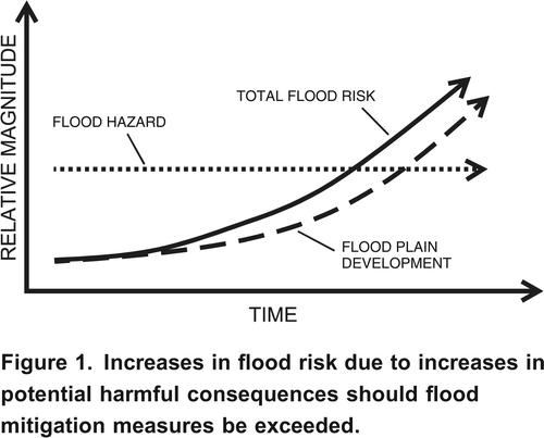
Flood hazard management in Canada is predicated on an event of arbitrary return period – the “design flood” – which forms the basis for the design of public infrastructure and flood protection. The design return period for river flooding through urban areas is fixed (in most instances in Canada it is 200 years) but the associated discharge is purely a statistical artifact that certainly is not fixed in an environment of changing climate and land use. Furthermore, consequences in terms of potential loss of life (more people living and working in the floodplain) and economic losses (property and infrastructure) continue to increase as settlement density increases, yet the design standard is locked even if the total flood risk increases. This paradox is exemplified in .
Figure 1. Increases in flood risk due to increases in potential harmful consequences should flood mitigation measures be exceeded.
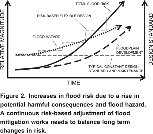
For many rivers in Canada, peak flows are irregularly recalculated, often only after damaging floods, and the design flow discharge is adjusted. However, this process is not linked to an automatic improvement of mitigation measures to account for changes in the recalculated peak flows. In this case, both hazard and consequences to elements at risk may increase. A case in point is Squamish River in southwestern British Columbia whose floodplain has witnessed a development boom since 2003. A recent study by CitationBauch and Hickin (2011) on that river demonstrated that the magnitude, frequency and duration of extreme floods are increasing significantly, which those authors attribute to a documented intensification of late summer and fall Pacific storms. The combination of increased floodplain development and an increase in flood hazard leads to the scenario depicted in . Since hazard and consequences are multiplicative in the risk equation, in this case, total flood risk will increase more than in .
Figure 2. Increases in flood risk due to a rise in potential harmful consequences and flood hazard. A continuous risk-based adjustment of flood mitigation works needs to balance long term changes in risk.
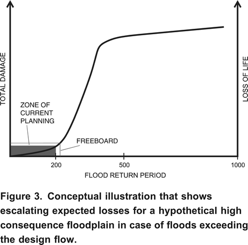
When and if the structural mitigation is adjusted through measures such as dyke improvements, floodways or river diversions, the increased flood hazard may at least partially be neutralized. But protective measures rarely keep pace with increases in development density, business activity, and infrastructure construction, which in many cases results in increased flood risk. The current reliance on a hazard-based approach to managing floods, assuming adequate mitigation system performance, results in relatively low losses for floods with probabilities higher than or equal to that of the design event. In cases of lower probability events, however, losses can be extreme. illustrates this concept. At some point potential damages and economic losses are limited by the density of homes and infrastructure existing on the floodplain and will thus level off. The fundamental question is whether society is willing to accept the inevitable losses for the flood probabilities exceeding those being used for mitigation design. If the answer is no, then the questions are ‘where lies the threshold for acceptable losses and who will define those?’
Figure 3. Conceptual illustration that shows escalating expected losses for a hypothetical high consequence floodplain in case of floods exceeding the design flow.
Fraser River may serve as an example for the concept of losses escalating beyond the design return period. While flood defenses for Fraser River are nominally designed for the flood of record of 1894 (associated with an approximate return period of 500 years), a recent study by Northwest Hydraulic Consultants (Citation2008) showed that the current defenses are in many cases inadequate to withstand even the 200-year return period flood. This assumes that flooding will occur due to overtopping of flood defenses, but not due to the failure of dikes or other flood-related structures before overtopping occurs. However, it is probable that a major flood on Fraser River would lead to several failures of the defense system as did occur in the last catastrophic flood of 1948. Flooding of the Chilliwack area alone, upstream of Vedder Dyke, would result in total economic damages approaching $1 billion (BGC Engineering Inc., Citation2009). Dyke breaches and overtopping of the lowermost reaches of the river would affect cities and districts like New Westminster, Delta and Richmond, with total economic losses likely to be in the billions. Since the lower Fraser River also serves as the major transportation and communication artery, its interruption for possibly several weeks would lead to significant long-term economic costs to the province and nation.
Potential losses of life are more difficult to estimate because of uncertainties associated with emergency planning, such as whether evacuation has taken place prior to flooding, the efficiency of the evacuation and the willingness of the local population to evacuate. However, it is conceivable that even in the best case several lives will be lost, and in the worst case (unannounced dyke breach) many fatalities may occur.
Major flood events in Europe since the millennium, the 2005 (Katrina) flood in New Orleans, the July 2010 and September 2011 floods in Pakistan and the December/January 2010 floods in Queensland, Australia continue to remind society and decision makers that engineered protective works cannot guarantee safety and that residual risks are higher than previously thought. The 2010 Indus River floods affected some 20 million people, led to an estimated $18 billion in damages (6% of Pakistan's 2009/10 GDP) and 1980 lives lost (CitationWorld Bank, 2011). The Queensland flood was estimated to cost the Australian economy at least $10 billion in addition to $1.5 billion in insurance claims. Thirty-five people lost their lives.
These and earlier flood disasters have increased worldwide interest in flood warning systems and quantitative risk assessments. In Europe, a paradigm shift has taken place from a hazard-based flood management approach similar to the one used presently in Canada to a risk-based flood management process. On November 26, 2007 the European Directive on the assessment and management of flood risks (http://ec.europa.eu/environment/water/flood_risk/index.htm) was enacted. This directive outlines a set of actions on preliminary flood risk assessment, flood risk mapping, and the preparation of flood management plans to be completed by the end of 2015. The directive covers river, coastal, urban, and groundwater floods, mandates basin-scale planning, and requires consideration of the potential impacts of climate change on flood conditions. The use of the phrase “management of flood risk” in the directive's title emphasizes that European flood philosophy has evolved from attempts at flood control to the management of flood risks.
Quantitative Flood Risk Assessments (QFRA) evaluate the likelihood and consequences of flooding and reflect possible combined contributions to flood risk of various operational, hydrologic, hydraulic, and geotechnical factors. By taking into account both flood likelihood (including the likelihood of dyke breaches) and consequences, risk-based approaches offer a systematic way to identify locations of high risk that occur not necessarily from changes in flood hazard, but rather due to increases in the vulnerabilities and consequences of a flood. They also allow a transparent and repeatable evaluation of potential flood mitigation alternatives, permit comparison of flood risk to other risks faced by society, and help define thresholds for the tolerance of flood risk. Where the anticipated consequences include the potential for loss of life, the decision-making process requires that risks be compared against risk tolerance criteria as a way to prioritize flood hazard risk management activities.
Estimation of consequences, to estimate risk, includes a comprehensive inventory of values, followed by analysis of potential damage or loss for various event scenarios. Procedures for natural hazard identification and risk assessment guide decision makers and the public to minimize risks from the hazards; however, it is rarely possible to completely eliminate them, and residual risk is a fact of life. Where the consequences of a particular natural hazard are largely economic in nature, the risk management process is suited to cost-benefit analysis and economic optimization techniques. QFRA is thus well suited to allocate public resources directed toward flood risk reduction. A limitation is that these techniques fail to address ecological, archaeological, and social issues because they are difficult to quantify. Instead these aspects are increasingly included in holistic, semi-quantitative approaches which can be summarized as Multi-Criteria Assessments (MCAs).
In contrast to QFRA, flood management in Canada has traditionally been based on flood hazard (likelihood), as measured by the expected height of a design flood augmented by a standard increment of dyke height (“freeboard”). Consequence is included only implicitly in that it forms the motivation for a particular assessment (e.g. assessments would occur only in locations with potential consequence). Following the Chilliwack study, similar, though in no way standardized, studies are now underway for a handful of other jurisdictions in British Columbia. These studies arise from due consideration by local government officials who recognize the compelling information revealed by QFRAs. While this development is laudable, isolated flood risk assessments that are not based on established provincial guidelines fail to provide a province- or nationwide rational decision-making framework.
Quantitative tolerable risk or risk acceptance criteria for natural hazards, including floods, have never been defined by any Canadian governmental agency. Notwithstanding, quantitative thresholds for tolerable risk have been cited as a useful approach for the evaluation of off shore oil and gas development, for major hydroelectric projects, for nuclear power projects and, in some cases in BC and Quebec for residential developments.
Adoption of a risk-based decision-making framework for assessment of flood hazards in Canada would be compatible with Canadian (Canadian Standards Association (CSA), Citation1997) and international guidelines for quantitative risk assessment (ISO 31000) (International Organization for Standards, Citation2009). This would involve a systematic, transparent, and reproducible method for assessing risk based on both the likelihood of occurrence and the consequences of an event. It would also fit well into the current initiative by the Geological Survey of Canada that aims at multi-hazard risk assessments (Quantitative Risk Assessment Project 09/10-0001SCP), which is managed by the Defence Research and Development Canada – Centre for Security Science and Natural Resources.
Floodplains of major Canadian rivers are increasingly being used as principal infrastructure arteries and former agricultural lands are being replaced by urban development. Furthermore, agriculture itself is increasingly highly capitalized. These realities emphasize the need for systematic and standardized flood risk assessments for rational decision making in areas exposed to flooding. This need is further emphasized not only by the non-linearity of the development process, but by hydroclimatic and fluvial regime shifts that may result in changing flood frequencies.
A future extreme flood on a major Canadian river is certain over the long term, as will be the consequent economic costs and perhaps loss of life. In the post-flood period, government decision makers will be questioned by the public as to the reasons for the extreme losses and why those affected were not sufficiently protected. A standardized and systematically applied flood risk approach based in legislation cannot avoid losses. However, it can provide the much-needed rational basis for the optimal allocation of funds to those areas that are likely to suffer the greatest losses.
Political realities sometimes discourage science-based decision making, and the responsibility to change this lies partly with the professional community to communicate their findings to the general public. Rather than succumbing to this perceived communication gap, it should motivate engineering and geoscience professionals, the general public and local decision makers to urge their elected officials to initiate a shift towards a risk-based flood-management system that will more transparently demonstrate the degree to which the public can be protected.
An international symposium on flood defence (ISFD4) was held in May, 2008, in Toronto. A principal message was that appropriate investment to reduce flood risk and the use of resources for flood disaster prevention offers significant economic benefits, would save numerous lives, prevent property damage and improve welfare and promote social stability.
Under the auspices of APEGBC, senior practitioners are completing a provincial flood management professional practice guideline that will explicitly address the notion of risk and climate change. While not superseding current directives and regulations, the new guideline would serve to promote a transition from hazard to risk-based flood management, at least in British Columbia. Ultimately, we hope, this evolution will provide an improved decision making framework in the face of continuing social and economic development and ongoing climate change.
Some of the most important aspects of a changing paradigm for flood management may include:
Planning and System Adjustments
| • | Transition to risk-based thinking to manage floods, especially for high consequence rivers and floodplains, with funding specifically allocated to integrated flood risk studies before funding is provided for structural measures. | ||||
| • | Estimation of ecological, human, environmental and cultural flood losses that can be united in multi-criteria analyses. | ||||
| • | A legal framework in which flood recovery efforts must lead to reductions of future flood losses. | ||||
| • | Routine inclusion and regular updates of analyses that relate to the effects of climate change on the duration, frequency and magnitude of future floods for all high consequence rivers. | ||||
| • | A realization and quantification of the potential ecologic and economic benefits of floods. | ||||
| • | A switch from emergency bail-outs to an insurance-based assumption of flood risk. | ||||
| • | Easily and freely accessible data bases of topographic, economic, environmental and cultural data and information. | ||||
| • | Open forums for information exchange on particular rivers with accessible and interactive information for lay people and experts (flood hazard and flood risk maps). | ||||
| • | Mandatory inter-district and multi-stakeholder collaboration to ensure that flood risk reduction is coordinated from upstream to down-stream municipalities and that various stakeholders’ interests are accounted for. | ||||
| • | Mechanism for and data to support estimation of flood consequences and regular updates to consequence estimates with changing development. | ||||
| • | A definition by provincial or federal regulators of what constitutes unacceptable, tolerable and broadly acceptable flood risk. | ||||
| • | Increased public awareness through education campaigns in schools and colleges. | ||||
Prevention
| • | Reorganization of flood management and flood recovery on a provincial level to foster risk sharing instead of undue reliance on disaster relief. | ||||
| • | Provide well publicized incentives to reduce flood risk. | ||||
| • | Ensuring a watershed-based approach replaces focus on individual river reaches. | ||||
| • | A routine integration of the fluvial geomorphology of the river in flood hazard and risk assessments, focusing on upstream processes and their downstream effects. | ||||
| • | Careful evaluations of the balance between structural and non-structural flood mitigation measures. | ||||
| • | Consideration of non-traditional flood risk reduction measures such as diversions, flood ways, setback dikes, (re)creation of oxbow lakes, meander bends, sterilization of lands from further development densification, stringent construction by-laws and environmental guidelines to avoid widespread pollution issues during and after floods. | ||||
Canadian flood risk management at a regional scale, by and large, does not yet exist. The current approach to flood management aims to reduce the flood hazard by design standards for events typically occurring with a 200-year return period. In the present legislative rule-based environment, increasing floodplain development coupled with, for some rivers and coasts, increasing flood hazard, is resulting in a net increase in flood risk. These increases are not yet systematically quantified and transferred into adequate risk reduction measures. We believe that, as floods continue to threaten human habitat, the adoption of a rigorous risk-based approach to flood management will greatly diminish the trouble with floods.
Acknowledgements
Kris Holm, Laura Rempel, and Paul Whitfield provided helpful comments to an earlier draft.
References
- Ahmad , S. S. and Simonovic , S. P. 2011 . A three-dimensional fuzzy methodology for flood risk analysis . Journal of Flood Risk Management , 4 : 53 – 74 .
- Bauch , G. D. and Hickin , E. J. 2011 . Rate of floodplain reworking in response to increasing storm-induced floods, Squamish River, south-western British Columbia, Canada . Earth Surface Processes and Landforms , 36 : 872 – 884 .
- Simonovic , S. P. 2009 . Managing flood risk, reliability and vulnerability. Editorial . Journal of Flood Risk Management , 2 ( 4 ) : 230 – 231 .