Abstract
This paper presents a dynamic modelling framework for evaluating the impact of climate change and flow management options on a hydroelectric power reservoir. The model couples the HBV (Hydrologiska Byrns Vattenbalansavdelning) rainfall-runoff model to a generic reservoir routing model. The efficacy of the model was tested on the Steephill Falls hydropower facility located in the Magpie River watershed in Northern Ontario. Both the impact of climate change and future energy demands were evaluated. Using a statistical downscaling approach, future climate under Intergovernmental Panel on Climate Change (IPCC) A1B and A2 emission scenarios was projected from the Canadian Global Circulation Model 3 (CGCM3). Both scenarios suggest a significantly increasing trend in air temperature (p < 0.001) corresponding to a 1.7C increase by the middle of the century and a 2.9C to 3.7C increase by the end of the century relative to the baseline period (19702000). The model performed well in simulating the inter-annual seasonal dynamics of the reservoir. Plausible climate-induced increase in runoff input into the reservoir might be counterbalanced by increased drawdown caused by increasing energy demands and water users, resulting in increased pressure to adjust lower reservoir rule curves, in-stream flow requirements downstream, or a combination of both.
Le prsent article dcrit un cadre de modlisation dynamique pour lvaluation de l'incidence du changement climatique et des options de gestion de lcoulement pour un rservoir de centrale hydrolectrique. Le modle rside dans le couplage du modle HBV (Hydrologiska Byrns Vattenbalansavdelning) de ruissellement pluvial avec un modle gnrique de calcul de la propagation de crues dans un rservoir. L'efficacit du modle a t teste la centrale Steephill Falls sur la rivire Magpie dans le Nord de l'Ontario. la fois l'impact du changement climatique et les futures demandes en nergie ont t valus. l'aide d'une mthode de rduction dchelle statistique, le climat futur d'aprs les scnarios dmissions A1B et A2 du Groupe d'experts intergouvernemental sur lvolution du climat (GEIC) a t projet partir de la troisime gnration du modle coupl climatique global (MCCG3) du Canada. Les deux scnarios laissent entrevoir une importante tendance croissante de la temprature de l'air (p < 0,001) correspondant une hausse de 1,7 C d'ici le milieu du sicle et une hausse de 2,9 C 3,7 C d'ici la fin du sicle comparativement la priode de rfrence (de 1970 2000). Le modle a obtenu un bon rendement pour ce qui est de simuler les dynamiques saisonnires interannuelles du rservoir. Une hausse d'origine climatique plausible de lcoulement dans le rservoir pourrait tre contrebalance par le prlvement accru caus par des demandes croissantes en nergie et par les utilisateurs d'eau, ce qui entranerait de plus fortes pressions en vue de l'ajustement de la courbe des niveaux optimaux du rservoir, si celle-ci est trop basse, et des normes de dbits rservs en aval, ou une combinaison des deux.
Introduction
Hydropower generation represents the single largest usage of water in the world due to the large volume required to generate electricity (Heathcote, Citation2009; Cordell and Bergstrom, Citation1993). Hydropower is a safe, low-cost, clean, sustainable source of renewable energy for many countries (Renfalt et al., Citation2010; Jager and Smith, Citation2008; Frey and Linke, Citation2002) and bridges a significant gap in world energy markets by supplying a fifth of world energy consumption (Bakis, Citation2007). However, hydropower generation has socioeconomic and environmental implications (Demirbas, Citation2007; Andersson et al., Citation2006; Nilsson et al., Citation2005; Jansson et al., Citation2000; Dynesius and Nilsson, Citation1994).
The Intergovernmental Panel on Climate Change (IPCC) has projected an average increase in global surface air temperature of approximately 4C if concentrations of greenhouse gases in the atmosphere continue to increase at their current rate (Solomon et al., Citation2007; IPCC, Citation2001). This will impact watershed hydrological cycles in a complex and unpredictable manner (Oki and Kanae, Citation2006) and will change the timing and magnitude of runoff inflows to hydropower reservoirs. Therefore, reservoir water yield volume might be impacted (e.g., Vicuna et al., Citation2008; Schaefli et al., Citation2007; Filion, Citation2000).
Hydroelectric power production is thus a balance between meeting energy demand and providing for other values, the effectiveness of which is a function of water availability. Reducing the level of uncertainty associated with future water availability for energy production has thus become important in hydropower and reservoir management (Robinson, Citation1997; Filion, Citation2000; Middelkoop et al., Citation2001). Energy demand is expected to increase with rising atmospheric temperatures (Lehner et al., Citation2005; Robinson, Citation1997). The effects of climate change on water resources will be further aggravated by a growing population with increased demands for energy and water (Vrsmarty et al., Citation2000; Tundisi et al., Citation1998). This, in turn, may result in a water supply-demand imbalance and may impose additional pressures on reservoir management. These pressures may include demands to relax constraints on reservoir water levels and downstream flows which were established to protect other recreational, social, and environmental values and to make more water available to meet increased energy demand (Renfalt et al., Citation2010; Robinson, Citation1997; Cordell and Bergstrom, Citation1993).
Hydroelectric power stations can be classified as either reservoir/storage stations or run-of-river stations. The former, also referred to as load-following or peaking stations, have large water storage capabilities and are normally operated to provide power during maximum load periods (i.e., on weekdays during work hours). Peaking reservoir stations often have a secondary seasonal storage facility situated upstream to act as a buffer during uneven high-low flow periods (Nandalal and Sakthivadivel, Citation2002). On the contrary, run-of-river stations have limited water storage capabilities and are usually lacking an upstream seasonal reservoir (Summer et al., Citation1994; Lehner et al., Citation2005). Run-of-river stations depend on high volume runoff and are characterized by intermittent fluctuations in energy production due to seasonality in runoff (Egr and Milewski, Citation2002). Energy production at both types of hydropower stations is sensitive to changes in water availability.
Model-based analyses are suitable for evaluating what if scenarios to devise mitigative strategies on water use by hydropower and other stakeholders as future climate and ecosystem demand for water changes. Coupled atmosphere-ocean global circulation models (GCM) such as the Canadian Coupled Global Climate Model 3 (CGCM3) are often used to project possible future climate. Large gaps still exist in translating GCM outputs into hydrological impacts at local scales (including runoff-dependent entities such as hydropower reservoirs). The goal of this study is to 1) develop a generic modelling framework to examine flow management options, related to plausible future energy demands and climate change impacts in Structural Thinking Experimental Learning Laboratory with Animation (STELLA), 2) downscale global climate to the study site using a statistical downscaling model (SDSM) and 3) identify possible options to reduce the uncertainty associated with trade-offs between reservoir management for power production and for other values in the future.
Study Region
The model was tested on the Steephill Falls hydroelectric power facility located on the Magpie River in northern Ontario, Canada (). The Magpie River watershed (480332N, 845732W) is situated on Precambrian shield near the town of Wawa draining an area of ~1722 km2 southward to lake Superior over an elevation range of 290 to 545 masl (meters above sea level). Forests account for 83% of the total land cover.
Figure 1. The Magpie River watershed, showing stream segment from the outlet of Esnangi Lake to Steephill Falls reservoir (70 km2).
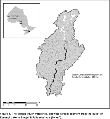
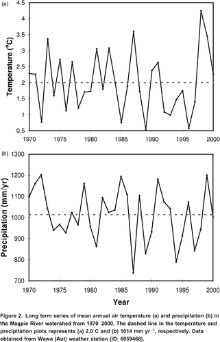
The natural flow of the Magpie River has been heavily altered by several control structures along its flow path. There are four dams and three hydroelectric power facilities along the entire course of the Magpie River of which the Steephill Falls reservoir station is the northernmost and also the largest reservoir station within the study site (Murchie and Smokorowski, Citation2004). The Steephill Falls reservoir extends 24 km upstream with a surface area of approximately 14 km2. Esnangi Lake (surface area = 46 km2) in the upper part of the watershed can provide additional water to Steephill Falls. Between 19702000 average annual air temperature and precipitation in the watershed was estimated to be ~2C and ~1000 mm, respectively ().
Figure 2. Long term series of mean annual air temperature (a) and precipitation (b) in the Magpie River watershed from 19702000. The dashed line in the temperature and precipitation plots represents (a) 2.0C and (b) 1014 mm yr1, respectively. Data obtained from Wawa (Aut) weather station (ID: 6059468).
Construction and operation of hydroelectric facilities on the Magpie River has resulted in a flow regime that deviates significantly from the natural hydrograph pattern. Thus the hydrological model developed in this study could not be calibrated on the Magpie River. Therefore, the Batchawana River (47012N, 843056W) was used as a reference watershed. The Batchawana River watershed (area = 1190 km2, average runoff = 621 mm yr1) was selected due to its proximity to the Magpie River watershed, hydrologic similarity, its relatively pristine state, and the availability of a long-term streamflow record from the Water Survey of Canada (WSC) stream gauge 02BF001 (Batchawana River near Batchawana) for the period 19702000.
Methods
Climate Downscaling
Meteorological time series of observed precipitation and temperature between 1970 and 2000 () were used to downscale the CGCM3 to local Magpie River watershed conditions. The downscaling process serves as a bridge that links GCM outputs to local scale atmospheric variables. However, large uncertainties are still associated with climate downscaling. For example, CGCM3 variables are at global scale but there might be divergent responses at local or regional scales caused by geomorphologic or landscape differences (Franczyk and Chang, Citation2009). As a result, several downscaling techniques have been developed, each having their strengths and weaknesses (Fowler et al., Citation2007). These include weather typing techniques (e.g., Paredes et al., Citation2006), stochastic weather generators (e.g., Semenov and Barrow, Citation1997), dynamic downscaling (e.g., Murphy, Citation2000) and statistical downscaling (e.g., Freybuness et al., Citation1995; Murphy, Citation2000; Wilby et al., Citation2002; Dibike and Coulibaly, Citation2005).
The Statistical Downscaling Model (SDSM) (Wilby et al., Citation2002; Wilby and Dawson, Citation2007) was used in this study. The SDSM is a statistical downscaling tool which combines regression-based and stochastic weather generation techniques to simulate local meteorological conditions from CGCM3 outputs. An empirically estimated statistical relationship between CGCM3 predictors and local predictand (Wilby et al., Citation2002) is then used to generate an ensemble of projected meteorological time series representative of future climate scenarios.
To calibrate the SDSM, a thirty-one year (19702000) time series of observed meteorological data from Wawa (Aut) weather station (ID: 6059408) () and predictor series from the National Centers for Environmental Prediction (NCEP) reanalysis data were used. The first stage of calibration involved a quality control check on the predictand variables in SDSM. This was done to check for inconsistency in the weather series. NCEP reanalysis data were then screened for statistical relationships with the observed meteorological data. NCEP reanalysis data represent the present day climate in the region; therefore predictand series ending in year 2000 were used for downscaling.
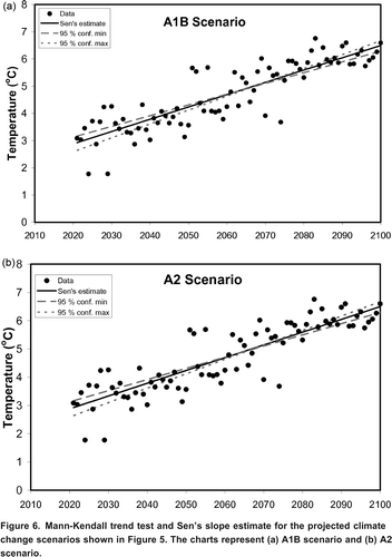
The calibrated statistical relationships between NCEP and observed time series were then used to project future climate (under objective A1B and A2 scenarios) after the introduction of stochasticity. CGCM3 variables were acquired from the Data Access Integrator (DAI portal) of Environmental Canada (EC). CGCM3 is run based on the IPCC A1B and A2 emission scenarios. The A1B and A2 scenarios represent two of the four IPCC emission scenarios described in the Special Report on Emission Scenario (SRES). Each of the scenarios describes a hypothetical storyline with increasing world population and technological advancement that decline toward the end of the 21st century (Solomon et al., Citation2007). However, both scenarios differ in their global (A1B) and regional (A2) focus. Both the historical predictand as well as the A1B and A2 scenario series generated were subjected to the Mann-Kendall (MK) Test and Sen's Slope Estimates to determine the trend in the annual data (MAKESENS 1.0) (Salmi et al., Citation2002).
Modelling Platform
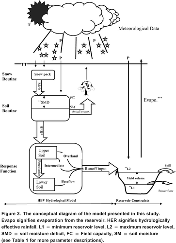
The model structure for simulating reservoir stage and operational constraints in place at Steephill Falls () were developed using STELLA software (ISEE Systems, Citation2009), an object-oriented, icon-based modelling and simulation software. The simulation-based model building block in STELLA (e.g., stock, flow, converter, reservoir, etc.) is equipped with hierarchical modelling systems at the model, equation and interface layers. At the model layer, structures are developed by connecting predefined building blocks, which are translated to numerical equations at the equation layer (Costanza and Voinox, Citation2001). Model simulations were performed using the Euler numerical integration technique in STELLA (e.g., Seppelt and Richter, Citation2005; ISEE Systems, Citation2009).
Figure 3. The conceptual diagram of the model presented in this study. Evapo signifies evaporation from the reservoir. HER signifies hydrologically effective rainfall. L1 = minimum reservoir level, L2 = maximum reservoir level, SMD = soil moisture deficit, FC = Field capacity, SM = soil moisture (see Table 1 for more parameter descriptions).
Hydrological Model Component
The HBV rainfall-runoff model was used to generate runoff time series for the reservoir sub-model. The HBV model simulates daily runoff time series from inputs of temperature and precipitation data (Bergstrm et al., Citation1992; Lindstrm et al., Citation1997). This is necessary for runoff projection under climate change scenarios or when the model is applied to sites with limited or no runoff data (Oni et al., Citation2011). The conceptual framework of the HBV rainfall-runoff model is based on and on the general water balance principle:
where P is precipitation (mm), E is evapotranspiration (mm), R is the total runoff depth from the catchment (mm), and S is the change in water/snow storage (mm).
HBV can be described as a physically-based, semi-distributed, rainfall-runoff model of moderate computational complexity (e.g., Lindstrm and Harlin, Citation1992; Menzel and Brger, Citation2002). HBV has been a useful resource tool for runoff and flood forecasting, spillway design (e.g., Bergstrm et al., Citation1992), nutrient load estimates (e.g., Arheimer and Wittgren, Citation1994), climate and land use changes (e.g., Hundecha and Brdossy, Citation2004; Seibert and McDonnell, Citation2010) and also in conjunction with water quality models (e.g., Futter et al., Citation2007; Oni et al., Citation2011, Citation2012).
Running HBV requires a daily time series of air temperature T (C) and P as well as observed R time series for model calibration. The model is based on routines for snow accumulation and melt, influence of soil moisture on runoff generation and a runoff response routine (). The parameter TT (Threshold Temperature) was used to partition precipitation into either rainfall or snowfall. Maximum soil water capacity was represented as FC (Field Capacity). Snowmelt is simulated by the degree day method (e.g., Lindstrm et al., Citation1997; Seibert and McDonnell, Citation2010). The parameter BETA regulates soil moisture contribution to runoff and hydrologically effective rainfall (HER) denotes the net precipitation that can infiltrate the soil either as rainfall or snowmelt (excluding evapotranspiration). More information about the model development and application of this STELLA-based version elsewhere in Canada can be found in Oni et al. (Citation2011, Citation2012) while more detailed information about the HBV rainfall-runoff model (, ) is available elsewhere (e.g., Lindstrm and Harlin, Citation1992; Saelthun, Citation1996; Lindstrm et al., Citation1997; Seibert, Citation2002; Seibert and McDonnell, Citation2010).
Table 1. Model parameter values and definitions for the Batchawana River and Steephill Falls reservoir constraints.
The HBV model was calibrated on the Batchawana River (where there are no hydropower reservoirs or control structures) using data from September 2004 to December 2009. The HBV model parameters estimated during calibration to the Batchawana River were applied to the Magpie River watershed so as to simulate a potential natural runoff regime that we hypothesize would have been observed in the absence of control structures. Magpie River flows were estimated so as to provide the necessary runoff inputs for the reservoir sub-model for future climate change projections.
Assessments of model fit were estimated using the Nash-Sutcliffe (NS) statistic to evaluate the quantitative performance of the model in sequencing runoff and reservoir stage relative to the observed data (see EquationEquation 4). The NS statistic ranges from 1 to -. A value of 1 indicates a perfect fit while a value of 0 indicates the model predictions are as accurate as the mean of the observed data (Nash and Sutcliffe, Citation1970; Krause et al., Citation2005).
Reservoir Model Component
The development of the reservoir sub-model was based on generic reservoir routing water input-output principles (e.g., Fenton, Citation1992):
where S is the volume of water (m3) in the reservoir at time t (s), I is the inflow to the reservoir (m3 s1) and is the reservoir outflow (m3 s1) at time t.
could also include lake evaporation or water extraction from the reservoir for other purposes but those processes are not included in this version of the model. The runoff time series used as inputs into the reservoir model can be either direct streamflow observation or simulated/projected streamflow from the HBV model. Parameters in the reservoir model () include initial reservoir volume (Vo), minimum (V1) and maximum (V2) reservoir capacity (m3). Both the L1 (masl) and L2 (masl) represent minimum reservoir level and maximum reservoir level, respectively (). The model uses these parameters to calculate the reservoir yield volume (). Yield volume represents the storage volume of water available for power generation and is a function of the input-output water balance of the reservoir model.
Due to a lack of bathymetric information, changes in reservoir yield or storage volumes were converted to reservoir levels, assuming a linear relationship in the Steephill Falls reservoir elevation-volume rating curve from L1 to L2 (EquationEquation 3). Between the L1 and L2 is the reservoir yield depth of 6 m. This represents a total storage capacity of ~110 106 m3 after which excess water is estimated as spill volume. Reservoir water level fluctuation is a function of reservoir inflows and the magnitude, timing, and duration of flows released downstream of the Steephill Falls hydropower facility. These flows are governed by operational constraints on both reservoir water levels (i.e., L1 and L2). Therefore the reservoir model was constrained based on minimum and maximum outflows of 7.5 m3 s1 and 44.5 m3 s1, respectively, and the assumed reservoir ruling curve between L1 and L2 (EquationEquation 3
).
where level (masl) is the reservoir yield depth (masl) and storage volume (m3) is the function of yield volume (m3) between L1 and L2 () that resulted from the water input-output balance of the reservoir for hydropower production.
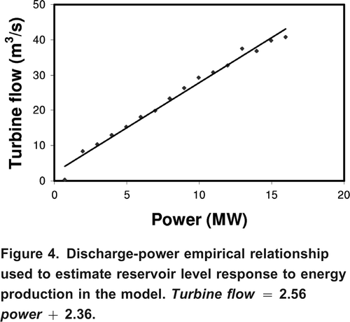
Reservoir level data from June 2004 to December 2005 was used in the model calibration. To project how the reservoir might respond to future climate change, the projected air temperature and precipitation series downscaled using SDSM were used with HBV to simulate runoff inputs to the reservoir. Plausible hypothetical energy demand scenarios in the future were assessed using a simple empirical turbine flow-power generation relationship (). The model was assessed using NS statistics:
Figure 4. Discharge-power empirical relationship used to estimate reservoir level response to energy production in the model. Turbine flow = 2.56power + 2.36.
where (m3 s1) is the observed discharge on the Batchawana River (or reservoir level in case of reservoir simulation),
(m3 s1) is the simulated discharge (or reservoir level respectively) and
(m3 s1) is the mean of the observed discharge (or reservoir level).
Results
Climate Data and Analysis
Long term mean air temperature and precipitation (19702000) in the Magpie River watershed was 2.0C and 1014 mm yr1, respectively (). Though no statistically significant trend was detected in the thirty-one year series, there is an increase in the magnitude of variability toward the end of the observational record. The variability in the thirty-one year historical weather can be described as intermittent and alternating warm-dry regimes, warmer-wetter regimes, cool-dry regimes as well as a very warm-wet period ending in 2000 (). These changes in the magnitude of variability in the historical weather serve as a pointer of long term changes in the future ().
Figure 5. Result of CGCM3 downscaling, showing non-homogeneity in future air temperatures under IPCC (a) A1B; dashed line = 3.6C, solid line = 4.9C (b) A2 scenarios; dashed line = 3.7C, solid line = 5.7C.
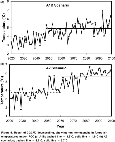
Future climate projections in the Magpie River watershed showed a significantly increasing trend in air temperature under both the A1B (MK = 6.49) and A2 (MK = 8.95) climate scenarios () at p < 0.001. Both scenarios suggest that average annual air temperature in the Magpie River region might rise to 3.5C and 3.7C, respectively, by the middle of the 21st century (). This represents a 1.5C to 1.7C increase over the historic average ending in the year 2000 (). Both scenarios also project further increases in air temperature reaching 4.9C and 5.7C for A1B and A2 scenarios, respectively, towards 2100 (). This represents a 2.9C to 3.7C increase relative to the historical temperature series where mean annual temperature was only 2.0C ().
Figure 6. Mann-Kendall trend test and Sen's slope estimate for the projected climate change scenarios shown in . The charts represent (a) A1B scenario and (b) A2 scenario.
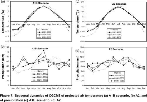
On the seasonal scale, both the A1B and A2 scenarios were very similar (). Both climate scenarios showed warmer winters and springs relative to the historical record as well as colder autumns. However, the scenarios were in close agreement with the observed values in the summer where July was identified as the warmest month under present and future scenarios (). Unlike temperature (), no significant trend was detected in the projected long term precipitation series (not shown) but useful information can be inferred from the variability of the projected precipitation on a seasonal scale (). Both A1B and A2 scenarios projected higher precipitation relative to the historical record except in autumn. The largest variability was observed in the 20212030 time period under both scenarios.
Figure 7. Seasonal dynamics of CGCM3 of projected air temperature (a) A1B scenario, (b) A2, and of precipitation (c) A1B scenario, (d) A2.
Modelling Analysis
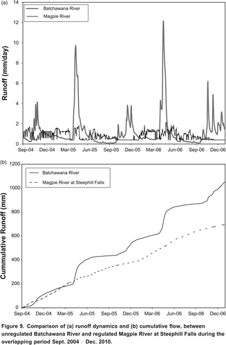
Presence of control structures such as reservoirs on a water course alters the pristine hydrograph pattern. This is evident when comparing runoff hydrographs between the altered Magpie River and natural Batchawana River () and differences in cumulative runoff depth using the overlapping period of 20042006 in the two data series (). The HBV model performed well in simulating the inter-annual flow patterns in the Batchawana River (). However, the model could not capture all runoff peaks. As a result, the model underestimated some of the extreme events as well as some baseflow regimes ().
Figure 8. Discharges rate in (a) the regulated Magpie River from 20012006 and (b) the non-regulated Batchawana River from 20042009 in comparison to HBV simulated streamflow (NS = 0.68).
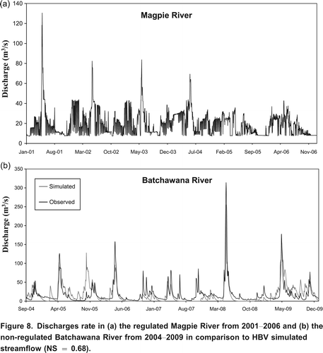
Figure 9. Comparison of (a) runoff dynamics and (b) cumulative flow, between unregulated Batchawana River and regulated Magpie River at Steephill Falls during the overlapping period Sept. 2004 Dec. 2010.
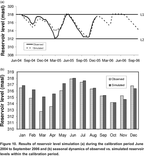
The reservoir sub-model also performed fairly well in simulating the inter-annual and seasonal reservoir water level dynamics during the calibration period (). However, the model could not capture some of the reservoir drawdown in 2005 and overestimated the drawdown in 2004. The error of overestimation was more pronounced in the winter and spring seasons than summer and autumn (). The reservoir simulation was in closer agreement with observations in the autumn than other seasons.
Figure 10. Results of reservoir level simulation (a) during the calibration period June 2004 to September 2006 and (b) seasonal dynamics of observed vs. simulated reservoir levels within the calibration period.
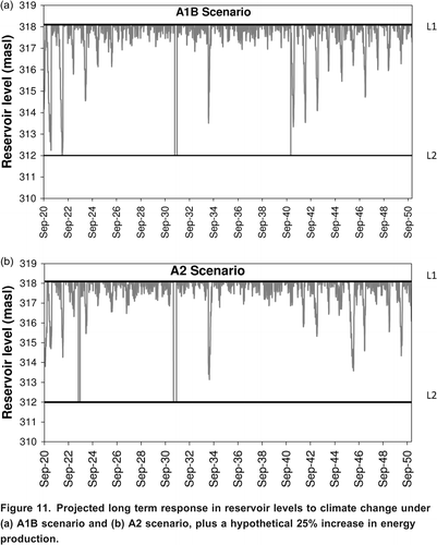
The calibrated functions () allow the prediction of reservoir responses under the future IPCC A1B and A2 scenarios in combination with a hypothetical 25% (for example) increase in energy demand. Under the combination of 25% hypothetical energy increase and climate change scenario (), model results suggested more drawdown at the beginning of the projected record. This subsided midway in the projected record period and more drawdown towards the end of record. A1B projected more drawdown depth than A2 scenario toward the end of record ().
Figure 11. Projected long term response in reservoir levels to climate change under (a) A1B scenario and (b) A2 scenario, plus a hypothetical 25% increase in energy production.
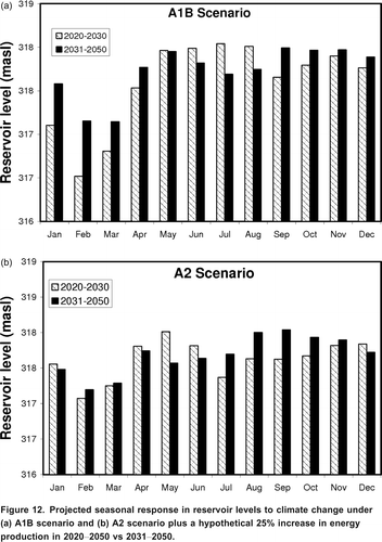
When the thirty-one year projection period was sub-divided into 20202030 and 20312050 and compared on a monthly scale, some differences can be inferred between the two scenarios (). Both scenarios showed reservoir drawdown in winter (FebruaryMarch). The model projected high reservoir levels following winter in A1B but further drawdown in summer following spring melt (20202030) under the A2 scenario. Winter drawdown in the 20312050 window was more intense than the 20312050 period under the A1B scenario whereas both periods are similar under the A2 scenario. Model projections suggest higher reservoir water levels in the A1B relative to the A2 scenarios in the future ().
Figure 12. Projected seasonal response in reservoir levels to climate change under (a) A1B scenario and (b) A2 scenario plus a hypothetical 25% increase in energy production in 20202050 vs 20312050.
Discussion
The Changing Weather and Climate
Climate is the dominant driver of watershed hydrological processes including runoff (e.g., Marshall and Randhir, Citation2008). Runoff is important for maintaining ecological processes and resilience as well as controlling dissolved oxygen, sediment and water temperature (Arthington et al., Citation2006; Freeman et al., Citation2001). The magnitude of streamflow response to future climate change might be difficult to accurately project due to possible interaction of other human factors. No detectable trend was observed in the historical air temperature and precipitation used as a baseline period () but useful inferences can be drawn from the increasing weather variability toward the year 2000 (). Interannual variability in precipitation and watershed climatic condition can cause large variation in streamflows under different hydrologic regimes. The increasing magnitude of variability observed in the historical data and intensification of the intermittent dry-wet regimes show the sensitivity of the Magpie River region to the possible effect of climate change.
Previous studies have also shown that climate change will have impacts in Northern Ontario and Canada as a whole (Filion, Citation2000; Serreze et al., Citation2000; Westmacott and Burn, Citation1997; Mortsch and Quinn, Citation1996). The effects of this on the watershed hydrological cycle will include changes to the amount and timing of runoff. Runoff is expected to increase in higher latitude watersheds in the future (Renfalt et al., Citation2010; Serreze et al., Citation2000), leading to more water inputs into reservoirs. While these will have ecological implications (Magnuson et al., Citation1997; Schindler et al., Citation1996; Armitage et al., Citation1987), this might be advantageous for hydropower production and to meet the water needs of other values. Therefore, climate impacts on hydropower reservoir water storage capability might be an issue in the future (e.g., Vicuna et al., Citation2008; Filion, Citation2000).
The projected significant increases in temperature and change in precipitation in the Magpie River watershed under both climate scenarios might suggest greater evapotranspiration in the future. The climate projections suggest that regional future climate conditions in the Magpie River might get warmer and that the magnitude of variability may increase towards the end of the 21st century. The temperature rise of about 1.51.9C will be large in a watershed such as the Magpie River with a historical long term mean of only 2.0C. This result is in line with other studies (e.g., Mimikou et al., Citation1991; Serreze et al., Citation2000) that winter might become shorter and warmer in the future and this might reduce areal snow cover in the region.
Although there was no detectable trend in the projected long term precipitation series, valuable insights can be derived from the seasonal evaluation from this study's model projections. Projected warmer spring temperatures suggest that there might be earlier and faster snowmelt in the future. Snowfall dominance that characterized winter seasons might also shift toward rainfall dominance. This will present new challenges for hydropower production that depends on stored snowmelt water for redistribution to other seasons. The future climate in the Magpie River watershed can therefore be best summarized as a mix of warmer-wetter winter, wetter summer and cooler-drier autumn (). This makes the overall long term projected trend of the watershed to tend toward warmer-wetter conditions throughout the 21st century. This will have effects on the watershed water balance and the occurrence of extreme events (Middelkoop et al., Citation2001; Menzel and Burger, Citation2002; Booij, Citation2005).
Model Simulations
The HBV rainfall-runoff model performed well in simulating the inter-annual flow pattern in Batchawana River with NS value of 0.60. The model could not capture some of the seasonal extremes and some baseflow periods (). This shows that some hydrological processes pertinent to this northern region were not adequately captured in the calibration presented here. However, the application of the HBV was successful enough to generate runoff conditions to fulfill the hydrological objective of this study. Previous application of this model in a southern Ontario watershed and in conjunction with other biogeochemical models had proven successful (Oni et al., Citation2011, Citation2012). The success of HBV in simulating runoff in the Batchawana River therefore allowed us to simulate what the natural runoff would have been in the altered Magpie River. Thus, the necessary natural runoff inputs into the reservoir under the objective climate change scenarios could be simulated, using the operational constraints in to mimic reservoir dynamics at Steephill Falls.
The application of the reservoir submodel in simulating reservoir level dynamics at this hydropower facility was good, with a NS value of 0.87 (). Reservoir drawdown in the winter of 2005 could not be fully accounted for as the model overestimated the reservoir level especially between February and May. However, the model simulation was in agreement with observed reservoir level during the summer months when reservoir stage and volume were at their highest. This is explained by Steephill Falls being operated as a peaking station where the reservoir is primarily used to store water from spring snowmelt and higher autumn flows for hydropower generation in the summer and winter seasons, respectively. In addition to the seasonal redistribution of flow volume, peaking operations also result in increasing frequency of low flows during the weekends when water is conserved in the reservoir for optimal energy production during the week.
Implication on Hydropower Reservoir and Trade-off for Other Values
Hydropower is one of the single largest water users and a renewable source of energy production (Frey and Linke, Citation2002). Since electricity cannot be stored, energy demand must be complemented by immediate power production (Egr and Milewski, Citation2002). Therefore hydropower reservoirs will always remain vulnerable to future climate changes (Schaefli et al., Citation2007; Robinson, Citation1997) amidst other competing water interests (Schaeffer and Szklo, Citation2001; Cordell and Bergstrom, Citation1993). This vulnerability and associated conflicts may increase with increasing demand for economic development, social and environmental protection (Renflt et al., Citation2010; Cordell and Begstrom, Citation1993). Thus, future hydropower reservoir management hinges on a delicate balance with respect to climate, which controls water supply to reservoirs, energy demand, and water management practices, which control water availability and distribution to satisfy other environmental, social, and recreational objectives. Striking a sustainable balance between competing socioeconomic objectives and ecosystem water requirements may be particularly challenging (Poff et al., Citation2003; Schaeffer and Szklo, Citation2001).
While climate change might have a long-term effect (Schaefli et al., Citation2007), flow management strategies resulting from hydropower peaking will have an immediate impact on reservoir water levels and downstream flows (Palmer et al., Citation2008; Moog, Citation1993). Hydropower reservoir peaking impact hydrological mechanisms such as the magnitude, frequency, timing, duration and rate of change of river flow (Renflt et al., Citation2010). This study's results show that the future climate in the Magpie River region might tend toward warmer and wetter conditions with increased runoff inputs to the reservoir. The projected increases in precipitation will induce high runoff at the upstream and downstream reaches (Renflt et al., Citation2010; Jager and Smith, Citation2008; Gore et al., Citation1989; Shield et al., Citation2000; Magnuson et al., Citation1997; Power et al., Citation1996; Schindler et al., Citation1996). Increased winter rainfall dominance may lessen the need for large reservoir drawdown in winter. Also, the decreased storage capability at spring melt may be offset by smaller runoff volumes at this time but possibly provide opportunities to pass higher magnitude, ecologically-important flows to maintain heterogeneity of the channel structure and re-connect the river to its riparian areas.
Increased summer flows could buffer future extreme events associated with drier and hotter conditions, allowing both the production of hydropower while satisfying downstream environmental baseflow requirements. However, ecological effects of increased peaking frequency during the summer may counterbalance any positive effects of increased baseflow (Renflt et al., Citation2010; Smokorowski et al., Citation2010). Whatever the outcome, the present minimum environmental flow of 7.5 m3 s1 downstream of Steephill Falls waterpower facility might need to be modified in the future. This will help to mitigate the new ecological demands (e.g., Smokorowski et al., Citation2010; Arthington et al., Citation2006) and opportunities for re-naturalizing some components of the natural runoff hydrograph (Galat and Lipkin, Citation2000) that existed before the construction of the reservoir since it is practically impossible to fully reinstate the original condition of the river and natural runoff variability.
Despite the hypothetical 25% increase in energy demand on the reservoir, the model scenarios suggest high reservoir levels. This suggests that the potential for hydropower production in northern regions will increase as a result of increased runoff in the future (Lehner et al., Citation2005). Increased runoff projections appear to counteract the effect of any possible increase in power production at the study site, possibly increasing spillage or an increase in the redistribution of flows and therefore of power generation.
Warmer air temperatures might also lead to an increase in evapotranspiration (Robinson, Citation1997; Brooks et al., Citation2003). Water loss through this hydrological mechanism might be significant on large reservoirs such as Steephill Falls with surface area of ~24 km2 and from its predominantly forested watershed. This is evidenced in the results where large differences existed between the cumulative flow in the unregulated Batchawana River and highly altered Magpie River using the same time period (). This reservoir evaporation might be large on annual scale depending on the number of windy and dry days that occurred during the ice-free period. This similar trend might continue in the future as climate changes and the number of other end users increase. Regions with a potentially drier climate in the future are particularly important to identify as current waterpower facilities and potential waterpower sites may become uneconomically viable, especially if the water to meet other objectives are to be maintained simultaneously with new energy demands. This may counteract the effects of climate-induced runoff increase in future.
Model Uncertainty
While there is an ongoing effort in the scientific communities to reduce the uncertainties in global climate projection, large gaps still exist in our understanding of the impact of climate change and the simultaneous impacts of other climate dependent factors on hydropower reservoir dynamics in the future. While initial application of this model has proven successful to understand future reservoir responses, several assumptions were made and model uncertainty is still large. Some levels of uncertainty might be attributed to the downscaling of the CGCM3 to watershed conditions and the choice of downscaling technique. The statistical downscaling method used in this study utilizes a regression based approach which can only account for a fraction of the total CGCM3 variations. The implication of this is that some future extremes might have underestimated. Errors from the statistical functions might have been transferred into the future projections. While downscaling temperature data might be better due to better correlation between local air temperature and global scale atmospheric predictors, large uncertainty exists in precipitation downscaling using this method. Also, the choice of using CGCM3 in this study over other types of climate models might also contribute to the uncertainty in the climate projections. Preferably, hydrological projections using an ensemble of simulations from different climate models (e.g., Khon et al., Citation2012; Weiland et al., Citation2012; Bergstrm et al., Citation2001) would have reduced the uncertainty of using only CGCM3 projections at the study site.
Calibration functions from the Batchawana River were assumed to simulate the natural flow regime in the Magpie River; in reality hydrological processes for the two headwater catchments might be different between the two watersheds. This might result in large uncertainty but this approach was used in the absence of natural flow time series from the Magpie River to use for model calibration. More credence would have been given to the results if historic pre-construction and post-construction data on Magpie River and Steephill Falls had been obtained instead of using Batchawana River as the hydrological reference. Access to such data could have improved our understanding of the basic hydrological responses of the watershed to weather conditions under undisturbed condition and reduce the magnitude of error associated with this study's climate change modelling and projections.
While both the Magpie and Batchawana watersheds are in the same geographical location and might have similar attributes such as bedrock geology, topography and land cover, their orientation to Lake Superior can introduce contrasting local weather conditions that might result in large differences in the hydrological responses of the two watersheds. These contrasting local weather conditions between the two watersheds might include the onset and duration of ice-free period, duration and intensity of summer precipitation events in winter or summer months, and relative humidity.
Another major assumption made was the linearity of the reservoir elevation-discharge rating curve from L1 to L2 (see ) in the absence of bathymetric data but this might not be realistic. The use of simple one-dimensional energy-flow relationship () on annual scale introduced large errors since energy generation depends on the combination of several limiting factors such as climate, stream inflows, storage capacity and hydraulic head at different seasons and hydrologic regimes of a year. While these sources of errors and assumptions were identified as the shortcoming of the initial model application, this model can be further improved to be a useful tool that can be used to evaluate the impacts of climate and flow management on hydroelectric power reservoir dynamics. Further modifications and inclusions of other components such as a more efficient reservoir ramping routine to meet variability in seasonal (winter/summer) and daily (day/night, weekday/weekend) energy demands and plausible economic sub-models are necessary to make the model a more effective decision-making tool.
Conclusion
Hydropower reservoir management involves trade-offs between economic objectives of meeting new and future energy demands and providing environmental flows to sustain the ecological integrity of the downstream systems as well as flows and levels for other social and recreational values whilst responding to the variability inherent in climate induced catchment runoff inputs to the reservoir (Renflt et al., Citation2010; Palmer et al., Citation2008). This governance hinges on a delicate balance between sometimes conflicting social, ecological and economic objectives that will affect decision-making processes (Ngo et al., Citation2008; Schaeffer and Szklo, Citation2001).
The presence of hydropower reservoirs on rivers alters natural flow patterns, which is an important driver of biogeochemical and ecological processes. Therefore changes to flow regimes for hydropower generation, the single largest user of water due to the high volume of water required to generate electricity, will have large impacts on aquatic ecosystems. Policies and guidelines exist in Ontario for hydropower operators to evaluate their management methodologies so as to balance their environmental and socioeconomic impact on river systems. However, climate change as well as population-driven energy demand will result in complex responses on hydrological and hydropower reservoir systems. As a result, maintaining the balance between energy production and other environmental, social, and recreational values might become increasingly challenging with climate change. Therefore, continuous research efforts including modelling will help to further updating some of the existing guidelines and to explore what-if scenarios so that effective mitigation strategies can be implemented against possible futures.
Acknowledgements
The authors would like to acknowledge the Data Access Integration (DAI) team for providing the CGCM3 predictor data used in this study. The DAI data download gateway is made possible through collaboration among the Global Environmental and Climate Change Centre (GEC3), the Adaptation and Impacts Research Division (AIRD) of Environment Canada, and the Drought Research Initiative (DRI). Environment Canada (EC) provided weather and flow data. This project was supported by an OMNR grant to PD. The editorial assistance of Hayla Evans on the earlier version of the manuscript is greatly appreciated.
References
- Andersson , E. C. , Freeman , M. C. and Pringle , C. M. 2006 . Ecological consequences of hydropower development in Central America: Impacts of small dams and water diversion on neotropical stream fish assemblage . River Research and Application , 22 : 397 – 411 .
- Arheimer , B. and Wittgren , H. B. 1994 . Modelling the effects of wetlands on regional nitrogen transport . Ambio , 23 : 378 – 386 .
- Armitage , P. D. , Gunn , R. J. M. , Furse , M. T. , Wright , J. F. and Moss , D. 1987 . The use of prediction to assess macroinvertebrate response to river regulation . Hydrobiologia , 144 : 25 – 32 .
- Arthington , A. H. , Bunn , S. E. , Poff , N. L. and Naiman , R. J. 2006 . The challenge of providing environmental flow rules to sustain river ecosystems . Ecological Applications , 16 : 1311 – 1318 .
- Bakis , R. 2007 . Electricity production opportunities from multipurpose dams (case study) . Renewable Energy , 32 : 1723 – 1738 .
- Bergstrm , S. , Harlin , J. and Lindstrm , G. 1992 . Spillway design floods in Sweden I. New guidelines . Hydrological Sciences Journal , 37 : 505 – 519 .
- Bergstrm , S. , Carlsson , B. , Gardeling , M. , Lindstrm , G. , Pettersson , A. and Rummukainen , M. 2001 . Climate change impacts on runoff in Sweden: Assessments by global climate models, dynamical downscaling and hydrological modelling . Climate Research , 16 : 101 – 112 .
- Booij , M. J. 2005 . Impact of climate change on river flooding assessed with different spatial model resolutions . Journal of Hydrology , 303 : 176 – 198 .
- Brooks, K. N., P. F. Ffolliot, H. M. Gergersen, and L. F. DeBano. 2003. Hydrology and the management of watersheds. Iowa City: Wiley-Blackwell Publisher, 574 pp.
- Cordell , H. K. and Bergstrom , J. C. 1993 . Comparison of recreation use values among alternative reservoir water level management scenarios . Water Resources Research , 29 : 247 – 258 .
- Costanza , R. and Voinov , A. 2001 . Modeling ecological and economic systems with STELLA: Part III . Ecological Modelling , 143 : 1 – 7 .
- Demirbas , A. 2007 . Focus on the world: Status and future of hydropower . Energy Sources Part B: Economic Planning and Policy , 2 : 237 – 242 .
- Dibike , Y. B. and Coulibaly , P. 2005 . Hydrologic impact of climate change in the Saguenay watershed: Comparison of downscaling methods and hydrologic models . Journal of Hydrology , 307 : 145 – 163 .
- Dynesius , M. and Nilsson , C. 1994 . Fragmentation and flow regulation of river systems in the northern third of the world . Science , 266 : 753 – 762 .
- Egr , D. and Milewski , J. C. 2002 . The diversity of hydropower projects . Energy Policy , 30 : 1225 – 1230 .
- Fenton , J. D. 1992 . Reservoir routing . Hydrological Sciences Journal , 37 : 233 – 246 .
- Filion , Y. 2000 . Climate change: Implications for Canadian water resources and hydropower production . Canadian Water Resources Journal , 25 : 255 – 270 .
- Fowler , H. J. , Blenkinsop , C. and Tebaldi , C. 2007 . Linking climate change modelling to impacts studies: Recent advances in downscaling techniques for hydrological modelling . International Journal of Climatology , 27 : 1547 – 1578 .
- Franczyk , J. and Chang , H. 2009 . The effects of climate change and urbanization on the runoff of the Rock Creek basin in the Portland metropolitan area, Oregon, USA . Hydrological Sciences Journal , 23 : 805 – 815 .
- Freeman , M. C. , Bowen , Z. H. , Bovee , K. D. and Irwin , E. R. 2001 . Flow and habitat effects on juvenile fish abundance in natural and altered flow regimes . Ecological Applications , 11 : 179 – 190 .
- Frey , G. W. and Linke , D. J. 2002 . Hydropower as a renewable and sustainable energy resource meeting global energy challenges in a reasonable way . Energy Policy , 30 : 1261 – 1265 .
- Freybuness , F. , Heimann , D. and Sausen , R. 1995 . A statistical-dynamical downscaling procedure for global climate simulations . Theoretical and Applied Climatology , 50 : 117 – 131 .
- Futter, M. N., D. Butterfield, B. J. Cosby, P. J. Dillon, A. J. Wade, and P. G. Whitehead. 2007. Modeling the mechanisms that control in-stream dissolved organic carbon dynamics in upland and forested catchments. Water Resources Research 43: W02424. doi:10.1029/2006WR004960.
- Galat , D. L. and Lipkin , R. 2000 . Restoring ecological integrity of great rivers: Histograph hydrographs aid in defining reference conditions for Missouri River . Hydrobiologia , 422 : 29 – 48 .
- Gore , J. A. , Nestler , J. M. and Layzer , J. 1989 . Instream flow predictions and management options for biota affected by peaking-power hydroelectric operations . Regulated Rivers: Research & Management , 3 : 35 – 48 .
- Heathcote, I. W. 2009. Integrated watershed management: Principles and practice. Hoboken, New Jersey: Wiley-Blackwell, 464 pp.
- Hundecha , Y. and Brdossy , A. 2004 . Modeling of the effect of land use changes on the runoff generation of a river basin through parameter regionalization of a watershed model . Journal of Hydrology , 292 : 281 – 295 .
- Intergovernmental Panel on Climate Change (IPCC). 2001. Climate change 2001: Impacts, adaptation, and vulnerability. Contribution of the Working Group II to the Third Assessment Report of the IPCC. Cambridge, UK and New York, USA: Cambridge University Press, 1005 pp.
- ISEE Systems. 2009. Software reference guide. STELLA software technical documentation. Lebanon, U.S.A.: ISEE Systems, 95 pp.
- Jager , H. I. and Smith , B. T. 2008 . Sustainable reservoir operation: Can we generate hydropower and preserve ecosystem values? . River Research and Applications , 24 : 340 – 352 .
- Jansson , R. , Nilsson , C. and Renfalt , B. 2000 . Fragmentation of riparian floras in rivers with multiple dams . Ecology , 81 : 899 – 903 .
- Khon , V. C. and Mokhov , I. I. 2012 . The hydrological regime of large river basins in Northern Eurasia in the XX XXI centuries . Water Resources , 39 : 1 – 10 .
- Krause , P. , Boyle , D. P. and Bse , F. 2005 . Comparison of different efficiency criteria for hydrological model assessment . Advances in Geosciences , 5 : 89 – 97 .
- Lehner , B. , Czisch , G. and Vassolo , S. 2005 . The impact of global change on the hydropower potential of Europe: A model-based analysis . Energy Policy , 33 : 839 – 855 .
- Lindstrm , G. and Harlin , J. 1992 . Spillway design floods in Sweden: II. Applications and sensitivity analysis . Hydrological Sciences Journal , 37 : 521 – 539 .
- Lindstrm , G. , Johansson , B. , Persson , M. , Gardelin , M. and Bergstrom , S. 1997 . Development and test of the distributed HBV-96 hydrological model . Journal of Hydrology , 201 : 272 – 288 .
- Magnuson , J. J. , Webster , K. E. , Assel , R. A. , Bowser , C. J. , Dillon , P. J. , Eaton , J. G. , Eavans , H. B. , Fee , E. J. , Hall , R. I. , Mortsch , L. R. , Schindler , D. W. and Quinn , F. H. 1997 . Potential effects of climate changes on aquatic systems: Laurentian Great Lakes and Precambrian shield region . Hydrological Processes , 11 : 825 – 871 .
- Marshall , E. and Randhir , T. 2008 . Effect of climate change on watershed system: A regional analysis . Climate Change , 89 : 263 – 280 .
- Menzel , L. and Burger , G. 2002 . Climate change scenarios and runoff response in the Mulde catchment (southern Elbe, Germany) . Journal of Hydrology , 267 : 53 – 64 .
- Middelkoop , H. , Daamen , K. , Gellens , D. , Grabs , W. , Kwadijk , J. C. J. , Lang , H. , Parmet , B. W. A. H. , Schdler , B. , Schulla , J. and Wilke , K. 2001 . Impact of climate change on hydrological regimes and water resources management in the Rhine basin . Climatic Change , 49 : 105 – 128 .
- Mimikou , M. , Kouvopoulos , Y. , Cavadias , G. and Vayianos , N. 1991 . Regional hydrological effects of climate change . Journal of Hydrology , 123 : 119 – 146 .
- Moog , O. 1993 . Quantification of daily peak hydropower effects on aquatic fauna and management to minimize environmental impacts . Regulated Rivers: Research and Management , 8 : 5 – 14 .
- Mortsch , L. D. and Quinn , F. H. 1996 . Climate change scenarios for Great Lakes basin ecosystem studies . Limnology and Oceanography , 41 : 903 – 911 .
- Murchie , K. J. and Smokorowski , K. E. 2004 . Relative activity of Brook Trout and Walleyes in response to flow in a regulated River . North American Journal of Fisheries management , 24 : 1050 – 1057 .
- Murphy , J. 2000 . Predictions of climate change over Europe using statistical and dynamical downscaling techniques . International Journal of Climatology , 20 : 489 – 501 .
- Nandalal , K. D. W. and Sakthivadivel , R. 2002 . Planning and management of a complex water resource system: Case of Samanalawewa and Udawalawe reservoirs in the Walawe River, Sri Lanka . Agricultural Water Management , 57 : 207 – 221 .
- Nash , J. E. and Sutcliffe , J. V. 1970 . River flow forecasting through conceptual models part IA discussion of principles . Journal of Hydrology , 10 : 282 – 290 .
- Ngo , L. L. , Madsen , H. , Rosbjerg , D. and Pedersen , C. B. 2008 . Implementation and comparison of reservoir operation strategies for the Hoa Binh reservoir, Vietnam using the MIKE 11 model . Water Resources Management , 22 : 457 – 472 .
- Nilsson , C. and Berggren , K. 2000 . Alterations of riparian ecosystems caused by river regulation . BioScience , 50 : 783 – 792 .
- Nilsson , C. , Reidy , C. A. , Dynesius , M. and Ravenga , C. 2005 . Fragmentation and flow regulation of the world's large river systems . Science , 308 : 405 – 408 .
- Oki , T. and Kanae , S. 2006 . Global hydrological cycles and world water resources . Science , 25 : 1068 – 1072 .
- Oni , S. K. , Futter , M. N. and Dillon , P. J. 2011 . Landscape-scale control of carbon budget of Lake Simcoe: A process-based modelling approach . Journal of Great Lakes Research , 37 : 160 – 165 .
- Oni , S. K. , Futter , M. N. , Molot , L. A. and Dillon , P. J. 2012 . Modelling the long term impact of climate change on the carbon budget of Lake Simcoe, Ontario using INCA-C . Science of the Total Environment , 414 : 387 – 403 .
- Palmer , M. A. , Reidy Liermann , C. A. , Nilsson , C. , Florke , M. , Alcano , J. , Lake , P. S. and Bond , N. 2008 . Climate change and the world's river basins: Anticipating management options . Frontiers in Ecology and the Environment , 6 : 81 – 89 .
- Paredes , D. , Trigo , R. M. , Garcia-Herrera , R. and Trigo , I. F. 2006 . Understanding precipitation changes in Iberia in early spring: Weather typing and storm-tracking approaches . Journal of Hydrometeorology , 7 : 101 – 113 .
- Poff , N. L. , Allan , J. D. , Palmer , M. A. , Hart , D. D. , Ritcher , B. D. , Arthinghton , A. H. , Rogers , K. H. , Meyer , J. L. and Stanford , J. A. 2003 . River flows and water wars: Emerging science for environmental decision making . Frontiers in Ecology and the Environment , 1 : 298 – 306 .
- Power , M. E. , Dietrich , W. E. and Finlay , J. C. 1996 . Dams and downstream aquatic biodiversity: Potential food web consequences of hydrologic and geomorphologic changes . Environmental Management , 20 : 887 – 895 .
- Renflt , B. M. , Jansson , R. and Nilsson , C. 2010 . Effects of hydropower generation and opportunities for environmental flow management in Swedish riverine ecosystems . Freshwater Biology , 55 : 49 – 67 .
- Robinson , P. J. 1997 . Climate change and hydropower generation . International Journal of Climatology , 17 : 983 – 996 .
- Saelthun, N. R. 1996. The Nordic HBV-model; description and documentation of the model version developed for the project-climate change and energy production. NVE Publication 7. Oslo: Norwegian Water Resources and Energy Administration, 26 pp. ISBN: 82 410 02 734.
- Salmi, T., A. Mtt, P. Anttila, T. Ruoho-Airola, and T. Amnell. 2002. Detecting trends of annual values of atmosphereric pollutants by the Mann-Kendall test and Sen's slope estimates The excel template application MAKESENS. Helsinki: Finish meteorological Institute, 35 pp.
- Schaefli , B. , Hingray , B. and Musy , A. 2007 . Climate change and hydropower production in the Swiss Alps: Quantification of potential impacts and related modelling uncertainty . Hydrology and Earth System Sciences , 11 : 1191 – 1205 .
- Schaeffer , R. and Szklo , A. S. 2001 . Future electric power technology choices of Brazil: A possible conflict between local pollutant and global climate change . Energy Policy , 29 : 355 – 369 .
- Schindler , D. W. , Bayley , S. E. , Parker , B. R. , Beaty , K. G. , Cruikshank , D. R. , Fee , E. J. , Schindler , E. U. and Stainton , M. P. 1996 . The effects of climate warming on the properties of boreal lakes and streams at the Experimental Lakes Area, Northwestern Ontario . Limnology and Oceanography , 41 : 1004 – 1017 .
- Seibert, J. 2002. HBV Light Manual. Version 2 ed. Sweden: Environmental Assessment; Swedish University of Agriculture, 16 pp.
- Seibert , J. and McDonnell , J. J. 2010 . Land-cover impacts on streamflow: A change-detection modelling approach that incorporates parameter uncertainty . Hydrological Sciences Journal , 55 : 316 – 332 .
- Semenov , M. A. and Barrow , E. M. 1997 . Use of a stochastic weather generator in the development of climate change scenarios . Climatic Change , 35 : 397 – 414 .
- Seppelt , R. and Richter , O. 2005 . It was an artefact not the result: A note on systems dynamic model development tools . Environmental Modelling and Software , 20 : 1543 – 1548 .
- Serreze, M. C., J. E. Walsh, F. S. Chapin III, T. Osterkamp, M. Dyurgerov, V. Romanovsky, W. C. Oechel, J. Morison, T. Zhang, and R. G. Barry. 2000. Observational evidence of recent change in the Northern high-latitude environment. Climatic Change 46: 159207.
- Shield , F. D. , Simon , A. and Steffen , L. J. 2000 . Reservoir effects on downstream river channel migration . Environmental Conservation , 27 : 54 – 66 .
- Solomon, S., D. Qin, M. Manning, Z. Chen, M. Marquis, K. B. Averyt, M. Tignor, and H. L. Miller (eds). 2007. The physical science basis. Contribution of working group I to the fourth assessment report of the intergovernmental panel on climate change. Cambridge, UK and New York, USA: Cambridge University Press, 996 pp.
- Smokorowski, K. E., R. A. Metcalfe, S. D. Finucan, N. Jones, J. Marty, M. Power, R. S. Pyrce, and R. Steele. 2010. Ecosystem level assessment of environmentally based flow restrictions for maintaining ecosystem integrity: A comparison of a modified peaking versus unaltered river. Ecohydrology. doi:10.1002/eco.167.
- Summer , W. , Stritzinger , W. and Zhang , W. 1994 . The impact of run-of-river hydropower plants on temporal suspended sediment transport behaviour . IAHS Publications-Series of Proceedings and Reports-International Association of Hydrological Sciences , 224 : 411 – 420 .
- Tundisi , J. G. , Rocha , O. , Matsumura-Tundis , T. and Braga , B. 1998 . Reservoir management in South America . International Journal of Water Resources Development , 14 : 141 – 155 .
- Vicuna , S. , Leonardson , R. , Hanemann , M. W. , Dale , L. L. and Dracup , J. A. 2008 . Climate change impacts on high elevation hydropower generation in California's Sierra Nevada: A case study in the Upper American River . Climatic Change , 87 : 123 – 137 .
- Vrsmarty , C. J. , Green , P. , Salisbury , J. and Lammers , R. B. 2000 . Global water resources: Vulnerability from climate change and population growth . Science , 289 : 284
- Weiland , F. C. S. , van Beek , L. P. H. , Weerts , A. H. and Bierkens , M. F. P. 2012 . Extracting information from an ensemble of GCMs to reliably assess future global runoff change . Journal of Hydrology , 412413 : 66 – 75 .
- Westmacott , J. R. and Burn , D. H. 1997 . Climate change effects on the hydrologic regime within the Churchill-Nelson River Basin . Journal of Hydrology , 202 : 263 – 279 .
- Wilby, R. L., and C. W. Dawson. 2007. SDSM 4.2-A decision support tool for the assessment of regional climate change impacts. UK: Loughborough University, 94 pp.
- Wilby , R. L. , Dawson , C. W. and Barrow , E. M. 2002 . SDSM-a decision support tool for the assessment of regional climate change impacts . Environmental Modelling & Software , 17 : 147 – 159 .