
ABSTRACT
Recent initiatives in geosciences education have focused on interactive and inquiry-based learning experiences both inside and outside of the classroom. While the concept is sound, examples and datasets seldom focus on opportunities to which the students can immediately relate. Herein we show how a university tradition has been transformed into an interactive geosciences learning opportunity for the university community. Each year during the third week of November, thousands of university students jump into an artificial pond on campus in support of the annual football rivalry game. An undergraduate student research initiative documenting the water quality of the pond before, during, and after the event clearly documents how humans can affect their environment. Use of the resulting dataset in the classroom for an entry-level geoscience laboratory exercise on water contamination has sparked student interest in the effects of anthropogenic activities on water quality and has mobilized subsequent studies to test additional hypotheses. Changes in students' attitudes on water quality were documented by significant differences in administered pre- and postexercise surveys with five-point Likert-type items, while subsequent interest in the dataset from both the university and the surrounding communities has provided additional audiences for engagement on local water contamination issues. Inclusion of the dataset into laboratory exercises is intended to lead to future research questions and promote independent research initiatives.
Key words::
Acknowledgments
We thank the following Ohio State students for their assistance with sample collection: Kelly Deuerling, Rachael Gray, Catherine Maxwell, Jeffrey Pigott, Daniel Reaman, Jameson Scott, and Jamey Stutz. We are also grateful to the Ohio State University Facilities Operations and Development and the City of Columbus Police Department for providing access to Mirror Lake before, during, and after the event.
FIGURE 1: Map of Mirror Lake. The east and west sampling points are denoted by an X. More than 90% of the jumpers were observed on the east side of the lake.
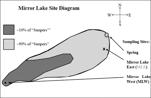
FIGURE 2: View of the east side of Mirror Lake during the peak hours of the event.
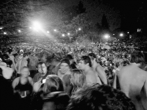
FIGURE 3: View of students sampling to the east side of Mirror Lake prior to the event.
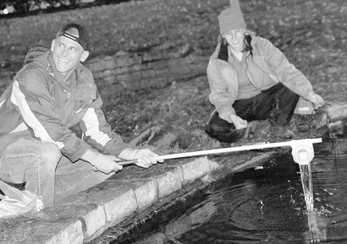
FIGURE 4: Differences in responses to paired questions.
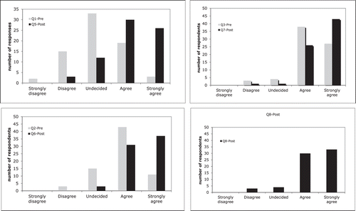
TABLE I: Concentrations of dissolved ions and nutrients in mirror lake.1,2
TABLE II: Future areas of inquiry and proposed testing methodology.1