
Abstract
The stratigraphic architecture of a thick (c. 9000 m) Albian–Recent sedimentary succession within the Pegasus Basin is presented here, based primarily on interpretation of the New Zealand Government's ‘PEG09’ 2D reconnaissance seismic survey. The basin lies immediately east and outboard of the Hikurangi subduction zone, and formed mainly because of Neogene downwarping of the underlying Pacific Plate near the transition from subduction to oblique-slip faulting. The basin fill is little deformed by the Neogene–Recent convergent margin tectonics that pervasively deform the adjacent East Coast Basin. Four large-scale tectonostratigraphic units are differentiated: (1) metasedimentary ‘basement’ rocks, deposited and accreted within the Gondwana Mesozoic accretionary wedge; (2) Early Cretaceous Large Igneous Province crust of the Hikurangi Plateau; (3) non-accreted ‘cover’ strata, incorporating rocks age-equivalent to the youngest parts of the Gondwana accretionary wedge, plus the overlying Late Cretaceous and Paleogene rocks deposited during thermal subsidence; and (4) Neogene–Recent strata deposited since the renewal of subduction beneath eastern North Island. The pre-Neogene geology illustrated by the seismic data describes the Mesozoic subduction along the Gondwana margin, ‘frozen’ at the time when active subduction accretion ceased at c. 110–105 Ma. The geology of Pegasus Basin also provides an insight into the much-debated relationship between ‘basement’ and ‘cover’ rocks in the East Coast Basin. This study is also relevant to the assessment of the petroleum potential of the basin, which is currently held under licence.
Introduction
We show how data acquired to facilitate petroleum exploration in a frontier basin is fundamental to understanding the offshore geology of New Zealand. Only about 5% of New Zealand's sovereign territory is land; the greater part by far is the offshore Exclusive Economic Zone and Extended Continental Shelf, much of which is underlain by submerged continental crust. This New Zealand mini-continent, known as ‘Zealandia’, is a fragment of the Gondwana supercontinent (Mortimer & Campbell Citation2014). It contains numerous frontier sedimentary basins that are unexplored or, at best, little explored for petroleum resources; little is therefore known of their geology (Uruski Citation2010, Citation2012). Pegasus Basin, southeast of the southern North Island and north of the Chatham Rise, is one such basin ().
Figure 1 Present-day location and tectonic setting of Pegasus Basin, major bathymetric features and the locations of some other sedimentary basins of Zealandia. The direction and rate of Pacific plate convergence relative to a fixed Australian plate are shown by the large white arrows. Inset: Free-air (offshore) and crustal Bouguer gravity anomalies (onshore), eastern Zealandia. Pegasus Basin is well-defined by a regional gravity low.
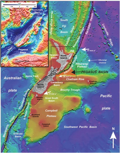
Pegasus Basin is one of a series of depocentres, including the Northeast Slope, Raukumara, East Coast and Chatham Slope basins (Uruski Citation2010, Citation2012; NZP&M Citation2013), which were initiated along the Mesozoic Gondwana margin subduction front (). The presence of a large sedimentary basin off southeast North Island and northeast South Island was initially indicated by a regional gravity low (). A thick sedimentary succession (over 5 seconds two-way-time (s TWT)) was first imaged by the ‘Explora’ multi-channel seismic line, acquired in 1994 (Field et al. Citation1997). Subsequently, during 2009–2010 3000 km of high-quality 2D seismic data were acquired by the New Zealand Government during its ‘PEG09’ reconnaissance survey (), which aimed to encourage exploration for petroleum resources in the basin. Assessments of the basin's petroleum prospectivity are available for download via the New Zealand Petroleum & Minerals website (http://www.nzpam.govt.nz/cms/tools-and-services/geoscience-exploration-data; Uruski & Bland Citation2011; Bland et al. Citation2012, Citation2014a, b). The PEG09 seismic data confirmed the occurrence of a thick and extensive sedimentary succession (Uruski & Bland Citation2011) in an apparently triangular-shaped offshore area, covering at least 25,000 km2 east of Cook Strait. The basin's full extent is unknown however, as it extends beyond the limits of the seismic coverage used. Satellite-derived gravity data () suggest that it might cover an area of up to 50,000 km2 (Uruski Citation2010).
Figure 2 Reconstructions of the New Zealand region from the Early Cretaceous to early Neogene (adapted from Stagpoole et al. Citation2008). Simplified paleo-positions of Pegasus Basin and adjacent sedimentary basins are shown. The grey dashed polygon represents the approximate shape and position of the Hikurangi Plateau (excluding parts subducted beneath the Chatham Rise; after Reyners Citation2013). A, Subduction along the Gondwana margin. B, Separation of Zealandia from Gondwana, Tasman Sea formation and thermal subsidence and sedimentation along eastern sedimentary basins. C, Continued thermal subsidence and sedimentation across Pegasus Basin, rifting in southern Zealandia and compression in the northwest. D, Propagation of the Hikurangi subduction system beneath eastern New Zealand. Onset of deformation in the East Coast Basin, and relative tectonic quiescence in Pegasus Basin.
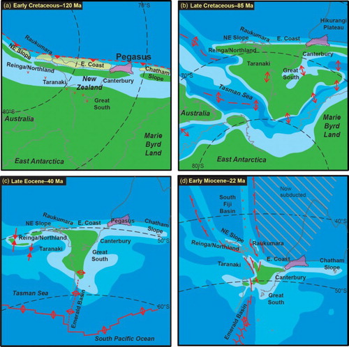
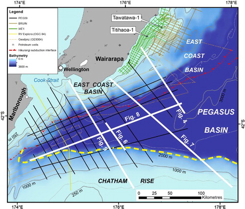
Figure 3 Bathymetry of the Pegasus Basin region and locations of seismic surveys and petroleum exploration drillholes. The locations of other figures in this article are also indicated.
The Pegasus Basin lies immediately north of the Chatham Rise, a 1000 km long bathymetric ridge that extends almost due east from South Island. The rise is underlain by continental crust that forms part of the Mesozoic Gondwana accretionary wedge (Davy et al. Citation2008). Average water depth along the crest of the Chatham Rise is about 500 m; the Chatham Islands lie near its eastern end (). In the northwest, offshore from Wairarapa, the present-day water depths over the Pegasus Basin are in the range 1000–1500 m, deepening to >3000 m in the northeast (). Much of the basin lies at depths greater than 2000 m. Several canyons either feed sediments into the basin or have done so in the past; they are tributaries to the Hikurangi Channel system that extends along the Hikurangi Trough, crosses the Hikurangi Plateau and, eventually, deposits sediments in the Kermadec Trench (Lewis Citation1994). From the southwest these tributary canyons are the Kaikoura, Cook Strait, and Pahaoa canyons. The Cook Strait Canyon has several branches that episodically transport sediment from both North and South islands, mainly during times of sea-level lowstand. More detailed descriptions of the present-day bathymetry and seafloor morphology of Pegasus Basin are given in Lewis et al. (Citation1998), Lewis & Pantin (Citation2002) and Bland et al. (Citation2014b).
Pegasus Basin, dominantly a Neogene depocentre, is separated from the East Coast Basin by the active subduction thrust (; see also online supplementary material for a high-resolution version of this figure and other seismic lines, figs S1–S5) that propagated into this part of eastern Zealandia during the earliest Miocene (King Citation2000). Prior to the inception of Neogene subduction, the basins were largely parts of a single geological entity (e.g. ) and it is reasonable to assume that their pre-Neogene geological histories are similar. The simple stratigraphy and structure show that for Pegasus Basin there has been little or no overprint from Neogene–Recent tectonics (Uruski & Bland Citation2011); the position of the East Coast Basin inboard of the Hikurangi subduction interface means it has been variably—typically at least moderately—deformed (; Davey et al. Citation1986; Ballance Citation1993; Lewis & Pettinga Citation1993; Field et al. Citation1997; Barnes et al. Citation2002; Barnes & Nicol Citation2004; Lee et al. Citation2011; Bland et al. Citation2012a). The little-deformed stratigraphic architecture preserved in Pegasus Basin therefore provides new constraints regarding the stratigraphic framework of the adjacent East Coast Basin, and helps us better understand the petroleum potential of these basins. This paper presents an interpretation of the Pegasus Basin geology and discusses some tectonic implications for the geological evolution of eastern Zealandia.
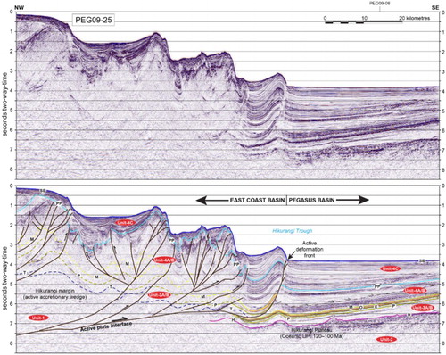
Figure 4 Seismic line PEG09-25, showing the transition from little-deformed strata in Pegasus Basin to folded and faulted rocks within the East Coast Basin. The most seaward fold is taken to represent the location of the present-day subduction interface east of North Island and the western boundary of Pegasus Basin. E, base Eocene; H, top Hikurangi Plateau; M, base Miocene; O, base Oligocene; P, base Paleocene; PP, base Pliocene–Pleistocene; SB, seabed; T, top Torlesse basement.
Geological setting
The near-linear northern margin of the Chatham Rise represents a former plate boundary along the eastern margin of Gondwana, a zone of plate convergence active until earliest Late Cretaceous time (; Bradshaw Citation1989; Wood & Davy Citation1994; Davy et al. Citation2008; Reyners Citation2013). This fossilised subduction zone now shows a continuum from an inboard (southern) domain of highly deformed rocks, through a domain of moderately folded and faulted strata along the paleo-deformation front (northern region), to a structurally simple domain of almost undeformed strata which overlie the Hikurangi Plateau outboard of the Mesozoic subduction front. Collision of the Early Cretaceous Hikurangi Plateau, a large igneous province (LIP), with the Chatham Rise is thought to have choked subduction along this part of the margin (e.g. Wood & Davy Citation1994; Davy et al. Citation2008).
The present plate boundary through Zealandia runs in a NNE–SSW direction from the Kermadec Trench in the north, along the Hikurangi Trough east of North Island and into the Marlborough region of northeast South Island, before passing along the Alpine Fault of central South Island (). The Marlborough region, characterised by a set of oblique-slip faults with large displacements that splay from the major compressional strike-slip Alpine Fault, marks the transition from west-directed ocean–continent subduction to oblique continent–continent collision. Further south, convergence of continental crust of eastern South Island, the Chatham Rise and Campbell Plateau with continental crust of western South Island has resulted in compressional strike-slip faulting and large-scale uplift of the boundary to form the Southern Alps.
Pegasus Basin represents that part of the southern Hikurangi Trough lying entirely on the subducting Pacific plate, immediately east of the modern Hikurangi subduction interface and near the transitional zone between subduction of the Pacific plate beneath eastern North Island and strike-slip faulting through South Island (, 3; Barnes et al. Citation1998). The northwest margin of Pegasus Basin has, for convenience, been defined by the seaward limit of the modern subduction interface (e.g. Uruski Citation2010, Citation2012; NZP&M Citation2013); this boundary is by its nature transitory, changing its geographic position as and when the subduction interface relocates (). The basin's southern boundary is placed at the northern margin of the Chatham Rise, which corresponds to the edge of the modern bathymetric depression in this region as well as a dramatic thinning of post-basement sedimentary cover. Total sediment thickness in the basin appears to reduce to the east and northeast, away from the sediment sources of North Island, northeast South Island and the Chatham Rise. We therefore place the eastern basin limit at the position where sediment thickness is <1000 m, an arbitrary cut-off point often employed in petroleum systems modelling in New Zealand above which seal (overburden) capacity is generally considered to be insufficient to maintain a significant petroleum column (e.g. Field et al. Citation2014).
The Pegasus Basin and immediately adjacent areas to the west and south comprise the only area we are aware of where two opposing subduction systems, ancient and modern, are clearly visible on any single seismic line.
Data
Seismic
Industry data
Data from the 1971 Mobil and 1972 Gulf surveys (; Uruski & Jones Citation2008) are of poor quality and little useful information can be obtained from the lines across Pegasus Basin. The first high-quality seismic survey acquired east of North Island and relevant for Pegasus Basin was IAE1, acquired offshore from Wairarapa and mainly within the East Coast Basin by Amoco in 1990. This c. 1000 km survey is a closely spaced grid, mainly confined to the shelf area (). The Titihaoa-1 well was drilled on the basis of these data in 1994. A very closely spaced survey was acquired nearby by Westech Energy in 2000. Subsequently, TAP Oil assumed operatorship of the permit and drilled Tawatawa-1 in 2004. Later, the TAP-acquired ‘Bruin’ seismic survey (2007) extended the IAE1 survey to deeper waters and across the accretionary wedge of the East Coast Basin.
The PEG09 survey, which forms the basis of this study, was acquired by the New Zealand Government to stimulate exploration interest in the area's petroleum resource potential (; Uruski & Bland Citation2011; Bland et al. Citation2012a, Citationb, Citation2014b). Approximately 3200 km of high-quality 2D seismic data were acquired by RV Reflect Resolution between November 2009 and March 2010 (RPS Energy Citation2010). The survey includes the SAHKE-01 research line, designed to target and image the crustal structure of the lower part of North Island (Henrys et al. Citation2013), and recorded on an array of ocean-bottom seismometers and land-based seismometers. Only the seismic reflection data were available for this study. Acquisition parameters of the PEG09 survey are described in RPS Energy (Citation2010).
Research data
The 1993 Geodynz survey (; Collot et al. Citation1996) acquired seismic reflection and swath bathymetry data. The survey is generally oriented parallel to the modern subduction margin, and provides regional coverage. However, fold is low and few reflections are discernible below the seabed multiple, which usually occurs at 1–3 s TWT. These data provide some infill detail for shallower units as well as information on compressional structures (Barnes & de Lepinay Citation1997; Barnes et al. Citation1998).
A multi-channel seismic line, acquired in 1994 by the Italian research ship RV Explora to image crustal structure (Field et al. Citation1997), was the first line across Pegasus Basin to show a thick sedimentary succession of probable Neogene age; strata above this were interpreted to be of Paleogene and Cretaceous age. A second multi-channel seismic line (line CM05-38) was acquired in 2005 by the New Zealand Government and GNS Science through the Tawatawa-1 site and across the accretionary wedge of the East Coast Basin to the Hikurangi Trough.
Depth conversion
Time grids for the major seismic horizons mapped in this study were generated within the Schlumberger CPS3 mapping package, exported with RMS stacking velocities and loaded into a Petrosys project. Velocity picks were filtered and re-interpolated for a minimum TWT interval between picks of 200 milliseconds (ms) and a maximum of 1000 ms to reduce uncertainty in Dix equation calculations.
Initial interval velocities were calculated using the Dix equation. The maximum interval velocity was clipped to 6000 m s–1 before interpolation and smoothing. A 3D velocity grid was constructed from the interval velocities. Grid size was 2 × 2 km horizontally and 200 ms vertically. Interval velocities were interpolated and smoothed over three iterations. Average velocities were derived from two-way time and smoothed interval velocities. Horizon grids were then depth-converted using:
Wells
No wells have been drilled in Pegasus Basin; Titihaoa-1 and Tawatawa-1, drilled 150–200 km north in the East Coast Basin, are the nearest (). Both had strong sub-commercial dry gas shows. Titihaoa-1 reached total depth (2740 m) in Middle Miocene rocks, above the targeted Early Miocene turbidites. Tawatawa-1 reached 1560 m and penetrated no lower than the basal part of the Late Miocene succession, above its prognosed Middle Miocene target horizon. Three Ocean Drilling Project (ODP) wells were drilled on the Hikurangi Plateau and the adjacent sediment apron north of the Chatham Islands. Although located many hundreds of kilometres east of the basin, they have provided some stratigraphic ties into the deeper (Cretaceous and Paleogene) parts of the basin fill.
Stratigraphic correlation using the available well and seismic data has proved to be difficult within the East Coast Basin; the age of the succession encountered in Tawatawa-1 was not accurately predicted even though the earlier well Titihaoa-1 had been drilled only 25 km to the southwest. Given that context the Pegasus Basin seismic data has been tied, as best we can, to the Tawatawa-1 and Titihaoa-1 wells (Uruski & Bland Citation2011; Bland et al. Citation2012a, Citation2014a, b). These ties were made across distances of 70–80 km oblique to the deformation front, through complexly folded and faulted Neogene successions, and across the Hikurangi subduction margin. The uncertainties are large; the ties adopted are supported by other geological evidence such as broad seismic character and apparent timing of deformation phases.
Seafloor samples
A number of bottom samples were previously acquired in the vicinity of the Pegasus Basin. Seafloor samples were recovered from Pegasus Basin using bottom trawls, rock dredges and piston cores, including mudstone, siliceous mudstone, limestone, altered gabbro and diorite. Some hand specimens contain volcaniclastic material and/or pyrite. An assessment of the seafloor samples has been given elsewhere (Plaza-Faverola et al. Citation2012). The seafloor samples were of limited use for calibrating the seismic surveys and determining the lithologies present at depth for this study because of the uncertainties and ambiguities associated with seafloor sampling. The samples are documented in the Fossil Record (FRED) and PETLAB databases held at GNS Science (see also Lewis Citation1985).
Two samples were collected from near PEG09 seismic lines. Sample G955A has been dated as Pliocene in age. Sample 8802-6 is possibly of Eocene age, although our interpretation of the PEG09 seismic data indicates the rocks at the sample site should be younger; the reported Eocene age may well be from redeposited material.
Stratigraphic analogues from surrounding basins
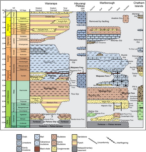
As there are no drillholes in Pegasus Basin, and because only a small part (Middle Miocene–Recent) of the laterally equivalent basin-fill in the offshore East Coast Basin has been penetrated by drillholes, our understanding of the stratigraphic character of Pegasus Basin relies heavily on correlation of offshore units with onshore equivalents (). The seismic stratigraphy presented in this paper is correlated with, and calibrated from, the regional Jurassic–Recent stratigraphy of southern Wairarapa, Marlborough, northern Canterbury and the Chatham Islands, as established by the QMAP series of onshore 1:250 000 geological maps (Begg & Johnston Citation2000; Lee & Begg Citation2002; Rattenbury et al. Citation2006; Forsyth et al. Citation2008; Mortimer et al. Citation2014; ).
Figure 5 Simplified chronostratigraphic panels for the Wairarapa, Marlborough, Chatham Islands and Hikurangi Plateau areas. These regions surround Pegasus Basin and provide some stratigraphic analogues for the stratigraphy likely to occur in the basin. After Uruski & Bland (Citation2011).
Basement
The Torlesse Composite Terrane comprises the most extensive part of the Eastern Province of New Zealand's basement rocks. It is interpreted to have been deposited mainly as a series of fan-delta to mass-flow successions within a subduction trench, and accreted along the Gondwana subduction margin (Bradshaw Citation1989; Barnes Citation1990; Mortimer Citation1994, Citation2004; Mortimer et al. Citation2002, Citation2014; Bassett & Orlowski Citation2004). It constitutes geological basement in Wairarapa (Barnes Citation1990; Lee & Begg Citation2002), Marlborough (Rattenbury et al. Citation2006), north Canterbury and the Chatham Rise (Forsyth et al. Citation2008). In Wairarapa and Marlborough, east of the Esk Head Belt, Torlesse Composite Terrane rocks cropping out are of Late Jurassic–Early Cretaceous age (e.g. Adams & Graham Citation1996; Begg & Johnston Citation2000; Lee & Begg Citation2002; Bassett & Orlowski Citation2004; Rattenbury et al. Citation2006). Torlesse Composite Terrane rocks of Permian and Triassic ages were dredged from the Chatham Rise (Wood et al. Citation1989; Forsyth et al. Citation2008).
Late Early Cretaceous–Paleogene
The oldest post-Torlesse Composite Terrane rocks from southeast Wairarapa and Marlborough are of Motuan age (Late Albian, c. 100 Ma) and the earliest post-Torlesse rocks of the Chatham Rise area are inferred to be the same. The facies are mudstone-dominated in western Wairarapa (Lee & Begg Citation2002), whereas in eastern regions they include a mix of coarse- and fine-grained lithofacies deposited in submarine fans across a range of water depths from shelf to lower slope (Crampton Citation1997). In Marlborough, the equivalent rocks include mass-flow conglomerates and sandstones and mudstones with many slump features, interpreted to have been deposited in deep-marine conditions (Crampton & Laird Citation1997), perhaps in slope basins. In Marlborough the overlying strata include conglomerates with igneous clasts (Reay Citation1993), siltstone and glauconitic sandstone (Rattenbury et al. Citation2006), inferred to be coarse clastics deposited in active extensional basins, and a deep-water turbidite unit (Suggate et al. Citation1978; Hollis et al. Citation2005b). At the Chatham Islands, rocks of this age are represented by a terrestrial succession including carbonaceous quartzofeldspathic sandstones and claystones, with minor discontinuous lignite beds (Campbell et al. Citation1993).
Late Cretaceous successions from the Chatham Rise, Marlborough and Wairarapa generally reflect deepening of paleo-environments with time, culminating in widespread deposition of the fine-grained Whangai Formation, which is potentially a regionally significant petroleum source rock (Moore Citation1988; Field & Uruski et al. Citation1997; Hollis & Manzano-Kareah Citation2005). Several Late Cretaceous changes in relative sea level are recognised, particularly from work in Marlborough. An early Maastrichtian sea-level fall has been recognised in parts of Marlborough and the resulting erosional unconformity was succeeded by a transgressive sandstone and an overall deepening that continued until at least Middle Eocene time (Crampton et al. Citation2003; Browne et al. Citation2005). Late Cretaceous Whangai Formation rocks are truncated by an erosional unconformity in parts of southeast coastal Wairarapa, succeeded by calcareous units of latest Cretaceous and Paleocene ages (Moore Citation1988; Hines et al. Citation2013).
The Cretaceous–Tertiary boundary is well exposed in Marlborough (Hollis Citation2003); there is no marked change in lithofacies since deposition of the Whangai Formation and equivalent rocks (e.g. Mead Hill Formation) continued through much of the Paleocene. Near the end of the Paleocene, a relative sea-level fall (Hollis et al. Citation2005a, Citation2014; Schiøler et al. Citation2010) was associated with deposition of the Waipawa Formation, a regionally extensive 10–50 m thick marine mudstone with significant petroleum generation potential. Glauconitic sandstones associated with the Waipawa Formation appear, at least in part, to be shallow-water correlatives. On the Chatham Rise, Paleocene deposition was characterised by deposition of sandstones, greensands and limestone (Wood et al. Citation1989).
In the southern Wairarapa and Marlborough regions the younger Paleogene rocks are more calcareous and, by the Oligocene, carbonate deposition dominated in some areas (e.g. Field & Uruski et al. Citation1997). A major unconformity, the so-called ‘Marshall Paraconformity’, is thought to have been caused by global cooling, sea-level fall and intensification of cold southern-sourced deep-water currents (Fulthorpe et al. Citation1996). In Marlborough this unconformity removed c. 14 million years of the geological record (from Middle Eocene to Middle Oligocene), and in parts of the East Coast Basin a minor facies change within Oligocene deep-water calcareous mudstone is inferred to represent a time gap of 5 million years (Morgans & Hollis Citation1999). The Marshall Paraconformity has not been recognised in the Chatham Rise area where the Paleogene succession is thin and there are few samples, although an unconformity of inferred Late Oligocene age may represent a period of 8 million years of non-deposition (Wood et al. Citation1989).
Neogene
The initiation and development of the modern plate boundary through New Zealand resulted in accelerated deformation and provided a new pulse of clastic sediments to sedimentary basins, where thick successions accumulated. However, the Chatham Rise remained largely submerged and Neogene strata are typically thin across the Chatham Rise and the North Chatham Slope (Wood et al. Citation1989; Barnes Citation1992, Citation1994).
In onshore Wairarapa Neogene sedimentation was dominated by mudstone, punctuated in places by thick sandstone units (Field & Uruski et al. Citation1997) that mark local relative sea-level falls of probable tectonic origin. Channel and basin-floor sandstones are common. Turbidite flows appear to have been channelled along slope basins by rising anticlines roughly parallel to the coast; gaps in the morphology allowed them to divert east to flow into deeper water.
In Marlborough, the Neogene sedimentary rocks were commonly deposited in active fault-angle depressions that sometimes reached bathyal depths. Active deformation processes are reflected in the facies present; these include the Great Marlborough Conglomerate, a distinctive unit containing (among other lithotypes) clasts of Torlesse basement rocks deposited in broad shallow feeder channels and within canyons incised into the Miocene continental shelf (Lewis et al. Citation1980; Townsend Citation2001; Rattenbury et al. Citation2006). The Miocene canyons are likely to have contributed sediments into the Pegasus Basin.
Volcanic rocks on the Chatham Rise were locally important sources of clastic material during the Late Miocene and Pliocene, and are generally intimately associated with limestones at the Chatham Islands (James et al. Citation2011).
Pegasus Basin stratigraphy
Our interpretation of the stratigraphic architecture of Pegasus Basin is based primarily on seismic facies, constrained by the geology of surrounding areas. Four tectonostratigraphic units are differentiated, each of which relates to a defined tectonic and/or depositional phase in the basin history. High-resolution versions of the seismic lines (un-interpreted and interpreted) depicted in and – are available as supplementary files.
Figure 6 Part of seismic line PEG09-021 showing the typical seismic character of Units 1 and 3A of the Torlesse Composite Terrane, which represent basement strata in Pegasus Basin. Strata labelled ‘Unit-1’ are structurally complex metasedimentary basement rocks of the Torlesse Composite Terrane, and possibly of Jurassic–Early Cretaceous age; ‘Unit-2’ is the Hikurangi Plateau; ‘Unit-3A’ is interpreted as faulted and folded Early Cretaceous sediments frozen in the process of subduction accretion. They have characteristics of ‘Unit-1’ and ‘Unit-3B’, the latter comprising relatively undeformed Early Cretaceous sedimentary rocks that never reached the Gondwana subduction margin. ‘Unit-4A’ comprises sedimentary rocks of Early Miocene age, ‘Unit-4B’ comprises sedimentary rocks of inferred Middle–Late Miocene age, and ‘Unit-4C’ comprises sedimentary rocks of Pliocene–Pleistocene age. Abbreviations as for Fig. 4.
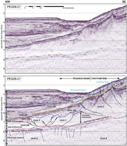
Figure 7 Northwest–southeast seismic cross-section of Pegasus Basin from the Cook Strait area to the crest of the Chatham Rise (line SAHKE-01), illustrating the major tectonostratigraphic elements. This profile images two ‘opposing’ subduction systems: the modern Hikurangi margin (left) and the ancient Gondwana margin (right), with the latter ‘frozen’ in the process of subduction accretion. The modern subduction interface is clearly visible; the most-seaward fold of the East Coast Basin is taken to represent the subduction interface and the boundary with the adjacent Pegasus Basin. Also evident is the little-deformed character of Pegasus Basin, compared with the more deformed East Coast Basin. The asymmetrical Neogene succession in Pegasus Basin is prominent in this cross-section. Abbreviations as for Fig. 4.
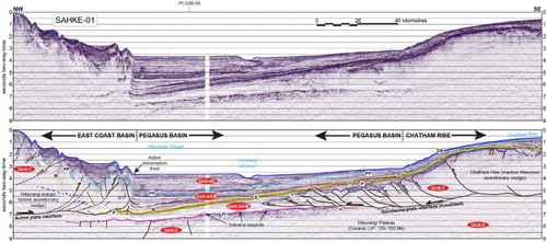
Figure 8 WSW–ENE seismic dip-profile broadly along the axis of Pegasus Basin from the Chatham Rise (line PEG09-08). The ancient Gondwana margin is prominent. The Hikurangi Channel, a prominent present-day seafloor feature, is evident on this line. Abbreviations as for Fig. 4.
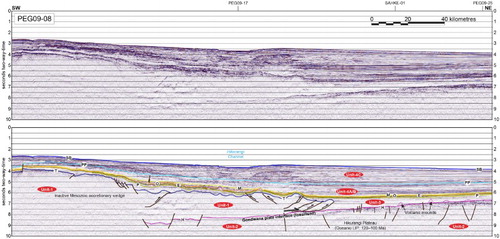
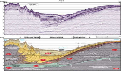
Figure 9 Northwest–southeast seismic cross-section of Pegasus Basin from the Cook Strait area to the crest of the Chatham Rise (line PEG09-17), illustrating the major tectonostratigraphic elements of this part of eastern New Zealand. This profile images two ‘opposing’ subduction systems, the modern Hikurangi margin (left) and the ancient Gondwana margin (right) with the latter ‘frozen’ in the process of subduction accretion. The modern subduction interface is clearly visible, and defines the most-seaward fold of the East Coast Basin which separates this basin from the adjacent Pegasus Basin. Also evident is the little-deformed character of Pegasus Basin, compared with the more-deformed East Coast Basin. The asymmetrical Neogene succession in Pegasus Basin is prominent in this cross-section and reflects the downwarping of underlying basement associated with the Neogene Hikurangi subduction system. Note also the widespread bottom-simulating-reflector in upper parts of the profile, which is interpreted to represent the gas hydrate stability zone. Adapted from Bland et al. (Citation2014a, b).
Units 1 and 2: Basement rocks
Basement rocks beneath Pegasus Basin are inferred to comprise: (1) Jurassic–late Early Cretaceous metasedimentary rocks of the Torlesse Composite Terrane; and (2) Early Cretaceous rocks of the mainly igneous Hikurangi Plateau and overlying volcaniclastics and limestones (Davy et al. Citation2008).
Unit 1: Torlesse Composite Terrane metasedimentary basement
The PEG09 seismic dataset gives a unique insight into the stratigraphy and structure of the fossil Gondwana subduction margin, in that seismic sections extending northwest from the Chatham Rise and across Pegasus Basin clearly show structurally complex and imbricated Torlesse basement passing laterally into a unit of broadly folded and faulted strata, with structurally simpler, almost undeformed equivalents further from the margin (–). These data have captured a snapshot of the cessation of subduction, frozen in time. Pegasus Basin and the Chatham Rise cover are perhaps one the best-imaged and least-deformed fossil subduction systems known.
As the Hikurangi Plateau (see below, ‘Unit 2’) impinged on the Chatham Rise in the late Early Cretaceous (Davy et al. Citation2008), sediments atop the plateau—presumably distal clastic and calcareous sediments such as those drilled above basement in the ODP Leg 181 holes (Carter et al. Citation1999)—were scraped off and accreted to the outer parts of the subduction margin. These accreted sediments contributed to the last phases of growth of the accretionary wedge and are now preserved as the most northerly (basinwards) parts of Unit 1. Since the imbricated unit is accreted and ‘sutured’ to the plate of the former Gondwana margin it satisfies the conditions for inclusion in the Torlesse Composite Terrane, consistent with interpretations of equivalent Pahaoa Group rocks cropping out in southeast Wairarapa (Barnes & Korsch Citation1990, Citation1991; Begg & Johnston Citation2000; Lee & Begg Citation2002; Mortimer et al. Citation2014).
Because moderately deformed and structurally simple units beyond the Gondwana subduction interface were sedimentary cover on the incoming plate, at and outboard of the subduction zone at the time it became inactive, they have not been accreted to the Gondwana margin and should not be considered a part of the Torlesse Composite Terrane. We therefore draw the margin of Unit 1—the Torlesse Composite Terrane—at the major south-dipping thrust fault that separates imbricated rocks from their moderately to weakly deformed, unaccreted lateral equivalents (e.g. –). Rocks outboard of the imbricated unit are structurally and probably metamorphically different from their accreted equivalents; they are inferred to be equivalents of the onshore Middle Cretaceous basin-fill ‘cover’ rocks, with which they are included (e.g. Mazengarb & Speden Citation2000; Rattenbury et al. Citation2006; Bland et al. Citation2012a; ).
The geology revealed by the PEG09 seismic surveys is analogous to that seen in the onshore East Coast Basin where in places the oldest little-deformed cover rocks are the same age as, or even slightly older than, the youngest deformed Torlesse (e.g. Barnes & Korsch Citation1990, Citation1991; Mazengarb & Speden Citation2000; Rattenbury et al. Citation2006). Onshore geology in the Marlborough and southern Wairarapa regions shows that cessation of convergent margin compressional deformation and imbrication was diachronous, occurred during the period 116–100 Ma, and that the earliest, structurally simple cover beds were deposited close to the uplifted and eroding basin margin before imbrication had ceased at the contemporary deformation front.
The PEG09 seismic reflection data show that the complexly deformed and imbricated package of Unit 1 extends north beneath the North Chatham Slope (–) and is contiguous with known submarine outcrops of Torlesse rocks on the Chatham Rise. The unit is truncated by a north- to northwest-dipping unconformity, which is overlain and onlapped by structurally simple basin-fill sediments. The unconformity truncates underlying reflectors that have a general dip to the southeast. The seismic amplitude of the unconformity decreases with depth below the seafloor; this could represent a change with depth in the physical properties of rocks across the interface or, alternatively, it may be a consequence of the gain function applied in processing the seismic data. Locally, below the unconformity surface, reflectors are folded, truncated and intermittently continuous; at least some are interpreted to represent bedding. A number of bright reflectors that are more continuous truncate or dislocate shorter, folded reflectors and are interpreted to be thrust faults. Also, footwall and hanging-wall cut-offs are easily interpretable in places. Elsewhere there is little evidence of coherent reflectors, implying steep dips or homogenous rocks with no contrasts in acoustic impedance; for Torlesse rocks we consider the former is more likely. Reflectivity generally decreases with depth, suggesting rapid absorption of seismic energy.
The base of Unit 1 is not well resolved by the seismic surveys; in places rocks with no coherent reflectors or weak reflectors apparently overlie a unit with bright, laterally persistent reflectors (– ) which, from comparison with seismic signatures at depth elsewhere (e.g. Wood & Davy Citation1994; Davy et al. Citation2008), we infer to be intercalated volcanic rocks, volcaniclastics, limestone and chert at the top of the Hikurangi Plateau (see below). Elsewhere, seismic data suggest that subducted Early Cretaceous sedimentary rocks occur between the Hikurangi Plateau and the Torlesse Composite Terrane ().
By analogy with their counterparts onshore, the Torlesse rocks beneath Pegasus Basin are inferred to have been deposited mainly in marine environments within an accretionary wedge (e.g. Barnes Citation1990; Mortimer Citation1994). Some Pahau Terrane rocks cropping out in Canterbury are interpreted to have been deposited in a shallow-water fan-delta setting (Bassett & Orlowski Citation2004), and similar rocks could potentially occur beneath Pegasus Basin. Where exposed in the Chatham Islands, Marlborough and southern Wairarapa, the rocks are weakly to moderately metamorphosed; metamorphic grade decreases northwards in the Chatham Islands and eastwards in Wairarapa (Wood et al. Citation1989; Field et al. Citation1997).
Unit 2: Hikurangi Plateau
Unit 2 is the Hikurangi Plateau, a major oceanographic feature of eastern Zealandia (; Davy & Wood Citation1994; Wood & Davy Citation1994; Davy et al. Citation2008). The plateau is regarded as a third component of the large igneous province (LIP) that originally included the Ontong–Java and Manihiki plateaux (Mortimer & Parkinson Citation1996; Taylor Citation2006). The original LIP is thought to have originated in the Late Jurassic–Early Cretaceous as part of an oceanic spreading centre that lay close to a hotspot plume head, similar to present-day Iceland (Hoernle et al. Citation2010). Ar/Ar dating of feldspars from the Hikurangi Plateau lavas shows that volcanism began at or before 118 Ma. The plateau is surmounted by many large volcanic seamounts erupted during a second and distinct phase of volcanism beginning about 20 million years after the plateau-forming event (Taylor Citation2006; Hoernle et al. Citation2010). A triple junction formed during the late Early Cretaceous and the three components of the LIP moved in different directions, carried by their respective plates (Davy et al. Citation2008; Hoernle et al. Citation2010). The northeast margin of the Hikurangi Plateau now lies 1200–1600 km south-southwest of the Osbourn Trough (present-day latitude 026°S), which is thought to have been the spreading centre that separated the Hikurangi Plateau from the Manihiki Plateau (Billen & Stock Citation2000; Taylor Citation2006).
The Hikurangi Plateau was partially subducted beneath the Chatham Rise, probably during the late Early Cretaceous (e.g. Davy & Wood Citation1994; Wood & Davy Citation1994; Davy et al. Citation2008; Reyners et al. Citation2011), and beneath the eastern North Island from around the Late Miocene (c. 10 Ma; Reyners et al. Citation2011; Reyners Citation2013). No equivalents of the Hikurangi Plateau are known onshore (N Mortimer, GNS Science, pers. comm. 2012).
Seismic reflection lines and crustal models based on gravity anomaly data indicate that the crust of the Hikurangi Plateau is between 12 and 15 km thick (Davy Citation1992; Davy & Wood Citation1994; Davy & Uruski Citation2002; Davy et al. Citation2008), although it is recognised that such models are blind to lower crust bodies with densities similar to mantle density. Modern earthquake epicentre datasets indicate that the plateau may be 30–40 km thick, with the geochemical phase of its basal layers comprising eclogite (Reyners et al. Citation2011).
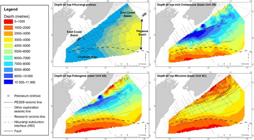
PEG09 seismic lines image the upper layers of the Hikurangi Plateau better than any previous data. The top parts of the plateau are marked by a package up to 2 s TWT thick, of moderate to high-amplitude, continuous to moderately continuous dipping reflections () that are in places interrupted or broken by extensional faulting and by isolated buried volcanic mounds in which reflectors downlap onto the surrounding layered reflective sequence (e.g. ). We place the top of the Hikurangi Plateau at the top of this package ( –), which lies at depths of about 8000 m below sea level in the southwest of the basin, shallowing to about 3000 m below sea level in the northeast ().
Figure 10 Depth maps (metres below sea level) to the top-Hikurangi Plateau and the base of Units 3B, 4A and 4C within Pegasus Basin. The extent of these maps is constrained by the PEG09 seismic survey; Pegasus Basin probably continues east of the area depicted here. Adapted from Bland et al. (Citation2012, Citation2014b).
The continuous seismic reflectors within the upper package of the Hikurangi Plateau have previously been interpreted as a succession of extrusive volcanic deposits and volcaniclastic and pelagic sediments (Bradshaw Citation1989; Wood & Davy Citation1994; Wood et al. Citation1994; Davy & Uruski Citation2002; Hoernle et al. Citation2010). Drilling of the analogous Ontong–Java Plateau has shown that upper layers of that plateau include lithic tuff, lapillistone, bioturbated limestone, chert, claystone and thin organic-rich claystone, in places intercalated with pillow lavas (Sikora & Bergen Citation2004). The upper package of the Hikurangi Plateau is therefore interpreted to represent intercalated volcanic rocks, volcaniclastics and sediments, as recorded from the upper parts of the equivalent Ontong–Java Plateau. The upper layers of the plateau may also include authigenic carbonates and deep-sea oozes, deposited as it was rafted to its present location.
Rock samples from Hikurangi seamounts include lava, breccia, conglomerate and sandstone, interpreted to result from shallow-marine to subaerial eruptions, with erosion at or above sea level (Mortimer & Parkinson Citation1996; Hoernle et al. Citation2010). The presence of guyots on the southern part of the Hikurangi Plateau indicates that it once lay at water depths 2 km shallower than at present (Bryan Davy, GNS Science, pers. comm. 2014).
The top of the Hikurangi Plateau passes beneath the imbricated Torlesse Composite Terrane basement (Unit 1) that forms much of the Chatham Rise. The plateau is in turn overlain by a package of undeformed to gently deformed sedimentary rocks inferred by superposition to be of Early Cretaceous age, the younger elements of which onlap the Chatham Rise.
Unit 3: late Early Cretaceous and Paleogene sedimentary rocks (c. 105–25 Ma)
A transition from convergent margin tectonics to long-lived thermal subsidence of the underlying Hikurangi Plateau is inferred to have commenced during c. 110–100 Ma as subduction progressively ceased along this part of the Gondwana subduction margin (Davy et al. Citation2008; Davy Citation2014). We have subdivided the package of rocks deposited during this late Early Cretaceous–Oligocene time of subduction termination and thermal subsidence into two sub-units: Units 3A and 3B.
Unit 3A
The boundary between more-deformed ‘basement’ rocks (Unit 1) and the oldest ‘cover’ rocks (Unit 3A) is marked by the most outboard thrust of the fossilised Chatham Rise subduction margin ( –). Based on their stratigraphic position atop the Hikurangi Plateau and outboard of the Gondwana subduction margin, rocks of Unit 3A are of late Early–early Late Cretaceous age. Unit 3A can be correlated using seismic mapping to unit ‘MES’ of Davy et al. (Citation2008) (Barnes et al. Citation2010; Uruski & Bland Citation2011; Plaza-Faverola et al. Citation2012); the two units are therefore probable age-equivalents.
Many rocks of late Early–early Late Cretaceous (Albian and Cenomanian) age cropping out in the Raukumara (lower Matawai Group; Mazengarb & Speden Citation2000), Wairarapa (lower Mangapurupuru Group; Crampton Citation1997; Begg & Johnston Citation2000; Lee & Begg Citation2002) and Marlborough areas (lower Coverham Group; Rattenbury et al. Citation2006) share lithological and structural characteristics of both basement and ‘cover’. The fossilised subduction margin revealed by the PEG09 seismic data suggests that these rocks are likely to be equivalents of strata that were immediately adjacent to the Gondwana subduction margin, and were perhaps beginning the process of subduction accretion when subduction ceased. Because they were not fully accreted to the subduction margin, they are not included within the basement succession.
Further outboard of the fossilised Gondwana subduction margin is a succession of age-equivalent broadly folded to undeformed strata that overlie and commonly downlap onto the top of unsubducted Hikurangi Plateau. These rocks are interpreted to be marine basin-floor sediments of late Early and early Late Cretaceous age (–) that never reached the subduction margin.
The top of Unit 3A is deepest adjacent to the modern Hikurangi subduction interface (c. 10 km below sea level), shallowing to the south where it onlaps the Chatham Rise ().
Unit 3B
Seismic data across the north flank of the Chatham Rise show a bright, southeast- to northwest-dipping unconformity at about 2–7 s TWT. The seismic character of the unit below the unconformity is consistent with indurated and deformed Torlesse basement rocks of Unit 1 (see discussion above regarding Unit 1; ). The origin of this surface is attributed to the Hikurangi Plateau impacting the Gondwana subduction margin between c. 100 and 105 Ma (Davy et al. Citation2008). Regional-scale uplift and erosion resulted, which formed the top-Torlesse (Unit 1) unconformity so clearly evident on seismic data ( –; e.g. Wood et al. Citation1989; Uruski & Bland Citation2011). The provenance of at least some Cretaceous sediment deposited in Pegasus Basin after 105 Ma is therefore likely to be uplifted and eroded Torlesse Composite Terrane. Overlying the unconformity is a well-bedded sedimentary succession. On the basis of stratigraphic position we consider this package to be of Late Cretaceous and Paleogene age, and assign it to Unit 3B.
Previous seismic interpretation offshore of eastern North Island has identified a relatively thin (several hundred milliseconds TWT) package of coherent, roughly laminar, subparallel, high-amplitude reflections across the Hikurangi Plateau. Termed ‘Sequence Y’, this was interpreted by Wood & Davy (Citation1994) as a condensed section spanning the Late Cretaceous and most of Paleogene time, an interpretation confirmed by subsequent ODP scientific drilling at site 1124 (Carter et al. Citation1999; Davy et al. Citation2008). ‘Sequence Y’ can be correlated through seismic mapping into Pegasus Basin (Barnes et al. Citation2010; Plaza-Faverola et al. Citation2012) and is equivalent to those parts of Unit 3B above the top-Torlesse unconformity (). This supports our interpretation of Unit 3B having been deposited along a thermally subsiding continental margin during Late Cretaceous–Paleogene time.
Strata of inferred latest Oligocene–earliest Miocene age atop the Chatham Rise with a high-amplitude, blocky and diffuse seismic character are interpreted to be carbonate-rich lithofacies, age-equivalents of limestones and interbedded marls in the uppermost Weber, Amuri and Whales Back formations which crop out in southeast North Island and northeast South Island. The top of the Oligocene package beneath the Chatham Rise is mapped at a regionally extensive irregular surface (Uruski & Bland Citation2011; Bland et al. Citation2014a) which seems to indicate a gradual return to clastic sedimentation. This surface dips gradually from less than 1000 m below sea level at the crest of the Chatham Rise to at least 9000 m in Pegasus Basin south of Cook Strait (; Plaza-Faverola et al. Citation2012). To the southwest, near Marlborough, the surface shallows to about 4000 m and is deformed by compressional, extensional and strike-slip faults related to the present-day plate boundary.
Volcano-shaped edifices within Unit 3B (e.g. –) indicate episodic and localised volcanism. They are of similar age to intraplate and rift-related volcanoes erupted in other sedimentary basins in Zealandia, as in the Marlborough, West Coast and Taranaki regions (c. 100–90 Ma; Hoernle et al. Citation2006). Turbidite sandstones are observed in parts of the Late Cretaceous and Paleogene section in onshore Wairarapa and Marlborough, although it is unclear how far out into the Pegasus Basin these systems extended, if at all, through this time of Unit 3B deposition. In general however, the overall thickness and reflection character of Unit 3B indicate low sedimentation rates and little tectonism from the Late Cretaceous until the onset of active deformation in the earliest Miocene. Rocks of inferred Paleogene age are generally thin (e.g. –). By Oligocene time, and perhaps earlier, a thin sequence of inferred carbonate units were being deposited throughout Pegasus Basin as the supply of clastic material waned.
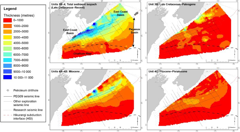
The top of Unit 3B lies at depths of about 8000 m below sea level adjacent to the Hikurangi subduction interface, shallowing to less than 1000 m where it onlaps the Chatham Rise (). The thickness of the unit is generally less than 2500 m and, across much of Pegasus Basin, is less than 1500 m thick (). Unit 3B is likely to be significantly thicker west of the basin in the adjacent Hikurangi margin accretionary wedge due to structural thickening and repetition, and paleo-proximity to clastic sediment supply along the passive margin.
Figure 11 Isopach maps (metres) of total sediment thickness (Late Cretaceous–Recent) and Units 3B to 4C within Pegasus Basin. The apparent increases in stratigraphic thickness west of the Hikurangi subduction interface are probably due, at least in part, to structural repetition within the accretionary margin. The extent of these maps is constrained by the PEG09 seismic survey; Pegasus Basin probably continues east of the area depicted here. Adapted from Bland et al. (Citation2012a, Citation2014b).
Unit 4: Neogene sedimentary rocks
The Hikurangi plate boundary propagated through this part of eastern Zealandia in Early Miocene time. Since then, oblique subduction of the Pacific plate has resulted in downwarping of the Pegasus Basin, providing accommodation space for the large volume of sediments eroded from the rapidly rising land regions further west. The thick package of Neogene sediment is encompassed by Unit 4. The unit has been subdivided into three parts—Units 4A, 4B and 4C—which comprise rocks of inferred Early and Middle Miocene, Late Miocene and Plio-Pleistocene ages, respectively. The thickness of Unit 4 is critically important for the petroleum prospectivity of the basin, being one of the primary controlling factors of the thermal maturity of prospective source rocks within underlying Unit 3.
Unit 4A is tentatively correlated with the Early–Middle Miocene and is differentiated from the underlying Unit 3B as it is much less reflective, suggesting a change in facies from carbonate-rich marls and mudstones to less indurated, possibly more siliciclastic, muddy facies. Such an interpretation is consistent with onshore geology cropping out discussed above. The upper part of Unit 4A is uniformly parallel-bedded, which may indicate a gradual increase in clastic content. Unit 4A is equivalent to the uppermost parts of the Hikurangi Plateau sequence described by Barnes et al. (Citation2010), between their reflectors 7 and 5B. No allochthonous strata consistent with the Early Miocene East Coast Allochthon, a prominent tectonostratigraphic feature of the northern East Coast and Raukumara basins (Stoneley Citation1968; Mazengarb & Speden Citation2000; Sutherland et al. Citation2009), have been identified in Pegasus Basin.
Unit 4B is tentatively dated as Late Miocene. It onlaps a regionally extensive unconformity, inferred by Barnes et al. (Citation2010) and Plaza-Faverola et al. (Citation2012) to be of Late Miocene age (their reflector 5B), although its exact age remains unresolved. The seismic character of Unit 4B suggests it is composed of distal turbidites, consistent with interpretations of the same succession further north along the Hikurangi margin (Barnes et al. Citation2010). The top of Unit 4B lies at depths of 4000–5000 m below sea level (). Collectively, Units 4A and 4B are up to c. 4500 m thick in the Pegasus Basin, and up to 10,000 m thick within the adjacent accretionary wedge of the East Coast Basin (). Such a dramatic increase in thickness across the subduction interface can be attributed to high sediment input and the rapid creation of accommodation space through formation of the numerous transitory slope basins within the accretionary wedge, but also to structural thickening and repetition associated with thrust faulting.
Unit 4C, interpreted to be of Pliocene–Recent age, is up to c. 2700 m thick although it is mostly less than 2000 m thick (). In places it fills bathymetric depressions within an irregular erosion surface, the formation of which may mark the onset of contour currents across this part of the Chatham Rise (Lewis et al. Citation1985). Correlation of seismic units across the transition from rapid deposition of clastic sediments in Pegasus Basin to slow deposition of authigenic carbonates on the Chatham Rise is difficult and complicated by erosion and deposition associated with contour currents (see also Wood & Davy Citation1994). Polygonal faults are common in this package of inferred deep-water fine-grained rocks ().
In marked contrast to the thick Neogene succession (Unit 4) in some parts of Pegasus Basin, where up to 6000 m of strata were deposited (), a relatively thin Neogene succession (c. 1 s TWT) was deposited on the Chatham Rise. Unconformities of probable Pliocene and Pleistocene age occur along the crest of the rise (Barnes Citation1992, Citation1994). These may be attributed to strong current activity associated with large-scale oceanographic events such as establishment of the Circum-Antarctic Current, global changes in sea level and jetting of water through the Mernoo Saddle on the Chatham Rise (Nelson et al. Citation2000).
Neogene rocks are presently being deformed within the Hikurangi subduction system to the west of Pegasus Basin; large anticlinal folds along the tectonic front of the East Coast Basin have formed over blind thrusts that sole out near the top of the Paleogene succession (, , ). In many places offshore from the eastern North Island, the active plate interface of the Hikurangi margin is well defined in seismic reflection data (e.g. Barker et al. Citation2009). Where clearly imaged at the toe of the accretionary system, the modern-day plate interface detachment seems to form preferentially within lowermost parts of Unit 4A (e.g. Barnes et al. Citation2010; Plaza-Faverola et al. Citation2012).
Discussion
Tectonic controls on basin sedimentation
The Pegasus Basin sedimentary sequence has been deposited almost entirely in marine environments. Some Middle–Late Cretaceous deposition on the crest of the adjacent Chatham Rise is interpreted to have occurred in terrestrial and marginal marine environments, analogous to those that prevailed locally in inland Marlborough (e.g. Reay Citation1993). However, by the Paleocene even this area had subsided to near its present-day water depth (e.g. Wood et al. Citation1989). Although some areas may have been repeatedly submerged and then exposed, particularly at the crest of the Chatham Rise—as shown by unconformities within successions cropping out on the Chatham Islands (e.g. Campbell et al. Citation1993; Forsyth et al. Citation2008)—Pegasus Basin has probably remained entirely submerged.
Four main phases of tectonism, as inferred from the seismic stratigraphy of the basin and the geology of surrounding areas, have controlled the formation of the Pegasus Basin:
subduction along the Mesozoic Gondwana margin;
subduction termination in the Albian–Cenomanian (Middle Cretaceous), when the buoyant Hikurangi Plateau encountered and then choked this part of the Gondwana subduction margin;
thermal subsidence of the underlying Hikurangi Plateau during the early Late Cretaceous and Paleocene; and
subsidence resulting from deformation and downwarping of the subducting Pacific plate, outboard of the Neogene–Recent plate boundary and subduction zone.
It is the latter phase that has primarily formed the Pegasus Basin depocentre; the first three phases (Cretaceous–Oligocene) affected much larger regions of the Gondwana and post-Gondwana margin than just the area of Pegasus Basin. Up until the end of phase (3), there was probably very little unique to the area now defined as Pegasus Basin. The basin as defined in this paper primarily owes its origins to phase (4), which has not affected the rest of the Chatham Rise.
Mesozoic Gondwana margin subduction and late Early Cretaceous subduction termination
Pegasus Basin, the adjacent East Coast Basin and the other sedimentary basins of northeast New Zealand (Northeast Slope, Raukumara and Chatham Slope) initially formed within or at the ancient Gondwana subduction margin (Field & Uruski et al. Citation1997; Sutherland et al. Citation2009; Uruski Citation2010). Although many questions regarding the paleo-orientation of the Gondwana subduction margin are yet to be answered, most reconstructions place the above basins in a more-or-less continuous chain along the margin (see ). Some plate reconstructions predict that the present-day East Coast Basin lay to the west or northwest along the Gondwana margin at this time (e.g. King Citation2000; Wood & Stagpoole Citation2007).
Based on the geometry of seismic reflectors, during the Albian–Cenomanian (Middle Cretaceous) the basin margin adjacent to the Chatham Rise is interpreted to have had a relatively narrow shelf and slope, descending to an extensive basin floor at bathyal depths to the north (Uruski & Bland Citation2011; Bland et al. Citation2014b).
The oldest sedimentary rocks present as ‘cover’ within the Pegasus Basin are inferred to be of late Early Cretaceous age, based on their stratigraphic position atop the Early Cretaceous Hikurangi Plateau. There is an apparent paradox, for the seismic character of their lateral equivalents at the basin margin along the Chatham Rise indicates they are a part of the New Zealand ‘basement’. The seismic surveys show this apparent paradox is a continuum from the highly deformed probable metasedimentary rocks regarded as ‘basement’ beneath the Chatham Rise (Unit 1), through laterally equivalent, moderately folded and faulted strata and the little-deformed strata overlying the Hikurangi Plateau (Unit 3A, equivalent to unit ‘MES’ of Davy et al. Citation2008; Barnes et al. Citation2010; Plaza-Faverola et al. Citation2012). This continuum represents the stalled late Mesozoic subduction zone, frozen in time. Imbricated and highly deformed ‘basement’ was well within the accretionary wedge at the time subduction ceased; the moderately folded and faulted equivalents were just within it, and the little-deformed strata further out in the basin were beyond it. Since they are also distant from (i.e. still to reach) the Neogene–modern plate boundary, they have almost no structural overprint and remain little deformed even at the present day.
The Chatham Rise is interpreted to have been subject to subaerial erosion at c. 110–105 Ma (Wood et al. Citation1989; Uruski & Bland Citation2011; Bland et al. Citation2014b), a response to the collision of relatively buoyant, young, over-thickened crust of the Hikurangi Plateau with the Gondwana subduction margin (Davy et al. Citation2008; Reyners Citation2013). This collision is believed to have choked the subduction system in the Chatham Rise–Pegasus segment of the margin, with subduction potentially continuing elsewhere such as along the eastern North Island sector (e.g. Mazengarb & Harris Citation1994). Subduction beneath the Chatham Rise segment is inferred to have shut down over a period of 5–10 million years (Bradshaw Citation1989; Wood & Davy Citation1994; Luyendyk Citation1995; Davy et al. Citation2008). Partial subduction of the Hikurangi Plateau is thought to have been the cause of an estimated 2 km of uplift over the Chatham Rise at this time (Bryan Davy, GNS Science, pers. comm. 2014). Steeply dipping seismic reflections within Unit 1 beneath the upper flank of the Chatham Rise are truncated by this phase of post-depositional erosion. Erosion is also interpreted to have occurred across the crests of large thrust-related highs, further down the flank of rise. These features are interpreted to have been surrounded by low-lying coastal plains, perhaps with associated thin terrestrial deposits.
Latest Cretaceous and Paleogene thermal subsidence
The Late Cretaceous and Paleocene history of sedimentary basins along the west and southeast sides of Zealandia, such as the Northland–Reinga, Taranaki, West Coast and Canterbury–Great South basins, was marked by pronounced phases of crustal extension that effectively formed their depocentres (; Nathan et al. Citation1986; King & Thrasher Citation1996; Gaina et al. Citation1998; Strogen Citation2011). However, there is little evidence that these extensional phases had a major role in the formation and filling of the Pegasus Basin. Several narrow half-graben rift basins, generally less than 20 km wide but often several hundred kilometres long, are present along the crest of the Chatham Rise to the south of Pegasus Basin (Wood et al. Citation1989). The formation of these half-grabens is attributed to subduction of the Hikurangi Plateau beneath the Chatham Rise, and consequential uplift and extension. The absence of evidence for a rift-origin for Pegasus Basin argues against classic McKenzie-style post-rift subsidence (McKenzie Citation1978) for the basin. Instead, the driver for the basin's Late Cretaceous and Paleogene subsidence can be attributed to conductive cooling and subsidence of the underlying Hikurangi Plateau, which would have been warm at the time of its partial subduction beneath Gondwana due to its then-young age and volcanic origin. The area that in Neogene time became the Pegasus Basin was therefore above a cooling and subsiding large igneous province crustal fragment for the 80 million years between cessation of Mesozoic subduction beneath the Chatham Rise and the initiation of subduction along the eastern North Island Hikurangi Margin during the Early Miocene.
The geometry of the Gondwana subduction margin as shown in the seismic data, and in comparison with the modern Hikurangi subduction margin, suggest that in the axial part of the basin the paleo-water-depth at the start of the subsidence phase at c. 105 Ma was likely to have been more than 1000 m. The crest of the Chatham Rise lay at shelf depths, with slope environments to the north (Wood et al. Citation1989; Uruski & Bland Citation2011).
Seismically derived thickness estimates (e.g. ) and the reflection character of Unit 3B indicate low sedimentation rates from the Late Cretaceous until the renewal of active deformation in the earliest Miocene. The primary source of sediment through this time was likely to have been from an eroding Chatham Rise, although a Marlborough-derived component cannot be discounted. As the size of surrounding land areas decreased, the clastic sediment supply into the area of present-day Pegasus Basin waned. By the Oligocene there was little land anywhere on the New Zealand continent (e.g. Landis et al. Citation2008; Strogen et al. Citation2014) and clastic sediment supply into Pegasus Basin had effectively ceased; deposition is inferred to have been dominated by fine-grained hemipelagic carbonates. Results from ODP site 1124, about 600 km northeast of Pegasus Basin, show that sediments deposited distal to the fossil Gondwana subduction margin during the Late Cretaceous–Late Eocene comprise mudstones and cherts, with a change to chalk in the Oligocene (Shipboard Scientific Party Citation1999).
In the Middle Eocene, a major change in plate motion and the cessation of seafloor spreading in the Tasman Sea was followed by the onset of seafloor spreading to the southeast of New Zealand and the formation of the Emerald Basin, which propagated north from the Emerald Basin into the New Zealand continental block (; Kamp Citation1986; King Citation2000). Coevally, a southwest-dipping subduction zone propagated south from the New Caledonia region into the Northland region (Mortimer et al. Citation2007; Bache et al. Citation2012) and, by the Early Miocene, into the East Coast Basin, perhaps as a consequence of slab roll-back. These two tectonic zones at either end of the Zealandia continental block were eventually linked during the earliest Miocene by a through-going transform fault system: the Alpine Fault and associated structures.
The development of a subduction system beneath Northland, and eventually eastern North Island, suggests that the former Cretaceous Gondwana subduction margin was partly exploited, but not where the Hikurangi Plateau had locked the former plate boundary beneath the Chatham Rise and Pegasus Basin. There is as yet no convincing evidence for deformation of Eocene age in Pegasus Basin, though distal tectonic events may have resulted in an increased supply of clastic material to the basin. By the earliest Miocene the basin lay at bathyal water depths of 200 m to more than 1000 m (; Uruski & Bland Citation2011; Bland et al. Citation2014b). Continental slope paleoenvironments were present along the northern slope of the Chatham Rise, and basin-floor environments in axial parts of the basin (Uruski & Bland Citation2011).
Neogene Plate boundary development and Pacific Plate subduction
Since the early Late Cretaceous, the Hikurangi Plateau and Chatham Rise have been locked together and this part of the fossil subduction interface, now trending west–east, has not been reactivated (Davy et al. Citation2008; Hoernle et al. Citation2010; Reyners Citation2013). By Late Miocene time, the cooling Hikurangi Plateau had lost sufficient buoyancy for it to be subducted westwards beneath the southern North Island along the modern Hikurangi margin (Davy Citation1992; Reyners et al. Citation2011; Reyners Citation2013). The Neogene depocentre of Pegasus Basin formed at the transition between subduction and strike-slip faulting, where the plate boundary changes from ocean–continent to continent–continent collision.
The paleo-geography of Pegasus Basin at 25 Ma is interpreted to have been similar to that at 105 Ma, although by this time the Chatham Rise to the south had subsided and the entire region was submarine (Uruski & Bland Citation2011). Downwarping of underlying basement in the west of the basin during the Neogene has created extra accommodation space for sediment. Source areas for the Neogene sediments of Pegasus Basin are likely to have included the southern part of North Island, the northern part of South Island and, from the Late Miocene, the Southern Alps. The continental slope to the northwest of Pegasus Basin is commonly incised by broad canyons, which are likely to have been sediment conduits at times. For much of Neogene time, Cook Strait Canyon was a major conduit for deposition into Pegasus Basin, providing sediments eroded from north and south of Cook Strait. Sediments eroded from the Canterbury segment of the Southern Alps are presently carried by broad, braided river systems across the Canterbury Plains and into the offshore Canterbury Basin. During glacial periods, northwards-flowing currents carried a proportion of these sediments across Mernoo Saddle at the west end of the Chatham Rise and into the Pegasus Basin (Barnes Citation1992, Citation1994). The sediment types associated with this depositional system range from background hemipelagic mud to coarse-grained sands (Lewis & Pantin Citation2002), the latter typical of turbidite systems. Other smaller canyons were also active in offshore Wairarapa.
The Marlborough region has probably lain close to the point where Chatham Rise impinges on the subduction interface since inception of the modern subduction system in the earliest Miocene. Uplift of the Inland Kaikoura Range in the Early Miocene contributed large amounts of coarse-grained detritus to surrounding basins, best illustrated by the Great Marlborough Conglomerate (e.g. Lewis et al. Citation1980). Coarse-grained sediments may therefore have also been redeposited in the deeper parts of Pegasus Basin by mass-flow processes.
Seismic transects across the modern Hikurangi margin show a transition from highly deformed Late Cretaceous, Paleogene and Neogene rocks of the East Coast Basin, through less-deformed equivalents in more distal parts of the accretionary wedge, into the little-deformed lateral equivalents of the Pegasus Basin which, at the present-day, remain outboard of the deformation front (e.g. Bland et al. Citation2014a). The continuum seen in the Neogene–Recent succession is also seen in the fossil subduction front preserved at the southern margin of the Pegasus Basin; complexly deformed and imbricated Torlesse rocks are seen to pass laterally into moderately deformed equivalents, inferred to be of Early Cretaceous age, outboard of which are little-deformed coeval rocks that never reached the contemporary deformation front (Davy et al. Citation2008). Recognition of this structural transition is the key to understanding the distinction between Early Cretaceous ‘basement’ and ‘cover’ rocks cropping out in Marlborough, Wairarapa and Raukumara Peninsula (see Barnes Citation1990; also Begg & Johnston Citation2000; Mazengarb & Speden Citation2000; Lee & Begg Citation2002; Rattenbury et al. Citation2006).
Conclusions
Interpretation of the stratigraphy of the Pegasus Basin became more feasible following the acquisition of the New Zealand Government's PEG09 seismic reflection dataset. Uniquely, northwest–southeast-oriented seismic lines across the basin reveal two opposing subduction systems. At the southern margin of the basin is a remarkable well-preserved fossil part of the ancient subduction zone of the Gondwana margin, on which subduction ceased at about 110–105 Ma, while at the western margin of the basin is the deformation zone associated with the Neogene–Recent west-dipping Hikurangi subduction zone active at the present day.
The sedimentary basin fill may be as thick as c. 9000 m, and consists entirely or almost entirely of marine rocks of late Early Cretaceous–Recent age. The basin lies outboard of (i.e. east of) the modern Hikurangi subduction deformation front, and therefore the basin fill has been little deformed by the Neogene convergent margin tectonics that have pervasively deformed the adjacent East Coast Basin.
The key observations from this study of Pegasus Basin are as follows:
A generally simple stratigraphy exists, consisting of four tectonostratigraphic units:
(1) Unit 1: Torlesse Composite Terrane metasedimentary ‘basement';
(2) Unit 2: Early Cretaceous Hikurangi Plateau basement, comprising a partially subducted remnant of a large igneous province;
(3) Unit 3: syn-subduction late Early Cretaceous metasedimentary rocks (Unit 3A) and late Early Cretaceous and Paleogene sedimentary rocks deposited within a thermally subsiding continental margin (Unit 3B); and
(4) Unit 4: Neogene–Recent basin fill, deposited into a tectonically quiescent basin adjacent to, but outboard from, an active convergent margin.
Unit 3B: deposited during a long-lived thermal subsidence phase, is thin, indicating a limited clastic sediment supply and implying submergence of the basin margin for much of this period.
A very thick Neogene succession is present, particularly in the west of the basin, and appears to have been fed by a long-lived channel system that has carried sediments from the west and southwest into Pegasus Basin.
The Cretaceous Gondwana subduction margin within Pegasus Basin was not reactivated during the renewal of subduction beneath New Zealand in the Neogene, and the Hikurangi Plateau and Chatham Rise appear to be locked. Because the Gondwana subduction margin was not reactivated, Pegasus Basin has remained well preserved and little deformed.
These observations of Pegasus Basin geology have implications for understanding eastern New Zealand's tectonic history and the petroleum prospectivity of the basin. Cretaceous to present-day tectonics in eastern New Zealand have been greatly influenced by the Hikurangi Plateau; its arrival was the cause of cessation of subduction along the Pegasus Basin–Chatham Rise part of the Gondwana margin, as it essentially choked this part of the subduction margin. Pegasus Basin geology also helps us to understand the relationship between ‘basement’ and ‘cover’ rocks in eastern New Zealand, particularly the lateral continuum between strata within Units 1 and 3. An analogous transition can be seen at the modern plate boundary from the deformed Neogene strata of the East Coast Basin accretionary wedge, east across the deformation front to their undeformed lateral equivalents in the Pegasus Basin. Additionally, the little-deformed character of Pegasus Basin fill provides a window into the likely thickness and character of strata that can be expected to be encountered in the adjacent East Coast Basin, the latter having been pervasively deformed during the Neogene.
Supplementary data
Figure S1. High-resolution version of seismic line PEG09-25, as depicted in .
Figure S2. High-resolution version of part of seismic line PEG09-21, as depicted in .
Figure S3. High-resolution version of seismic line SAHKE-01, as depicted in .
Figure S4. High-resolution version of seismic line PEG09-08, as depicted in .
Figure S5. High-resolution version of seismic line PEG09-17, as depicted in .
Figure S5. High-resolution version of seismic line PEG09-17, as depicted in Figure 9.
Download PDF (97.1 MB)Figure S4. High-resolution version of seismic line PEG09-08, as depicted in Figure 8.
Download PDF (78.6 MB)Figure S3. High-resolution version of seismic line SAHKE-01, as depicted in Figure 7.
Download PDF (49.4 MB)Figure S2. High-resolution version of part of seismic line PEG09-21, as depicted in Figure 6.
Download PDF (31.4 MB)Figure S1. High-resolution version of seismic line PEG09-25, as depicted in Figure 4.
Download PDF (41.9 MB)Acknowledgements
New Zealand Petroleum and Minerals, of the Ministry of Business, Innovation and Employment, commissioned the projects on which this study was based and we gratefully acknowledge their support. Ray Wood provided useful comments on early stages of this study. Dominic Strogen undertook some seismic interpretation on key framework lines. Nick Mortimer is thanked for making us aware of igneous rock analyses regarding potential onshore Hikurangi Plateau equivalents. Bryan Davy and Tusar Sahoo provided useful reviews of early versions of this paper. Philip Barnes and an anonymous reviewer made many helpful comments and we thank them for their valuable reviews.
Associate Editor: Dr Kari Bassett.
Disclosure statement
No potential conflict of interest was reported by the authors.
Additional information
Funding
References
- Adams CJ, Graham IJ 1996. Metamorphic and tectonic geochronology of the Torlesse Terrane, Wellington, New Zealand. New Zealand Journal of Geology and Geophysics 39: 157–180. doi: 10.1080/00288306.1996.9514703
- Bache F, Sutherland R, Stagpoole VM, Herzer RH, Collot J, Rouillard P 2012. Stratigraphy of the southern Norfolk Ridge and the Reinga Basin: a record of initiation of Tonga-Kermadec-Northland subduction in the southwest Pacific. Earth and Planetary Science Letters 321/322: 41–53. doi: 10.1016/j.epsl.2011.12.041
- Ballance PF 1993. The New Zealand Neogene forearc basins. In: Ballance PF ed. Sedimentary basins of the world 2. South Pacific sedimentary basins. Amsterdam, Elsevier. Pp. 177–191.
- Barker DHN, Sutherland R, Henrys S, Bannister S 2009. Geometry of the Hikurangi subduction thrust and upper plate, North Island, New Zealand. Geochemistry Geophysics. Geosystems 10, Q02007. doi:10.1029/2008GC002153.
- Barnes PM 1990. Provenance of Cretaceous accretionary wedge sediments: the Mangapokia Formation, Wairarapa, New Zealand. New Zealand Journal of Geology and Geophysics 33: 125–135. doi: 10.1080/00288306.1990.10427578
- Barnes PM 1992. Mid-bathyal current scours and sediment drifts adjacent to the Hikurangi deep-sea turbidite channel, eastern New Zealand: Evidence from echo character mapping. Marine Geology 106: 169–187. doi: 10.1016/0025-3227(92)90128-5
- Barnes PM 1994. Pliocene-Pleistocene depositional units on the continental slope off central New Zealand: control by slope currents and global climate cycles. Marine Geology 117: 155–175. doi: 10.1016/0025-3227(94)90012-4
- Barnes PM, Korsch RJ 1990. Structural analysis of a middle Cretaceous accretionary wedge, Wairarapa, New Zealand. New Zealand Journal of Geology and Geophysics 33: 355–375. doi: 10.1080/00288306.1990.10425693
- Barnes PM, Korsch RJ 1991. Melange and related structures in Torlesse accretionary wedge, Wairarapa, New Zealand. New Zealand Journal of Geology and Geophysics 34: 517–532. doi: 10.1080/00288306.1991.9514487
- Barnes PM, Lamarche G, Bialas J et al. 2010. Tectonic and geological framework for gas hydrates and cold seeps on the Hikurangi subduction margin, New Zealand. Marine Geology 272: 26–48. doi: 10.1016/j.margeo.2009.03.012
- Barnes PM, de Lepinay BM 1997. Rates and mechanics of rapid frontal accretion along the very obliquely convergent southern Hikurangi margin, New Zealand. Journal of Geophysical Research, Solid Earth 102: 24931–24952. doi: 10.1029/97JB01384
- Barnes PM, de Lepinay BM, Collot J, Delteil J, Audru J 1998. Strain partitioning in the transition area between oblique subduction and continental collision, Hikurangi margin, New Zealand. Tectonics 17: 534–557. doi: 10.1029/98TC00974
- Barnes PM, Nicol A 2004. Formation of an active thrust triangle zone associated with structural inversion in a subduction setting, eastern New Zealand. Tectonics 23: TC1015. doi:10.1029/2002TC001449
- Barnes PM, Nicol A, Harrison T 2002. Late Cenozoic evolution and earthquake potential of an active listric thrust complex above the Hikurangi subduction zone, New Zealand. Geological Society of America Bulletin 114: 1379–1405. doi: 10.1130/0016-7606(2002)114<1379:LCEAEP>2.0.CO;2
- Bassett KN, Orlowski R 2004. Pahau Terrane type locality: fan delta in an accretionary prism trench-slope basin. New Zealand Journal of Geology and Geophysics 47: 603–623. doi: 10.1080/00288306.2004.9515079
- Begg JG, Johnston MR 2000 (compilers). Geology of the Wellington area. Institute of Geological and Nuclear Sciences 1:250 000 geological map 10. Lower Hutt, New Zealand: Institute of Geological and Nuclear Sciences Ltd. 64 p. + 1 folded map.
- Billen MI, Stock J 2000. Morphology and origin of the Osbourn Trough. Journal of Geophysical Research 105: 13481–13489. doi: 10.1029/2000JB900035
- Bland KJ, Field BD, Griffin AG et al. 2012a. Play-based assessment of the Pegasus and East Coast Basins. GNS Science data series 9b. 1 CD: http://data.gns.cri.nz/dataportal/
- Bland KJ, Hill MG, Strogen DP et al. 2014a. New Zealand National Seismic Framework: Reinga-Northland, Taranaki, Canterbury-Great South, Bounty Trough, and Pegasus-East Coast-Raukumara basins. GNS Science consultancy report 2013/254. 55 p. + 51 Enclosures and 1 Kingdom seismic project.
- Bland KJ, Lamarche G, Anderson O et al. 2014b. Pegasus Basin Petroleum Prospectivity Screening Report, GNS Science Consultancy Report 2014/103. In: Pegasus Basin Screening Survey Final Report. Ministry of Business, Innovation and Employment (MBIE), New Zealand Unpublished Petroleum Report PR4915: 139 p.
- Bland KJ, Uruski CI, Isaac MJ 2012b. Oil and gas in eastern New Zealand: Fresh insights from the Pegasus Basin. AAPG Search and Discovery Article #10440 2012. http://www.searchanddiscovery.com/author.html#Bi-Bo
- Bradshaw JD 1989. Cretaceous geotectonic patterns in the New Zealand region. Tectonics 8: 803–820. doi: 10.1029/TC008i004p00803
- Browne GH, Laird MG, Field BD 2005. Field Trip 5B: Stratigraphic and sedimentological teasers, Kaikoura Peninsula, Marlborough. In: Pettinga JR, Wandres AM eds. Field Trip Guides, Geological Society of New Zealand 50th Annual Conference. Geological Society of New Zealand Miscellaneous Publication 119B. Pp. 129–140.
- Campbell HJ, Andrews PB, Beu AG et al. 1993. Cretaceous–Cenozoic geology and biostratigraphy of the Chatham Islands, New Zealand. Institute of Geological & Nuclear Sciences monograph 2. Lower Hutt, Institute of Geological & Nuclear Sciences Ltd. 269 p. + 1 map.
- Carter RM et al. 1999. Site 1124; Rekohu Drift; from the K/T boundary to the Deep Western Boundary Current. Proceedings of the Ocean Drilling Program; initial reports; Southwest Pacific gateways; covering Leg 181 of the cruises of the drilling vessel JOIDES Resolution; Sydney, Australia, to Wellington, New Zealand; sites 1119–1125; 11 August–8 October 1998, Proceedings of the Ocean Drilling Program Initial Reports 181. 137 p.
- Collot J-Y, Delteil J, Lewis KB et al. 1996. From oblique subduction to intra-continental transpression: structures of the southern Kermadec-Hikurangi margin from multi-beam bathymetry, side-scan sonar and seismic reflection. Marine Geophysical Researches 18: 357–381. doi: 10.1007/BF00286085
- Crampton JS 1997. The Cretaceous stratigraphy of southern Hawke's Bay–Wairarapa region. Institute of Geological & Nuclear Sciences science report 97/08. Lower Hutt, Institute of Geological & Nuclear Sciences. 92 p.
- Crampton JS, Laird MG 1997. Burnt Creek Formation and Late Cretaceous basin development in Marlborough, New Zealand. New Zealand Journal of Geology and Geophysics 40: 199–222. doi: 10.1080/00288306.1997.9514753
- Crampton J, Laird M, Nicol A, Townsend D, Van Dissen R 2003. Palinspastic reconstructions of southeastern Marlborough, New Zealand, for Late Cretaceous to Eocene times. New Zealand Journal of Geology and Geophysics 46: 153–175. doi: 10.1080/00288306.2003.9515002
- Davey FJ, Hampton M, Childs J, Fisher MA, Lewis K, Pettinga JR 1986. Structure of a growing accretionary prism, Hikurangi margin, New Zealand. Geology 14: 663–666. doi: 10.1130/0091-7613(1986)14<663:SOAGAP>2.0.CO;2
- Davy BW 1992. The influence of subducting plate buoyancy on subduction of the Hikurangi-Chatham Plateau beneath the North Island, New Zealand. In: Watkins J et al. eds. Advances in the geology and geophysics of the continental margins. Tulsa, Oklahoma, American Association of Petroleum Geologists. Pp. 75–91.
- Davy B 2014. Rotation and offset of the Gondwana convergent margin in the New Zealand region following Cretaceous jamming of Hikurangi Plateau large igneous province subduction. Tectonics 33: 1577–1595. doi: 10.1002/2014TC003629
- Davy BW, Hoernle K, Werner R 2008. Hikurangi Plateau: crustal structure, rifted formation, and Gondwana subduction history. Geochemistry Geophysics Geosystems 9: Q07004. doi:10.1029/2007GC001855
- Davy BW, Uruski CI 2002. Results of the 2001 deep seismic survey of the Chatham Rise and Hikurangi Plateau and implications for petroleum exploration. In: 2002 New Zealand Petroleum Conference Proceedings. 24–27 February 2002. Wellington, Ministry of Economic Development. Pp. 381–390.
- Davy BW, Wood RA 1994. Gravity and magnetic modelling of the Hikurangi Plateau. Marine Geology 118: 139–151. doi: 10.1016/0025-3227(94)90117-1
- Field BD, Strogen D, Zhu H et al. 2014. An ArcGIS project on seal rocks of the New Zealand region. GNS Science Consultancy Report 2014/232. 78 p.
- Field BD, Uruski CI et al. 1997. Cretaceous–Cenozoic geology and petroleum systems of the East Coast region, New Zealand. Institute of Geological and Nuclear Sciences monograph 19. Lower Hutt, Institute of Geological and Nuclear Sciences Limited. 301 p. + 7 enclosures.
- Forsyth PJ, Barrell DJA, Jongens R (compilers) 2008. Geology of the Christchurch area. Institute of Geological & Nuclear Sciences 1:250,000 geological map 16. Lower Hutt, GNS Science. 67 p. + 1 folded map.
- Fulthorpe CS, Carter RM, Miller KG, Wilson J 1996. Marshall Paraconformity: a mid-Oligocene record of inception of the Antarctic Circumpolar Current and coeval glacio-eustatic lowstand? Marine and Petroleum Geology 13: 61–77. doi: 10.1016/0264-8172(95)00033-X
- Gaina C, Müller RD, Royer J-Y, Stock J, Hardebeck J, Symonds P 1998. The tectonic history of the Tasman Sea: A puzzle with thirteen pieces. Journal of Geophysical Research 103: 12413–12433. doi: 10.1029/98JB00386
- Henrys S, Wech A, Sutherland R et al. 2013. SAHKE geophysical transect reveals crustal and subduction zone structure at the southern Hikurangi margin, New Zealand. Geochemistry, Geophysics, Geosystems 14: 2063–2083. doi: 10.1002/ggge.20136
- Hines BR, Kulhanek DK, Hollis CJ, Atkins CB, Morgans HEG 2013. Paleocene–Eocene stratigraphy and paleoenvironment at Tora, Southeast Wairarapa, New Zealand. New Zealand Journal of Geology and Geophysics 56: 243–262. doi: 10.1080/00288306.2013.836112
- Hoernle K, Hauff F, van den Bogaard P, Werner R, Mortimer N, Geldmacher J et al. 2010. Age and geochemistry of volcanic rocks from the Hikurangi and Manihiki oceanic plateaus. Geochimica et Cosmochimica Acta. doi:10.1016/j.gca.2010.09.030;7196–7219
- Hoernle K, White JDL, van den Bogaard P, Hauff F, Coombs DS, Werner R et al. 2006. Cenozoic intraplate volcanism on New Zealand: upwelling induced by lithospheric removal. Earth and Planetary Science Letters 248(1/2): 350–367. doi: 10.1016/j.epsl.2006.06.001
- Hollis CJ 2003. The Cretaceous/Tertiary boundary event in New Zealand: profiling mass extinction. New Zealand Journal of Geology and Geophysics 46: 307–321. doi: 10.1080/00288306.2003.9515011
- Hollis CJ, Dickens GR, Field BD, Jones CM, Strong CP 2005a. The Paleocene–Eocene transition at Mead Stream, New Zealand: a southern Pacific record of early Cenozoic global change. Palaeogeography, Palaeoclimatology, Palaeoecology 215: 313–343. doi: 10.1016/j.palaeo.2004.09.011
- Hollis CJ, Field BD, Jones CM, Strong CP, Wilson GJ, Dickens GR 2005b. Biostratigraphy and carbon isotope stratigraphy of uppermost Cretaceous-lower Cenozoic Muzzle Group in middle Clarence valley, New Zealand. Journal of the Royal Society of New Zealand 35: 345–383. doi: 10.1080/03014223.2005.9517789
- Hollis CJ, Manzano-Kareah K 2005. Source Rock Potential of the East Coast Basin. Ministry of Economic Development New Zealand unpublished petroleum report PR3179. 158 p. + 1 enclosure.
- Hollis CJ, Tayler MJS, Andrew B et al. 2014. Organic-rich sedimentation in the South Pacific Ocean associated with Late Paleocene climatic cooling. Earth-Science Reviews 134: 81–97. doi: 10.1016/j.earscirev.2014.03.006
- James NP, Jones B, Nelson CS, Campbell HJ, Titjen J 2011. Cenozoic temperate and sub-tropical carbonate sedimentation on an oceanic volcano—Chatham Islands, New Zealand. Sedimentology 58: 1007–1029. doi: 10.1111/j.1365-3091.2010.01193.x
- Kamp PJJ 1986. The mid-Cenozoic Challenger Rift system of western New Zealand and its implications for the age of Alpine Fault inception. Geological Society of America Bulletin 97: 255–281. doi: 10.1130/0016-7606(1986)97<255:TMCRSO>2.0.CO;2
- King PR 2000. Tectonic reconstructions of New Zealand 40 Ma to the present. New Zealand Journal of Geology and Geophysics 43: 611–638. doi: 10.1080/00288306.2000.9514913
- King PR, Thrasher GP 1996. Cretaceous-Cenozoic geology and petroleum systems of the Taranaki Basin, New Zealand. Institute of Geological & Nuclear Sciences monograph 13. Lower Hutt: Institute of Geological & Nuclear Sciences Limited. 243 p.
- Landis CA, Campbell HJ, Begg JG, Mildenhall DC, Paterson AM, Trewick SA 2008. The Waipounamu Erosion Surface: questioning the antiquity of the New Zealand land surface and terrestrial fauna and flora. Geological Magazine 145: 173–197. doi: 10.1017/S0016756807004268
- Lee JM, Begg JG (compilers) 2002. Geology of the Wairarapa area. Institute of Geological & Nuclear Sciences 1:250 000 geological map 11. Lower Hutt, GNS Science. 66 p. + 1 folded map.
- Lee JM, Bland KJ, Townsend DB, Kamp PJJ (compilers) 2011. Geology of the Hawke's Bay area. Institute of Geological & Nuclear Sciences 1:250 000 geological map 8. Lower Hutt, GNS Science. 93 p. + 1 folded map.
- Lewis KB 1994. The 1500-km-long Hikurangi Channel: trench-axis channel that escapes its trench, crosses a plateau, and feeds a fan drift. Geo-marine Letters 14(1): 19–28.
- Lewis KB 1985. New rock samples and cores from Hikurangi Margin geology cruise 1121. In: Lewis KB (compiler). New seismic profiles, cores and dated rocks from the Hikurangi Margin, New Zealand, 1985. NZOI Oceanographic Field report 22. DSIR Division of Marine and Freshwater Science. Pp. 37–49.
- Lewis KB, Bennett DJ, Herzer RH, von der Borch CC 1985. Seismic stratigraphy and structure adjacent to an evolving plate boundary, Western Chatham Rise, New Zealand. Initial reports of the Deep Sea Drilling Project V.XC. Chapter 38. Washington, U.S. Government Printing Office. Pp. 1325–1337.
- Lewis KB, Collot J-Y, Lallemand SE 1998. The dammed Hikurangi Trough: a channel-fed trench blocked by subducting seamounts and their wakewake avalanches (New Zealand-France GeodyNZ Project). Basin Research 10: 441–468. doi: 10.1046/j.1365-2117.1998.00080.x
- Lewis DW, Laird MG, Powell RG 1980. Debris flow deposits of Lower Miocene age, Deadman Stream, Marlborough, New Zealand. Sedimentary Geology 27: 83–118. doi: 10.1016/0037-0738(80)90032-9
- Lewis KB, Pantin HM 2002. Channel-axis, overbank and drift sediment waves in the Southern Hikurangi Trough, New Zealand. Marine Geology 192: 123–151. doi: 10.1016/S0025-3227(02)00552-2
- Lewis KB, Pettinga JR 1993. The emerging, imbricate frontal wedge of the Hikurangi Margin. In: Ballance PF ed. South Pacific sedimentary basins. Sedimentary basins of the world 2. Amsterdam, Elsevier Science Publishers. Pp. 225–250.
- Luyendyk BP 1995. Hypothesis for Cretaceous rifting of east Gondwana caused by subducted slab capture, not ridge collision. In: VII International Symposium on Antarctic Earth Sciences: Siena (Italy), 10–15 September 1995: abstracts, plenary lectures, oral and poster sessions. Siena, Universita di Siena. Pp. 253.
- Mazengarb C, Harris DHM 1994. Cretaceous stratigraphic and structural relations of Raukumara Peninsula, New Zealand: stratigraphic patterns associated with the migration of a thrust system. Annales Tectonicae 8: 100–108.
- Mazengarb C, Speden IG (compilers) 2000. Geology of the Raukumara area. Institute of Geological & Nuclear Sciences 1:250 000 geological map 6. Lower Hutt, GNS Science. 60 p. + 1 map.
- McKenzie D 1978. Some remarks on the development of sedimentary basins. Earth and Planetary Science Letters 40: 25–32. doi: 10.1016/0012-821X(78)90071-7
- Moore PR 1988. Stratigraphy, composition, and environment of deposition of the Whangai Formation and associated Late Cretaceous-Paleocene rocks, eastern North Island, New Zealand. New Zealand Geological Survey bulletin 100. Lower Hutt, New Zealand Geological Survey. 82 p.
- Morgans HEG, Hollis CJ 1999. Cretaceous-Paleogene stratigraphy of southern Hawkes Bay: K/T boundary, Late Paleocene and Oligocene event horizons. In: Palmer A ed. GSNZ Inc 1999 Annual Conference, 29 November–1 December, Massey University, Palmerston North field trip guides. Geological Society of New Zealand miscellaneous publication 107B. Pp. 230–248.
- Mortimer N 1994. Origin of the Torlesse Terrane and coeval rocks, North Island, New Zealand. International Geological Review 36: 891–910. doi: 10.1080/00206819409465494
- Mortimer N 2004. New Zealand's geological foundations. Gondwana Research 7: 261–272. doi: 10.1016/S1342-937X(05)70324-5
- Mortimer N, Campbell HJ 2014. Zealandia: our continent revealed. Auckland, Penguin. 271 p.
- Mortimer N, Davey FJ, Melhuish A, Yu J, Godfrey NJ 2002. Geological interpretation of a deep seismic reflection profile across the Eastern Province and Median Batholith, New Zealand: crustal architecture of an extended Phanerozoic convergent orogen. New Zealand Journal of Geology and Geophysics 45: 349–363. doi: 10.1080/00288306.2002.9514978
- Mortimer N, Herzer RH, Gans PB, Laporte-Magoni C, Calvert AT, Bosch D 2007. Oligocene-Miocene tectonic evolution of the South Fiji Basin and Northland Plateau, SW Pacific Ocean: evidence from petrology and dating of dredged rocks. Marine Geology 237: 1–24. doi: 10.1016/j.margeo.2006.10.033
- Mortimer N, Parkinson D 1996. Hikurangi Plateau: A Cretaceous large igneous province in the southwest Pacific Ocean. Journal of Geophysical Research, 101: 687–696. doi: 10.1029/95JB03037
- Mortimer N, Rattenbury MS, King PR et al. 2014. High-level lithostratigraphic scheme for New Zealand rocks. New Zealand Journal of Geology and Geophysics 57: 402–419. doi: 10.1080/00288306.2014.946062
- Nathan S, Anderson HJ, Cook RA, Herzer RH, Hoskins RH, Raine JI, et al. 1986. Cretaceous and Cenozoic sedimentary basins of the West Coast region, South Island, New Zealand. New Zealand Geological Survey basin studies 1. Wellington: SIPC, DSIR. 89 p.
- Nelson CS, Hendy IL, Neil HL, Hendy CH, Weaver PPE 2000. Last glacial jetting of cold waters through the Subtropical Convergence zone in the Southwest Pacific off eastern New Zealand, and some geological implications. Palaeogeography, Palaeoclimatology, Palaeoecology 156: 103–121. doi: 10.1016/S0031-0182(99)00134-0
- NZP&M (New Zealand Petroleum & Minerals) 2013. New Zealand Petroleum Basins. Wellington, New Zealand Petroleum & Minerals. 108 p.
- Plaza-Faverola A, Klaeschen D, Barnes P, Pecher IA, Henrys SA, Mountjoy J 2012. Evolution of fluid expulsion and concentrated hydrate zones across the southern Hikurangi subduction margin, New Zealand: an analysis from depth migrated seismic data. Geochemistry Geophysics Geosystems 13(8): Q08018. 21 p. doi: 10.1029/2012GC004228
- Rattenbury MS, Townsend DB, Johnston MR (compilers) 2006. Geology of the Kaikoura area. Institute of Geological & Nuclear Sciences 1:250,000 geological map 13. Lower Hutt, GNS Science. 70 p. + 1 folded map.
- Reay MB 1993. Geology of the middle part of the Clarence Valley. Institute of Geological & Nuclear Sciences geological map 10. Lower Hutt, Institute of Geological & Nuclear Sciences. 144 p. + 1 map.
- Reyners M 2013. The central role of the Hikurangi Plateau in the Cenozoic tectonics of New Zealand and the Southwest Pacific. Earth and Planetary Science Letters 361: 460–468. doi: 10.1016/j.epsl.2012.11.010
- Reyners M, Eberhart-Phillips D, Bannister S 2011. Tracking repeated subduction of the Hikurangi Plateau beneath New Zealand. Earth and PSLPlanetary Science Letters 311: 165–171. doi: 10.1016/j.epsl.2011.09.011
- RPS Energy 2010. Pegasus Basin, Bounty Trough and SAHKE seismic—Report on contractor's performance during 2D seismic survey 13th November 2009 to 30th March 2010. Ministry of Economic Development New Zealand unpublished petroleum report PR 4158.
- Schiøler P, Rogers K, Sykes R et al. 2010. Palynofacies, organic geochemistry and depositional environment of the Tartan Formation (Late Paleocene), a potential source rock in the Great South Basin, New Zealand. Marine and Petroleum Geology 27: 351–369. doi:10.1016/j.marpetgeo.2009.09.006
- Shipboard Scientific Party 1999. Site 1124: Rekohu Drift—from the K/T boundary to the Deep Western Boundary Current. In: Carter RM, McCave IN, Richter C et al. eds. Proceedings of the Ocean Drilling Project, initial reports leg 181. College Station, Texas, Ocean Drilling Program. Pp. 1–137. doi:10.2973/odp.proc.ir.181.108.2000
- Sikora PJ, Bergen JA 2004. Lower Cretaceous planktonic foraminiferal and nannofossil biostratigraphy of Ontong Java Plateau sites from DSDP Leg 30 and ODP Leg 192. In: Fitton JG, Mahoney JJ, Wallace PJ, Saunders AD eds. Origin and Evolution of the Ontong Java Plateau. London, Geological Society London Special Publication 229. Pp. 83–111.
- Stagpoole V, Field B, Sutherland R Uruski CI, Zink K 2008. Petroleum prospectivity of the Raukumara Basin, New Zealand. GNS Science consultancy report 2008/111. Ministry of Economic Development New Zealand unpublished petroleum report PR 3921. 111 p.
- Stoneley R 1968. A lower Tertiary décollement on the East Coast, North Island, New Zealand. New Zealand Journal of Geology and Geophysics 11: 128–156. doi: 10.1080/00288306.1968.10423680
- Strogen DP (compiler) 2011. Updated paleogeographic maps for the Taranaki Basin and surrounds. GNS science report 2010/53. Lower Hutt, GNS Science. 83 p.
- Strogen DP, Bland KJ, Nicol A, King PR 2014. Paleogeography of the Taranaki Basin region during the latest Eocene–Early Miocene and implications for the 'total drowning' of Zealandia. New Zealand Journal of Geology and Geophysics 57: 110–127. doi: 10.1080/00288306.2014.901231
- Suggate RP, Stevens GR, Te Punga MT eds. 1978. The Geology of New Zealand. Wellington, Government Printer.
- Sutherland R, Stagpoole V, Uruski C et al. 2009. Reactivation of tectonics, crustal underplating, and uplift after 60 Myr of passive subsidence, Raukumara Basin, Hikurangi-Kermadec fore arc, New Zealand: Implications for global growth and recycling of continents. Tectonics 28: TC5017. 23 p. doi:10.1029/2008TC002356
- Taylor B 2006. The single largest oceanic plateau: Ontong Java-Manihiki-Hikurangi. Earth and Planetary Science Letters 241: 372–380. doi: 10.1016/j.epsl.2005.11.049
- Townsend DB 2001. Neogene evolution of the Pacific-Australia plate boundary zone in NE Marlborough, South Island, New Zealand. Unpublished PhD thesis, Victoria University of Wellington, Wellington, New Zealand.
- Uruski CI 2010. New Zealand's deepwater frontier. Marine and Petroleum Geology 27: 2005–2026. doi: 10.1016/j.marpetgeo.2010.05.010
- Uruski CI 2012. Deepwater frontier basins: New Zealand. In: Roberts DG, Bally AW eds. Regional geology and tectonics: Phanerozoic passive margins, cratonic basins and global tectonic maps. Burlington, Elsevier. Pp. 487–532.
- Uruski CI, Bland K 2011. Pegasus Basin and the Prospects for Oil and Gas. GNS Science consultancy report 2010/291. Ministry of Economic Development New Zealand unpublished petroleum report PR4326. 128 p.
- Uruski CI, Jones C 2008. Preliminary desk-top study of available marine and geophysical data in the Pegasus Sub-basin, East Coast, North Island. GNS Science consultancy report 2008/30. 19 p.
- Wood RA, Andrews PB, Herzer RH et al. 1989. Cretaceous and Cenozoic geology of the Chatham Rise region, South Island, New Zealand. New Zealand Geological Survey basin studies 3. Lower Hutt, New Zealand Geological Survey. 75 p.
- Wood RA, Davy B 1994. The Hikurangi Plateau. Marine Geology 118: 153–173. doi: 10.1016/0025-3227(94)90118-X
- Wood RA, Stagpoole VM 2007. Validation of tectonic reconstructions by crustal volume balance: New Zealand through the Cenozoic. Geological Society of America Bulletin 119: 933–943. doi: 10.1130/B26018.1