
 ?Mathematical formulae have been encoded as MathML and are displayed in this HTML version using MathJax in order to improve their display. Uncheck the box to turn MathJax off. This feature requires Javascript. Click on a formula to zoom.
ABSTRACT
Gravity surveys using relative gravity meters are often tied to accessible, accurate and stable gravity reference stations. Since 1947 gravity reference networks have included pendulum gravity stations, New Zealand Primary Gravity Network stations, stations at geodetic benchmarks, base stations established by GNS Science and absolute gravity stations (since 1995). New Zealand Gravity Reference Stations 2020 is a revision of earlier gravity networks and includes precise observations made with relative meters since the 1970s that for the first time are referenced to absolute gravity measured in New Zealand. Currently there are 1710 gravity reference sites with 1475 sites classed as usable. The gravity across the network has been combined in a set of least squares calculations with an estimated uncertainty for gravity at geodetic benchmarks and GNS Science base stations of ± 0.3 µN/kg, and ± 0.6 µN/kg at New Zealand Primary Gravity Network stations. Gravity stations affected by large earthquakes since 1990 have been resurveyed, and gravity changes due to long term variations in elevation, local fluctuations in groundwater level and alteration to nearby topography from erosion and roadworks are estimated at < ± 0.3 µN/kg.
Introduction
A key part of any gravity survey using relative gravity meters is the accessibility of accurate and stable gravity reference stations. These are vital for consistency between surveys, including dynamic meters on ships and aeroplanes, as well as for calibrating gravity meters and high precision laboratory instruments. Since its establishment in the 1950s, the New Zealand Primary Gravity Network (Robertson and Reilly Citation1960) has been used to tie practically all gravity surveys made throughout New Zealand. The network has been tied to international gravity reference stations on several occasions and has been extended and upgraded as the use of relative gravity meters has become more widespread.
This paper provides a summary of the history of gravity observations in New Zealand, including absolute gravity observations made since 1995. It describes the network of gravity reference stations that exists in 2020, and importantly describes the latest reprocessing of historical (late 1970s and 1980s) and recently acquired data at all gravity reference stations. This is the third major revision of the New Zealand gravity reference stations. In 1960 the New Zealand Primary Gravity Network expanded on 19 gravity stations established by using the Cambridge pendulum apparatus. The 2004 revision of the Primary Gravity Network included additional gravity stations at geodetic benchmarks and the provision of the data via a web map service (now obsolete and replaced). The 2020 revision expands the number of stations at geodetic benchmarks, particularly in regions not covered in 2004 – Northland, Coromandel, Nelson and Southland. It also includes reference stations at ports and importantly ties all reference stations to absolute gravity observed at sites around the New Zealand.
Information on the reference gravity and absolute gravity stations is provided in the supplementary material (Supplementary File 1) and are publicly available and downloadable in several formats, including Keyhole Markup Language (KML) accessed from the GNS Science dataset catalogue (Supplementary File 2). The data can also be viewed and downloaded in the E Tūhura – Explore Zealandia portal for geoscience web maps and information on the Te Riu-a-Māui / Zealandia region (https://data.gns.cri.nz/tez/). In addition, all reference gravity stations are listed in the LINZ geodetic database with a unique 4 letter code (often referred to in this paper) and can be searched online (https://www.geodesy.linz.govt.nz/gdb/).
The units of gravity vary from one user to the next. Laboratories often use ms−2 or µms−2 exploration geophysicist commonly use mGal or SI units (µN/kg), and high precision gravity meters often use µGal. In this paper gravity is listed in SI units, µN/kg.
Maintenance of the gravity database is ongoing, with new sites added as required and any updates on the condition of sites noted. Users should check the GNS Science dataset catalogue (Supplementary File 2) for the most up to date information on the New Zealand network of gravity reference stations.
Early gravity observations in New Zealand
Gravity measurements in New Zealand date back 1769, when Captain James Cook rated a pendulum clock in Queen Charlotte Sound (Hatherton Citation1980), but until the 1940s determinations of gravity were uncoordinated and mostly opportunistic. These included Kater pendulum observations by Edwin Smith and H. S. Pritchett of the US Coast and Geodetic Survey who came to Auckland in 1882 to observe the transit of Venus, and Otto Klotz of the Astronomical Branch of the Canadian Department of the interior who used half-second pendulums to measure gravity at the submarine telegraph station near Doubtless Bay, Northland in 1903 (Robertson and Garrick Citation1960; Hatherton Citation1980).
Geophysicists transiting to Antarctica via New Zealand often made gravity observations at their last port of call. Expeditions made pendulum observations at Christchurch in 1901, 1904, and in both Christchurch and Wellington in 1910 and 1913 (Robertson and Garrick Citation1960).
In 1947 a network of 19 gravity stations was established in New Zealand using Cambridge pendulum apparatus (Jackson Citation1961) loaned from Cambridge University (Robertson and Garrick Citation1960). The gravity values at these pendulum stations were relative to Cambridge University, England (9,812,650 µN/kg) and were obtained by swinging six pendulums at Cambridge before and after the New Zealand observations were made. Few of the New Zealand pendulum gravity sites remain undisturbed and eight are considered no longer usable today.
New Zealand primary gravity network
From 1949, gravity observations began to be regularly made in New Zealand using relative gravity meters, mostly with a North American and Worden gravity meters. A network of 437 gravity stations, tied to the pendulum gravity sites, was established in both North and South islands using a North American gravity meter (AGl-96). The resulting gravity stations formed a New Zealand-wide framework of gravity control points and were termed the New Zealand Provisional System (Robertson Citation1960). The gravity value at the LOWER HUTT (EQTL) pendulum station was chosen as the datum for the North Island network, and the value at the TAKAKA (EQTY) pendulum station was chosen for the South Island datum. North and South Island networks were subsequently connected by measuring the gravity difference between the pendulum stations LOWER HUTT (EQTL) and CHRISTCHURCH-A (EQTR) (Robertson and Reilly Citation1960).
Visits by geophysicists passing through New Zealand to the Pacific and Antarctica became more frequent from the late 1950s and reference gravity sites were repeatedly occupied at Auckland, Wellington, Christchurch and Dunedin, including newly established sites at the airports of these cities. Recognising their importance, these reference sites were designated as principal pendulum and airport gravity stations (Cowan and Robertson Citation1964). At the same time geophysical survey ships visiting New Zealand ports required gravity ties at docks, so additional gravity sites were established at major ports. These were ultimately extended to cover 4 ports in the South Island (Bluff, Dunedin, Lyttelton and Westport) and 6 in the North Island (Auckland, Gisborne, Napier, New Plymouth, Wellington and Whangarei) (Rose Citation1992).
The gravity observation site in the Christchurch botanic gardens, CHRISTCHURCH-A (International Gravity Bureau number 48732A – ) was connected to the international reference point at Potsdam, Germany, by G.P. Woollard’s group at the University of Wisconsin using Worden relative gravity meters and Gulf pendulum apparatus (Robertson and Reilly Citation1960; Cowan and Robertson Citation1964). The connection was via ties to a North America national base station at Washington DC. CHRISTCHURCH-A (EQTR) was adopted as the primary gravity datum for New Zealand with a value of 9,805,095.0 ± 1.0 µN/kg (Robertson and Reilly Citation1960), establishing the New Zealand Potsdam System (1959). When referenced to CHRISTCHURCH-A the nationwide network of gravity stations of the New Zealand Provisional System of Robertson (Citation1960) became the New Zealand Primary Gravity Network (Robertson and Reilly Citation1960). The New Zealand gravity map series (Reilly Citation1972) and other New Zealand gravity publications are based on measurements tied to the New Zealand Primary Gravity Network and referenced to the New Zealand Potsdam System (1959).
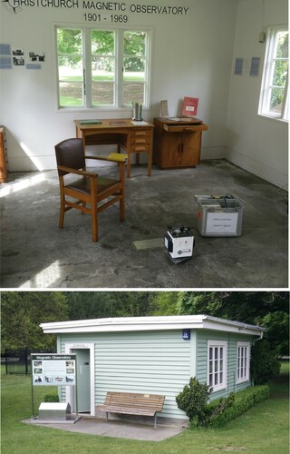
Figure 1. CHRISTCHURCH-A gravity mark (EQTR) is located on the floor (beneath gravity meter in top image) of the historic magnetic observatory workshop in the Christchurch Botanic Gardens (bottom image).
During the 1960s, a comprehensive campaign to tie a worldwide network of observations and determine gravity values by a single least squares adjustment resulted in the International Gravity Standardization Net 1971 (IGSN71) (Morelli et al. Citation1972). At various times during the campaign sites in Auckland, Hastings, Wellington, Christchurch and Dunedin were occupied, including 20 observations at CHRISTCHURCH-A (EQTR). Comparison of the differences between IGSN71 gravity values and pendulum gravity stations in the USA, England, France and Potsdam revealed that a correction of 140 µN/kg to the Potsdam datum was required (Woollard Citation1979). At about the same time additional gravity values at principal gravity stations were determined by measurements with five LaCoste & Romberg relative gravity meters, three of these tied to the Australian Calibration Line (Hunt and Ferry Citation1975; Hatherton Citation1980). Hunt and Ferry (Citation1975) noted that at CHRISTCHURCH-A there was a 152.1 µN/kg difference between the New Zealand Potsdam system (1959) and the IGSN71 value given by Morelli et al. (Citation1972). Conversion to the IGSN71 datum has subsequently been achieved by subtracting 152.1 µN/kg from gravity values in the New Zealand Potsdam system (1959).
In 1980 Ichiro Nakagawa (Kyoto University) and colleagues undertook a survey around the Pacific using up to eight LaCoste & Romberg model G gravity meters (Nakagawa et al. Citation1983). They reoccupied many of the IGSN71 sites and the survey included a series of gravity observations at Christchurch and Auckland. At CHRISTCHURCH-A they confirmed the IGSN71 gravity value, recording a −0.24 µN/kg difference in gravity from the Morelli et al. (Citation1972) value, which is similar to the estimated accuracy of the surveys.
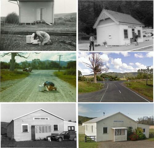
Many of the Primary Gravity Network stations were in railway goods yards or at road intersections () that by the late twentieth century had been demolished or realigned and could not be re-occupied because location diagrams were out of date. In 1977 and 1978 a campaign was undertaken to reoccupy all the remaining Primary Gravity Network stations at least once and about 3 times on average using LaCoste & Romberg relative gravity meter G-106. In some cases, station sites were relocated from the centreline to the edge of roads. Of the original 418 New Zealand Primary Gravity Network stations, 328 were located and reoccupied. Since then, many more sites have been profoundly altered. To some degree the uncertainty of the location of sites has been alleviated by the availability of historic aerial photographs (http://retrolens.nz/) that can be georeferenced in Geographic Information Systems. Using these historic photos many of the Primary Gravity Network stations are now confidently locatable to about 2 m horizontally and location coordinates have been significantly improved. However, there will remain some uncertainty in the site elevation where there has been roadworks and other developments. 75 stations have been destroyed and are not usable. Some sites will require much more traffic management than when they were first established in the 1950s or re-occupied in the 1977 and 1978 resurvey campaign.
Figure 2. Examples of Primary Gravity Network stations. Top left; P. Whitla at Te Wharau (F6CB) in 1978 (photo from C. Whiteford), by 2020 all buildings and the railway line had been removed: top right; Kingston (EQW7) in 1978 can still be located in 2020: middle left; P. Whitla at Rangiahua (EQMV) in 1978 (photo from C. Whiteford) and the site in 2019 at middle right (photo from Google Street View): Bottom left; gravity meter at Ardkeen (EQQR) in 1977 and the site in 2019 at bottom right (photo from Google Street View).
The 2004 revision and addition of gravity at geodetic benchmarks
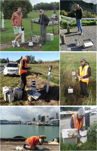
During the late 1970s and early 1980s a campaign of gravity observations on geodetic benchmarks was undertaken around New Zealand with the aim of monitoring secular (long term) gravity changes. All sites were occupied at least three times and about six times on average using LaCoste & Romberg relative gravity meter D-37. The geodetic benchmark survey campaign is the most comprehensive precise-gravity survey ever undertaken in New Zealand, covering most of the country at c. 5 km between stations on benchmarks along the edges of roads with high vertical accuracy (mostly LINZ Order 1 V). As the number of accessible Primary Gravity Network stations have dwindled, these geodetic benchmarks have become the preferred sites for tying gravity surveys using relative gravity meters ().
Figure 3. Examples of GNS Science base stations and geodetic benchmark stations. Top left; V. Stagpoole and R. Blakely (USGS) at mark AC8P in 2014: top right; F. Caratori Tontini at mark AC6D in 2017: middle left; V. Stagpoole with 4 gravity meters at mark AD5A in 2018: middle right; S. Karalliyadda (GNS Science) at mark ABKG in 2018: bottom left; B Davy (GNS Science) at mark F6E0 on Wynyard Wharf, Auckland in 2014: bottom right; Y. Fukuda (Kyoto University) at mark AE3W in 2018.
In 2004, the gravity at geodetic benchmark stations and Primary Gravity Network stations were revised. Observation data from all sites were combined in an internally consistent analysis referenced to the principal gravity stations at Auckland Museum (AUCKLAND-A, F6ED) and University of Otago (Dunedin, EQTT). Excluding stations that were relocated during the 1977–78 resurvey, the mean difference in gravity between the originally published Primary Gravity Network and reprocessed values was c. −0.1 µN/kg with a standard deviation of 1.7 µN/kg. The analysis showed discrepancies up to 10 µN/kg from the originally published Primary Gravity Network, with the largest errors between Primary Gravity Network stations Seddon (EQY6) and Ward (ER0C), and between Idaburn (EQVU) and Omakau (EQXA). In the original network analysis these errors were spread around the circuits and affect the New Zealand provisional and Primary Gravity Network values. The recalculated gravity values, referenced to the New Zealand Potsdam System (1959), were made publicly available via the GNS Science web site from 2004. In recent years more geodetic benchmarks have been tied into the network (Caratori Tontini and Stagpoole Citation2013; Stagpoole and Caratori Tontini Citation2014), forming a comprehensive system of nearly 1500 usable reference gravity stations across New Zealand.
Harbour gravity stations
Davey (Citation1982) and Rose (Citation1992) describe gravity stations established on, or near wharves of major harbours in New Zealand. These stations provide reference gravity at, or close to vessels berths. They have needed to be regularly updated as wharves have become altered, disused or demolished. Between 2011 and 2015 harbour stations were re-established at several North Island ports and at Lyttelton with ties to absolute gravity stations or gravity stations on geodetic benchmarks included in the 2020 revision.
Gravity meter calibration ranges
Relative gravity meters are calibrated at the time of manufacture, but it is desirable to regularly check their accuracy as they age (Reilly Citation1970; Sasagawa et al. Citation1989; Carbone and Rymer Citation1999; Onizawa Citation2019). This is usually achieved by making multiple observations between sites with a precisely known gravity difference to determine a calibration scale factor (β) for the meter (Reilly Citation1970; McCubbine et al. Citation2018; Fukuda et al. Citation2019; Supplementary File 4). In New Zealand several calibration ranges have been established in the Wellington region, Taupō and Christchurch. The difference in gravity between Te Aro and Witako in Wellington (see Supplementary File 2 for locations) is 638.1 ± 0.5 µN/kg (Cowan Citation1960). There is a greater range of 1026.79 ± 0.1 µN/kg between the Avalon Base Absolute station (F6DQ) and geodetic benchmark AC6D near the maximum elevation of State Highway 2 on the Remutaka hill, with 1863.85 ± 0.1 µN/kg available between AC6D and the Tuturumuri Rural Fire and Emergency Absolute station (F6EN) in the Wairarapa. Other calibration ranges have been established on Hawkins Hill south of Wellington city and between pendulum stations at Wellington and Lower Hutt, but these are no longer in use. The Taupō calibration range (446.76 µN/kg ± 0.1 µN/kg) is between TAUPŌ FUNDAMENTAL (2217) and a benchmark west of Taupō (BM 27 in Hunt and Graham Citation2009). The Christchurch calibration range (833.63 ± 0.05 µN/kg) is between absolute gravity stations at the bottom (F6EQ) and the top (F6ER) of the Christchurch Gondola (Bilham et al. Citation2016).
Absolute gravity observations in New Zealand
Absolute gravity observations employing meters that measure the free-fall acceleration of a test body are now regularly made in New Zealand. The most accurate of these meters has a measurement uncertainty of the order of 0.01 µN/kg. The first absolute gravity observation in New Zealand using this type of meter was undertaken from 14 to 20 October 1995 at Godley Head (AABJ), near Christchurch, using a Micro-g Solutions FG-5 gravity meter (No. 102) on transit to McMurdo Station (Sasagawa Citation1996). Since then, absolute gravity observations have continued to be made at Godley Head when suitable gravity meters have been in the country (Rogister et al. Citation2009, Citation2011; Nielson Citation2012; Stagpoole et al. Citation2015; Stagpoole and Dando Citation2015; Bilham et al. Citation2016; Fukuda et al. Citation2019). The Godley Head mark (AABJ) has been occupied more than any other location in New Zealand. Although the site is on conservation land and unlikely to be disturbed, it is not ideal for precise gravity observations because it is located on a high promontory surrounded on three sides by ocean and is affected by ocean surges, high winds and mass loss from erosion of the promontory (Bilham et al. Citation2016).
Absolute gravity has also been observed at other sites in the South Island. In February 2000, Roger Bilham and colleagues observed gravity at 16 sites across the South Island using a Micro-g Solutions FG-5 (No. 111) gravity meter. These sites included CHRISTCHURCH-A (EQTR), Godley Head (AABJ) and Mt John (MTJG). In December 2014 and January 2015, Bilham and colleagues repeated observations at most of the sites across the South Island to compare with the earlier observations and determine the long-term changes in gravity (Bilham et al. Citation2016). The difference in gravity at CHRISTCHURCH-A (at ground level) between IGSN71 (Morelli et al. Citation1972) and Bilham and colleagues in 2000 was +0.55 µN/kg. The change in gravity at the site between 2000 and 2015 was +0.53 µN/kg, mainly due to a change in elevation of −0.11 m during the 22 February 2011 Christchurch earthquake (Bilham et al. Citation2016). lists the gravity observations at CHRISTCHURCH-A since 1947.
Table 1. CHRISTCHURCH-A (EQTR) gravity at mark height (floor level) in µN/kg.
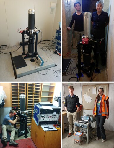
In 2015 absolute gravity observations were undertaken at three South Island and five North Island locations using a Micro-g LaCoste FG-5 gravity meter from AuScope/RSES of the Australian National University (No. 237) and operated by Geoscience Australia (Stagpoole et al. Citation2015). The survey included Godley Head and Mt John absolute gravity sites, the IGSN71 sites in Dunedin (EQTT) and WELLINGTON-A (F6EE) and several new sites in the North Island including a purpose-built mark (WARG) near the Very Long Baseline Interferometry (VLBI) facility of the Warkworth radio astronomy observatory ().
Figure 4. Examples of absolute gravity stations. Top left; Warkworth (WARG) with FG-5 No. 237 in 2015: Top right; absolute gravity meter FG-5 No. 210 at WELLINGTON-A (F6EG) with T. Kazama and Y. Fukuda (Kyoto University) in 2016: bottom left; N. Dando (Geoscience Australia) setting up FG-5 No. 237 at Dunedin (EQTT) in 2015: Bottom right; A. Stronach (Victoria University of Wellington) and J. Black (GNS Science) at right with relative gravity meters being tied to the absolute gravity site at Avalon, Lower Hutt (F6DQ).
Fukuda et al. (Citation2019) document absolute gravity measurements made in 2016 using the Micro-g LaCoste FG-5 (No. 210) gravity meter of Kyoto University, including stations previously occupied by Bilham et al. (Citation2016) in the South Island, WELLINGTON-A (), the Warkworth site and a site at Wairakei (F6EF), near Taupō. The Kyoto University meter returned to New Zealand in subsequent years for observations in Marlborough (McCubbine et al. Citation2020) and Wairarapa. Supplementary File 1 lists all absolute gravity observations made in New Zealand using FG-5 and A-10 gravity meters up to 31 December 2020.
The 2020 revision with ties to absolute gravity stations
By 2020 absolute gravity observations had been made at three IGSN71 stations (Dunedin (F6EH), CHRISTCHURCH-A (EQTR) before and after the 2011 Christchurch earthquake, and WELLINGTON-A (F6EE)). Additionally, from 2015 onward relative gravity meters (primarily LaCoste & Romberg D-37 and G-106) were used to tie from the absolute gravity sites to nearby geodetic benchmarks and a few Primary Gravity Network stations in both North and South islands. In many cases multiple observations were made during separate surveys. The meters were also calibrated using the absolute gravity sites (see Supplementary File 4). These observations are the basis for a project to re-evaluate the gravity reference stations throughout New Zealand, with the whole network, including harbour stations, now tied to absolute gravity stations in the North Island and South Island.
Gravity reprocessing was undertaken using Gsolve software using a Normal Least Squares fit to the data and usually a 99% residual confidence interval (McCubbine et al. Citation2018). A mix of historic (late 1970s and 1980s) and modern observation data were used. Except for CHRISTCHURCH-A (EQTR) where absolute gravity was observed prior to the 2011 Christchurch earthquake, historic observations were reprocessed with ties to sites that have not been affected by deformation from recent earthquakes. For example, reprocessing of late 1970s and early 1980s gravity observations on geodetic benchmarks in the northern South Island did not tie to benchmarks affected by the 2013 Seddon earthquake or the 2016 Kaikōura earthquake. Similarly, geodetic benchmarks close to Wairakei geothermal power station were not used for gravity ties because of ground subsidence in the area (Hunt Citation1970; Hunt Citation1977; Hunt and Graham Citation2009). Historic gravity observations in the Kawerau and Edgecumbe region were made after the 1987 Edgecumbe earthquake. The gravity at geodetic benchmarks around Kaikōura, Ward and Seddon was re-evaluated from surveys undertaken after the 2016 Kaikōura earthquake (McCubbine et al. Citation2020). Gravity at geodetic benchmarks close to Christchurch was also re-evaluated from surveys undertaken after the 2010 Greendale and 2011 Christchurch earthquakes.
Reference gravity at geodetic benchmarks and ports determined from surveys undertaken since 2010 have also been reprocessed with updated gravity ties. These are in Northland, Coromandel, Nelson, Southland and the ports of Auckland, Tauranga, Napier, New Plymouth, Wellington and Christchurch.
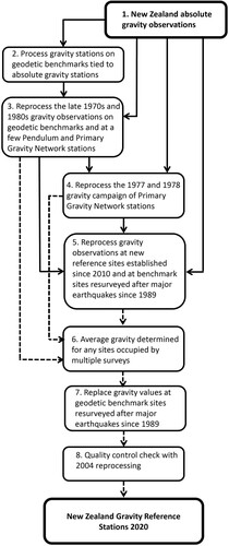
Gravity reprocessing steps are as follows ():
Compile of all absolute gravity observations made in New Zealand (Supplementary File 1).
Process gravity ties from the absolute gravity sites to nearby geodetic benchmarks and Primary Gravity Network stations (Supplementary File 3, Tables S3, S4, S5).
Separately reprocess the late 1970s and 1980s gravity observations on geodetic benchmarks in the South Island (Supplementary File 3, Tables S6, S7) and the North Island (Supplementary File 3, Table S8). North Island observations were tied to WELLINGTON-A (F6EE) plus 11 geodetic benchmarks that were in turn tied to absolute gravity stations at in the Wairarapa, Palmerston North, Tarawera and Warkworth. South Island observations were tied to Dunedin (F6EH), CHRISTCHURCH-A (EQTR) before the 2011 Christchurch earthquake, and 15 geodetic benchmarks that were in turn tied to absolute gravity stations at Dunedin (F6EH), Mount John (MTJG), Christchurch (EQTR), Ward (EXDE) and Seddon (EXDD).
Reprocess the 1977 and 1978 campaign of gravity observations at Primary Gravity Network stations tied to absolute gravity values for Dunedin, CHRISTCHURCH-A (EQTR) before the 2011 Christchurch earthquake, and WELLINGTON-A (F6EG) plus 7 other stations occupied during the geodetic benchmark surveys of 1970s and 1980s (Supplementary File 3, Table S9).
Reprocess gravity observations at new reference sites established since 2010 (mostly geodetic benchmarks) and tied to gravity station values determined in steps 2, 3 and 4 (Supplementary File 3, Tables S10 to S15). These reference sites are in Northland, Coromandel, Nelson, Southland and the ports of Auckland, Tauranga, Napier, New Plymouth, Wellington and Christchurch.
Average gravity determined for any sites reprocessed in both Steps 3, 4 and 5 (80 stations).
Gravity at geodetic benchmarks resurveyed after the 2010 Greendale, 2011 Christchurch, 2013 Seddon and 2016 Kaikōura earthquakes replace values from Steps 3, 4, 5 and 6 (15 gravity sties in total). Gravity ties for the Kaikōura resurvey are listed in Supplementary File 3, Table S16
Quality control; check gravity difference from 2004 revision and earlier processing. New Zealand Gravity Reference Stations 2020 are listed in Supplementary File 2.
Figure 5. Gravity reprocessing steps (numbered) for the New Zealand Gravity Reference Stations 2020. Ties from absolute gravity observations are shown as solid black arrows and the processing sequence linking from reprocessed data through to the final output is shown as dashed arrows.
Differences between gravity reference stations 2020 and earlier gravity networks
The Gravity Reference Stations 2020 is a revision of historical national reference gravity networks; pendulum gravity stations (Cowan and Robertson Citation1964), New Zealand Provisional System (Robertson Citation1960) and the New Zealand Primary Gravity Network (Robertson and Reilly Citation1960). The 2020 revision has 1478 useable stations, all tied to absolute gravity stations within New Zealand, whereas earlier networks relied on ties to international reference gravity stations. With each revision there has been an improvement in accuracy and precision of gravity as reflected in measurements at the CHRISTCHURCH-A (EQTR) reference station ().
The mean difference in gravity between the 2020 revision and the 2004 update referenced to IGSN71 (−152.1 µN/kg) is c. 1.2 ± 0.3 µN/kg in the South Island (). This is in agreement with the difference between absolute gravity measurement in 2000 (Bilham et al. Citation2016) and the 2004 update (−152.1 µN/kg) at CHRISTCHURCH-A (). In the north Island the difference is c. 1.9 ± 0.3 µN/kg. For geodetic benchmarks the standard deviation of 0.3 µN/kg is a good measure of the uncertainty in the gravity value at each station. The uncertainty primarily relates to observation error (meter reading error in the case of non-digital instruments), blunders (incorrect recording of information for data reduction) and instrumental accuracy. Observation errors are reduced and blunders are usually identified with sufficient repeat readings. The Gsolve gravity reduction programme (McCubbine et al. Citation2018) helps to isolate these errors and gravity meter tares (a shift in gravity meter baseline that is not related to meter drift).
Table 2. Average difference in gravity at reference stations between the 2004 and 2020 revisions.
The standard deviation for New Zealand Primary Gravity Network stations (± 0.6 µN/kg) is about twice that of geodetic benchmarks, mostly due to the uncertainty in station location and the fewer number of repeat observations. There are also four Primary Gravity Network stations in the North Island that are more than 4 µN/kg different from the 2004 revision (Makerua (EQRF), Papakauri (EQMC), Puniho (EQMQ), Tongaporutu (EQP5)). The difference relates to the use of alternative absolute gravity ties and the residual confidence criteria used in the data reduction, i.e. the percentage of observations with the highest residuals that are not used in the least-squares gravity recalculation.
Although observations from 330 New Zealand Primary Gravity Network stations are used in the 2020 revision, 76 of the original 418 New Zealand Primary Gravity Network stations can no longer be located or occupied and are deemed to be destroyed or abandoned. In addition, 89 stations were not located and reoccupied in the 1977 and 1978 gravity campaign. Some gravity stations that were occupied in 1977 and 1978 have subsequently been destroyed or abandoned. These two factors in combination result in 127 New Zealand Primary Gravity Network stations that are either destroyed or have not been re-evaluated in the 2020 revision, leaving 292 stations still potentially usable.
Of the 19 original pendulum gravity stations, 13 were reoccupied in the late 1970s and 1980s, eight are deemed destroyed or abandoned and only nine usable stations are in the 2020 revision. Except for CHRISTCHURCH-A (EQTR) and Dunedin (EQTT) where absolute observations have been made, pendulum gravity stations are more of historical interest and it is not recommended that these be used as reference sites for gravity surveys.
In 2020 there are 1123 gravity stations at geodetic benchmarks and 27 base stations established by GNS Science, mainly at wharfs. A further 98 gravity stations at geodetic benchmarks have been destroyed or abandoned since they were first established in the late 1970s and 1980s. However, additional stations, mostly on geodetic benchmarks, are continually being added to the network. Gravity stations at geodetic benchmarks, along with accessible absolute gravity stations form the bulk of the New Zealand Gravity Reference Stations 2020. It is recommended that these gravity stations be used in preference to New Zealand Primary Gravity Network stations because of they have higher accuracy gravity and are often easier to locate.
Changes in gravity with time
Gravity at the reference stations will change over time because of changes in elevation or changes in the density distribution beneath the site. Abrupt and significant changes can occur during earthquakes. For example, the gravity at one geodetic benchmark (AD9F) changed by −5.1 µN/kg in the 2016 Kaikōura earthquake when the height of the station changed by +2.46 m (McCubbine et al. Citation2020). Resurveying of gravity reference stations after these events is essential if stations are to be maintained for reference gravity. The precision of the late 1970s and 1980 surveys is excellent (see Supplementary File 3) and can provide useful information on temporal gravity changes and, in conjunction with accurate positioning at commensurate epochs, can potentially be used for estimating changes in the density distribution related to large earthquakes.
In terms of secular gravity changes, Bilham et al. (Citation2016) and Fukuda et al. (Citation2019) observe changes of 0.1 µN/kg or less per decade. Bilham et al. (Citation2016) noted that excluding sites that had been affected by the 2011 Christchurch earthquake or significant local water level changes, the average change in gravity from 2000 to 2015 for sites in the high-uplift zone of the Southern Alps was −0.06 to −0.1 µN/kg where vertical velocity is up to 5 mm/yr (Tenzer and Fadil Citation2016; Houlié and Stern Citation2017). In areas away from the Southern Alps gravity changes are typically < 0.05 µN/kg per decade. For example, both Bilham et al. (Citation2016) and Fukuda et al. (Citation2019) show a gradual change of c. −0.04 µN/kg per decade at Godley Head, excluding the abrupt change related to the 2011 Christchurch earthquake. In addition, groundwater level variabilities and local topography changes (man-made earthworks or natural landslides) contribute to the difference between repeat gravity observations. These are typically ±0.02 µN/kg, but in some cases gravity changes may amount to as much 0.5 µN/kg (Bilham et al. Citation2016).
Vertical velocities in the North Island have been recorded at continuous and semi-continuous GPS sites (Tenzer and Fadil Citation2016; Houlié and Stern Citation2017) and using interferometric synthetic aperture radar (InSAR) data (Hamling et al. Citation2015). Based on the relationship described in Bilham et al. (Citation2016) for the Southern Alps, subsidence in the Wairarapa region of the East Coast is c. 3–5 mm/yr would contribute to a gravity change of c. 0.05–0.1 µN/kg per decade. The highest vertical velocities, outside geothermal fields, are north of Taupō and range from subsidence of 25 mm/yr to uplift of 10 mm/yr. The resulting change in gravity would be expected to range from c. + 0.45 to −0.18 µN/kg per decade. There are no gravity reference stations at geodetic benchmarks in the areas of high subsidence (> 5 mm/yr) and one station in the area of highest uplift (AFPN). Given the amount of deformation observed in the Taupō Volcanic Zone, any gravity reference stations in the region should be regularly resurveyed.
Within geothermal fields that are being exploited for power production, gravity is changing by up to 5 µN/kg per decade (Hunt Citation1970; Hunt Citation1977; Hunt and Graham Citation2009). For this reason, gravity reference stations have not been sited geothermal fields. Gravity at the Wairakei absolute gravity station (F6EF) is estimated to be changing at c. 0.65 µN/kg per decade and this site should not be used as a gravity reference station without being resurveyed.
Although the 2020 revision of gravity uses observations made in the late 1970s and 1980s it is unlikely that there have been significant changes in gravity at most of these sites. Most gravity reference stations are sited in areas with small changes in secular gravity. Local variations in groundwater level and alteration to nearby topography from erosion and roadworks probably have a larger influence on any changes in gravity at most sites. Gravity reference stations that have been affected by significant height changes during earthquakes have been resurveyed and stations in zones of high uplift in the Southern Alps or subsidence in the Wairarapa are expected to have gravity changes of a similar magnitude to the estimated uncertainty for gravity at each site (± 0.3 µN/kg). In all but a few sites where there have been significant changes in height, the late 1970s and 1980s observations tied to absolute gravity stations provide a good estimate of the gravity today. However, at some stage in the future it will be worthwhile resurveying sites that are in regions experiencing high vertical velocities.
Conclusions
The New Zealand Gravity Reference Stations 2020 includes revised gravity for pendulum gravity stations (Cowan and Robertson Citation1964), New Zealand Primary Gravity Network stations (Robertson and Reilly Citation1960), stations at geodetic benchmarks and base stations established by GNS Science. It represents the most complete compilation of reference gravity stations in New Zealand to date, and unlike previous compilations, is tied to absolute gravity sites throughout the country.
The Gravity Reference Stations 2020 includes data on 1710 sites. 1475 sites are classed as usable, including eight of the original 19 pendulum gravity stations and 292 New Zealand Primary Gravity Network sites (of the original 418), 1150 geodetic benchmarks stations and GNS Science base stations (mainly sited at wharfs) and 22 absolute stations.
The estimated uncertainty in gravity at geodetic benchmarks and GNS Science base stations is ±0.3 µN/kg and at New Zealand Primary Gravity Network stations ±0.6 µN/kg. The uncertainty primarily relates to observation errors and instrumental accuracy. Gravity changes due to long term variations in elevation, local fluctuations in groundwater level and alteration in nearby topography (from erosion and roadworks) will vary from site to site, but in most cases are estimated to less than ±0.3 µN/kg.
It is recommended that the gravity stations at geodetic benchmarks, absolute gravity sites and GNS Science base stations be used in preference to New Zealand Primary Gravity Network stations because of the higher accuracy gravity observations. Pendulum gravity stations are more of historical value and it is not recommended that these be used as reference sites for gravity surveys.
Details of all gravity reference stations are available via the GNS Science dataset catalogue (https://doi.org/10.21420/96Q5-8581) and the E Tūhura – Explore Zealandia web portal (https://data.gns.cri.nz/tez/) and the LINZ geodetic database (https://www.geodesy.linz.govt.nz/gdb/). New sites are regularly added to the database and users should check the GNS Science dataset catalogue for the most up to date information on the gravity reference stations.
Acknowledgements
The New Zealand Gravity Reference Stations 2020 would not be possible without the 1977 and 1978 campaign to resurvey Primary Gravity Network stations and the campaign of precise gravity observations on geodetic benchmarks in the late 1970s and early 1980s. The authors thank all those involved in this far-sighted work, making gravity observations and the archiving data, particularly Ian Reilly, Andrew Carman, Christine Whitford and Pamela Whitla and others from Geophysics Division of DSIR involved in this work. We also thank those people who collected absolute gravity data from New Zealand and made it available. We particularly thank Roger Bilham and colleagues for their efforts in 2000 and 2015, and Nick Dando (Geoscience Australia), Matt Amos and Rachelle Winefield of Land Information New Zealand (LINZ) for help with additional absolute measurements. Roger also provided additional information on absolute gravity observations for this paper. For helping with field observations in Northland, Coromandel, Nelson, Southland the authors thank Richard Blakely (USGS), Jenny Black, Nicolas Dando and Dan Barker. We also thank Bryan Davy for acquiring gravity data at North Island ports. Reprocessing of the data was undertaken with Gsolve software; we acknowledge Jack McCubbine for developing and testing the software, and Grant O’Brien and Adrian Benson for subsequent improvements and tests. We also thank Phil Scadden and Jenny Black for facilitating the uploading of the gravity data to make it available on GNS Science web site. All gravity reference gravity stations are now part of the LINZ geodetic database; we thank Jerry Simonsen for loading and checking these data. The authors thank journal reviewers for providing useful feedback on the manuscript. This project has been funded from GNS Science capability development funds.
Disclosure statement
No potential conflict of interest was reported by the author(s).
Data availability statement
Details of all absolute gravity observations in New Zealand from 1995 to 2019 are openly available in Figshare at https://doi.org/10.6084/m9.figshare.13682989.v2. A listing of gravity reference stations is available via the GNS Science dataset catalogue (https://doi.org/10.21420/96Q5-8581) and the E Tūhura – Explore Zealandia portal for geoscience web maps and information (https://data.gns.cri.nz/tez/). All reference gravity sites are listed in the LINZ geodetic database and can be searched online or using the Geodetic Marks App (https://www.linz.govt.nz/data/geodetic-services/search-for-geodetic-marks). New sites are regularly added to the database and users should also check the GNS Science dataset catalogue for the most up to date information on the gravity reference stations.
References
- Bilham R, Niebauer T, Pearson C, Molnar P. 2016. Changes in absolute gravity 2000–2015, South Island, New Zealand. New Zealand Journal of Geology and Geophysics. 59:176–186. doi:https://doi.org/10.1080/00288306.2015.1108922.
- Caratori Tontini F, Stagpoole V. 2013. Absolute gravity survey marks in Coromandel Peninsula and Northland established in 2013. GNS Science Miscellaneous Series 58. Wellington: GNS Science. 48p.
- Carbone D, Rymer H. 1999. Calibration shifts in a LaCoste-and-romberg gravimeter: comparison with a Scintrex CG-3M. Geophysical Prospecting. 47:73–83. doi:https://doi.org/10.1046/j.1365-2478.1999.00118.x.
- Cowan M. 1960. Scale factors of gravity Meters AG1-96 and W283 and NZ calibration intervals. Geophysics Division Report 31. New Zealand: Department of Scientific and Industrial Research. 9p.
- Cowan M, Robertson EJ. 1964. Principal pendulum and airport gravity stations in New Zealand. New Zealand Journal of Geology and Geophysics. 7:543–553. doi:https://doi.org/10.1080/00288306.1964.10422101.
- Davey FJ. 1982. New Zealand harbour gravity base stations. Geophysics Division Report 186. New Zealand: Department of Scientific and Industrial Research. 17p.
- Fukuda Y, Takiguchi H, Nishijima J, Gulyaev S, Natusch T, Amos M, Stagpoole V, Pearson C. 2019. New Absolute Gravity Measurements in New Zealand. In Vergos GS et al. editors. International Symposium on Gravity, Geoid and Height Systems 2016, International Association of Geodesy Symposia 148:99-101.
- Hamling IJ, Hreinsdóttir S, Fournier H. 2015. The ups and downs of the TVZ: geodetic observations of deformation around the tāupo Volcanic zone. New Zealand. Journal of Geophysical Research: Solid Earth. 120(6):4667–4679. doi:https://doi.org/10.1002/2015JB012125
- Hatherton T. 1980. Geophysics Division 1951-76. Geophysics Division Report No. 161. New Zealand: Department of Scientific and Industrial Research.
- Houlié N, Stern T. 2017. Vertical tectonics at an active continental margin. Earth and Planetary Science Letters. 457:292–301. doi:https://doi.org/10.1016/j.epsl.2016.10.018
- Hunt TM. 1970. Gravity changes at Wairakei geothermal field, New Zealand. Geological Society of America Bulletin. 81(2):529–536. doi:https://doi.org/10.1130/0016-7606(1970)81[529:GCAWGF]2.0.CO;2
- Hunt TM. 1977. Recharge of water in Wairakei geothermal field determined from repeat gravity measurements. New Zealand Journal of Geology and Geophysics. 20(2):303–317. doi:https://doi.org/10.1080/00288306.1977.10420709.
- Hunt TM, Ferry M. 1975. Gravity measurements at principal New Zealand stations, 1973. New Zealand Journal of Geology and Geophysics. 18(5):713–720. doi:https://doi.org/10.1080/00288306.1975.10421570.
- Hunt TM, Graham DJ. 2009. Gravity changes in the Tauhara sector of the Wairakei-Tauhara geothermal field, New Zealand. Geothermics. 38:108–116. doi:https://doi.org/10.1016/j.geothermics.2008.12.003.
- Jackson JE. 1961. The Cambridge pendulum apparatus. Geophysical Journal International. 4:375–388. doi:https://doi.org/10.1111/j.1365-246X.1961.tb06826.x.
- McCubbine J, Caratori Tontini F, Stagpoole V, Smith E, O’Brien G. 2018. Gsolve, a Python computer program with a graphical user interface to transform relative gravity survey measurements to absolute gravity values and gravity anomalies. SoftwareX. 7:129–137. doi:https://doi.org/10.1016/j.softx.2018.04.003.
- McCubbine JC, Stagpoole VM, Caratori Tontini F, Featherstone WE, Garthwaite MC, Brown NJ, Amos MJ, Fukuda Y, Kazama T, Takiguchi H, Nishijima J. 2020. Evaluating temporal stability of the New Zealand quasigeoid following the 2016 Kaikōura earthquake using satellite radar remote sensing. Geophysical Journal International. 220(3):1917–1927. doi:https://doi.org/10.1093/gji/ggz536.
- Morelli C, Gantar C, McConnell RK, Szabo B, Uotila U. 1972. The international gravity Standardization Net 1971 (I.G.S.N.71). Trieste (IT): International Association of Geodesy. 194 p. (Special publication; 4).
- Nakagawa I, Nakai S, Shichi R, Tajima H, Izutuya S, Kono Y, Higashi T, Fujimoto H, Murakami M, Tajima K, Funaki M. 1983. Precise calibration of scale values of LaCoste & Romberg gravimeters and international gravimetric connections along the Circum-Pacific zone (Final report). Final Report on “Precise Calibration of Scale Values of LaCoste & Romberg Gravimeters and Contribution to the Reform of the International Gravity Standardization Net 1971”. Kyoto University. 117p.
- Nielson JE. 2012. New Zealand A10 measurements 2011. Technical note prepared for Land Information New Zealand, February 2012. Land Information New Zealand. 4p.
- Onizawa S. 2019. Apparent calibration shift of the Scintrex CG-5 gravimeter caused by reading-dependent scale factor and instrumental drift. Journal of Geodesy. 93:1335–1345. doi:https://doi.org/10.1007/s00190-019-01247-9.
- Reilly WI. 1970. Adjustment of gravity meter observations. New Zealand Journal of Geology and Geophysics. 73:697–702. doi:https://doi.org/10.1080/00288306.1970.10431341
- Reilly WI. 1972. New Zealand gravity map series. New Zealand Journal of Geology and Geophysics. 15(1):3–15. doi:https://doi.org/10.1080/00288306.1972.10423942.
- Robertson EJ. 1960. New Zealand Provisional gravity system. Geophysics Division Report no. 27. DSIR Wellington. 43p.
- Robertson EI, Garrick RA. 1960. Gravity measurements in New Zealand with the Cambridge pendulum apparatus. New Zealand Journal of Geology and Geophysics. 3:626–642. doi:https://doi.org/10.1080/00288306.1960.10420150.
- Robertson EI, Reilly WI. 1960. The New Zealand Primary gravity Network. New Zealand Journal of Geology and Geophysics. 3:41–68. doi:https://doi.org/10.1080/00288306.1960.10423143.
- Rogister Y, Bernard J-D, Winefield R, Collett D. 2011. Absolute Gravity Observations at Godley Head, New Zealand 5–7 November 2011. Report prepared for Land Information, New Zealand. Land Information New Zealand. 10p.
- Rogister Y, Le Moigne N, Amos M. 2009. Absolute Gravity Observations at Godley Head, New Zealand, 2 - 4 December 2009. Report prepared for Land Information, New Zealand. Land Information New Zealand. 8p.
- Rose KH. 1992. New Zealand harbour gravity base stations. Geophysics Division Technical Report No. 108. Lower Hutt, New Zealand: DSIR Geology and Geophysics.
- Sasagawa GS. 1996. Absolute Gravity observations at Godley Head, New Zealand. Report prepared for Land Information New Zealand. Land Information New Zealand. 19p.
- Sasagawa GS, Zumberge MA, Stevenson JM, Lautzenhiser T, Wirtz J, Ander ME. 1989. The 1987 Southeastern Alaska gravity calibration range: absolute and relative gravity measurements. Journal of Geophysical Research. 94:766–7666. doi:https://doi.org/10.1029/JB094iB06p07661.
- Stagpoole V, Caratori Tontini F. 2014. Absolute gravity survey marks in the northwestern and Southern South Island established in 2014. GNS Science Miscellaneous Series 73. GNS Science, Lower Hutt, New Zealand. 58p.
- Stagpoole V, Dando N. 2015. 2015 repeat gravity gradient observations at Callaghan – Lower Hutt (GCAG), Palmerston North – Massey (MASG) and Wellington A (WELG) to determine absolute gravity and benchmark level. GNS Science Report 2015/64. GNS Science, Lower Hutt, New Zealand. 24p.
- Stagpoole VM, Dando D, Caratori Tontini F, Black J, Amos M. 2015. Absolute Gravity Observations at principal New Zealand stations 2015, GNS Science Report 2015/46. GNS Science, Lower Hutt, New Zealand. 48p.
- Tenzer R, Fadil A. 2016. Tectonic classification of vertical crustal motions – a case study for New Zealand. Contributions to Geophysics and Geodesy. 46(2):91–109. doi:https://doi.org/10.1515/congeo-2016-0007.
- Woollard GP. 1979. The new gravity system—changes in international gravity base values and anomaly values. Geophysics. 44(8):1352. doi:https://doi.org/10.1190/1.1441012.
- Woollard GP, Rose JC. 1960. Final Report on Gravity Program. Reference No. 60-26, Woods Hole Oceanographic Institution.