Abstract
Characterization of the seasonal and inter-annual spatial and temporal variability of rainfall in a changing climate is vital to assess climate-induced changes and suggest adequate future water resources management strategies. Trends in annual, seasonal and maximum 30-day extreme rainfall over Ethiopia are investigated using 0.5° latitude × 0.5° longitude gridded monthly precipitation data. The spatial coherence of annual rainfall among contiguous rainfall grid points is also assessed for possible spatial similarity across the country. The correlation between temporally coinciding North Atlantic Multidecadal Oscillation (AMO) index and annual rainfall variability is examined to understand the underlying coherence. In total 381 precipitation grid points covering the whole of Ethiopia with five decades (1951–2000) of precipitation data are analysed using the Mann-Kendall test and Moran spatial autocorrelation method. Summer (July–September) seasonal and annual rainfall data exhibit significant decreasing trends in northern, northwestern and western parts of the country, whereas a few grid points in eastern areas show increasing annual rainfall trends. Most other parts of the country exhibit statistically insignificant trends. Regions with high annual and seasonal rainfall distribution exhibit high temporal and spatial correlation indices. Finally, the country is sub-divided into four zones based on annual rainfall similarity. The association of the AMO index with annual rainfall is modestly good for northern and northeastern parts of the country; however, it is weak over the southern region.
Editor Z.W. Kundzewicz; Associate editor S. Uhlenbrook
Citation Wagesho, N., Goel, N.K., and Jain, M.K. 2013. Temporal and spatial variability of annual and seasonal rainfall over Ethiopia. Hydrological Sciences Journal, 58 (2), 354–373.
Résumé
La caractérisation de la variabilité saisonnière et interannuelle spatiale et temporelle des précipitations dans un climat changeant est essentielle pour évaluer les modifications induites par le climat et proposer des stratégies adéquates de gestion future des ressources hydriques. Les tendances des séries de pluies annuelles, saisonnières et les maximums sur 30 jours ont été étudiées sur l'Ethiopie à l'aide d'une grille de données de 0,5° × 0 5° degré carré. La cohérence spatiale des précipitations annuelles entre les points de grille de précipitations adjacents a également été évaluée pour apprécier une possible similarité spatiale à travers le pays. La corrélation entre l'indice de l'oscillation multidécennale de l'Atlantique Nord (OMA) et l'indice de la variabilité pluviométrique a été examinée afin de comprendre la cohérence sous–jacente. Un total de 381 points de la grille de précipitation couvrant cinq décennies (1951–2000) on été comptabilisés sur l'ensemble de l'Ethiopie. Les données sur les précipitations ont été analysées en utilisant le test de Mann–Kendall et la méthode d'autocorrélation spatiale de Moran. Les séries de la baisse dans le Nord, le Nord–Ouest et l'Ouest du pays, alors que quelques points de grille dans l'Est montrent des tendances pluviométriques annuelles à la hausse. La plupart des autres régions du pays présentent des tendances statistiquement non significatives. Les régions à forte répartition des précipitations annuelles et saisonnières présentent des indices élevés de corrélation temporelle et spatiale. Enfin, le pays est divisé en quatre zones en fonction de la similitude des précipitations annuelles. L'association de l'indice de l'OMA aux précipitations annuelles dans les parties Nord et Nord–Est du pays est moyennement bonne, mais elle s'affaiblit dans la région Sud.
Citation Wagesho, N., Goel, N.K., and Jain, M.K. 2013. Temporal and spatial variability of annual and seasonal rainfall over Ethiopia. Hydrological Sciences Journal, 58 (2), 1–20.
INTRODUCTION
Impacts of climate variability and change are felt significantly in the agriculture, water supply and hydropower sectors and adversely affect the socio-economy of Ethiopia. The country has been ravaged by persistent drought of varying extent leading to social and economic ramifications. Rainfall anomalies in the form of extreme wet (1962–1966, 1979, 1998/99 and 2006/07) and extreme dry (1971–1973, 1984–1986, 1992 and 2002–2004) years in the country substantially affected the agricultural sector. The accompanying variability in available surface and subsurface water resources is associated with global and regional climatic variability governed by complex land–atmospheric–ocean processes.
In most water resources planning and management systems, time-invariant hydrological processes, where the past is assumed representative of the future is considered. However, such assumption of stationarity is no longer valid due to the natural variability and anthropogenic induced changes in the climate system. A recent study (Milly et al. Citation2008) argues the need to review existing methodologies to account for the non-stationary behaviour of climatic variables. The complex interactions as the land–atmosphere–ocean continuum yields to varied climatic conditions can be approximated and evaluated through climatic variables such as precipitation, temperature and streamflow describing the process. Precipitation, being one among the main constituents of the hydrologic cycle, ultimately affects surface and subsurface water resources. Therefore, investigation of precipitation pattern and possible trends as functions of spatial and temporal scale over the region is necessary and also helps in deriving mitigation measures and evaluating ecosystem resilience towards such variability.
The summer rainfall that accounts for the major part (approx. 65–95%) of total annual rainfall over Ethiopia is governed by the El Niño-Southern Oscillation (ENSO) and further enhanced by local climatic forcing (Korecha and Barnston Citation2007). Main rainy season droughts in Ethiopia are likely associated with warm ENSO episodes (Seleshi and Demarée Citation1995, Tsegay Citation1998, Seleshi and Zanke Citation2004).
The low frequency fluctuation in North Atlantic sea-surface temperature (SST), known as the North Atlantic Multidecadal Oscillation (AMO), was signalled by both warm and cool phases over the last one and half century. This synoptic-scale signal affects the rainfall pattern of the globe causing drought and hurricanes (Enfield et al. Citation2001, Trenberth and Shea Citation2006) of variable magnitude with conspicuous effects in North Atlantic regions. Its impact is also detectable in the northern part of Ethiopia. The drop in Nile River level during the 1970s and early 1980s appears to be related to a multi-year cool phase in the North Atlantic and a southward retreat of the near equatorial trough (Jury Citation2011). Taye and Willems (Citation2012) argue that changes that occur on the Pacific and Atlantic oceans influence extreme rainfall and flow in the upper Blue Nile basin of Ethiopia. The AMO shows strong and significant correlation to rainfall and streamflow during the dry season.
Rainfall trend analysis has been used by climatologists and hydrologists for many years, and is frequently used nowadays to trace the impact of climatic variability and change due to natural and anthropogenic influences across the globe (Parthasarathy and Dhar Citation1975, Partal and Kahya Citation2006, Christensen et al. Citation2007, Trenberth et al. Citation2007, Kampata et al. Citation2008, Ghosh et al. Citation2009). In a highly agrarian community like Ethiopia, where the livelihood of the population and the gross domestic product of the country are almost entirely dependent upon rain-fed agricultural production, analysis of precipitation patterns is of paramount importance to cope with impacts on crop yields, animal breeding, power production and ecosystem management. Thus, the present study aims to investigate for possible spatial and temporal trends in annual and seasonal rainfall variability over the country by applying rigorous statistical analysis. Short-term persistence in annual and seasonal rainfall patterns is also demonstrated in terms of autocorrelation function, and its statistical significance is examined. Finally, the coherence between the AMO and annual rainfall indices over the analysis window is assessed.
STUDY AREA
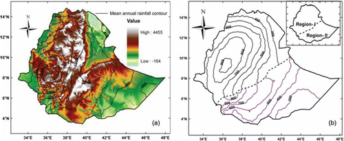
The study area is the whole of Ethiopia, situated between 3° to 15°N latitude and 33° to 48°E longitude, with a total area of 1.13 × 10⁶ km2 (). The region is characterized by highly irregular topography in the central and northern highlands, and the lowland of the rift valley plain that traverses northeast–southwest; elevation ranges from around 110 m below sea level in the Dallol Depression to 4620 m at Ras Dejen in the Simen Mountain massif ((a)). The three major climatic zones of Ethiopia are tropical rainy climate associated with dense forest areas and very high humidity, temperate rainy climate and dry climate. Based on the modified Köppen climate classification of Ethiopia (Gonfa Citation1996, Peel et al. Citation2007), the climatic zones are further subdivided into nine categories to account for average local variability. Monsoon rainfall is highly erratic and unevenly distributed over the country. The monsoon rainy season varies spatially such that the northern part of the country (north and west of the lower rift system) receives most of its rainfall from June to October, but the main monsoon rainy season (“Kiremt” season) is usually from July to September. Relatively low rainfall occurs in the south and southeast of the country with greatest amounts in April and less from then until October. Traditionally, the south/southeast region mainly receives its highest rainfall in the “Belg” (March–May) and in the Kiremt seasons. The spatial distribution of mean annual and seasonal rainfall is depicted in (a) and (b) respectively. Mean annual temperature varies from over 30°C in the lowlands to approximately 10°C at very high altitudes.
Fig. 1 Study area (location map of Ethiopia) and 0.5° × 0.5° spatial resolution monthly precipitation grid of points used for analysis.
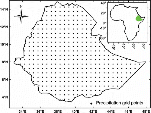
Fig. 2 (a) Mean annual rainfall distribution at 200 mm contour interval overlain on elevation grid map; (b) mean seasonal rainfall pattern where the country is categorized into two regions based on main summer (Region I) and spring/summer (Region II) rainfall distribution.
DATA AND METHODOLOGY
Data used and preliminary data analysis
Data used
Monthly gridded rainfall data at 0.5° × 0.5° resolution for 50 years (1951–2000) covering the entire Ethiopia land area were acquired from the Global Precipitation and Climate Center (GPCC) under the framework of the Variability Analyses of Surface Climate Observations project (http://gpcc.dwd.de). The GPCC provides an updated and globally gridded precipitation estimate extracted from surface raingauge observations with a minimum of 90% data availability over the years 1951–2000. The data set was compiled at several data centres—the Food and Agricultural Organization (FAO) of the United Nations, the Climate Research Unit (CRU) and the Global Historical Climatology Network (GHCN)—and transferred via the Global Telecommunication System (GTS) (Adler et al. Citation2003, Beck et al. Citation2005). Beck et al. (Citation2005) undertook a rigorous interpolation of the precipitation data over the world to 0.5° × 0.5° grid size using ordinary kriging that resulted in the least interpolation error relative to other methods. A total of 381 precipitation grid points () extracted from station data were considered here for further statistical analysis. The number of operational meteorological observatories in Ethiopia in 1999 exceeded 832 (Belete Citation1999) with more monitoring stations being added subsequently. Gridded rainfall data are widely used in various hydro-climatological analyses in different parts of the world (Rajeevan et al. Citation2006, Baigorria et al. Citation2007, Ghosh et al. Citation2009, Mair and Fares Citation2010) and are advocated as suitable for climate variability studies. Jury (Citation2010) used 0.5° × 0.5° gridded precipitation data for the 1901–2007 period from the GPCC data set to study decadal climate variability in Ethiopia. Observed rainfall data for selected stations with sufficient record length were obtained from the National Meteorological Service Agency (NMSA) of Ethiopia to check the validity of gridded data through preliminary data analysis.
Unsmoothed and detrended AMO index data from the Kaplan et al. (Citation1998) Sea Surface Temperature Version 2 (1948–2000) was acquired from the National Oceanic and Atmospheric Administration (NOAA) data set to investigate the AMO–rainfall index relationship. A digital elevation model with 90-m resolution ((a)) was obtained from the Consultative Group on International Agricultural Research – Consortium for Spatial Information (CGIAR-CSI) centre (http://srtm.csi.cgiar.org/) and further analysed to identify the topographical variability of the study area.
Preliminary data analysis
Prior to applying the analytical evaluation, examination of the quality of the available data was conducted to minimize the errors that could propagate throughout the analysis and potentially cause bias in the final decision. Preliminary scrutiny of the observed and gridded rainfall data in terms of time series plots, fitting probability distributions and checking for consistency was done. Both the observed and gridded rainfall series stem from similar distributions. Spatially-close sets of observed and gridded rainfall series have statistically similar mean and standard deviation values.
METHODOLOGY
Spatio-temporal variability of rainfall
Spatial distribution of annual and seasonal rainfall
Climatic variables such as rainfall are highly influenced by local- and synoptic-scale meteorological forcings. Therefore, assessing the spatial variability of time series for observed or extracted values of variables is very demanding. Evaluation of feature similarity based on its location and unique attributes (e.g. mean annual and seasonal rainfall magnitudes) assigned to it simultaneously provides a sound technique to analyse whether there is a spatial relationship (similarity/dissimilarity) in the magnitudes of the variables in space, or not.
The concept of variable similarity in space, generally known as spatial autocorrelation, was developed in the the early 19th century, but the mature conceptual and mathematical description of spatial autocorrelation is credited to Cliff and Ord (Citation1969, Citation1973, Citation1981), and has been applied in many projects (Koenig Citation1999, Ping et al. Citation2004, Cai and Wang Citation2006, Carl and Kuhn Citation2007). The Cliff-Ord model used here is based on Moran's (Citation1950) method in which both the location and its mean annual and seasonal rainfall magnitudes are analysed simultaneously for possible spatial autocorrelation to examine the spatial variability of annual and seasonal rainfall. The method compares the magnitude of a variable at a point to the magnitude at other points with explicit reference to location (Goodchild Citation1986) in the given space domain and evaluates the association strength in terms of an index. Finally, based on the index estimated at a prescribed level of significance, spatial clustering or dispersion of regions is accomplished. Readers are referred to Goodchild (Citation1986) for an explanatory review of spatial analysis.
The Moran (Citation1950) test statistic, I of spatial autocorrelation in a vector of residual û is summarized by Hepple (Citation1991) as:
Under the null hypothesis of no spatial autocorrelation, the statistic I is normally distributed. Cliff and Ord (Citation1969, Citation1973, Citation1981) developed the asymptotic distribution to Moran's test statistic (ZI ) with regression residuals:
The spatial distribution of rainfall influences the volume, peak and time to peak of the runoff hydrograph in a catchment (Singh Citation1997, Chaubey et al. Citation1999, Chaplot et al. Citation2005). The response of spatial variability is more pronounced when runoff is simulated from poorly networked station rainfall data in large catchments (Smith et al. Citation2004). The possible systematic pattern in spatial variability across the compass directions in the study area is demonstrated by estimating the 25, 50, 75 and 100 percentile annual rainfall magnitudes throughout the grid points.
Temporal dependence
The degree to which hydro-meteorological variables at any time ti are dependent upon the value at the preceding time in the domain of the sequence represents the serial correlation, sometimes referred to as autocorrelation. A tendency for a system to remain in the same state from one observation to the next, described as persistence, is associated with positive autocorrelation. Thus, evaluation of the statistical significance of suchdependence in time series (Box and Jenkins Citation1970, Salas et al. Citation1980) prior to development of stochastic models is a trustworthy approach. The significance of the lag-1 serial correlation coefficient for independent and identically distributed series can be computed using methods suggested by Anderson (Citation1942) and later by Kendall and Stuart (Citation1968), and the distribution of rk is approximated as:
Hirsch et al. (Citation1993) defined a test statistic, t, which follows a Student's t distribution with n – 2 degrees of freedom, to assess the significance of the Pearson product moment correlation coefficient as:
The presence of significant serial correlation in hydro-climatic time series affects trend tests (Hamed and Rao Citation1998, Yue et al. Citation2002) and needs to be removed prior to trend analysis. To identify whether or not the lag-1 serial coefficient differs from zero due to sampling error, hypothesis testing for computed r 1 is carried out at a prescribed level of significance. Thus, the significance of the lag-1 serial correlation coefficient was evaluated by Hirsch's approach and subsequently used to pre-whiten annual and seasonal series.
A serial correlation magnitude of lagk, rk , is not significantly different from zero for random sequences; however, a rk value close to unity describes strong time dependence of the observations. The first-order autocorrelation coefficient is especially important because physical systems dependence on past values is likely to be strongest for the most recent past. Lags of higher order are used when the first-order autocorrelation coefficient is not sufficient to describe the serial dependence. A plot of the set of autocorrelation coefficients of various lags, known as a correlogram, is very important in detecting randomness, short-term correlation and stationarity of the sequence over the observation length (Kottegoda Citation1980, McCuen Citation2003). The presence of a secular trend in time series is associated with high serial correlation magnitude in the correlogram for smaller lags and decreases slightly at higher lags. The upper and lower boundary of the correlogram test statistic, β (Anderson Citation1942) for lag-k serial dependence at α level of significance for N observations is given by:
The corresponding normal variate, , is assumed to follow a normal distribution and obtained from a one-sided test hypothesis.
Trend analysis of annual and seasonal rainfall
Changes in trends of observed daily rainfall have been evident over the second half of the 20th century. Substantial change in heavy rainfall amounts since the late 1940s has been observed in Ethiopia (Easterling et al. Citation1999). Many early rainfall variability and trend analyses conducted in Ethiopia rely on either data records of limited length or qualitative inference of changes from limited, preliminary rainfall statistical analysis, but recent rainfall variability studies by Cheung et al. (Citation2008) and Segele and Lamb (Citation2005) are worth mentioning. Segele and Lamb (Citation2005) discussed variability of the timing of onset and cessation of summer rainfall in Ethiopia. Cheung et al. (Citation2008) conducted regression analysis of rainfall to identify possible spatial and temporal variability. To the knowledge of the authors, no rigorous statistical trend analysis has been conducted covering the whole geographical area of the country with sufficient data length to demonstrate time evolution of rainfall. The significance of such variability needs to be verified through further statistical analysis with prescribed levels of acceptance or rejection so that the results are robust. In the present study, rainfall trend analysis is conducted covering the entire country and based on 381 precipitation grid points with 50 years record length.
The distribution of a time series has a significant effect on trend analysis. Thus, application of trend detection methods that do not rely on the sample distribution is advantageous here. It excludes the complication arising in the normality test when the distribution is transitional and deviation from normality is difficult to identify. A plethora of trend detection approaches are used nowadays, but the widely applicable Mann-Kendall (MK) trend test and Theil (Citation1950) and Sen (Citation1968) slope estimator methods are used in the present study. A summary of their statistical background is presented below.
Mann-Kendall test
The Mann-Kendall (Mann Citation1945, Kendall Citation1975) trend test is a rank-based non-parametric test originally developed for non-correlated data. The MK test statistic (S) is computed as:
For independent and identically distributed data with no tied elements (equal values) the expected value, E (S) and the variance, var (S) of the distribution are:
If one or more data points are tied, the sample standard deviation is corrected to account for tied elements:
Kulkarni and von Storch (Citation1995), and later Yue et al. (Citation2002), argued that the presence of significant serial correlation in time series affects trend tests. The modified MK and pre-whitening approaches are techniques commonly adopted to account for the presence of serial correlation in time series and so avoid degrading the power of trend test methods. If r 1 is found significant, then the pre-whitened series is given as:
Table 1 Significance of lag-1 autocorrelation coefficient for annual rainfall series. No of samples tested: 381; record length: 50 years. Percentage of total sample is given in parentheses
STATISTICAL ANALYSIS RESULTS AND DISCUSSIONS
Autocorrelation
Statistical significance tests of annual and seasonal rainfall were conducted to assess short-term time dependence and to examine the influence of autocorrelation on subsequent trend analysis. From Student's t distribution for n – 2 degrees of freedom the corresponding p values at the 5 and 10% significance levels were obtained and compared with the estimated t statistic. For sample size n = 50 with n – 2 degrees of freedom, the 5 and 10% p values are 1.68 and 1.30, respectively. If the t-test value computed in Equationequation (7)(7) is less than the Student's t distribution at the prescribed level of significance, then the lag-1 autocorrelation is not significant and the variation is due to sampling error. A summary of the t-test results for annual and seasonal (July–August for Region I and April–October for Region II) rainfall series is presented in and .
Table 2 Significance of lag-1 autocorrelation coefficient for seasonal rainfall series. No of samples tested: 381; record length: 50 years. Percentage of total sample is given in parentheses
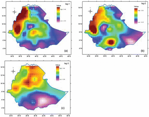
Among the 381 observations, 23% and 22.3% were found significant (5% level) for lag-1 autocorrelation for annual and seasonal series, respectively. The level of serial dependence is similar in both annual and seasonal series. The autocorrelation coefficients of the annual and seasonal series up to lag-n/4 were computed to build a correlogram. The upper and lower confidence intervals of the correlogram were estimated using Anderson's approach (described above). A partial plot of significant positive lag-1 autocorrelation coefficient for annual series is presented in and shows that serial dependence is high for the first two lags and falls asymptotically to zero. A substantial portion of the western and northwestern parts of the country is characterized by high lag-1 and lag-2 coefficients, but the serial interdependence diminishes moving to the eastern and southern regions. The mean annual rainfall series in the latter low serially correlated regions is dominated by independent and identically distributed terms, i.e. the white noise case dominates. A limited portion of the central and southern highlands also experience high lag-1 and lag-2 coefficients ().
Table 3 Moran index and corresponding test statistics for annual and seasonal rainfall series
Fig. 3 Partial plot of correlogram of significant positive lag-1 autocorrelation coefficient for annual rainfall series. The upper and lower boundaries of the correlogram are plotted as dashed lines. Grid coordinates (longitude, latitude) are given on top right corner of each panel.
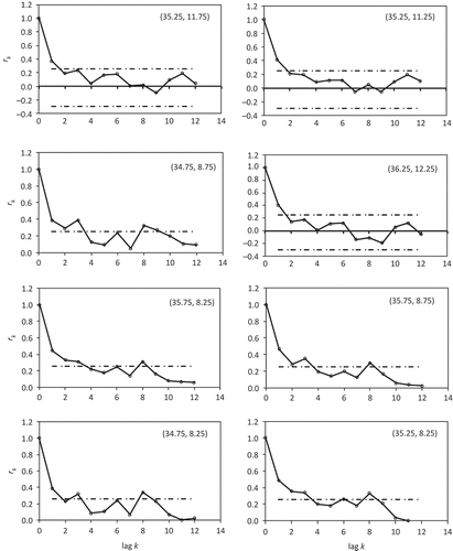
Fig. 4 Time-dependent distribution of annual rainfall series: (a) lag-1 (b) lag-2 and (c) lag-3.
Spatial variability
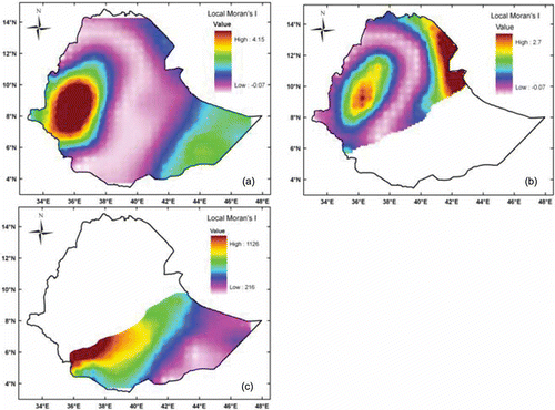
The spatial variability of annual and seasonal rainfall was inspected by applying the spatial similarity (spatial autocorrelation) analysis and percentile rainfall distribution over the region. presents the global and local Moran index for the annual and seasonal rainfall distributions for 1951–2000.
The Z-score statistics show that the spatial pattern of annual and seasonal rainfall is indicative of clustering at the 10, 5 and 1% significance levels. Regions with a high annual and seasonal rainfall variability exhibit high local Moran index values. The annual rainfall is categorized into four distinct zones of spatial association, i.e. either clustering or dispersion ((a)). Zone I (Moran's I: 1.0–4.1) includes the western area reflecting its high annual and seasonal rainfall pattern (Western Oromiya, part of Gambela); the high Moran index values indicate high spatial similarity (clustering) of annual rainfall magnitude. Zone II (I: 1.0–1.2) covers the low altitude northeast (Afar) and a substantial portion of the eastern (Somali) region, and shows moderate spatial similarity. Zone III (I: 0.3–0.9) encompasses a small transition zone from high to low spatial similarity located in the western and eastern parts of the country. Zone IV (I < 1) is a region of statistically insignificant spatial correlation (dispersion) and includes the rift valley floor and adjacent escarpments, and substantial portions of central, northern and southern Ethiopia (Amhara, southern Tigray, SNNPR and Oromiya). The spatial association of mean annual rainfall at one grid point to its contiguous grid points is highly erratic in Zone IV. The seasonal rainfall follows a systematic pattern of spatial correlation in both the northern and southern regions. It increases from the central region towards the northeast and northwest ((b)), and decreases from west to east in the south ((c)).
Fig. 5 Distribution of local Moran index for: (a) annual, (b) summer main rainy season (July–September), and (c) spring/summer season (April–October) rainfall.
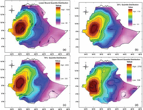
Analysis of long-term multi-grid climatic data covering wide areas is very complex and liable to errors, even given high computing ability. Categorizing the data series into ranges in terms of percentiles to undertake subsequent analysis helps to minimize the potential errors and provides a practical summary. The precipitation magnitude at each grid point for the analysis period was grouped as percentiles (lower, 0.25, 0.5, 0.75 and upper) and examined for spatial variability. The spatial variability of annual precipitation in transects across the country () is shown as box plots. Six combinations of north–south and west–east transects were selected to show the spatial variability of mean annual precipitation over the country. The box plots of mean annual precipitation along the transects are shown in . The trend line fitted to the median values of annual rainfall indicates a falling trend from west-to-east in all transects, while the north–south transects indicate a falling trend in the eastern-most transect. Finally, annual rainfall percentile distribution over the region is mapped with rainfall contours overlaid ().
Fig. 6 North–south and east–west transects considered for annual rainfall spatial variability analysis. The actual longitude and latitude of the transects are shown and PCP denotes precipitation.
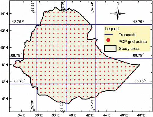
Fig. 7 Box plots of percentile (lower bound, 25, 75 and upper bound) mean annual precipitation along transects of grid points (see Fig. 6). The smooth curve is a trend line fitted to a polynomial.
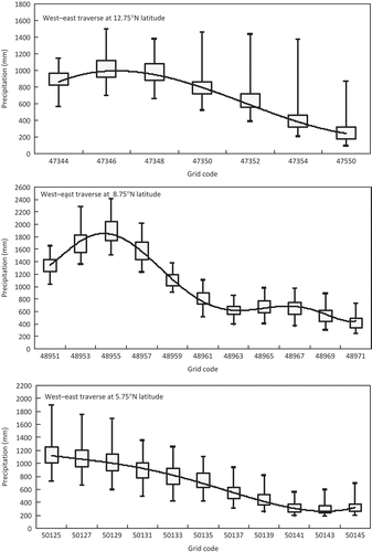
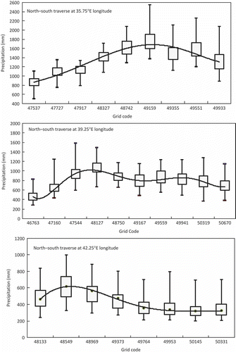
Fig. 8 Spatial distribution of lowest bound, 25, 75 and upper bound percentile of annual rainfall of Ethiopia averaged over the time period 1951–2000.
Trend in rainfall
Annual, seasonal and annual maximum 30-day rainfall trend analysis was carried out by applying the Mann-Kendal trend test to the original and pre-whitened series. MK test statistics (S) and the probability (p) that the null hypothesis could produce a sample as extreme as the observed events by chance, was computed for annual, seasonal and maximum 30-day series and their significance evaluated at the 5 and 10% levels. The total numbers of grid points having a significant increasing or decreasing trend at these significance levels are listed in and their respective geographical distributions are mapped in and . The Sen slope estimator, b, and its minimum and maximum thresholds for the 95% confidence limit were estimated. The total number of significant trends identified by Sen's method was compared to that of the MK test. Almost all samples identified as significant using the MK trend test have the same level of trend strength as in Sen's method. In addition, natural series with significant r 1 were subjected to the MK test after pre-whitening; results are summarized in . Detailed trend test statistics typical of the annual rainfall series are presented in .
Table 4 Total number of grid points with significant trends at 5% and 10% significance level
Table 5 Annual rainfall trend test statistics for significant trends at α = 0.05
A limited portion of the eastern part of Ethiopia shows an increasing annual rainfall trend () over the analysis period based on both the MK original and pre-whitened test methods. Most part of the eastern and northeastern peripheries show a significant decreasing annual rainfall trend. All other parts of the country show no significant trends. The seasonal summer rainfall trend shows decrease () in most parts of northern, northwestern and northeastern Ethiopia. An increasing seasonal rainfall trend is signalled in a limited part of the eastern (Somali and eastern Oromiya) region at 10% significance level for the unfiltered series ((b)).
A noticeable fall in the number of grid points detected as having significant trends (increasing or decreasing) is observed due to pre-whitening. Most precipitation grid points captured as increasing or decreasing trend when the original series are subjected to the MK test fail to show similar trends for pre-whitened series. and show the areas having significant trends using both methods. The percentage area covered by significant annual rainfall trends dropped to 27.3 and 21.7% at the 5 and 10% significance levels, respectively, when pre-whitened series were used for trend analysis. Similar reduction (to 9.1 and 47.2 %, respectively) is evident for seasonal series. It is observed that pre-whitening eliminates some of the actual trend components from the time series and should be applied cautiously in trend detection. This is in agreement with discussions by Hamed (Citation2009), addressing the adverse effects of pre-whitening when true trend exists in the time series. The mutual influence of significant autocorrelation and associated trends in time series is also addressed, with suggested remedial techniques, by Kulkarni and von Storch (Citation1995), Hamed and Rao (Citation1998), Douglas et al. (Citation2000) and Yue et al. (Citation2002).
The study of trends in extreme events is essential to assess the impact of global climate change over regional climatic variability on present and future water resources. Even though interpolation to finer grids could have some influence (such as generating outliers) in the distribution of extreme events over the region, trends in maximum 30-day rainfall events were examined without omitting the outliers. Unlike substantial portions of the northern and western regions of the country, the southeastern regions show an increasing trend in maximum 30-day rainfall. Severe drought years (1983–1984, 1987–1988 and 1990–1992), described as periods having significantly less than the 50-year average annual rainfall due to failure of the main rainy season, were identified from the gridded rainfall data set. The warm ENSO episodes documented in the literature (Pankhurst Citation1966, Degefu 1987, Quinn and Neal Citation1987, Tsegay Citation1998) show rather similar time spans to these drought years; however, the cause–effect relationship between drought years and warm ENSO episodes requires further investigation and is not covered here.
Atlantic Multidecadal Oscillation (AMO) signal and rainfall
Understanding the effect of SST on regional rainfall pattern requires full investigation of the dominant perturbations caused by the global oceans: the AMO, the Indian Ocean modulation and the Pacific Decadal Oscillation (PDO) (Folland et al. Citation1986). In the present context, our investigation is limited to statistical analysis of the AMO and the rainfall index for possible association.
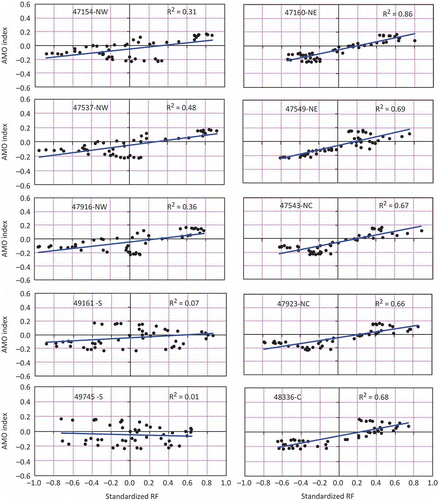
The association of the AMO warm and ensuing cool phases to average annual rainfall was investigated by plotting the AMO index, computed from low-pass filtered area average sea surface temperature over the North Atlantic region (Enfield et al. Citation2001), and the time corresponding standardized annual rainfall for 1951–2000. A 10-year running mean of standardized annual rainfall was superimposed onto the AMO index and the correlation coefficient between AMO and annual rainfall index was examined. It was observed that the annual rainfall pattern in the northern half of Ethiopia (north of 9°25′N) including the Blue Nile basin shows a modestly good correlation (R2: 0.55–0.83) to the AMO index where the warm AMO phases (1951–1965 and 1996–2000) are associated with above average annual rainfall in the region (). However, the correlation is poor (R2: 0.01–1.0) in the southern region (south of 9°25′N). These results are in agreement with previous studies (Segele and Lamb Citation2005, Jury Citation2010, Taye and Willems Citation2012). shows the partial correlation coefficient between AMO and rainfall index over the analysis window. Diverse patterns of fluctuation in wetter and drier years are apparent in the plots of standardized decadal running mean of annual rainfall, i.e. above and below long-term average rainfall oscillates with a period of 10–28 years across the country. An association between the AMO and Ethiopian rainfall cannot be discounted as the north and central part of the country contiguous with the eastern Sahel region show modestly strong AMO–rainfall correlation. However, the association is very weak for rainfall grid points in the southern part of the country. The warm (1951–1965 and 1996–2000) and cool (1966–1995) phases of AMO correlate with the above and below average rainfall index, respectively, in the northern latitudes of the country, but not elsewhere in Ethiopia.
Fig. 11 Low-pass filtered 10-year running mean of standardized annual rainfall (bar charts) superimposed onto AMO index (dashed line). The rainfall grid point code and location is shown in each map (N: north, S: south, NE: northeast, NW: northwest, C: central).
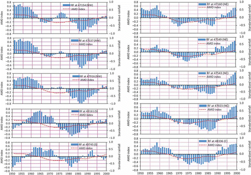
Fig. 12 Correlation coefficient (partial) between standardized annual rainfall and AMO index at specified grid locations (N: north, S: south, NE: northeast, NW: northwest, C: central).
CONCLUSIONS
Characterization of seasonal and inter-annual spatial and temporal variability of rainfall in a changing climate is vital to assess climate-induced changes and suggest adequate water resources management strategies for the future. Trends in seasonal, annual and maximum 30-day extreme rainfall over Ethiopia are investigated. The spatial coherence of annual rainfall among contiguous rainfall grid points was examined for possible spatial similarity across Ethiopia. Furthermore, correlation between time-coincident AMO index and annual rainfall variability was examined to understand the underlying coherence.
For the period 1951–2000, main summer season (July–September) and annual rainfall both exhibit significant decreasing trend in the northern, northwestern and western parts of the country, whereas a small area in the east, bounded by 7°–9°N latitude and 43°–45°E longitude, shows increasing annual and seasonal (April–October) rainfall trends. In most other parts of the country (approx. 77% of the area) the annual rainfall series shows no significant trend during 1951–2000 ( and ). This is in agreement with Mwale et al. (Citation2004) who argue that East Africa suffered a consistent decrease in September–November rainfall from 1962 to 1997 and the climate trend analysis of Kenya (Fact Sheet Citation2010), which suggests increase of summer rainfall to be unlikely for the region from the observed series. Moreda and Bauwens (Citation1998) also observed a declining mean annual and summer rainfall over four consecutive decades since 1951 in the upper Awash basin of Ethiopia. However, the IPCC (Citation2007) Fourth Assessment Report argues that the projected (21st century) mean annual rainfall trend is likely to be increasing in East Africa.
Regions with moderately high to high rainfall (the west and northwest) are characterized by high positive lag-1 and lag-2 serial correlation in rainfall, but the serial dependence diminishes towards the east and south. Based on the Moran spatial analysis, annual rainfall for all the sampling points (381 grid stations) was divided into four zones of annual rainfall spatial autocorrelation. Regions with high annual and seasonal rainfall distribution exhibit high indices of temporal (r 1 and r 2) and spatial (Moran index) autocorrelation. There is a modest correlation between AMO and annual rainfall indices over the last half century in the northern region only. Future studies might focus on global meteorological forcings, such as the ITCZ, El-Niño and La-Niña episodes, in relation to rainfall trends which was beyond the scope of the present investigation.
Acknowledgements
The authors are very grateful to Prof. Z.W. Kundzewicz and Prof. S. Uhlenbrook, co-editor and associate editor of HSJ, respectively, and two anonymous reviewers for their constructive comments on an earlier version that have enriched the contents of the paper. However, the views expressed here are those of the authors alone.
REFERENCES
- Adler , R.F. 2003 . The Version-2 Global Precipitation Climatology Project (GPCP) monthly precipitation analysis (1979–Present) . Journal of Hydrometeorology , 4 : 1147 – 1167 .
- Anderson , R.L. 1942 . Distribution of the serial correlation coefficient . Annals of Mathematical Statistics , 13 : 1 – 13 .
- Anselin , L. 1988 . Spatial econometrics: methods and models , Dordrecht : Kluwer Academic .
- Baigorria , G.A. , Jones , J.W. and O'Brien , J.J. 2007 . Understanding rainfall spatial variability in southeast USA at different timescales . International Journal of Climatology , 27 : 749 – 760 .
- Bayazit , M. and Onoz , B. 2004 . Comment on “Applicability of prewhitening to eliminate the influence of serial correlation on the Mann-Kendall test” by Sheng Yue and Chun Yuan Wang . Water Resources Research , 40 : W08801
- Beck , C. , Grieser , J. and Rudolf , B. 2005 . A new monthly precipitation climatology for the global land areas for the period 1951 to 2000 . Offenbach, Germany: German Weather Service, Climate status report , 2004 : 181 – 190 .
- Belete , A.B. To upgrade the hydrometeorological networks in Ethiopia. In . 25th WEDC conference . Ethiopia. pp. 211 – 214 . Addis Ababa . http://wedc.lboro.ac.uk/knowledge/conference_proceedings.html
- Box , G.E.P. and Jenkins , J.M. 1970 . Time series analysis, forecasting and control , San Francisco, CA : Holden-Day .
- Cai , X. and Wang , D. 2006 . Spatial autocorrelation of topographic index in catchments . Journal of Hydrology , 328 : 581 – 591 .
- Carl , G. and Kuhn , I. 2007 . Analyzing spatial autocorrelation in species distributions using Gaussian and logit models . Ecological Modelling , 207 : 159 – 170 .
- Christensen , J.H. 2007 . “ Regional climate projections ” . In S. Solomon, et al., eds. Climate change 2007: the physical science basis. Contribution of Working Group I to the Fourth Assessment Report of the Intergovernmental Panel on Climate Change , 847 – 940 . Cambridge : Cambridge University Press .
- Cliff , A.D. and Ord , J.K. 1969 . “ The problem of spatial autocorrelation ” . In Studies in regional sciences Edited by: Scott , A.J. Vol. 1 , London: Pion, 25 – 55 .
- Cliff , A.D. and Ord , J.K. 1973 . Spatial autocorrelation , London : Pion .
- Cliff , A.D. and Ord , J.K. 1981 . Spatial processes: models and applications , London : Pion .
- Chaplot , V. , Saleh , V.A. and Jaynes , D.B. 2005 . Effect of the accuracy of spatial rainfall information on the modeling of water, sediment, and NO3-N loads at the watershed level . Journal of Hydrology , 312 : 223 – 234 .
- Chaubey , I. 1999 . Uncertainty in the model parameters due to spatial variability of rainfall . Journal of Hydrology , 220 : 48 – 61 .
- Cheung , W.H. , Senay , G.B. and Singh , A. 2008 . Trends and spatial distribution of annual and seasonal rainfall in Ethiopia . International Journal of Climatology , doi: 10.1002/joc.1623
- Degefu , W. 1987 . “ Some aspects of meteorological drought in Ethiopia ” . In Drought and hunger in Africa—denying famine a future , Edited by: Glantz , M.H. 223 – 226 . Cambridge : Cambridge University Press .
- Douglas , E.M. , Vogel , R.M. and Kroll , C.N. 2000 . Trends in floods and low flows in the United States: impact of spatial correlation . Journal of Hydrology , 240 : 90 – 105 .
- Easterling , D.R. 1999 . Observed variability and trends in extreme climate events: a brief review . Bulletin of the American Meteorological Society , 81 : 417 – 425. .
- Enfield , D.B. , Mestas-Nunez , A.M. and Trimble , P.J. 2001 . The Atlantic Multidecadal Oscillation and its relationship to rainfall and river flows in the continental US . Geophysical Research Letters , 28 : 2077 – 2080 .
- Sheet , Fact . 2010 . A climate trend analysis of Kenya: famine early warning systems network informing climate change adaptation series . USAID-funded FEWS NET project with publishing support provided by the Rolla and Denver Publishing Service Centers, Fact Sheet August – 3074 ,
- Folland , C.K. , Palmer , T.N. and Parker , D.E. 1986 . Sahel rainfall and worldwide sea surface temperature 1901–1985 . Nature , 320 : 602 – 607 .
- Ghosh , S. , Luniya , V. and Gupta , A. 2009 . Trend analysis of Indian summer monsoon rainfall at different spatial scales . Atmospheric Science Letters , 10 : 285 – 290 .
- Gonfa , L. 1996 . Climate classification of Ethiopia , Addis Abeba , , Ethiopia : National Meteorological Service Agency . Meteorological Research Report Series, No. 3
- Goodchild , M.F. 1986 . Spatial autocorrelation: concepts and techniques in modern geography , Norwich , , UK : Geo Books . ISBN 0-86094-223-6
- Hamed , K.H. 2009 . Enhancing the effectiveness of prewhitening in trend analysis of hydrologic data . Journal of Hydrology , 368 : 143 – 155 .
- Hamed , K.H. and Rao , A.R. 1998 . A modified Mann-Kendall trend test for autocorrelated data . Journal of Hydrology , 204 : 182 – 196 .
- Hepple , L.W. 1991 . Testing for spatial autocorrelation in simultaneous equation models . Computers Environment and Urban Systems , 21 ( 5 ) : 307 – 315 .
- Hirsch , R.M. 1993 . “ Statistical analysis of hydrologic data ” . In Handbook of hydrology , Edited by: Maidment , D.R. 17.11 – 17.37 . New York , NY : McGraw-Hill .
- IPCC (Intergovernmental Panel on Climate Change) . 2007 . “ Climate change 2007: the physical science basis ” . In Contribution of Working Group I to the Fourth Assessment Report of the Intergovernmental Panel on Climate Change , Edited by: Solomon , S. Cambridge : Cambridge University Press .
- Jury , M.R. 2010 . Ethiopian decadal climate variability . Theoretical and Applied Climatology , 101 : 29 – 40 .
- Jury , M.R. 2011 . “ Climate factors modulating Nile River flow ” . In Nile river basin: hydrology, climate and water use , Edited by: Melesse , A.M. 267 – 280 . Dordrecht : Springer .
- Kampata , J.M. , Parida , B.P. and Moalafhi , D.B. 2008 . Trend analysis of rainfall in the headstreams of the Zambezi River Basin in Zambia . Physics and Chemistry of the Earth , 33 : 621 – 625 .
- Kaplan , A. 1998 . Analysis of global sea surface temperatures 1856–1991 . Journal of Geophysical Research , 103 : 18,567 – 18,589 .
- Kendall , M.G. 1975 . Rank correlation methods , London : Charles Griffin .
- Kendall , M.G. and Stuart , A. 1968 . The advanced theory of statistics , Vol. 1 , London : Charles Griffin .
- Koenig , W.D. 1999 . Spatial autocorrelation of ecological phenomena . Trends in Ecology and Evolution , 14 ( 1 ) : 22 – 26 .
- Korecha , D. and Barnston , A. 2007 . Predictability of June–September rainfall in Ethiopia . American Meteorological Society , 135 : 625 – 650 .
- Kottegoda , N.T. 1980 . Stochastic water resources technology , New York, NY : John Wiley & Sons .
- Kulkarni , A. and von Storch , H. 1995 . Monte Carlo experiments on the effect of serial correlation on the Mann-Kendall test of trend . Meteorologische Zeitschrift , 4 NF : 82 – 85 .
- Mair , A. and Fares , A. 2010 . Assessing rainfall data homogeneity and estimating missing records in Makaha Valley, O'ahu Hawai'i . Journal of Hydrologic Engineering , 15 ( 1 ) : 101 – 106 .
- Mann , H.B. 1945 . Nonparametric tests against trend . Econometrica , 13 : 245 – 259 .
- McCuen , R.H. 2003 . Modeling hydraulic change: statistical methods , Boca Raton , FL : Lewis .
- Milly , P.C.D. 2008 . Stationarity is dead: whither water management? . Science , 319, 573--574
- Moran , P.A.P. 1950 . Notes on continuous stochastic phenomena . Biometrika , 37 : 17 – 23 .
- Moreda, F. and Bauwens, W., 1998. Influences of variability of rainfall on flow regimes in central Ethiopia. In: E. Servat, et al., eds. Water resources variability in Africa during the XXth century (Proceedings of Abidjan ‘98 Conference). Wallingford, UK: IAHS Press, IAHS Publ. 252, 297–305. Available from[Accessed 5 November 2010]. http://www.iahs.info/redbooks/252.htm (http://www.iahs.info/redbooks/252.htm)
- Mwale , D. , Gan , T.Y. and Shen , S.S.P. 2004 . A new analysis on variability and predictability of seasonal rainfall of central southern Africa . International Journal of Climatology , 24 : 1509 – 1530 .
- Pankhurst , R. 1966 . The great Ethiopian famine of 1888–92 . Journal of History of Medicine and Allied Sciences , 21 : 95 – 124 . 271–294
- Partal , T. and Kahya , E. 2006 . Trend analysis in Turkish precipitation data . Hydrological Processes , 20 : 2011 – 2026 .
- Parthasarathy , B. and Dhar , O.N. 1975 . Trend analysis of annual Indian rainfall . Hydrological Sciences Bulletin , 20 ( 2 ) : 257 – 260 .
- Peel , M.C. , Finlayson , B.L. and McMahon , T.A. 2007 . Updated world map of the Koppen-Geiger climate classification . Hydrology and Earth System Sciences , 11 : 1633 – 1644 .
- Ping , J.L. 2004 . Exploring spatial dependence of cotton yield using global and local autocorrelation statistics . Field Crops Research , 89 : 219 – 236 .
- Quinn , W.H. and Neal , V.T. 1987 . El Niño occurrences over the past four and half centuries . Journal of Physics Research , 92 : 14449 – 14461 .
- Rajeevan , M. 2006 . High resolution daily gridded rainfall data for the Indian region: analysis of break and active monsoon spells . Current Science , 91 ( 3 ) : 296 – 306 .
- Salas , J.D. 1980 . Applied modeling of hydrologic time series , Littleton , CO : Water Resources Publications .
- Segele , Z.T. and Lamb , P.J. 2005 . Characterization and variability of Kiremt rainy season over Ethiopia . Meteorology and Atmospheric Physics , 89 : 153 – 180 .
- Seleshi , Y. and Demarée , G.R. 1995 . Rainfall variability in the Ethiopian and Eritrean highlands and its links with the Southern Oscillation Index . Journal of Biogeography , 22 : 945 – 952 .
- Seleshi , Y. and Zanke , U. 2004 . Recent changes in rainfall and rainy days in Ethiopia . International Journal of Climatology , 24 : 973 – 983 .
- Sen , P.K. 1968 . Estimates of the regression coefficient based on Kendall's tau . Journal of the American Statistical Association , 63 : 1379 – 1389. .
- Singh , V.P. 1997 . Effect of spatial and temporal variability in rainfall and watershed characteristics on stream flow hydrograph . Hydrological Processes , 11 : 1649 – 1669 .
- Smith , M.B. 2004 . Runoff response to spatial variability in precipitation: An analysis of observed data . Journal of Hydrology , 298 : 267 – 286 .
- Taye , M.T. and Willems , P. 2012 . “ Temporal variability of hydroclimatic extremes in the Blue Nile basin ” . In Water Resources Research Vol. 48 , W03513 doi: 10.1029/2011, WR011466
- Theil , H. 1950 . A rank-invariant method of linear and polynomial regression analysis, III . Nederlands Akademie Wetensch. Proceedings , 53 : 1397 – 1412 .
- Trenberth , K.E and Shea , D.J. 2006 . Atlantic hurricanes and natural variability in 2005 . Geophysical Research Letters , 33 : L12704
- Trenberth , K.E. 2007 . “ Observations: surface and atmospheric climate change ” . In S. Solomon, et al., eds. Climate change 2007: The physical science basis. Contribution of Working Group I to the Fourth Assessment Report of the Intergovernmental Panel on Climate Change , 235 – 336 . Cambridge : Cambridge University Press .
- Tsegay, W., 1998. El Niño and drought early warning in Ethiopia. Internet Journal of African Studies, No. 2. Available from[Accessed 28 September 2010]. http://ccb.colorado.edu/ijas/ijasno2/georgis.html (http://ccb.colorado.edu/ijas/ijasno2/georgis.html)
- Yue , S. , Pilon , P. and Cavadias , G. 2002 . Power of the Mann-Kendall and Spearman's rho tests for detecting monotonic trends in hydrological series . Journal of Hydrology , 259 : 254 – 271 .