Abstract
The subject of this article is the tradition of world maps that illustrate Macrobius' Commentary on the Dream of Scipio in manuscripts produced before 1100. Examination of the maps in manuscript context reveals that the primary purpose of the image was to illustrate the direction of ocean flows, the formation of seas, and the relationship of the known world to unknown but hypothesized regions. The image was not static: it was adapted in several different ways—at times simplified, at others made more complex. The evidence of pre‐twelfth‐century manuscripts suggests that it is possible to identify sub‐groups within the corpus of Macrobius maps, but that it may not be possible to establish lines of descent from the original fifth‐century map.
Alfred Hiatt is a lecturer in the School of English, University of Leeds.
La carte de Macrobe avant 1100
Cet article a pour sujet la tradition des cartes du monde qui illustrent le Commentaire du songe de Scipion dans les manuscrits antérieurs à 1100. L'examen des cartes dans leur contexte manuscrit montre que l'objectif initial de l'image était d'illustrer la direction des courants océaniques, la formation des mers et la relation entre le monde connu et les régions inconnues, voire hypothétiques. L'image n'était pas figée: elle était adaptée de différentes manières—dans certains cas simplifiée, dans d'autres rendue plus complexe. Les manuscrits antérieurs au XIIe siècle offrent matière à identifier des sous‐ensembles à l'intérieur du corpus des cartes de Macrobe, mais pas à distinguer des filiations depuis la carte originelle du 5e siècle.
Die Macrobius‐Karte vor 1100
Thema dieses Artikels ist die Tradition der Weltkarten, die Manuskripte von Macrobius Commentarii in Somnium Scipionis aus der Zeit bis 1100 illustrieren. Eine Untersuchung der Karten im Textzusammenhang zeigt, dass der Hauptzweck der bildlichen Darstellung die Verdeutlichung der Richtung von Meeresströmungen, der Gestalt der Ozeane und der Beziehung zwischen der bekannten Welt und unbekannten, aber als existent angenommenen Ländern war. Die Darstellung war nicht statisch: sie wurde auf mehrere unterschiedliche Arten verändert—zu manchen Zeiten vereinfacht, in anderen wieder komplexer ausgeformt. Zusammenfassend kann gesagt werden, dass sich innerhalb des Corpus von Macrobius‐Karten aus der Zeit vor dem 12. Jahrhundert zwar Untergruppen erkennen lassen, Entwicklungslinien vom Original des 5. Jh. jedoch nicht zu identifizieren sind.
El mapa de Macrobius anterior a 1100
Este artículo trata de la tradición de los mapamundis que ilustran los Comentarios del sueño de Escipión, de Macrobius, en manuscritos anteriores a 1100. El examen del mapa en el contexto del manuscrito revela que su propósito principal era ilustrar la dirección de las corrientes del océano, la formación de los mares, y la relación del mundo conocido con unas hipotéticas regiones desconocidas. La imagen no era estática, fue adaptada de varias formas diferentes, algunas veces simplificada y otras veces haciéndola mas compleja. La evidencia de manuscritos anteriores al siglo XII, sugiere la posibilidad de identificar subgrupos dentro del corpus de los mapas de Macrobius, pero no es posible establecer líneas de derivación desde el original del siglo V.
Historians of cartography have long recognized the importance of the world map contained in the early fifth‐century commentary written by Macrobius Ambrosius Theodosius on Cicero's Dream of Scipio. Many classificatory systems advanced for medieval maps in the twentieth century identified Macrobius maps within a particular category, that of the zonal or ‘hemispheric’ map, which represented the northern and southern hemispheres divided into climatic zones, in contrast to maps of the T‐O and other varieties that showed only or primarily the known world.Footnote1 Macrobius maps have nevertheless been studied far less than ecumenical maps, and treatment of them has frequently been cursory. Consequently, while the large number of maps extant in medieval manuscripts of Macrobius' Commentary have often been noted (estimated at around 150, although the precise number is not knownFootnote2), several misapprehensions about these maps persist. The purpose of this article is to provide a clearer picture of the nature—and particularly the function—of the world map in Macrobius' Commentary in the thirty‐five pre‐1100 manuscripts in which it appears.Footnote3 I shall also outline some of the ways in which the map was altered and adapted during the twelfth century.
Context
Before entering into a discussion of the world image in Macrobius' Commentary, it is necessary to explain the literary context in which it appears. The Dream of Scipio (Somnium Scipionis), the final section of Cicero's De re publica, contains the narrative of the cosmic vision accorded to the Roman military tribune and future consul Scipio Aemilianus. Macrobius' commentary on the Dream of Scipio is a philosophical explication of Cicero's text. Motivated by the desire to align Cicero's thought within the framework of late antique Neoplatonism, the Commentary progresses through selected passages of the Dream, amplifying Cicero's words and often digressing from them by means of lengthy expositions of matters only tangentially related to the text. One means used by Macrobius to explain and interpret Cicero's ideas was the deployment of visual images.
The text of the Commentary gives fairly precise instructions for the construction of four diagrams: the Earth (Globus terrae) surrounded by seven planetary spheres within the zodiac (book 1, chapter 21.3–5; Fig. ); an image depicting rainfall on the Earth (designed to demonstrate that weights are drawn to the Earth) (1.22.11–12; Fig. ); the division of the Earth into frigid, temperate and torrid zones (2.5.13–17; Fig. ); and the zonal division of the heavens in relation to the Earth, an image that shows terrestrial zones in an inner circle, surrounded by an outer circle in which the celestial zones are marked (2.7.3–6; Fig. ). The Commentary also implies the presence of a fifth image: the world map (Fig. ). Other diagrams were added by later copyists and commentators on the text; these usually appear as marginal images, whereas the map and other canonical images are typically positioned within the body of the text.Footnote4
Fig. 1. Illustrations for Macrobius' Commentary on the Dream of Scipio. The text was compiled in the fifth century; the manuscript illustrated here dates from the eleventh century. (a) Globus terrae: diagram for Book 1.21.3–5 showing the Earth and seven planetary spheres within the zodiac. (b) Diagram for Book 1.22.11–12, exemplifying the attraction of weights to the earth. British Library, Harley MS 2772, fols. 61v and 63v. Appendix 1, no. 22. (Reproduced with permission from The British Library.)
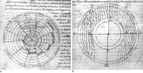
Fig. 2. Further illustrations for Macrobius's Commentary on the Dream of Scipio. (a) Zonal diagram for Book 2.5.13–17, showing the Earth divided into frigid, temperate and torrid zones. The letters that surround the image refer to the text of the Commentary and are intended to allow the reader to understand Macrobius' explanation of zonal theory. (b) Celestial‐terrestrial zonal diagram for Book 2.7.3–6, showing the terrestrial zones within an inner circle surrounded by an outer circle in which the celestial zones are marked. Note how space has been left in the text for the drawings. Cologne, Dombibliothek, MS 186, fols. 106v and 108v. Appendix 1, no. 18. (Reproduced with permission from the Dombibliothek.)
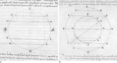
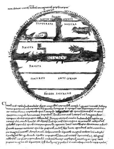
Fig. 3. World map illustrating Macrobius,Commentary on the Dream of Scipio, Book 2.9.7–8, in a tenth‐century manuscript from the abbey of Saint Nazarius at Lorsch, now preserved in Vatican City, the Biblioteca Apostolica Vaticana, MS Palat. lat. 1341, fol. 86v. Appendix 1, no. 4. Compare especially with Figures and . (Reproduced with permission from the Biblioteca Apostolica Vaticana.)
The last three of these images (Figs. –) illustrate the section of Macrobius' Commentary dedicated to the explanation of a passage in the Dream of Scipio in which the dreamer's guide and adoptive grandfather, Scipio ‘Africanus’, describes the habitation of the Earth, its divisions into zones and the comparatively small space occupied by the Roman empire. The dreamer, still bound by earthly cares and impulses, is distracted from the music of the spheres by the sight of the world beneath him. The point of his grandfather's description is to emphasize to Scipio the brevity of human life and worldly achievement (specifically glory and fame), in contrast to the magnitude and permanence of the celestial spheres and the life of the soul. He points out that the Earth is sparsely inhabited, and that those populated places are ‘like spots’ (in ipsis quasi maculis) divided by ‘vast wastelands’ (vastas solitudines). Between the inhabitants of these separated areas nothing can pass, indeed they stand in different parts of the Earth to the Romans: ‘some obliquely, some transversely, some even diametrically opposite to you’ (partim obliquos, partim transversos, partim etiam adversos stare vobis).Footnote5
In this description Cicero adapted theories, usually associated with Crates of Mallos, the Stoic commentator on Homer, that posited four parts of the Earth, only one of which was the known world (oikoumenē), and that assumed the habitation of the three unknown land masses.Footnote6 At this point in the Dream of Scipio, however, the elder Scipio continues his description of the Earth by invoking zonal theory: the Earth is divided by five bands (cinguli), two situated far from each other and ‘stiffened with frost’, the middle one burning with the heat of the sun, the other two habitable:
duo sunt habitabiles, quorum australis ille, in quo qui insistunt, adversa vobis urgent vestigia, nihil ad vestrum genus; hic autem alter subiectus aquiloni, quem incolitis, cerne quam tenui vos parte contingat. omnis enim terra quae colitur a vobis, angustata verticibus, lateribus latior, parva quaedam insula est circumfusa illo mari quod Atlanticum, quod magnum, quem Oceanum appellatis in terris, qui tamen tanto nomine quam sit parvus vides.
[two are habitable: those who dwell in the southern one press their feet against you, and have nothing to do with your people; and this other one lying to the north, which you inhabit—look what a meagre portion has anything to do with you! For all land cultivated by you, narrow at the top and broader at the sides, is a small island surrounded by that sea which you on earth call the Atlantic, the great sea, or Ocean; you see now how small it is despite its great name.]Footnote7
As this passage suggests, in describing the vision of the Earth from the spheres, Cicero infused the Stoic tradition of contempt for the world into standard cosmological discourses.
Macrobius expounded upon the description of the Earth in the Dream of Scipio over the course of five chapters of his Commentary (2.5–9). In large part he explicated the rather compressed cosmological matter in the Dream, identifying the Earth as the ninth and lowest sphere, amplifying its division into frigid, torrid and temperate zones, and explaining the effect of climatic conditions on temperatures in different parts of the world and the nature of the north and south winds. In accounting for the meaning of Cicero's use of the term maculae, and his description of people standing obliquely, transversely and diametrically opposite, Macrobius maintained the probability (based on reason, but not experience) that human habitation was to be found in parts of the world beyond the ecumene and specifically rebutted those who mocked the idea of the antipodes because antipodeans would ‘fall into the sky’ (2.5).
After considering the size of the circumference of the earth (2.6), Macrobius demonstrated the correspondence of terrestrial to celestial zones (2.7), explained the path of the sun between the tropics, and discussed evidence of habitation at the northern tropic (the city of Syene) and south of it in the torrid zone (the city of Meroe) (2.7). The final part of this section is devoted to an explanation of the two oceans—one equinoctial, the other running from pole to pole—that encircle the earth and divide it into four parts, and to a discussion of the flow of water from the eastern and western extremities of the globe to the northern and southern poles (2.9). A concluding remark notes that Cicero emphasized the brevity of the Earth so that the ‘man of honour’ (vir fortis) might perceive the brief duration of fame; however, the focus of this section of the Commentary is scientific rather than moral.
Of particular importance to Macrobius in chapters 2.5–9 was the need to reconcile Cicero's cosmology with the references made by Virgil in Georgics 1.233–51 to celestial zones and the path of the zodiac (2.7). The difference was in part a matter of vocabulary (Virgil used zonae instead of Cicero's cinguli), but it also involved an attempt to smooth over ambiguities caused by Virgil's use of poetic language, such as his apparent description of the path of the sun ‘through’ (per) both the temperate zones, instead of between them (2.8). This concern with the apparent contradictions of Virgilian and Ciceronian tradition draws out the point that Macrobius wished not only to transmit and explicate but also to a significant degree to homogenize classical authority.
The first four diagrams are deeply embedded in the Commentary: instructions for drawing them are provided, as is the explanation of their purpose and meaning. The diagrams are conceived explicitly as pedagogical tools, since, as Macrobius puts it, the fastest way to the intellect is through the eyes: ‘reason sinks into the mind more easily when expressed by drawing than by speech’ (animo facilius inlabitur concepta ratio descriptione quam sermone).Footnote8 Nevertheless the diagram remains within the interpretive framework of the written word. For example, Macrobius begins his instructions for the first zonal diagram:
esto orbis terrae cui adscripta sunt ABCD; et circa A, adscribantur N et L; circa B autem M et K; et circa C, G et I; et circa D, E et F.
[let there be [drawn] a circle of earth on which the letters ABCD are inscribed; and around A, let N and L be written; around B, the letters M and K; and around C, G and I; and around D, E and F] (see Fig. ).Footnote9
He goes on to make clear the meaning of the spaces between the letters, while referring to Cicero's more elliptical description of the frigid zones:
spatia igitur duo adversa sibi, id est unum a C usque ad lineam quae in I ducta est, alterum a D usque ad lineam quae in F ducta est, intellegantur pruina obriguisse perpetua – est enim superior septentrionalis, inferior australis extremitas.
[the two spaces thus opposite each other, that is the one from C up to the line which is drawn from I, the other from D up to the line which is drawn from F, should be understood to be ‘frozen with perpetual winter’, for the upper one is the furthest northern zone, the lower the furthest southern.]Footnote10
Unlike all four previous diagrams Macrobius gives no instructions for the construction of the world map, which he terms a descriptio, a word that could imply visual or verbal representation. Instead he tells the reader that the descriptio will make clear the origins of ‘our sea’ (the Mediterranean), the Red Sea, the Indian Sea and the Caspian Sea, which Macrobius believed to be connected to the Ocean.Footnote11 The descriptio, Macrobius continues, will also illustrate Cicero's statement that our part of the world is ‘narrow at the top and broader at the sides’ (angustam verticibus, lateribus latiorem), and it will reveal what the ancients meant by the remark that our habitable region is shaped ‘like a spread out cloak’ (chlamydi similem).Footnote12 Further, following his reference to the Caspian Sea, Macrobius states that the temperate zone of the southern hemisphere contains a sea comparable to the Mediterranean ‘flowing in from the Ocean’, but that ‘we do not have the evidence for marking this off since its location remains unknown’ (describi hoc nostra attestatione non debuit, cuius situs nobis incognitus perseverat).Footnote13
These comments indicate that Macrobius' text was designed to be accompanied from the first with a visual representation of the known world, featuring major oceans and seas, which also showed the temperate zone of the southern hemisphere. The language used by Macrobius leaves little doubt that by descriptio he meant a visual depiction of these matters:
omnia haec ante oculos locare potest descriptio substituta, ex qua et nostri maris originem, quae totius una est, et Rubri atque Indici ortum videbis, Caspiumque mare unde oriatur invenies.
[all these things can be found before the eyes in the inserted descriptio: from it you will see both the origin of our sea, which is one part of the whole Ocean, and the origins of the Red and the Indian seas; and you will find the source of the Caspian Sea.]Footnote14
It may be concluded from the references in this sentence to the eyes, and to seeing rather than to reading, that the image was to be displayed within the body of the text (that is, not as a marginal illustration or as an appendix) between the sections designated by modern editors as 2.9.7 and 2.9.8. However, in the absence of extant fifth‐century manuscripts of the Commentary, it cannot be unequivocally asserted that the text was illustrated by a map (despite the author's intention that it should be); nor is it certain that, along with the text of the Commentary, the map of Macrobius was transmitted to the Middle Ages by means of an ancient exemplar, rather than reconstructed at a later point.
Unlike the other diagrams that illustrated the Commentary, the lack of explicit instructions meant that the map could not be constructed from Macrobius' text alone. Copyists would always need to consult visual models, such as the maps in other Macrobius manuscripts or in non‐Macrobian texts. This fact would have important implications for the transmission of the world map in the centuries that followed the revival of interest in Macrobius' Commentary in the ninth century.
Reception and Transmission (9th–10th Centuries)
Recent research has made important advances in our knowledge of the reception of Macrobius' Commentary in the medieval period. The work is now thought to have been written around ad 430.Footnote15 It is known to have been copied in Ravenna before 485 by one Aurelius Memmius Symmachus with the assistance of a man who may have been Macrobius' grandson (and therefore, perhaps, with the assistance of Macrobius' own copy of the text).Footnote16
The earliest extant manuscript of Macrobius' Commentary, an eighth‐century manuscript from the monastery of Bobbio, is incomplete. It contains extracts from the Commentary written in Insular script, suggesting that between the late fifth century and the end of the eighth century the text had been copied in the British Isles before being reintroduced to the continent.Footnote17 The earliest surviving complete manuscripts of the Commentary are continental and date from the ninth century; they indicate that a revival of the text occurred in northern France, specifically in the monasteries of Tours, Fleury, Corbie and Auxerre. From these monastic centres the Commentary was transmitted widely. By the tenth century it had reached monastic scriptoria in the Swiss and southern German regions, including St Gall (to which it might have come from Fulda or Reichenau), Echternach, Lorsch, Freising and Regensburg.Footnote18 By the end of the eleventh century, the text could be found throughout western Europe from southern Italy and Spain to England and Wales.Footnote19
Not all extant manuscripts give the complete text of the Commentary. Bruce Barker‐Benfield has identified a sub‐group of manuscripts that contains only an abbreviated version, which lacks the philosophical discussions at the beginning and end of the Commentary, retaining only the central section with most of the cosmological material (1.14.21–2.9.10).Footnote20 The abbreviated version is characteristically supplemented by extracts from Pliny's Natural History. The earliest surviving copy, and possibly the archetype, of this group dates from the second half of the ninth century and was produced in France, possibly at Auxerre (Appendix 1, no. 64).Footnote21 The majority of surviving pre‐twelfth‐century copies of the abbreviated Commentary, however, appear to have been produced in southern Germany. Barker‐Benfield further divides this sub‐group of abbreviated manuscripts into a ‘pure’ family, in which the text of the Commentary remains abbreviated, and another family in which the abbreviated text has been filled out to form a full text of the Commentary.Footnote22
The dissemination of the map of Macrobius was, for obvious reasons, intimately connected with the complex history of transmission of the Commentary. Based on manuscript evidence, one can posit three phases in the development of the world map in Macrobius. The first, ninth‐century, phase can be characterized as a period of uncertainty, in which the map was omitted, sketched or substituted by alternative diagrams. The second phase (tenth and eleventh centuries) saw the solidification of the image in a few key production centres, or nodes, particularly in southern Germany, possibly as a result of the survival and copying of ancient exemplar(s), or owing to scribal reconstruction of the image. The third phase (late eleventh and twelfth centuries) witnessed the beginning of additions to the somewhat spare format of the map: the introduction of an increased quantity of ecumenical representation, and the influence of reworkings of Macrobius' map, especially that by William of Conches.
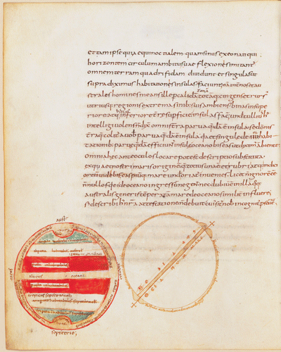
Of the seven manuscripts and fragments of Macrobius' Commentary that can be securely dated to the ninth century, none contains a complete world map. In the six ninth‐century manuscripts that contain the relevant part of the Commentary (2.9.7–8), the map is either lacking or incomplete, or an alternative diagram has been substituted.Footnote23 Two of these ninth‐century manuscripts are particularly revealing of the difficulties posed to scribes and readers by the lack of the map. The earlier of the two was probably initially copied in Tours in the 820s without the four diagrams and the map, but later on in the century it was emended by the renowned scholar Lupus of Ferrières who, according to Barker‐Benfield, supervised the addition of the missing diagrams (Appendix 1, no. 1). Lupus evidently went to considerable trouble to clear space on one page for the insertion of the world map by erasing seventeen lines of text, and rewriting the erased material in a more compressed and heavily abbreviated script (Plate ).Footnote24
However, instead of Macrobius' map, what Lupus had his copyist insert in the space left for it in the text was the drawing of a simple sphere showing the central ocean (Oceanum mare), and the path of the zodiac (Zodiacus), with the tides (Refusiones) marked around the circle. The second drawing on the folio, a zonal diagram to the left of the first, was added by a later, probably twelfth‐century, hand, possibly because the image left by Lupus was deemed unsatisfactory.Footnote25 It can be inferred, then, that Lupus did not have access to a manuscript that contained the map, much as he would have liked one.
A second ninth‐century example reveals a similar pattern of initial omission and later insertion of the world map (Appendix 1, no. 18). In this manuscript, the Commentary, copied in the ninth century, contains the first four canonical diagrams, but at the standard point of insertion of the world map (2.9.7–8, between the words incognitus perseverat and Quod autem), there is a large blank space. In the eleventh century, a copy of Cicero's Dream of Scipio was added to the Commentary.Footnote26 On an otherwise blank page (fol. 74v), between the Dream and the Commentary, we find an aborted map (Fig. ). No toponyms are provided, but several significant features of what I shall suggest was the standard early form of the map have been sketched out: zonal division, the outline of the Mediterranean, the confluence of the Tanais Don River and the Palus Maeotis (that is, Sea of Azov), and the Caspian Sea in the far east.
Fig. 4. An unfinished world map, lacking toponyms, fills an otherwise blank folio in a manuscript of Macrobius' Commentary on the Dream of Scipio. The drawing probably dates from the eleventh century, since it is located between a ninth‐century copy of Macrobius' Commentary and a copy of Cicero's Dream of Scipio added in the eleventh century. Cologne, Dombibliothek MS 186, fol. 74v. Appendix 1, no. 18. (Reproduced with permission from the Dombibliothek.)
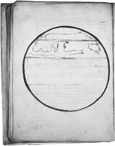
It seems likely that this aborted addition was drawn in the eleventh century, rather than the ninth, partly as a space filler, partly to supplement the Commentary. It is impossible to say why it was not completed. Nor is it possible to say why no map was originally drawn in the correct position within the Commentary (2.9.7–8), where space was left for it. It may be that a copy of the map was not available, or simply that the job of drawing the map was left to an illustrator who did not, in the event, do the work. It seems safe, at any rate, to say that the absence of the map of Macrobius from surviving ninth‐century manuscripts suggests that the exemplars available to the majority of ninth‐century copyists lacked the map.
By contrast, mid tenth‐century and later manuscripts of the Commentary do, in general, contain a map. Given the pattern of dissemination outlined by Barker‐Benfield (summarized above), and confirmed by recent work on the transmission of the Dream of Scipio, it would seem likely that the map was added to the text of the Commentary after it left France, probably in the southern German or Swiss area.Footnote27 At this stage, we can only speculate on the means by which the Commentary reacquired its map, but there are two broad possibilities. The map may have been reconstructed by ninth‐ or tenth‐century scribes, or, alternatively, it may have been copied from an antique exemplar of the Commentary that has not survived.
Study of the toponyms on surviving pre‐twelfth‐century Macrobius maps enables the identification of a standard form of the map, evident in exemplars from the tenth century onwards. The standard form consisted of a relatively schematic representation of the relationship of ocean to land in the northern hemisphere, as well as representation of the five zones, an equatorial ocean and indication of the direction of ocean flows from the equator to the poles. Further, it contained some indication of the Red, Indian and Caspian seas, the last usually represented as an inlet from the outer, encircling Ocean. Only a few other toponyms—usually just Italia and Orcades (the Orkneys)—were marked in the northern hemisphere. Intriguingly, some maps (five of the thirty‐five pre‐1100 exemplars) include the toponyms Syene and Meroe, respectively at the northern tropic and in the torrid zone above the equator.Footnote28 These cities marked the first two of the seven ancient climata, by which the northern hemisphere was divided into horizontal bands. As the locations of these cities are discussed by Macrobius in the surrounding text (2.8.3), their appearance on the map could be an original feature.
In the southern hemisphere, the temperate zone is most frequently marked with some version of the descriptor temperata antecorum (temperate zone of the antoikoi), although on occasion it appears as temperata antipodum (temperate zone of the antipodeans), temperata australis antipodum, or in one exemplar temperata antiktorum (temperate zone of the anticthones, literally those on the opposite side of the earth), and in another temperata antyrtorum (possibly the result of a misreading of antiktorum) (Appendix 2). In eight instances in pre‐1100 manuscripts the temperate southern zone is referred to not in terms of its inhabitants, but simply as ‘temperate’ or ‘habitable’: temperata, temperata zona, temperata australis and habitabilis.Footnote29 In only one manuscript is the entire southern hemisphere left blank (Munich, Bayerische Staatsbibliothek, Clm 6362; Appendix 1, no. 23). In no cases are topographical features marked in the southern temperate zone, in accordance with Macrobius' instruction that, although features similar to those of the known world were likely to exist in the southern hemisphere—for example, another Mediterranean—there was no authority for their representation.
In short, the standard form of the map in this early period would have managed to locate the European reader with great economy in ‘our temperate’ region, using a minimum of toponyms. The image was usually given significance and centrality on the page. It was not marginal, nor was it merely a gloss on the text of Macrobius but an integral part of the text, often attractively coloured and representative of a relatively high level of artistic accomplishment.
This basic form can be seen in a number of tenth‐ and early eleventh‐century examples of the map. In a manuscript copied at the abbey of Saint Nazarius at Lorsch (Appendix 1, no. 4), the world map has been inserted at the standard point in the Commentary, prior to the beginning of section 2.8 (Quod autem). Zones are clearly labelled: Frigida septentrionalis, temperata nostra, perusta (twice), temperata antecorum and frigida australis (Appendix 2). A prominent equatorial ocean (Oceanus) divides the torrid zone. The Red and Indian seas are shown as inlets of the equatorial ocean, while the Caspian Sea is represented in the far east of the ecumene as an inlet of the outer Ocean. Only two other toponyms are marked: Orcades at the far west of the ecumene, and Italia. Although the Mediterranean and the Tanais–Palus Maeotis confluence are prominent features of the map, they are not supplied with toponyms. Ocean flows (refusiones) appear around the map, marking the passage of water from the far west and east of the equatorial ocean to the north and south poles.
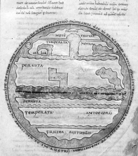
This Lorsch map has clear connections with two other maps produced in the late tenth or early eleventh centuries. The first of these, a map contained in a copy of the Commentary produced in north Italy (now in the Bamberg Staatsbibliothek) (Appendix 1, no. 5), has cruder coastal outlines than the Lorsch map and a disproportionately large northern hemisphere (Fig. ). The Orcades are shown farther north, an equatorial line is marked, there are minor differences in nomenclature (antoecorum instead of antecorum), and the equatorial ocean is not named. Despite these minor differences, the maps in these two manuscripts can be considered different versions of the same state of the map.Footnote30
Fig. 5. World map from a tenth‐ or eleventh‐century north Italian manuscript of Macrobius, Commentary on the Dream of Scipio. North is at the top. The earth is divided into five zones, with the central zone (perusta) unequally divided by the equatorial ocean. Italia and the Orcades are marked, along with the Caspian sea, in the northern temperate zone (temperata nostra). The Red and Indian seas are shown as inlets of the equatorial ocean. The southern temperate zone is marked Temperata antoecorum (temperate zone of the antoikoi). Compare with Figures and . Bamberg, Staatsbibliothek MS Class. 38, fol. 20r. Appendix 1, no. 5. (Reproduced with permission from the Bamberg Staatsbibliothek.)
There are also clear similarities in terms of design, nomenclature and layout between the maps in the Lorsch manuscript and in a roughly contemporary manuscript from south Germany, now in the Bodleian Library, Oxford (D'Orville 77; Appendix 1, no. 16).Footnote31 Like the Lorsch map (), the Bodleian map appears at the top of the page, above a single column of text with the initial Q of Quod coloured and elaborated, although the form of the letter is different (Fig. ). It shares almost identical nomenclature with the Lorsch version (apart from the eccentric antiktorum on the Bodleian map) and has a similar colour scheme. By the same token, the numerous subtle differences in the drawing of the coastlines and the proportions of the ecumene (such as the pronounced T shape of the Tanais–Palus Maeotis confluence on the Bodleian map, and the smaller space allocated to the equatorial ocean on the Lorsch map), indicate that these maps were not directly copied from each other, nor are they likely to have been copied from the same exemplar.
Fig. 6. World map from a south German manuscript of Macrobius,Commentary on the Dream of Scipio, c.1000. Note how space in the text has been left for the drawing. The designation of the southern temperate zone temperata antiktorum is unusual. Compare with Figures and . Oxford, Bodleian Library, MS D'Orville 77, fol. 100r. Appendix 1, no. 16. (Reproduced with permission from the Bodleian Library.)
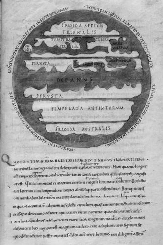
As this discussion of the ‘standard form’ of the map suggests, the process of copying meant that differences of some significance (such as the designation of the temperate southern zone antiktorum instead of antecorum) could occur even between maps that bear an obvious family resemblance.Footnote32 One reason for the lack of uniformity is that scribes did not always copy the map from the exemplar of the Commentary that they were using for the text. The practice of copying maps from exemplars other than those used for the text (perhaps because they contained better versions of the map, or because the exemplar used for the text contained no map) meant that the image was not—as earlier discussions of Macrobius maps have tended to suggest—static, but was subject to near constant modification. That tendency to adapt the image became increasingly apparent in the eleventh and twelfth centuries.
Adaptations and Mutations (11–12th Centuries)
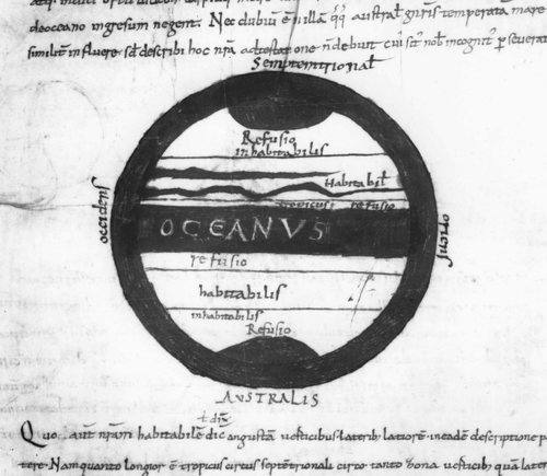
It has been suggested that during the eleventh and twelfth centuries Macrobius' world map developed in two different ways.Footnote33 One was simplification of the image. This mode is particularly evident in the group of manuscripts that contains the abbreviated form of the Commentary. As Barker‐Benfield has pointed out, although these manuscripts include the geographical section of the Commentary and (usually) all five canonical diagrams, the world map does not appear to have been transmitted in any stable form in them.Footnote34 In the earliest surviving exemplar of the abbreviated form of the text (Bern, Burgerbibliothek MS 347, Appendix 1, no. 64), for example, an unfinished circle appears in the position of the map.Footnote35 By the early eleventh century, a version of the map significantly reduced in detail was circulating in a number of manuscripts of this sub‐group, at least five of which survive.Footnote36 The rather spare image of these simplified maps is distinguished by a lack of geographical features in the northern hemisphere, except for two somewhat curious ribbons of water, the northern tropic (marked tropicus), and an indication of habitable (marked habitabilis) zones.
The primary function of this simplified version of Macrobius' world map would seem to have been to show ocean currents (Fig. ). Instead of the usual inscriptions (Refusio oceani ab occidente in septentrionalem, Refusio oceani ab oriente in austrum, etc.), we find simply the word refusio (flow back, return) written in four places: at each pole and above and below the horizontal band of the equatorial Ocean.Footnote37 This state of the map is a simplified version of a more complex model of the world map. The upper ribbon of water would seem to indicate the Mediterranean, while the lower water body could conceivably be a crude approximation of the Nile. A similarly long horizontal body of water appears above the equatorial ocean, dividing Africa from Ethiopia, on at least one other eleventh‐century Macrobius map.Footnote38 It seems probable that, upon finding maps in the early manuscripts of the abbreviated version to be incomplete or absent, a scribe added a simplified version of the map from a manuscript of the complete text.
Fig. 7. This late tenth‐ or eleventh‐century manuscript of Macrobius' Commentary on the Dream of Scipio shows a significantly simplified version of Macrobius' world image. North is at the top. The four cardinal points are marked outside the image. The earth is divided into five zones, with the frigid zones in the far north and south marked uninhabitable (inhabitabilis), the temperate zones in the northern and southern hemispheres marked habitable (habitabilis), and the northern tropic identified by the word tropicus. A prominent equatorial ocean (Oceanus) divides the two hemispheres, and the word refusio is repeated four times to represent the flow of Ocean from the equator to the poles. Munich, Bayerische Staatsbibliothek, Clm 14436, fol. 58r. Appendix 1, no. 9. (Reproduced with permission from the Bayerische Staatsbibliothek.)
The second mode by which the map of Macrobius was adapted in the eleventh and twelfth centuries was the infiltration of ecumenical detail. A striking example is found in the eleventh‐century manuscript mentioned in the previous paragraph, which comes from the south German region and is now in Munich (Bayerische Staatsbibliothek, Clm 6362; Appendix 1, no. 23). Several unusual features of this map are immediately apparent (Fig. ). Zones are indicated by horizontal lines but are not labelled, with the result that the southern hemisphere is blank, in contrast to a detailed ecumene in the north. The southernmost region in the ecumene is marked Ethiopia, as on non‐Macrobian mappaemundi, but it is a most unusual feature on Macrobian maps. Other notable and unusual toponyms on this map include Hierosolima, Roma and Grecia. Other names here, such as Palus meotis, hyperborei (that is, dwellers to the north of Scythia), egyptus, siene ciuitas and meroe, are mentioned by Macrobius in the Commentary, although he does not indicate that they should necessarily be included on the map.
Fig. 8. This eleventh‐century manuscript of Macrobius' Commentary on the Dream of Scipio is unusual for the large amount of ecumenical detail in the northern hemisphere in contrast to the entirely blank southern hemisphere. Features eccentric to the tradition of Macrobius maps include the ideograms that mark certain cities (Rome, Jerusalem, corine [?Corinth], Syene and Meroe), and the attempts to represent the British isles and the Scandinavian peninsula in the far northwest, Sicily (the triangle beneath Italy), and other Mediterranean islands. An unmarked river, presumably the Nile, extends from the Mediterranean, and surrounds Meroe; a second river extends from the Atlantic horizontally, dividing Ethiopia from Africa. Munich, Bayerische Staatsbibliothek Clm 6362, fol. 74r. Appendix 1, no. 23. (Reproduced with permission from the Bayerische Staatsbibliothek.)
![Fig. 8. This eleventh‐century manuscript of Macrobius' Commentary on the Dream of Scipio is unusual for the large amount of ecumenical detail in the northern hemisphere in contrast to the entirely blank southern hemisphere. Features eccentric to the tradition of Macrobius maps include the ideograms that mark certain cities (Rome, Jerusalem, corine [?Corinth], Syene and Meroe), and the attempts to represent the British isles and the Scandinavian peninsula in the far northwest, Sicily (the triangle beneath Italy), and other Mediterranean islands. An unmarked river, presumably the Nile, extends from the Mediterranean, and surrounds Meroe; a second river extends from the Atlantic horizontally, dividing Ethiopia from Africa. Munich, Bayerische Staatsbibliothek Clm 6362, fol. 74r. Appendix 1, no. 23. (Reproduced with permission from the Bayerische Staatsbibliothek.)](/cms/asset/be1f834c-2304-4b6d-95ea-7ba2f3eadb45/rimu_a_229966_o_f0008g.gif)
The relatively detailed topography of the ecumene on Bayerische Staatsbibliothek Clm 6362 includes what appears to be a representation of the British Isles, three Mediterranean islands (with Sicily in its standard triangular shape), and the Caspian, Indian and Red seas. The use of pictorial signs for the cities is another aspect unusual for Macrobian maps. It may be that the city signs and the other features of Clm 6362 were derived from the version of Macrobius' map that had appeared about 1000, along with extracts from the Commentary, in the series of scientific diagrams that conclude the first section of Abbo of Fleury's Computus.Footnote39 The map in Clm 6362 has been given a prominent place on the manuscript page. It is also integral to the text. It may be an overstatement to say that, in wanting to provide an accurate representation of the habitable world the designer ‘subverted the original text’ of Macrobius, but the degree of ecumenical detail it carries does shift the balance of the image towards the topographical and away from the schematic.Footnote40
It is significant that Clm 6362 is a member of the sub‐group of manuscripts in which a copy of the abbreviated Commentary has been filled out to form a full copy of the text.Footnote41 Further evidence for the notion that eccentric states of the map—whether simplified or elaborated—may have a particular association with descendents of the abbreviated form of the Commentary can be found in a Freising manuscript (Munich, Bayerische Staatsbibliothek, Clm 6364; Appendix 1, no. 3), which has been dated to the second half of the tenth century. The Friesing manuscript contains the abbreviated Commentary followed by excerpts from Pliny.Footnote42 Its world map is a curious image, containing only one toponym, caspium mare, yet showing an unusually large northern hemisphere and elaborate pseudo‐coastlines (Fig. ). To the right of the map is a small diagram on which the four cardinal points are marked around the edge, and the northern and southern zones and equatorial Ocean are shown.
Fig. 9. An adaptation of the map of Macrobius contained in a manuscript of the‘abbreviated group’, produced in Freising in the second half of the tenth century. The map is unusual for its single toponym (caspium mare), its particularly large northern hemisphere, and its elaborate pseudo‐coastlines. To the top right of the main figure, the four cardinal points are marked around the edge of of a much smaller diagram, on which the northern and southern zones and equatorial Ocean are also shown. Munich, Bayerische Staatsbibliothek Clm 6364, fol. 23r. Appendix 1, no. 3. (Reproduced with permission from the Bayerische Staatsbibliothek.)
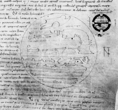
The conjunction of map and diagram in the Freising manuscipt is an unusual and interesting feature. Arguably, the diagram was intended to act as a gloss on the map, drawing attention to the zonal theory and the cardinal points without going into geographical detail. The map is incomplete and in some ways carelessly drawn, but it was plainly intended to feature prominently on the page. The shape given to land in the northern hemisphere is clearly not without meaning and would seem to indicate the existence of a relatively elaborate exemplar.
The Freising manuscript, together with the maps from others in the abbreviated group of manuscripts, suggests that adaptation of the Commentary could have led to discontinuities in the copying of the diagrams, especially the most complex, the world map. In response to the absence of sections of the Commentary, including the map, from their exemplars, scribes were led to improvise a variety of solutions, some of which were in turn copied and disseminated. Those solutions tended either towards the reaffirmation of a simple zonal image and the exclusion of ecumenical detail, or towards the development of the ecumene within the image, resulting in a stark contrast with emptier unknown parts of the world.
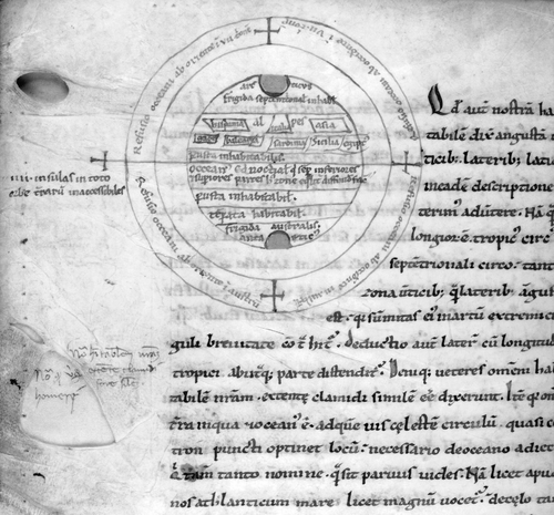
The concentration on the ecumene led to an increase in the amount of geographical information in the northern hemisphere evident in Macrobius maps after 1100. One twelfth‐century form of the map de‐emphasized representation of the seas and added Spain, the Alps, Egypt and Asia to the earlier version's Italia as well as a selection of Mediterranean islands: gades, balearia, sardinia and Sicilia (see Appendix 2; Fig. ).Footnote43 This development appears to have been contemporaneous with, and possibly related to, the innovations made to Macrobius' map by adaptors such as William of Conches.
Fig. 10. This adaptation of Macrobius' world image, which was drawn in the first half of the twelfth century, is notable for the infiltration of ecumenical detail. North is at the top, and the cardinal points are marked with crosses. The toponyms hispania, alpes, gades, balearia, sardinia, Sicilia, egiptus and asia rarely appeared on earlier Macrobius maps. British Library, Egerton MS 2976, fol. 62v . Appendix 1, no. 30. (Reproduced with permission from The British Library.)
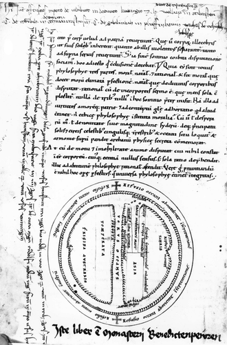
The maps in William's Philosophia and Dragmaticon—texts that date from the second quarter of the twelfth century—kept the zonal division, the equatorial and encircling oceans, and the representation of ocean currents that characterized Macrobius' image.Footnote44 William, however, added the division of the known world into the parts of Europe, Asia and Africa/Libya current in his day. He marked the Mediterranean, as well as the Tanais and the Nile, and indicated the western ends of the known world with the toponyms calpes (one of the fabled columns of Hercules) and athlas, that is, Mount Atlas (Fig. ). To William's innovations copyists could add further detail, such as the Fortunate Islands in the extreme west and the Rhipaean Mountains (mons rifeus, Riphei montes) in the far north. Some of these features were also incorporated on to Macrobius maps: for example, the toponym Gades is found on at least ten twelfth‐century Macrobius maps, but on no exemplar prior to 1100; Atlas appears on at least four twelfth‐century manuscripts but on none prior to that date (see Appendix 2).
Fig. 11. This map, which illustrates a twelfth‐century copy, made in Germany, of Macrobius' Commentary on the Dream of Scipio, shows the influence of maps from William of Conches' Philosophia and Dragmaticon, particularly in the omission of the Indian and Red seas, the division between Europe, Asia, and Africa (Libia), and the appearance of the toponyms athlas, calpe, and fortuna (the Fortunate isles). The diagram has been turned to have west at the top, although the majority of inscriptions are oriented to the north. Note how it occupies space at the end of the text of the Commentary. Below it a later hand has added a note saying that ‘This book is from the monastery of Benediktbeuern’ (Bavaria). Munich, Bayerische Staatsbibliothek, Clm 4612, fol. 103v. Appendix 1, no. 43. (Reproduced with permission from the Bayerische Staatsbibliothek.)
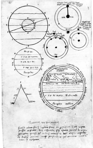
Two other general trends can be noted in Macrobius maps after 1100. The first is towards the reduction in the size of the image. In many tenth‐ and eleventh‐century manuscripts the map was assigned particular prominence and placed centrally on the page, such that it frequently constituted a break in the text, to be followed, for example, by a row of capital letters or a coloured initial. In post‐1100 manuscripts, however, the map tends to occupy less of the page and often to take on a more marginal position. Undoubtedly associated with this trend was the move towards gathering all diagrams together in an appendix (Fig. ). It seems that one strategy in the copying of Macrobian manuscripts from the twelfth century on was to avoid leaving a space in the text of the Commentary at 2.9.7–8, where the map was usually inserted, and to position the map instead, sometimes with the other diagrams, at the end or the beginning of the manuscript. Some copies use scribal marks to enable the reader to match the diagram in the appendix to the relevant part of the Commentary.Footnote45 This separation of the map and other diagrams from the text seems to have been a consequence of the fact that by the thirteenth century the Commentary had become a standard and widely disseminated pedagogic work, with the result that speed of copying became particularly important.
Fig. 12. Munich, Bayerische Staatsbibliothek Clm 18208, fol. 32v. An example of the gathering together of the images in twelfth‐ and thirteenth‐century manuscripts of Macrobius' Commentary into an appendix. On the page reproduced here seven diagrams have been drawn following the explicit of the Commentary. Three are canonical: the celestial and terrestrial zones diagram in the top left corner; the terrestrial zonal diagram beneath it, with zones marked frigida, temperata and torrida; and in the lower right corner the world map. The four non‐canonical images (standard glosses to the text) consist of three diagrams showing the relation of sun and earth to moon at eclipse (top right), and a ‘lambda’ diagram (bottom left, showing multiplication by two and three). On the previous side of the page (32r), immediately following the explicit, three further diagrams appear (two intended to show the ecliptic on either side of the sphere, and a wind diagram). (Reproduced with permission from the Bayerische Staatsbibliothek.)
Maps without a Stemma?
The surviving manuscripts of Macrobius' Commentary indicate that this work was rarely copied solely or primarily for its geographical content, although certainly the text was valued for the geographical information it contained. Sometimes the Commentary was juxtaposed with astronomical extracts from Pliny's Natural History, or placed in proximity to Calcidius' translation of Plato's Timaeus, combinations which indicate its classification as a work of Neoplatonist philosophy and cosmology. On other occasions, the map and parts of the Commentary were integrated with computistical material, which is how it appeared in Abbo of Fleury's collection of computus‐related texts and images as early as the end of the tenth century.Footnote46 But rarely was the Commentary combined with descriptions of the world or travel narratives to form a specifically geographical compendium.
As a consequence, Macrobius' map appeared in the context of scientific diagrams rather than world maps. Despite its geographical content, it was rarely intended to provide an up‐to‐date image of the world. It may be best seen as a bridge between geography and cosmology—between the desire to see and to map the known world and the desire to explain the position of the earth in terms of the cosmic system referred to by Cicero and explicated by Macrobius. By the first half of the twelfth century some authors—such as William of Conches and Lambert of Saint‐Omer, whose Liber Floridus contains perhaps the most elaborate adaptation of Macrobius' map—clearly felt that the map showed an insufficient level of ecumenical detail and set about reworking it.
However much the map was redeployed, though, its primary context remained the Commentary. Almost all indications are that at least until the twelfth century, and for the most part up until the fourteenth and fifteenth centuries, both the world map and the other diagrams were regarded as integral to the Commentary. They might remain incomplete or be omitted altogether, and from the twelfth century they might be repositioned to the beginning or the end of the manuscript to function as appendices. Nevertheless, contrary to Patrick Gautier Dalché's suggestion that the maps and the other diagrams in Macrobius' Commentary played a role ‘fundamentally subordinate to the text’, and that they ‘had all the functions of the gloss’, I would suggest that they were not, on the whole, assimilated to the status of gloss or comment.Footnote47
In my view, a distinction can be made between the map and other diagrams, which were transmitted within the text, and the written and drawn glosses and comments that accumulated around the text of the Commentary. Such a distinction was, I would suggest, commonly made by the copyists themselves when they placed the canonical diagrams within the main body of the text and the additional diagrams and comments in the margins around the text. Certainly the function of the canonical diagrams was explicatory. And certainly the function of canonical diagram and marginal gloss was intended to be complementary, but for both Macrobius himself and his medieval copyists the map seems to have functioned as an alternative to purely verbal description, indeed one that offered a superior mode of understanding. The map was therefore seen as integral to the text.
The integral, stable cartographic tradition constituted by the map of Macrobius nevertheless incorporated significant variety. As such, the tradition of Macrobius maps raises a broad question for the history of cartography: can a map have a stemma? Editors of the text of the Commentary have followed standard practice in reconstructing a stemma, or family tree, of significant early manuscripts, in order to show the relationship between Macrobius' original text and its various manuscript versions.Footnote48 They have undertaken this activity in the hope of determining a version of the text that is as close as possible to the fifth‐century original. In reconstructing this text they have compared readings of several different states of the Commentary, in the belief that no one manuscript is free from scribal error.
One might hope that it would be possible to do the same for the map of Macrobius. We have here an image of the world copied repeatedly as part of the text of the Commentary over at least seven centuries: is it possible to trace lines of descent? Will those lines of descent follow the lines of descent of the written text within which the image was transmitted? The short answer to these questions is no. This study of Macrobius maps suggests the difficulty not only of establishing a stemma from the antique original to its medieval descendents, but also of establishing a stemma even within roughly contemporaneous medieval exemplars.
Of the manuscripts included by the most recent editor of the Commentary in her stemma, only two—Brussels, Bibliothèque royale, MS 10146 (Appendix 1, no. 2) and British Library, Harley MS 2772 (Appendix 1, no. 22)—contain complete world maps (Figs. and ).Footnote49 Neither of these maps provides any particular insight into the original map of Macrobius. Brussels MS 10146, a manuscript of the ninth or tenth century, contains a simple zonal diagram, which may have been added by a later hand. Harley MS 2772 is an eleventh‐century manuscript whose map is directly copied from a tenth‐century south German manuscript which is ‘so heavily corrected that it is difficult to define its original textual affiliations’.Footnote50 So while study of early manuscripts may allow editors to approximate the original text of Macrobius with some degree of accuracy, the same cannot be said for the original map of Macrobius.
Fig. 13. World image illustrating a ninth or tenth century French manuscript of Macrobius,Commentary on the Dream of Scipio. This visually simple map is essentially a zonal diagram with two topographical features (Italia and the Orcades) and the Red, Indian, and Caspian seas sketched in. The unusual position of the Red Sea extending inwards from the far west of the outer ocean, and the thin strip of the zona perusta (usually a prominent feature), supports the impression that this image may be a rather cursory attempt to elaborate a zonal diagram. Brussels, Bibliothèque royale, MS 10146, fol. 109v. Appendix 1, no. 2. (Reproduced with permission of the Bibliothèque royale de Belgique.)
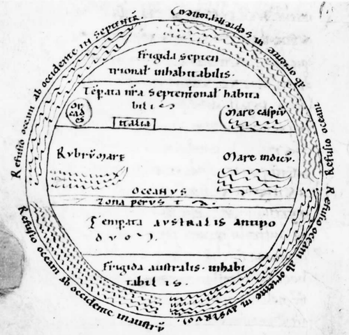
Fig. 14 World map from an eleventh‐century, probably German, manuscript of Macrobius, Commentary on the Dream of Scipio. North is at the top. The map shows the Red and Indian seas emanating from the equatorial ocean and the Caspian sea from the encircling ocean in the northeast. An umbrella‐shaped body of water without toponym (presumably the Tanais joining the Palus Maeotis) is connected to the (unmarked) Mediterranean. The Orcades appear in the far west and Italia is located between the Mediterranean and what may be a representation of the Adriatic. Zonal divisions are marked and (except for the central zone) labelled temperate (temperata) or uninhabitable (inhabitabilis). The temperate southern zone is marked Temperata antetorum: the word antetorum is most likely the result of a misreading of antecorum (i.e. ‘of the antoikoi’, inhabitants beneath the oikoumenē). British Library, Harley MS 2772, fol. 70v. Appendix 1, no. 22. (Reproduced with permission from The British Library.)
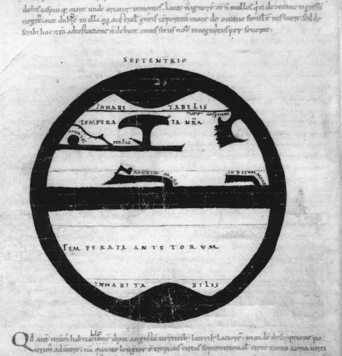
Plate 1. Part of a folio in a ninth‐century manuscript from Macrobius's Commentary on the Dream of Scipio from which seventeen lines of text have been erased and rewritten to make space for the addition of the illustrations. On the right, the renowned late ninth‐century scholar Lupus of Ferrières has inserted the drawing of a simple sphere showing the central ocean (Oceanum mare), and the path of the zodiac (Zodiacus), with the ocean flows (Refusiones) marked around the circle. The zonal diagram to the left of it dates from the twelfth century. Paris, Bibliothèque nationale de France, MS lat. 6370, fol. 89v. Appendix 1, no. 1. (Reproduced with permission from the Bibliothèque nationale de France.) See p. 154.
Investigation of the image in manuscripts dating from before 1100 does indicate that it is possible to identify sub‐groups within the corpus of Macrobius maps, just as the recent editor of Beatus of Liébana's Commentary on the Apocalypse succeeded in identifying sub‐groups of the Beatus mappamundi.Footnote51 Even here, however, it is difficult to establish precise lines of descent within each sub‐group of Macrobius maps. The difficulty lies in the fact that copyists drew on cartographic sources other than Macrobius' Commentary, and they may have copied the text from one manuscript and the diagrams and map from a different manuscript. Nevertheless we can identify some important features of the early versions of Macrobius' map, principally the seas, the ocean flows, and the division of the earth into habitable and uninhabitable regions, as well as known and unknown sections.
We can also affirm that the map of Macrobius was a tradition that evolved, from uncertainty in the ninth century to a standard form in the tenth. It underwent a variety of adaptations in the eleventh and twelfth centuries, in which the image was simplified or augmented according to the requirements of its original fifth‐century author and of the Commentary's subsequent scribes and audiences. The Macrobius maps should be understood as modified zonal diagrams designed to show ocean flows, formation of seas, and the relationship of the known to the unknown world, ecumene to antoecumene. But they also should be seen as subject to interpretation and adaptation according to the interests and resources of the particular people by whom, and the places at which, they were copied.
Acknowledgements
This article is a revised and expanded version of a paper delivered to the 21st International Conference on the History of Cartography, Budapest, in July, 2005. Research on the Macrobius maps was made possible by grants from The British Academy and the Arts and Humanities Research Council, UK. For helpful comments and advice I would like to thank Alexey Postnikov and the two anonymous Imago Mundi readers.
Notes
Alfred Hiatt is a lecturer in the School of English, University of Leeds.
1. In particular, see David Woodward, ‘Medieval mappaemundi’, in The History of Cartography, vol. 1: Cartography in Prehistoric, Ancient, and Medieval Europe and the Mediterranean, ed. J. B. Harley and David Woodward (Chicago, University of Chicago Press, 1987), 286–370, esp. 357, and for earlier formulations Konrad Miller, Mappaemundi: Die ältesten Weltkarten, vol 3: Die kleineren Weltkarten (Stuttgart, Jos. Roth'sche Verlagshandlung, 1895), 122–26; Michael C. Andrews, ‘The study and classification of medieval mappae mundi’, Archaeologia 75 (1924–1925): 61–76; Richard Uhden, ‘Zur Herkunft und Systematik der mittelalterlichen Weltkarten’, Geographische Zeitschrift 37 (1931): 321–40; Marcel Destombes, ed., Mappemondes a.d. 1200–1500 (Amsterdam, N. Israel, 1964), 17. Jörg‐Geerd Arentzen, Imago Mundi Cartographica (Munich, Wilhelm Fink, 1984), 94–96, crucially notes that zonal maps could be combined with T‐O and other ecumenical maps. The rather eccentric pamphlet of Carlos Sanz, El primer mapa del mundo con la representación de los dos hemisferios concebido por Macrobio: Estudio crítico y bibliográfico de su evolución (Madrid, Imprenta Aguirre, 1966), discusses only two Macrobius maps, viewing the geographical theories of Macrobius through the lens of the Age of Discoveries. A useful if brief discussion of the maps in their manuscript context is contained in Alison White, ‘Glosses Composed before the Twelfth Century in Manuscripts of Macrobius' Commentary on Cicero's Somnium Scipionis’, 2 vols. (unpublished D.Phil. thesis, University of Oxford, 1981), 1: 165–68. Evelyn Edson adapts the traditional categories of medieval maps to attain a greater emphasis on content, adding the categories of list map and detailed map: Evelyn Edson, Mapping Time and Space: How Medieval Mapmakers Viewed Their World (London, British Library, 1997), 4–9. The most penetrating discussion of Macrobius maps is contained in Patrick Gautier Dalché, ‘De la glose à la contemplation. Place et fonction de la carte dans les manuscrits du haut Moyen Age’, Settimane di studio del Centro italiano di studi sull'alto medioevo 41 (1994): 693–771, esp. 713–22.
2. Woodward, ‘Medieval mappaemundi’ (see note 1), 300, suggests ‘over 150’; Bruce Barker‐Benfield counts 230 manuscripts of the Commentary from the 9th to the 15th centuries, and 45 prior to 1100 (not all of which contain maps): ‘Macrobius’, in Texts and Transmission: A Survey of the Latin Classics, ed. L. D. Reynolds (Oxford, Clarendon Press, 1983), 222–35, esp. 224; Bruce Eastwood lists 231 Macrobius manuscripts dating from before 1500: ‘Manuscripts of Macrobius, Commentarii in Somnium Scipionis, before 1500’, Manuscripta 38 (1994): 138–55. There is no definitive catalogue of the maps in Macrobius manuscripts. The list in Destombes, Mappemondes a.d. 1200–1500 (see note 1), 43–45, 88–95, is incomplete, and frequently inaccurate, and should be supplemented for Bibliothèque Nationale de France manuscripts by Patrick Gautier Dalché, ‘Mappae mundi antérieures au XIIIe siècle dans les manuscrits latins de la Bibliothèque nationale de France’, Scriptorium 52 (1998): 102–62, and in general by the descriptions and reproductions of Macrobius, and Macrobius‐derived, maps provided in Leonid S. Chekin, Northern Eurasia in Medieval Cartography: Inventory, Text, Translation, and Commentary (Turnhout, Brepols, 2006), 95–120. An impressively large number of the early Macrobius maps (including some no longer extant) were reproduced in Youssouf Kamal, Monumenta Cartographica Africae et Aegypti, 5 vols (Cairo, 1926–1951).
3. See Appendix 1. This figure includes those manuscripts that contain incomplete or abortive attempts to draw the map (App. 1, nos. 64–69) and the map in Metz, Bibliothèque municipale, MS 271, fol. 40v, now destroyed (no. 15); it does not include versions of the map that illustrate brief extracts from the Commentary, such as that contained in Abbo of Fleury's collection, Berlin, Deutsche Staatsbibliothek, MS Phillipps 1833 (Rose 138), fol. 39v. The dating of manuscripts is not secure in all cases.
4. See Michel Huglo, ‘La réception de Calcidius et des Commentarii de Macrobe à l'époque carolingienne’, Scriptorium 44 (1990): 3–20.
5. Cicero, De re publica, ed. K. Ziegler (Leipzig, Teubner, 1964), 6.20. All translations are mine.
6. The primary source for the cosmology of Crates is Strabo, Geography, transl. H. L. Jones (Cambridge, Mass., Harvard University Press, 1917), 1.2.24. A number of different terms existed in ancient geography to describe the peoples of the three unknown land masses. The most common in classical scientific writings were antoikoi (those in the southern hemisphere, on the same longitude as the oikoumenē), perioikoi (those in the northern hemisphere, literally ‘around’ from or on the underside of the oikoumenē), antipodes (those in the southern hemisphere, on the same longitude as the perioikoi), and antikthones (literally those on the opposite side of the earth to the known world, a term that could be used in place of antipodes). See Geminos, Introduction aux phénomènes, ed. Germaine Aujac (Paris, Les Belles Lettres, 1975), 16.1.
7. Cicero, De re publica (see note 5), 6.21.
8. Macrobius Ambrosius Theodosius, Commentarii in Somnium Scipionis, ed. J. Willis (Leipzig, Teubner, 1970), 2.5.13. Compare the introduction of the first diagram: Commentarii, 1.21.3: quia facilior ad intellectum per oculos uia est, id quod sermo descripsit uisus adsignet. All further references are to this edition unless otherwise stated.
9. Ibid., 2.5.13.
10. Ibid., 2.5.14.
11. Ibid., 2.9.7.
12. Ibid., 2.9.8. The term chlamys refers to a type of Macedonian coat.
13. Macrobius, Commentarii (see note 8), 2.9.7.
14. Ibid.
15. Alan Cameron, ‘The date and identity of Macrobius’, Journal of Roman Studies 56 (1966): 25–38, argued that Macrobius' Saturnalia was written in the years immediately after 431; this constituted a revision of earlier scholarship, which, based on references to a Macrobius in the Theodosian Code, had variously dated Macrobius' Commentary c.390–410, and which had tended to suggest dates in the last decade of the fourth century for the Saturnalia. For a brief summary of recent arguments about the date of the Commentary, see Macrobius, Commentaire au Songe de Scipion, ed. Mireille Armisen‐Marchetti, 2 vols. (Paris, Les Belles Lettres, 2001–2003), 1: xvi–xviii.
16. The evidence is contained in the so‐called Symmachus subscription found in nine manuscripts of Macrobius' Commentary; this records that Symmachus, probably the consul of 485 and father‐in‐law of Boethius, corrected (emendabam uel distinguebam—the scope of these terms is uncertain), his copy of the commentary at Ravenna ‘with Macrobius Plotinus Eudoxius’.
17. Barker‐Benfield, ‘Macrobius’ (see note 2), 225. The manuscript, Naples, Biblioteca Nazionale, MS lat. 2, does not contain a world map.
18. Barker‐Benfield, ‘Macrobius’ (see note 2), 225–30; Roberta Caldini Montanari, Tradizione medievale ed edizione critica del Somnium Scipionis (Florence, Edizioni del Galluzzo, 2002), 396–426. See also Alison M. Peden, ‘Echternach as a cultural entrepôt: the case of Macrobius’, in Willibrord: Apostel der Niederlande, Gründer der Abtei Echternach (Luxembourg, Editions Saint‐Paul, 1989), 166–70.
19. Barker‐Benfield, ‘Macrobius’ (see note 2), 230. For a survey of the medieval reception of the Commentary, see Albrecht Hüttig, Macrobius im Mittelalter: Ein Beitrag zur Rezeptionsgeschichte der Commentarii in Somnium Scipionis (Frankfurt am Main, Peter Lang, 1990).
20. Barker‐Benfield, ‘Macrobius’ (see note 2), 227–28. Ludwig Jan identified the abbreviated form of the text in the nineteenth century, as Barker‐Benfield acknowledges (227): Macrobii Ambrosii Theodosii Opera quae supersunt, ed. L. Jan, 2 vols. (Quedlingburg, 1848–1852), 1: lxiv–lxvi, lxxix.
21. Now Bern, Burgerbibliothek, MS 347. Barker‐Benfield, ‘Macrobius’ (see note 2), 227.
22. Barker‐Benfield, ‘Macrobius’ (see note 2), 229–30. He also identifies a third category of manuscripts, which contain ‘those parts of the text not contained in the abbreviated form, and so must have been written to accompany manuscripts of that form’ (230, his italics).
23. The six manuscripts are Bibliothèque nationale de France, MS lat. 6370 (Appendix 1, no. 1); Cologne, Dombibliothek, MS 186 (no. 18); Bern, Burgerbibliothek, MS 347 (no. 64); Bibliothèque nationale de France, MS nal. 454 (no. 68); Biblioteca Apostolica Vaticana, Reg. lat. 1669 (fol. 1v–2); Biblioteca Apostolica Vaticana, Reg. lat. 1762 (fol. 156r–213v). See the comments of Armisen‐Marchetti on the diagrams and maps in the manuscripts used in her edition: Commentaire au Songe de Scipion (note 15), 1: 134, 196; 2: 124–25, 137, 147–48.
24. See the detailed analysis by Bruce Barker‐Benfield, ‘The Manuscripts of Macrobius' Commentary on the Somnium Scipionis’, 2 vols (unpublished D.Phil. thesis, University of Oxford, 1975–1976), 2: 160–201, esp. 170.
25. Compare Gautier Dalché, ‘Mappae mundi antérieures au XIIIe siècle dans les manuscrits latins de la Bibliothèque Nationale de France’ (see note 2) 120–21 and Gautier Dalché, ‘De la glose à la contemplation’ (see note 1), 714–15.
26. Irmgardt Jeffré, ‘Dom MS 186’, in Glaube und Wissen im Mittelalter (Munich, Hirmer Verlag, 1998), 299–302.
27. Roberta Caldini Montanari's research on the transmission of the Dream of Scipio, a text that was frequently disseminated with Macrobius' Commentary, has established a pattern of transmission of the Dream from France to the southern German, Swiss and northern Italian areas: Tradizione medievale ed edizione critica del Somnium Scipionis (see note 18), esp. 396–409.
28. Bibliothèque nationale de France, MS lat. 6371, fol. 20v (11th century; App. 1, no. 25); Florence, Biblioteca Laurenziana, MS Santa Croce 22 sin. 9, fol. 46v (11th or 12th century; no. 28); Munich, Bayerische Staatsbibliothek, Clm 6362, fol. 74r (11th century; no. 23); Biblioteca Apostolica Vaticana, MS Vat. lat. 1546, fol. 74v (11th or 12th century; no. 29); Bibliothèque nationale de France, MS lat. 15170, fol. 125r (12th century; no. 50). Gautier Dalché, ‘De la glose à la contemplation’ (see note 1), 717, regards Syene and Meroe as additions to the original map of Macrobius.
29. Biblioteca Apostolica Vaticana, MS Vat. lat. 1546, fol. 74v (temperata) (App. 1, no. 29); British Library, MS Cotton Faustina C.1, fol. 87v (temperata zona) (no. 21); Oxford, Bodleian Library, MS Auct.F.2.20, fol. 53v (temperata australis) (no. 27); Bern, Burgerbibliothek, MS 265, fol. 57v (no. 6); Geneva‐Cologny, Fondation Martin Bodmer, MS 111, fol. 36v (no. 7); Munich, Bayerische Staatsbibliothek, Clm 14436, fol. 58r (no. 9); Zürich, Zentralbibliothek, MS Car.C.122, fol. 38v (no. 14); Biblioteca Apostolica Vaticana, MS Palat. lat. 1577, fol. 79r (no. 17) (all habitabilis).
30. Bernhard Bischoff, Die Abtei Lorsch im Spiegel ihrer Handschriften, 2nd ed. (Lorsch, Laurissa, 1989), 128–29.
31. Oxford, Bodleian, MS D'Orville 77 (App. 1, no. 16), is a ‘direct descendant’ of the ninth‐century Corbie manuscript, Paris, BNF nal. 454 (no. 68): see Barker‐Benfield, ‘Macrobius’ (note 2), 229; in place of the world map, however, MS Nal. 454 contains only an incomplete zonal diagram added by a post‐ninth‐century hand.
32. On fol. 96r of D'Orville 77 the scribe initially copied out Macrobius' words ‘quos greci anteecos uocant’ (whom the Greeks call ‘antoecians’), but then (no doubt on the basis of a different exemplar) corrected them to ‘quos greci antiktos uocant’ (whom the Greeks call ‘anticthones’); the scribe then presumably made the same ‘correction’ to the map.
33. Gautier Dalché, ‘De la glose à la contemplation’ (see note 1), 716–19.
34. Barker‐Benfield, ‘Macrobius’ (see note 2), 227.
35. Barker‐Benfield, ‘The Manuscripts of Macrobius' Commentary’ (see note 24), 1: 125.
36. These are Munich, Bayerische Staatsbibliothek, Clm 14436, fol. 58r (10th–11th century) (App. 1, no. 9); Bern, Burgerbibliothek, MS 265, fol. 57v (10th–11th century) (no. 6); Geneva‐Cologny, Bodmer MS 111, fol. 36v (10th–11th century) (no. 7); Zürich, Zentralbibliothek, MS Car.C.122, fol. 38v (10th–11th century) (no. 14); Biblioteca Apostolica Vaticana, MS Palat. lat. 1577, fol. 79r (early 11th century) (no. 17). Although it shows many dissimilarities with the simplified model, the map in Biblioteca Apostolica Vaticana, MS Vat. lat. 1546, fol. 74v (11th–12th century) (no. 29), contains two ribbons of water. See also Gautier Dalché's discussion of this sub‐group: ‘De la glose à la contemplation’ (note 1), 716–17.
37. Barker‐Benfield, ‘Macrobius’ (see note 2), 227.
38. Munich, Bayerische Staatsbibliothek Clm 6362 (App. 1, no. 23).
39. Berlin, Deutsche Staatsbibliothek, MS Phillipps 1833 (Rose 138), fol. 39v: this map uses ideograms to mark cities in the northern hemisphere, contains a detailed ecumene divided into continents, and leaves the southern temperate and frigid zones blank. Discussed in Barker‐Benfield, ‘The Manuscripts of Macrobius' Commentary’ (see note 24), 1: 107–8; Gautier Dalché, ‘De la glose à la contemplation’ (see note 1), 731–32. A copy of this map appears in the eleventh‐century manuscript, Dijon, Bibliothèque municipale, 448 (269), fol. 76r: both are reproduced in Kamal, Monumenta Cartographica Africae et Aegypti (see note 2), 3.3: 729, and in Chekin, Northern Eurasia in Medieval Cartography (see note 2), 104–6.
40. Gautier Dalché, ‘De la glose à la contemplation’ (see note 1), 719: ‘le cartographe a subverti le texte d'origine, en voulant montrer la place et la forme réelle de l'habitable au sein du globe terrestre’.
41. The other manuscripts of this sub‐group are Oxford, Bodleian Library, Auct T.2.27 (no map), and Munich, Bayerische Staatsbibliothek, Clm 6369, fol. 49v (App. 1, no. 24) (a map that bears some affinities in position and design to British Library, Harley MS 2772 (no. 22), and to Clm 14436 (no. 9)).
42. Barker‐Benfield, ‘The Manuscripts of Macrobius' Commentary’ (see note 24), 2: 381–85. Natalia Daniel, Handschriften des zehnten Jahrhunderts aus der Freisinger Dombibliothek (Munich, Arebo‐Gesellschaft, 1973), 152–53. On the Plinian diagrams in this manuscript, probably derived from south German or Swiss models, see Bruce Stansfield Eastwood, ‘Mss. Madrid 9605, Munich 6364, and the evolution of two Plinian astronomical diagrams in the tenth century’, Dynamis 3 (1983): 265–80.
43. In addition to the version reproduced in Fig. 10 above (from British Library, Egerton MS 2976, fol. 62v), the figure is also found in, for example, the twelfth‐century manuscripts Paris, Bibliothèque nationale de France, MS lat. 16680, fol. 60v (App. 1, no. 59); Bibliothèque nationale de France, MS lat. 15170, fol. 125r (no. 50; this includes the Rubrum Mare and Indicum Mare and bears a strong resemblence to the William of Conches maps); Cambridge, Trinity College, MS R.9.23, fol. 60v (no. 35); Biblioteca Apostolica Vaticana, MS Vat. lat. 1548, fols. 20v–21r (no. 55); Naples, Biblioteca nazionale, MS V.A.12, fol. 46v (no. 32). The last four contain a version of the following inscription in the equatorial ocean: Occeanus equinoctialis qui se per inferiores et superiories partes huius zone equaliter diffundit faciens quatuor insulas ex toto orbe terrarum inaccessibiles sibi (the equinoctial Ocean which disperses equally through the lower and upper parts of this zone, making out of the entire world four islands inaccessible to each other) (see Appendix 2). Another unusual feature is that five of the six (nos. 30, 32, 35, 55 and 59) mark one or both of the poles Ar[c]ticus' and Antar[c]ticus, as does Bibliothèque nationale de France, MS lat. 6371 (App. 1, no. 25).
44. See the discussion of William's adaptation of the map of Macrobius in Gautier Dalché, ‘De la glose à la contemplation’ (note 1), 719–21, and in Chekin, Northern Eurasia in Medieval Cartography (note 2), 114–18.
45. Examples of the gathering of the illustrations into an appendix can be found in Florence, Biblioteca Laurenziana, MS Plut. 90 sup. 79, fol. 39r (12th‐century, possibly French), where two blank circles appear following the explicit to the Commentary; presumably these were intended to be filled with the world map and the zonal diagram from 2.5, both of which are missing from the text. Also, Bibliothèque nationale de France, MS lat. 6367, fols. 1r–2v (a series of diagrams preceding Cicero's Dream and Macrobius' Commentary), and the 13th‐century Tegernsee manuscript, Munich, Bayerische Staatsbibliothek, Clm 18208, fols. 32r and 32v.
46. Berlin, MS Phillipps 1833 (Rose 138), fol. 39v. Another adaptation of the Macrobius map, similarly linked with computistical material and possibly derived from Abbo's map, is found in British Library, Cotton Tiberius MS B.V.I, fol. 29r.
47. Gautier Dalché, ‘De la glose à la contemplation’ (see note 1), 722.
48. See Armisen‐Marchetti, Commentaire au Songe de Scipion (note 15), 1: lxxii–lxxxvii, for a discussion of the manuscript tradition and a brief account of previous editions. See also the comments of Caldini Montanari, Tradizione medievale ed edizione critica del Somnium Scipionis (note 18), 317, who argues that Armisen‐Marchetti's selection of manuscripts was too restrictive.
49. I am excluding the 12th‐century addition in Bibliothèque nationale de France, MS lat. 6370 (Appendix 1, no. 1).
50. Barker‐Benfield, ‘Macrobius’ (see note 2), 225 n6.
51. See John Williams, ‘Isidore, Orosius and the Beatus map’, Imago Mundi 49 (1997), 7–32; John Williams, The Illustrated Beatus: A Corpus of the Illustrations of the Commentary on the Apocalypse, 5 vols (London, Harvey Miller, 1994–2003).
Appendix 1. List of Manuscripts with Macrobius' Commentary on the Dream of Scipio in Approximate Chronological Order
Dates refer to the manuscripts listed, and not in all cases to the maps contained within them. Not all dates are secure. For the provenance of most, see Bruce Barker‐Benfield, ‘Macrobius’, in Texts and Transmission: A Survey of the Latin Classics, ed. L. D. Reynolds (Oxford, Clarendon Press, 1983), 222–35; Patrick Gautier Dalché, ‘Mappae mundi antérieures au XIIIe siècle dans les manuscrits latins de la Bibliothèque Nationale de France’, Scriptorium 52 (1998): 102–62; and B. Munk Olsen, L'Étude des auteurs classiques latins aux XIe et XIIe siècles, 3 vols (Paris, Éditions du CNRS, 1985).
-
Paris, Bibliothèque nationale de France, MS lat. 6370, fol. 89v (Tours, 820s, corrections 2nd half 9th cent.; marginal zonal diagram added 12th cent.) [nomenclature from 9th‐century diagram only]
-
Brussels, Bibliothèque royale, MS 10146, fol. 109v (French, 9th–10th cent.)
-
Munich, Bayerische Staatsbibliothek, Clm 6364, fol. 23r (Freising, second half 10th cent.)
-
Vatican City, Biblioteca Apostolica Vaticana, MS Palat. lat. 1341, fol. 86v (Lorsch, 10th cent.)
-
Bamberg, Staatsbibliothek, MS Class. 38, fol. 20r (north Italian, 10th–11th cent.)
-
Bern, Burgerbibliothek, MS 265, fol. 57v (10th–11th cent., in Metz by 12th or 13th cent.)
-
Geneva‐Cologny, Fondation Martin Bodmer, MS 111, fol. 36v (south German or Austrian, 10th–11th cent.)
-
Private collection, ex‐Malibu, Getty Ludwig XII.4, fol. 22r, formerly Phillipps 1287 (German, 10th–11th cent.)
-
Munich, Bayerische Staatsbibliothek, Clm 14436, fol. 58r (?German, 10th–11th cent.; at St Emmeram's, Regensburg by 15th cent.)
-
Munich, Bayerische Staatsbibliothek, Clm 29360 (1), fol. 2v (formerly Clm 29020) (?St Emmeram's, Regensburg, 10th –11th cent.)
-
Paris, Bibliothèque nationale de France, MS lat. 8663, fol. 39v (?Fleury, 10th–11th cent.)
-
Paris, Bibliothèque nationale de France, MS lat. 10195, fol. 33v (Echternach, 10th–11th cent.)
-
Saint Petersburg, Russian National Library, MS lat. Q.v.XVII, no. 3, fol. 1r (10th–11th cent.)
-
Zürich, Zentralbibliothek, MS Car.C.122, fol. 38v (south German or Swiss, 10th–11th cent.)
-
Metz, Bibliothèque municipale, MS 271, fol. 40v (c.950–1050, destroyed 1944)
-
Oxford, Bodleian Library, MS D'Orville 77, fol. 100r (south German, c.1000)
-
Vatican City, Biblioteca Apostolica Vaticana, MS Palat. lat. 1577, fol. 79r (early 11th cent.; at Lorsch by 15th cent.)
-
Cologne, Dombibliothek, MS 186, fol. 74v (?north French or German, 9th cent. text of Commentary with incomplete map added 11th cent.)
-
Florence, Biblioteca Laurenziana, MS Plut. 51.14, fol. 55r (Italian, 11th cent.)
-
Florence, Biblioteca Laurenziana, MS Plut. 76.33, fol. 47r (?German, 11th cent.)
-
London, British Library, MS Cotton Faustina C.1, fol. 87v (Welsh, 11th cent.)
-
London, British Library, MS Harley 2772, fol. 70v (German, 11th cent.)
-
Munich, Bayerische Staatsbibliothek, Clm 6362, fol. 74r (south German, 11th cent.; at Freising by 12th cent.)
-
Munich, Bayerische Staatsbibliothek, Clm 6369, fol. 49v (south German, 11th cent.)
-
Paris, Bibliothèque nationale de France, MS lat. 6371, fol. 20v (French, 11th cent.)
-
Troyes, Bibliothèque municipale, MS 804, fol. 233v (?German, 11th cent.)
-
Oxford, Bodleian Library, MS Auct.F.2.20, fol. 53v (?Exeter, late 11th cent.)
-
Florence, Biblioteca Laurenziana, MS Santa Croce 22 sin. 9, fol. 46v (?German, 11th–12th cent.)
-
Vatican City, Biblioteca Apostolica Vaticana, MS Vat. lat. 1546, fol. 74v (?north Italian, 11th–12th cent.)
-
London, British Library, MS Egerton 2976, fol. 62v (?Italian, 1st half 12th cent.)
-
London, Inner Temple, Petyt MS 511.10, fol. 54v (Christ Church, Canterbury, 1st half 12th cent.)
-
Naples, Biblioteca Nazionale, MS V.A.12, fol. 46v (?French, 1st half 12th cent.)
-
Vatican City, Biblioteca Apostolica Vaticana, MS Vat. lat. 5135, fol. 54r (?French, 1st half 12th cent.)
-
Brussels, Bibliothèque royale MS 10038‐53, fol. 170r (French, 12th cent.)
-
Cambridge, Trinity College, MS R.9.23, fol. 60v (?south English, 12th cent.)
-
Florence, Biblioteca Laurenziana, MS Conv. Soppr. 453, fol. 42v (?Italian, 12th cent.)
-
Leiden, Universiteitsbibliotheek, MS Gron 78, fol. 51r (12th cent.)
-
Leiden, Universiteitsbibliotheek, MS Voss. lat. Q. 44, fol. 35v (French, 12th cent.)
-
Leiden, Universiteitsbibliotheek, MS Voss. lat. Q.127, fol. 49r (?French, 12th cent.)
-
London, British Library, MS Additional 11942, fol. 54v (?French, 12th cent.)
-
London, British Library, MS Additional 11943, fol. 38v (?German, 12th cent.)
-
London, British Library, MS Harley 2652, fol. 48r (French or German, 12th cent.)
-
Munich, Bayerische Staatsbibliothek, Clm 4612, fol. 103v (German, 12th cent.; at Benediktbeuern by 15th cent.)
-
Munich, Bayerische Staatsbibliothek, Clm 14619, fol. 40v (?Regensburg, 12th cent.)
-
Munich, Bayerische Staatsbibliothek, Clm 19471, fol. 51v (German, 12th cent.; subsequently at Tegernsee)
-
Naples, Biblioteca Nazionale, MS V.A.12 bis, fol. 52v (?German, 12th cent.)
-
Oxford, Bodleian Library, MS Auct.F.1.9, fol. 181v (English, 12th cent.)
-
Paris, Bibliothèque nationale de France, MS lat. 6619, fol. 54v (?French, 12th cent.)
-
Paris, Bibliothèque nationale de France, MS lat. 6622, fol. 59v (German or French, 12th cent.; 15th cent. addition excluded)
-
Paris, Bibliothèque nationale de France, MS lat. 15170, fol. 125r (French or English, 12th cent.)
-
Paris, Bibliothèque nationale de France, MS lat. 16679, fol. 33v (12th cent.)
-
Paris, Bibliothèque nationale de France, MS nal. 923, fol. 41r (?French, 12th cent.)
-
Vatican City, Biblioteca Apostolica Vaticana, MS Regin. lat. 1439, fol. 86r (?French, 12th cent.)
-
Vatican City, Biblioteca Apostolica Vaticana, MS Vat. lat. 1547, fol. 45r (Italian, 12th cent.)
-
Vatican City, Biblioteca Apostolica Vaticana, MS Vat. lat. 1548, between fols. 20v–21r (?Italian, 12th cent.)
-
Vatican City, Biblioteca Apostolica Vaticana, MS Vat. lat. 4200, fol. 93r (12th cent., nomenclature in additional hand excluded)
-
London, British Library, MS Harley 2633, fol. 53v (2nd half 12th cent.)
-
Oxford, Bodleian Library, MS Selden Supra 26, fol. 87r (England or France, 2nd half 12th cent.)
-
Paris, Bibliothèque nationale de France, MS lat. 16680, fol. 60v (France or Italy, 2nd half 12th cent.)
-
Paris, Bibliothèque nationale de France, MS lat. 18421, fol. 65v (?French, 2nd half 12th cent.)
-
Douai, Bibliothèque municipale, MS 759, fol. 109r (north French, 12th–13th cent.)
-
Paris, Bibliothèque nationale de France, MS lat. 11123, fol. 64v (?German, 12th–13th cent.)
-
Paris, Bibliothèque nationale de France, MS lat. 6415, fol. 69r (French, c.1200)
Incomplete or abortive attempts to draw the map:
-
Bern, Burgerbibliothek, MS 347, fol. 21v (?French, 2nd half 9th cent.; circle, no nomenclature)
-
Florence, Biblioteca Laurenziana, MS San Marco 287, fol. 28r (Italian, 11th cent.; circle, no nomenclature)
-
Paris, Bibliothèque nationale de France, MS lat. 7299, fol. 61v (Fleury, 10th–11th cent; space for map unfilled)
-
Paris, Bibliothèque nationale de France, MS lat. 16677, fol. 56r (?Fleury,10th cent.; circle, no nomenclature)
-
Paris, Bibliothèque nationale de France, MS nal. 454, fol. 68v (Corbie, 3rd quarter 9th cent.?; incomplete zonal diagram added by later hand)
-
Vatican City, Biblioteca Apostolica Vaticana, MS Ottob. lat. 1939, fol. 53r (Italian, late 11th cent.; two concentric circles, no nomenclature)
Appendix 2: Nomenclature on the Maps in Macrobius' Commentary before 1200
Listed here are the labels and place‐names (with some variants) for the zonal divisions, poles, tropics, gulfs, ocean flows and cardinal points shown on all known world maps in manuscripts of Macrobius' Commentary on the Dream of Scipio from before 1100. I have also provided, for purposes of comparison, the nomenclature of 34 maps of the Commentary from manuscripts dated to the twelfth century (this represents only a portion of twelfth‐century Macrobius maps). The manuscript numbers in the second column correspond to those in Appendix 1. Numbers in bold indicate a date before 1100.
Key:
{} inscription illegible
[NH] Northern hemisphere
[SH] Southern Hemisphere