
ABSTRACT
Because of the high elevation and complex topography of the Tibetan Plateau (TP), the role of lakes in the climate system over the Tibetan Plateau is not well understood. For this study, we investigated the impact of lake processes on local and regional climate using the Weather Research and Forecasting (WRF) model, which includes a one-dimensional physically based lake model. The first simulation with the WRF model was performed for the TP over the 2000–2010 period, and the second was carried out during the same period but with the lakes filled with nearby land-use types. Results with the lake simulation show that the model captures the spatial and temporal patterns of annual mean precipitation and temperature well over the TP. Through comparison of the two simulations, we found that the TP lakes mainly cool the near-surface air, inducing a decreasing sensible heat flux for the entire year. Meanwhile, stronger evaporation produced by the lakes is found in the fall. During the summer, the cooling effect of the lakes decreases precipitation in the surrounding area and generates anomalous circulation patterns. In conclusion, the TP lakes cool the near-surface atmosphere most of the time, weaken the sensible heat flux, and strengthen the latent heat flux, resulting in changes in mesoscale precipitation and regional-scale circulation.
Résumé
[Traduit par la rédaction] En raison de l’altitude élevée et de la topographie complexe du plateau du Tibet, l’influence des lacs sur le système climatique sur ce plateau n’est pas bien comprise. Nous cherchons ici l’impact des processus lacustres sur les climats local et régional à l’aide du modèle Weather Research and Forecasting (WRF), qui inclut un modèle de lac unidimensionnel fondé sur la physique. La première simulation du WRF couvrait le plateau du Tibet et la période de 2000 à 2010. La seconde s’étendait sur la même période, mais nous avions substitué aux lacs les types des sols à proximité. Les données de simulation qui tenaient compte des lacs montrent que le modèle résout bien les configurations spatiales et temporelles des températures et des précipitations moyennes annuelles touchant le plateau du Tibet. En comparant les deux simulations, nous remarquons que les lacs du plateau refroidissent surtout l’air près de la surface et qu’ils engendrent ainsi une diminution du flux de chaleur sensible tout au long de l’année. Toutefois, les lacs produisent une évaporation accrue en automne. Durant l’été, l’effet de refroidissement des lacs diminue les précipitations sur les zones avoisinantes et génère des circulations anormales. En conclusion, les lacs du plateau du Tibet refroidissent la plupart du temps l’atmosphère près de la surface, affaiblissent le flux de chaleur sensible et renforcent le flux de chaleur latente, ce qui modifie les précipitations à mésoéchelle et la circulation à l’échelle régionale.
1 Introduction
There are more than a thousand lakes with an area greater than 1 km2 on the Tibetan Plateau (TP), with a total area of about 47,000 km2 (Zhang, Yao, Xie, Zhang, & Zhu, Citation2014). At more than 3000 m elevation, the TP has a very high concentration of inland lakes, which are very important water sources that form the headwater streams of seven large rivers in Asia (Immerzeel, Van Beek, & Bierkens, Citation2010; Qiu, Citation2008). The uplift of the TP not only alters the Asian climate pattern and strengthens the summer monsoon but also changes land–atmosphere and lake–atmosphere interactions in the TP (Ma et al., Citation2009; Wu, Guan, Liu, Yan, & Mao, Citation2012; Zhang, Jiang, Liu, & Tian, Citation2012, Citation2015). Because of the high elevation of the TP, water vapour there is often able to enter the lower stratosphere (Fu et al., Citation2006). Evaporation from more than a thousand lakes on the TP is an important process in bringing water from the surface to the upper level of the troposphere and the lower level of the stratosphere and also plays a significant role in regulating water and energy exchanges between the surface and atmosphere at different spatiotemporal scales (Bates, Giorgi, & Hostetler, Citation1993; Dutra et al., Citation2010; Leon, Lam, Schertzer, Swayne, & Imberger, Citation2007; Rouse et al., Citation2005; Subin, Riley, & Mironov, Citation2012; Swayne, Lam, MacKay, Rouse, & Schertzer, Citation2005; Thiery et al., Citation2015; Zhao, Jin, Wang, & Ek, Citation2011). Because they are minimally influenced by human activities, TP lakes are ideal indicators of climate and environmental change through their expansion, shrinkage, and changes in surface processes (Neckel, Kropáček, Bolch, & Hochschild, Citation2014; Song, Huang, & Ke, Citation2014; Zhang, Xie, Kang, Yi, & Ackley, Citation2011). Against the backdrop of global warming, mean annual temperature on the TP has experienced an upward trend of 0.36°C decade−1 over the 1951–2007 period (Wang, Bao, Hoskins, Wu, & Liu, Citation2008). The warming on the TP has given rise to significant glacial melting and permafrost thawing in recent decades, contributing to the rapid expansion of lakes on the central TP since the late 1990s (Bian, Bianba, La, Wang, & Chen, Citation2010; Liu, Wang, Yu, Yang, & Zhang, Citation2009; Meng, Shi, Wang, & Liu, Citation2011; Yao et al., Citation2004, Citation2007, Citation2012; Zhang et al., Citation2014; Zhu, Xie, & Wu, Citation2010).
Some previous studies have focused mainly on the response of TP lakes to climate change and the effects of a change in climate on local ecosystems and environments (Lei et al., Citation2013, Citation2014; Phan, Roderik, & Massimo, Citation2012). In fact, lake–atmosphere interactions have shown a significant influence on local and regional climate (Bates et al., Citation1993; Dutra et al., Citation2010; Leon et al., Citation2007; Rouse et al., Citation2005; Samuelsson, Kourzeneva, & Mironov, Citation2010; Subin et al., Citation2012; Swayne et al., Citation2005; Thiery et al., Citation2015; Zhao et al., Citation2011). Thus, the impact of TP lakes on climate and regional hydrological cycles needs to be further examined and better understood qualitatively. Numerical computer models are important tools for studying such an impact over this region where data are sparse because of the complex terrain.
In our study, we conducted two 11-year simulations with the Weather Research and Forecasting (WRF) model developed by the National Center for Atmospheric Research (Skamarock et al., Citation2008) to quantify the lakes’ effects on the atmosphere over the TP. This regional climate model includes a physically based lake scheme (Gu, Jin, Wu, Ek, & Subin, Citation2013). The objective of our study is to identify the role of TP lakes in the climate system at local and regional scales. In Section 2 the model and data used in this study are introduced; in Section 3 the modelling results are discussed; and in Section 4 conclusions and a discussion are presented.
2 Data and model
a Data
An observational dataset for China (ITP), developed by the Hydro-meteorological Research Group at the Institute of Tibetan Plateau Research, Chinese Academy of Sciences (Chen et al., Citation2011; He, Citation2010) was used to evaluate the WRF model in this study. This dataset covers the 1979–2015 period and includes precipitation rate, near-surface air temperature, specific humidity, pressure, wind speed, and downward longwave and shortwave radiation; its temporal and spatial resolutions are 3-hourly and 0.1° × 0.1°, respectively. Observational data from 740 operational meteorological stations of the China Meteorological Administration are merged with the Princeton meteorological data to generate the ITP dataset (Sheffield, Goteti, & Wood, Citation2006). The precipitation data are also combined with the Tropical Rainfall Measuring Mission (TRMM) precipitation products (Huffman et al., Citation2007) and the Asian Precipitation–Highly Resolved Observational Data Integration Towards Evaluation of Water Resources (APHRODITE; Yatagai et al., Citation2009). He (Citation2010) compared the ITP data with in situ observations from the Global Energy and Water Cycle Experiment/Asian Monsoon Experiment and the Coordinated Enhanced Observing Period/Asia–Australia Monsoon Project on the Tibetan Plateau, and there was clear consistency between the ITP data and in situ observations for the TP. Guo and Wang (Citation2013) found that the ITP data had a smaller bias than the daily temperature grid data derived from the China Meteorological Administration and the APHRODITE data. In this study, we used the ITP data as observations to evaluate WRF-simulated precipitation and near-surface air temperature.
The Moderate Resolution Imaging Spectroradiometer (MODIS) data at a resolution of 0.05° were used to evaluate the model results for lake surface temperature. Reanalysis data from the European Centre for Medium-range Weather Forecasts (ERA-Interim; Dee et al., Citation2011) were used to provide initial and lateral boundary conditions for the WRF model. The ERA-Interim data are a global reanalysis dataset with a 0.5° × 0.5° horizontal resolution at 6-hour intervals. The model uses US Geological Survey land-use data to represent the locations and areas of the lakes and the Kourzeneva (Citation2010) global gridded dataset at a resolution of 1 km to obtain depth data for the TP lakes.
b Model configuration and experiment design
The WRF model (Skamarock et al., Citation2008) is a non-hydrostatic, terrain-following, eta-coordinate mesoscale modelling system that has been widely used for regional weather and climate simulations and forecasts. Version 3.6 of the WRF model coupled with the Community Land Model (CLM), version 4.0 (Jin & Wen, Citation2012; Lawrence & Chase, Citation2010; Oleson et al., Citation2010), was used in this study. A lake model was added to the WRF model by Gu et al. (Citation2013), which was originally from CLM, version 4.5 (Oleson et al., Citation2013). The lake model is one-dimensional and includes up to 5 snow layers on the lake ice, 10 water layers, and 10 sediment soil layers on the lake bottom. Through the eddy diffusivity calibration of Gu et al. (Citation2013), the lake model in the WRF model realistically reproduces lake surface temperatures for the Great Lakes in North America.
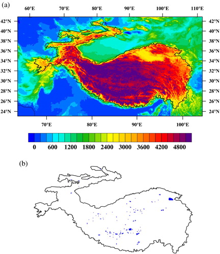
Two 11-year runs were conducted with the WRF model in our study. The control experiment (CTL) for the WRF model was configured with the model default settings, and the sensitivity experiment was carried out with the lakes filled in with the nearest land-use types as no-lake (NOL) simulations on the TP. The difference between the two experiments represents the effects of the TP lakes on the local and regional climate and hydrological cycles. Both runs were set at 10 km horizontal resolution, accounting for more than 80% of the TP lakes (b), when compared with MODIS data at 1 km resolution. The domain was centred at 35.7°N, 84.0°E and had 425 grid points along the east–west direction and 230 along the north–south direction, which covered the entire TP area (a). The Lambert projection was used in the WRF model, and the model consisted of 30 vertical layers, with the top layer set to 50 hPa. The initial lake surface temperature came from ERA-Interim reanalysis data in each run, and the model computed lake temperature based on the physical lake scheme.
Fig. 1 (a) Domain used in the WRF model and topography of the TP (m). (b) Lake distribution over the TP. The solid black line represents the profile of the TP.
The experiments in this study were conducted with the following atmospheric physics schemes: Dudhia shortwave radiation (Dudhia, Citation1989); Rapid Radiative Transfer Model (RRTM) longwave radiation (Mlawer, Taubman, Brown, Iacono, & Clough, Citation1997); Community Atmosphere Model, version 5.1 (CAM 5.1) microphysics (Neale et al., Citation2012); Kain–Fritsch cumulus scheme (Kain, Citation2004); the University of Washington planetary boundary layer physics (Bretherton & Park, Citation2009); CLM 4.0 land surface model (Jin & Wen, Citation2012; Lawrence & Chase, Citation2010; Oleson et al., Citation2010), and CLM 4.5 lake model (Gu et al., Citation2013; Oleson et al., Citation2013). The 2000–2010 period was selected for our simulations in this study. To avoid potential climate drift, the simulation for each year ran individually, which was started at 0000 utc 1 September of the previous year to avoid snow initialization over most areas on the TP and then ran for 16 months. The simulations for the first four months of the previous year were discarded as a spin-up process, and the simulations for the remaining 12 months were analyzed. The deeper the lake, the more spin-up time is needed. According to Gu et al. (Citation2013), a four-month spin-up time is sufficient for lake temperature simulations with the WRF model for the Great Lakes, which are much deeper than the lakes on the TP. Thus, it seemed that a four-month spin-up time would work well for temperature simulations for the TP lakes.
3 Results
a WRF model evaluation over the TP
Before the two simulations were performed for this study, we conducted a series of runs to select the optimal physical schemes through sensitivity simulations (not shown). Computation of the pattern correlation coefficients and root mean square errors with observations allowed us to select the physical schemes with the best performance for the TP regional climate simulations.
With the optimal schemes selected for this study, the skill of the WRF model in simulating climate over the TP was evaluated with ITP data. shows the spatial patterns of observed and simulated annual mean precipitation and 2 m height air temperature for 2000 to 2010. Because the observational data cover only China, we focused mainly on the Chinese part of the TP. It can be seen that the annual mean precipitation decreases rapidly northwestward in the observations (a). The maximum precipitation (more than 1000 mm yr−1) occurs along the southeastern edge, where the elevation is relatively low. The TP-averaged annual precipitation in a illustrates that precipitation reaches its maximum value during the summer monsoon season, when the value exceeds 90 mm mo−1. During the summer, water vapour from the southern hemisphere reaches the southern slope of the TP and is lifted by the mountains, generating a large amount of precipitation in the region (Wu, Guan, et al., Citation2012; Wu, Liu, et al., Citation2012). However, the northwestern TP is little influenced by the summer monsoon (Yao et al., Citation2012), leading to less precipitation there. During winter, most areas of the TP are controlled by dry westerlies (Yang et al., Citation2014), where the domain-averaged precipitation is usually less than 10 mm mo−1.
Fig. 2 Annual mean precipitation (mm yr−1) and 2 m height air temperature (°C) from the observations (ITP) and CTL for 2000–2010, and the difference between CTL and NOL: (a) observed precipitation; (b) simulated precipitation; (c) difference in precipitation; (d) observed temperature; (e) simulated temperature; and (f) difference in temperature.
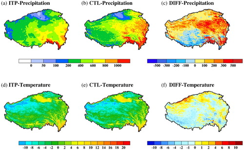
Fig. 3 Annual mean monthly (a) precipitation (mm mo−1) and (b) 2 m height air temperature (°C) averaged over the TP for 2000–2010. The curve with solid circles shows the observations (ITP), and the curve with open squares shows the simulation results from the CTL run.
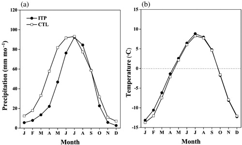
Compared with observations, the WRF model captures the basic spatial pattern of precipitation well over the TP ((b)). However, based on the spatial distribution map of the biases (c), the largest positive bias, exceeding 500 mm yr−1, occurs on the southeastern slope. At the same time, the WRF model underestimates precipitation over the southwestern TP, with negative biases lower than −500 mm yr−1. Based on the precipitation time series (b), higher simulated precipitation is seen during the first half of the year. The observed value averaged from January to June is 29 mm mo−1, but the WRF model produces precipitation of 49 mm mo−1. Large biases in precipitation simulations are also found in simulations with global climate models. A study conducted by Su, Duan, Chen, Hao, and Cuo (Citation2013) showed that many global climate models from phase five of the Coupled Model Intercomparison Project (CMIP5) drastically overestimated precipitation over the TP by 62–183%. Compared with those simulations, the results from our study, with a 31% annual mean bias in precipitation, are a significant improvement due to the more realistic physical schemes and high model resolution (10 km). In general, the model does an excellent job of simulating the decay phase of precipitation over the TP. The mean bias averaged over July to December is just 2 mm mo−1.
d shows the observed 2 m height air temperature over the 2000–2010 period. Temperature over the TP decreases from the southeast to the northwest, consistent with the increasing elevation (a). The warmest climate appears on the eastern TP, with the annual mean temperature exceeding 10°C. Because of its lower elevation, the Qaidam Basin also shows a warmer climate than areas at the same latitude on the TP. There are cold areas located on the central and western TP, and the annual mean air temperature in some places is lower than the freezing point. Most of these areas have an elevation higher than 5 km, and a large number of glaciers are found there (Yao, Pu, Lu, Wang, & Yu, Citation2007). The coldest area appears on the northwestern edge of the TP, with an average temperature lower than −10°C. As we can see in e, the spatial pattern of simulated air temperature is quite similar to the observations although the model underestimates the temperature on the southwestern TP and overestimates it on the northern edge of the TP (f). The large positive and negative biases are greater than 2°C and lower than −2°C, respectively. To some extent, these biases are speculated to be related to the unrealistic description of the complex terrain at the 10 km resolution of the WRF model because of the larger biases occurring mainly on the steep slopes. However, the physical schemes may still have played a role in such erroneous simulations, which are difficult to evaluate because of the lack of observations, especially in the very complex terrain on the TP. The uncertainties in ERA-Interim and ITP data may also contribute to the biases in the simulations. Nevertheless, the model accurately reproduces the time series of seasonal variation in temperature on the TP (b), and the domain-averaged mean bias is only 0.45°C for the 11-year study period, which is much smaller than the bias of 1.1°–2.5°C in CMIP5 models (Su et al., Citation2013).
Overall, the eastern TP has a warm and moist climate because of its relatively lower elevation and the influence of Asian monsoons, while the western and northern TP show a cold and dry climate under the influence of westerlies (Yang et al., Citation2014). Despite these biases, the WRF simulations agree relatively well with observations. The results from the TP climate simulations provide high confidence for conducting further sensitivity experiments related to the role of lakes in the TP climate system.
b Impact of the lakes on local climate
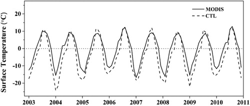
The results in Gu et al. (Citation2013) showed that the lake model coupled with the WRF model can simulate the physical processes in shallow lakes well (lake depth <50 m). On the TP, most lakes are shallow, based on lake depth data from Kourzeneva (Citation2010). The seasonal cycles of lake surface temperature measured with MODIS data for Lake Ngoring, the largest lake in the Yellow River source region, with an area of about 610 km2, are given in . Despite the occurrence of cold biases, the WRF–lake model can reproduce the variation in surface temperature reasonably well, showing the reliability of the model in climate simulations.
Fig. 4 Surface temperature (°C) of the MODIS data (solid line) and the CTL run (dashed line) for Lake Ngoring.
We investigated the influence of TP lakes on local and regional climate in this study. For the NOL run, the lake type on the TP was changed to the nearest land-use type, such as grassland or bare or sparsely vegetated. shows the surface variable differences averaged over the lake areas between the CTL and NOL experiments. As shown in a, the lakes have a cooling role on the surface over almost the entire year (except October) compared with the run without the lakes (NOL). The maximum reduction (6.6°C) occurs in April, and a minor increase (0.6°C) occurs in October. It is commonly known that the lakes have a larger heat capacity, resulting in a slower warm-up than the nearby land surface. In addition, during the cold season, the TP lakes are often covered with ice, leading to a higher surface albedo and thus a lowering of surface temperature. The lakes also act as a heat sink during the warm season (Long, Perrie, Gyakum, Caya, & Laprise, Citation2007; Stepanenko et al., Citation2013). When solar radiation begins to decrease after summer, the heat stored in the lower part of the lake starts to move to the surface, preventing the lake surface temperature from decreasing quickly. Such a process is the likely cause of the lake surface temperature being higher than that of the land surface in October. The changes in near-surface wind speed induced by the lakes are given in b. The wind speed decreases over the lakes during the winter and spring, with the largest reduction being 0.44 m s−1 occurring in April. During the summer and fall, the wind over the lakes becomes stronger than that over the land surface, with a maximum value of 0.44 m s−1 in August.
Fig. 5 Seasonal differences in surface variables of TP lakes between CTL and NOL: (a) surface skin temperature (°C); (b) 10 m height wind speed (m s−1); and (c) surface sensible (grey bars), and latent (light grey bars) heat flux (W m−2).
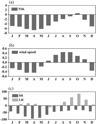
Surface heat fluxes on the lake surface are the main force in changing the atmospheric boundary layer over the lakes (Haginoya et al., Citation2009; Xiao et al., Citation2013). c shows the differences in sensible and latent heat fluxes between the model with lakes and the model in which the lakes have been replaced with the nearest land-use types. The sensible heat flux differences are generally consistent with the temperature changes in a, decreasing over the entire year. The largest decrease (−93 W m−2) occurs in April, and the smallest reduction (−29 W m−2) is seen in October. The changes in latent heat flux are quite different from those of sensible heat flux. Most differences are very minor, except for those in the fall, when evaporation is enhanced quite significantly over the lakes, as seen in b. The largest latent heat flux increase occurs in October, with a value of 85 W m−2. In October, the monsoon ends and dry air from the north and west prevails over the TP; at the same time, the lake surface is still warm because of heat stored in the lake during the previous warm season, thus encouraging a large amount of evaporation. In addition, the stronger wind in the fall (b) strengthens heat diffusion, increasing latent heat release in October.
Overall, the presence of the lakes cools the surface over almost the entire year. The wind weakened in the spring and winter but strengthened in the other two seasons. The sensible heat flux on TP lakes is always lower than that on the land surface, while the latent heat flux is stronger during the fall. The lakes also influence the vertical temperature profile, which strengthens the stability of the atmosphere above them with their cooling processes.
c Impact of the lakes on summer precipitation
The difference in precipitation between CTL and NOL is significant during the summer (a) and insignificant during the other seasons (not shown). Here we show only the spatial pattern of the mean precipitation difference during the summer (a). Suppressed precipitation (5–20 mm mo−1) appears over areas where lakes are concentrated. This is partly because the more stable lower atmosphere induced by the cooling effect of the lakes discourages precipitation formation. At the same time, increased precipitation is seen near southern Lake Qinghai and on the southern TP, increasing by 5–25 mm mo−1, which is often related to the large-scale circulation triggered by the lakes (Sousounis, Citation1997). Such paired decreasing and increasing precipitation patterns are very common near lakes (Lofgren, Citation1997; Sousounis & Mann, Citation2000; Thiery et al., Citation2015). Changes in precipitation are also seen over other areas of the TP that do not have a strong influence from lakes, but the magnitude is very minor, mostly less than 3 mm m−1. The Student's-t test shows that the precipitation differences over 43% of the lake grids are significant at the 95% confidence level (in the model there are a total of 282 lake grids on the TP), but over most other areas of the TP the differences are not significant. Our results show that the lakes affect mesoscale precipitation over and around the lakes more significantly than in other regions.
Fig. 6 Differences in (a) monthly precipitation (mm mo−1), (b) geopotential height (m) at 500 hPa, (c) geopotential height (m) at 200 hPa, (d) wind fields (m s−1) at 500 hPa and (e) wind fields (m s−1) at 200 hPa in summer between CTL and NOL. The closed line in (a) indicates the locations of the TP lakes.
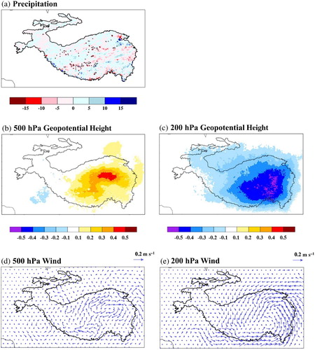
In the geopotential height and wind difference fields at the 200 and 500 hPa levels between CTL and NOL (CTL minus NOL) (b–e), a cyclonic circulation anomaly forms at the 200 hPa level, and an anticyclonic circulation anomaly forms around the lakes at the 500 hPa level. The cooling effect of the lakes leads to cooler air accumulating in the lower atmosphere over the lakes, resulting in increased near-surface pressure (geopotential height) on the central TP (b), and thus an anticyclonic circulation. The divergence of the higher pressure in the lower atmosphere induces a convergent cyclonic flow in the upper levels. Such a structure in the atmospheric column suppresses air convection and reduces precipitation. Additionally, mesoscale circulations form where cyclonic flows appear at 500 hPa over the southern TP, resulting in an increase in precipitation over this region. The wind field over regions outside the TP also experiences some changes induced by the lakes on the TP, indicating that the lakes affect not only local climate and circulation but remote conditions as well.
4 Conclusions and discussion
In our study, we have fully evaluated the coupled WRF–lake model using observations and have ensured that the model can simulate the climate over the TP reasonably well. The simulated precipitation and near-surface air temperature agree well with observational data in the spatial and temporal domains. The results demonstrate that the WRF model performs well in modelling the climate of the TP, providing a reliable tool to carry out sensitivity experiments to investigate the role of the TP lakes in the regional climate system.
The effects of TP lakes on surface processes and vertical air columns are explored by comparing experiments with and without TP lakes. The results illustrate that the lakes lower the surface temperature and sensible heat flux for almost the entire year, with the strongest influence occurring in spring. The wind over the lakes is weakened in the spring and winter but strengthened in the summer and fall when compared with the wind over the land surface. The lakes’ existence also enhances evaporation during the fall. The cooling processes of the lakes also make the lower atmosphere more stable and generate an anticyclonic circulation in the lower atmosphere and a cyclonic circulation in the upper atmosphere over the areas where lakes are concentrated on the TP, leading to decreased precipitation. In addition, increased precipitation over some areas of the TP is associated with the mesoscale circulation induced by the lake processes.
Our study focused mainly on understanding the role of the TP lakes in the climate system with a realistic regional climate model through sensitivity tests, while most other studies focus on particular lakes whose physical characteristics are often different than those of other lakes. However, some common characteristics of all the TP lakes in our simulation are also found in individual lakes. For instance, the results of our study show that the largest sensible and latent heat fluxes occur in the fall (not shown), and similar conclusions were drawn by Li et al. (Citation2016) in a study of Lake Qinghai with observed data and from Haginoya et al. (Citation2009) and Lazhu et al. (Citation2016) in a study of Nam Co using modelling approaches.
However, some uncertainties in our simulations deserve attention. We used ITP data as the observational data in this study. In this dataset, precipitation data are a combination of meteorological station observations and TRMM data. However, meteorological stations are very sparse in the western part of the TP; thus, the TRMM satellite data cannot be well calibrated for this part of the region, which could generate uncertainties in the ITP data.
In addition, the model still has some disadvantages in simulating lake processes on the TP. The current version of the lake model in the WRF model is a freshwater model and does not consider salinity in the lake water. However, most TP lakes are saline. It is still unknown how the salinity of the lakes affects lake processes because the salinity data in these lakes are not publicly available or do not exist. This issue needs to be addressed in future studies. In addition, lake depth is an important parameter that affects lake heat content, which can further alter lake processes. However, the accuracy of many lake depth data for the TP included in the model is not quantitatively evaluated with observations. Such observations are not available for many lakes on the TP. Thus, the potential biases in lake depth data could affect the accuracy of the simulations of lake processes on the TP.
Acknowledgements
We thank Guoqi Han and the anonymous reviewers for their constructive comments from this study. The ITP data used in this research are accessible from the Third Pole Environment Database (http://en.tpedatabase.cn/portal/MetaDataInfo.jsp?MetaDataId=202). The MODIS lake surface temperature data products (MOD11C3 and MYD11C3) can be obtained from https://modis.gsfc.nasa.gov/data/dataprod. The ERA-Interim data were downloaded from http://apps.ecmwf.int/archive-catalogue.
Disclosure statement
No potential conflict of interest was reported by the authors.
Additional information
Funding
References
- Bates, G. T., Giorgi, F., & Hostetler, S. W. (1993). Toward the simulation of the effects of the Great Lakes on regional climate. Monthly Weather Review, 121(5), 1373–1387.
- Bian, D., Bianba, B., La, C., Wang, C., & Chen, T. (2010). The response of water level of Selin Co to climate change during 1975–2008. Acta Geographica Sinica, 65(3), 313–319.
- Bretherton, C. S., & Park, S. (2009). A new moist turbulence parameterization in the community atmosphere model. Journal of Climate, 22, 3422–3448.
- Chen, Y., Yang, K., He, J., Qin, J., Shi, J., Du, J., & He, Q. (2011). Improving land surface temperature modeling for dry land of China. Journal of Geophysical Research, 116, D20104. doi: 10.1029/2011JD015921
- Dee, D. P., Uppala, S. M., Simmons, A. J., Berrisford, P., Poli, P., Kobayashi, S., … Vitart, F. (2011). The ERA-Interim reanalysis: Configuration and performance of the data assimilation system. Quarterly Journal of the Royal Meteorological Society, 137, 553–597.
- Dudhia, J. (1989). Numerical study of convection observed during the winter monsoon experiment using a mesoscale two-dimensional model. Journal of Atmospheric Sciences, 46, 3077–3107.
- Dutra, E., Stepanenko, V. M., Balsamo, G., Viterbo, P., Miranda, P. M. A., Mironov, D., & Schar, C. (2010). An offline study of the impact of lakes on the performance of the ECMWF surface scheme. Boreal Environment Research, 15, 100–112.
- Fu, R., Hu, Y., Wright, J., Jiang, J., Dickinson, R., Chen, M., … Wu, D. (2006). Short circuit of water vapor and polluted air to the global stratosphere by convective transport over the Tibetan Plateau. Proceedings of the National Academy of Sciences, 15(103), 5664–5669.
- Gu, H., Jin, J., Wu, Y., Ek, M. B., & Subin, Z. M. (2013). Calibration and validation of lake surface temperature simulations with the coupled WRF-lake model. Climatic Change, 129(3-4), 471–483.
- Guo, D., & Wang, H. (2013). Simulation of permafrost and seasonally frozen ground conditions on the Tibetan Plateau, 1981–2010. Journal of Geophysical Research: Atmospheres, 118, 5216–5230. doi:10.1002/jgrd.50457, 2013
- Haginoya, S., Fujii, H., Kuwagata, T., Xu, J., Ishigooka, Y., Kang, S., & Zhang, Y. (2009). Air-lake interaction features found in heat and water exchanges over Nam Co on the Tibetan Plateau. SOLA, 5, 172–175. doi:10.2151/sola.2009–044
- He, J. (2010). Development of a surface meteorological dataset of China with high temporal and spatial resolution (Master’s thesis, Institute of Tibetan Plateau Research, Chinese Academy of Science). [in Chinese].
- Huffman, G. J., Adler, R. F., Bolvin, D. T., Gu, G., Nelkin, E. J., Bowman, K. P., … Wolff, D. B. (2007). The TRMM multi-satellite precipitation analysis (TMPA): Quasi-global, multi-year, combined-sensor precipitation estimates at fine scales. Journal of Hydrometeorology, 8, 38–55. doi: 10.1175/JHM560.1
- Immerzeel, W. W., Van Beek, L. P., & Bierkens, M. F. (2010). Climate change will affect the Asian water towers. Science, 328(5984), 1383–1385.
- Jin, J., & Wen, L. (2012). Evaluation of snowmelt simulation in the Weather Research and Forecasting model. Journal of Geophysical Research, 117, D10110. doi: 10.1029/2011JD016980
- Kain, J. S. (2004). The Kain-Fritsch convective parameterization: An update. Journal of Applied Meteorology and Climatology, 43, 170–181.
- Kourzeneva, E. (2010). External data for lake parameterization in numerical weather prediction and climate modeling. Boreal Environment Research, 15, 165–177.
- Lawrence, P. J., & Chase, T. N. (2010). Investigating the climate impacts of global land cover change in the community climate system model. International Journal of Climatology, 33, 1470–1481. doi: 10.1002/joc.2061
- Lazhu, K. Y., Wang, J., Lei, Y., Chen, Y., Zhu, L., Ding, B., & Qin, J. (2016). Quantifying evaporation and its decadal change for Lake Nam Co, central Tibetan Plateau. Journal of Geophysical Research: Atmospheres, 121, 7578–7591. doi: 10.1002/2015JD024523
- Lei, Y., Yang, K., Wang, B., Sheng, Y., Bird, B. W., Zhang, G., & Tian, L. (2014). Response of inland lake dynamics over the Tibetan Plateau to climate change. Climatic Change, 125, 281–290.
- Lei, Y., Yao, T., Bird, B. W., Yang, K., Zhai, J., & Sheng, Y. (2013). Coherent lake growth on the central Tibetan Plateau since the 1970s: Characterization and attribution. Journal of Hydrology, 483(3), 61–67.
- Leon, L. F., Lam, D. C.-L., Schertzer, W., Swayne, D. A., & Imberger, J. (2007). Towards coupling a 3D hydrodynamic lake model with the Canadian Regional Climate Model: Simulation on Great Slave Lake. Environmental Modelling & Software, 22(6), 787–796.
- Li, X., Ma, Y., Huang, Y., Hu, X., Wu, X., Wang, P., … Liu, L. (2016). Evaporation and surface energy budget over the largest high-altitude saline lake on the Qinghai-Tibet Plateau. Journal of Geophysical Research: Atmospheres, 121(18), 10470–10485. doi: 10.1002/2016JD025027
- Liu, J., Wang, S., Yu, S., Yang, D., & Zhang, L. (2009). Climate warming and growth of high-elevation inland lakes on the Tibetan Plateau. Global & Planetary Change, 67, 209–217.
- Lofgren, B. M. (1997). Simulated effects of idealized Laurentian Great Lakes on regional and large-scale climate. Journal of Climate, 10, 2847–2858.
- Long, Z., Perrie, W., Gyakum, J., Caya, D., & Laprise, R. (2007). Northern lake impacts on local seasonal climate. Journal of Hydrometeorology, 8, 881–896.
- Ma, Y., Wang, Y., Wu, R., Hu, Z., Yang, K., Li, M., … Ishikawa, H. (2009). Recent advances on the study of atmosphere-land interaction observations on the Tibetan Plateau. Hydrology and Earth System Sciences, 13(7), 1103–1111.
- Meng, K., Shi, X., Wang, E., & Liu, F. (2011). High-altitude salt lake elevation changes and glacial ablation in central Tibet, 2000–2010. Chinese Science Bulletin, 57(5), 525–534.
- Mlawer, E., Taubman, S., Brown, P., Iacono, M., & Clough, S. (1997). Radiative transfer for inhomogeneous atmosphere: RRTM, a validated correlated-k model for the long-wave. Journal of Geophysical Research, 102(D14), 16663–16682.
- Neale, R., Chen, C.-C., Gettelman, A., Lauritzen, P., Park, S., Williamson, D., … Taylor, M. (2012). Description of the NCAR Community Atmosphere Model (CAM5.0). NCAR Technical Note, NCAR/TN-486+STR, Boulder, Colorado: National Center for Atmospheric Research.
- Neckel, N., Kropáček, J., Bolch, T., & Hochschild, V. (2014). Glacier mass changes on the Tibetan Plateau 2003–2009 derived from ICESat laser altimetry measurements. Environmental Research Letters, 9(1), 014009. doi: 10.1088/1748-9326/9/1/014009
- Oleson, K. W., Dai, Y., Bonan, G., Bosilovich, M., Dickinson, R., Dirmeyer, P., … Zeng, X. (2013). Technical description of the community land model (CLM). NCAR Technical Note. NCAR/TN-503+STR, Boulder, Colorado: National Center for Atmospheric Research.
- Oleson, K. W., Lawrence, D. M., Bonan, G. B., Flanner, M. G., Kluzek, E., Lawrence, P. J., … Zeng, X. (2010). Technical description of version 4.0 of the community land model. NCAR Technical Note, NCAR/TN-478+STR, 257, Boulder, Colorado: National Center for Atmospheric Research.
- Phan, V. H., Roderik, L., & Massimo, M. (2012). ICESat derived elevation changes of Tibetan lakes between 2003 and 2009. International Journal of Applied Earth Observation and Geoinformation, 17, 12–22.
- Qiu, J. (2008). The third pole. Nature, 454, 393–396. doi: 10.1038/454393a
- Rouse, W. R., Oswald, C. J., Binyamin, J., Spence, C. R., Schertzer, W. M., Blanken, P. D., … Duguay, C. R. (2005). The role of northern lakes in a regional energy balance. Journal of Hydrometeorology, 6(3), 291–305.
- Samuelsson, P., Kourzeneva, E., & Mironov, D. (2010). The impact of lakes on the European climate as simulated by a regional climate model. Boreal Environmental Research, 15, 113–129.
- Sheffield, J., Goteti, G., & Wood, E. F. (2006). Development of a 50-year high-resolution global dataset of meteorological forcings for land surface modeling. Journal of Climate, 19, 3088–3111. doi: 10.1175/JCLI3790.1
- Skamarock, W. C., Klemp, J. B., Dudhia, J., Gill, D. O., Barker, D. M., Duda, M. G., … Powers, J. G. (2008). A description of the advanced research WRF version 3. NCAR Technical Notes, NCAR/TN-475+STR, Boulder, Colorado: National Center for Atmospheric Research.
- Song, C., Huang, B., & Ke, L. (2014). Inter-annual changes of alpine inland lake water storage on the Tibetan Plateau: Detection and analysis by integrating satellite altimetry and optical imagery. Hydrological Processes, 28(4), 2411–2418.
- Sousounis, P. J. (1997). Lake-aggregate mesoscale disturbances. Part III: Description of a mesoscale aggregate vortex. Monthly Weather Review, 125, 1111–1134.
- Sousounis, P. J., & Mann, G. G. (2000). Lake-aggregate mesoscale disturbances. Part V: Impacts on lake-effect precipitation. Monthly Weather Review, 128, 728–745.
- Stepanenko, V. M., Martynov, A., Johnk, K. D., Subin, Z. M., Perroud, M., Fang, X., … Goyette, S. (2013). A one-dimensional model intercomparison study of thermal regime of a shallow, turbid midlatitude lake. Geoscientific Model Development, 6, 1337–1352.
- Su, F., Duan, X., Chen, D., Hao, Z., & Cuo, L. (2013). Evaluation of the global climate models in the CMIP5 over the Tibetan Plateau. Journal of Climate, 26(10), 3187–3208.
- Subin, Z. M., Riley, W. J., & Mironov, D. (2012). An improved lake model for climate simulations: Model structure, evaluation, and sensitivity analyses in CESM1. Journal of Advances in Modeling Earth Systems, 4(1), 1–27.
- Swayne, D., Lam, D., MacKay, M., Rouse, W., & Schertzer, W. (2005). Assessment of the interaction between the Canadian Regional Climate Model and lake thermal–hydrodynamic models. Environmental Modelling & Software, 20, 1505–1513.
- Thiery, W., Davin, E. L., Panitz, H., Demuzere, M., Lhermitte, S., & Nicole, V. L. (2015). The impact of the African Great Lakes on the regional climate. Journal of Climate, 28, 4061–4085. doi: 10.1175/JCLI-D-14-00565.1
- Wang, B., Bao, Q., Hoskins, B., Wu, G., & Liu, Y. (2008). Tibetan Plateau warming and precipitation changes in east Asia. Geophysical Research Letters, 35(14), 63–72.
- Wu, G., Guan, Y., Liu, Y., Yan, J., & Mao, J. (2012). Air–sea interaction and formation of the Asian summer monsoon onset vortex over the Bay of Bengal. Climate Dynamics, 38(1–2), 261–279. doi: 10.1007/s00382-010-0978-9
- Wu, G., Liu, Y., He, B., Bao, Q., Duan, A., & Jin, F. (2012). Thermal controls on the Asian summer monsoon. Scientific Reports, 2, 404, 1–7.
- Xiao, W., Liu, S., Wang, W., Yang, D., Xu, J., Cao, C., … Lee, X. (2013). Transfer coefficients of momentum, heat and water vapor in the atmospheric surface layer of a large freshwater lake. Boundary-Layer Meteorology, 148(3), 479–494.
- Yang, K., Wu, H., Qin, J., Lin, C., Tang, W., & Chen, Y. (2014). Recent climate changes over the Tibetan Plateau and their impacts on energy and water cycle: A review. Global and Planetary Change, 112, 79–91.
- Yao, T., Pu, J., Lu, A., Wang, Y., & Yu, W. (2007). Recent glacial retreat and its impact on hydrological processes on the Tibetan Plateau, China, and surrounding regions. Arctic Antarctic and Alpine Research, 39(4), 642–650.
- Yao, T., Thompson, L., Yang, W., Yu, W., Gao, Y., Guo, X., … Joswiak, D. (2012). Different glacier status with atmospheric circulations in Tibetan Plateau and surroundings. Nature Climate Change, 2, 663–667. doi: 10.1038/nclimate1580
- Yao, T., Wang, Y., Liu, S., Pu, J., Shen, Y., & Lu, A. (2004). Recent glacial retreat in high Asia in China and its impact on water resource in northwest China. Science China-Earth Sciences, 47, 1005–1075.
- Yatagai, A., Arakawa, O., Kamiguchi, K., Kawamoto, H., Nodzu, M. I., & Hamada, A. (2009). A 44-year daily gridded precipitation dataset for Asia based on a dense network of rain gauges. SOLA, 5, 137–140. doi: 10.2151/sola.2009-035
- Zhang, G., Xie, H., Kang, S., Yi, D., & Ackley, S. F. (2011). Monitoring lake level changes on the Tibetan Plateau using ICESat altimetry data (2003–2009). Remote Sensing of Environment, 115(7), 1733–1742.
- Zhang, G., Yao, T., Xie, H., Zhang, K., & Zhu, F. (2014). Lakes’ state and abundance across the Tibetan Plateau. Chinese Science Bulletin, 59, 3010–3021.
- Zhang, R., Jiang, D., Liu, X., & Tian, Z. (2012). Modeling the climate effects of different subregional uplifts within the Himalaya-Tibetan Plateau on Asian summer monsoon evolution. Chinese Science Bulletin, 57, 4617–4626.
- Zhang, R., Jiang, D., Zhang, Z., & Yu, E. T. (2015). The impact of regional uplift of the Tibetan Plateau on the Asian monsoon climate. Palaeogeography Palaeoclimatology Palaeoecology, 417, 137–150.
- Zhao, L., Jin, J., Wang, S., & Ek, M. B. (2011). Integration of remote-sensing data with WRF to improve lake-effect precipitation simulations over the Great Lakes region. Journal of Geophysical Research: Atmospheres, 117(D9), 537–555.
- Zhu, L., Xie, M., & Wu, Y. (2010). Quantitative analysis of lake area variations and the influence factors from 1971–2004 in the Nam Co basin of the Tibetan Plateau. Chinese Science Bulletin, 55, 1294–1303.