
ABSTRACT
Between 1950 and 1990, housing was the driving force behind the spatial growth of the Randstad. Growth poles (1970s) and later VINEX locations (1990–2010) were the main components of growth management. Transport infrastructure has developed greatly since the 1920s. Since 1990, infrastructure development has increasingly become the structuring force for the spatial dynamics of the Randstad. Schiphol was seen as the mainport for airlines, and Rotterdam-Europoort as the mainport for shipping lines and container transport. The landside infrastructural connections for Schiphol and Europoort had a big impact on the growth in the capacity of continental roads and rail lines. ICT- and energy infrastructure are now developing quickly. Recently, Amsterdam Internet Exchange became the largest ICT node in Europe. Finally, the Delta programme was introduced, strengthening the coastal areas and leaving more room for the rivers. For the future, a combination of housing, infrastructure and water for spatial developments will determine the spatial structure of the Randstad further. A compartmentalized plan of the Randstad between the main dikes is presented, which will increase the resilience of functions of the Randstad in the future when the North Sea level is expected to rise substantially. The analysis presented could be relevant for many urban deltas worldwide.
1. Introduction and purpose of the study
The purpose of the study is to find out which components explain the spatial development of the Randstad Holland since the Second World War. Zonneveld (Citation1991, pp. 187–207) shows that Dutch spatial planners have for many years adopted a dichotomy: Western Netherlands and the rest. After 1992, the main focus shifted to the relationship between the Netherlands and the world.
The research strategy implies that references about spatial planning and planning documents on the spatial structure of the Randstad are studied. On a number of topics, the relations are specified with theoretical planning literature. This leads to two new insights: (a) The shift from housing as a driving force of Dutch spatial planning to infrastructure as a driving force; (b) The way water issues will determine the spatial structure of the Randstad in the future. In this aspect, our analysis could be relevant for urban deltas elsewhere in the world.
In addition, the paper relates to broader literature on city development, regional growth and spatial, housing and infrastructure planning (Castells, Citation1989; Hall, Citation1998; Priemus, Button, & Nijkamp, Citation2007; Sassen, Citation1991; Vickerman, Citation2000).
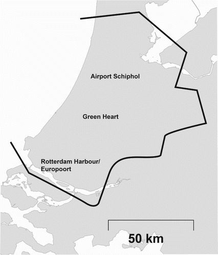
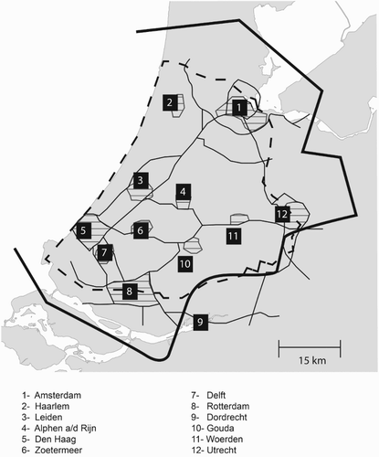
presents the current Randstad area.
Figure 1. Randstad Holland.
The idea of the Randstad was developed in the 1950s, in the form of a ‘conurbation’ around the Green Heart, including blue chambers (lakes). The Randstad was presented as an urban region connecting the Netherlands with other parts of the world, to a large extent via the harbour of Rotterdam and Schiphol Airport Amsterdam.
In 1966, the National Government proposed a large number of new motor roads in the Structure Scheme Main Roads Net, some of which crossed the Green Heart and the (larger) central open space (Zonneveld, Citation1991, p. 193). These plans were partially abandoned in the seventies. The Urbanization Memorandum (Ministerie van VROM, Citation1976) made the Randstad concept visible and presented a clear profile of the Green Heart. In the recent past, several interests supporting spatial development in general and urban dynamics in particular were identified.
The interaction between spatial planning and housing development is well known, especially in periods of demographic and economic growth. In many European countries, the demographic growth slowed down after a spectacular baby boom in the sixties. As a logical consequence, the driving force of housing in Dutch spatial planning decreased after 1990. Other domains like the environment, traffic infrastructure and water management gained ground. But how did this happen? Which topics should be included to the analysis of spatial development in the Randstad? This paper tries to fill this gap of knowledge: how did not only housing but also transport and environmental issues and water management form the Randstad? And how can the resilience of the Randstad be strengthened in the future when the sea level rises further?
Our study is focused on the western urbanized part of the Netherlands, including cities like Amsterdam, Rotterdam, The Hague, Utrecht, Leiden, Haarlem and Dordrecht, situated mostly lower than sea level: the Randstad Holland. This area became urbanized in the middle ages, not by the development of very large cities like London, Paris and Madrid, but primarily by the development of polynuclear regions with medium sized and even small cities (Berry, Citation1964). This Western European pattern can also be found in Belgium (the Flemish Diamond) and Germany (the Rhein-Ruhr Area). When, in the beginning of the twentieth century, a location had to be found for Schiphol Airport the so-called Green Heart appeared to be an ideal place: close to many cities in Holland, close to the oceans for intercontinental flights, and a lot of meadows around, giving room for arriving and departing planes. Schiphol Airport grew quickly and became one of the five largest airports in Europe. In the meantime, a dilemma for the Green Heart developed: on the one hand, this area became attractive for agriculture, horticulture, open air recreation with nice landscapes and a typical Dutch mix of nature and culture. On the other hand, the land had an increasing value with a growing number of jobs around and it functioned as a node for continental and intercontinental airlines, including surface connections with cars and trains to cities in continental Europe. Spatial planners, who since the 1920s have designed the National Main Roads Plan (Rijkswegennet) created the A5 highway, directly connecting Amsterdam and Rotterdam. This connection was eliminated later from the national plan, because such a highway would be an infringement on the green character and quiet atmosphere of large parts of the Green Heart. More and more households discovered the Green Heart as an attractive housing location: a green environment, close to jobs in the urban ring around the Green Heart. The market increased its pressure on the Green Heart, and spatial planners tried to keep this area green. This is the stage for spatial dilemmas which have occurred in the Randstad Holland for a long time. In particular, in this area, evidence can be observed of different and changing views on the dominant spatial planning concepts (Zonneveld, Citation1991).
In the period 1945–2000, spatial development of the Randstad was mainly a matter of growth management (Carruthers, Citation2002). Housing construction was the main driver of spatial policy since the 1920s. Growth poles policy (in the 1970s) and VINEX policy (VINEX = Vierde Nota Ruimtelijke Ordening Extra: Ministerie van VROM, Citation1990) were formulated and realized. A policy of regulated suburbanization was conducted. In the period of industrialization, it was almost impossible to find or maintain locations for industrial plants in the city. The preferred location for both housing and business parks became the edge city (Garreau, Citation1991) and the suburb, not too far from the city. Both within and beyond the Randstad, the economic development of the central cities was favoured less than the economic development of the surrounding region. At different times, urban renewal of the pre-war urban areas and new urban renewal of the post-war housing stock became high-priority policy domains, supporting the cities.
Since the end of the twentieth century, the urban economy has been increasingly dominated by personal and business services, creativity and knowledge. For these activities, the large cities appear to be the ideal production environments where face-to-face contacts and international ICT-communication can be combined (Graham & Marvin, Citation1996). Since about 2000, the population of Dutch cities has no longer decreased but started increasing, for both economic and demographic reasons ().
Table 1. Growth of population, Amsterdam, Rotterdam, The Hague, Utrecht, 2000–2016.
Since the turn of the century, infrastructure development (for transport, but also for ICT and energy) has been increasingly focused on restructuring the Randstad in a spatial sense. This tendency has led to more concentration and more synergy between infrastructure and urban networks. On a regional level, we speak of ‘network cities’ and on the level of the whole Randstad of ‘urban networks’. In a simplified way, we can characterize the spatial development of the Randstad before and after 1990 in the following way (see ).
Table 2. Aspects of spatial development of the Randstad before and after 1990.
My research strategy is primarily based on an analysis of national policy documents on spatial planning and related issues. In the sketch of the spatial policy development references are given, which include positive and negative agglomeration effects, borrowed size in polynuclear urban networks and city branding. These references do not make the findings new. The added value of this contribution is the adoption of a systems approach, which connects the different policies. This analysis leads to a new proposal to deal with the risk of flooding of large parts of the Randstad: compartmentalization of Dyke Ring 14. This approach, presented in section 6, combines water management with housing, environmental and infrastructure policy and provides an answer to the sea level rising, which could be dangerous for the Randstad Holland in the long run.
In section 2, the most important spatial policy documents since the 1960s are presented. The section continues by examining the sectors which have influenced the spatial structure of the Randstad over this period. Between 1950 and 1990, it was clearly the housing sector. New housing was in demand to meet the housing shortage after the Second World War as well as the demographic and economic growth. Section 3 examines this dynamic.
From about 1990 onwards, the goal of achieving a better economically competitive position for the Randstad was gaining ground. The economic climate of the Randstad was supported by better internal and external accessibility and an increase in the quality of life, including a healthier environment. The positive agglomeration effects of infrastructure with a larger capacity increasingly became the driving force for spatial development together with an increasing focus on ecology and sustainability. This is discussed in more detail in section 4.
Since about 2000, the government has acknowledged the importance of increased resilience to the rising sea level and to greater fluctuations in the volumes of water flowing through the Rhine, Meuse and Scheldt rivers. The Delta Programme defined an adaptation programme to the increasing rise in sea level, and was launched in 2008; since then, water has played an increasingly important role in creating a robust spatial structure for the Randstad. Section 5 considers this phenomenon more closely.
There is undoubtedly a sequential aspect to the influence of housing, infrastructure and water on spatial structure. However, there is evidence that, both now and in the future, these themes occur simultaneously and that it is most important to find an optimum by increasing the resilience of the Randstad, where housing, environment, infrastructure, water and nature are all taken into account. This theme is discussed further in section 6 alongside a presentation of the idea of compartmentalization of the Randstad area. As a result, synergy between housing, infrastructure, environmental and water issues can be achieved, where residential, business and infrastructures areas are, as much as possible, protected from flooding.
Section 7 presents some closing remarks.
2. National spatial policy, before and after 1990
The western urban region of the Netherlands consisting of the urban ring of cities like Amsterdam, Rotterdam, The Hague and Utrecht which surrounds the Green Heart with cultural landscapes, windmills, meadows and lakes is known as the Randstad. This area is bordered by the North Sea and lies mostly below sea level. The polycentric urban area initially flourished in the Golden Age, when the Netherlands sailed across the whole world and traded with continents in both the East and the West. The sea ports of Amsterdam and Rotterdam grew, as did the commercial and industrial cities of Leiden, Delft, Haarlem, Dordrecht and Utrecht.
In the twentieth century, after 1945, the relatively high birth rate, increased life expectancy and large numbers of immigrants contributed to a huge demographic growth. In the 1960s and 1970s, Dutch spatial planning focused on spatial dispersion. Peripheral regions were supported (such as East Groningen and the South Eastern Mining Area in Limburg) in an attempt to stimulate the economy in these areas and to reduce congestion in the west of the country. In 1966, the ‘Second Memorandum on Spatial Planning’ appeared, proposing a so-called concentrated deconcentration (Ministerie van Volkshuisvesting en Bouwnijverheid, Citation1966). The expected population by the year 2000 was more than 20 million. Eight years later, in 1974, the Orientation of Spatial Planning Memorandum appeared, intended as the first part of the Third Policy Document on Spatial Planning (Ministerie van Volkshuisvesting en Ruimtelijke Ordening, Citation1974). This document held on to the principle of concentrated deconcentration, placing the emphasis on concentration taking place in and around the cities. Environmental concerns began to make their mark on spatial policy.
The serious economic crisis at the beginning of the 1980s provided evidence that regional incentives had little effect; the market and not the government determined whether a business plant in Groningen was successful or not. In addition, the large cities in the Randstad surpassed the traditional problem areas in the region in terms of unemployment. Resistance to the policy of dispersal increased from the municipalities of Amsterdam, Rotterdam and The Hague.
2.1. Policy document ‘Spatial Perspectives’ (1986); Nota ‘Ruimtelijke Perspectieven’ (1986)
In order to defend the position of the Netherlands in the international ranking of urban areas the Randstad needed to be strengthened. This was the message in the policy document ‘Spatial Perspectives’, produced by the National Planning Department (Rijksplanologische Dienst, Citation1986), a document which marked a turning point. This document, which became the stimulus for the Fourth Memorandum on Spatial Planning, emphasized the international position of the Netherlands. This led to an emphasis on the spatial structure of the Randstad and move attention for the relation between spatial and infrastructure policy. In the Fourth Memorandum, launched by Minister Nijpels, the Randstad is placed clearly on the map (Ministerie van Volkshuisvesting, Ruimtelijke Ordening en Milieubeheer, Citation1988). One million new homes were to be built before 2015, Schiphol airport and the seaport of Rotterdam were to be further developed as strategic mainports, the high-speed linewould enable Amsterdam and Schiphol to join the European network of high-speed trains network, businesses needed to be more accessible and huge amounts of money would be invested in public transport. Further development of the peripheral regions would be facilitated without government funding.
2.2. Reprofiling
From the 1990 onwards, spatial planning focused more on compact cities, infrastructure and environmental policy (Priemus, Citation1990). The spatial impact of the earlier policy of dispersal combined with the new policy of compact cities resulted in a network of cities and urban networks. After 1990, urban renewal and urban compactness were central issues in urban planning (Dieleman, Dijst, & Spit, Citation1999). Before 1990, land use planning was primarily a public affair, with a number of well-known horizontal and vertical alignment problems. After 1990, the attitude to involving the private sector and the market in planning policy changed, as demonstrated by, for example, the Action Plan for Schiphol (Plan van Aanpak voor Schiphol). The aim was to strengthen the international competitiveness of the Netherlands, resulting in increasing pressure on the Randstad. Since then, the more peripheral regions have had to fend more for themselves. The tension between the Randstad as an attractive environment to live where stringent environmental requirements must be met and its international competitiveness was strengthened (Priemus, Citation1994). This became fully evident in the 1990s.
3. Housing determining spatial structure Randstad, before and after 1990
3.1. Growth Poles policy
After the Second World War, land use development in the Netherlands entered a period of growth. In the 1960s, 1970s and 1980s, the housing sector concentrated on building in new or existing centres close to the larger cities in order to accommodate the population growth in the Randstad (Faludi & van der Valk, Citation1990). In this period, the growth centre policy was applied, with large property subsidies and with the emphasis on social rented housing. It was an effective strategy for realizing large quantities of housing. Green areas were kept between the central cities and the growth centres, mostly for agriculture and outdoor recreation areas. Initially, most of the growth centres included a high proportion of high-rise buildings. Outside the ring of the Randstad, the growth centres (Lelystad, Purmerend, Spijkenisse, Hellevoetsluis) developed as sleeping cities whereas growth centres within the ring (Zoetermeer, Capelle aan den IJssel, Houten) attracted shops, offices, business and work opportunities as well as housing. However, creating direct connections between the growth centres with a high-quality public transport system was a problem. The provision of infrastructure lagged behind. The growth centres stimulated car use and created more congestion.
3.2. Compact cities
In the Urbanization Memorandum (Ministerie van Volkshuisvesting en Ruimtelijke Ordening, Citation1976), published as part 2 of the Third Memorandum on Land Use Planning, a higher profile was given to compact cities and urban renewal. The assumption was that in the larger cities there was much more space available for housing and other buildings. As a result of the levelling off of the population growth after the baby boom of the 1950s and the echo effect in the 1970s, the population prognosis was adjusted and it was considered possible and necessary to reduce the house-building programme. The Structural Outline Urban Areas (Ministerie van VRO, Citation1983/1985) assumed that the current agreements with growth centres and growth cities had to be met but that for other areas the growth centre policy could be phased out. More emphasis was put on the investment possibilities in the Randstad cities. The memorandum Housing Policy in the 1990s (Heerma, Citation1989) lays out a housing programme from 1996 for building 80,000 housing units per year. These were modest amounts after the record years of 1972 and 1973 (with approximately 150,000 housing units per year) and the 1980s with an annual building programme of about 100,000 housing units per year. In addition, the government assumed that half of these housing units would be realized by the private (unsubsidized) sector.
3.3. VINEX policy
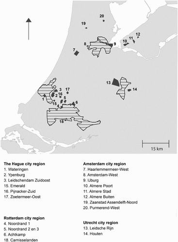
The Fourth Report on Spatial Planning Extra (Vierde Nota Ruimtelijke Ordening Extra, VINEX) (Ministerie van VROM, Citation1990) chose large-scale building sites close to the central cities, such as Leidsche Rijn (near Utrecht), Wateringseveld, Ypenburg and Leidschenveen (near The Hague) Almere and IJburg (near Amsterdam) and the Kop van Zuid and Carnisselande (within and near the city of Rotterdam) (Priemus, Kreukels, & Spaans, Citation1997) (see ). Commercial development companies, real estate investors and (to a lesser extent) housing associations were given the lead in these developments (Priemus, Citation1997). The housing density was modest: 30–35 dwellings per hectare. Eventually, in the new VINEX locations 80% single-family homes and 80% owner-occupied housing were realized. The new housing sites were built in the period 1995–2005. The connection of VINEX locations with public transport networks again lagged behind the housing production. As a result, VINEX locations made a major contribution to traffic jams, parking problems and congestion.
Figure 2. VINEX development areas in the Randstad Holland. Source: Kruythoff and Teule (Citation1997, p. 115).
The Green Heart was, and remained, an icon of environmental policy, but could nevertheless not remain unaffected. Many housing units and industrial areas were built, and the boundaries of the Green Heart were shifted to allow the development of Zoetermeer, more housing on the outskirts of Alphen aan den Rijn along the river Oude Rijn, the expansion of Leiden to the North and the development of Amstelveen. The Green Heart policy was mainly a defensive policy in which the Green Heart area lost ground.
4. Infrastructure determining spatial structure Randstad, before and after 1990
Since the 1920s, when the sale and the use of cars exploded infrastructure development has increased spectacularly. Highway roads, mainports, the national railway network, urban rail and bus lines grew quickly, in particular in the 1960s and the 1970s. But before 1990, infrastructure development and spatial planning were not integrated in a convincing way. It became clear even before the turn of the century that the priority for spatial structuring in the Randstad would be the development of infrastructure rather than large-scale housing concentrations
4.1. Amsterdam-Schiphol and Rotterdam-Europoort
Initially, the mainports of Amsterdam-Schiphol and Rotterdam-Europoort grew fast.
For Schiphol accessibility over land became the focus, whereas in Rotterdam municipal and national government focused on connections with the hinterland. A crucial step was to widen the main motorways (A15, A16) between Rotterdam and the borders with Germany and Belgium.
4.2. New highway cross-river connections
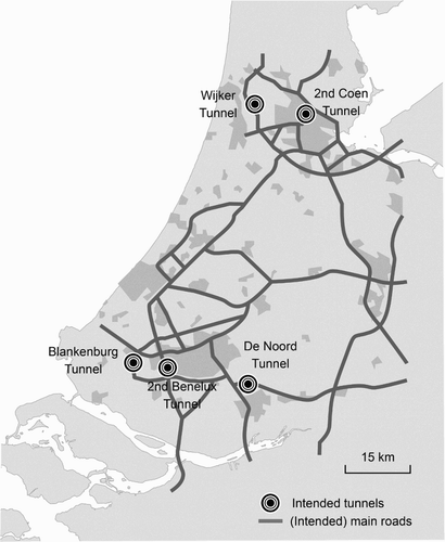
As a result of the increasing car use in the Randstad, there was ever increasing congestion during the morning and evening rush hours. The increase in the capacity of the motorways was not enough to alleviate this congestion. There were persistent problems at places where motorways penetrated urban centres. And, there were increasing problems at the intersection points where the motorway network crossed some large waterways in the Randstad. The cross-river connections at the Nieuwe Waterweg near Rotterdam and the North-Sea Canal near Amsterdam were the most serious traffic bottlenecks (Priemus & Nijkamp, Citation1992; Priemus & Visser, Citation1995). In order to solve this problem, five new tunnels were planned (see ). In the meantime, one of the tunnels, east of Rotterdam, came to fruition. The tunnel projects are mentioned in the Tweede Structuurschema Verkeer en Vervoer (Ministerie van Verkeer en Waterstaat, Citation1990). The five new cross-river connections were all initially privately financed. This was decided on the basis of the Accessibility Scheme for the Randstad (Projectgroep Bereikbaarheidsplan voor de Randstad, Citation1988). A large number of projects – including the tunnels – were proposed to keep the Randstad accessible. Public funds were insufficient to finance all the projects. Private funding for the new cross-river connections was chosen. Expectations were that through private funding the new cross-river connections could be realized more quickly avoiding debudgeting or negative effects on the governmental financing deficit.
Figure 3. Five tunnels, proposed by the Ministry of Transport (1988). Source: Priemus and Visser (Citation1995).
The idea was that the private investments could be recovered by introducing a user contribution scheme of toll collection. At first shadow, tolls were used with the government paying a fixed rate to the tunnel operator for each passage. The government then passed this on to the consumer through a levy in order to prevent the Treasury being involved. Toll collection was adopted only for some new tunnels. The government, with its restrictive policy on car use, preferred a road pricing system for the entire Randstad, but later on this idea was abandoned. The various tunnel projects encountered much resistance. The environmental movements expected environmental damage and were afraid that the realization of the tunnels would result in more car use.
4.3. The bicycle
The modal split in the Randstad is only for a small part determined by the quality of public transport. The Randstad has more in common with suburban areas in the U.S. than concentrated cities such as Hong Kong or Singapore. The large difference in the modal split between the Randstad and polycentric urban areas in the U.S. can be explained by the relatively high share of the bicycle in both commuting and recreational traffic in the Randstad. This share can be ascribed to the absence of mountains and hills, the moderate climate, the outstanding infrastructure for bicycles, a century-old tradition of cycling and the relatively short distances between housing centres in the Randstad (Clark & Kuijpers-Linde, Citation1994). The bicycle culture in the Netherlands has recently received a boost from growth in the sale of racing and electric bikes.
4.4. Mainports
A decision was made to add another runway (the so-called Polderbaan) to the existing system of runways at Schiphol airport. The conflict between economic growth and increasing mobility on the one hand and damage to the environment (CO2 emissions, noise pollution and lack of safety) on the other hand led to the establishment of a permanent institution to consider these conflicts: the so-called Alders-table.
The port of Rotterdam was also further developed and with the development of the Second Maasvlakte. Building a dedicated freight rail line to provide a high-quality rail connection for Rotterdam with the Rhine-Ruhr Area and beyond (the so-called Betuweroute) was also planned. Many years went by before the rail network within the Rhine-Ruhr Area was modernized to the extent that accessibility to the most important centres beyond this area was also of a high quality. The building of both the Betuweroute and the HSL-Zuid (High-Speed Line – South) cost billions of Euros, provided by the Fund for Economic Structural Improvement, financed by the proceeds from gas extracted in the North of the Netherlands and in the North Sea.
4.5. Rail 21
The Tweede Structuurschema Verkeer en Vervoer (Second Structural Scheme for Traffic and Transport, Ministerie van Verkeer en Waterstaat, Citation1990) stated that the growth of the car had to be reined in and secondly that an enormous investment in modernizing the aged rail infrastructure was necessary. The government wanted to invest 700 million Dutch Guilders (about €330 million in 1990) per year in the rail infrastructure in an attempt to accelerate the realization of Rail 21, the Dutch Railways plan (NS, Citation1988).
4.6. High-speed line south
The European High-speed Rail network was developed as an alternative to continental flights over short distances. Schiphol was connected to this network via the HSL-Zuid (HSL-South) (Amsterdam, Schiphol, Rotterdam, Brussels, Paris). The decision process and choice of route for the HSL-South have been widely documented.
Prime Minister Wim Kok proposed an underground track through the fields of the Green Heart: a compromise between the fastest track (a matter of minutes) and preserving the Green Heart (TCI, Citation2004).
With hindsight it was concluded by the Parliamentary Commission on Infrastructure Projects (TCI) that the so-called Bos-option (Bos-variant), proposed by Willem Bos, a citizen of Zoetermeer, was superior to the option preferred by national government. The Bos-option included an HSL-track which ran parallel to the A13 and A4 motorways and did not destroy the Green Heart. The preferred option was based on attaining a speed of 300 km h−1, which was never reached.
When the HSL-South track was finally finished, there were no trains to use the track because Ansaldo Breda, the Italian train producer, could not deliver the high-speed trains in time. Later, there were so many shortcomings that both the Belgian and Dutch governments refused to accept the trains. A financial settlement was reached in 2014 between the train producer and the governments of Belgium and the Netherlands, but the Dutch government did not have an alternative strategy. As a result, the fast track is at this time hardly used.
Over the last decades, the Randstad has become better connected internationally, with a high-speed train on the existing railway tracks to Germany (ICE) and a new dedicated high-speed line South connecting Amsterdam and Rotterdam with Belgium, France and, via Eurostar (transfer: Lille), with the UK. In the meantime, the capacity of the main roads, connecting the Randstad with neighbouring countries, has also increased for both cars and trucks. Plans for a high-speed train or Maglev train connecting Amsterdam, Utrecht, Rotterdam and The Hague (‘Rondje Randstad’) have been proposed several times (supported strongly by Siemens) but never accepted.
4.7. Betuweroute and freight transport
The Randstad infrastructure network is first and foremost developed to meet the mobility needs of people, although goods transport plays an increasingly important role. Highways are used by both cars and trucks. The A15 and A16 from and to Rotterdam and Europoort are used mostly by trucks. De Betuweroute is a dedicated freight rail track across the Provinces of South Holland and Gelderland. Beyond the shunting area of Barendrecht the line transports freight to and from the Rhein-Ruhr Area. The river Rhine plays an increasing role in the transport of freight (bulk and containers) between Rotterdam and Dordrecht in the Netherlands, Dortmund in Germany and beyond. More and more producers, such as Heineken in Zoeterwoude, use ships for transporting their resources and products. A network of pipes also provides an invisible freight function connecting Schiphol and Rotterdam-The Hague Airports with Pernis where kerosene is supplied.
The greenports in the Randstad (Bollenstreek, Aalsmeer, Westland and Boskoop) are also important nodes of freight transport. They are very well connected with Amsterdam-Schiphol, the Rotterdam Harbour Area and the network of main highways. The intertwining of urban housing areas and freight transport lines in the Randstad is a problem, causing high concentrations of particulate matter, greenhouse gas emissions as well as noise in some urban housing environments, mainly in Rotterdam and Amsterdam. This was a reason for the Minister of Transport, who increased speed limits in 2010 throughout the Netherlands to 130 km h−1, to reduce the speed limit of the A13 in Rotterdam-Overschie and the A10 in Amsterdam-West recently from 100 to 80 km h−1.
4.8. Stedenbaan
For more than a decade, the Province of South Holland has adopted the so-called Stedenbaan-approach, which promotes Transit-Oriented Development (TOD) along the ‘old rail track’ between Amsterdam, The Hague, Rotterdam and Dordrecht (Zuidvleugel, Citation2013).
For each railway station area, proposals were formulated to intensify and diversify the functionalilty of the station area: more housing, offices, hotel accommodation, meeting places, shops, bus stations, parking areas for cars and bicycles and improving the quality of the public space (Spaans et al., Citation2004). This is seen as a strategy to increase both the place value and the node value of station areas, by boosting the number of passengers in the train and by improving the urban quality (Bertolini, Citation1996).
The number of passengers entering, leaving or changing trains in each station is increasing each year by 5% in the Randstad and 2.5% elsewhere. The idea is that the frequency of trains on the main lines will be able to increase (e.g. to 1 train per 10 minutes) which will make it possible to travel ‘timetable-free’.
4.9. Light rail
The urban corridor approach also includes the development of metro and light rail networks, such as the RandstadRail, that integrates the tram network in The Hague with the metro system in Rotterdam. RandstadRail connects a number of VINEX locations with the central cities as well as stations on the existing railways, thereby playing an important role in the synergy between infrastructure and urban patterns. A light rail connection in the Northern part of the Randstad (Amsterdam – Utrecht) – Randstadspoor – was developed earlier.
4.10. Towards network cities
Since the turn of the century, infrastructure policy has increasingly determined the spatial development of the Randstad. The dominance of housing policy and new housing locations is losing ground. Since 2008, when the financial-economic crisis struck the real estate market, the production of housing, offices and shops has decreased considerably. Since 2013, the construction market recovered as a result of the improving national economy and low long-term interest rates. The super-position of central cities, VINEX locations, growth poles, smaller cities and traffic infrastructure connections is increasingly creating a pattern of network cities in which infrastructure lines, nodes and built-up areas are better connected (Ministerie van VROM, Citation2008).
4.11. Agglomeration effects
The synergy between infrastructure and buildings is not just a technical design issue, but also an economically relevant approach (ter Weel, van der Horst, & Gelauff, Citationn.d.). Each urban area has both positive and negative agglomeration effects (Priemus, Citation2011). Negative effects include congestion, emissions of greenhouse gas and particulate matter, noise and vibration. Positive effects include reducing the travel time between origin and destination leading to a better spatial integration of housing markets and labour markets. When the connections within a polycentric urban region are improved such a region will increasingly function as a big city, thus providing opportunities for economic and cultural participation of the highest quality. Within polycentric urban regions, ‘borrowed size’ occurs (Meijers, Citation2007), which means that the medium size cities together in an urban network are able to sustain high-quality and large-scale provisions (theatre, sport centre, top musea) comparable with a large metropolis. One of the strategies to increase the positive agglomeration effects is promoting multimodality for both passenger and freight.
4.12. City branding
The improvement of network quality was associated with an ongoing commitment to better profiling for each city. For example, The Hague manifests itself increasingly as the City of Peace and Justice, with an international profile (Meijers, Hoogerbrugge, Louw, Priemus, & Spaans, Citation2014). Rotterdam is developing into a global logistical centre with high architectural qualities at the intersection of sea connections, waterways, road and rail. Better connections between Westland and Europoort are characterized by plans for the Blankenburgh Tunnel, not only to promote the export of horticultural products, but also to increase the recycling of energy in Westland. Amsterdam itself is seen more and more as a financial centre, an ICT hub and a cultural and knowledge city with the Rijksmuseum, the Van Gogh Museum, the Anne Frank House, the City Museum and two universities. Utrecht, also a recognized university city, benefits from its central location in the country, a hub for road and rail and is popular as a place for meetings and conferences. Improving the road and rail (heavy and light) connections between the Rotterdam region and the region around The Hague means that the South Wing is developing into the Metropolitan Region Rotterdam-The Hague, with the knowledge city of Delft at the centre. Rotterdam Airport Zestienhoven has also been given a new name: Rotterdam-The Hague Airport, after the closure of Ypenburg Airport, situated close to The Hague.
5. Water determining spatial structure Randstad, before and after 1990
5.1. Water as an amenity
Within metropolitan areas, water has a strong impact on urban form (Priemus & Rietveld, Citation2009). In Rotterdam in particular, port activities have moved towards the sea coast, creating space for new residential, commercial and recreational activities in central parts of the city. There are strong indications that the water-side orientation of these new locations, sometimes linked with the heritage aspects of port buildings and infrastructures, adds to their attractiveness. The case of port-related heritage making cities attractive for high-income residents is a good example of what Glaeser, Kolko, and Saiz (Citation2001) coined the ‘consumer city’: port heritage and waterfronts add to the amenities of a city. Thus, apart from the classical transport-related functions, such cities are increasingly attractive to residents and visitors. Water is a basic layer for the green types of land use in cities such as parks and ponds.
5.2. Water-related threats
Water has however always been a threat and the orientation of cities close to water is not without its costs. The South Western part of the Netherlands, in particular the Province of Zeeland, was flooded in 1953, and about 1800 people lost their lives. This led to the start of the first Deltaplan, which aimed to make this part of the country resilient to water threats from the sea and the rivers. In many parts of the world, delta areas have experienced floods, such as New Orleans in the U.S., Haiti and the Philippines. Both old and new port cities are preparing, or have already taken measures, to improve their safety, from the sea side, the river side, or both. London is a famous example with its Thames Barrier which has become a tourist attraction. In a similar way, the port of Rotterdam is preventing seawater damaging the city.
As a result of rising sea levels, salination is another risk that may affect cities and agriculture (de Groot et al., Citation2006). Marine transport has also been identified as a major polluter, not only in its day-to-day activities, but also as a result of incidents. This pollution may affect port cities in particular.
Low water levels in rivers may have a negative impact on cities, for example for those depending on electricity and power plants located near rivers whose cooling capacity may be reduced. Also, inland water transport is negatively affected when water levels in navigable rivers are low, because low water results in smaller loads and higher costs per ton. Low water levels may also have negative impacts on the supply of fresh water.
5.3. Dyke Ring 14
As the Randstad lies below sea level and to a large extent coincides with Dyke Ring 14 (), a breach in the dyke could lead to almost the whole Randstad flooding. Although the dykes are in theory strong and high enough, it is an undesirable concentration of risks.
Figure 4. Dyke Ring 14: Central Holland. Source: Priemus (Citation2010).
Dyke Ring 14 (‘Central Holland’) is a crucial piece of engineering and essential for the Randstad (Ministerie van Verkeer en Waterstaat, Citation2007b). It is built around one water system, encompassing Amsterdam-South, Rotterdam, The Hague, Amsterdam Airport and Rotterdam Harbour, and the highways A4, A13, A16, A9, A10, A12, A20 and A15. Dyke Ring 14 extends across three provinces (South Holland, parts of North Holland and Utrecht) and includes the territories of five water boards.
Aerts et al. (Citation2007) estimated the overall economic damage of flooding for the dyke rings to be €190 billion. In 2040, if no measures are taken, a rise of 24–60 centimetres in the sea level will push up the potential direct and indirect damage to €400–800 billion. Again, if no measures are taken, a rise of 150 centimetres by 2100 will result in potential damage of at least €3700 billion (Delta Commissie, Citation2008, p. 22).
5.4. Delta Programme
As a result of the expectations regarding the rising sea levels and the larger fluctuations in the throughput of rivers such as the Rhine, Maas and Scheldt (PBL, Citation2009), there has been renewed interest in the Netherlands since the turn of the century for safety behind the dunes and in the delta. A Delta Commissioner, a Delta Fund and a (second) Delta Programme were introduced (Priemus, Citation2010). The Delta Programme, which is reviewed annually, has various, connected components: raising the height of the dykes, consensus regarding safety norms (‘multi-level safety’), increasing the ‘resilience’ of the river deltas by creating retention areas for temporary surpluses of water (the programme Ruimte voor de Rivier, Space for the River), strengthening of sea defences, reductions in salination and the securing of the fresh water supplies.
The idea of the report of the Delta Commission (Citation2008) was to look into ways of safeguarding the Dutch coast and hinterland in the long term and to propose recommendations for protecting the country from the negative effects of climate change (Kabat, van Vierssen, Veraart, Vellinga, & Aerts, Citation2005; Stern, Citation2007). The question is: how could the Netherlands be made climate-resilient in the long term and in such a way that it would be protected against flooding and continue to be a pleasant place to live, work and relax, while also being a viable investment option?
The recommendations argue that the safety level should be raised considerably. The recommendations also point out that developments need to be implemented at the same pace as climate change and other ecological processes. The Commission considers its recommendations cost-effective and flexible, to be introduced in an adaptive process. Measures can be implemented in the short term and will enable the Netherlands to deal more effectively with the impact of climate change. Safety and sustainability are the twin goals of the strategy for the coming centuries.
The financial dimension (Delta Fund) and administrative details of the Delta Programme have been established in a new Delta Act. The Delta Programme has been set up to implement the recommendations of the Delta Commission. Its report is based on the findings of the IPCC (Citation2007) and Dutch experts in water safety and management. The Netherlands needs to be prepared for a rise in sea level of 0.65–1.30 metres by 2100 and 2–4 metres by 2200. These calculations also take the effects of soil subsidence into account.
Rises in temperature and changes in air circulation are lowering the flow velocity in the Rhine and the Maas in the summer and are increasing it in the winter (van Goor, Zitman, Wang, & Stive, Citation2003). The predicted maximum flow velocity for the Rhine in 2100 is 18,000 m3/s. For the Maas, it is approximately 4600 m3/s (the present normative flow velocities are 16,000 m3/s and 3800 m3/s respectively).
Rising sea levels, lower flow velocities in the summer, longer periods of drought and the insinuation of salt water into rivers and groundwater are threatening fresh water supplies and could have a deleterious effect on drinking water, agriculture, shipping and water-dependent industries – including power stations, which cannot operate without enough cooling water.
5.5. Costs
It will cost €1.2–1.6 billion a year until 2050 and €0.9–1.5 billion a year between 2050 and 2100 to implement the Delta Programme. One of the water safety recommendations in the Delta Programme is to deposit sand on the coast. Implementing ‘sand supplementation’ to broaden the coastal areas of the provinces of ‘Holland’ and ‘Zeeland’ by one kilometre, thereby creating space for recreational areas and countryside, will need an extra €0.1–0.3 billion every year.
5.6. Recommendations for the future
The Delta Commission has formulated many recommendations for the short- and mid-term. Some of these recommendations are summarized below.
The present ‘safety levels’ for all dyke rings need to be improved by a factor of ten. These standards were established in 2013.
The choice of whether or not to develop new housing in physically unfavourable locations should be based on a cost–benefit analysis, which should include calculations of all current and future costs. Costs resulting from local decisions should not be passed on to another tier of government or to society as a whole, but should be borne by those who stand to profit from them.
Building in tune with the natural environment: the ‘coasts’ of ‘Zeeland, Holland and the Wadden’ Islands will be made safe by sand supplementation (Ministerie van Verkeer en Waterstaat, Citation2007a). This may require the repositioning of tidal channels. Supplementation should be carried out in such a way that it is possible for the coast to become broader in the future. Adding large volumes of extra sand helps to make the process efficient in terms of ecology, economy and energy.
The Krammer-Volkerak-Zoommeer lakes, the Grevelingen lake, and possibly the Eastern Scheldt should be made suitable for storing temporary surplus water from the Rhine and the Meuse.
The programme Ruimte voor de Rivier (Space for the River) (Ministerie van Verkeer en Waterstaat, Citation2006) needs to be implemented quickly. In places where it is cost-effective to do so, measures should be taken immediately to achieve higher discharge volumes for the Rhine and the Meuse. This will involve liaising with neighbouring countries in line with the ‘EU Directive on the Assessment and Management of Flood Risks’.
5.7. Flood-risk-zoning
Pieterse, Knoop, Nabielek, Pols, and Tennekes (Citation2009) have proposed the use of flood-risk-zoning to differentiate between areas with different flood risks. Flood-risk-zoning would enhance the policy on flood safety and sustainable urban planning by subjecting vulnerable areas to specific planning procedures. This would not reduce the possibility of flooding but it would prevent or contain the damage.
Flood-risk-zoning explicitly defines the implications of spatial planning decisions for future safety. At this stage, informative and procedural measures will suffice (RPB, Citation2007). Safety can also be directly enhanced by introducing concrete regulations for the planning of ‘vital’ objects such as hospitals and power stations. Finally, risk-zoning can influence the results of the planning process in such a way that areas can be made safer in the longer term. This requires huge investments.
6. Compartmentalization of Dyke Ring 14
The project to compartmentalize the ‘Central Holland’ area is proposal number 32 on the Randstad High-Priority Programme (Urgentieprogramma Randstad). The proposed project is described in this programme as follows (Ministerie van Verkeer en Waterstaat, Citation2007c, p. 46); in translation:
The Randstad consists of one single dyke ring (the ‘Central Holland’ dyke ring). There is only a limited risk of flooding from rivers or the sea, but if such flooding were to occur, the damage must be contained as much as possible. Compartmentalisation (the practice of installing ‘partitions’) is one way of ensuring that any flooding is contained. This project should establish which areas of the Randstad could benefit from compartmentalisation by making use of existing areas of raised land in the landscape (alluvial ridges or rail and road embankments) or by constructing new dykes within the dyke ring. Compartmentalisation would involve a number of municipalities, water boards and provinces, and must therefore take account of a range of spatial interests.
Model-based calculations have indicated that, even under the most extreme circumstances, the entire area inside the dyke ring would not be flooded. There is a natural barrier along the Old Rhine, on the Leiden-Utrecht line, which prevents water from flowing from north to south and vice versa. However, the consequences would still be catastrophic even if only a part of this area were to become flooded; no other part of the Netherlands is as densely populated or as economically important as the Randstad (de Bruine & Hesselink, Citation2007, p. 51).
There is every reason not only to raise the dykes to reduce the risk of flooding, but also to further compartmentalize the dyke rings in the Dutch delta into a number of dyke rings with smaller surface areas. In addition, the larger cities, the hubs of economic and cultural value, could be more tightly enclosed and better protected. The idea of compartmentalization is not new. Experience with compartmentalized oil tankers has shown them to be less vulnerable.
Extra dykes should, ideally, coincide with strategic road and rail connections so that, in the unfortunate event of a flood or a flood threat, vital infrastructural connections remain intact. The ring roads around Amsterdam, Utrecht, Rotterdam and partly around The Hague should be raised in such a way as to form separate dyke rings for these cities. In this way, the human, economic and cultural capital of these cities is better protected against flooding.
Raising and strengthening the international connections (HSL-South, HSL-East, highways A4, A13, A16, A15, A20, A1, A2, A12) will make them more resilient to flooding (). The Randstad will be divided into a number of dyke rings, each with a smaller surface area (see ). In addition, building a dyke would also protect Schiphol airport from flooding, as it is also situated below sea level.
Figure 5. Randstad Holland: compartmentalization with elevated infrastructures around and between cities. Source: Priemus (Citation2010).
de Bruine and Hesselink (Citation2007) used model research to look into the possibilities of further compartmentalizing the area of Dyke Ring 14. The following strategy is derived from their study.
The area is split into smaller compartments by the construction of dykes. Maximum use is made of existing dykes and other elevated parts of the landscape, such as railways, roads and sleeper dykes. It should be noted, however, that it is uncertain whether all these elevations in the landscape could withstand the water pressure. Roads and railways were not designed to retain water, and old dykes have not been tested for a very long time. They are also intersected by tunnels and viaducts – gaps that could not be permanently closed without involving enormous costs; this could mean, for example, the removal of tunnels. Emergency locks could be installed to close these gaps temporarily, but it is uncertain whether these could be put into action quickly enough in the event of flooding. The number of casualties and the extent of flood damage can be estimated. The speed at which the water will rise is crucial because people can easily be caught off guard by rising water levels and run the risk of drowning if they do not have enough time to reach a safe place inside the area (de Bruine & Hesselink, Citation2007, p. 52).
6.1. Compartmentalization: towards better integration the Delta Programme, spatial planning and infrastructure policy
Since 2008, the year the Delta Programme was published, dealing with water problems has increasingly determined the spatial structure of the Randstad. In the future, more synergy between the Delta Programme, spatial planning and infrastructure planning is necessary (as in ‘Space for the River’). The phased realization of the compartmentalization of Dyke Ring 14 could be a promising strategy to strengthen this synergy.
In a compartmentalization strategy, the dimensions of the compartments are crucial. If the compartments are too large, compartmentalization will have a little effect. If they are too small, the flood water will rise too fast. People in densely populated areas will be taken by surprise and may drown. Various combinations of dimensions were tested in the study by de Bruine and Hesselink (Citation2007). One outcome is that a compartment of around 10 km2 would be the hydraulic optimum for a large flood in the area of Dyke Ring 14. However, such small compartments could lead to a strong landscape fragmentation. We consider this to be a minimum size and propose a larger average size.
Special attention should be paid to certain factors in the realization of the compartmentalization strategy:
The time it takes for a compartment to fill in the event of a breach in the dyke.
The vulnerability of underground systems and tunnels.
The effects of complex junctions where roads intersect at different heights. The lower roads are particularly vulnerable. More redundancy could be introduced to these junctions in such a way that all the vital connections remain operational via elevated roads.
So far, the general risk of flooding is seen as acceptable and there have been no consequences for the value of properties or the level of insurance premiums. Nevertheless, the feeling remains that it is important to keep ahead of a possible breach in the trust by ensuring that measures are taken in time.
7. Closing remarks
In this paper, we have argued that the spatial structure of the Randstad before and after 1990 has been determined successively by housing and infrastructure policy and that now water issues are becoming more important. Since about 2000, national government has broken with the tradition of Dutch publicy-oriented land-use planning. A reassessment of national spatial planning is recommended. In the coming years, it is important to integrate housing, infrastructure policy and water policy better, with spatial policy playing an integrating role.
The compartmentalization of Dyke Ring 14 is a fine example of a strategy where different policy areas come together. The result highlights the role of the network city and urban networks in the planning doctrine for future decades. ICT and energy infrastructures also play an important role. Such a strategy must fit into a greater strategy which exploits the economic potential of the Randstad as much as possible (Priemus, Citation1994). This requires a combination of competition and collaboration in both national and international networks. For many urban delta areas worldwide, the planning experience in the Randstad could be useful. This will be increasingly a domain of cross-learning between various planning systems in Europe and beyond. In urban deltas rising sea levels play an increasing role in spatial planning an exchange of knowledge, and experience is particularly crucial.
Within the NW-part of Europe, competition between cities will be combined more and more with forms of selective collaboration: such as the airports of Amsterdam-Schiphol, Paris Charles de Gaulle and Rotterdam-The Hague airport, and the ports of Rotterdam, Antwerp and Amsterdam. There is also increasing interest in building relations with the Rhein-Ruhr Area and the Flemish Diamond (Dieleman & Priemus, Citation1996). The focus on internal accessibility within the Randstad is increasingly complemented by the focus on external accessibility.
The economic dynamics of the Randstad can be seen as the continuation of the traditional Dutch orientation towards international trade, as well as scientific excellence, application, creativity, knowledge and innovation.
Acknowledgments
The author thanks three anonymous referees for their helpful comments and suggestions, and a native speaker, for her editorial work.
Disclosure statement
No potential conflict of interest was reported by the author.
References
- Aerts, J., Kolen, B., van der Most, H., van ‘t Klooster, S., Satijn, B., & Leusink, A. (2007). Waterveiligheid en klimaatbestendigheid in breder perspectief [ Water safety and climate resilience in a broader perspective].
- Berry, B. J. L. (1964). Cities as systems within systems of cities. Papers in Regional Science, 13, 147–163. doi: 10.1111/j.1435-5597.1964.tb01283.x
- Bertolini, L. (1996). Nodes and places: Complexities of railway station redevelopment. European Planning Studies, 4(3), 331–345. doi: 10.1080/09654319608720349
- Carruthers, J. I. (2002). The impacts of state growth management programmes: A comparative analysis. Urban Studies, 39(11), 1959–1982. doi: 10.1080/0042098022000011317
- Castells, M. (1989). The informational city: Information technology, economic restructuring and the urban-regional process. Cambridge, MA: Basil Blackwell.
- Clark, W. A. V., & Kuijpers-Linde, M. (1994). Commuting in restructuring urban regions. Urban Studies, 31(3), 465–483. doi: 10.1080/00420989420080431
- de Bruine, E., & Hesselink, A. (2007). Kansen voor compartimentering in de Randstad [Compartmentalisation opportunities in the Randstad]. Tijdschrift voor watervoorziening en afvalwater, 40(25/26), 51–53.
- de Groot, R. S., van Ierland, E. C., Kuikman, P. J., Nillesen, E. E. M., Platteeuw, M., Tassone, V. C., … Verzandvoort-van Dijck, S. (2006). Climate adaptation in the Netherlands. Bilthoven: RIVM: Netherlands Environmental Assessment Agency.
- Delta Commissie. (2008, September). Samen werken met water. Een land dat leeft, bouwt aan zijn toekomst [Working with water. A country that lives, builds for its future]. The Hague: Author.
- Dieleman, F. M., Dijst, M. J., & Spit, T. (1999). Planning the compact city: The Randstad Holland experience. European Planning Studies, 7(5), 605–621. doi: 10.1080/09654319908720541
- Dieleman, F. M., & Priemus, H. (Eds.). (1996). De inrichting van stedelijke regio‘s. Randstad-Noord-Brabantse Stedenrij-Ruhrgebied [ Spatial planning of urban regions. Randstad – North-Brabant urban corridor – Ruhr Area]. Assen: Van Gorcum.
- Faludi, A., & van der Valk, A. (1990). De groeikernen als hoeksteen van de Nederlandse ruimtelijke planningdoctrine [ Growth centers as cornerstone of Dutch physical planning doctrine]. Amsterdam: University of Amsterdam.
- Garreau, J. (1991). Edge city. Life on the new frontier. New York, NY: Doubleday.
- Glaeser, E. L., Kolko, J., & Saiz, A. (2001). Consumer city. Journal of Economic Geography, 1, 27–50. doi: 10.1093/jeg/1.1.27
- Graham, S., & Marvin, S. (1996). Telecommunications and the city: Electronic spaces, urban places. London: Routledge.
- Hall, P. (1998). Cities in civilization: Culture, innovation and urban order. London: Phoenix Giant.
- Heerma, E. (1989). Nota Volkshuisvesting in de Jaren Negentig [ Housing in the Nineties Memorandum]. The Hague: Ministerie van VROM.
- Kabat, P., van Vierssen, W., Veraart, J., Vellinga, P., & Aerts, J. (2005). Climate proofing the Netherlands. Nature, 438, 283–284. doi: 10.1038/438283a
- Kruythoff, H., & Teule, R. (1997). VINEX policy moves into the implementation phase. Netherlands Journal of Housing and the Built Environment, 12(1), 113–133. doi: 10.1007/BF02502626
- Meijers, E. (2007). Synergy in polycentric urban regions: Complementarity, organising capacity and critical mass. Delft: Delft University Press.
- Meijers, E., Hoogerbrugge, M., Louw, E., Priemus, H., & Spaans, M. (2014). City profile: The Hague (the Netherlands). Cities, 41, 92–100. Published online: June 27, 2014. doi: 10.1016/j.cities.2014.05.012
- Ministerie van Verkeer en Waterstaat. (1990). Tweede Structuurschema Verkeer en Vervoer. Deel d: Regeringsbeslissing [Second structure outline plan traffic and transport. Part d: Government’s decision]. The Hague:Sdu Uitgevers.
- Ministerie van Verkeer en Waterstaat. (2006). Ruimte voor de Rivier [Space for the river]. Planologische Kern Beslissing part 4.The Hague: Author.
- Ministerie van Verkeer en Waterstaat. (2007a). Beleidslijn kust [Policy line for the coast]. The Hague: Author.
- Ministerie van Verkeer en Waterstaat. (2007b). Water in de Randstad [Water in the Randstad]. The Hague: Author.
- Ministerie van Verkeer en Waterstaat. (2007c). Urgentieprogramma Randstad: Randstad Urgent [Urgency programme Randstad]. The Hague: Author.
- Ministerie van Volkshuisvesting en Bouwnijverheid. (1966). Tweede Nota over de Ruimtelijke Ordening [Second spatial planning memorandum]. The Hague: Staatsuitgeverij.
- Ministerie van Volkshuisvesting en Ruimtelijke Ordening. (1974). Oriënteringsnota Ruimtelijke Ordening [Orientation memorandum on spatial planning]. The Hague: Staatsuitgeverij.
- Ministerie van Volkshuisvesting en Ruimtelijke Ordening. (1976). Verstedelijkingsnota Ruimtelijke Ordening [Urbanization Memorandum on Spatial Planning]. The Hague: Staatsuitgeverij.
- Ministerie van Volkshuisvesting en Ruimtelijke Ordening. (1983/1985). Structuurschets Stedelijke Gebieden [Structure outline urban areas]. The Hague: Staatsuitgeverij.
- Ministerie van Volkshuisvesting, Ruimtelijke Ordening en Milieubeheer (VROM). (1988). Vierde Nota over de Ruimtelijke Ordening. Deel a: beleidsvoornemens [Fourth report on spatial planning. Part a: Policy intentions]. The Hague: Sdu Uitgevers.
- Ministerie van Volkshuisvesting, Ruimtelijke Ordening en Milieubeheer (VROM). (1990). Vierde Nota over de Ruimtelijke Ordening Extra (VINEX) [Fourth report on spatial planning extra]. The Hague: Sdu Uitgevers.
- Ministerie van Volkshuisvesting, Ruimtelijke Ordening en Milieubeheer (VROM). (2008). Structuurvisie Randstad 2040 [Randstad structural vision 2040]. The Hague: Author.
- Nederlandse Spoorwegen (NS). (1988). Rail 21. Utrecht: Author.
- IPCC, Parry, M., Canziano, O., Palutikof, J., van der Linden, P., & Hanson, C. (Eds.). (2007). Climate change 2007 - Impacts, adaptation and vulnerability; Contribution of Working Group II to the Fourth Assessment report of the IPCC. Cambridge: Cambridge University Press.
- Pieterse, N., Knoop, J., Nabielek, K., Pols, L., & Tennekes, J. (2009). Overstromingsrisicozonering in Nederland [ Flooding risk zoning in The Netherlands]. The Hague: Planbureau voor de Leefomgeving.
- Planbureau voor de Leefomgeving (PBL). (2009, April). Wegen naar een klimaatbestendig Nederland [Roads to a climate proof Netherlands]. Bilthoven: Author.
- Priemus, H. (1990, September 24). Naar een herprofilering van de ruimtelijke ordening [Towards a new profile of spatial planning]. Staatscourant, 185(50), 23.
- Priemus, H. (1994). Planning the Randstad: Between economic growth and sustainability. Urban Studies, 31(3), 509–534. doi: 10.1080/00420989420080451
- Priemus, H. (1997). Spatial planning and housing policy: On the ties that bind. Netherlands Journal of Housing and the Built Environment, 12(1), 77–90. doi: 10.1007/BF02502624
- Priemus, H. (2010, November 11–13). Global eco cities: Climate change and flood risk. Paper presented at the Global Eco-Cities Conference, Shenzhen.
- Priemus, H. (2011). Synergy between transport infrastructures and cities – Towards better places. In S. Chisholm (Ed.), Investing in better places: International perspectives (pp. 57–67). London: The Smith Institute.
- Priemus, H., Button, K., & Nijkamp, P. (Eds.). (2007). Land use planning. Series Classics in Planning nr. 6. Cheltenham: Edward Elgar.
- Priemus, H., Kreukels, T., & Spaans, M. (Eds.). (1997). Spatial planning in the Netherlands: Current developments and debates. Netherlands Journal of Housing and the Built Environment, 12(1), 1–163. doi: 10.1007/BF02502619
- Priemus, H., & Nijkamp, P. (1992). Randstad policy on infrastructure and transportation – High ambitions, poor results. In F. Dieleman & S. Musterd (Eds.), The Randstad: A research and policy laboratory (pp. 165–191). Dordrecht: Kluwer.
- Priemus, H., & Rietveld, P. (2009). Climate change, flood risk and spatial planning. Special issue. Built Environment, 35(4), 425–431. doi: 10.2148/benv.35.4.425
- Priemus, H., & Visser, J. (1995). Infrastructure policy in the Randstad Holland: Struggle between accessibility and sustainability. Political Geography, 14(4), 363–377. doi: 10.1016/0962-6298(95)95719-E
- Projectgroep Bereikbaarheidsplan voor de Randstad. (1988). Bereikbaarheidsplan voor de Randstad [Accessibility scheme for the Randstad]. The Hague: Ministerie van Verkeer en Waterstaat.
- Rijksplanologische Dienst. (1986). Ruimtelijke perspectieven [Spatial perspectives]. The Hague: Staatsuitgeverij.
- Ruimtelijk Plan Bureau (RPB). (2007). Overstromingsrisico‘s als ruimtelijke opgave [Flooding risks as a spatial challenge]. The Hague: Author.
- Sassen, S. (1991). The global city. New York, NY: Princeton University Press.
- Spaans, M., Maat, K., Konings, R., Meijers, E., Kersloot, J., & Priemus, H. (2004). Potenties voor wonen nabij knooppunten [ Potentials for housing near nodes]. Hoevelaken: Bouwfonds, TU Delft, Wissing Stedenbouw en Ruimtelijke Vormgeving.
- Stern, N. (2007). The economics of climate change. The Stern review. Cambridge: Cambridge University Press.
- ter Weel, B., van der Horst, A., & Gelauff, G. (n.d.). The Netherlands of 2040. The Hague: CPB.
- Tijdelijke Commissie Infrastructuurprojecten (TCI). (2004, December 15). Reconstructie HSL-Zuid. De besluitvorming uitvergroot [Reconstruction HSL-South. The decision-making process under the looking glass], Tweede Kamer, 2004-2005, 29.283, nr. 8. The Hague, Sdu Uitgevers.
- van Goor, M. A., Zitman, T. J., Wang, Z. B., & Stive, M. J. F. (2003). Impact of sea-level rise on the morphological equilibrium state of tidal inlets. Marine Geology, 202(3/4), 211–227. doi: 10.1016/S0025-3227(03)00262-7
- Vickerman, R. W. (2000). Economic growth effects of transport infrastructure. Jahrbuch für Regionalwissenschaft, 20, 99–115.
- Zonneveld, W. A. M. (1991). Conceptvorming in de ruimtelijke planning: patronen en processen [ Forming of concepts in spatial planning: Patterns and processes]. Amsterdam: Universiteit van Amsterdam.
- Zuidvleugel. (2013). Monitor Stedenbaan Plus 2013. The Hague: Programmabureau Stedenbaan Plus.