
ABSTRACT
The development of urban food policies has shed light on the strategic role of public landownership for strengthening farmers capacities in the context of rising land values. Despite attention on a few pioneering farming initiatives promoted by local authorities on public farmland, however, there is often little understanding of the extent of public landownership and the modus operandi of public institutions within urban land markets. This makes it hard to assess how representative these ‘pioneering’ projects are and whether or not they are embedded in coherent urban agendas. The city region of Ghent (Belgium) offers an exemplary case: internationally celebrated for its innovative urban food policy, its administration is at the centre of controversies with farmers and grassroots movements who denounced the large-scale sell-off of historical public farmland in the city region. Using Belgian Land Registry data, this paper constructs a unique, empirically grounded, cartography of public landownership and public land transaction for the Ghent city region. The results expose deep contradictions in public policy and demonstrate the continuation of an urbanism disconnected from agricultural concerns. They also provide tools for reshaping the management of public land aligned to urban food policy goals, in and beyond the Ghent city region.
Introduction
In the past 10–20 years, there has been a strong and international increase in the attention paid to food issues in urban environments. Alongside countless social practices and a decisive increase in food-related social movements, this has led to several parallel but strongly interrelated developments in the policy, planning and research fields. Planning scholars have transformed the topic of food from being ‘a stranger in the planning field’ (Pothukuchi and Kaufman Citation2000) into the dedicated academic field of sustainable food planning (Cabannes and Marocchino Citation2018; Ilieva Citation2016; Morgan Citation2009, Citation2013; van der Valk and Viljoen Citation2014). Local and regional actors have produced a broad range of food-related vision documents, strategies and policy initiatives (Calori et al. Citation2017; Candel Citation2020). It also led to new urban political arenas, from food councils at city level (Moragues-Faus et al. Citation2013; Sonnino Citation2019) to national and international networks of cities coming together around the urban food agenda (Moragues-Faus Citation2021; Tornaghi and Dehaene Citation2021a). One of the best known examples is the Milan Urban Food Policy Pact (MUFPP): an international agreement among more than 200 cities committed to the development of sustainable food systems.Footnote1
The development of urban food policy, alongside a debate on its ambitions and goals, also involves the search for appropriate policy instruments for its implementation (Candel Citation2020; Moragues-Faus et al. Citation2013). One of the policy instruments of relevance for the development of urban food policies relates to the management of public landownership, i.e. land owned by public institutions and which is or may be important for food production. Ever since its creation in 2015, the MUFPP framework for action recommends cities to ‘provide access to municipal land for local agricultural production’ and to ‘promote integration with land use and city development plans and programmes’ (Milan Urban Food Policy Pact Citation2015). Farming communities and grassroots movements engaged in the development of urban food policies have also raised the issue of public farmland and its potential to increase land access (Access to Land Network Citation2017; Longhurst Citation2019; Miklos et al. Citation2020; Nyéléni Europe and Central Asia Citation2021) otherwise impossible given current speculative land markets (Harvey Citation1985). This has led to a growing number of initiatives of urban food production on public land. Many of them are abundantly documented in best practice inventories (Forster et al. Citation2015; Moragues-Faus et al. Citation2013) and in (comparative) case studies in academic research (Baysse-Lainé, Perrin, and Delfosse Citation2018; Colombo, Grando, and Lepri Citation2021; Jarrige Citation2018; Perrin and Baysse-Lainé Citation2020).
Although public land initiatives are on the urban food policy agenda and the amount of case-related research on the subject is growing, more structural and strategic considerations on the relevance of public landownership for urban food policy development often remain untouched. As a result, three sets of considerations and questions emerge. Firstly, it remains unclear to what extent food growing projects on public land are representative of public land policies as a whole. Precedents in the French context have already led to the conclusion that the deployment of public landownership in urban food policy remains ‘anecdotal’, ‘restricted to its technical and operational aspects’ and thus ‘not part of an explicit political discourse’ (own translation, from Baysse-Lainé, Perrin, and Delfosse Citation2018, 15–16) and that agriculture ‘remains marginal in public land strategies’ (Perrin Citation2017, 24). Secondly, in several Western European countries, the emergence of urban food policy does not structurally seem to alter the ongoing sell-off of historical public (agricultural) patrimony (Artioli Citation2021; Christophers Citation2018; Franco and Borras Citation2013). As Merrifield (Citation2014b) indicates, such sell-off is strongly interrelated with a ‘parasitic mode of urbanization’ that uses urban resources ‘for expanded capital accumulation by dispossession in times of capitalist crises, as new rounds of primitive accumulation in times of public sector austerity’ (Merrifield Citation2014b, 119). For the London metropolitan region, Artioli (Citation2021) demonstrated how the sale of public land is institutionalized as a financing instrument, which hides the political nature of its sell-off and leads to policies that ‘limit the use of public land, overlook alternatives, drive up land values and exacerbate exclusionary effects’ (1). Thirdly, comprehensive, quality information on public landownership seems unavailable to many communities mobilizing around the development of urban food policy for various reasons. This contrasts sharply with international research concluding that data and monitoring are among the key facilitators for the development and implementation of urban food policies (IPES-Food Citation2017; Moragues-Faus and Marceau Citation2019).
Some of the authors of this paper have argued before that ‘isolated land protection projects are insufficient to disrupt the progressive devaluation of soil life and the ongoing land value speculation in urban and peri-urban contexts’ (Tornaghi and Dehaene Citation2020, 7). Their plea for an ‘agroecological urbanism’ explicitly calls for not seeing the city as a container into which food has to be retrofitted, but rather for questioning the current organization of urban society (urbanism) and making localized, ecologically sustainable and socially just food production an integral part of its founding principles (Tornaghi and Dehaene Citation2021b). This ‘urbanism perspective’ comes with the challenges of unpacking and dissecting the economic and spatial processes that currently drive urbanization and constructing alternatives (Tornaghi and Dehaene Citation2021a, 1). Applied to the subject of public landownership for urban food policy development and considering the three sets of considerations discussed above, an urbanism perspective raises questions about to what extent mainstream approaches to public landownership for the development of urban food policy are really contributing to a progressive urban agenda. This fuels our thesis that the mobilization of public land for the development of urban food policy also requires a good understanding of existing public landownership and the current ‘modus operandi’ of public institutions on urban land markets.
In this paper, we critically examine the reality of public landownership and public land transactions in city region of Ghent – a city that is internationally regarded as a pioneer in the development of urban food policy. We empirically ground our work in a comprehensive and detailed georeferenced analysis of public landownership and public land transactions. In the methodological section of the paper we provide a justification of the case selection and clarify how we accessed and made use of original Belgian Land Registry data. In the results section, we first provide a qualitative and comprehensive picture of public landownership in the Ghent city region. Secondly, we present the overall evolution of public landownership and the extent of public land transactions in the period 2010-2020. Thirdly, we dive into the current modus operandi of public institutions on the urban land market and examine the extent to which their land transactions reflect food or agriculture-driven policy objectives. In the discussion section, we come back to the question to what extent the attention for public landownership from the Ghent food policy is contributing to a coherent urban agenda.
Methodology
Case study
Located in the northern part of Belgium (Flanders), the city region of Ghent is an interesting case for assessing the strategic value of public landownership for food policy and to understand the current debates on its use. First of all, Ghent is a clear example of an existing but selective uptake of public landownership for urban food policy development. The city has an urban food policy since 2013 (City of Ghent Citation2016), it was among the first to sign the Milan Urban Food Policy Pact (MUFPP) in 2015 and it has been awarded several (inter)national prizes ever since (UNFCCC Citation2019). In 2017, two urban-oriented agricultural projects were granted access to public land through a call for projects. These consist of a six hectares horticultural project and a grazing project of a few dozen hectares of nature area, both in the territory of Ghent. Both projects are showcased by the city as two main ‘best practices’ illustrative of its urban food policy (Kerselaers et al. Citation2020). At the same time, farmers and grassroots movements in the Ghent city region have been increasingly mobilizing around the potential of public land for developing and strengthening urban food policy. To some extent, this is not surprising in a context of very high and rising farmland prices and very high pressure on farmland from non-agricultural activities (Verhoeve et al. Citation2015). However, the mobilization is also the result of a growing dissatisfaction with the inconsistent way public land is deployed in the Ghent urban policy and its ongoing sell-off.
In order to understand landownership and land sales in Belgium, it is important to understand the historical origins of the patrimony of the so-called Public Centres for Social Welfare (PCSWs hereafter), the municipal geography of these institutions and the ever-increasing institutional amalgamation of PCSWs within their related local municipalities during the last decades. PCSWs are the historical heir to – mostly agricultural – patrimony donated to former charity institutions since the late Middle Ages (Vermaerke Citation1995). Specific to what are now the PCSWs of metropolitan local authorities is that they often obtained land both within and outside the administrative boundaries of their municipality. In the case of Ghent, this concerns thousands of hectares of farmland and farmsteads in the wide city region (De Schryver Citation2000). While this patrimony has been relatively stable for a long time, since the 1970s it started to decrease drastically as PCSWs increasingly began to appreciate the market value, rather than the use value, of their agricultural assets. A recent institutional reform of the PCSWs in Flanders forced a strong integration of the autonomous PCSWs with the local authorities (Vlaamse overheid Citationn.d.). Yet, on paper, PCSWs and local authorities are still two separate institutions with a different legal status. This institutional reform has contributed to making strategic decisions about the management of historical heritage increasingly the subject of political decision-making by local authorities. Similar to what Artioli describes for London (Artioli Citation2021), this has led to the institutionalization of the continued sale of Ghent’s agricultural patrimony as a financing instrument. This involves selling farmland outside the administrative boundary of Ghent to finance investments in social housing and residential care centres within Ghent (Stad Gent Citation2014, Citation2016, Citation2021). In 2020, the PCSW of Ghent owned still 1800 hectares of farmland, 93,3% of which was located outside the city’s administrative boundaries (Stad Gent Citation2021). Farmers and rural movements argue that the large-scale sell-off of this historical agricultural patrimony is in contradiction with the objectives of the urban food policy. Their dissatisfaction is expressed in open criticism of the current scope of Ghent’s food policy and protests against the city’s land policy, as well as an ongoing lawsuit filed by an organic farmer over the sale of 450 hectares of farmland in one single batch to a well-known investor in 2016 (De Boeck and Hiergens Citation2021; Vandermaelen et al. Citation2020).
The over focus on a number of high-profile sale dossiers is also exemplary of the lack of data on public landownership in the Ghent city region. By focusing almost exclusively on imminent sales, the debate is constantly overtaken by events. It pays scant attention to remaining public landownership, overlooks the landownership of public institutions other than the PCSW of Ghent and creates a very incomplete picture of the diverse forms that public land transactions take in the urban land market. This motivated us to look beyond the PCSW of Ghent in our research and to adopt a comprehensive approach.
Empirical data
Prior to our research, there were no accessible, qualitative and complete overviews and maps of public landownership in the Ghent city region. The Belgian Land Registry has detailed information on the property rights of all real estate in the country. For our research, we gained access to raw data from the Belgian Land Registry on the landownership of public institutions based on the principle of open government provided for in the Belgian Constitution. This means that, in principle, any citizen can request this information. However, this does not seem to have happened systematically yet – possibly due to a lack of precedents and because the raw data requires additional processing.
The identification of ownership rights of public institutions was defined by mutual agreement and carried out by the Belgian Land Registry. The resulting selection contained all ownership rights of public institutions on cadastral parcels in the city region of Ghent, with an annual excerpt on 1 January from 2010 until and including 2020. Based on this, we first created a digital map of public landownership for each year individually. In a second step, we compared these annual maps to create a new dataset covering all public land transactions in the period 2010–2020 (losses and acquisitions, including transfers between public institutions). Subsequently, we thematically enriched both the annual files and the database of public land transactions with the Flemish zoning plan (see below). The data processing was carried out with the data integration software FME and subsequently processed into graphs and maps in QGIS and Adobe Illustrator.
The processed data allowed us to study the extent, geography and net evolution of public landownership as well as actual public land transactions in the region. Two additional sources of information were used for the interpretation. To enable a morphological interpretation, we consulted orthoimageryFootnote2 and Google Maps. In order to better understand the modus operandi of various public institutions on the land market, 10 semi-structured interviews were conducted between May 2021 and January 2022 with representatives of the city of Ghent, the provincial and the Flemish government, as well as with an agronomist and two historians familiar with the topic. Interview materials were only used to verify and contextualize the phenomena emerging from the data analysis.
Practical choices and assumptions
Furthermore, the following practical choices and assumptions were made:
- Geographical scope: Our study area corresponds to the boundaries of the province of East Flanders, in which the city of Ghent is located relatively centrally. We deliberately opted for a broad demarcation of the city region in order to cover the regional geography of Ghent’s PCSW patrimony. We are aware of the fact that the PCSW of Ghent owns land outside the region, but we considered an extension of the geographical scope unnecessary as it only involves a relatively small amount of land.
- Delimitation of public landownership: In our research, public landownership is understood as the cadastral parcels of land on which public institutions have ownership rights. Public institutions include the federal government, the Flemish government, the provincial government, local municipalities, PCSWs, the ChurchFootnote3 and a small category of unclassified public institutions.Footnote4 Public institutions legally constituted as cooperative companies with limited liability could not be included in the selection of Land Registry data. This means that a limited group of institutions such as inter-municipal companies and utility infrastructure operators were excluded. Transactions between public institutions were analysed solely at the level of public institution categories mentioned above to prevent a distortion by mergers of municipalities, name changes, etc.
- Zoning category: We chose to categorize public landownership on the basis of the most recent version of the Flemish zoning plan (situation on 1 January 2020), which provides an up-to-date and area-wide overview of all planned land uses.Footnote5 Not every publicly owned parcel has potential for food growing. However, there is no simple and neutral way to determine which plots of land are considered valuable and which are not by means of a few general, technical criteria. Moreover, the above-mentioned sale of public farmland to finance residential public infrastructure illustrated that a broad perspective is necessary for understanding the rationales structuring public land transactions. We gave priority to studying public landownership in areas zoned for agricultural and green purposes, but also referred to other zoning categories when useful. We emphasize that it is by no means our intention to suggest that the strategic use of public land in the context of urban food policy should be limited to public farmland, nor that zoning is the only or the most important instrument for shaping this policy domain.
- Terminology: Public land transactions were divided into acquisitions and losses. We deliberately did not use the terms purchases and sales because public land can also be acquired or lost in other ways (e.g. donations, public ownership rights with an expiry date, etc.). Furthermore, all percentages in this paper are based on land areas, never on numbers of plots.
Results
1. Overview of existing public landownership
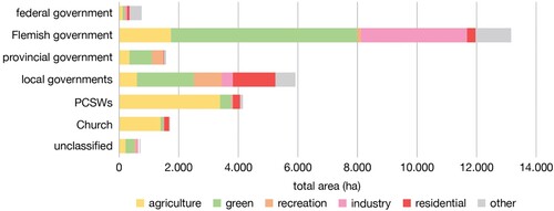
On 1 January 2020, public institutions had ownership rights on a total area of 27.977 ha in the Ghent city region, equalling a share of 10,1% of the total area.Footnote6 This public landownership was distributed among different public institutions (). The landownership of the Flemish government clearly appeared to be the largest. This was followed by local governments and PCSWs. Looking at agricultural land, the largest quantities were observed among PCSWs, the Church and the Flemish government. The share of farmland compared to other planned land uses was particularly high for the first two. Green areas constituted a very important part of land owned by the Flemish government and local governments. The large share of industrial land owned by the Flemish government resulted from two major port areas (Ghent and Antwerp) within the study area. Residential areas had an important position in the landownership of local governments and are also found among PCSWs, the Church and the Flemish government. Public recreational areas were mainly owned by local and provincial governments. The category ‘other’ included a whole range of special areas such as hospitals, landfill sites and military infrastructure, with negligible relevance to this research. Of all public land, about two-thirds was classified as agricultural or green areas and therefore of particular interest for our work.
Figure 1. Distribution of public landownership on 1/1/2020 among different public institution categories, further subdivided by zoning category.
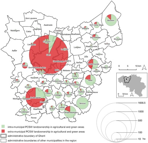
As we can see, the extensive public landownership of various public institutions call for a broader focus than just the PCSW of Ghent. However, additional analysis showed that the PCSW of Ghent alone accounts for 44,0% of all the land owned by all the various PCSWs in the region. Narrowing down on PCSWs’ landownership of agricultural and green areas only (),Footnote7 our analysis reconfirmed the large share of the PCSW of Ghent in the total area and its very high share of extra-municipal landownership. Additionally, the analysis revealed that many other PCSWs also owned extra-municipal land in agricultural and green areas – although in significantly smaller shares. None of the PCSWs except for the PCSW of Ghent itself owned land within the administrative boundaries of the city of Ghent. Finally, it was found that municipalities in the south of the region had much more PCSW landownership than municipalities in the north and northwest of the region.
Figure 2. Share of extra-municipal PCSW landownership in agricultural and green areas for all municipalities in East Flanders on 1 January 2020.
2. Evolution of public landownership and the rationales structuring public land transactions
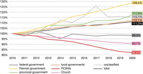
During the period 2010-2020, the total amount of public landownership in the Ghent city region increased by 11,0% (). However, we identified strong differences between different public institutions. A pronounced decrease was recorded for PCSWs (−17,8%) as well as for the Church (−9,3%). The overall increase could be mainly explained by a very pronounced increase of the landownership by the Flemish government (+28,4%), followed by the provincial government (+17,0%) and local governments (+12,1%).
Figure 3. Relative evolution of public landownership between 2010 and 2020, further subdivided by public institution category.
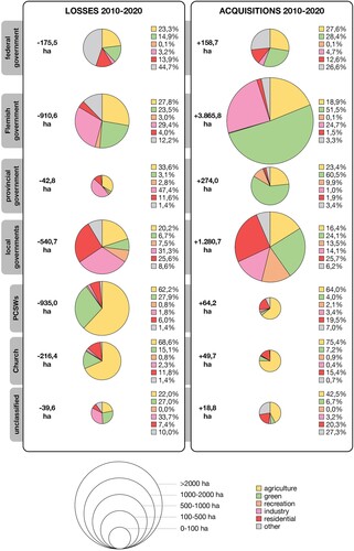
As net evolutions hide individual transactions and their potentially diverse characteristics, additional information on actual public land transactions was extrapolated (). The data showed that acquisitions and losses within the same public institution category were indeed mitigating each other. Differences in the size and nature of both acquisitions and losses were further studied to trace the rationales shaping the transactions. An analysis of the data in gave rise to the following three main observations:
PCSWs and the Church were the only public institution categories that lost far more land than they acquired. However, the losses were also offset by a limited number of acquisitions. The composition of losses and acquisitions by zoning category was very similar for both institutions. For the PCSWs, the higher proportion of residential areas in the acquisitions than in the losses was considered a possible reflection of the use of the sale of public farmland as a financing instrument (see above).
Most public institutions were clearly very active in green areas. The Flemish, provincial and local governments all realised a large share of their acquisitions in green areas and acquired far more land than they lost. What was particularly striking in the case of the Flemish government is that its public land losses were also largely located in green areas. Furthermore, PCSWs stood out because of the high proportion of green areas in their public land losses. The federal government seemed to have lost roughly as much land as it had acquired in green areas.
All public institution categories were also active in agricultural areas. Besides the pronounced losses of public farmland by PCSWs and the Church (a), we found it striking that there were also some acquisitions of farmland. For all other institutions, the share of farmland was quite or even very similar in the losses as in the acquisitions.
Figure 4. Overview of public land acquired and lost in the period 2010–2020 within each public institution category, further subdivided by zoning category.
In the following sections, we discuss the further investigation of these three observations one by one. Here, we used the detailed dataset of the public land transactions, supplemented with morphological information and information from the interviews.
2a. PCSWs’ and the Church's land sale as a financing instrument
The analysis of public land transactions of PCSWs and the Church confirmed that the historical agricultural patrimony of both institutions was structurally being lost. For the PCSW of Ghent, the data confirmed the previously described financial logic: agricultural and green land outside the city was being lost, but this was compensated by acquisitions of residential land on its own territory, dedicated to social housing and assisted-living centres projects. Between 2010 and 2020 the PCSW of Ghent lost almost a quarter of its landownership – a staggering 533,8 ha – in agricultural and green areas in the region. However, a systematic screening of the transactions of all individual PCSWs within the Ghent city revealed that the PCSW of Ghent was by no means the only one selling public land. The PCSWs of the smaller cities such as Oudenaarde and Dendermonde were also found to be losing significant shares of their patrimony. Among the PCSW losses, we even discovered former public farmland owned by the cities of Bruges, Mechelen and Leuven – cities outside the Ghent city region located respectively 40, 50 and 70 km from the city centre of Ghent. Clearly, they were also disposing of their historical agricultural patrimony outside their own municipal territory, despite all three having an urban food policy.
The transactions of the Church paralleled the PCSWs’. Here, the acquisitions in residential areas were found to be spatially concentrated in the centres of towns and villages. Following our morphological analysis, they pointed to locations with apartment buildings and detached houses. One of our interviewees suggested that these acquisitions might be related to the housing of retired priests who, upon retirement, can no longer call on government housing and whose modest pension from the federal government is often insufficient to cover their housing needs. Church institutions seem to be helping out here by acquiring residential facilities, which are probably funded through the revenues of land sales and which probably indirectly reproduces the degradation of its historical agricultural patrimony. An attempt to contact the Diocese of Ghent to verify this hypothesis remained unanswered.
2b. Extensive public land transactions in green areas
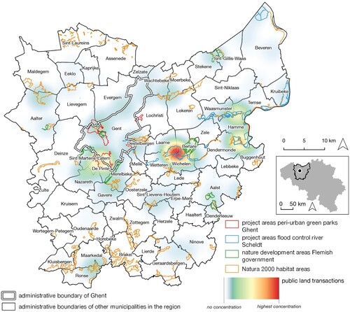
To deepen the analysis of the extensive public land transactions concerning green areas, we began by studying the acquisitions of the local, provincial and Flemish government. Building on the geography of these concentrations and following suggestions by interviewed actors, we are able to demonstrate a very strong correlation of these transactions with nature conservation, nature development and flood risk management policies (). Land acquisitions concerned the development of large peri-urban green parks around the city of Ghent, the creation of large-scale controlled flooding areas along the river Scheldt, official nature development areas of the Flemish governmentFootnote8 and numerous land acquisitions in European protected Natura 2000 habitat areas.Footnote9 Scattered throughout the region, we also identified numerous examples of local governments that acquired land for the development or expansion of park areas and nature reserves. Another prominent case was the transfer of historical woodland in Nazareth previously owned by the PCSW of Ghent to the provincial government in 2012. This transfer explains a very large part of both the losses in green areas of PCSWs and the acquisitions in green areas of the provincial government (). Interviewees indicated that this kind of transfers of green areas from PCSWs to local or higher authorities is not particularly surprising since the latter, unlike the first, have explicit competences for long-term nature management.
Figure 5. Heat map of public land acquired by all public institutions in green areas during 2010–2020 (weighted by plot area).
Looking closer at the Flemish government’s public land losses in green areas, we discovered that these represent temporary interventions in the land market. The data showed that what at first seemed to be public land losses, in reality it were transfers to lower authorities (provinces and municipalities). For some cases we could indeed detect an acquisition and a subsequent transfer to another public institution category within the 2010–2020 timeframe. Interviewees confirmed that numerous public institutions call on the Flemish government to take on a temporary land development role to realise nature development projects. This role is mainly carried out by an executive agency of the Flemish government called the Flemish Land Agency (FLA), which was also confirmed by detailed information in the database.Footnote10
Finally, the analysis of the transactions of green areas by the federal government mainly pointed to a completely different phenomenon. They were largely acquisitions and subsequent losses of land alongside railways that were being broadened or modified. This was due to the fact that after completion of the works, the public ownership rights on the unused portion of the acquired plots were often disposed of again.
2c. Numerous public land transactions in agricultural areas for non-agricultural purposes
A thorough screening of all public institutions’ transactions of agricultural land pointed to three main phenomena, alongside the structural loss of public farmland by the PCSWs and the Church which we discuss above (section 2a).
Two phenomena were strongly related to the land development operations of the Flemish Land Agency (FLA). A first phenomenon was concentrated in Sint-Lievens-Houtem, a municipality southeast of Ghent, where we observed numerous and almost simultaneous losses followed by equally numerous and simultaneous acquisitions in the transactions of the Church, PCSWs, local government and the Flemish government. Interviewed actors confirmed that these were entirely related to a large land consolidation project (‘ruilverkaveling’) in the area, carried out by the FLA. Land consolidation projects have a decades-long history: originally strongly focused on rationalizing the size and the ownership of farmland, they have gradually incorporated other themes such as the redevelopment of public spaces or water infrastructure.Footnote11 Technically, this means that all public institutions with landownership in the area (included in our dataset) temporarily transferred their land to a semi-public land bank (not included) and were subsequently allocated slightly different land positions (again included). This phenomenon was found to be an important example of an existing policy instrument with which the Flemish government organizes impressive temporary interventions and exchange operations in agricultural areas (although the project southeast of Ghent was the only one of its kind in ten years). It also explained why PCSWs and the Church seemed to acquire a limited amount of farmland in addition to the large losses (). In reality, this turned out to be a reflection of their involvement in one single land consolidation project of the FLA rather than real acquisitions.
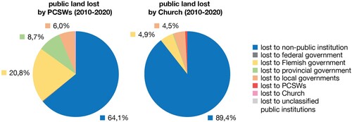
A second phenomenon was the temporary acquisition of farmland by the FLA itself. Our interviewees indicated that these acquisitions were aimed at establishing land banks in the vicinity of major nature development, forest expansion, port expansion and other infrastructure projects. The acquired farmland was used to compensate farmers suffering a loss of farmland within the project areas with farmland outside it. Our respondents also indicated that even for the FLA itself, acquiring sufficient farmland in the overheated land market of the Ghent city region is a major challenge. This helps understanding why for some years now, governments, PCSWs and the Church seeking to sell public land in agricultural and green areas are obliged to first report this to the FLA, which then holds the temporary right to purchase it at normal market value.Footnote12 This information prompted us to examine to what extent public land losses of PCSWs and the Church are actually transfers to other public institutions. The results () indicated that about 20% of the land lost by PCSWs is actually transferred to the Flemish government, while this is less than 5% for the Church.Footnote13 Several interviewees confirmed that the FLA is following the sale of PCSW farmland with great interest. The lower rates for the Church were attributed to the fact that although they are also public institutions, they are not typical governmental institutions and therefore less aligned and with a lower degree of institutional collaboration.
Figure 6. Destination of public land lost by PCSWs and the Church during 2010–2020.
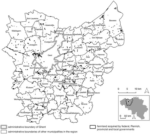
A third phenomenon concerned public land transactions in areas zoned for agricultural purposes that nevertheless serve non-agricultural purposes. Based on their geography () and supported by the morphological analysis, we distinguished three subphenomena. The first subphenomenon consisted of public land transactions for the construction or redevelopment of motorways, bicycle paths, railways and energy networks across agricultural areas. These transactions could be easily recognized in the map by their path-like geography. Here, public landownership was often of a temporary nature because large parts of the acquired parcels were disposed of again after completion of the works. Secondly, we discovered that many public land transactions in agricultural areas were explained by the establishment of permanent, non-agricultural uses. Numerous examples included football pitches, the construction of a new municipal recycling centre, farmland adjacent to an existing cemetery, farmland used for a famous annual music festival, etc. A last sub-phenomenon concerned acquisitions in agricultural areas that remained open space but for which morphological data indicated an actual non-agricultural use. Here we found examples of the afforestation of farmland, the establishment of farmland as a controlled flooding area, the construction of bivouac zones and birth forests, etc.Footnote14 To summarize, we observed that many public institutions’ transactions in agricultural areas serve a long list of non-agricultural purposes. In many cases, these are land uses for which an agricultural co-use is not even conceivable.
Figure 7. Public land acquired by the federal, Flemish, provincial and by local governments in agricultural areas during 2010–2020.
In addition to all the phenomena described above, two exceptional cases emerged from the data analysis, the interviews and the consultation of policy documents. Both are linked to public land transactions of the FLA. Although the general observations discussed above cover all main phenomena and rationales of public land acquisitions in agricultural areas, it is useful to highlight two cases that, based on morphological information and interviews, deviate from this. Both were related to policy projects of the FLA. In 2015, the FLA was able to buy dozens of hectares of farmland from the PCSW of Ghent south-east of the city (Nazareth). A large part of it was used to compensate farmers affected by a nearby forest expansion project of the provincial government. After compensation, a farmstead and almost 5 ha of farmland remained. The FLA decided to allocate this remaining patrimony to an innovative and sustainable agricultural proposal through a public call, which resulted in the sale of the site in 2021 to farmers establishing a tree nursery.Footnote15 A second case that emerged was the realization of a greenhouse horticulture cluster south-east of Ghent (Kruisem). Here, the FLA acquired more than 30 hectares of farmland at the request of the provincial government, which wanted to allocate a dedicated area for the greenhouse horticulture sector because it considered that sector important. After the acquisition, the FLA launched an open call in search of glasshouse horticultural companies wishing to settle on the site. In the following years, the land was sold to two tomato and an aquaculture company.Footnote16 Orthoimagery confirmed the development of this former open farmland area into a greenhouse cluster as soon as the site was transferred to its new users.
Discussion
Our research started from the thesis that the mobilization of public land for the development of urban food policy requires a good understanding of existing public landownership and the current modus operandi of public institutions in the urban land market. To test and substantiate this hypothesis, we critically examined the reality of public landownership and public land transactions in the Ghent city region. The results largely demonstrated the continuation of an urbanism that is not based on agricultural or food-related aspects and in that sense confirmed the need to look beyond iconic food growing initiatives on public farmland for the benefit of its structural development. The methodology adopted and illustrated here enables us, on the one hand, to identify a number of land transaction logics unified by the lack of a coherent urban agenda and, on the other, to provide elements for the construction of alternatives.
Ghent’s supposed ‘best practices’ of food growing on public farmland are not representative of public land policy in the urban region and are not part of the construction of a broader urban geography of farming: on the contrary, they so far exist in the context of a systematic sale of public farmland. The sale does not only apply to the city of Ghent and its PCSW, but also to various other PCSWs and the Church in the region that sell centuries-old agricultural patrimony at high speed. Both align very strongly with the unfortunate trends of using (selling) public assets as a financing instrument to maintain the illusion of economic growth, as denounced by both academic debates (Merrifield Citation2014a, Citation2014b) and investigative journalism in Flanders (Vanden Bussche Citation2019).
Alongside these sales, even when not changing hands, agricultural land is also typically and regularly sacrificed – within municipal and regional public land policies – to make space for a wide range of non-agricultural land uses. Both trends confirm that celebrated urban food growing projects on public farmland may not only be anecdotal, but also not engaged in challenging of food-disabling urbanization dynamics (Tornaghi Citation2017).
Our study also demonstrates a profound lack of municipal interdepartmental, intermunicipal and multi-level cooperation to support urban food strategies. Although Ghent’s urban food policy is in several respects not limited to its own territory (City of Ghent Citation2016), this apparently applies to the valuation and use of existing public agricultural patrimony. This can be understood as a strong institutional break between the urban food policy and the urban land policy of Ghent and its PCSW, but also as an institutional break between the city and its surrounding municipalities which is very clearly reflected in how the regional geography of the historical agricultural heritage is currently dealt with. From a multi-level perspective, it is striking that local governments do call on (the land policy instruments of) the Flemish government for the development of park and nature areas, but not for local food policy or other agriculture-related policy objectives. Interestingly, the Flemish Land Agency itself states that it would be pleased to welcome more food- and agriculture-related requests (Borgo Citation2021; Celen and Van Gijseghem Citation2022). In the meantime, it recently purchased 3 hectares of land for short-chain agriculture in the urban fringe of Brussels to ‘gain knowledge and experience to further shape future policy on short-chain and local food strategies’ (own translation, from Vlaamse Landmaatschappij Citation2021b, 3). This accentuates both the opportunity and the urgent need to address the lack of multi-level governance in the deployment of public land policy to support the development of urban food policies.
With a total area of about 28.000 ha (around 10%) and around two-thirds of it allocated for agricultural and green purposes, the data we have rendered public through this work supports the idea that public landownership can play an important role in the context of urban food policy and peri-urban open space policy in general. These figures are a welcome addition to literature on the total loss of the historical commons in Belgium (Brown Citation2005; De Moor Citation2002), which usually do not offer insight into landownership of public institutions today. The large amount and variety of public land transactions that we have illustrated offers several tools to shape the political mobilization of local and farmers communities mobilizing around the issue of public landownership. The willingness of various public institutions to invest in public land policy for biodiversity, nature conservation and flood risk management could be an opportunity to not only oppose the sale of existing patrimony, but to advocate for similar efforts for agricultural purposes. This could mean, for example, not only the structural introduction of agricultural co-use, but also the mobilization of existing land policy instruments to the purpose of food-related objectives – of which the analysis revealed a number of interesting but rare examples. Finally, these results reconfirm the importance of data as key facilitator for the development and implementation of urban food policies.
Thanks to our broad and data-driven design, we were able to validate and demonstrate the importance of our central thesis in this research paper. We believe that our research can contribute, both methodologically and through its conclusions, to both, the development of similar exercises in other contexts and to the reshaping of mobilization trajectories on behalf of urban and peri-urban farming communities, and their allies concerned with the effective progressing of urban food policies.
It would be particularly beneficial to carry out similar data exercises for other metropolitan contexts and possibly for the whole of Belgium, to strengthen our understanding of national dynamics and potential synergies between mobilized communities. We also believe comparative research on a European level could be very relevant, allowing both similarities and variations in the reality of public landownership and transactions to be traced (building on precedents such as Vranken et al. Citation2021) and for potentially innovative models in the regulation and management of public farmland to be shared . This would allow for cross-learning, not only in light of urban food policy but for many other applications as well. Similarly, the topic of public land in relation to urban food policy offers a very concrete, topical and fairly new approach for further research on metropolitan governance (ESPON Citation2018; Simeonova et al. Citation2018).
While we discuss more concrete examples of how public land can contribute to the development of urban food policies elsewhere in our workFootnote17, we recognize that a finer characterization of public land and its actual use than merely the zoning category to which it belongs, is an immediate direction to further develop our work. As planned and actual land uses sometimes differ significantly (Verhoeve et al. Citation2015) and are not very helpful in overcoming the administrative and epistemic rift between nature and agriculture (Schneider and McMichael Citation2010), there are many opportunities to further develop our analysis. Indeed, we are currently working on intersecting public land data with detailed data on actual agricultural use.Footnote18 This will allow us to construct new dialogues across agrarian and urban food movements, to gain a more concrete understanding of the impact of the sale of public farmland on its actual agricultural use(rs) and together with this paper will create a good basis for a well-informed mobilization of public landownership for supporting urban food policy.
Finally, our research unintentionally provides opportunities for historical research, including reconstructing the history of the PCSW and church patrimony and better understanding its extraordinary geography.
Conclusions
This paper departed from observing the growing international attention on the use of public land for developing urban food policies. This comes with a strong focus, both in research and in policy, on iconic cases of urban food growing on public land. It often lacks a good understanding of existing public landownership and the current modus operandi of public institutions on the urban land market. As a result, it is mostly unclear how representative the projects are and almost impossible to ascertain the extent to which they actually hold a transformative potential to reshape persistent food-disabling urbanization dynamics. Using original Belgian Land Registry data, we constructed a unique, empirically grounded, cartography of public landownership and public land transaction for the Ghent city region in Belgium. Ghent was selected as a case study on the one hand because of its internationally celebrated urban food policy and on the other due to its simultaneous civic mobilization and contestation against the sell-off of its historical agricultural patrimony. The analysis of public land transactions between 2010 and 2020 demonstrated that the two ‘best practices’ of Ghent’s urban food policy realised on public land so far exist in the context of a systematic large-scale sale of public farmland and are not part of the construction of a broader urban geography of farming. In fact, the lack of agricultural and food-related motivations turned out to be more extensive (drastic sell-off), more universal (several public institutions) and more structural (structured by other rationales) than these actors have been able to assess on the basis of the limited information they relied on so far. In this sense, the results demonstrated a lack of a coherent urban agenda, but also provided elements for the construction of alternative practices. We conclude that in order for urban food growing projects on public land to meaningfully contribute to a progressive and food-empowering urban agenda, a good understanding of existing public landownership and the current modus operandi of public institutions on the urban land market is essential. Our work offers several opportunities for follow-up research in and beyond the Ghent city region.
Acknowledgements
We highly appreciated the financial support of ESPON for writing this article, the help of the Belgian Land Registry for supplying the original data, the interviewees for their time and comments on the results of the data analysis and the anonymous reviewer(s) for their detailed and constructive feedback.
Disclosure statement
No potential conflict of interest was reported by the author(s).
Data availability statement
The original data that support the findings of this study are available from the Belgian Land Registry. These data are not publicly accessible, but can be requested based on the principle of open government provided for in the Belgian Constitution.
Additional information
Funding
Notes
2 See https://www.geopunt.be/catalogus/webservicefolder/418e8e4a-12c1-80a8-8306-fcf4-799c-581d-c4e38594.
3 In Belgium, some church institutions are considered public institutions and are therefore included in the analysis; others are legally constituted as non-profit organisations and are therefore not included. For the sake of simplicity, we will use ‘the Church’ to refer to public church institutions. Public church institutions are an institutional oddity. We know that they own significant amounts of farmland, face structural financial challenges, and have a centuries-old patrimonial link with the predecessors of PCSWs. For more information we refer to specialised literature (Van Dooren Citation2015).
4 This category includes a number of public institutions that could not be placed in any of the previous categories, including some that are responsible for managing drainage systems at the sub-local level.
5 This plan is continuously updated. We used the version on 1 January 2020. For more information, see https://omgeving.vlaanderen.be/ruimteboekhouding-rsv.
6 Since roads and rivers do not have cadastral parcels, for our study we measure public landownership in relation to the total area of all cadastral parcels in the city region of Ghent – not to the total area of the entire territory.
7 By focusing on these two zoning categories, the figures are not distorted by residential PCSW patrimony, which was almost exclusively located within the own territories of the PCSWs.
10 For a general description of the FLA, see https://www.vlm.be/en.
11 For more information on this trend, see Vlaamse Landmaatschappij (Citation2000).
12 For more information, see Vermeulen (Citation2017).
13 The transfers from PCSW to the provincial and local governments are strongly related with the transfer of existing natural areas (see earlier).
14 A bivouac area is a small scale legal and authorized camping spot. Birth forests are afforestation projects to commemorate newborns, whereby the trees are often financed by parents or relatives.
15 For more information, see Vlaamse Landmaatschappij (Citation2018, Citation2021a).
16 For more information, see Vlaamse Landmaatschappij (Citation2019).
18 This concerns LPIS data (land parcel identification system) that are compiled by the Flemish government within the framework of the European IACS commitments (integrated administration and control systems).
References
- Access to Land Network. 2017. Supporting Access to Land for Farmers in Europe: Experiences and Potential of Local Authorities. https://www.accesstoland.eu/IMG/pdf/a2l_handbook_local_authorities.pdf
- Artioli, F. 2021. “Sale of Public Land as a Financing Instrument. The Unspoken Political Choices and Distributional Effects of Land-Based Solutions.” Land Use Policy 104. doi:10.1016/j.landusepol.2020.105199.
- Baysse-Lainé, A., C. Perrin, and C. Delfosse. 2018. “Le Nouvel Intérêt des Villes Intermédiaires Pour les Terres Agricoles: Actions Foncières et Relocalisation Alimentaire.” Géocarrefour 92 (4). doi:10.4000/geocarrefour.10417.
- Borgo, E. 2021. Samen Voedselland Realiseren. Brussel: De Grote Verbouwing.
- Brown, K. 2005. Contemporary rural change and the enactment of common property rights: the case of crofting common grazings. https://www.proquest.com/openview/5dd341e150563d957b26f2cc0c1589a2/1?pq-origsite=gscholar&cbl=51922&diss=y
- Cabannes, Y., and C. Marocchino, eds. 2018. Integrating Food Into Urban Planning. London: PB - UCL Press.
- Calori, A., E. Dansero, G. Pettenati, and A. Toldo. 2017. “Urban Food Planning in Italian Cities: A Comparative Analysis of the Cases of Milan and Turin.” Agroecology and Sustainable Food Systems 41 (8): 1026–1046. doi:10.1080/21683565.2017.1340918
- Candel, J. 2020. “What’s on the Menu? A Global Assessment of MUFPP Signatory Cities’ Food Strategies.” Agroecology and Sustainable Food Systems 44 (7): 919–946. doi:10.1080/21683565.2019.1648357
- Celen, G., and D. Van Gijseghem. 2022. “Geïntegreerde gebiedsgerichte aanpak.” https://www.salv.be/salv/evenement/salv-toekomstdialoog-ruimte-landbouw
- Christophers, B. 2018. The new Enclosure: The Appropriation of Public Land in Neoliberal Britain. London: Verso.
- City of Ghent. 2016. “From Strategic to Operational Goals for the Gent en Garde Food Policy: Recommendations of the food policy council.” Ghent: City of Ghent. https://stad.gent/sites/default/files/page/documents/20160913_PU_Gent%20en%20garde_operationele%20doelstellingen_Engels_web.pdf
- Colombo, L., S. Grando, and G. Lepri. 2021. “Urban Agrarian Alliance Building in Peri-Urban Rome.” In Resourcing an Agroecological Urbanism: Political, Transformational and Territorial Dimensions, edited by C. Tornaghi, and M. Dehaene, 85–100. London: Routledge.
- De Boeck, A., and I. Hiergens. 2021. “Landbouwers en Burgers in het Verweer Tegen de Verkoop van Publieke Gronden.” Tijdschrift Voor Agrarisch Recht 11: 521–525.
- De Moor, T. 2002. “Common Land and Common Rights in Flanders.” In The Management of Common Land in North West Europe, c. 1500-1850, edited by M. De Moor, and L. Shaw-Taylor, 113–141. Turnhout: Brepols.
- De Schryver, J. 2000. Algemeen Overzicht van het Patrimonium OCMW-GENT. Gent: OCMW Gent.
- ESPON. 2018. “SPIMA – Spatial Dynamics and Strategic Planning in Metropolitan Areas.” https://www.espon.eu/metropolitan-areas
- Forster, T., F. Egal, H. Renting, M. Dubbeling, and A. Getz Escudero. 2015. “Milan Urban Food Policy Pact. Selected Good Practices from Cities.” Milano: Fondazione Giangiacomo Feltrinelli. https://fondazionefeltrinelli.it/schede/ebook-utopie-milan-urban-food-policy-pact/#top
- Franco, J., and S. Borras, eds. 2013. Land concentration, land grabbing and people’s struggles in Europe: Transnational Institute, European Coordination Via Campesina, Hands off the Land network. https://www.tni.org/files/download/land_in_europe-jun2013.pdf
- Harvey, D. 1985. The Urbanization of Capital. Oxford: Blackwell.
- Ilieva, R. 2016. Urban Food Planning: Seeds of Transition in the Global North. Oxon, NY: Routledge.
- IPES-Food. 2017. What Makes Urban Food Policy Happen? Insights From Five Case Studies. https://www.ipes-food.org/_img/upload/files/Cities_full.pdf
- Jarrige, F. 2018. “Patrimoine Agraire et Développement Urbain: Le cas des Domaines de Lausanne.” Études Rurales 201: 140–165. doi:10.4000/etudesrurales.12336
- Kerselaers, E., A. Coussement, J. Charles, L. Goethijn, E. Naessens, H. Tency, and D. Vereecke. 2020. “PROSPERA Regional Report – City of Ghent: An Analysis of the Peri-Urban Area that Surrounds the City of Ghent.” Ghent: PROSPERA project (Interreg Europe). https://projects2014-2020.interregeurope.eu/fileadmin/user_upload/tx_tevprojects/library/file_1612109316.pdf
- Longhurst, M. 2019. How Nature-and-People-Connected Food Growing Projects are Accessing and Securing Land: A Brief Report on the Current Picture in the UK. Bristol: Green Future Associates. https://www.greenfuture.org.uk/wp-content/uploads/2020/09/How-nature-and-people-connected-food-growing-projects-are-accessing-and-securing-land-in-the-UK_.pdf
- Merrifield, A. 2014a. “Against Accountancy Governance: Notes Towards a new Urban Collective Consumption.” City 18 (4-5): 416–426. doi:10.1080/13604813.2014.939463
- Merrifield, A. 2014b. The New Urban Question. London: Pluto Press.
- Miklos, A., A. Onorati, F. Pacheco, I. Mammana, G. Simula, R. Grey, … M. Meunier. 2020. Your Land, My Land, Our Land: Grassroots Strategies to Preserve Farmland and Access to Land for Peasant Farming and Agroecology. https://www.tni.org/files/publication-downloads/en-your_land_my_land_our_land.pdf
- Milan Urban Food Policy Pact. 2015. (15 October 2015 ed.). Milan.
- Moragues-Faus, A. 2021. “The Emergence of City Food Networks: Rescaling the Impact of Urban Food Policies.” Food Policy 103: 102107. doi:10.1016/j.foodpol.2021.102107.
- Moragues-Faus, A., and A. Marceau. 2019. “Measuring Progress in Sustainable Food Cities: An Indicators Toolbox for Action.” Sustainability 11 (1): 45. doi:10.3390/su11010045.
- Moragues-Faus, A., K. Morgan, H. Moschitz, I. Neimane, H. Nilsson, M. Pinto, H. Rohracher, et al. 2013. Urban Food Strategies: The Rough Guide to Sustainable Food Systems. https://orgprints.org/id/eprint/28860/1/foodlinks-Urban_food_strategies.pdf
- Morgan, K. 2009. “Feeding the City: The Challenge of Urban Food Planning.” International Planning Studies 14 (4): 341–348. doi:10.1080/13563471003642852
- Morgan, K. 2013. “The Rise of Urban Food Planning.” International Planning Studies 18 (1): 1–4. doi:10.1080/13563475.2012.752189
- Nyéléni Europe and Central Asia. 2021. Roots of Resilience: Land Policy for an Agroecological Transition in Europe. https://www.organicseurope.bio/content/uploads/2021/02/rootsofresilience_online-light.pdf?dd
- Perrin, C. 2017. “Mobiliser la Propriété Publique en Faveur de L’agriculture Périurbaine? Le cas de la Région de Montpellier (France).” VertigO 17 (1). https://doi.org/10.4000/vertigo.18401
- Perrin, C., and A. Baysse-Lainé. 2020. “Governing the Coexistence of Agricultural Models: French Cities Allocating Farmlands to Support Agroecology and Short Food Chains on Urban Fringes.” Review of Agricultural, Food and Environmental Studies 101 (2): 261–286. doi:10.1007/s41130-020-00105-z
- Pothukuchi, K., and J. Kaufman. 2000. “The Food System: A Stranger to the Planning Field.” Journal of the American Planning Association 66 (2): 113–124. doi:10.1080/01944360008976093
- Schneider, M., and P. McMichael. 2010. “Deepening, and Repairing, the Metabolic Rift.” Journal Of Peasant Studies 37 (3): 461–484. doi:10.1080/03066150.2010.494371
- Simeonova, V., M. van Eupen, J. Clement, A. Baraggia, E. van der Grift, G. Sandkjær Hanssen, … E. Gerohazi. 2018. SPIMA - Spatial Dynamics and Strategic Planning in Metropolitan Areas: Targeted Analysis (Final Report). Luxembourg: ESPON EGTC. https://www.espon.eu/sites/default/files/attachments/SPIMA%20Final%20Report.pdf
- Sonnino, R. 2019. “The Cultural Dynamics of Urban Food Governance.” City, Culture and Society 16: 12–17. doi:10.1016/j.ccs.2017.11.001
- Stad Gent. 2014. Patrimonium OCMW Gent in Beheer van Sogent: Visienota - Plan van Aanpak 2014-2019. Gent: Stad Gent.
- Stad Gent. 2016. Patrimonium OCMW Gent in Beheer van Sogent: Visienota - Plan van Aanpak 2016-2019. Gent: Stad Gent.
- Stad Gent. 2021. Beheer en Verkoop Patrimonium OCMW Gent in Beheer van Sogent: Periode 2020-2025. Gent: Stad Gent.
- Tornaghi, C. 2017. “Urban Agriculture in the Food-Disabling City: (Re)defining Urban Food Justice, Reimagining a Politics of Empowerment.” Antipode 49 (3): 781–801. doi:10.1111/anti.12291
- Tornaghi, C., and M. Dehaene. 2020. “The Prefigurative Power of Urban Political Agroecology: Rethinking the Urbanisms of Agroecological Transitions for Food System Transformation.” Agroecology and Sustainable Food Systems, 1–17. https://doi.org/10.1080/21683565.2019.1680593
- Tornaghi, C., and M. Dehaene. 2021a. “Introduction: Embracing Political Agroecology, Transforming Sustainable Food Planning.” In Resourcing an Agroecological Urbanism: Political, Transformational and Territorial Dimensions, edited by C. Tornaghi, and M. Dehaene, 1–11. London: Routledge.
- Tornaghi, C., and M. Dehaene, eds. 2021b. Resourcing an Agroecological Urbanism: Political, Transformational and Territorial Dimensions. London: Routledge.
- UNFCCC. 2019. “Winners of the 2019 UN Global Climate Action Awards Announced [Press Release].” https://unfccc.int/news/winners-of-the-2019-un-global-climate-action-awards-announced
- van der Valk, A., and A. Viljoen. 2014. “AESOP's Thematic Groups – Part 3: The Sustainable Food Planning Thematic Group.” disP - The Planning Review 50 (4): 78–82. doi:10.1080/02513625.2014.1007647
- Van Dooren, B., ed. 2015. Kerkfabrieken in Vlaanderen: Een Erfenis van Napoleon Voor de Toekomst. Brugge: Vanden Broele.
- Vanden Bussche, S. 2019. “Op Drie Jaar Verkopen Steden en Gemeenten Grond Ter Grootte Van Brussel-stad.” https://www.apache.be/2019/06/07/op-drie-jaar-verkopen-steden-en-gemeenten-grond-ter-grootte-van-brussel-stad/
- Vandermaelen, H., E. Beeckaert, I. Hiergens, and L. Deruytter. 2020. “Publieke Gronden: Marktwaarde of Gebruikswaarde? Uitverkoop Verdringt Noodzakelijk Debat Over Potentiële Gebruikswaarde.” Bodem 1: 6–8.
- Verhoeve, A., V. Dewaelheyns, E. Kerselaers, E. Rogge, and H. Gulinck. 2015. “Virtual Farmland: Grasping the Occupation of Agricultural Land by non-Agricultural Land Uses.” Land Use Policy 42: 547–556. doi:10.1016/j.landusepol.2014.09.008
- Vermaerke, M. 1995. “OCMW: Historiek en Actuele Uitdagingen.” De Gemeente 70 (474): 408–411.
- Vermeulen, H. 2017. “Kort & Bondig: Het Recht van Voorkeur.” Buitenkans(June 2017), 30–31.
- Vlaamse Landmaatschappij. 2000. “Ruilverkaveling, veel meer dan kavels ruilen.” Brussel. https://publicaties.vlaanderen.be/view-file/288
- Vlaamse Landmaatschappij. 2018. “Verkoop site Langedreef.” Gent: Vlaamse Landmaatschappij. https://www.vlm.be/nl/SiteCollectionDocuments/Verkoop%20hoeve%20Langedreef/Brochure%20verkoop%20site%20Langedreef.pdf
- Vlaamse Landmaatschappij. 2019. “Stokstorm.” https://www.vlm.be/nl/projecten/Paginas/Stokstorm.aspx
- Vlaamse Landmaatschappij. 2021a. “Nieuwe Toekomst Voor de Hoeve Aan de Langedreef in Nazareth: Boomkwekerij Met Bomenasiel.” https://pers.vlm.be/nieuwe-toekomst-voor-de-hoeve-aan-de-langedreef-in-nazareth-boomkwekerij-met-bomenasiel
- Vlaamse Landmaatschappij. 2021b. “Open Oproep Ruimte Voor Voedsel Met Toewijzing Van Landbouwgronden Voor Een Korteketenlandbouwproject in Vogelzang, Sint-Pieters-Leeuw.” https://www.vlm.be/nl/SiteCollectionDocuments/RuimtevoordeVlaamseRand/BRAVRRuimtevoorvoedselOproepvogelzang.pdf
- Vlaamse overheid. n.d. “Decreet Lokaal Bestuur.” https://lokaalbestuur.vlaanderen.be/decreet-lokaal-bestuur
- Vranken, L., E. Tabeau, P. Roebeling, and P. Ciaian. 2021. Agricultural land market regulations in the EU Member States. https://publications.jrc.ec.europa.eu/repository/handle/JRC126310