
ABSTRACT
In this paper we use a patches approach to study changes in local land-use practices in response to constraints of labour and the increasing effects of climate change. Drawing on a mix of different participatory exercises and in-depth interviews we describe five categories of land use patches in two contrasting study areas in Nepal. We examine how decreasing access to land, labour and water generate socially differentiated local landscapes. Our findings point toward adaptive land-use responses that secure a subsistence production, encourage close integration between crop and tree land practices, but are supported by a remittance economy. This logic of local land use is not recognised by either agricultural or forestry institutions. We argue that an ongoing debate on land abandonment in Nepal is an example of how narrow sectoral understandings fail to comprehend adaptation practices in a complex landscape system.
Introduction
The stories told about the environmental state of Nepalese mountains have swung from pessimism with the Himalayan environmental crisis narrative in the 1970s and 1980s (Ives and Messerli Citation1989) to hope in the 2000s with the return of forest cover in the mid-hills as a result of the community forest programme (Gautam et al. Citation2003; Niraula et al. Citation2013). Now there is a new story emerging of abandoned agricultural land and an underutilisation narrative that sees an increasing problem in that ‘agricultural land is being abandoned or underutilised’ (Ojha et al. Citation2017, 157). Added to this have been concerns over degradation associated with the uncultivated land, bajho jagga (Jaquet et al. Citation2019).
Central to these narratives has been the state of Nepal’s forests, and the notion of dependence on forest resources of fodder and browse in particular, to support labor-intensive subsistence farming systems (Schroeder Citation1985). As forest resources declined, organic input availability decreased and the labour time rose to collect what was available to support farm productivity (Blaikie and Coppard Citation1998), underpinning an environmental pessimism. But as tree cover through the community forest programme recovered, restrictions on forest use for livestock, in particular, has led to a gradual uncoupling of forest–agricultural interlinkages. The gradual increase in restrictions on forest use rights by the forest department has further contributed to this (Khatri et al. Citation2017). While the forests still provide benefits (Paudel Citation2016) in kind and in cash the notion of rural people’s strong forest dependence has lived on. However, the evidence (Marquardt et al. Citation2016) points more to reduced direct use of forests and increasingly self-contained ecosystem service flows within agricultural areas with on-farm trees used for fodder and intensified livestock systems supporting a slowly commercialising agriculture.
However, the limits to the ability of the mountain farming systems to support a growing population has been a constant element in people’s lives. And when the possibilities run out people have moved (Sugden et al. Citation2018). More recently and to greater effect on Nepal’s agrarian economy there has been major labour movement to the Middle East. Now some one-third of rural population has one or more members working abroad and sending remittances home (Sunam and McCarthy Citation2016). This growth of a remittance economy has averted an agrarian crisis that was anticipated in the 1980s (Blaikie et al. Citation1980). But it has not resolved the underlying structural constraints to the agrarian economy of shrinking farm sizes and deep social inequalities. As Sugden et al. (Citation2018) indicate given the terms of employment in the labour migration economy, for many the level and reliability of remittances may not be a route to either permanently escape or transform agriculture, and subsistence remains a cornerstone of the rural economy.
But the level of outmigration has induced a labour shortage leading to a retreat of the cultivation boundary. This has generated its own environmental story, the bajho jagga debate. It echoes a wider global debate about land abandonment which captures both shifts in land use as well the giving up of land for any form of use (Quiroz et al. Citation2014). But should we believe this story any more than some of the earlier accounts of crises and junctures that have failed to be consequential? Certainly labour has played a crucial role in providing conditions for long-term landscape investments (so-called landesque capital, see Blaikie and Brookfield Citation1987) in irrigation, terracing, community forest recovery and so forth to maintain landscape integrity. But does less labour lead to things falling apart – a sort of reversal of the ‘More People Less Erosion narrative (Tiffen et al. Citation1994)? Much depends on ‘where’, ‘how’ and at ‘whom’ you look.
With respect to the ‘where’ if there is one thing that has been learned about Nepal’s landscape is the significance of site specificity (Marquardt et al. Citation2016) and the importance of the ecology of local knowledge (Blaikie and Coppard Citation1998). The ‘where’ is also related to the ‘how’ you look. Though individual professionals might be more sensitive to the complexity of rural landscapes, sectoral institutional perspectives tend to be more dogmatic and do not take an integrated view on land use and vegetation. Rather, their sectorial lenses that divide forest from agriculture fails to appreciate the trees in agricultural landscapes (Marquardt et al. Citation2016). For forestry institutions they are not part of the forest, for the agricultural sector the spread of trees is not really relevant to the fields’ production and more of an encroachment on the farming territory. The agricultural landscape can also be viewed through land use categories and taxation classes (Regmi Citation1977) distinguishing between irrigated paddy land (khet), dryland (bari) and un-ploughed farm land (kharbari, pakho etc). This production based perspective introduces its own biases of what is and is not seen.
But if we are to think of site specificity neither the sectoral lens nor production-based land classes operate at a sufficiently fine scale to capture the micro-management of landscapes that are evident in farmer practice. Rather, a more ecological approach is required that responds to what Jodha (Citation1992) conceptualised as mountain specificities and in particular of heterogeneity, niche and human adaptation mechanisms. In earlier research (Marquardt et al. Citation2016), field observations indicated that practices of land use were present that were not appreciated with existing land use categories. These included divisions of land use within the dryland (bari), land where more distant and marginal sections were managed for fodder and grazing and other tree products supporting more intensive production in higher potential areas of the bari. However, access to these various resources is not evenly distributed between village households and these practices have to be understood in terms of who has access to what. It is the findings from an enquiry into the socially differentiated nature of actual land-use practices as forms of localised intensification in response to constraints and pressures that this paper addresses.
The paper uses the concept of patches drawing from Jodha’s idea of niche to capture specific biophysical units, distinct topographies, soil types and vegetation cover. But we add to the bio-physical aspect of patches recognition of their social origins in that they have been formed by specific social group management practices that shape spatially diverse land uses (Sinare et al. Citation2016; Scoones et al. Citation2017). The patches, discussed in this paper often overlap with existing land use categories. They are the irrigated fields (khet), rain-fed areas (bari), different locations of extensively managed fodder areas (kharbari, khar pakho, gas baan and kanlo), the homestead and forest areas. These categories coincide with the terms used by villagers when they talk about their land management practices. This integrated spatially diverse land use has been well described in older Nepalese literature (Schroeder Citation1985). But more recent Nepalese livelihood and land use studies almost exclusively focus on khet, bari and community forests. Land use outside these three ‘principal’ categories, such as fodder areas and the homestead, are scarcely acknowledged although as the data will show, these ‘invisible’ areas provide significant contributions to the household economy.
This patches approach is used to explore changes in land use and management as responses to labour constraints but also the effects of climate change in two contrasting landscapes. We elaborate a micro-level understanding of these by exploring how people in juggling with their various resources draw on the potential of different land use patches. In doing so, spatially diverse but interlinked forms of intensification become visible. This understanding offers a rethinking of landscape categories and rationales of land use. However, access to these patches is not equally distributed within the villages and there are differences between the poorest and the better-off households. The inquiry has been framed by three research questions.
What land-use patches are present in the local landscape, how are they managed and what benefits do different groups of people derive from them?
How does the use of these different patches vary in relation to environmental and socio-economic constraints?
What are the implications of a patches approach to the understanding of land use management practices and adaptation responses to labour availability changes and climate change in particular?
The paper starts with a brief review of the patches method and the findings explore the significance of place to integrated landscape use practices and how these differ between social groups within the villages. The paper concludes with a discussion of the contribution that a patches approach makes to understanding landscapes management practices and their implications for adaptation to changing demographics and climate change.
Methods
Ramechhap district (in the Mid Hills) and Sindhuli district (in the ChureFootnote1 mountain range), both in the south-eastern Nepal, were selected as field sites due to their contrasts in climate, topography, land-use history, and processes of socio-economic change.
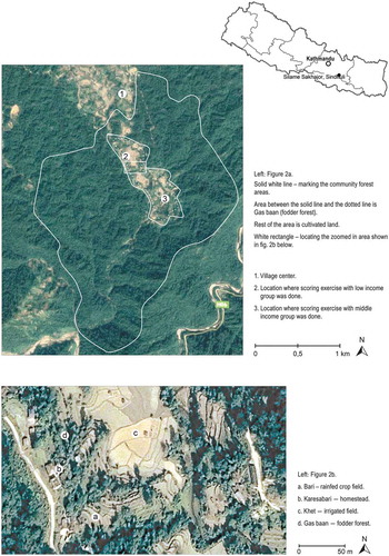
In each district, three villages were selected, in Ramecchap to capture contrasts in levels of water stress and in Sindhuli differences in community forest use and management approaches. Detailed villages studies were carried out during August to December 2017. The analysis focuses on two of the case villages, Rampur (in Ramcchap) and Silame Sakhajor (in Sindhuli). Where appropriate these are contrasted with the other study villages to emphasise the variability and trends within and between contexts. Rampur can be seen as a “typical” Mid-hill village, socially mixed with meagre forest resources, struggling with drought and high levels of out-migration (, and ). Silame Sakhajor has rich forest resources, farm lands that are both productive and increasingly commercial oriented due to close connectivity with an urban centre, see (, and ). The term ‘study village’ is used to refer to the residential area linked to a Community Forest User Group (CFUG) as there can be more than one CFUG per village.
Table 1. Description of case study villages
Figure 1. Study area in Rampur, Ramechhap. Maps: Google Earth.com
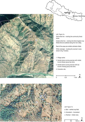
Figure 2. Study area in Silame Sakhajor, Sindhuli. Maps: Google Earth.com
In each study village we followed a five-step methodology. This drew on Sinare et al.’s (Citation2016) method for assessing the local use of ecosystem services and the agro-ecological variability of land use. An assessment of the socially differentiated nature of access to different land resources and ecosystem services was added.
First a group discussion was held where the CFUG executive committee explained the village history and features and how life had changed. This was followed by a group discussion on trends in forest use, agricultural productivity and water access. A village resource map was drawn identifying the location of settlements, forest areas, farm areas, fallow areas, abandoned farm land, water sources and other key features. A seasonal calendar explaining the work in the fields and forest throughout the year was developed. All discussion activities and interviews were made in Nepali.Footnote2
In the second step a transect walk through the different land-use types was undertaken with a group of villagers. This ground truthed the resource map and built understanding of the landscape use and interests of different social groups. These first two steps helped identify local landscape units or “patches”, and understand the use and flows of certain ecosystem services (e.g. water, soil nutrients, etc.).
In the third step we elaborated a land-use matrix with two different groups of smallholders, one of poorer farmers and a second of middle-income farmers. The identification of the members of each group was based on a household wealth ranking of its members by the CFUG steering groups. In Ramecchap this built on an exercise undertaken about 10 years earlier by a Swiss forestry project (Hobley and Jha Citation2012). The CFUGs in Sindhuli had not gone through this process, so the CFUGs were asked to identify very poor/poor and middle-income households. Drawing on the developed resource map, a discussion was held on what each group considered as the main land use patches that they used.
The fourth step was a scoring exercise concentrating on what kind of products households obtained from the different patches they identified. The two wealth groups identified in step three then discussed what food products were grown and where this was done. For each food category (e.g. rice, maize, cereals, legumes, etc.) the participants distributed 20 beans between the different patches showing the relative importance of the different land use patches for specific crops. This exercise was then repeated for the various sources of animal feed and ‘forest’ products.
In step five semi-structured in-depth household interviews were held. In addition to households from the two wealth groups, we also purposefully included interviews from households who drew on specific landscape resources (e.g. blacksmith, bamboo basket maker, fuelwood seller). The interviews focused on the particular household’s use of their land and larger landscape. They were asked about patterns of change within their household. This included household size and composition, land holdings, productivity, labour availability, fuel wood use, food security, forest use and land value now and 20 years ago. These interviews contributed to our understanding and analysis of the wide heterogeneity and the mico-managment of niches in mountain farming systems and land uses changes over time. Thirteen household interviews were made in Ramechhap and sixteen in Sindhuli. In addition, outside perspectives on forest use and changes from interviews with seven key informants in the District Forest Office (DFO) and Federation of Community Forest Users, Nepal (FECOFUN) were collected.
Five categories of land use patches were found in the two villages (). Most households work within several or all these patches and the different patches are scattered across the landscape ( and ).
Table 2. Description of patches identified in Rampur and Silame Sakhajor. Categories in order of an assessed over all importance
Results
Walking the two study landscapes: seeing the patches
Rampur
If one stands in Rampur’s village centre and looks down the valley two features are clear (see ). First all the land is downslope from the village and everything has to be carried upslope. Second all this land is used. The mountain side is subdivided by terraces, ridges and stone walls with a gradation of different vegetation densities. At first sight the mountain side appears to be covered with bari fields. But walking through the landscape different patches of land use become visible.
Walking downslope, the land closest to the village is covered by numerous well-kept bari fields. They are very small so that it can be difficult to turn a plough around. These narrow belts of land are supported by stone terraces. They are planted with different combinations of intensively managed grains (mainly maize and millet), legumes, tubers, vegetables and spices. But the fields also often support a sparse line on the borders of various fodder and timber tree species. The grass growing on the ridges between the fields is used as animal fodder.
As the path continues around the farm houses there are more fodder trees such as. khanyu (Ficus semicordata), kutmiro (Litsea polyantha), ipil-ipil (Leucaena leucocephala, dumri (Ficus racemose) and fruit trees such as banana, papaya and sugar apple supporting perennial climbers. These form a boundary between the bari fields and the homestead (kareshabari). The court yard is the heart of the homestead; here tethered animals eat the collected fodder, and a variety of plants for daily needs such as chili, coriander, ginger, leaf vegetables (mustard greens), vegetables, medicinal herbs, etc., are growing in small areas.
Beyond the homesteads, less well-maintained bari land and areas of leafy vegetation start to appear. These contain stands of grass, bushes and trees used for fodder and construction material such as bamboo and timber trees i.e. kharbari land. This perennial kharbari vegetation may be long-standing traditional kharbari areas, but kharbari is increasingly found on what used to be bari land, a previous land use indicated by the terraces. The reasons for the abandonment were often cited as being due to the field’s poor soil conditions, or disadvantageous location (e.g. on a north slope, in a shadow, distance), or high harvest losses to wildlife as these areas are next to the community forest. Kharbari can also be a thicket of vegetation on the driest and most distant fields from the household or a grove of grass covered terraces in-between food producing bari fields. The distinction between kharbari, bari in transition to become kharbari, and private forest can be blurred. One sees land that might have aspects of all three but the bajho jagga (abandoned land) discussion treats them as all the same. They may be extensively managed but they are not abandoned in Rampur.
The most productive farm land, irrigated khet, is found at the bottom of the hillside, about 60 minutes’ walk from the village centre in a thin belt on both sides of the river. These are valuable as they have an almost continuous year-round production of food crops, principally rice but legumes, vegetables, and grain are also grown. There are few trees on this land. Only about 30% of the villagers, mainly of Newari ethnicity, have khet land in the valley, the rest rely on their bari and kharbari land higher up the slope.
Silame Sakhajor
Whereas the walk through the Rampur landscape is steeply downhill, in Silame Sakhajor it is flat in a more lush landscape (). The village centre is next to a road, but most villagers live and farm in an area that is surrounded by the community forest (baan). This is a dense broadleaf forest, rich in saal (Shorea robusta) trees and orchids on both sides of the dirt road which leads into a mosaic farming landscape.
The forest on the right side of the road is different from the thick vegetation on the left side. On the right, between the road and the fields there is a strip of fodder trees such as kutmiro, khasreto (Ficus hispida) badahar (Artocarpus lakoocha) khanayo (Ficus cunia), timber trees mainly saal, asna (Terminalia alata) and karma (Adina cordifolia) and bamboo, indicating active management. This is the outer belt of the community forest, an area the villagers have transformed into a ‘fodder forest’, the gas baan patch. The gas baan provides a convenient ‘larder’ of fodder, fuel wood and construction material. The surrounding forest is used for additional forest products and livestock grazing.
A path that cuts through the gas baan, leads to an open agricultural zone covered with khet fields. A small stream winds through the valley bottom, irrigating through channels the paddy fields. All villagers have at least one small piece of khet land which produces three annual harvests of food crops such as rice, grain, vegetables, legumes and spices. Few if any trees grow on the khet land, but the ridges that mark property boundaries provide some grass for animal fodder.
The productive khet land is too valuable to construct on, so the homestead (kareshabari) are located on the higher points in the landscape. Walking up from the flat khet land towards the homestead, the path passes through a belt of bari fields. These are terraced to stabilise the slope and grow grain, legumes and vegetables. They support many trees, particularly fruit trees such as mango, banana, papaya and jackfruit on the field borders.
Reaching the top of the hill, there is a cluster of buildings around the homestead. As in Rampur, the homestead buildings are surrounded by a line of lopped trees (see above) and fruits trees such as mango, banana and papaya. Useful plants such as vegetables, tubers and spices are planted around the houses to secure their harvest. The wildlife in the adjacent forest feed on many of the crops and cause large losses to the farmers.
In sum the different land use patches in both locations show how land management is fine-tuned to location. Moreover, given the social differentiation in these villages there is also a social patterning of the landscape – who does what and where – that should be looked for.
The use of different patches in the landscape
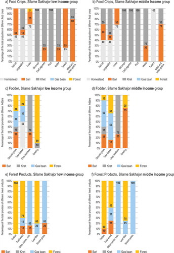
In the scoring exercise, the production of each crop harvested from the different patches was estimated. The relative contribution from the different patch types to the provision of food, fodder and forest products differs not only between the two study areas but also between social groups and patch locations within the landscape. and show the different uses and relative importance of specific landscape patches by two income groups in Rampur and Silame Sakhajor, respectively. They also show the multipurpose uses of different patches.
Figure 3. The estimated proportion of different food crops, feeds, fuel wood and timber harvested in different land use patches in Rampur. Other constr. mtrl. - Other construction material
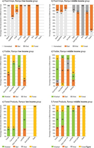
Figure 4. The estimated proportion of different food crops, feeds, fuel wood and timber harvested in different land use patches in Silame Sakhajor. Other constr. mtrl. - Other construction material
Rampur
Rampur village is located on the drier southestern side of Ramechhap. The households are a mix of the majority ethnic groups Tamang and Newar with a minority of families of Magar and Dalits ethnicity. The village is spread out between two mountain ridges and the various social groups have settled in different hamlets on the slopes. Most of the community forest is located below the village and stretches up to the village centre in two thin strips. Though the forest had recovered to a certain degree since the late 1980s there was a destructive forest fire in 2015. The use of community forest is regulated by the CFUG and there are specific rules and time periods allocated for the collection of fuel wood and fodder. Grazing is only allowed in small areas on a rotational basis during certain periods. Household livestock holdings are typically 1–2 buffalos, 1–2 cows and 3–10 goats and some farm also have hens and ducks.
The social and bio-physical patterning of the landscape means that the forest is not equally accessible to all community forest users. The low-income farmers who were part of the patch scoring exercise (-point 3) were all Tamang households living in a hamlet just next to the community forest area (). This allowed them to make frequent use of the forest. Some Tamang households prepare and sell airakh, a locally distilled spirit normally made from millet and need large amounts of firewood, which they collect from the community forests under certain regulations. The patch scoring middle income group were mostly Newars, an ethnic group known to be skilled commercial farmers. From their hamlet (-point 2), the forest is distant and downslope. A lack of time combined with the effort required to carry forest products upslope means that their forest use is limited.
In the household interviews, most of the poor respondents said that bari and kharbari now largely met their fodder and fuel wood needs which in the past they got from the community forests. There was a consistent account of declining use of community forests in the two other case villages in Ramecchap. Kharbari land was traditionally managed for producing khar or grass used as thatching material. The khar species were planted and maintained through weeding. Now there are few khar roofs and the kharbari areas have therefore become the land where people grow and collect grass and tree fodder for livestock.
The declining level of forest use reported in the interviews is however not fully reflected in (). The frequent collection of fodder and forest products from the forest described in c,e is accounted for mainly by the Tamang hamlet located next to the community forest. a,b shows how Tamang low-income farmers only have bari land for their food cropping. They manage their bari plots intensively for maize, millet, lentils etc. and the trees on these bari fields are important sources of animal feed (c, d) and fuel wood (e, f) in combination with the kharbari areas. Thus it is the locality in the landscape and proximity to forest rather than income level that determine different household’s levels of forest use.
While the airakh makers in the Tamang hamlet can use the community forest resources for income-generating activities, this has not been the case for other social groups which in the past have used forest resources. A Dalit blacksmith, for example, complained that the CFUG had prohibited him from taking out timber from the community forest for charcoal making. His clients, therefore, have to bring their own charcoal when they need his services. They collect this from their bari and kharbari fields and not from the community forest.
Most of the patch scoring middle-income Newar households have areas of khet land in the valley bottom in addition to their upland bari fields (). These khet fields are usually very small (e.g. 0.15 ha) but irrigation allows for double and even triple cropping. The Newars hardly use the community forest, and the kharbari land in combination with the bari fields cover the fodder and fuel needs of these households. However, independent of their use of the community forest, all members of the CFUG are required to patrol the forest area about once every 2 months.
For both income groups, a notable contribution to the household food economy comes from the homestead patch (). The food items produced in the homestead include food items such as sagh, other vegetables, fruits and spices, indicating the importance of the homestead to a households’ nutrition security.
The landscape use in Rampur is thus determined by socially based land ownership patterns with different capacities and abilities to access the forest. However, cutting across this differentiation is the lack of farm labour and increasing water scarcity which we return to later.
Silame Sakhajor
Silame Sakhajor village in Sindhuli provides a strong contrast to Rampur. Households migrated from mid-hills, including from Ramecchap about 3–4 decades ago and apart from a few Tamang are mainly Newar households. The mix of agricultural fields and forest vegetation has created a mosaic landscape. The Silame Sakhajor households are scattered along a water stream and the community forest surrounds the inhabited areas (). This spatial arrangement gives most households relatively easy access to forest areas. In contrast to the Rampur community forest where the CFUG management started with a degraded forest, the community forest handed over to the Silame Sakhajor village was a relatively large and healthy broadleaf forest dominated by valuable saal trees.
With a rich forest, the Silame Sakhajor CFUG has been able to manage the forest to meet members’ needs, as reflected in which shows the relative contribution of fodder and fuel wood coming from the forest in both income groups. Some families even use the community forest for generating extra income by selling firewood to hotels in the nearby town of Sindhulimadi. Collection of fuelwood for private sale in a community forest area is in principle not allowed, but is done with discretion by Tamang women who collect bundles of fuelwood at dawn and other villagers do not protest.
After much conflict on how the forest should be managed and used when the CFUG was created (1995), the CFUG committee decided to create a semi-individual forest patch called gas baan. This literally means fodder forest and lies on the outer border of the community forest in a sparsely treed 5–20 meter strip. This has been divided into parcels of about 0.5 hectare for forest user group members to manage individually. Most households therefore have a gas baan lot near their house and manage it for fodder, fuel wood and construction material (). Several households have a relatively large number of livestock (e.g. 2 oxen, 1–2 buffaloes 1–2 cows, 6–8 goats and some hens) and combine the fodder production from their gas baan with forest fodder. The low-income households with less farm land rely more on the use of forest for grazing than the better-off families (c-f).
As can be seen in ,b), both income groups have khet land. Owning of khet land in Silame Sakhajor is not an indicator of wealth status as it is in Rampur. Rather it is the size of the khet holding and investments made in the nearby town of Sindhulimadi that indicates a households’ wealth, a pattern that was also found in the two other Sindhuli case villages. The relatively large areas of irrigated khet (0.3–0.5 ha) fields combined with bari land provide the middle-income households in Silame Sakhajor with a substantial income. The poorer families with smaller khet plots (0.1–0.3 ha) rely on their irrigated land as well, but their bari land is also very limited. In general, the poorer families need to use resources from more patches in the landscape for both food, fodder, fuel wood than the middle-income farmers (c-f). The homestead patch is as with Rampur is important for planting vegetables, fruits, tubers and spices.
Labour as a limiting resource for farming
With the progressive shrinking of farm size across generations and with no room for expanding the cultivation boundary it became impossible by the 1980s for many households in mountain villages such as Rampur to survive. Many migrated southwards towards the lowland in search of land and founded new villages such as Silame Sakhajor.
Most of the Rampur smallholders only produce sufficient food for half of the year or less from their combination of fields/patches and need additional income which comes from remittances sent by family members or other non-farm sources, such as making bamboo products, iron work, construction work, small shop keeping, airakh making, or renting out a house in town. The young men in particular leave to find paid work elsewhere, usually abroad and the Rampur CFUG executive committee estimated that as many as 70% of the households have at least one family member working away. This has led to labour scarcity for agriculture.
There is also increasing competition for labour by the Silame Sakhajor households. But in contrast to Ramechhap where many youths are pushed to into a foreign labour market, there are more work opportunities to be found locally around the rapidly growing town of Sindhulimadi two kilometres away. According to its CFUG executive committee only 20% of the Silame Sakhajor households had a member working abroad. One young interviewee explained how he had worked abroad for about 2 years and had now returned to set up a local carpentry workshop. He estimated that the workshop income would be less than his work abroad, but he expected a reliable income from making furniture and he valued being able to live together with his family. The better-off households had made profitable property investments in Sindhulimadi (and in Kathmandu). However, the fertile landscape in combination with the closeness to an urban market made it feasible to live from what farm land produced in the village and the villagers sell agricultural surplus, processed produce (milk, airak) and ‘forest’ products (fuel wood). The labour shortage is somewhat mediated at peak labour demand (e.g. paddy transplanting) by traditional labour exchange arrangements which the households have maintained, drawing on their joint history as settlers and shared ethnic identity.
The decreasing availability of farm labour means that farming families in both locations carefully balance their labour resources between outside opportunities and their farm production, but the constraints and opportunities differ. Whereas Silame Sakhajor households seek to maximise harvest output on their khet fields and forest areas, Rampur minimise their labour input on their bari and kharbari land. Sugden et al. (Citation2018) found that many households cannot cover their costs of living by remittance alone and continue to depend on their agricultural production. households with the best migration outcomes were those with reliable subsistence production, allowing them to strategically invest the remittances rather than live of them. Households in Rampur survive primarily due to remittances and off farm income but have not prospered.
However, the major earthquake that hit Nepal in April 2015 had unexpected economic consequences. Few people were killed in the Ramecchap but the earthquake had three effects. First there was extensive damage of houses and buildings in both rural and urban areas imposing costs for rebuilding. But second the reconstruction aftermath created a ‘boom’ of local working opportunities and third a number of local water sources took new routes and/or dried out as a result of the earthquake. The need for temporary construction labour for the reconstruction created a notable rise in local wages. During the time of the field study the wages for a day’s labour were almost double those from before the earthquake, an income opportunity many of the Rampur households have tried to benefit from. This has had knock on effects in terms of labour availability and costs.
Changing land use–intensification through labour in Rampur and irrigation in Silame Sakhajor
There are consequences when a labor-intensive farming system loses labour and an increasingly drier environment reduces crop productivity. Land use practice in Rampur now speaks to a logic of managing constraints and risks rather than that of striving to maximise production and market engagement. Firstly, the localised land intensification management efforts are primary focused around subsistence production. All the farmers interviewed, as found earlier in Dolakha (Marquardt et al. Citation2016), reported that their yields had increased considerably during the last decades. They explained that they have about half the land that their parents used to have. However, the number of food secure months (which range from 5 to 12) in the year are the same or even higher in comparison to 20 years ago, indicating an intensification of the whole agricultural system combined with decreasing household sizes. The increased crop production is a result of the increased use of animal manure due to the shift to stallfeed livestock and chemical fertilizer. They are also using new varieties. But apart from some small pockets of cash cropping (e.g. cauliflower and cabbage), the major part of this crop produce is for the own household consumption. The imperative to meet subsistence needs by Rampur households speaks to the limits of remittance flows to secure household economies (Marquardt et al. Citation2016; Sugden et al. Citation2018).
Secondly, the logic of household practice is essentially that of a peasant household (van de Ploeg Citation2013) seeking to balance labour investment against consumption needs. Households concentrate their limited labour to the most fertile plots close to the homestead and the more distant lower productivity areas are gradually converted towards tree-based land uses such as kharbari land or private forest. An increasing wildlife population cause large harvest losses in certain areas and these have pushed land owners to convert their distant lands to more extensive tree production. In this transformative process, tree fodder production has moved from the community forest area into the private agricultural bari land (). However, in none of the Ramecchap study villages did the villagers talk about these as bajho jagga. Rather, they described a spatial management of resources where land use transitioned from bari into kharbari. When bari land is converted into kharbari it normally involves some kind of limited management input such as weeding and protection from grazing animals. But the crucial driver of the land-use shift is the reduced labour availability.
With increasing frequency of drought the importance of livestock appears to have increased. Several households reported that their main agricultural income was gradually shifting away from selling small quantities of their grain to selling a couple of goats. Their livestock herd has not necessarily increased in numbers although there has been a shift to keeping improved goat breeds. Although there is more fodder available in the landscape today (in the bari and kharbari patches) in comparison to when the community forest was established, the Rampur farmers however said it was risky to increase goat numbers due to the insecurity of water supply.
Thirdly, the bari land use in Rampur is increasingly diversified to produce a larger variety of products (). In many cases it provides almost all the resources households needed; a range of food and tree fodder, fuel wood, construction material and even charcoal that used to be seen as forest products.
Silame Sakhajor landscape is also the result of enormous labour investments. The Silame Sakhajor villagers’ first step for land use intensification was to use the local water resources to expand their khet fields. The farmers use fertilisers, chicken manure and improved seeds to increase their harvests. The khet production is focused on rice and vegetables to be sold in the adjacent town. Several middle-income households in Silame Sakhajor have specialised in intensive poultry raising and generating high-value manure.
The proximity to an urban market has stimulated intensification and semi-commercialisation of farming. However, as with Rampur the livestock component of the farming system is central. The size of livestock holdings of the Silame Sakhajor households reflects the almost free access to fodder. The gaas ban areas, as with the bari land and the kharbari areas in Rampur secure feed for animal production, but at a different scale and on common land. Both illustrate the importance of animal husbandry to the household and how trees remain at the heart of the farming system. But now tree fodder, which traditionally has been seen as a ‘forest product’ is mainly produced in patches outside the community forest. Yet neither gas baan, tree production on bari land nor kharbari fields are officially considered as land uses with a role in agricultural production. From a forestry perspective, at best they count as degraded forest land.
However food crops and fodder depend on reliable rainfall or irrigation. But with declining rainfall and increasing periods of drought in the hills agriculture is becoming more risky and less productive. Adaptive responses are site specific (Gentle and Maraseni Citation2012; Bhattarai et al. Citation2015) and the possibilities of coping with climate change depend on the availability of water sources. Thus water scarcity in Rampur and relative water abundance in Silame Sakhajor have encouraged two contrasting trajectories of land-use change.
Water – as a constraint and an opportunity
In the last 5–6 years Ramecchap has had crop failure and reduced rainfall. The case villages lie across a spectrum of water availability. In Rampur the reduced water availability is driving changes in production patterns but in Golmarja where water stress is acute, the forest has started to dry out. In Sindhuli water is abundant and the concern is more with torrential rains and floods sweeping away khet land on the banks of the river.
In Rampur the 2015 earthquake caused several water sources to dry out and many families experienced an acute shortage of drinking water and several have had to buy water. One family reported that each month they spent around 1000 rupees (9 USD) for water, paid for by their son in law’s work in construction. The poorest households who cannot afford such costs brought their water from a well 30–40 minutes’ walk downhill. Some households have started to collect rain water from house roofs for the animals and washing purposes, and in some cases also for small scale drip irrigation of vegetables. These water collecting practices function best with steel roofs rather than the traditional straw roofs, a common feature of poor families’ houses.
With the drought in Rampur the area of maize was reported to have declined. The driest areas of bari land has become unworkable and households are gradually converting them into kharbari. As much as 25% of the bari fields was reported to have been converted to kharbari. There is a gradual shift from food production towards goat fodder production on the lands, pushed by the drier climate. There is also a shift to goats from other livestock as they require less water.
In Silame Sakhajor, the land conversion process is working the other way around; by using local water resources bari land is levelled and converted into irrigated khet fields, leading to double or triple cropping. The livestock is easily watered in local streams.
However, even in Silame Sakhajor there is an emerging concern about future access to drinking water, as it comes from a distant source and the pumping arrangements do not always work. Some better-off households have dug their own wells. Several villagers have observed falling water tables and periods of insufficient water for their irrigation needs as a result of the increasing use of irrigation in the village
Discussion
Sugden et al. (Citation2018) did not find abandoned land in their three study sites in eastern Nepal and nor did we in our six sites. This does not in itself dismiss the possibility that in other locations land abandonment may happen and degradation occur. In response to the narrative of land abandonment (Ohja et al. Citation2017), we agree that bari land is being converted to uses other than crop production. But our evidence is clear that it is not un-managed but simply being used for different purposes, often to less intensive management.
The problem is that formal land use classifications do not help see what is actually going on in this agro-ecologically complex mountain environment. Presumptions about what is proper land use affect how changes are assessed and judged. The narrative of land abandonment as a proxy for land degradation is a narrow sectoral understanding of complex land-use changes. We are unconvinced that land which has not been ploughed for 2 years, which is how land abandonment is defined by Nepalese authorities, is necessarily abandoned (Jaquet et al. Citation2019, 1349). Moreover, conversions to other forms of land use such as grazing, grass or shrubs do not necessarily lead to environmental degradation. Goat keeping can as our evidence suggests be seen as a strategic adaptive response and it is doubtful that permanent vegetation on terraces would generate more erosion than annual crop production. Indeed from our observations, the retreat of the cultivation boundary and the concomitant regeneration of perennial vegetation has environmental benefits in this risk-prone environment. Whether or not land-use changes provoke environmental degradation is a site-specific question.
The wider land abandonment literature addresses both the degrading and regenerating outcomes of land abandonment. It tends to focus on the ecological and environmental effects of abandonment including heterogeneity in the landscape, species pools, biodiversity, climate and the biophysical conditions (e.g. Benayas et al. Citation2007; Sitzia et al. Citation2010; Quiroz et al. Citation2014). The importance of site specificity in terms of effects is usually highlighted. But as Quiroz et al. (Citation2014) note, different studies on impacts of land abandonment for similar land uses and geographical locations often reach conflicting conclusions in terms of the negative and positive effects of changes in agricultural landscapes. In short a much more nuanced story than the bajho jagga debate offers is needed to address the complexities of land-use change. For the fragile ecologies of the Nepalese mid-hills and the Chure range, policy needs to be more attentive to the multiple land uses and their production and recovering landscape outcomes. However the ecological aspects of land-use change are only a part of the land-use change story and as we show, the social dimensions of migration, labour, shifting production patterns and climate change responses are all central for understanding land-use dynamics. We suggest that a patch approach that takes account of niche and adaptation responses in a highly variable agro-ecological environment (Jodha Citation1992) and of its socially differentiated nature is analytically useful for understanding these land-use dynamics.
Our findings point strongly to the close integration between crop and tree land-use practices within the village landscape. This is central to the mid-hill agriculture but also underpins land use practices in more environmentally favourable areas. Neither the sectoral lenses of forest and agricultural authorities and institutions, nor the agricultural land use classification systems (Scott Citation1998) manage to see or appreciate the fine details of what farmers do and their rationale for doing so. Likewise, agroforestry, which has a wider notion of land-use systems (ICRAF Citation2014) does not incorporate the whole span of land use practices shown in this paper, or take account of how they are used in relation to each other. For example, many bari plots are complex agroforestry fields, while the irrigated khet fields, fertilised with manure, are intensively managed just for annual crops, and in the fodder areas there is no grain production. From the farmer household and the integrated landscape perspective, the livestock provides the link between different spaces in the terrain.
Observations on the micro-management of the hill landscape for subsistence purposes as evidenced in this paper have a long history (see Schroeder et al. Citation1985). But our evidence also raises new questions. Earlier observations spoke to conditions where the margins of cultivation were being pushed to the limits under acute population pressure (Blaikie et al. Citation1980). Now the pressure on land in the mid-hills has been reduced as a result of labour migration overseas and the growth of a remittance economy. Forests have recovered although the ecosystem flows between forests and agriculture have now largely been severed. But in agreement with van de Ploeg (Citation2014), despite the remittance income flow, the logic of production remains essentially a subsistence and peasant one, heavily dependent on farm labour. This in part is due to the limits and precariousness of the remittance flow itself which while relieving the household consumption demand is sufficiently unreliable for many to provide a means to accumulation and prosperity (Sugden et al. Citation2018). Outside the Mid-hills, as our findings from Sindhuli show, remittance flows are not the only source of non-farm income, and in a more productive environment, close to a growing urban economy, agriculture is more market oriented.
But there is no agrarian transition under way with a systematic move to market-oriented production or evidence of land accumulation. Farmers may leave the countryside but do not sell their land, and agricultural production is becoming concentrated to the most fertile areas but mainly for subsistence purposes with trees and forest-supporting land-use intensification. Where surpluses can be generated, as in Silame Sakhajor, it will be sold. The two cases show how different forms of transition and intensification are happening at the same time but in different patches and how extensive land uses are part of other intensification strategies. It speaks to a rationale of intensification of labour rather than land use. The patches concept can help us understand different agrarian trajectories and the ways that land use intensification can contribute to household survival (van de Ploeg Citation2013).
Concluding remarks
The long-term decline in farm size is inexorable and the ability of hill farming systems to support even a subsistence economy has its limits. We are not seeing here a rapid process of commercialisation and land accumulation leading to dispossession and landlessness as Li (Citation2014) has reported from Indonesia. There are already high levels of landlessness (Alden Wiley et al. Citation2009) in Nepal but a similar process of reaching land’s end where many of Nepal’s Mid-hill rural population can neither find sufficient work in the agrarian or urban economy may be approaching. Moreover, it seems that, apart from reaching or not a point of land’s end (Li Citation2014), villages such as Rampur (and to a degree also Silame Sakhajor) have reached the limits of labour and water resources. The consequence is both intensification and extensification happening in parallel but in different parts of the landscape.
While we cannot foresee the future any more than poor rural households in Nepal’s Mid-hills can, this analysis of actual land use points to the ways in which such households are adapting to the constraints that they face now of labour availability, climate risk and drought. The adaptive responses are generally not seeking to generate greater income from agriculture as promoted by many development interventions as suitable climate adaptation responses (Khatri Citation2018). Rather the adaptations farmer make are more to secure the subsistence component of living within the labour resources available. The apparent direction that these are taking – towards a more tree and livestock-based farming system in the hills – brings a new twist to processes of continuity and change in the Himalayas.
Acknowledgements
We would like to give special thanks to all the village and state agency informants who generously provided their time and knowledge for this research.
Disclosure statement
The authors declare that they have no conflict of interest.
Additional information
Funding
Notes
1. The Chure is a low mountain range in the foothills of Himalaya consisting of mountain and flat terrain in valleys.
2. We used the Nepalese word jaggako tukra for the term ‘patches’ in the conversations in the study villages.
References
- Alden-Wily L, Chapagain D, Sharma S 2009. Land Reform in Nepal: Where is it Coming from and Where is it Going? The Findings of a Scoping Study on Land reform in Nepal for DIFID. Published by the authors.
- Benayas JR, Martins A, Nicolau J, Schulz JJ. 2007. Abandonment of agricultural land: an overview of drivers and consequences. CAB Rev Perspect Agri Veterinary Sci Nutrition Nat Res. 2(57):1–14.
- Bhattarai B, Beilin R, Ford R. 2015. Gender, agrobiodiversity, and climate change: a study of adaptation practices in the Nepal Himalayas. World Dev. 70:122–132. doi:10.1016/j.worlddev.2015.01.003.
- Blaikie P, Brookfield H. 1987. Land degradation and society. London, UK: Methuen.
- Blaikie P, Cameron J, Seddon JD. 1980. Nepal in crisis: growth and stagnation at the periphery. Delhi, India: Adroit Publishers.
- Blaikie P, Coppard D. 1998. Environmental change and livelihood diversification in Nepal: where is the problem? Himalayan Res Bull. 18(2):28–39.
- Gautam AP, Webb EL, Shivakoti GP, Zoebisch MA. 2003. Land use dynamics and landscape change pattern in a mountain watershed in Nepal. Agric Ecosyst Environ. 99(1–3):83–96. doi:10.1016/S0167-8809(03)00148-8.
- Gentle P, Maraseni TN. 2012. Climate change, poverty and livelihoods: adaptation practices by rural mountain communities in Nepal. Environ Sci Policy. 21:24–34. doi:10.1016/j.envsci.2012.03.007.
- Hobley M, Jha C. 2012. Persistence and change: review of 30 years of community forestry in Nepal. Kathmandu, Nepal: HURDEC Nepal.
- ICRAF. 2014. Agroforestry, a landscape approach: from promoting specific agroforestry technologies to advocating a portfolio of tree options within the landscape. World Agroforestry Centre. [accessed 2020 Jun 9]. http://apps.worldagroforestry.org/downloads/Publications/PDFS/BR14079.pdf
- Ives JD, Messerli B. 1989. The Himalayan dilemma: reconciling development and conservation. London, UK: Routledge.
- Jaquet S, Kohler T, Schwilch G. 2019. Labour migration in the Middle Hills of Nepal: consequences on land management strategies. Sustainability. 11(5):1349. doi:10.3390/su11051349.
- Jodha NS. 1992. Mountain perspectives and sustainability: a framework for development strategies. In: Jodha NS, Baukshota M, Partap T, editors. Sustainable mountain management. Volume 1, perspectives and issues. New Delhi, India: Oxford & IBH Publishing Co. Pvt. Ltd; p. 41–82.
- Khatri D 2018. Climate and development at the third pole: dynamics of power and knowledge reshaping community forest governance in Nepal (dissertation 2018:41). Uppsala: Department of Urban and Rural Development, Swedish University of Agricultural Sciences, Uppsala.
- Khatri D, Shrestha K, Ojha H, Paudel G, Paudel N, Pain A. 2017. Reframing community forest governance for food security in Nepal. Environ Conserv. 44(2):174–182. doi:10.1017/S0376892916000369.
- Li TM. 2014. Land’s end. Capitalist relations on an indigenous frontier. London, UK: Duke University Press.
- Marquardt K, Khatri D, Pain A. 2016. REDD+, forest transition, agrarian change and ecosystem services in the hills of Nepal. Hum Ecol. 44(2):229–244. doi:10.1007/s10745-016-9817-x.
- Niraula RR, Gilani H, Pokharel BK, Qamer FM. 2013. Measuring impacts of community forestry program through repeat photography and satellite remote sensing in the Dolakha district of Nepal. J Environ Manage. 126:20–29. doi:10.1016/j.jenvman.2013.04.006.
- Ojha HR, Shrestha KK, Subedi YR, Shah R, Nuberg I, Heyojoo B, Cedamon E, Rigg J, Tamang S, Paudel KP, et al. 2017. Agricultural land underutilisation in the hills of Nepal: investigating socio-environmental pathways of change. J Rural Stud. 53:156–172. doi:10.1016/j.jrurstud.2017.05.012.
- Paudel D. 2016. Re-inventing the commons: community forestry as accumulation without dispossession in Nepal. J Peasant Stud. 43(5):989–1009. doi:10.1080/03066150.2015.1130700.
- Quiroz C, Beilin R, Folke C, Lindborg R. 2014. Farmland abandonment: threat or opportunity for biodiversity conservation? A global review. Front Ecol Environ. 12(5):288–296. doi:10.1890/120348.
- R K S, McCarthy JF. 2016. Reconsidering the links between poverty, international labour migration, and agrarian change: critical insights from Nepal. J Peasant Stud. 43(1):39–63. doi:10.1080/03066150.2015.1041520.
- Regmi MC. 1977. Landownership in Nepal. Delhi, India: Adroit Publishers.
- Schroeder R. 1985. Himalayan subsistence systems: indigenous agriculture in rural Nepal. Mt Res Dev. 5(1):31–44. doi:10.2307/3673221.
- Scoones I, Dzingirai V, Anderson N, Macleod E, Mangwanya L, Matawa F, Murwira A, Nyakupinda L, Shereni W, Welburn SC. 2017. People, patches, and parasites: the case of Trypanosomiasis in Zimbabwe. Hum Ecol. 45(5):643–654. doi:10.1007/s10745-017-9929-y.
- Scott JC. 1998. Seeing like a state: how certain schemes to improve the human condition have failed. London: Yale University Press.
- Sinare H, Gordon LJ, Enfors Kautsky E. 2016. Assessment of ecosystem services and benefits in village landscapes – A case study from Burkina Faso. Ecosystem Service. 21:141–152. doi:10.1016/j.ecoser.2016.08.004.
- Sitzia T, Semenzato P, Trentanovi G. 2010. Natural reforestation is changing spatial patterns of rural mountain and hill landscapes: a global overview. For Ecol Manage. 259(8):1354–1362. doi:10.1016/j.foreco.2010.01.048.
- Sugden F, Seddon D, Raut M. 2018. Mapping historical and contemporary agrarian transformations and capitalist infiltration in a complex upland environment: A case from eastern Nepal. J Agrarian Change. 18(2):444–472. doi:10.1111/joac.12223.
- Tiffen M, Mortimore M, Gichuki F. 1994. More people, less erosion: environmental recovery in Kenya. Chichester, UK: Wiley.
- van de Ploeg JD. 2013. Peasants and the art of farming: a Chayanovian manifesto. UK: Practical Action Publishing.